Showing 2349 items matching " mountains"
-
 Bendigo Historical Society Inc.
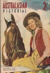
Magazine - AILEEN AND JOHN ELLISON COLLECTION: THE AUSTRALASIAN PICTORIAL
The Australasian pictorial Magazine issued October 1, 1947. Price 2 shillings. The magazine has 67 pages. On the cover a outback girl in yellow pants, white and red shirt, a red vest and an akubra hat, she is holding a thoroughbred horse. The book is full of photos of Australian people, cities, industries, fields, beaches outback, mountains, indigenous people.book, magazine, the australasian pictorial -
 Whitehorse Historical Society Inc.
Document, Zander Avenue, 7/01/1986
Memories by Merle Duncan recorded 7/1/1986. Zander Avenue named after the Zanders who had an apple orchard there. Wright Family owned a milk bar in Springfield Road and they built Mountain view shops in Springfield Road. The old manse, now the Nunawading North Community House was their home. Nicoll Reserve was a pear orchard owned by the Aytons.roads and streets, zander avenue, nunawading, nunawading, duncan, merle, wright family, mountain view shops, springfield road, nunawading, nicoll reserve, ayton family, zander family -
 Mont De Lancey
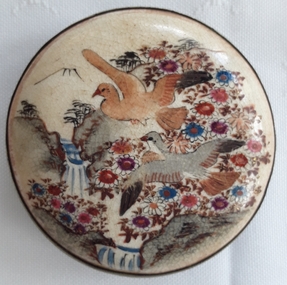
Accessory - Belt Buckle
Worn on a ladies belt for decoration. It could be Japanese as there are similar pieces on the internet.An antique round hand painted Japanese style ladies ceramic belt buckle with two birds, rock cliffs, flowers, two waterfalls and a mountain which could represent Mt Fuji in the background. It is mounted on a brass surround and the back has a hook for clasping to the other end of the belt and a thin metal bar. There is a small X signature stamped under the hook.A small X stamped on the back.belt buckles, belt accessories, gibson collection -
University of Melbourne, Burnley Campus Archives
Album - Colour 35mm slides, Kodachrome, Excursion to Canberra, 1990
(1) 48 colour slides of views of Canberra including the National Botanic Gardens, Mt Ainslie, Black Mountain and Mt Kosciusko. Most labelled. (2) The Australian Garden Journal Vol 9 No 4 August/September 1990. Contains several articles on Canberra. Probably from a student excursion to Canberra as they were found in the former Staff Room. Not scanned.canberra, national botanic gardens, mt ainslie, black mountain, mt kosciusko, the australian garden journal, excursion -
Lara RSL Sub Branch
Book, Jungle Warfare - With the Australian Army in the South West Pacific, 1944
This is the fourth book in this series to the people at home during WWII. Stories of military operations in the jungle and Kenai, mountains and swamps of New Guinea. There the terrain and climate gave to the fighting a character of its own, unlike anything experienced by Australians previously and never to be forgotten by those who took part in it.Jungle Warfare - With the Australian Army in the South West Pacific. Brown front and back cover with Ore text and picture of soldier carrying his webbing. Same text on the spine. The inside front and back cover has text ore coloured text on a brown background. Photographs, illustrations, poems, stories, paintings jungle warfare, new guinea, australian army, royal australian navy, united nations, amphibious operation, hidden battlefields, shaggy ridge, operational drop, life-saving moresby style, stretcher bearing -
Lara RSL Sub Branch
Book, Jungle Warfare - With the Australian Army in the South West Pacific, 1944
This is the fourth book in this series to the people at home during WWII. Stories of military operations in the jungle and Kenai, mountains and swamps of New Guinea. There the terrain and climate gave to the fighting a character of its own, unlike anything experienced by Australians previously and never to be forgotten by those who took part in it.Jungle Warfare - With the Australian Army in the South West Pacific. Brown front and back cover with Ore text and picture of soldier carrying his webbing. Same text on the spine. The inside front and back cover has text ore coloured text on a brown background. Photographs, illustrations, poems, stories, paintings. This book has a paper jacket cover - slightly torn. jungle warfare, new guinea, australian army, royal australian navy, united nations, amphibious operation, hidden battlefields, shaggy ridge, operational drop, life-saving moresby style, stretcher bearing -
Lara RSL Sub Branch
Book, Jungle Warfare - With the Australian Army in the South West Pacific, 1944
This is the fourth book in this series to the people at home during WWII. Stories of military operations in the jungle and Kenai, mountains and swamps of New Guinea. There the terrain and climate gave to the fighting a character of its own, unlike anything experienced by Australians previously and never to be forgotten by those who took part in it.Jungle Warfare - With the Australian Army in the South West Pacific. Brown front and back cover with Ore text and picture of soldier carrying his webbing. Same text on the spine. The inside front and back cover has text ore coloured text on a brown background. Photographs, illustrations, poems, stories, paintings jungle warfare, new guinea, australian army, royal australian navy, united nations, amphibious operation, hidden battlefields, shaggy ridge, operational drop, life-saving moresby style, stretcher bearing -
 Orbost & District Historical Society
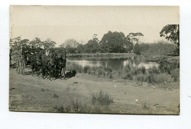
black and white photograph, late 19th - early 20th century
This photograph was taken at the junction of the Snowy and Brodribb Rivers. The Snowy River starts in New South Wales on the slopes of Mt Kosciuszko, Australia’s highest mountain, in New South Wales. It flows into Bass Strait at Marlo in Victoria. The Brodribb River is a tributary of the Snowy which enters the estuary at Marlo. This is a pictorial record of a road in Marlo near Orbost in the late 19th-early 20th centuries. It also depicts the transport used at that time.A black / white photograph of four men in suits seated in a horse - drawn buggy on a dirt road alongside a creek or river. There appears to be another horse - drawn vehicle behind them.on back - "at the Brodribb - Snowy junction. this road was corduroy (packed logs of tea trees?)brodribb-river snowy-river marlo transport-horse-drawn -
 Mt Dandenong & District Historical Society Inc.
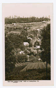
Photograph, View at Sassafras, Vic, c1930
View down the Main Street of Sassafras looking south with the Mechanics Institute in the centre of the picture. The raspberry patch in the foreground belonged to Woniger Hansen who built Mountain Rest (Rostrevor). The land was subdivided after his death in 1923. The raspberry patch is in the area of the current Mason Grove.Black and white Rose Series postcard P. 4765 looking south down the Main Street of Sassafras with buildings either side and berry patches in the foreground.On reverse POST CARD. THE "ROSE' SERIES DELUXE. A REAL PHOTOGRAPH PRODUCED IN AUSTRALIA. PUBLISHED BY 'THE ROSE STENOGRAPHS" Armadale. Victoria sassafras, rose series, rostrevor, woniger hansen, hansen, mechanics' institute, raspberry, raspberry crop, mountain rest, mason grove -
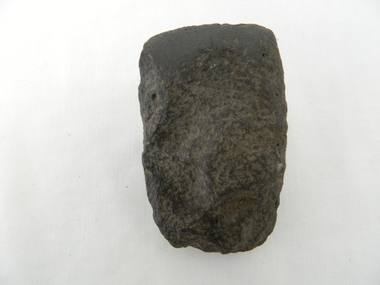 Kiewa Valley Historical Society
Axe Head, Before European settlement
This item was used well before European settlement and clearly demonstrates the development of the local Aboriginal tribes, Dhudhuroa and Yaitmathang in the use of a cutting /chopping implement, made from Mount William sourced material i.e. greenstone. This item was probably traded at the Bogong Mountain tribal yearly summer ceremoniesThe significance of this item places it at the fore front of human development in this region. The period when this tool was manufactured represents the time when the natural landscape had not been altered and the natural vegetation, fauna and flora, had not been subjected to imported species.This also proves that local tribes did live in this area and or the Bogong High Plains.Small ground edge stone axe head. Leading cutting edge very smooth and chiseled to a fine edge. Weight is, for its size fairly heavy. It is made from Greenstoneaboriginal tool stone ground-edge axe indigenous tool -
 Bendigo Historical Society Inc.
Book - Geographical dictionary
The Gazetteer presents an extensive a to z list of Victorian towns and villages, lakes, rivers and creeks, islands, bays, hills and mountains, runs and other localities and features. Entries include latitude and longitude, populations, proximity to other towns, local industries, coach and mail runs, hotels, churches and schools.Bailliere's Victorian Gazetteer and road guide containing the most recent and accurate information as to every place in the colony. Brown hardcover book, on the spine: Victorian Gazetteer with map 1865. The first and last pages are advertisements. The book has 442 pages listing every place in the colony. The map is not included. Compiled by Robert P. Whitworth. Published by Bailliere, Regent Street Unreadable name on first page and the name of F. Houston in blue pen on first page geographic dictionary, colony of victoria -
 Kiewa Valley Historical Society
Photograph - Mt Bogong - Tawonga, 06/05/1937
Mount Bogong located in the Alpine National Park and part of the Victorian Alps of the Great Dividing Range, is the highest mountain in Victoria, Australia, at 1,986 metres (6,516 ft) above sea level. The Big River separates the massif of the mountain from the Bogong High Plains to the south. From the nearby town of Mount Beauty to its summit, Mount Bogong rises more than 1,600 metres (5,200 ft), thus making it one of the highest peaks in Australia not only in terms of its elevation above sea level, but also in terms of actual base-to-summit prominence. Mount Bogong is a popular backcountry skiing mountain through winter but only has snow for the mid winter-spring months. It is around 30 kilometres (19 mi) by road and walking track or 12 kilometres (7.5 mi) direct to Mount Beauty. Falls Creek and Mount Hotham ski resorts are also nearby. Camping is relatively safe below the tree line but the summit ridgeline is very exposed. Emergency shelter is also available at Bivouac Hut on the Staircase Spur, and at Cleve Cole, above Camp Creek on the broad ridge to the south of the summit, and Michells Hut on the Eskdale Spur. Mt Bogong is a popular recreational venue in the Kiewa Valley for back country skiing and bush walking and is a favourite with sightseers and popular subject for photographersBlack and white photograph of Mt bogong taken from Tawonga - Thursday May 6th, 1937Handwritten on back of photograph. Thursday May 6th, 1937. Mt Bogong Tawongamt bogong, tawonga, kiewa valley -
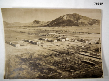 Bendigo Military Museum
Photograph - RAAF BARRACKS BOFU JAPAN, RAAF, 1946
Item is part of the BCOF Association Collection, refer Cat No 7625This is a large black and white photo. In the background are mountains. On right side of the photo, are some factories with tall chimneys. The middle ground is flat. It shows housing alongside roads. The foreground shows 10 major double storey buildings and three rows of single storey buildings The foreground, left bottom of the picture shows darkened devastated area. A solo tall chimney is on the right side.On rear - “81 fighter..... Occupation Forces. RAAF Camp (Barracks) Bofu, Japan 1946. This was previously a camp for Kamakazi pilots”ww2, bcof, japan -
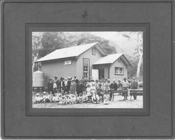 Halls Gap & Grampians Historical Society
Photograph - B/W, C 1927
This is a photo of the opening of the new Halls Gap School in 1927. The man on the chair with a walking stick is Dr. Fox.The photo shows a group of ten men, fifteen women, twenty two children (including one toddler) and one toddler in arms, posing outside a wooden building with a water tank on the left side. The four adults on the right are sitting/leaning on two benches. A sign on the side of the building reads "Halls Gap School 3058". There are large trees and a mountain range in the background.education, halls gap -
Bendigo Historical Society Inc.
Book - DAI GUM SAN - BENDIGO'S BIG GOLD MOUNTAIN
32 page soft cover booklet 'Dai Gum San - Bendigo's Big Gold Mountain' A Chinese Village Tourist Project for the City of Greater Bendigo. Describes the proposed development of what became the Golden Dragon Museum. Published by ther Bendigo Trust. 1974 Includes 16 colour photos of some typical Chinese architecture and scenes. Donated by Bob AulsbrookBendigo Trust -
 Nillumbik Shire Council
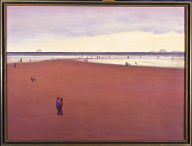
Painting: David ARMFIELD (b.1923 Melb AUS - d. 2010 Melb AUS), David Armfield, Untitled (Beach), c. 1975
David Armfield studied at the National Gallery School in the 1940s and turned to full time painting in 1965. RMIT printamking. He has won several art awards, including the Ramsay Prize - NGV School, the Redcliffe and in 1980 the Eltham Prize. Armfield is represented in the National Gallery collection, Art Gallery of NSW, Tasmanian Art Gallery, several regional art galleries across Australia as well as private collections. David Armfield first came to Eltham in the late 1903s on painting trips and used to camp on the banks of the Diamond Creed. He returned to Eltham in 1957 with his wife Joan who has subsequently become one of the district's potters, and built a mud brick house and studio in John Street on land adjoining Peter Glass. He has painted many landscapes in the district including intimate studies of the bush floor and the aftermath of bush fires.'Untitled' by David Armfield an oil on canvas painting depicts sand, sea, distant mountains and various figures scattered about in a typical Armfield landscape. The figures tend to be annonymous, sometimes included more to establish the scale than for a narrative purpose. The figures are well clothed and it could be assumed that it is not a hot summer's day. Depth is established by changing of colours and diminishing the size of the figures.david armfield, beach, eltham, nillumbik shire council -
 Lakes Entrance Historical Society
Photograph - Bridges, 1990
Also another photo taken laterColour photograph showing McKillops Bridge across the Snowy River in the High Country near Deddick, East Gippsland near the Victorian / NSW border, south side of bridge, road to Deddick just visible opposite end, taken from west end of bridge. River flowing to right, bridge of timber, steel and concrete, mountains around. East Gippsland Victoriabridges, waterways, topography -
 Benalla Art Gallery
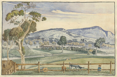
Watercolour, Elizabeth PARSONS, Cameron's Station, Pyrenees, c. 1890
... Mountains ...Born: Isleworth, Middlesex, England 1831; Arrived: Melbourne, Victoria, Australia 1870; Died: Melbourne, Victoria, Australia 1897VictorianGift of Mrs E.E. Ledger, 1982Rural landscape with house, fences, trees hills, a creek and a small figure carrying a fishing line. Thin, dark blue grey brushed timber frame.Recto: Signed "PARSONS" in black watercolour in l.l.c of composition; Not dated; Not titledwatercolour, landscape, tree, mountains, animals, cows, figures, fence, creek, colonial, buildings -
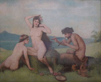 Benalla Art Gallery
Painting, Julian ASHTON, Bacchantes, 1892
... Mountains ...Born: Addlestone, Surrey, England 1851; Arrived: Melbourne, Victoria, Australia 1878; Died: Bondi, New South Wales, Australia 1942NeoclassicismGift of Mr Philip Bacon, 2002Two naked women listening to a Faun play twin pipes.painting, figures, faun, allegorical, flute, tambourine, flowers, nude, mountains, sky, mythical -
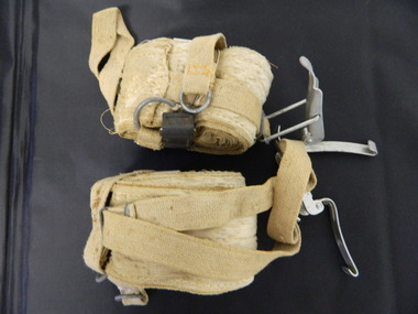 Kiewa Valley Historical Society
Ski Skins - Pair
Ski skins and webbing were introduced into the Victorian Alps by European skiers. Enthusiasts travelled to enjoy the snow and to explore the Victorian Alps including the Bogong High Plains. This equipment enabled them to travel over snow without slipping when going up hills. They took the skins off when they wanted to slide down hills. In later years waxes were used for cross country skiing and then 'fish tail' markings on the back of skis to enable skiers to travel distances up and down mountains. Later developments also included motor transport (replacing horses to get to the snow line) and roads to take skiers to the ski fields and mechanised tows to take skiers up mountains so they could ski down (downhill skiing).Skiers visited the Bogong High Plains especially during the years of the State Electricity Commission of Victoria's construction of the Kiewa Hydro Electric Scheme from the 1930's onwards. Tourists to the area increased during this time and influenced the development of Falls Creek.Long cream strips with soft short 'fur' on one side and a type of strong hessian on the back with the length of the middle and sides stitched. At one end an adjustable strap is attached to a steel, hinged clasp and at the other end is a loop that fits over the ski. A quarter of the way from each end is a steel attachment for fastening over the ski - the 'toe' end with a rubber embossed flap and the other with a short and long strap each with a steel ring at the end.On the rubber attachment: 'vinersa/pat uno'ski skins; bogong high plains; falls creek -
 Eltham District Historical Society Inc
Negative - Photograph, Timber Tramway at Wright's Falls, Kinglake District, c.1920
Man and woman stand beside timber tramway track at Wright's falls Kinglake. The tramway was constructed alongside the road to support the large traffic in firewood between the mountains to Whittlesea. The Wright family owned the land on which the Falls were situated and were sold for a penny an acre according to a Wright family story. This photo forms part of a collection of photographs gathered by the Shire of Eltham for their centenary project book,"Pioneers and Painters: 100 years of the Shire of Eltham" by Alan Marshall (1971). The collection of over 500 images is held in partnership between Eltham District Historical Society and Yarra Plenty Regional Library (Eltham Library) and is now formally known as 'The Shire of Eltham Pioneers Photograph Collection.' It is significant in being the first community sourced collection representing the places and people of the Shire's first one hundred years.Digital image 4 x 5 inch B&W Negshire of eltham pioneers photograph collection, kinglake, timber tramway, wrights falls -
 Kiewa Valley Historical Society
Photo - Bogong Village Township, October 8, 1946
In 1940 Field Headquarters for the Kiewa Scheme were established at Bogong with office, workshop facilities and accommodation for workmen, staff and some families constructed. (There had been a 'tent camp' on this site in 1939 but was destroyed by bushfires) Construction of accommodation continued until 1947. A total of 40 houses plus a hostel for single staff, post office, police station, medical centre and primary school all with water and sewerage and electricity supply. The staff hostel was known as Kiewa House and is now occupied by the Education Department. Lake Guy was named after Mr. L.T. Guy who was the Resident Engineer in charge of construction work and associated activities on the Kiewa area. He held this position from 1939 to November 1946 when he was transferred to Head Office. The Bogong Township was developed firstly as an accommodation centre (base camp) for construction workers employed under the Kiewa Hydroelectric Scheme. Due to the influx of European workers into the Township the beautification of the immediate surrounds (gardens etc.) had a distinct European flavour. This environment has been very beneficial for tourism in later years. At the completion of the scheme, in the 1960's, the village was opened to public/tourism use. Strict environmental control has not allowed for any extensive redevelopment in tourist accommodation and basically restricted it to the accommodation initially built for the construction workers. Activities such a bike riding, snow skiing, restricted horse riding and bush walking on the Alpine plains and mountains are now a viable part of the Kiewa Valley Tourist Industry. The lake is one of the many water storage reservoirs used to supply the power stations their main power to run the huge turbines generating the final product, electricityBlack and white photograph of Bogong Village which appeared in the Herald Sun newspaper on October 8, 1946. Page 13Handwritten on the back - Town of Bogong on a rugged mountain slope above Lake Guy. State Electricity Committee workers on the Kiewa Hydro Electric scheme live here in all electric homes. Stamped on the back - Copyright Not for reproduction Herald Sun Feature Service Melbourne Australiabogong village; lake guy; kiewa hydro electric scheme -
![Mount St. George, Addis Bay / [by] Nicholas Caire, circa 1876](/media/collectors/550653872162f11fb04854aa/items/57833f9fd0cdd1176c6828f5/item-media/57833ffdd0cdd1176c685980/item-fit-380x285.jpg) Kew Historical Society Inc
Kew Historical Society IncPhotograph, Anglo-Australasian Photographic Company, Mount St. George, Addis Bay, c. 1876
Nicholas Caire was born on Guernsey in the Channel Islands in 1837. He arrived in Adelaide with his parents in about 1860. In 1867, following photographic journeys in Gippsland, he opened a studio in Adelaide. From 1870 to 1876 he lived and worked in Talbot in Central Victoria. In 1876 he purchased T. F. Chuck's studios in the Royal Arcade Melbourne. In 1885, following the introduction of dry plate photography, he began a series of landscape series, which were commercially successful. As a photographer, he travelled extensively through Victoria, photographing places few of his contemporaries had previously seen. He died in 1918. Reference: Jack Cato, 'Caire, Nicholas John (1837–1918)', Australian Dictionary of Biography.An original, rare photograph from the series 'Views of Victoria: General Series' by the photographer, Nicholas Caire (1837-1918). The 60 photographs that comprise the series were issued c. 1876 and reinforced a neo-Romantic view of the Australian landscape to which a growing nationalist movement would respond. Nicholas Caire was active as a photographer in Australia from 1858 until his death in 1918. His vision of the Australian bush and pioneer life had a counterpart in the works of Henry Lawson and other nationalist poets, authors and painters.‘Mount St. George, Addis Bay’ : Views of Victoria (General Series) No.56 : Albumen silver photograph | Photo on card with Title and Description on reverse | Mounted 24 x 30 cm; Photo 12 x 17 cm.On Reverse: ‘Addis Bay is situated to the north-east of Appollo Bay, and very near Cape Patten. This mountain is 6,000 feet high, and commands one of the finest views on the Cape Otway Ranges. The ascent is a somewhat difficult one, but visitors to this locality not unfrequently make this a favourite outing.’nicholas caire (1837-1918), landscape photography -
 Robin Boyd Foundation
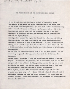
Document - Script, Robin Boyd, The Flying Dogtor and The Snowy Mountain's Secret. Adventure No. 6, The Lake Monsters, Episodes 44-52, 1963
This transcript outlines the storyline of the final adventure (no. 6) of The Flying Dogtor (The Lake Monster) in 4 chapters, episodes 44-52. The Dogtor is called to the Snowy Mountains Scheme to solve the mystery of a sea-serpent in Lake Eucumbene. After investigations around and under the water, he solves the mystery and is finally awarded suitably in Canberra.The Flying Dogtor" series was broadcast on Australian Television Network (later becoming the Seven Network) between February and April 1964 (see item D254 for schedule).Typewritten, quarto, carbon copy, 14 pagesOn top left 'Robin Boyd script for Flying Dogtor 14 pages' in Penleigh Boyd's handwriting.the flying dogtor, snowy mountains, robin boyd, crawford productions, manuscript -
 Falls Creek Historical Society
Print - The Australian Ski Yearbook 1937 advertisement image in frame
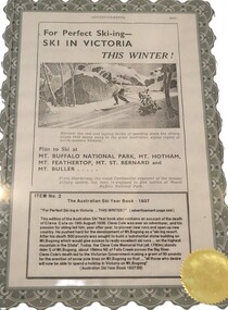
These items are from the private collection of George Shirling of Red Onion, Falls Creek. This advertisement was featured in The Australian Ski Yearbook 1937. George Shirling arrived in Falls Creek in 1962. He engaged Phil Nowell to build the original Koki Alpine Lodge which opened in 1965 with 14 beds. George operated the lodge with Michael “Baldy” Blackwell as manager. He also graduated in sport psychology in 1981 and was invited to become team psychologist for the Australian Winter Olympic team which went to Albertville, France, in 1992. He later owned the Red Onion Chalet. George credited the success of Koki to “Baldy” Blackwell. “Baldy” and Phil Nowell started the Trackers Mountain Lodge in partnership during the 1980s. In 1971 George sold Koki Lodge to Sigi Doerr. In 2024 the renamed Koki Alpine resort remains a highly popular destination in Falls Creek. George Shirling passed away on 27th February 2023. He had remained actively involved in Falls Creek and was generous with his time and knowledge, always an amazing supporter of The Falls Creek Museum and Falls Creek Village.This item is significant because it contained promotional material for Australian Ski Resorts and also honoured Cleve Cole.A black and white advertisement for Skiing in Victoria. It is accompanied by a detailed sign which explains key items in the publication. This edition of the Australian Ski Year book also contains an account of the death of Cleve Cole on 19th August 1936. Cleve Cole was ever an adventurer, and his passion for skiing led him, year after year, to pioneer new runs and open up new country. He pushed hard for the development of Mt. Bogong as a "skiing resort". After his death £500 was sought to build a "substantial stone building on Mt. Bogong which would give access to really excellent ski runs on the highest mountain in the State". Today, the Cleve Cole Memorial Hut (altitude 1,760m) stands 4kms south of Mt. Bogong, about 15kms NE of Falls Creek across the Big River. Cleve Cole's death led to the Victorian Government making a grant of £50 for the erection of snow pole lines on Mt. Bogong so that "all those who desire will now be able to spend a holiday in Victoria on Mt. Bogong" (Australian Ski Year Book 1937, page 55)ITEM No. 2 The Australian Ski Year Book 1937 "For Perfect Skiing in Victoria... THIS WINTER!" (advertisement page xxxi) george shirling, falls creek, the australian ski yearbook 1937, cleve cole hut -
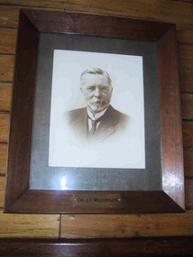 Parks Victoria - Mount Buffalo Chalet
Photograph, " DR J.F.WILKINSON"
'There are also a number of framed portraits, including those of...Dr. John Wilkinson, a doctor who started a practise in Bright in the late 1880's and helped develop the tourist potential of the Mount Buffalo Plateau. " (Pg 84, Historica, 2011) Dr John .F. Wilkinson was a significant figure in the pioneering of tourism at Mt Buffalo. A Doctor and resident of Bright, he and W.A. Staker were the founder members of the Bright Alpine Club formed in 1887 to promote the natural attractions of the Buffalo plateau. " They form the Alpine Club and charge a membership fee for guiding people up the mountain (led by official guides Bill Weston and Edward Carlisle). this is matched by a grant from the local shire council.... They advertise in the Argus and promote the Australian Alps, Bright district as "The Switzerland of Victoria'. Mt Buffalo, with the railways nearby, is the most accessible snowfield and becomes 'the cradle of skiing in Victoria'." (Pg 179 Historica . 2011) The initial funds raised by the Alpine club funded the Staker's walking track, the first easily accessible route up the mountain. . They engaged the services of early Victorian photographer Nicholas Caire, whose scenic photographs helped to promote the beauty of the mountain. The efforts of these gentlemen culminated in securing 2.800 acres for the one of the first National Parks in Victoria, 1898. Listed in Draft Inventory of significant Items. Framed sepia photograph. Grey mount in wooden frame. Portrait of Dr.J.F Wilkinson. Brass name plaque at base of frame. Hand finished / highlighted in places." DR J.F.WILKINSON" -
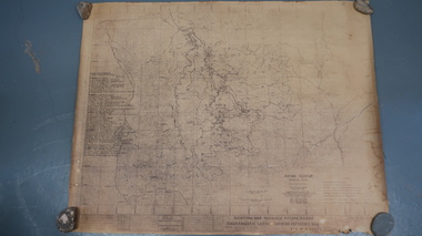 Kiewa Valley Historical Society
Map - Kiewa Scheme General Plan
Existing and possible future roads are numbered and named 1 - 45. The plan is based on an aerial photos taken March 1945. It includes revisions up to 1951. Signed by H.H.C. Williams, construction engineer. Mountains, rivers, roads and SECV places are named, also SECV infrastructure and construction eg. workers camps, Power stations.Significant for the information re the Kiewa Hydro Electric Scheme's development.Yellowed paper with brown print. Kiewa Scheme general plan showing its development. A lot of information is recorded. Note: Dyeline print was used which causes fading when exposed to light. Handwritten: 'Bob Duncan'bob duncan, kiewa hydro electric scheme, secv, khes development -
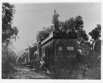 Halls Gap & Grampians Historical Society
Photograph - B/W, C 1882
Occasional picnic trains took large groups of visitors to the base of the mountain range & sometimes as far as the quarry. Other journeys terminated at Fyans Creek station on the south side of Mt Dryden. Most trips were Sunday School & Church outings, some on the annual Good Friday picnic. Spring was also a popular timePhoto shows train at siding. Man standing on engine roof with bucket in hand; woman in right hand corner of photo looking on; passenger looking out of open doorway. R333 written on back of engine car. Engine turned back to fronttransport, trains -
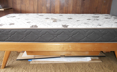 Robin Boyd Foundation
Furniture - Bed
This is Suzy Boyd's bed. The beds of both Suzy and Penleigh Boyd (item F086) seem to be made of mountain ash. An advertisement in the Argus (Wed 7 November 1956) by Myer Emporium for the "Meyer Robson" Studio Divan looks to be the same as these beds in Walsh St. This is a new mattress. Suzy's original mattress was 'Royal Slumber Sleeper'.Single bed with timber frame and mattress and sliding timber drawer attachedwalsh st furnishings, robin boyd -
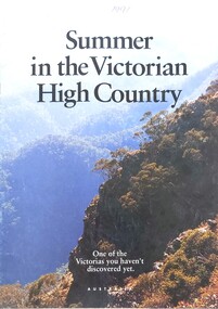 Falls Creek Historical Society
Magazine - Summer in the Victorian High Country 1991
This brochure is part of the marketing program for the Victorian High Country in Northeast Victoria. It contains information on several locations. The cover bears an image of the mountains, the title and the slogan "One of the Victorias you haven't discovered yet". The brochure was jointly sponsored by the Victorian Tourism Commission, the RACV, the Alpine Resorts Commission Victoria and the Department of Conservation and the Environment.This item is important as it documents promotions for a popular region of Victoria surrounding Falls Creek.An A4 sized magazine titled 'Summer in the Victorian High Country" featuring images and text.victorian high country, falls creek marketing