Showing 3153 items matching "miles"
-
 Alfred Hospital Nurses League - Nursing History Collection
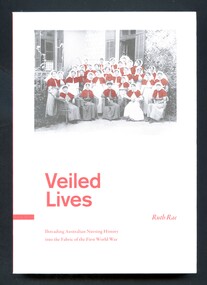
Book - Illustrated Book, Ruth Rae 1957, Veiled Lives: threading Australian nursing history into the fabric of the First World War, 2015
In this book the author considers the family and social lives, civilian nurse training, military nursing experiences and premature deaths of qualified Australian nurse who endured the horrors of the 1914-1918 War. Veiled Lives also uncovers the impact of their absence on the nurses' families, friends, colleagues, communities and their profession.illustrated book with white front and back covers and red spine. The front cover has a red, black and white photograph of a group of nurses: group portrait if the matron and nursing staff of the 1st AGH with Matron Nellie Miles-Walker (centre front). Title and author's name are printed in red below this photo. Abbreviated title and author's name printed in white on the spine. Back cover has abbreviated title printed in red and a summary of the book printed in black.non-fictionIn this book the author considers the family and social lives, civilian nurse training, military nursing experiences and premature deaths of qualified Australian nurse who endured the horrors of the 1914-1918 War. Veiled Lives also uncovers the impact of their absence on the nurses' families, friends, colleagues, communities and their profession.world war 1914-1918, military nursing-australia, australia army-nurses, nurses -
 Clunes Museum
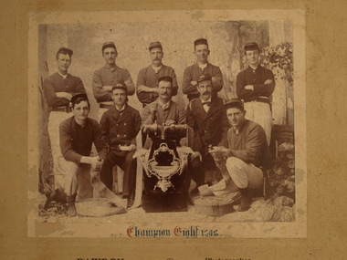
Photograph, CHAMPION EIGHT 1902, 1902
CLUNES FIRE BRIGADE WON THE CHAMPION EIGHT COMPETITION IN 1902. THEY WERE AWARDED A TROPY WHICH IS A FLUTED VASE ON A SILVER BASE WITH ORNATE FRAME HOLDING VAS AND TWO FLUTED TRUMPET VASES EITHER SIDE..1 COPY OF PHOTOGRAPH OF CLUNES FIRE BRIGADE CHAMPION EIGHT 1902 TEAM MEMBERS : W. POWER, B. HAWKS, M.C. CROWTHERS, G. PEARCE, ? MCKENZIE, F. MILES, G. HAY, ? MCKENZIE, P. KEMPSON, B. FEATONBY. .2 SEPIA COPY OF ABOVE, WITH INSCRIPTION ''CHAMPION EIGHT 1902'' .3 COPY OF SEPIA PHOTOGRAPH .4 ORIGINAL BLACK AND WHITE PHOTOGRAPH MOUNTED ON CARDBOARD .5 SEPIA COPY OF PHOTOGRAPH IN AN ORNATE WOODEN FRAME .4 CHAMPION EIGHT 1902 - BAWDEN PHOTOGRAPHER CLUNESlocal history, photography, fire brigade, trophy, champion eight, 1902 -
 Victoria Police Museum
Photograph (uniform, female)
Back row (l to r): Ellen Jagoe, Selma Snell, Jean Coutts, Flo Miles. Front row (l to r): Jane Ford-Lloyd, Elva Carr, Chief Commissioner Duncan, Anne Palmer, Jessie ArnottGraduation photograph from 1950 showing the full complement of uniform of Victorian women police. Chief Commissioner Duncan is seated in the centre of the front row.police women, uniform, duncan, chief commissioner, carr, elva, graduation -
 Clunes Museum
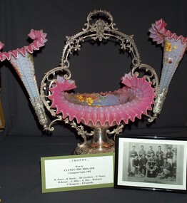
Memorabilia - TROPHY, EPERGNE
Trophy won by the Clunes Fire Brigade "Champion Eight" in 1902. Team members W. Power, B. Hawks, Mr. Crowthers, G. Pearce, McKenzie, F. Miles, G. Hay, McKenzie, P. Kempson, B. Featonby.1 1890's Plated American made table centerpiece Epergne with central glass bowl and matching pair of floriate trumpet vases with scalloped ornate pink borders .2 Framed Photograph of firemen involved in championship . Championship 8 1902Nilclunes fire brigade, trophy, epergne, glass -
 Ballarat Tramway Museum
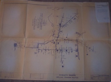
Drawing, State Electricity Commission of Victoria (SECV), "Schematic Diagram Geelong Tramway Routes", 1953
The drawing is very detailed showing streets, cross streets, route, loops, schools, woollen mills, ovals, sections, track phones, stops, route and track miles, pedestrian crossings, railway stations and notes on through route mileages.Print of a drawing showing in very good detail, the schematic layout of the Geelong Tram system. Produced in 1953 and sent to Tramway Supt. in 1970 for his records. Gives very detailed information on another SEC tramway system.Dyeline print of SEC Drawing No. GE-T13-8829, titled "Schematic Diagram Geelong Tramway Routes". Drawing prepared 27/8/1953. Stapled to the top right hand corner of the sheet is a SEC memo form from finance section, distribution services to the Dept. Tramway Superintendent, Ballarat, dated 6-2-1970 forwarding Les Denmead the plan. Was unstapled during the 1/2008 copying of the drawing. On top right hand corner of drawing, "Ballarat Tramway Preservation Society Catalogue No. 605" in ink and on rear in two places "Geelong Tramways" and one "BTPS 605"geelong, map, track layout, tram stops -
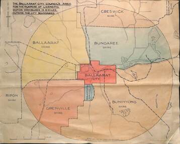 Ballarat Tramway Museum
Drawing - Map, "Licensing motor omnibuses", c1940
The drawing or map shows the 8-mile radius that applied to the City of Ballaarat's powers for the licensing of passenger Motor buses. Shows the boundary of the City of Ballaarat, Borough of Sebastopol, Shires of Ballaarat, Bungaree, Buninyong, Creswick, Glenlyon, Grenville and Ripon. Demonstrates a plan that shows the limits of the City of Ballaarat's power to license passenger buses.Drawing - dyeline print and colouredbuses, licensing of buses, shires, maps, city of ballaarat -
 Buda Historic Home & Garden Castlemaine
Artwork, other - Bookmark, 1915
This bookmark may have belonged to, and was possibly made by, Miss Mary Leviny, the eldest of the Leviny sisters, who was a founding member of the Castlemaine Red Cross. This bookmark was found in the book 'Half Mile Down' by William Blake (Reg. No. 1081).A rare, intact memento of Australia Day in the form of a gum leaf made into bookmark. It was possibly sold as a fundraiser for the newly formed Red Cross in Castlemaine to aid the war efforts abroad during World War One.Hand-paInted bookmark made from a gum (eucalyptus) leaf. P Gum leaf with stem. Inscribed in white "Australia Day/1915" and painted with a red cross. A length of narrow ribbon, red, white and blue has been inserted, folded through a slit near the base, used as a book mark.Inscribed in white "Australia Day/1915"leviny family, gum leaf, bookmark, red cross, australia day, 1915, buda, castlemaine, world war one -
 Melbourne Tram Museum
Document - Historical list of track length for Melbourne tramways - 1910 to 1982, 1982
List provides the miles or kilometres of Melbourne tramlines length for the MMTB - Cable, Electric both double line and single line, and horse tramways from 30/9/1910 to 30/6/1982. The Victorian Railways lines are excluded. Yields information about the Melbourne tram lines and their total length to 1982.Two page A4 photocopy stapled in top left hand corner.tramways, mmtb, melbourne, tram tracks, length, cable tramways, horse tramways, electric tramways, single line -
 Lakes Entrance Historical Society
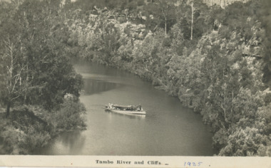
Postcard, W S Vogt Bairnsdale, Tambo River Swan Reach Victoria, 1925 c
Note with photograph says This is a view of the Tambo River about a mile and a half up from where I am staying. The river here is narrow owing to cliffs with love from Arthur. Maybe Archie MacArthers boat GowrieSepia toned postcard of a passenger launch on the Tambo River below the cliffs upstream from Swan Reach Victoriaboats and boating, rivers, tourism -
 Bendigo Historical Society Inc.
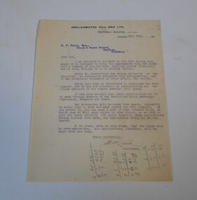
Letter - Kelly and Allsop collection: Amalgamated Hill End
Situated 150 miles from Sydney and 50 miles from Bathurst, Hawkin's Hill mining leases had produced good returns in the 1860's and 70's. However, a lack of working capital meant that many of the mines operated by up to 17 different companies petered out. About 1886 efforts were made to consolidate these claims but insufficient funding could be found. With the renewal of an offer of a government subsidy and the sale of shares, has allowed the purchase of these old claims and their infrastructure. Exploration has shown that these old mines still contained payable amounts of gold. Thus the formation of the Amalgamated Hill End Company.Typewritten letter dated 2nd February 1911. The letter is from the Amalgamated Hill End Ltd signed by the secretary, addressed to M.P. Kelly Esq. stock and share broker, Bendigo. The letter advises of the upcoming float on the stock market of the Amalgamated Hill End Mines. The float is for 500,000 shares at four shilling each. Copies of the prospectus will be sent once available.A lot of sums in pencil on front and backamalgamated hill end mine, shares -
![Poster, Greensborough Athletic Club: Carnival [1968], 26/03/1968](/media/collectors/4f729f5697f83e03086015b8/items/64edb98e432704ab169dc92c/item-media/64edb9ec432704ab169dd75e/item-fit-380x285.jpg) Greensborough Historical Society
Greensborough Historical SocietyPoster, Greensborough Athletic Club: Carnival [1968], 26/03/1968
Poster advertising the Greensborough Athletic Club's Carnival held n 26 March,1968. Activities included the Greensborough Gift, Diamond Valley woodchop with Jack O'Toole and a One Mile Handicap. The Carnival was held in conjunction with the Greensborough Football Club.Advertising poster, colour, laminated and framed.greensborough gift, greensborough athletics club -
 Orbost & District Historical Society
lamp, Early 1800's
This lamp was used on the first coach from Cunninghame (Lakes Entrance) to Orbost. The coach started for Orbost from Roadknight's, near Cunninghame (Lakes Entrance), at 7.30a.m. The journey was 32 miles and took eight hours. The fare was 25 shillings return. This item is an example of an item used in the time of horse and carriage transport.An old black kerosene coach lamp with a large glass lens. The glass is cracked. It has a metal stack with a handle.lamp lighting kerosene coach -
 Myrtleford and District Historical Society
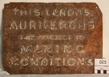
Gold Mining Sign
This sign was required to be displayed in the vicinity of gold mining sites. Myrtleford district was known to have had 100 sites within a ten mile radius of the town; the sign was recovered by Charlie McFadyen, a local prospector and fossicker, of some 60 yearsThe sign relates to local gold mining activity, a key source of wealth and employment from 1854 to the late 19th century. Such signs continued to be in use during the period between World War 1 and 2,including the period of the Great Depression.Tin rectangular mining sign embossed with a warningInscription: "THIS LAND IS AURIFEROUS AND SUBJECT TO MINING CONDITIONS"auriferous mining -
 Stawell Historical Society Inc
Book - Guide Book, The Emigrant's Friend
Faxsimile Reprint of 1848 booklet printed in London J. Allen warwick, Paternoster Row: D. Francis Mile End Road. May be had of all Booksellers. Inlcudes what Emigrant must provide at minimum when on passage to the colonies.Paper Back, Fawn cover: Brown print Seals of Australia, New Zealand, Van Dieman's Land, and the Seal of Swan River.Seal of New Zealand Seal of Australia [Picture of Seal] [Picture of Seal] The Emigrants friend or Authentic Guide to South Australia Including Sydney: Port Philip or Australia Felix: Western Australia, or Swan River Colony: New South Wales: Van Dieman's Land; and New Zealand original published in London in 1848. Recreated by Reader's Digest Sydney [Picture of Seal] [Picture of Seal] Seal of Van Dieman's Land [Seal of Swan River] -
 Sunbury Family History and Heritage Society Inc.
Photograph, 2001
The water tank stands on Sunbury Railway station and was in use when steam trains were used along Bendigo line. After travelling 37 kms (25 miles) from Melbourne, it was necessary for the trains to replenish their water supply at Sunbury. The presence of the water tank at Sunbury Station is an indicator that it was one of the major stations along the Bendigo line. A coloured photograph of a rectangular water tower. The first level is a brick construction and the metal tank is on top of it. water tanks, railway stations, steam travel -
 Surrey Hills Historical Society Collection
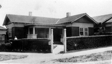
Photograph, No 1 Blackburn Street
The house was built c1920. The first occupant was Mr George Leslie Miles, a grocer, also resident at 5 Empress Road. He was followed by Mr Charles Frederick Barrow, an electrical mechanic, who later moved to 316 Canterbury Road.A black and white photograph of a Californian Bungalow style house in a corner location. A fence with a neat hedge border two sides of the property. Gate posts are at the corner of the property.1920, surrey hills, blackburn street, bedford avenue, mr charles frederick barrow, mr george leslie miles -
 Lakes Entrance Historical Society
Photograph, Lakes Post Newspaper, 1992
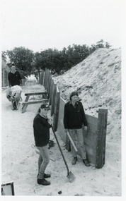
Article appeared in Lakes Post 28 October 1992, 'At work on the new retaining wall leading to 90 Mile Beach, staff from the Department of Conservation and Natural Resources, (L-R) Ken Judd, Jason Bice and David Harper'.Black and white photograph of three workers, building pathway and retaining walls through the sand dunes. Coastal banksia in background. Lakes Entrance Victoriawaterfront, parks, room display -
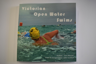 Warrnambool and District Historical Society Inc.
Book, Don Warner, Victorian Open Water Swims, 2021
This book by Don Warner contains information on present day open water swims in VictoriaThis is paper back book of 128 pages. The front cover has a colour photograph of a swimmer and white printing. The spine has black printing and the back cover has a colour photograph of swimmers and black printing. The pages contain printed text and colour photographsnon-fictionThis book by Don Warner contains information on present day open water swims in Victoriaswimming races in warrnambobol, open water swimming -
 Ringwood and District Historical Society
Picture, Framed picture of Ringwood Borough Councillors 1928-1929, 1929
Prepared by Talma & Co, Melbourne. Hung in council chambersFramed picture of members of the Ringwood Borough Councillors 1928-1929 +Additional Keywords: Cr. A. Blood / Cr. Wm. Mackindlay J.P. / Cr. A.T. Miles J.P. / Cr. R.G. Wilkins / Cr. J.B. McAlpin J.P. Mayor / Cr. J.K. McCaskill / Mr. W.T. Jenkin - Rate Collector & Valuer / Mr. A.F.B. Long - Town Clerk / Mr. A.H. McKibbin - Health Inspector / Dr. A.T. Langley - Health Officer / Mr. F.R. Lucas - Borough EngineerPresented by Cr. J.B. McAlpin, JP to the Ringwood Borough Council. -
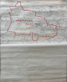 Federation University Historical Collection
Map, Ballarat Municipalities and City Boundary
Piece of linen attached at top and bottom with wooden rails. Top half of linen has a paper map of Ballaarat Province and Surrounding Municipalities directly attached to it and reads 'Ballaarat Province' in red ink which outlines the greater Ballarat area with surrounding municipalities shown in blue. Scale is '8 miles to 1 inch'. Bottom half is drawn directly onto linen and depicts Ballaarat City Boundary including street names. 'Scale about 20 chains to 1 inch'.ballarat electorate, map, ballaarat province, ballarat to buninyong railway -
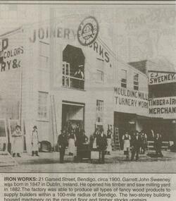 Bendigo Historical Society Inc.
Newspaper - JENNY FOLEY COLLECTION: IRON WORKS
Bendigo Advertiser ''The way we were'' from 2000. Iron works: 21 Garsed Street, Bendigo, circa 1900. Garrett John Sweeney was born in 1847 in Dublin, Ireland. He opened his timber and saw milling yard in 1882. The factory was able to produce all types of fancy wood products to supply builders within a 100-mile radius of Bendigo. The two-storey building housed machinery on the ground floor and timber stocks upstairs. The clip is in a folder.newspaper, bendigo advertiser, the way we were -
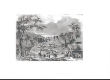 Bendigo Historical Society Inc.
Photograph - RAILWAYS COLLECTION: PHOTO OF A SKETCH OF 'JACKSON CREEK VIADUCT OPENING
Railways collection -photo of a sketch of 'Jackson Creek Viaduct Opening (Courtesy ARHS Vic Division Inc.)'. The Jackson Creek Viaduct is a bridge about 24 miles from Melbourne and is 80 feet high being constructed of Footscray Bluestone piers and abutments and wrought iron girders. The girders were made in England and delivered to the colony by the time the the piers were ready to receive them. The laying of the foundation stone of this viaduct marked the opening of the line to Sunbury on 13 January 1859.photo, 'jackson creek viaduct -
 Bendigo Historical Society Inc.
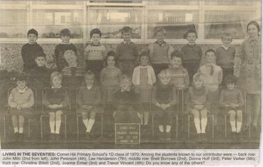
Newspaper - JENNY FOLEY COLLECTION: LIVING IN THE SEVENTIES
Bendigo Advertiser ''The way we were'' from Saturday, June 18, 2005. Living in the seventies: Comet Hill Primary School 1D class of 1970. Among the students are, back row: John Milic (2nd from left, John Peterson (4th), Lee Henderson (7th). Middle row: Brett Burrows (2nd), Donna Huff (3rd), Peter Varker (5th). Front row: Christine Billett (2nd) Joanne Ermel (3rd) and Trevor Vincent (4th).newspaper, bendigo advertiser, the way we were -
 University of Melbourne, Burnley Campus Archives
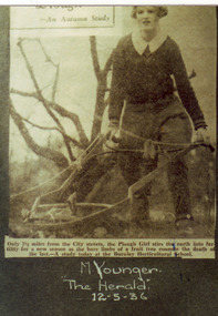
Photograph - Colour print, The Herald, An Autumn Study, 1936
Photograph made by A.P. Winzenried as possible illustrations in, "Green Grows Our Garden." Colour prints. Copy of 2 newspaper articles made by A.P. Winzenried. 1. Top, "- An Autumn Study. Only 3⅟₂ miles from the City streets, the Plough Girl stirs the earth into fertility for a new season as the bare limbs of a fruit tree connote the death of the last - A study today at the Burnley Horticultural School." Female student using a horsedrawn plough in the Orchard. 2. A female student holding a bull wearing a head stall and a rope attached to a ring in its nose.Handwritten, "M. Younger. "The Herald." 12-5-36. Bottom, handwritten, "J. Wakeford & Vida's Boy. "The Herald." 12-5-36."a.p. winzenried, green grows our garden, plough, female students, fruit trees, j. wakeford, m. younger, students working outside, horse-drawn plough, bull, orchard, vida's boy -
 Whitehorse Historical Society Inc.
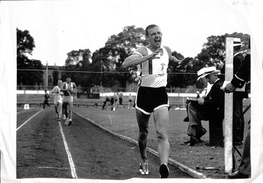
Photograph, Walk Championship, 1966
Photograph of 15th Victorian two mile walk championship in 1966. Won by Robert (Bob) Gardiner in 13 min 57.4 sec. Bob was a member of Collingwood Harriers Club. Cinder track replaced by synthetic track at Olympic Park, Swan Street, Melbourne Railway Building where Vodaphone Arena now located. Gardiner, Robert - No 1 Lucas, Alan - No 15- Coburg Harrier Henderson, Jim - No 6- University Athletic Club O'Dwyer, Jim - Finish Recorder| Olympic Parkgardiner, bob, lucas, alan, henderson, jim, o'dwyer, olympic park -
 Ballarat Tramway Museum
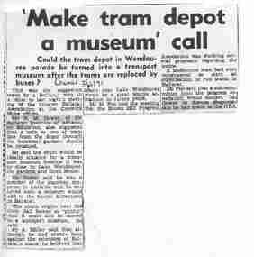
Document - Photocopy, The Courier Ballarat, "Make tram depot a museum' call", 3/04/1971 12:00:00 AM
Yields information about the formation of the BTPS in 1971 and some of the people who attended meetings etc. and about the closure of the Ballarat tramway system.Photocopy of a newspaper clipping from The Courier, Ballarat, 3/4/1971, titled "Make tram depot a museum' call". Reports on the suggestion at a meeting the previous night by Mr. N. M. Gower suggested that the tram depot and one or two miles of track be kept. Meeting of the Greater Ballarat Association. Also quotes Melton Foo of the Brown Hill Progress Association. Parts of the cutting have been highlighted in pink highlighter pen. Cr. A. Millar also quoted.trams, tramways, museum establishment, lake wendouree tramway, closure, btps -
 Ballarat Tramway Museum
Slide - 35mm slide/s, Graham Evans, Apr. 1972
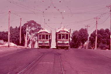
White cardboard mount, 35mm slide, from the Association of Railway Enthusiast's film strip titled "Provincial Tramway Film Strip" of a Bendigo Nos. 26 (Quarry Hill) and 25 (Eaglehawk) at Jobs Gully Loop. The film strip notes (Reg. Item 2560), provided the following caption details: "Bogie cars 26 & 25 meet at Jobs Gully loop about a mile from the terminus. Apr ' 72 (Graham Evans)" See image btm2595p.tif for high level scan of image. Stamped on base of slide "11805" and written in ink on top edge "26 & 25 Jobs Gully Eaglehawk"tramways, trams, are, film strip, jobs gully, eaglehawk, tram 26, tram 25 -
 Ballarat Tramway Museum
Document - Letter and Envelope, Mrs. R. L. Butler, 20/03/1974 12:00:00 AM
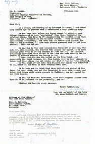
Yields information about the plaque that was fitted to tram 27 when it completed 1,000,000 miles.Letter and associated envelope - copy of correspondence between Mrs R. L. Butler and M. Calnin President of the BTPS regarding the original plaque that belonged to No. 27 - (the Million Mile plaque) on behalf of the late Adam Balloch and family. Backgrounds the history of the object. Has a note typed on the bottom of the foolscap paper re subsequent events and on the rear of the letter regarding its size. Envelope has a note typed on the front about the correspondence contents. See Reg item 64278 for the following correspondence.trams, tramways, letters, million miles, plaques, btps -
 Bendigo Historical Society Inc.
Document - IAN DYETT COLLECTION: AUCTION CATALOGUE - UPPER BETHANGA MINE
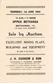
Auction catalogue for a sale on 1st June, 1944 at the Mine Upper Bethanga, Bethanga, Vic. (16 miles from Albury) of Mining Plant, Buildings and Equipment. Notice in the front of the catalogue mentioning buyers had to obtain permission from the Director of Machine Tools and Gauges to make purchases of Machine Tools and Allied Equipment at an Auction Sale. J. H. Curnow & Son were the auctioneers. Contains a description of some of the machinery and buildings. The Cambridge Press were the printers of the catalogue.business, auctioneers, j h curnow & son pty ltd, ian dyett collection - auction catalogue - upper bethanga mine, j h curnow & son, j l jamieson, w g wedd, the cambridge press -
 Bendigo Historical Society Inc.
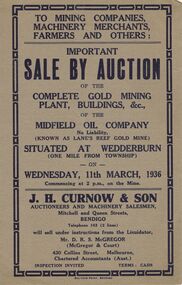
Document - IAN DYETT COLLECTION: AUCTION CATALOGUE - MIDFIELD OIL COMPANY (KNOWN AS LANE'S REEF GOLD MINE)
Grey covered auction catalogue with dark blue printing for a sale of the Complete Gold Mining Plant, Buildings, &c. of the Midfield Oil Company No Liability (Known as Lane's Reef Gold Mine), situated one mile from the Township of Wedderburn. Sale was held on the 11th March, 1936 under instructions from the Liquidator, Mr. D. R. S. McGregor (McGregor & Court). J. H. Curnow & Son were the auctioneers and the catalogue was printed by Boltons Print, Bendigo.business, auctioneers, j h curnow & son pty ltd, ian dyett collection - auction catalogue - midfield oil company no liability (known as lane's reef gold mine), j h curnow & son, mr d r s mcgregor, mcgregor & court, boltons's print bendigo