Showing 1811 items matching "planning and development"
-
 Melbourne Tram Museum
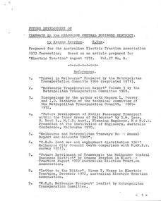
Document - Report, Graeme Breydon, "Future Development of Tramways in the Melbourne Central Business District", Apr. 1973
Six paged duplicated paper or report titled "Future Development of Tramways in the Melbourne Central Business District", by Graeme Breydon, presented to the AETA 1973 Convention, based on an article prepared for the August 1972 issue of Electric Traction. Has references, looks at proposals for underground part of the Swanston St tramway, alternatives for flinders St and a Yarra crossing, St Kilda Road issues, William St, CBD problems and travel issues, shortcomings of proposals, alternatives, Flinders Gate interchanges, associated track improvements, cost benefit ratios, comments and conclusions. 2nd copy contains within a brown manila quarto sized folded marked "Tramways in the Melbourne. Central Business District" G. Breydon (Aug. 1972). See also Reg Item 3069 and 2812 for further references. .2 - letter - c Jan 1973 - carbon copy of a Letter to the Editor for response to a letter in Electric Traction Dec. 1972 responding to H. Moses and making specific comments. .3 - letter - 29/1/1973 to Graeme Breydon from the Ian Cooper of the AETA responding and accepting an offer of Graeme to present on the Board's plan for the forthcoming AETA Canberra Conference in April 1972. .4 - Report - 17 Quarto pages, stapled on the left hand side titled "Future Development of Melbourne Tramway System, with particular reference to possible improvements to the fixed plant of the Central Business District", written by Graeme Breydon, dated Jan. 1972. Refers to the 1962 report of Risson, and scheme presented to Council, Has hand drawn maps of the central area of Melbourne, Looks at the background, traffic issues, proposed underground loop, employment distribution, an extension to Elisabeth St, reversing loops, St Kilda Road and comments on the MMTB proposals. Refers to a paper delivered by D Lees, MMTB Planning Engineer, Swanston St underground proposal,on outside of the 2nd copy, and on top right hand corner of paper AETA Library mark "4E11"trams, tramways, mmtb, melbourne, traffic control, swanston st, st kilda rd, elizabeth st, bourke st, aeta, transportation, underground tramways -
 Kiewa Valley Historical Society
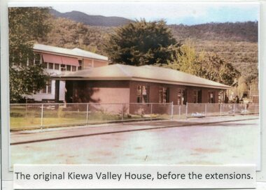
Photographs- Kiewa Valley House (before and after extensions) & Tawonga District General Hospital- Set of 6 colour photographs
The establishment of Kiewa Valley House, was a significant victory for residents and senior citizens in the Kiewa Valley district. Plans were laid in the mid 1970’s and a proposal was formulated for a 12 bed unit nursing home to be attached to the Tawonga District General Hospital. The need for an aged care facility in Mount Beauty was prompted by recognition of the high ratio of senior citizens residing in the area. At the time residents had to travel to Beechworth, Wangaratta or Wodonga for care. On June 6th, 1980, an appeal to finance a 12 bed nursing wing was launched at a public meeting in Mount Beauty The Hospital and Charities Commission’s development board finally approved the application for government funds to build the 12 bed nursing home in early 1981. The official opening of the nursing home was on March 6th, 1985. Opening of the lounge extensions occurred in May, 1993 Many local residents have taken advantage of facilities at Kiewa Valley House when they became unable to manage independently in their own homes. This has meant they did not have to face the stress of leaving the area and being separated from their local family and friends. Many SEC workers and their families have been residents of Kiewa Valley House over the years.Set of 6 colour photographs of Kiewa Valley House and original Tawonga District General Hospital in Mt Beauty 1 Kiewa Valley House, before extensions, with old weatherboard hospital in background 2 & 3 Official opening of Kiewa Valley House. 4 & 5 Gardens between Kiewa Valley House and Hospital 5. Kiewa Valley lounge extension 1. The original Kiewa Valley House, before extensions 2. No markings 3. No markings 4. View of the gardens between the weatherboard hospital and Kiewa Valley House 5. Walkway between Hospital & Kiewa Valley House 6. Kiewa Valley House Lounge Room extension tawonga district hospital, kiewa valley house, mt beauty district hospital -
 Eltham District Historical Society Inc
Photograph, Fay Bridge, EDHS Heritage Excursion, Edendale Farm, 5 May 2018
May Excursion – Edendale Environs Edendale Community Environment Farm in Gastons Road, Eltham now operates as Nillumbik Council’s environmental centre. The historic homestead has undergone a significant restoration and there is on-going development of the site consistent with its community education purpose. The house and the gateway sculpture “The Fences Act” are covered by a Heritage Overlay in the Nillumbik Planning Scheme. Our May excursion will comprise a walk through the farm property and will radiate to other nearby places of historic interest. These will include the site of the Eltham North Adventure Playground to discuss its history and destruction by fire (see page 1 article). Also nearby is Colemans Corner where the early road system has undergone some unusual changes. If time permits we may visit some other nearby places of interest. - EDHS Newsletter No. 239 April 2018fay bridge collection, 2018-05-05, edendale community farm, edendale farm, eltham district historical society, heritage excursion, activities -
 Kew Historical Society Inc
Photograph - 264 Cotham Road, 1988
The dwelling is representative of the development of the Georgian Revival style in the 1920s and 30s and its popularity amongst the upper-middle classes as a result of the work of William Hardy Wilson and Professor Leslie Wilkinson. It is of importance as a fine and largely intact designer/builder example of the Georgian Revival style, with American Georgian Revival influences. The dwelling embodies the principal characteristics of the style. American Georgian Revival influences are noted in the deep eaves with modillions, central broken pediment, brick quoins and presentation of the central porch. The garden wall, with arched opening, in the side setback appears to be an early or original landscape feature, based on the comparable brick work detail construction with that of the house. Considering this, it is the only early landscape feature extant which assists in providing some understanding of the original landscape layout of the property. (Criteria D and E) (Boroondara Planning Scheme)Colour photographic positive of 264 Cotham Road, Kew. The residence was constructed in 1931 for the Howitt family. 264 Cotham Road, Kew (HO813) is an individually listed building of significance under Amendment C294 of the Boroondara Planning Scheme. 264 cotham road -- kew (vic.) -
 Eltham District Historical Society Inc
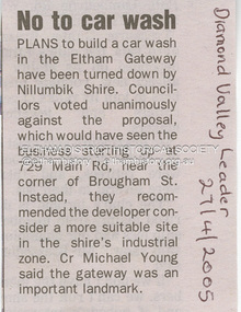
Document - Property Binder, 729 Main Road, Eltham
Newspaper article: Diamond Valley Leader, 27 April 2005, No to car wash. Letter 25 July 2005 from Minter Ellison Lawyers attaching VCAT notice of adjournment. Letter 5 September 2005 re Application for review of Application for Review P1036/2005. Letter 6 September 2005 from Apex Building Design Studio to Minter Ellison Lawyers re carwash development. Newspaper article: Diamond Valley Leader 20 February 2007, Gateway 'blob' bid fails test, Nillumbik Council rejected plan for 3 story building, 12 offices, ship, 8 homes. Notice of Decision to Refuse to Grant a Permit, Application 191/2023/02P, Nillumbik Shire Council, 4 Oct 2023 Newspaper advertisement: Leader Associated Newspapers, Eltham Centenary Supplement, March 30, 1971, Mobil Service Centremain road, eltham, property, businesses, carwash, apex design studio, eltham gateway, minter ellison lawyers, mobil service centre (eltham) -
 Eltham District Historical Society Inc
Film - Video (DVD), Nillumbik Shire Council, Edendale Farm Community Environment Centre: History, c.2009
EDENDALE FARM Edendale Farm is Nillumbik Shire Council's environment centre situated in Gastons Road, Eltham between the railway and the Diamond Creek. The homestead on the property was built in 1896 and is of historical significance, being the subject of a Heritage Overlay under the Nillumbik Planning Scheme. The Edendale property was originally part of an extensive land purchase in 1852 from the Crown by pioneer Eltham farmer Henry Stooke. He initially purchased 51 acres and later expanded his holdings by purchasing another three adjacent Crown allotments extending northerly from Josiah Holloway's Little Eltham subdivision. Despite clearing the land, Stooke did not build on this property, choosing to live on his property "Rosehill" at Lower Plenty. In 1896 Thomas Cool, Club Manager of the Victoria Coffee Palace in Melbourne purchased 7 acres of the original Stooke land and built the house now known as Edendale. Cool did not farm the land, instead using it as a gentleman’s residence, retiring to Eltham at weekends. In 1918 he purchased an additional 7 acres but in 1919 he sold the property. Later owners included J.W. Cox, the Gaston family and D. Mummery. In the 1980s the Eltham Shire Council purchased the site for use as a Council depot, but this use did not proceed. Subsequently, it was used as the Council pound. The Edendale Farm Pet Education and Retention Centre was established in the summer of 1988/1989 and was set up to replace the existing dog kennels with a high standard pet retention centre. The design style of the building was established to compliment the features of the existing house. It was equipped with 10 retention pens, a veterinary room and a pet education area where school children and other interested parties learnt about pet care procedures. It was later developed into a community farm and was run by an advisory committee and in 2000 it became an Environment Centre. In early 2006 an advisory committee was established for the development of a master plan for future development at Edendale Farm. The committee included Russell Yeoman, a former long-time shire planner and founding member of the Eltham District Historical Society. At the time of filming the Master Plan and future for Edendale was about continuing to develop Edendale as a centre of environment learning and looking at expanding displays and school program, running a lot more of life-long learning and workshops around sustainable living.edendale community farm, eltham, gastons homestead, gastons road, shire of nillumbik, video recording -
 Eltham District Historical Society Inc
Photograph, Frank Stokes with daughters Dorothy (left) and Beryl (right) at Stokes Orchard, Nyora Road, Eltham, 1944, 1944
Frank Stokes first traveled to the district by train in 1944 to find land with the intention to establish an orchard. By chance he met Arthur Bird of Bird Orchard (bounded by Pitt Street, Eucalyptus Road and Wattle Grove) and they got talking over their common interest. Arthur put Frank up for the night and pointed out the land, part of Crown Allotment 15, Section 5, Parish of Nillumbik (CA15) somewhat diagonally opposite Bird Orchard. Frank bought the land and for the next two years would travel by train from Melbourne to Eltham every weekend establishing Stokes Orchard and building a home for his family, which they eventually moved into in 1946. In the mid 1970s the Shire of Eltham divided the orchard up into numerous rate-able parcel lots, which became affordable for Frank. As a consequence Stokes Orchard was turned into a housing development by Macquarie Builders and marketed as the Stokes Orchard Estate in two stages; Stage 1 encompassing Scarlet Ash Court, Ironbark Close and Peppermint Grove bounded by Nyora and Eucalyptus roads c.1976 and Stage 2 encompassing Stokes Place, Orchard Way, The Crest and The Lookout bound by Nyora and Diosma roads c.1979. The development of Orchard Way, The Crest and The Lookout did not proceed as planned due to the lack of the sewer along Diosma Road and so many of the proposed lots were incorporated into five-acre parcels instead.Representative of the orchard growing areas of ElthamDigital file only - Digitised by EDHS from a scrapbook (containing commercially printed photos of digital scans) on loan from Beryl Bradbury (nee Stokes), daughter of Frank Stokes.1944, beryl bradbury (nee stokes), beryl bradbury (nee stokes) collection, dorothy stokes, eltham, frank stokes, nyora road, stokes orchard -
 Eltham District Historical Society Inc
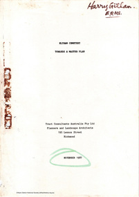
Document - Report, Tract Consultants Australia Pty Ltd, Eltham Cemetery: Towards a Master Plan, Nov 1987
BACKGROUND The Eltham Cemetery is of historic significance to the Eltham area. The Trust was established in 1858 and has administered and maintained the cemetery from that date right up to the present. Among the more noteworthy graves is that of Sir William Irvine, a former State Premier and Chief Justice of Victoria. Eltham Cemetery is surrounded on three sides by urban development. Montsalvat Artists Colony adjoins the remaining (eastern) side. A Joint Select Committee of Parliament called the “Mortuary Industry and Cemeteries Administration Committee" (MICA) enquired into the land requirements at the Eltham Cemetery in 1986. The MICA recommendations contained in its 1986 report are included in the Appendices attached to this report. Although the recommendations have not been adopted by the Government it is interesting to note that the MICA report recommended the use of the bulk of the land for cemetery purpose. In June of 1987, the Cemetery Trust was expanded to include additional members from the Eltham Community by the Minister for Health. At the same time, he instructed the Trust to resolve the land requirement issues. As a result of this Ministerial direction, Tract Consultants has been instructed by the Eltham Cemetery Trust to prepare a report addressing the issues raised in the Minister's letter (see Appendix 1) to the Trust. Principally, the study will examine options available for development of the Cemetery. These options will explore possible boundaries, cemetery design, vegetation, the overall environment, landscaping and financial planning for the Cemetery operations. Appendix 2 details the Cemetery Trusts Terms of Reference for the Study. Before commencing the study in detail, additional basic information was sought; viz: a) sub-soil and rock analysis; and b) feature survey by a Licensed Surveyor. The results from both exercises are included as appendices to this report. Section three includes a summary of the findings along with other analytical results. Also: Eltham Cemetery - planning bewteen 1859 to 1860; research by Alan Sheehan April 2015, collated by Harry Gilham, EDHS, April 2016 (2 pages) PROV Guide 5: Cemetery Records (8 pages), printed 7 May 2014Development of Eltham Cemeteryeltham cemetery trust, master plan, mica, montsalvat, mortuary industry and cemeteries administration committee, tract consultants -
 Vision Australia
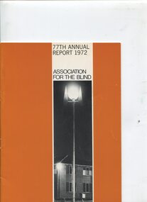
Administrative record - Text, 77th Annual Report 1972 Association for the Blind of Victoria, 1973
Articles in annual report include: branch committees, President's report, finance report, balance sheet, welfare, hospital homes, day centres, auxiliaries, volunteer service group, senior staff, life governors, formal establishment of the Low Vision Clinic which had been begun with discussions with Professor Gerard Crook in 1970 and supported for a year by the Hecht Trust, John Wilson accompanied Hugh Jeffrey, Australia's delegate on the Executive Committee for the Welfare of the Blind and IFB, businessman John Wicking joined the committee, plans for the future development of the George Vowell Centre are being formulated, Derek Nimmo entertained at multiple Auxiliary functions, the Toorak Auxiliary closed but two new ones at Kyneton and Narcoonah (Hampton), were formed, introduction of training course for volunteer workers and Mrs H.M. Lightfoot, who organised drivers for home visitor Elsie Henderson, has stepped down after fourteen years of service.1 volume of text and photographsassociation for the blind, h.m. lightfoot, john wilson, hugh jeffrey, derek nimmo, iris barnier, annual reports -
 Falls Creek Historical Society
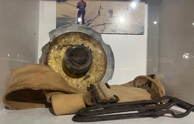
Equipment - Ski Equipment - Rope Tow Wheel, Nutcracker and Belt
FALLS CREEK ROPE TOWS Toni St Elmo brought back plans for a Hamilton rope tow from New Zealand. He had a rope tow built in the summer of 1950-51 and it went into operation the following winter. Skiers were charged 10/- per day to use it. Skiers held onto the rope with a locking device called a ‘nutcracker” attached to a webbing belt. This tow, known as the Nissen Tow, continued to operate until 1960. Bob Hymans installed a shorter portable rope tow for his guests at Skyline from 1954. Other tows included the Village Tow and the Nursery Tow. Eventually most of the tows were taken over by Alpine Developments. From 1960 onwards they were gradually replaced by T-bars and then later on by chairlifts. This belt is from the original rope tow used between 1951 and 1960 in the Falls Creek ski lifts. These items are significant because were part of the earliest rope tows constructed at Falls Creek.A canvas waist belt with leg hoops and metal joining and hook used to attach skier to the rope tow. The wheel is also a damaged component of the Rope Tow.falls creek, nissen alpine club, rope tows, toni st elmo -
 Federation University Historical Collection
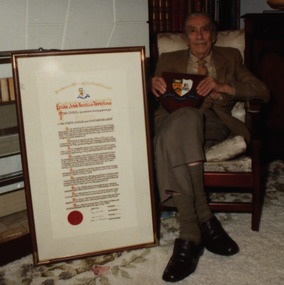
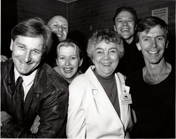
Photograph - Colour, E.J.T. Tippett receives an Illuminated Address from the Ballarat School of Mines, 1984, 18/07/1984
E.J.T. Tippett was a long term President of the Ballarat School of Mines Council.Colour photograph of E.J.T. Tippett in his home, surrounded by an framed illuminated address and a Ballarat School of Mines shield. The illumination reads: 'The Council, by resolution, hereby appoints you Patron of the School of Mines and Industries Ballarat. In so resolving, the Council is mindful of your lifelong association with the School in many capacities, and the distinguished contribution you have made to Technical and Further Education in this State. It is considered appropriate that this unique contribution be recognised by the appointment. A student at this School from 1918 to 1920, you were elected to the Council in 1934 and have maintained continuous active membership for fifty years, serving also on the Ballarat C.A.E. Council. Your remarkable service to the School included President of Council from 1940 to 1960, during which years your leadership contributed to the growth and stature of the School. As a member of the Interim Council established to plan the development of the Victoria Institute of Colleges, as a member of the COuncils of the Victoria Institute of Colleges and Monash University and as President of the technical Schools' Association of Victoria, you have given generously of your time and expert ability in the furtherance of education in Victoria. Your contribution to the development of this School has been perpetuated by the naming of the E.J. Tippett Recreation Hall in 1959 and the E.J. Tippett Library in 1978. The establishment, through your gift of an endowment fund, of the Ronaldson Brothers and Tippett Founders' Prize has provided a permanent link between the school and the early established Ballarat engineering firm of which you were Managing Director. The City of Ballarat has recognized your efforts in establishing the annual presentation of Craftsman Certificates. Your distinguished services to education has been recognized buy the State Government by awarding you the M.B.E. in 1975. The Council, Staff and Students humbly thank you for your magnificent contribution to the continuing development of this School. Given under the Common Seal of the School of Mines and Industries Ballarat, this eighteenth day of July, 1984.e.j.t. tippett, illumination, ballarat school of mines -
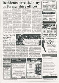 Eltham District Historical Society Inc
Document - News Clipping, Jodie Guest, Residents have their say on former shire offices, Diamond Valley News, October 16, p9, 1996
Nillumbik Commissioners used 'reserve power's to permit a controversial Shell service station and Hungry Jackls restaurant development at the former Eltham Shire Office site at 895 Main Road. More than 200 people attended the Council meeting in the public gallery and protested at the decision. 32 personal submissions were made to Council's Planning Special Committee meeting whose members vioted 3-2 against the development. The Committee consisted of the three Nillumbik Commissioners and three community members (Jim Connor, Bronwyn South and Janet Mattiske). Chief Commissioner Don Cordell, a former Shell employee excused himself from voting and the three communbity memebrs voted against the submission. The other two commissioners, Vin Heffernan and Kevin Abbott voted against it. They then immediately closed the meeting and opened a Council meeting lasting just seconds to use special reserve powers to overturn the decision. Community residents who made submissions included Russell Yeomans speaking on behalf of the Eltham Gateway Action Group and Eltham District Historical Society, Des Ryan on belaf of Eltham Senior Citizens, Angela Newhouse, others on behalf of Our Lady Help of Christians Primary School and Judge Book Village, Tom Munro, Ian Jennings, Margartet Ball a fifth generation descendant of the Shillinglaw family, one of the early settlers of the area and owner of the land that was sold to Council, Frank Burgoyne who said "there will be a lot of creaking and rumbling in the cemetery if this goes through. So many old people who have done so much for Eltham are buried up there and it is up to us to pass on what they left to the younger generation. Eltham is a beautiful spot; why louse it up?" A second article "Anger over reserve power" by Laeta Antonysen provides commentary from the three Planning Special Committee community members, former Eltham Shire Councillor Jim Connor, Bronwyn South and Janet Mattiske about the process that took place and the first time use of the spoecial reserve power to overturn the decision of the committee. Barry Rochford, Nillumbiuk CEO defends the use of the power.The demolition of the former Shire of Eltham offices and proposed sale and development driven by the Commissioners for Nillumbik Shire Council brought the community together in substantial protest at the infrigement of ratepayers democratic say in local government and ciommunity assets combined with protests about inappropraite development of Eltham's Gateway. This issue led to the formation of the Eltham Community Action Group which still operates strongly today (2023) on behalf of the community to ensure appropriate development within the community.895 main road, commissioners, dallas price homes, development application, eltham hub, hungry jacks, nillumbik shire council, re-zoning, shell service station, town planning, eltham gateway, eltham gateway action group, eltham shire offices, shillinglaw farm, shillinglaw trees, jim connor collection, dallas howgate, nillumbik planning special committee, jim connor, bronwyn south, janet mattiske, don cordell, vin heffernan, kevin abbott, russell yeomans, eltham district historical society, eltham senior citizens, des ryan, our lady help of christians primary school, judge book village, angela newhouse, tom munro, ian jennings, margaret ball, shillinglaw cottage, frank burgoyne, andrew biasci, barry rochford -
 Southern Sherbrooke Historical Society Inc.
Information folder - Madigan Cottage
The buildings are probably rare remnant examples of their type in the local area and as such are significant to the settlement of Menzies Creek. The dwelling is significant as a longstanding marker of the Madigan family who were original settlers in the area. Its retention in its site close to the road boundary expresses and maintains a connection with early settlement and rural lifestyles in Menzies Creek over the last century. The old shed is of interest as a local example of bush construction, particularly in context with the cottage and farm environs. Without the life of the farm and other elements presumed now gone, its value is lessened.Folder containing information pertaining to the history of Madigan Cottage, Menzies Creek. NB: the shed was demolished in November 2001 and the cottage burned down sometime later. Contents:- Letter, Southern Sherbrooke Historical Society to Shire of Yarra Ranges, dated 9th March 2001, re. sale of property and need for it to be included in shire's Heritage Study. -Letter, shire to society, dated 20th March 2001, reply to above. -Letter, shire to society, dated 15th May 2001, follow-up to above, requesting more information. -Letter, society to shire, dated 30th May 2001, responding to above and including a copy of information previously sent to Chris Johnston, Heritage Study consultant. -Letter, society to shire, undated, noting intention to lodge an objection to proposed application for development on site. -Letter, shire to society, dated 22nd October 2001, advising of consultation meeting. -Yarra Ranges Shire Heritage Study Place Nomination form for Madigan Cottage, prepared by Marian Matta, includes nine colour photos and diagram showing where photos were taken from. -Black and white copies of photos. -A3 copy of real estate advertisement, "Mount Evergreen Estate" dated 21st April 1924. -A3 map showing proposed resubdivision boundary variation, drawn up for Mr. P. Melville, undated but 1990s. -Copy of application for a planning permit, dated 6th August 2001, including letter by Nick Jonkers describing proposed new buildings, site map showing current vegetation, letter re. proposed removal of vegetation, subdivision plan dated March 1998, and larger scale map printed from shire website on 10th August 2001. -5 A3 sheets showing site and house plans drawn up for Mr & Mrs N. Jonkers, dated July 2001.madigan cottage, menzies creek, madigan family, mount evergreen, patrick madigan -
 Federation University Historical Collection
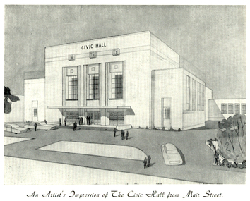
Programme, The Opening of Civic Hall, 1956, 1956
The City of Ballarat unanimously resolved to erect a Civic Hall in Mair Street in 1951. The architects, Gordon Murphy, of Melbourne, and H.L. and L.J. Coburn, of Ballarat, were commissioned in 1952. The Council constructed the foundations and footings for the building under the supervision of the former City engineer, Mr L.H. Finch, in 1953. These footings are of massed concrete. The design for the building took advantage of the cross fall of the land, providing for the Small Hall to be entered from the Doveton Street frontage through a foyer under the Main Stage, the structure is steel with brick panels, with accommodation for 1,592 persons in the Main Hall and 440 persons in the Lower Hall. The front facade faces Mair Street, set back from the building line to provide for the entrance drive-ways and kerbed gardens. Tenders were invited on a firm price basis. A young Ballarat master Builter, Walter Benbow Trahar was the successful tenderer, the contract price being 139,841 pounds. the work was commenced in 1953 and has proceeded in spite of material and labour difficulties until its completion. The following statistics are of interest:- * The foundations contained 200 cubic yards of concrete. * The constructional steel work weighs approximately 270 tons. * The reinforcing steel 47 tons. * Reinforced concrete in the structure, 1,100 cubic yards. * The approximate number of bricks in the building, 580,000. * The flooring is of selected kiln-dried hard wood and totals 40,000 lineal feet. * The dimensions of the Main Auditorium, 100ft by 86 ft, including the side promenades each 82ft by 13ft. *The Main stage, of reinforced concret with parquette finish measures 62 ft by 40ft. *The floor area of the Lower Hall is 74 ft by 38 ft, and has a stage dimensions of 40ft by 20 ft. * Each hall has independent heating and ventillating systems. Where possible the material in the building was furnished from local business houses. The public address installation, which provided for additional microphones, is on the main Stage. There is inter-communication throughout the building connecting the front office, with the bioscope box, the stages in both the large and lower halls, and the Hallkeeper's residence. Local craftsmen have completed the painting, plaster work, and the electrical installation; local produced materials being used in the construction of the buildings with the exception of the timber for the Main Floor, the roofing and the structural steel. The City of Ballarat Councillors in 1956 were Councillors N. T. Callow, F.J. Cutts, K.C. Webb, W.E. Roff, O.W. Curnow, F.T. Woodward, Allan C. Pittard, A.W. Nicholson, J.A. Chisholm, G.L. Scott, F.W. Oliver, A.D. Mason. The Town clerk was H.R. Maddern and the City Engineer was G. Murrowood. A City of Ballarat Council meeting of 25 September 2013 voted to demolish the Ballarat Civic Hall. The Council heard from nearly 50 members of the public during a marathon six-hour meeting. Councilors John Birt, Des Hudson, Amy Johnson, Josh Morris, Peter Innes, John Philips supported the motion to demolish Civic Hall. Councillors Samantha McIntosh, Vicki Coltman and Belinda Coates voted against the motion.Six page souvenir Program of citizens' entertainment on the occasion of the Opening of Ballarat Civic Hall on in August 1956. The front cover features the City of Ballarat Coat of Arms. The programme starts with a message from the Mayor, Cr Neil T. Carrow. It includes the Concert Programme directed by James H. Davey, an asrtist's impression of the Civic Hall from Mair Street, and information relative to the New Civic Hall. The programme features images of the City of Ballarat Coat of Arms, Cr N.T. Callow, , James H, Davey, and an artist's impression of the Ballarat Civic Hall. Mayor Neil Callow's Message: "To-day, our citizens witness the fulfilment of the most extensive Municipal undertaking in the City's period of recent prosperity and development. Their Hall now fills a requirement of which they have been deprived since the Coliseum building was destroyed by fire over 20 years ago. The building has been designed as an all purpose structure and I am hopeful the citizens will use it and enjoy it to its fullest extent. Your Council and its Architects have planned as broadly as possible for the benefit of all to-day and for years to come. We are proud of the work executed by a Ballaarat Master Builder whose work is a monument to the City's craftsmen. I feel I should also remind this assembly that the women of Ballaarat, back in 1951, provided funds which have been applied in the purchase of a Grand Piano and two Upright Pianos which are now installed in this building. The sincere hope of myself and your Councillors is that this Hall and its amenities will prove of immense value to the development of the cultural and artistic tastes of this community and that it will be freely used for these and many other purposes. From now on this magnificent building and its furnishings and equipment will be available to all. I strongly exhort you to use and protect it. My hope is that the citizens will, for many years to come, enjoy the amenities which it has to offer. ballarat civic hall, civic hall, architecture, finch, art deco, city of ballarat, coat of arms, city of ballarat coat of arms, callow, shugg, lemke, oates, gullan, tuuri, john, robertson, sorrell, antonio, gordon murphy, walter benbow trahar, trahar, coburn, h.l. coburn, l.j. coburn, n.t. callow -
 Bendigo Military Museum
Photograph - Co-ordinatorgraph Map Grid Production, Army Survey Regiment, Fortuna Bendigo, c1960s to 1970s
This is a set of seven photographs of map grid production using co-ordinatorgraphs at the Army Survey Regiment, Fortuna Bendigo. c1960s to 1970s. The Aristo Co-ordinatorgraph introduced in 1962 was a large heavy steel framed light table with a scribing head that moved in a XY direction using a vernier calibrated measuring scale to 0.001 of an inch. Whilst hand operated it was much quicker and accurate than manual grid and graticule calculation, plotting and scribing. Mapping PNG presented the Regiment with many challenges. WO1 Farrington and CPL John Dean developed computer software for the digitally controlled co-ordinatorgraph, the Calcomp 718 Flatbed Plotter. Much time was saved by automatically plotted cartographic grids and graticules, and automatically draw base compilation sheets complete with aerial triangulated stereo model control. This could be used for a number of maps and was the first step towards map automation. The history of co-ordinatorgraphs is covered in more detail with additional historic photographs, in pages 50 to 51 and page 88 of Valerie Lovejoy’s book 'Mapmakers of Fortuna – A history of the Army Survey Regiment’ ISBN: 0-646-42120-4. SGT Bill Boyd appearing in photo .1P reach the rank of WO1 and for 11 years was the technical warrant officer at the Detachment Army Survey Regiment located at Bonegilla, Victoria. He was awarded the OAM, the Order of Australia Medal for the development of the Flexiflow quality control system. This system comprised a series of job plans and charts linked to a task allocation to resource magnetic planning board. Using critical path analysis and task prioritisation, complex job planning was efficiently scheduled, and re-prioritisations readily made. Reproduction requirements were effectively coordinated by way of weekly courier to the Army Survey Regiment. Supervisors and technicians fully embraced the system as they could understand their role, others around them and the positive production achievements. Bendigo. See page 178 of Valerie Lovejoy’s book for more information on WO1 Boyd’s contribution to RA Svy.This is a set of seven photographs of map grid production using co-ordinatorgraphs at the Army Survey Regiment, Fortuna Bendigo. c1960s to 1970s. The photographs were printed on photographic paper and are part of the Army Survey Regiment’s Collection. The photographs were scanned at 300 dpi. .1) - Photo, black & white, c1960s, L to R: SGT Bill Boyd demonstrating Aristo Co-ordinatorgraph equipment to unidentified technicians (x3) .2) - Photo, black & white, c1960s, Aristo Co-ordinatorgraph equipment. .3) - Photo, black & white, c1960s, unidentified technician operating Aristo Co-ordinatorgraph equipment. .4) - Photo, black & white, c1960s, L to R: PTE Desi Asaris and CPL Kalen Sargent operating Aristo Co-ordinatorgraph equipment. .5) - Photo, black & white, Photo, black & white, c1970s, John Bloor operating Calcomp co-ordinatorgraph equipment. .6) - Photo, black & white, Photo, black & white, c1970s, unidentified technician operating Calcomp co-ordinatorgraph equipment. .7) - Photo, black & white, Photo, black & white, c1970s, L to R: SGT Andy Covington and SGT John Waight operating Calcomp co-ordinatorgraph equipment..7P annotated on back ‘Covington & Waight’.royal australian survey corps, rasvy, army survey regiment, army svy regt, fortuna, asr, carto, air survey -
 Federation University Historical Collection
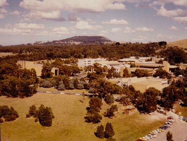
Photograph - Photograph - Colour, VIOSH: Early photograph of the Mount Helen Campus - Ballarat Institute/College of Advanced Education
Victorian Institute of Occupational Safety and Health (VIOSH) Australia is the Asia-Pacific centre for teaching and research in occupational health and safety (OHS) and is known as one of Australia's leaders on the field. VIOSH has a global reputation for its innovative approach within the field of OHS management. VIOSH had its first intake of students in 1979. At that time the Institution was known as the Ballarat College of Advanced Education. In 1990 it became known as Ballarat University College, then in 1994 as University of Ballarat. It was 2014 that it became Federation University. VIOSH Australia students are safety managers, senior advisors and experienced OHS professionals. They come from all over Australia and industry. Students are taught active research and enquiry; rather than textbook learning and a one-size fits all approach. VIOSH accepts people into the Graduate Diploma of Occupational Hazard Management who have no undergraduate degree - on the basis of extensive work experience and knowledge. In 1964 the Victorian Government announced that a committee be established to plan for the establishment of a Victorian Institute of Colleges. Eight Technical colleges would be raised to the level of university colleges. Ballarat School of Mines was on the list. Plans were also underway for the development of a new campus at Mount Helen. The Mount Helen Campus was officially opened on 30 October 1970 by the Hon Sir Nigel Bowen, Minister for Education and Science. It was at this Campus, in 1977, that VIOSH was conceived and from 1979, when the first intake of VIOSH students started, it became a significant course at Ballarat College of Advanced Education and continued to recent times.Colour photograph showing the Mount Helen Campus buildings.viosh, victorian institute of occupational safety and health, victorian institute of colleges, ballarat school of mines, university colleges, hon sir nigel bowen, minister for education and science, mount helen campus, ballarat college of advanced education -
 Glen Eira Historical Society
Article - Caulfield Park
This file has thirteen items. 1/Typed note date and author unknown, titled development in Caulfield Park, describing the statuses commissioned for the park in 1975. 2/Photocopies undated of photographs of two of the statues. 3/Article dated 19/03/1980 in the Southern Cross newspaper about Caulfield Councils frisbee and golf day at the park. 4/Invitation for Mr. and Mrs. Campbell to attend tree planting ceremony at Caulfield Park on 23/10/1988 to commemorate Raoul Wallenberg. 5/Black and white photograph, undated, photographer unknown, of lake and fountain at Caulfield Park. 6/Three colour photographs dated June 1982 of Caulfield park. 7/Photocopy of photograph of War Memorial at Caulfield Park. 8/Leaflet advertising a parade and fair at the park on 25/05/1997. 9/Two black and white photographs, date and photographer unknown, of conservatory at the park after it burnt down, possibly in the 1920’s. 10/Friends of Caulfield Park newsletter dated July 2007 concerning the council’s plans for the park. 11/Article dated 19/10/2011 from Melbourne Weekly Bayside about the conservatory and its future, includes photograph. 12/Article dated 07/05/2013 in the Glen Eira Leader concerning the council’s plans for the conservatory. Includes dot points that original glasshouse (ex-Ripponlea) destroyed by fire in 1977 and replaced by existing hothouse. 13/Article dated 23/07/2013 from Glen Eira/Port Phillip Leader about public society survey concerning the conservatory’s future.caulfield park, north caulfield, balaclava road, caulfield city council, cannizzo phillip, statues, sculpture, hawthorn road, meserow hale, campbell jack, campbell mrs., braun emil, huppert michelle, wallenberg raoul, fountains, parks and reserves, monuments and memorials, parades and processions, festivals and celebrations, greenhouses, conservatories, catherine street, st aloysius school hall, friends of the caulfield park., caulfield park pavillion, pavilions, sportsgrounds, playing fields, playgrounds, glen eira council, wilde david, pilling neil, lipschutz michael, rippon lea mansion, magee jim, lobo oscar, sounness thomas -
 Eltham District Historical Society Inc
Photograph, Frank Stokes with his mother Florence (nee West) and children, Dorothy (left), David (centre) and Beryl (right), Stokes Orchard, Nyora Road, Eltham, c.1950, 1950c
Frank's mother Florence was visiting from England at the time. Frank Stokes first traveled to the district by train in 1944 to find land with the intention to establish an orchard. By chance he met Arthur Bird of Bird Orchard (bounded by Pitt Street, Eucalyptus Road and Wattle Grove) and they got talking over their common interest. Arthur put Frank up for the night and pointed out the land, part of Crown Allotment 15, Section 5, Parish of Nillumbik (CA15) somewhat diagonally opposite Bird Orchard. Frank bought the land and for the next two years would travel by train from Melbourne to Eltham every weekend establishing Stokes Orchard and building a home for his family, which they eventually moved into in 1946. In the mid 1970s the Shire of Eltham divided the orchard up into numerous rate-able parcel lots, which became affordable for Frank. As a consequence Stokes Orchard was turned into a housing development by Macquarie Builders and marketed as the Stokes Orchard Estate in two stages; Stage 1 encompassing Scarlet Ash Court, Ironbark Close and Peppermint Grove bounded by Nyora and Eucalyptus roads c.1976 and Stage 2 encompassing Stokes Place, Orchard Way, The Crest and The Lookout bound by Nyora and Diosma roads c.1979. The development of Orchard Way, The Crest and The Lookout did not proceed as planned due to the lack of the sewer along Diosma Road and so many of the proposed lots were incorporated into five-acre parcels instead.Representative of the orchard growing areas of ElthamDigital file only - Digitised by EDHS from a scrapbook (containing commercially printed photos of digital scans) on loan from Beryl Bradbury (nee Stokes), daughter of Frank Stokes.1950, beryl bradbury (nee stokes), beryl bradbury (nee stokes) collection, david stokes, dorothy stokes, eltham, flatbed truck, florence stokes (nee west), frank stokes, nyora road, stokes orchard -
 Eltham District Historical Society Inc
Photograph, The Stokes family home blanketed with snow, corner Nyora and Eucalyptus roads, Eltham, winter 1951, 1951
Taken from outside the family home on the southest corner of the intersection of Nyora Road and Pitt Street with Eucalyptus Road. Frank Stokes first traveled to the district by train in 1944 to find land with the intention to establish an orchard. By chance he met Arthur Bird of Bird Orchard (bounded by Pitt Street, Eucalyptus Road and Wattle Grove) and they got talking over their common interest. Arthur put Frank up for the night and pointed out the land, part of Crown Allotment 15, Section 5, Parish of Nillumbik (CA15) somewhat diagonally opposite Bird Orchard. Frank bought the land and for the next two years would travel by train from Melbourne to Eltham every weekend establishing Stokes Orchard and building a home for his family, which they eventually moved into in 1946. In the mid 1970s the Shire of Eltham divided the orchard up into numerous rate-able parcel lots, which became affordable for Frank. As a consequence Stokes Orchard was turned into a housing development by Macquarie Builders and marketed as the Stokes Orchard Estate in two stages; Stage 1 encompassing Scarlet Ash Court, Ironbark Close and Peppermint Grove bounded by Nyora and Eucalyptus roads c.1976 and Stage 2 encompassing Stokes Place, Orchard Way, The Crest and The Lookout bound by Nyora and Diosma roads c.1979. The development of Orchard Way, The Crest and The Lookout did not proceed as planned due to the lack of the sewer along Diosma Road and so many of the proposed lots were incorporated into five-acre parcels instead.Representative of the orchard growing areas of Eltham. One of the rare times it has snowed in ElthamDigital file only - Digitised by EDHS from a scrapbook (containing commercially printed photos of digital scans) on loan from Beryl Bradbury (nee Stokes), daughter of Frank Stokes.1951, beryl bradbury (nee stokes) collection, eltham, eucalyptus road, nyora road, snow, stokes family home -
 Eltham District Historical Society Inc
Photograph, The first houses in construction on the new Stokes Orchard Estate, July 1976, July 1976
Viewed from near the Stokes family home at 1 Nyora Road looking northeast across Ironbark Close to Scarlet Ash Court with Peppermint Grove in the distance. Frank Stokes first traveled to the district by train in 1944 to find land with the intention to establish an orchard. By chance he met Arthur Bird of Bird Orchard (bounded by Pitt Street, Eucalyptus Road and Wattle Grove) and they got talking over their common interest. Arthur put Frank up for the night and pointed out the land, part of Crown Allotment 15, Section 5, Parish of Nillumbik (CA15) somewhat diagonally opposite Bird Orchard. Frank bought the land and for the next two years would travel by train from Melbourne to Eltham every weekend establishing Stokes Orchard and building a home for his family, which they eventually moved into in 1946. In the mid 1970s the Shire of Eltham divided the orchard up into numerous rate-able parcel lots, which became affordable for Frank. As a consequence Stokes Orchard was turned into a housing development by Macquarie Builders and marketed as the Stokes Orchard Estate in two stages; Stage 1 encompassing Scarlet Ash Court, Ironbark Close and Peppermint Grove bounded by Nyora and Eucalyptus roads c.1976 and Stage 2 encompassing Stokes Place, Orchard Way, The Crest and The Lookout bound by Nyora and Diosma roads c.1979. The development of Orchard Way, The Crest and The Lookout did not proceed as planned due to the lack of the sewer along Diosma Road and so many of the proposed lots were incorporated into five-acre parcels instead.Housing development in Eltham as an extension to the Woodridge EstateDigital file only - Digitised by EDHS from a scrapbook (containing commercially printed photos of digital scans) on loan from Beryl Bradbury (nee Stokes), daughter of Frank Stokes.1976-07, beryl bradbury (nee stokes) collection, building construction, ironbark close, nyora road, peppermint grove, scarlet ash court, stokes orchard estate, houses -
 Glen Eira Historical Society
Document - Historic Conservation Areas Project
Contains 4 items relating to historic conservation: 1/Five newsletters (one page each newsletter, dated 07/1975, 08/1975, 09/1975, 10/1975 and the final one 12/1975) describing how the project evolved, project funds, progress, study method, project 1 report, project 2 report and summary as no further funds available. Project was to include all of Melbourne but funding did not allow this. Note: newsletters stamped with Caulfield Historical Society. 2/Letter (one page on official city of Caulfield letterhead) from Andrew Rodda (manager planning) to Hazal Ford (dated 13/11/1989) describing ‘council resolved on 18/07/1989 to proceed with preliminary conservation survey’ and mentions that a copy is included. 3/Preliminary conservation survey for the City of Caulfield (nine pages) describing background, study area, budget, purpose, study outline, timeframe, report format, ownership, tasks and background information (mentions number and types of houses and properties as at 1986 and 1988) and a map of City of Caulfield. 4/Booklet (28 pages) titled ‘Heritage Area – Caulfield North Draft Heritage Guidelines July 1999 – City of Glen Eira’, containing Caulfield North Heritage Area, cultural heritage, Heritage Overlay Area, architectural description, common architectural forms and features, development guidelines, key design checklist. It includes a map of the Caulfield North Heritage Overlay Area, two illustrations about the development envelope and many black-and-white photographs of houses and architectural features.historic conservation areas project niven barbara, newsletters, town planning, historic buildings, heritage studies, housing, royal historical society of victoria (rhsv), read michael, plans, local government, historical societies, committee for urban action (cua), national trust, hopkins sherry ms., ford hazel, preliminary conservation survey, town planning, heritage studies, rodda andrew, city of caulfield, housing estates, victoria national estate grants program, australia icomos, burra charter, buildings structures and establishments, land surveys, suburbs, historic buildings, architectural significance, ‘caulfield’s heritage study’, soloman geulah dr., caulfield library, dandenong road, nepean highway, hotham street, iknerman road, orrong road, north road, poath road, ‘plan of the city of caulfield’, north ward, east ward, south ward, west ward, kooyong road, neerim road, bambra road, balaclava road, shire of caulfield, railways, world war 1914-1918, depression 1929-1939, rippon lea, labassa, parks, mansions, community services, ‘caulfield north draft heritage guidelines july 1999’, city of glen eira, caulfield north heritage area, glen eira heritage management plan, mayfield grove, normanby avenue, carnarvon street, glenferrie street, arthur street, malakoff street, normanby road, heritage advisory service, construction materials, victorian style, mediterranean style, spanish mission style, californian bungalow style, federation style, architectural style, architectural features, heritage conservation design, building construction, building regulations, aboriginal peoples, carnarvon road -
 Eltham District Historical Society Inc
Document - Property Binder, 725 Main Road, Eltham
Photocopy (A4): Map hand drawn by Peter Grier, brother to Wendy Wilson, commissioned by jeweler, Michael Wilson showing his business 'Eltham Goldsmithery' c.1979-1981. Newspaper article: Art and design venue, Diamond Valley News, August 14, 1996, p14 where it is announced that the business has been approved as an outlet for Italian design house Alessi. In same article a reference to an exhibition by the deceased 'Twenty Melbourne Painters' hanging at the Victorian Artists Society Gallery and former and present day connections with Eltham area including Angela Abbott, Peter Glass, Alan Martin, Lesley Martin, Max Meldrum, Percy Leason, Alice Bale, Walter Withers, Margery Withers, Richard Mccann. (On p13 letters to the Editor about protesting against inappropriate development and the Commissioners plans for future elected Nillumbik Council structural representation). Advertisement 19 June 2013, Michael Wilson diamond jewellers. Advertising flier 23 November 2020, Michael Wilson.main road, eltham, property, houses, shops, businesses, michael wilson jewellers, peter grier, map, eltham goldsmithery, artisans minting, cafe de chin, diamond valley railway, eltham barrel, eltham clinic, eltham collegeeltham hotel, eltham community centre, eltham gallery, eltham railway station, eltham shopping centre, eltham town park, gallery 4, john mills pottery, living and learning centre, montsalvatcountry arts store, once upon a time land, shillinglaw cottagewiregrass gallery, wingrove park, michael wilson diamond jewellers -
Moorabbin Air Museum
Archive (Item) - Box WP2 Prowse Collection See details under Description
Description: Defence Instruction Air Force AAP 7213.003-3MB2 Mirage Airctraft Metal Repairs - Book 2 of 2 Augusta-109-Hirundo - Preliminary General Description Sky Van: Military - Shorts Sky Van: Multi-Role Aircraft Sky Van: Civil VFW - Fokker VF Level of Importance: State. -
Ballarat Tramway Museum
Document - Correspondence, B. Prentice, 1973
1230.1 - copy of letter sent to Neville Gower from Bob Prentice enclosing a number of documents regarding submissions and other associated documents pertaining to the operation of Bendigo's trams by the Bendigo trust. Sent on the 1st March 1973. Typed onto light blue paper. 1230.2 - 14 page photocopy (Foolscap size on heat sensitive paper) of the submission prepared by the Bendigo trust - detailing the history of trams in Bendigo, types of trams in Bendigo, selection of the route, equipment and plant required, planned development, list of trams in Bendigo, their condition and financial statements of the Bendigo Trust 1972. 1230.3 - 14 pages photocopy (Foolscap size on heat sensitive paper) Appendix II - submission details projected passengers, operational details and proposals, estimated revenue, Philosophy of operation, trams required, operating budgets, how the service could be operated - internal combustion engines, batteries, stationary engine and generator or converter station and costs associated with the options. If item to be researched, copy on more stable photocopy paper to be provided.tram, trams, bendigo, bendigo trust, tourist trams, power supply -
 Falls Creek Historical Society
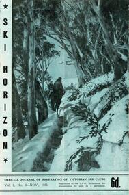
Journal - Ski-Horizon Vol. 3 No 3
Ski-Horizon is the official journal of the Federation of Victorian Ski Clubs which began publication in 1949. The were 26 original member clubs which included Albury Ski Club, Bogong Ski Club, Myrtleford Ski Club, Tallangatta and District Ski Club and Wangaratta Ski Club. Two pioneers of Falls Creek, Tom Mitchell, M.L.A., and Martin Romuld were Vice-Presidents of the Federation.This Journal is significant because it documents the early development of skiing in Victoria.The journal features stories and events chronicling developments in Victoria and internationally. Items related to the Falls Creek Area in this publication include:- Page 2: The road to Falls Creek from Howmans Gap likely to be closed while activities on the Kiewa Hydro Electric Scheme are restricted due to VIctoria's lack of finance for public works. Page 5 - A note from Fred Griffith (President, Albury Ski Club) gave plans for the club's annual Ski Ball on Friday, 30th November. It will be held in the Toonallook Woolshed. Fred says you are welcome to bring your sleeping bag and stay the night (what's left of it) at Toonallook where the recovery from hangover can be spent very pleasantly on the property or swimming and boating on the Hume Weir nearby. - N.E.D.S.A. officials are getting preparations in hand for the visit next year of a N.E.D.S.A. team to New Zealand. John Robertson, of Myrtleford Ski Club, is the Trip Secretary and Toni St. Elmo is acting at present as Manager.ski history victoria, federation of victorian ski clubs, ernest forras -
 Falls Creek Historical Society
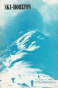
Journal - Ski-Horizon Vol 4 No 7
Ski-Horizon is the official journal of the Federation of Victorian Ski Clubs which began publication in 1949. The were 26 original member clubs which included Albury Ski Club, Bogong Ski Club, Myrtleford Ski Club, Tallangatta and District Ski Club and Wangaratta Ski Club. Two pioneers of Falls Creek, Tom Mitchell, M.L.A., and Martin Romuld were Vice-Presidents of the Federation.This Journal is significant because it documents the early development of skiing in Victoria.The journal features stories and events chronicling developments in Victoria and internationally. Items related to the Falls Creek Area in this issue include:- Page 2:- Tonl St. Elmo (Nissen Alpine Club) had been appointed as a Justice of the Peace. Climatologists with the CSIRO reported that the mean daily temperature of summer in Victoria and NSW had fallen by 3°F since 1880 whilst in the Northern Hemisphere summers were becoming warmer. Page 5: There was to be no Queen's Birthday holiday this year but Tuesday 2nd June would be a public holiday for Coronation Day. Page 11: Featured "They're Busy in the North-East" - nothing has been heard of the Sydney Clubs which had proposed building at Falls Creek and Beechworth seems to be in danger of losing its site. Nissen Alpine Club has had plans for extension approved. A new rope was being installed for the Nissen tow. Falls Creek was undoubtedly the most progressive centre in the North East. For a slightly rougher experience Cleve Cole Memorial Lodge was recommended.tom mitchell m.l.a., toonallook, fred griffith -
 Glen Eira Historical Society
Article - REGENT LODGE, REGENT STREET, 46, ELSTERNWICK
This file contains 10 items about the Regent Lodge Extension Appeal: 1/Three promotional pamphlets, all called ‘Regent Lodge: A special kind of care’, stating that a building appeal will be launched early next year. The pamphlets also list office bearers. 2/A letter from Rodney Horsfield, Chairperson of the Project Working group, to Betty Freeland of the Elsternwick-Caulfield South Parish, dated 25/03/1992, asking for her to consider becoming a member of the Appeal Team. The letter also contains information on the history of Regent Lodge, the plans for development and progress on raising funds to date. 3/A letter from Ian Clark, Chairman of the Regent Lodge Extension Appeal, to Betty Freeland, dated 18/05/1992, inviting her to the official launch of the Regent Lodge Extension Appeal at Caulfield Grammar School, 217 Glen Eira Road Caulfield on 31/05/1992. The letter gives brief details on the launch, saying it will be attended by the appeal’s patron, the Honourable Joan Child, AO, and the Playback Theatre company. 4/A letter, recipient and sender unknown, dated 26/05/1992, giving details of the appeal launch and a brief history of Regent Lodge. 5/Two newspaper articles from the Southern Cross, Caulfield, dated 16/06/1992. The first, ‘Grant boost for dementia sufferers’, discusses a federal government grant of $8 million to dementia services, and $9 million to disability services. Heathlands, Camden Court, Lovell House, Clarence Court, Regent Lodge and St. Kilda House all received funds. The second, ‘Lodge building appeal launched’, describes the Regent Lodge Extension Appeal and its launch, and includes brief comment by appeal patron Joan Child. The article describes the plans for the appeal and extension, and outlines how readers can make donations. Included is a black-and-white photograph of Joan Child with members of the Playback Theatre Group at the Appeal Launch. 6/The original of the photograph used in the newspaper article in item 5, showing Joan Child with members of the Playback Theatre Group at the launch of the Regent Lodge Extension Appeal. 7/A letter from Rod Horsfield, Convenor of the Project Working Group, to Betty Freeland, dated 22/06/1992, discussing the launch and asking for the opportunity to meet with her Parish council or Finance Committee. 8/The plans for the extension of Regent Lodge, as well as a colour drawing of what the front of the extension will look like. 9/Preliminary photographs taken for the appeal brochure ‘Regent Lodge: Committed to Caring’. Twelve black-and-white photographs of two elderly residents at tea. Also, one black-and-white photographs of an elderly resident being assisted by another person, likely a staff member. 10/Three copies of the appeal brochure ‘Regent Lodge: Committed to Caring’. The brochure contains information about the lodge, the plans for the development, including a floorplan for a typical six bedroom unit, the costs of the extension and breakdown of how the appeal target amount would be spent, and messages from patron Joan Child, Appeal Committee Chairman Ian Clark, and Convenor of the Project Working Group Reverend Rod Horsfield. Also included is a list of the members of the Appeal Committee and Project Working Group. Black-and-white photographs of residents and workers at the Lodge are included in the brochure.regent lodge, regent street, elsternwick, emma street, caulfield south, heathlands, camden court, lovell house, st. kilda house, balaclava, caulfield grammar school, glen eira road, st. georges road, caulfield, uniting church, uniting church lodge program, regent lodge alzeimer appeal, regent lodge extension appeal, tansley hunt and partners, nepean presbytery, child joan the honourable, horsefield rod rev., horsfield rod rev., horsfield rodney rev., lukies noela mrs., campbell jack, cardell bob, davies gail mrs., greensmith duncan, tansley vern, merrick ruth ms., seccull barbara ms., freeland betty miss, clark ian, wilcox rosemary mrs., coleman julie, playback theatre company, martens veronica mayor, brown george, terrell tom, diseases, disabled people, nursing homes, fundraising events, aged people -
 Federation University Historical Collection
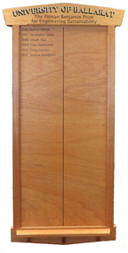
Honour Board, The Pitman Benjamin Prize for Engineering Sustainability Honour Board, c2006
The Pitman Benjamin Prize for Engineering Sustainability is awarded to the Civil Engineering student whose thesis best promotes sustainable engineering. It is awarded in memory of a Heather Pitman, the first woman to graduate in Engineering at Ballarat. The Pitman Benjamin Prize for Engineering Sustainability is sponsored by Benjamin Real Estate, and was first awarded in 2006. Heather was the first female graduate from Ballarat College of Advanced Education and obtained outstanding results. Throughout her career she worked predominantly in local government and for much of that time with the Shire of Ballarat, then the City of Ballarat. During that time she worked as a civil engineer and in planning. Heather was a trail blazer in many respects and was one of the first women to be employed into an engineering position at that time. It was not easy, and she applied for about 200 jobs before being employed by the Shire of Greensborough, north of Melbourne. In 2002 Heather Pitman was Land Development Engineer with the City of Ballarat. The following year she was the City of Ballarat's Manager, Building & Assets. Award sponsor Terry Benjamin was a great mentor of Heather’s sponsoring the award in her memory when she died suddenly at the age of 48. Honour Board, gold lettering University of Ballarat. Black lettering The Pitman Benjamin Prize for Engineering Sustainability. The Pitman Benjamin Prize for Engineering Sustainability has been awarded to: * 2006 - Nathan Whittle; * 2007 - Christopher Quinn; * 2008 - Vinoch Ravi; * 2009 - Troy Vanberkel; * 2010 - Nil; * 2011 - Craig Furniss; * 2012 - Joshua Handreck; * 2013 - Matthew Willis (not on board 10/6/2014); * 2013 - Daniel Camilleri (not on board 10/6/2014);pitman benjamin, nathan whittle, christopher quinn, vinodh ravi, troy vanberkel, craig furniss, joshua handreck, prize, engineering, sustainability, heather pitman, stuart benjamin, benjamin real estate -
 The Beechworth Burke Museum
Photograph, 1960s
This photograph was taken in the 1960s at Lake Sambell Caravan Park and visible in the photograph are individual caravan sites with electricity outlets, a large single-story building with a caravan park banner, dirt roads, a freestanding message board, and a parked car. Lake Sambell Caravan Park opened in 1959 owing to the work of R.E. Carter, Beechworth Shire engineer from 1954-63. Carter advocated for improvements to the lake and surrounding area in order to encourage tourism in Beechworth. The opening of the caravan park was part of many improvements to Lake Sambell made in this period by Carter including: the swimming pool in 1961, water skiing and boating facilities, and increased lake surface in 1964. These improvements were financed mainly by grants from the Tourist Development Authority. The popularity of caravanning in Australia exploded during this post-war period of the late 1950s and 1960s. This popularity was driven by multiple factors, including: the stopping of fuel rations, the accessibility of car ownership through the manufacturing of affordable cars, technological developments in caravan design, and the increase in prosperity and leisure time for many Australians. Facilities such as electrical outlets to power caravans are present in this photograph of Lake Sambell Caravan Park. Lake Sambell is an artificial lake that was developed on the previous site of the Rocky Mountain Mining Company workings and was officially opened by Minister for Lands, Mr Baily, on October 5, 1928. The disused and unattractive remains of the mine were converted into a recreational area intended for swimming, boating, and fishing. The lake is named after Mr L.H. Sambell, shire engineer and secretary of the Forward Beechworth Committee, who advocated for the enhancement of Beechworth into a tourist destination and was central to the planning and establishment of the lake. This photograph is of historical and social significance in providing insight into caravanning during the 1960s in Australia. Caravanning was extremely popular during the 1960s in Australia due to multiple social and economic factors including the stopping of fuel rations, the accessibility of car ownership through the manufacturing of affordable cars, technological developments in caravan design, and the increase in prosperity and leisure time for many Australians.Black and white rectangle photograph printed on photographic paper and unmounted.Reverse: 3536/ [logo back printing: KODAK/ VELOX/ PAPER] / C798 lake sambell caravan park, lake sambell, caravanning 1960s, caravan park, rocky mountain mining company, kodak velox paper, r.e. carter, l.h. sambell, caravan electricity outlets, tourist development authority, post-war prosperity, forward beechworth committee, lake sambell boating, lake sambell swimming pool, lake sambell fishing, artificial lake, travel 1960s, recreation 1960s -
 The Beechworth Burke Museum
Photograph, 1960s
This photograph was taken in the 1960s at Lake Sambell Caravan Park, visible in the photograph are individual caravan sites with electricity outlets, a large single-story building, a parked car, and two caravans partially obstructed by trees. Lake Sambell Caravan Park opened in 1959 owing to the work of R.E. Carter, Beechworth Shire engineer from 1954-63. Carter advocated for improvements to the lake and surrounding area in order to encourage tourism in Beechworth. The opening of the caravan park was part of many improvements to Lake Sambell made in this period by Carter including: the swimming pool in 1961, water skiing and boating facilities, and increased lake surface in 1964. These improvements were financed mainly by grants from the Tourist Development Authority. The popularity of caravanning in Australia exploded during this post-war period of the late 1950s and 1960s. This popularity was driven by multiple factors, including: the stopping of fuel rations, the accessibility of car ownership through the manufacturing of affordable cars, technological developments in caravan design, and the increase in prosperity and leisure time for many Australians. Facilities such as electrical outlets to power caravans are present in this photograph of Lake Sambell Caravan Park. Lake Sambell is an artificial lake that was developed on the previous site of the Rocky Mountain Mining Company workings and was officially opened by Minister for Lands, Mr Baily, on October 5, 1928. The disused and unattractive remains of the mine were converted into a recreational area intended for swimming, boating, and fishing. The lake is named after Mr L.H. Sambell, shire engineer and secretary of the Forward Beechworth Committee, who advocated for the enhancement of Beechworth into a tourist destination and was central to the planning and establishment of the lake. This photograph is of historic and social significance in documenting the enhancement of the Lake Sambell area overseen by R.E. Carter and providing insight into caravanning during the 1960s in Australia. Caravanning was extremely popular in Australia during the late 1950s and 60s due to multiple social and economic factors including the stopping of fuel rations, the accessibility of car ownership through the manufacturing of affordable cars, technological developments in caravan design, and the increase in prosperity and leisure time for many Australians. Black and white rectangle photograph printed on photographic paper and unmounted.Reverse: 3538/ [logo back printing KODAK/ VELOX/ PAPER] / C798lake sambell caravan park, lake sambell, lake sambell 1960s, lake sambell fishing, lake sambell boating, lake sambell swimming pool, r.e. carter, l.h. sambell, tourist development authority, caravanning 1960s, caravan electricity outlets, caravan park, forward beechworth committee, rocky mountain mining company, lake caravan park, caravan mid 20th century, beechworth tourism, travel in the 1960s, holiday 1960s