Showing 3069 items matching "scales"
-
 Eltham District Historical Society Inc
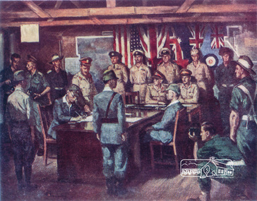
Photograph, Signing of World War II Peace Treaty
Print of painting of Signing of World War II Peace Treaty between Japan and USA includes various military personnel, Clem Scale top left.world war ii, japan, united states of america, military, clem scale -
 Ringwood and District Historical Society
Book - Account book, Warrandyte Lodge No.772, Warrandyte Lodge No.772 scale of Payments and Schedules, 30-Jun-1966 to 2-Jul-1975
Used in Ringwood by the Warrandyte Lodge No.772 for nine yearsBlue mottled cardboard covered book( Half of front cover missing) containing scale of payments and members schedule of deductions. 20 pages all used.Warrandyte Lodge No.772 Appearance Book -
 Federation University Historical Collection
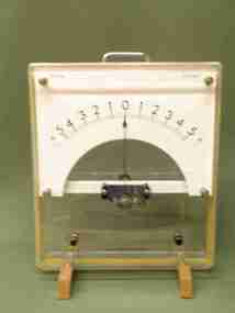
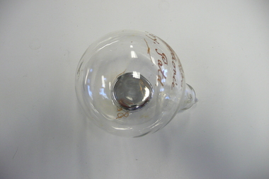
Scientific Object: Electrical Engineering, Moving coil D.C. Ammeter: Mod D.14-P
Upright rectangular ammeter in acrylic case with two timber 'feet'. Square chrome handle on the top. Semicircular scale, centre zero: 5A-0-5AMod: D.14-P; No 750 8Y Paton Electircal Sydneyscientific instruments, paton electrical, ammeter -
Federation University Historical Collection
Instrument - Scientific Instrument, Planimeter
A variable scale ration planimeter, calibrated in imperial units and in metric units. Housed in a black case with hinged lid. Complete with calibration table inside the case.planimeter, scientific instruments -
Port Melbourne Historical & Preservation Society
Map - MMBW, c. 1894
Melbourne and Metropolitan Board of Works Plan No. 323,330, 335, 336 Segments shown: As Plan No. Large scale plan of lagoon fill area (40'=1")engineering - board of works, sandridge lagoon, transport - tramways, engineering - canals and drainage, built environment, gasworks, business and traders - hotels -
 Coal Creek Community Park & Museum
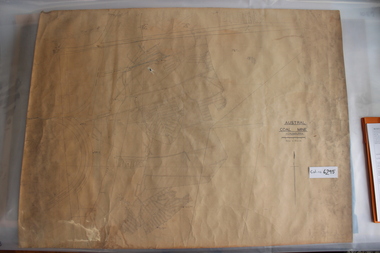
Mine Map
6295.1 - Large map of Korumburra coal mine; shows seams, tunnels, railways, roads and Leura Creek. There is a grid over the main area and a scale legend. -
 Bendigo Historical Society Inc.
Photograph - BILL ASHMAN COLLECTION: COHUNA BUTTER FACTORY SCALEBUOY
Black and white photograph showing scale taken from Cohuna Butter Factory boiler after Scalebuoy treatment, description hand written in ink on back.photograph -
 Bendigo Historical Society Inc.
Tool - SCALEBUOY
Mercury filled glass bulb, internal part of a Scalebuoy invented by Abbott Bros Bendigo, used to prevent build up of scale in water tanks, etc.A.C.Scalebuoy. Bendigo Electronic Coy Patd.sciences, instruments - general, scalebuoy -
 Bendigo Historical Society Inc.
Map - JACK FLYNN COLLECTION: KARA KARA, 1932
Map: County of Kara Kara, map sheet showing the whole of the County of Kara Kara and all of the Parishes within. Scale 2 miles to 1 inch.By Authority: W.M. Houston, Government Printer Melbourne. Department of Lands and Survey, Melbourne, 1958map, kara kara, county, kara kara -
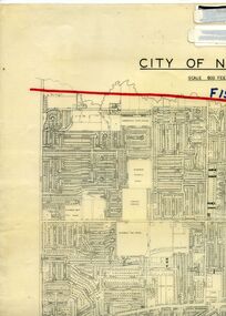 Whitehorse Historical Society Inc.
Legal record - Map, F19 freeway, 1/12/1977 12:00:00 AM
Approximate alignments of F19(Eastern) Freeway, F9 and Scoresby Freeway, marked on 1973 edition of City of Nunawading map,Approximate alignments of F19(Eastern) Freeway, F9 and Scoresby Freeway, marked on 1973 edition of City of Nunawading map, Scale 800 ft = 1 inch.Approximate alignments of F19(Eastern) Freeway, F9 and Scoresby Freeway, marked on 1973 edition of City of Nunawading map, freeways, city of nunawading, eastern freeway, scoresby freeway -
Bendigo Historical Society Inc.
Document - Eaglehawk Primary School Architect's Plan for Toilets, March 1980
Architect's plan for the Eaglehawk Primary school Toilets, David M. Breaden - Architects 145 High St Bendigo File 742 Scale 1:100history, national trust bendigo collection, bendigo, eaglehawk primary school, school -
 Bendigo Historical Society Inc.
Letter - Correspondence
Three page handwritten letter dated 28/06/1989. The letter is signed but unable to decipher the name. It is a letter replying to a question about scale buoy. scale buoys, bendigo electronic -
Beechworth Honey Archive
Map- Beechworth
Compiled from 1972 aerial photography. Printed in 1977.Map centred on Beechworth. SHows Beechworth toen, Wooragee, Reids Creek, Woolshed Falls and Lake Kerford. Scale 1:25,000 Printed colour on paper.Map labelled Reids Creek. No. 8225-3-1.map, beechworth, wooragee, reids creek, woolshed falls, lake kerford, aerial photography, paper, beechworth honey -
Maldon Vintage Machinery Museum Inc
Weighing Machine, 20th century
Used for many years outside the Pharmacy in the main street of Maldon.Avery upright weighing scale. Finished in white enamel with grey back plate. Weight is measured in pounds and stones. Platform is grey mosaic. Coin operated.Model No 3809 CFY Serial No S-621044instruments - weighing -
Maldon Vintage Machinery Museum Inc
Drawing Machine
Articulated arm type manual drawing machine with grey crachle finish. Very dark brown handle, chromed fittings. W&G scale rulers."Ray & Gilbert Pty Ltd / Serial No. 21XT"drafting, engineering -
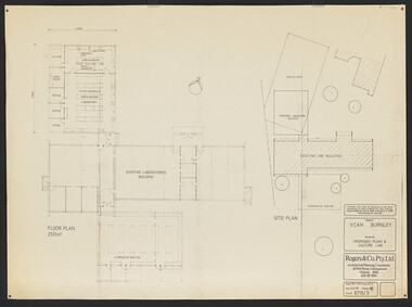 University of Melbourne, Burnley Campus Archives
Plan, VCAH Burnley Plant & Culture Lab, 1987
Floor Plan and Site Plan Dwg No 8716/3 by Rogers & Co. Pty. Ltd. Dated August 1987. Scale 1:100, 1:200.vcah, burnley -
University of Melbourne, Burnley Campus Archives
Plan, St James Park Feature Plan, 1983
City of Hawthorn Plan, drawing No P24/19, Sheet 1 of 1. Surveyed by L.B. & H.K. Traced by H.K. Aug 83. Scale 1:500.st james park, city of hawthorn, central gardens hawthorn -
Glenelg Shire Council Cultural Collection
Plan - Plans / Line Drawings - Port of Portland Authority Slipway Bilge Blocks, Wooden Vessel, Jane Kerr, victoria, 12/10/1982
PORT OF PORTLAND AUTHORITYFront: '8' - black texta, top right corner -
Glenelg Shire Council Cultural Collection
Plan - Plan / Line Drawing Port of Portland Slipway Bilge Blocks, Tug 'Kiama', 05/07/1987
Front: - black texta, top right cornerport of portland -
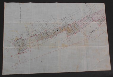 Bendigo Historical Society Inc.
Document - WES HARRY COLLETION: SURVEORS MAP ON LINEN OF HONEySUCKLE AND THISTLE STREETS
A surveyor's map to scale 4 chains to 1 inch of Honeysuckle & Thistle Streets, between Alley Street and Clark Street Unknown purpose of the plan - undated -
University of Melbourne, Burnley Campus Archives
Plan, Ratio Consultants Pty. Ltd, Conceptual Subdivision & Garden Layout Plan Project 'Rosecraddock' Rosecraddock Place Caulfield, 1991
Tracing paper plan by Ratio Consultants Pty. Ltd., for Mr P. Shellard, Project No 1887, drawing No LS3, October 1991. Scale 1:250.p. shellard, caulfield, ratio consultants, "rosecraddock", subdivision plans, landscape design -
Glenelg Shire Council Cultural Collection
Plan - Plans / Line Drawing 'FV Kosmo' general arrangement, Apr-87
Front: '29' - black texta, top right cornerport of portland -
Clunes Museum
Map, G.J. WILLIAMS, SHIRE OF TALBOT & CLUNES, UNKNOWN
BLACK AND WHITE HAND DRAWN MAP. SHIRE OF TALBOT & CLUNES. SHOWING SEALED ROADS, GRAVEL ROADS AND PARTLY FORMED ROADS. SCALE 1:100,000map, clunes, talbot -
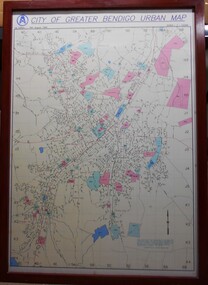 Bendigo Historical Society Inc.
Map - City of Greater Bendigo Urban Map 1996
A large framed colour map showing the urban area of Bendigo. The map dates to 19 August 1996. It is the first edition and has the scale 1:12500 -
Linton and District Historical Society Inc
Plan, Floor plan of Railway Hotel, Linton, undated
It is not known when the plan was drawn up or by whom.Laminated blueprint, showing 1/8 scale floor and block plan of the Railway Hotel in Sussex Street, Linton. Drawn in white ink on blue paper.railway hotel linton, maps and plans, floor plans -
 Bendigo Historical Society Inc.
Map - MINING PLAN ,VICTORIA HILL AREA, No date visible
Map: Large scale plan of an area of the Goldfield, Northward from Barnard Street, covering the Victoria Hill area. Black printing on polycarbonate film. Transparent.map, bendigo, mining plan, mining, gold mines, victoria hill, lines of reef -
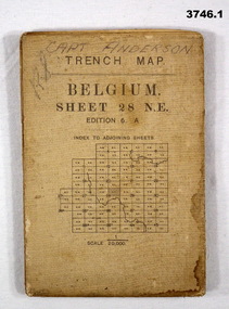 Bendigo Military Museum
Map - TRENCH MAPS, BELGIUM WW1, 1) 1917; .2) & .3) 1916
.1) Areas covered on this map include Zonnebeke, Broodseinde, Passchendaele, Westhoek, Glencorse Wood & Black Watch Corner. .2) Areas covered on this map include Bailleul, Neuve Eglise, Messines, Wyschaete, Warneton & Hollebeke. .3) Areas covered on this map include Poperinghe, Ypres, Dickebusch & Zillebeke. The maps are part of a collection of 27 collected by William Arthur ALEXANDER, No 502 AIF. He enlisted in the 8th reinforcements MG Coy 3 on 5.9.1916 aged 21 years. Embarked for England on 23.11.1916, transferred then to the 5th Div MG Coy. Embarked for France on 26.4.1917 then transferred to the 13th MG Coy on 16.6.1917. WIA 28.9.1917 gassed, he is later hospitalized with Colitis. Rejoined unit in the field 18.6.1918. Discharged from the AIF 18.9.1919..1) Trench Map, Belgium, sheet 28 NE Edition 6A, folding, scale 1.20,000, trenches corrected to 3.7.1917, German trenches in red. On rear glossary of terms French to English. .2) Trench Map, Belgium & France, sheet 28 SW Edition 3D, folding, scale 1.20,000, trenches corrected to 22.6.1916. German trenches in red, British in blue. On rear glossary of terms French to English. .3) Trench Map, Belgium, sheet 28 NW Edition 3D, folding, scale 1.20,000, trenches corrected to 25.6.1916. German trenches in red, British in blue. On rear glossary of terms French to English..1) Handwritten on front: “CAPT ANDERSON”maps, trench -
University of Melbourne, Burnley Campus Archives
Plan, Methodist Ladies College, 1986 -1988
(1) Site Plan showing Carparking by Hayball Sanderson & Partners Job No 86/142. Drawing No A1. Scale 1:55. November 1986. (2) Master Plan Courtyard Design by Richard Nosworthy, 8.11.88 Sheet No 2 (of 2) Elevation. (3) Master Plan MLC by Michael Doensen 8.11.88. Scale 1:100 Sheet No 1 of 2 Courtyard Planting Plan.Names: Cath Coates, Darren Wilson added in inkrichard nosworthy, michael doensen, methodists ladies college, kew -
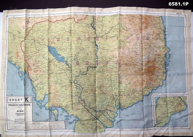 Bendigo Military Museum
Photograph - Photograph of a silk map of Indo China, Circa 1939
Silk maps were produced as "Escape Maps" as they were easily folded and compressed to carry. They were often sewn into the jackets of aircraft pilots..1P Photograph of a Silk map of Indo China Map No 44K covering Siam (Thailand) and part of Vietnam and Cambodia at a scale of 1:1million. The map has contours (heights) and legend panel information. .2P Photograph of the reverse side of a Silk map of Indo China Map No 44J covering Siam (Thailand) at a scale of 1:1million. The map has contours (heights) and legend panel information. royal australian survey corps, rasvy, fortuna, army survey regiment, army svy regt -
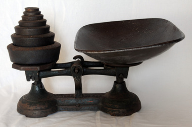 Orbost & District Historical Society
scales and weights, late 19th Century to 1920s
Jabez and John Whitehouse had the Phoenix Foundry in Castle Street, Tipton. These scales are interesting because they are a common domestic kitchen item used when all meals were prepared at home. A set of cast iron balance scales with seven weights up to 4 lbs. The pan is detachable and painted green. The pan seems to be made of tin. The weights are labelled.TO WEIGH 14 LBS weights - J. & J. Whitehouse TIPTONscales food-preparation weights cast-iron measurement