Showing 882 items matching "weatherboard houses"
-
 Kew Historical Society Inc
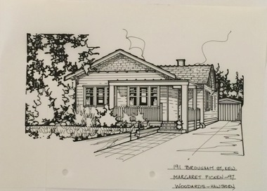
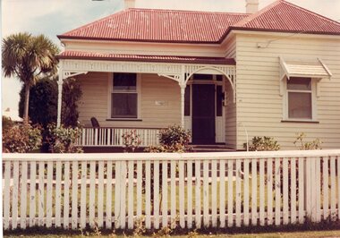
Drawing - Property Illustration, Margaret Picken, 191 Brougham Street, Kew, 1997
After training as a Cartographic Draftsman within the mining industry, I worked as a property illustrator for real estate firms in the eastern suburbs of Melbourne for 23 years from 1983. I initially photographed houses with a Polaroid camera and made a 'thumbnail' sketch while there. The photos were used to scale off a sketch in pencil and then that sketch was overlaid with drafting film and the 'pen and ink' completed. The pens I used were the Rotring ‘Rapidigraph’ drafting pens. The ink was also made by Rotring (German).The film was ‘Rapidraw’, polyester drafting film, double matte. It takes a very fine line and doesn’t bleed. As well as house sketches, there were often floor plans and site plans ordered. Aerial sketches were ordered when the property needed an overall view. (Margaret Picken, 2020)This drawing is one of a series created by Margaret Picken for a range of real estate agents in Melbourne between c.1983 and c.2005. Each work is signed and dated by the artist.Gift of Margaret Picken, 2020A 1920s weatherboard bungalow, now featuring a subsequent second floor addition. The pen and ink drawing on drafting film of 191 Brougham Street was made by Margaret Picken in 1997, and predates this addition.191 BROUGHAM ST., KEW / MARGARET PICKEN '97 / WOODARDS ~ HAWTHORNartist -- margaret picken 1950-, architectural drawings -- houses -- kew (vic.), 191 brougham street -- kew (vic.) -
 Kew Historical Society Inc
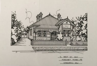
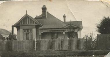
Drawing - Property Illustration, Margaret Picken, 16 Kent Street, Kew, 1993
After training as a Cartographic Draftsman within the mining industry, I worked as a property illustrator for real estate firms in the eastern suburbs of Melbourne for 23 years from 1983. I initially photographed houses with a Polaroid camera and made a 'thumbnail' sketch while there. The photos were used to scale off a sketch in pencil and then that sketch was overlaid with drafting film and the 'pen and ink' completed. The pens I used were the Rotring ‘Rapidigraph’ drafting pens. The ink was also made by Rotring (German).The film was ‘Rapidraw’, polyester drafting film, double matte. It takes a very fine line and doesn’t bleed. As well as house sketches, there were often floor plans and site plans ordered. Aerial sketches were ordered when the property needed an overall view. (Margaret Picken, 2020)This drawing is one of a series created by Margaret Picken for a number of real estate agents in Melbourne between 1983 and 2005. Each work is signed and dated by the artist.Gift of Margaret Picken, 2020Double-fronted weatherboard Edwardian residence; named 'Goodwood'. Pen and ink architectural drawing on drafting film of 16 Kent Street, Kew by Margaret Picken. 16 KENT ST., KEW / MARGARET PICKEN '93 / WOODARDS ~ KEWartist -- margaret picken 1950-, architectural drawings -- houses -- kew (vic.), 16 kent street -- kew (vic.) -
 Kew Historical Society Inc
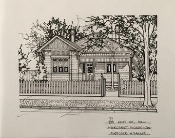
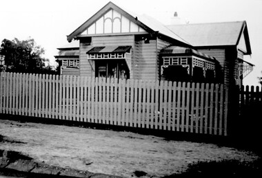
Drawing - Property Illustration, Margaret Picken, 31 Kent Street, Kew, 2000
After training as a Cartographic Draftsman within the mining industry, I worked as a property illustrator for real estate firms in the eastern suburbs of Melbourne for 23 years from 1983. I initially photographed houses with a Polaroid camera and made a 'thumbnail' sketch while there. The photos were used to scale off a sketch in pencil and then that sketch was overlaid with drafting film and the 'pen and ink' completed. The pens I used were the Rotring ‘Rapidigraph’ drafting pens. The ink was also made by Rotring (German).The film was ‘Rapidraw’, polyester drafting film, double matte. It takes a very fine line and doesn’t bleed. As well as house sketches, there were often floor plans and site plans ordered. Aerial sketches were ordered when the property needed an overall view. (Margaret Picken, 2020)This drawing is one of a series created by Margaret Picken for a number of real estate agents in Melbourne between 1983 and 2005. Each work is signed and dated by the artist.Gift of Margaret Picken, 2020Double-fronted Edwardian weatherboard villa. Pen and ink architectural drawing on drafting film of 31 Kent Street by Margaret Picken in 2000. Subsequent alterations and additions made in 2006. 31 KENT ST., KEW / MARGARET PICKEN 2000 / FLETCHER & PARKERartist -- margaret picken 1950-, architectural drawings -- houses -- kew (vic.), 31 kent street -- kew (vic.) -
 Kew Historical Society Inc
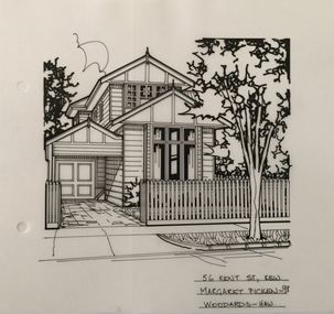
Drawing - Property Illustration, Margaret Picken, 56 Kent Street, Kew, 1998
After training as a Cartographic Draftsman within the mining industry, I worked as a property illustrator for real estate firms in the eastern suburbs of Melbourne for 23 years from 1983. I initially photographed houses with a Polaroid camera and made a 'thumbnail' sketch while there. The photos were used to scale off a sketch in pencil and then that sketch was overlaid with drafting film and the 'pen and ink' completed. The pens I used were the Rotring ‘Rapidigraph’ drafting pens. The ink was also made by Rotring (German).The film was ‘Rapidraw’, polyester drafting film, double matte. It takes a very fine line and doesn’t bleed. As well as house sketches, there were often floor plans and site plans ordered. Aerial sketches were ordered when the property needed an overall view. (Margaret Picken, 2020)This drawing is one of a series created by Margaret Picken for a number of real estate agents in Melbourne between 1983 and 2005. Each work is signed and dated by the artist.Gift of Margaret Picken, 2020Originally a single-storey Edwardian weatherboard villa with a later two storey addition. Pen and ink architectural drawing on drafting film of 56 Kent Street, Kew by Margaret Picken in 1998.56 KENT ST., KEW / MARGARET PICKEN '98 / WOODARDS ~ HAW.artist -- margaret picken 1950-, architectural drawings -- houses -- kew (vic.), 56 kent street -- kew (vic.) -
 Sunbury Family History and Heritage Society Inc.
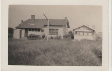
Photograph, c1920s - 1930s
In the 1920s a few Californian style homes were built in the township of Sunbury and some of them can still be seen in the town.A black and white photograph of the rear view of a weatherboard Californian style bungalow built in an open paddock. The house also has a smaller building on the RHS and an outdoor toilet as well as a double clothes line are in the yard. sunbury township. -
 Sunbury Family History and Heritage Society Inc.
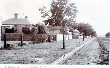
Photograph - Evans Street, Sunbury, c1900s
The photograph shows a picture of Evans Street Sunbury taken from the T intersection at Macedon Street and looking south. When the photograph was taken it was one of Sunbury's main residential areas. Since the 1980s the houses in the image have been demolished and replaced with commercial development. Over the years Evans Street has undergone much change from being a residential strip to being the main commercial hub in Sunbury.A sepia photograph with a white border across the bottom and in post card format of a streetscape with a row of trees growing along the footpath and a number of weatherboard Victorian style double fronted cottages. Both the roadway and footpath are not surfaced and the gutter is lined with stone pavers.EVANS STREETevans street -
 Stawell Historical Society Inc
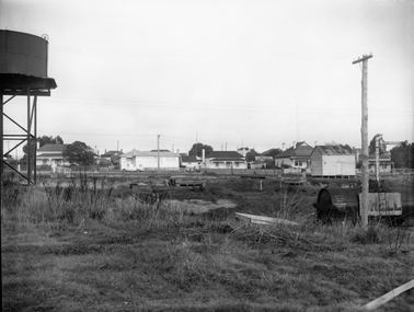
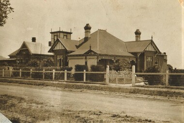
Photograph, Railway Yards looking towards Wakeham Street c1960, approx 1965
Railway Yards Stawell looking towards Wakeham Street with water tank on left. c1960B/W Photgraph of Rail yards looking towards Wakeham Street. View shows water tank which was used in Steam engine days. house on left, Cnr. Sloane & Wakeham Streets No. 50 was adapted into two flats ( Possibly in the 190's. The weatherboard building on the right was the headquarters for the Stawell Homing Club ( Pigeon Club) Circa 1960's The Word Shell is visible on a train carriage.stawell railways transport -
 Stawell Historical Society Inc
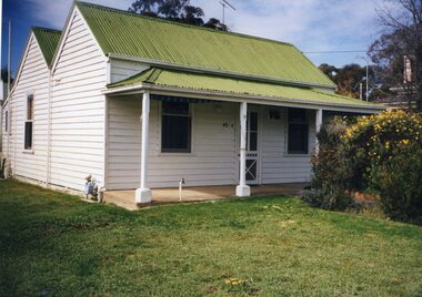
Photograph, 36 Ligar Street -- Weatherboard Cottage of Mr W Rees & Family 1998 -- Coloured
... W Rees) taken in 1998 Stawell Houses 36 Ligar Street ...Colour photograph of cottage 36 Ligar Street (Rees family W Rees) taken in 1998stawell houses -
 Stawell Historical Society Inc
Photograph, 19 Campbell Street Stawell -- weatherboard house c1985-1986
... 19 Campbell Street Stawell -- weatherboard house c1985-1986... 19 Campbell Street Stawell -- weatherboard house c1985-1986 ...House 19 Campbell Street Stawell 1985-1986stawell houses -
 Surrey Hills Historical Society Collection
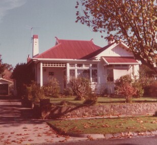
Photograph, 5 York Street, Mont Albert, May 1985 (1), 1985
This is the home of Ernest Augustus Young (1891-1985) and Ruby Nichell Whitby (1892-1984) and their son Ernest Lance Young. Lance was born 24 March 1915 in Surrey Hills; after he married Beryl Mair. Electoral roll for 1937 gives the house name as 'Whitby Lodge'. Ernest and Ruby also had twins Clive and James who died in infancy. Buried at Box Hill Cemetery - M-*-0867 (family plot) This is part of a large collection relating to the Mair, Deakin and Young families. REF: Memoir of Laurie Newton (nee Young) - Her grandfather bought the land and had the house built. She remembers it as having pressed ceilings in some rooms and ornate fireplaces and tiles and leadlight windows in some rooms and doors with leadlight panels. Her grandfather was a keen gardener with an ornamental front garden and many vegetables and fruit trees in the back yard. Her grandfather sold the adjoining block (No 3 York Street), which had been used for growing flowers and vegetables, to John and Edna Jean. Reid. She also remembered that he extended the house and divided it into 2 flats, renting out the northern side for 20 years. Sold by Jellis Craig on 24 December 2010 - With formal living, dining, 3 bedrooms, 2 bathrooms, garage/ample OSP. Land: 18.2m x 40.8m (60' x 134') approx. Large 2 storey house replaced the house.Colour photo of the street view of 5 York Street, Mont Albert. The house is Edwardian in style, constructed from weatherboard painted white with a red corrugated iron roof with simple finials. There is a small veranda with simple fretwork, lead-light feature windows to one, possibly two front rooms, one of which has a bay window. There is a garage set back at the side of the house with a concrete driveway on the south side of the house towards Mont Albert Road. The fence is low and constructed from roughly faced stone. The garden contains mature shrubs.In blue biro on rear: "1985 / POP'S" ; "5 YORK ST / E.A. YOUNG". Red photographic processing stamp "PROCESSED BY / KODAK / MAY 85M"ernest augustus young, ruby nichell whitby, ruby nichell young, ernest lance young, box hill cemetery, whitby lodge, house names, mont albert -
 Surrey Hills Historical Society Collection
Photograph, Sister Ann Elizabeth Dowsley's home in Elgar Road, Box Hill, c1939
... bungalow home set behind a picket fence and hedge. The house... home set behind a picket fence and hedge. The house appears ...This was the home of Sister Ann Elizabeth Dowsley, daughter of Thomas Dowsley and Mary McKay. She was born in St Arnaud in 1887. She enlisted on 22 August 1916. As a AANS Matron in WW1 she served in India. She was awarded a Royal Red Cross award for conspicuous services. She did not marry. She died in December 1960 at Caulfield. There is a photo of her in Punch, Thursday 31 August, 1916, p 21. REF: Laurie Newton - Ernest Lance Young and Beryl (nee Mair) bought the house from Sister Dowsley for £895 on their marriage in 1939 but sold it when Lance was sent to Darwin during his war service. Beryl purchased 11 York Street in later war years. This property was also significant for Ernest Lance Young and Beryl Mair. It may have been the childhood home of their children Barbara and Ken, but Laurie was probably born after they moved to York Street. Lance was born 24 March 1915 in Surrey Hills, the son of Ernest Augustus Young and Ruby Nichell Whitby. He married Beryl Mair in 1939 and died on 5 October 1999 at Mont Albert. Electoral rolls list him as a manufacturer. He is buried in Box Hill Cemetery (M-*-0867) along with his father. He served in WW2 (Service Number - VX104733 enlisting at St Kilda) and after returning took over his father's business. The Mair family were resident in Barton Street for several generations. Beryl's father Dave Mair was a keen sportsman and founder of the Kangaroo Social Club of cricketers. This is part of a large collection relating to the Mair, Deakin and Young families. Black & white photo of the street view of a Californian bungalow home set behind a picket fence and hedge. The house appears to be weatherboard and render with a terracotta tile roof and a simple chimney.In blue biro on rear: "Our first home", "Sister Dowsleys home at / Elgar Rd B Hill"; "YOUNG" In lead pencil on rear: " 3 (pound symbol) 895" Photographic processing stamps "14" and (?) "GRANVILLE PRINT" within a triangle. ann elizabeth dowsley, world war 1, nurse, elgar road, ernest lance young, beryl young, beryl mair -
 Surrey Hills Historical Society Collection
Photograph, 10 Pembroke Street, Surrey Hills
‘Eignbrook’ at 10 Pembroke Street was built 1904. Until the 1950s this area was the highest spot in the metropolitan area and ships in the Bay could be seen from ground level and views extended almost 360 degrees. A number of homes of this Edwardian period had viewing towers, the one in the photo being that of ‘Maroondah’ at 12 Pembroke Street. Photo taken by W V Hill. Courtesy: Mr William (Bill) Dempsey. Original sepia photograph of a weatherboard home in the Queen Anne style. It has a steep pitched iron roof. It has a woven wire fence across the front of the property and decorative gates. Mounted on white cardboard photo taped on 2 corners.Back of photo is inscribed “Hills, 10 Pembroke St, Surrey Hills”. Card has written underneath the photo, “10 Pembroke St, Home of Hills family, built 1904”pembroke street, house names, surrey hills, hills family, 'maroondah', 'eignbrook', (mr) w v hill, (mr) william (bill) dempsey, journalist, queen anne style, (mrs) annie hill -
 Surrey Hills Historical Society Collection
Photograph, 10 Pembroke Street, Surrey Hills
William Valentine Hill (1854-1940) journalist, was the owner of 'Eignbrook',10 Pembroke Street from 1904. His wife was Annie Boak (1865-1943); they were married in 1885. William Hill (Bill) Dempsey was his grandson. His mother Laura Constance Hill married Herbert T Dempsey in 1925.Original sepia photograph of the street view of a weatherboard in the Queen Anne style with a steep pitched iron roof; house is fronted by a picket fence. There are 2 copies of this original photo; the better copy has been scanned. The second copy is slightly mottled and the edges left and right have been cropped so that the adjacent house is not seen. Back of photo 1 is inscribed “10 Pembroke St. Donor W Dempsey”. Photo 2 has inscribed on back "Hills home, 10 Pembroke St, Surrey Hills. Donor W Dempsey" Card has written underneath the photo, “10 Pembroke St”pembroke street, hills family, 'eignbrook', house names, surrey hills, (mr) william valentine hill, journalist, (mrs) annie hill, (miss) annie boak, queen anne style -
 Surrey Hills Historical Society Collection
Photograph - Digital photograph, 9 Beatrice Avenue
... A black and white photograph of an Edwardian style house... to this collection. The house has been demolished and there are units ...Built in late 1912 for Mr Edmund Holt and his wife Ruby Ellen (nee Sutton). Edmund came from Coburg where his family had a grocery business. The Holt family lived there from 1913-1945. There were 3 children: Alan Judge (1912-1993); Frederick Sutton (1914-1992) and Raymond James (1918-2000). When Edmund Holt died, Mrs Holt remained there until 1952. Alan Judge Holt was Secretary of the Victorian Lands Department and a keen and meticulous local historian who contributed significantly to this collection. The house has been demolished and there are units on the site. The photo is significant as a record of past built heritage and for its association with the Holt family who were long-time residents of the area.A black and white photograph of an Edwardian style house. It is weatherboard and has a picket fence across the front.beatrice avenue, surrey hills, edwardian style, weatherboard, edmund holt, miss ruby sutton, mrs ruby holt, alan judge holt, frederick sutton holt, raymond james holt -
 Surrey Hills Historical Society Collection
Photograph, Yielima, 31 Erasmus Street, Surrey Hills
Known as ‘Yielima’ 1888-1922 and ‘St. Aubins’ 1922-1956, this ‘modernized’ mansion was built about 1887 for Edward Kellett. He was born in Chorley, Lancashire, England. Edward Kellett married Selina Wells in 1852 at St Peters, Eastern Hill. She was born in c1827 in Aston Clinton, Buckinghamshire, daughter of William Wells and Elizabeth Allan. The family arrived from Aylesbury, Buckinghamshire on the 'Osprey' on 22 March 1849. The couple had 8 children - 5 girls and 3 boys; 3 died in infancy. All were born in Collingwood before the family came to Surrey Hills. Edward's funeral notice in The Argus of 11 July 1893 states that he was a corn merchant of Exhibition Street. His property was sworn at 1512 pounds, 1232 in realty and 280 pounds personally. He was buried in Melbourne General Cemetery (CofE Compartment K, No 306). Selina is listed in Erasmus Street in the 1903, 1905 and 1908 electoral rolls as a boarding house keeper. She died at Surrey Hills on 22/10/1911. In her will she left realty valued at 900 pounds and personally at 220 pounds. She was buried with her husband. 'Yielima' was sold on 19 Febraury 1919 with a sale of contents on 18 March 1919. From 1922-1947 Thomas Daniel O’Callaghan (c1871-1962), a police magistrate, made his home here. He is remembered as being of ‘soldierly demeanour, with a flowing mane of hair’. He always carried a walking stick and wore a flower in his buttonhole. His wife was Florence (nee Harling, c1873-1933) pre-deceased him. They had previously lived in Essendon, Moonee Ponds and Stawell before coming to Erasmus Street. After moving out of Erasmus Street he is listed in the 1949 and 1954 electoral rolls at 90 Durham Road, Surrey Hills. In 1952 the property was purchased by Father Timothy Fitzpatrick, Parish Priest of Our Holy Redeemer Parish, Surrey Hills. It consisted of a large two storey house, a coach house and stable, and an acre and a half of land. In 1954 the coach house and stable were converted into the Church of Our Lady of Perpetual Succour and the following year Father John Kelly was appointed parish priest. and resided in the house. At this time the house was not in good repair. "The gentleman who had lived there alone since his wife died many years before, lived in the servants quarters and the rest of the house had been badly neglected. (REF: https://ourholyredeemer.cam.org.au/history) At the beginning of 1957 the Missionary Sisters of the Sacred Heart opened a school next door. As they travelled from Balwyn on a daily basis, the property at 301 Elgar Road was purchased as a presbytery and 'Yielima' became a convent. The stables continued to be used as a church until 1964 when a new church was completed and opened by His Grace Archbishop Simmonds on the 20th of March. There were never large numbers of double-storey Victorian mansions in Surrey Hills. 'Yielma' is significant as one of the few remaining ones. It is also significant for its association with the Catholic Church.A black and white photograph of an Italianate style home with a weatherboard building with a cross on it in front of the main building and to the left of the photograph. There are some well established trees in the garden, a car parked in the parking area and a picket fence along the front.yielima, st aubins, house names, erasmus street, surrey hills, 1887, (mr) edward kellett, (mr) thomas daniel o'callaghan, corn merchant, police, italianate style, wattle park roman catholic church, (mrs) florence o'callaghan, mrs selina kellett, miss selina wells, convent, presbytery, our lady of perpetual succour -
 Surrey Hills Historical Society Collection
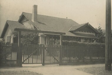
Photograph, "Braemar" 18 Suffolk Road, Surrey Hills
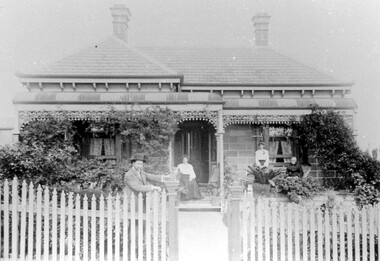
"Braemar" at 18 Suffolk Road, Surrey Hills - built c1894, demolished in1977 – and home of James Sneddon Snr. and family from 1890 until c1950. We believe it is James is at the gate and his family on the veranda. James was born in Alloa, Clackmannanshire Scotland in 1833, as was his wife Jane. He died in March 1901 and she in March 1911. They are buried in Boroondara Cemetery (Pres B0522) with their daughter Jane (1864-1928). James Sneddon (Snr) was an important man in early Surrey Hills. He established real estate and ironmongery businesses in Union Road – first on the corner of Stirling Crescent and later over the road on the corner of Windsor Crescent. He was chairman of Surrey Hills’ MUIOOF (Manchester Unity Independent Order of Oddfellows). James Sneddon Jnr. followed his father in the family real estate business and was an even busier community man. He was a JP and had roles in the Surrey Hills ANA, the Progress Association and the Choral Society. He lived 2 doors from his father. The real estate business continued on the corner of Windsor Crescent and Union Road (north side) until the business was sold to the Doubleday (family) after WW2.The Sneddon family were early settlers and business owners in Surrey Hills and remained over 3 generations. Different family members held many roles in community organisations. This photo is also important in documenting built heritage that has been demolished.Image of a Victorian, weatherboard, block fronted, single storey house with decorative veranda, viewed from the front. The garden in front of the house is well established and a light-coloured picket fence surrounds the property. Four people are in the photograph, three women (two seated and one standing) on the veranda and one male, who is leaning against the gate post.buildings, structures and establishments, houses, timber houses, house names, braemar, architectural styles, victorian style, families, family group, sneddon family, james sneddon (snr), boroondara cemetery, real estate agent, ironmonger -
 Surrey Hills Historical Society Collection
Photograph, Harbert family home, 237 Union Road, Surrey Hills
Albert George Harbert was a local builder. His family home was built c1910. He married Phoebe Rebecca Georgina Colton in 1912. They had 2 daughters Norma Phoebe and Unice Ada (18 Jan 1918 - 6 Jan 2014). Norma was married to and divorced from Henry Jamieson. Albert died 31/8/1968; Phoebe died 15/6/1971; they are buried in Boroondara Cemetery. Photo probably taken in late 1980s-early 1990s.A black and white photograph of a Queen Anne style house. It has a steeply pitched iron roof, is weatherboard with a veranda and fretwork around it. A picket fence runs along the front.queen anne style, union road, surrey hills, builder, 1910, federation style, albert harbert, mrs norma phoebe jamieson, miss norma phoebe harbert, miss unice harbert, mrs phoebe rebecca georgina harbert, miss phoebe rebecca georgina colton, union road -
 Surrey Hills Historical Society Collection
Photograph, Charles Henry Maling and family at 'The Willows', Shepreth Street, Surrey Hills (demolished), 1930s
“The Willows” home of John Butler Maling on south side of Whitehorse Road in Shepreth Street, near Banool Road. He built 2-roomed mud brick cottage in about 1861 extending it in stages into a weatherboard Victorian villa as his family grew. John Butler Maling's uncle (also John Butler Maling lived nearby at 'Ancyra' at 26 Weybridge Street). 'The Willows' was situated on a small farm of c13 acres with a creek running through it, lined with willows. The house was demolished after J B Maling's death in 1931 when the land was subdivided, some of it having been previously bought by the Education Department for the site of Chatham Primary School. J B Maling trained his six sons as builders. Charles Henry and his family are pictured in this photo. Charles Henry Maling (1875-1953) married Katherine Mitchell (1875-1958) in 1901. They lived at 9 Benson Street, Surrey Hills but came to live at 'The Willows' for 5 years prior to 1931 to care for Charles' father. Charles and Katherine are the older man and woman centre back with daughter Ellen Grace, known as Nell (1882-1960) in the front of them. Right front seated on the pillar is daughter Jane Emma (1872-1980) with her baby. Her husband Robert Wilhelm (Bob) Sutherland is the younger man at the back. The occasion is thought to be the christening of their first child. The other people are Rev O Cordell, his wife Mary and their children who are friends visiting from Africa where the donor, Rev Charles Maling, son of Charles Henry Maling was working with the Church Mission Society. A black and white photograph of a group of people standing (one lady sitting) on the front steps of a house.the willows, house names, (mr) john butler maling, whitehorse road, banool road, balwyn, surrey hills, (mr) charles henry maling, (mrs) katherine maling, (miss) nell maling, (mrs) jane sutherland, (mr) bob sutherland, (rev) o cordell, (mrs) mary cordell -
 Surrey Hills Historical Society Collection
Photograph, 27 Suffolk Road, Surrey Hills
... A colour photo of a Victorian style house constructed from... Road Canterbury melbourne Since this photo was taken, the house ...Since this photo was taken, the house has had a second storey added.A colour photo of a Victorian style house constructed from weatherboard painted in a light cream / pink colour with block detail to the front. It has a grey corrugated iron roof with 2 chimneys, a bull-nosed veranda painted in white and Indian red stripes and the veranda has wrought iron 'lace' panels and fretwork in white. There is a white Ford Falcon in the driveway.suffolk road, houses, victorian style -
 Port Fairy Historical Society Museum and Archives
Photograph
... early residences tarrangower gipps street house building ...Tarrangower Pt Fairy 1905Black & white photograph of Early weatherboard home with verandah at front Tarangower Port Fairy 29.04.1905early residences, tarrangower, gipps street, house, building, weatherboard -
 University of Melbourne, Burnley Campus Archives
Photograph - Black and white print, Principal's Residence, 1913
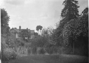
Note from T.H. Kneen 13 February 1991, "Right hand tall tree is Californian Redwood. Over Pergola-Banksia Rose." On 19 November 1991, "Weatherboard construction of right rear of residence was modified/replaced to provide a bedroom for Mr. McLennan's family - he had 6 daughters. That room was later converted to a bathroom with three large storage cupboards." 2 copies black and white photograph. B91.17 and B91.18. View of various trees, shrubs and flowers. House on rise. On reverse "1913."trees, shrubs, flowers, californian redwood, mr. mclennan, principal's residence, principal's house, cordyline -
 Surrey Hills Historical Society Collection
Photograph, Church of Christ, The Avenue, 1990
Built c 1889. The current Church of Christ is on the left. One of the foundation families was that of Mr and Mrs John Woodhead, who owned the land from Union Road to Warrigal Road and from Canterbury to Bona Vista Avenue in 1885. Mr Woodhead built 'Kirkland' in Union Road - in 1889/90. The land for the church was given by Mr Woodhead. Photograph taken in 1990.A coloured photograph of a weatherboard building with two windows at the front with brown painted surrounds, and a brown painted wooden door. There is a path leading to the door and looks to be a building on each side. There is a large tree in the background.Church of Christ/ Surrey Avenuekirkland, house names, union road, surrey hills, warrigal road, canterbury road, bona vista avenue, (mr) john woodhead, church of christ, churches -
 Surrey Hills Historical Society Collection
Photograph - Digital photograph, George L Coop, 688 Whitehorse Road, Mont Albert 1958, 1958
... of the front veranda of 688 Whitehorse Road. The house is white... of the front veranda of 688 Whitehorse Road. The house is white ...The donor George Lister Coop was about 21 years of age when he took this photo in 1958 of his family home. His parents were George Burton Coop (b c1906 Williamstown; died aged 54 years at Mont Albert) and Winsome Alice (MS: Trewartha) who married in 1936. They are first listed at this address in the electoral roll in 1937. They had 2 children: George Lister Coop - born St Georges Hospital, 8/10/1937 and Alison - born c1945. However the donor informed that he initially attended Chatham State School because his first home was the Spanish Mission style flats at 346 Whitehorse Road, opposite Brenbeal Street, Balwyn. When his grandparents died, the family moved to 688 Whitehorse Road and he then attended Mont Albert Central School. Alison being younger did not go to Chatham Primary. A digital copy of a colour photo showing detail of the front veranda of 688 Whitehorse Road. The house is white weatherboard in a modified Californian bungalow style with a tiled roof and the carport built within the roofline. The balustrades and finials of the veranda are simple with occasional feature planks with a tulip detail. A bird cage hangs from the veranda. The veranda is supported by rough-cast sturdy pillars.george l coop, whitehorse road, mont albert, uniting church, californian bungalow -
 Surrey Hills Historical Society Collection
Photograph - Digital photograph, George L Coop, 688 Whitehorse Road, Mont Albert 1958, 1958
... of the front view of 688 Whitehorse Road. The house is white... of the front view of 688 Whitehorse Road. The house is white ...The gentleman in the photo is George Burton Coop, an architect / draughtsman. The donor, his son George Lister Coop was about 21 years of age when he took this photo in 1958 of his family home. His parents were: George Burton Coop (b c1906 Williamstown; died aged 54 years at Mont Albert) and Winsome Alice (MS: Trewartha) who married in 1936. They are first listed at this address in the electoral roll in 1937. They had 2 children: George Lister Coop - born St Georges Hospital, 8/10/1937 and Alison - born c1945. However the donor informed that he initially attended Chatham State School because his first home was the Spanish Mission style flats at 346 Whitehorse Road, opposite Brenbeal Street, Balwyn. When his grandparents died, the family moved to 688 Whitehorse Road and he then attended Mont Albert Central School. Alison being younger did not go to Chatham Primary. A digital copy of a colour photo showing detail of the front view of 688 Whitehorse Road. The house is white weatherboard in a Californian bungalow style with a tiled roof and shingles detail in a dark brown stain. The balustrades and finials of the veranda are simple with occasional feature planks with a tulip detail. A bird cage hangs from the veranda. The veranda is supported by rough-cast sturdy pillars. The house sits behind a cypress hedge. The photo was taken in winter as deciduous shrubs are bare. A gentleman astride a ladder is pruning the hedge. george l coop, whitehorse road, mont albert, californian bungalow, cypress hedge, gardening, george burton coop -
 Canterbury History Group
Photograph - Weatherboard House in Golding Street Canterbury, c1950
... Weatherboard House in Golding Street Canterbury... Weatherboard House in Golding Street Canterbury ...Edwardian timber house at 6 Golding Street, corner of Short Street Canterbury. Lady on the verandah was Miss Jacobs, housekeeper for owner Mr. Edwin Comport. black and white photograph.canterbury, golding street, short street, edwardian style, kerbing and guttering, comport> edwin, jacobs> miss -
 Melton City Libraries
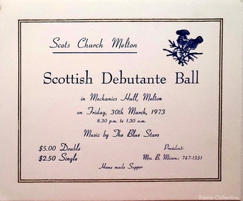
Card, Scottish Debutante Ball invite, 1973
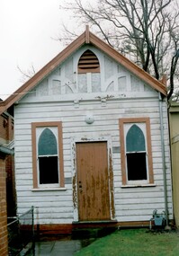
"The Mechanics’ Institute hall (demolished) and the library played a central role in the story of Melton social life, and in the development of its learning, culture, entertainment, celebration, commemoration and many community groups. The building on the site today - with the Court House the only remaining early community or public building remaining in High Street - is a tribute to the energy and talents of the very small Melton community over many years. Its substantial size, brick materials, and the evident use of an architect in its design, sets it apart from most other simple weatherboard Mechanics’ Institutes that were built in smaller country towns in Victoria. The financing and upkeep of this building, which was community-owned until 1982, and built on land purchased by the community rather than granted by Government, itself contributed to the coming together of the Melton community in decision making and fundraising. Although the original hall is demolished, the 1983 Melton Community Hall adjacent is partly its successor, demolition of the Institute hall having been predicated on its construction. The surviving brick front portion of the Institute was opened by the Hon. J Murray, Premier of Victoria in 1910". Scottish Debutante Ball hosted by Scots Church Melton at the Mechanics Hallchurches -
 Melton City Libraries
Newspaper, Get the good oil here…, 2001
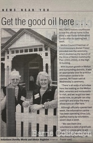
"A court was established in Melton by 1864, when the first recorded case was heard before Mr BA Porter JP, with Mr A Carroll as the Clerk of Courts. John James was convicted of being drunk, for which he was fined five shillings or 24 hours imprisonment. The court was held in the ‘long room’ of the old Melton Hotel, before moving to rented accommodation at the Raglan Hotel, and finally to the Roads Board office. Tenders for construction of the present building were called for by the Public Works Department on 13th February 1892. The architect Samuel Edward Brindley was born in Birmingham, England, in 1842. He was articled to the local architect, J.R. Botham, FRIBA, before emigrating to Victoria where he was employed as an architect in the Education Department from 18 August 1873. With the amalgamation of the architectural branch of the Education Department with the Public Works Department in 1884, Bindley was placed in charge of Victorian government building design for the North-Western District. In 1975, the Melton and District Historical Society became concerned at hearsay that the court house was to be demolished to make way for carparking space. Melton had been declared a ‘satellite city’ and was developing rapidly. A new shopping centre had recently been built at a setback of 60 feet (c.18 metre) from 323-329 High Street, and the court house, together with the adjacent weatherboard police station, had been left standing alone. A new police station was planned, and the weatherboard police station was subsequently demolished. In its nomination of the building for National Trust classification the Society argued that the Court House was ‘the best of two early buildings left in the main street’ (the other being a bluestone hotel) and that its loss would be ‘tragic’. However the nomination was unsuccessful, the National Trust at the time judging that it was of no particular ‘distinction’ or ‘antiquity’. The building continued to be used as a court house at least until 1991 when the Department of Housing and Construction (formerly the PWD) conducted a heritage study of court houses. By this time Federation-era architecture had achieved acceptance within the heritage movement. The building was recognised as being ‘the only surviving example in brick of the Federation Queen Anne style which was used for court houses only twice.’ Twenty years later when it was proposed to modify the eastern façade of the building to accommodate a café, the M&DHS was again concerned. This time the National Trust objected that the proposed extension would be an over-development of the site, and questioned the changes to the interior court room furnishings and fittings. The site never appears to have been nominated to the Victorian Heritage Register. It has since been converted into the Shire of Melton Tourist Information Centre". Opening of the Visitor Centre in Meltoncouncil, local architecture -
 Truganina Explosives Reserve Preservation Society Inc (TERPS)
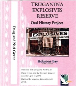
Digitised Oral History – Truganina Explosives Reserve - Tape 1 Doug and Noel Grant, 2018
The interviews were recorded in 2000 by Bronwen Gray and Alan Young for the production of Unreserved, Stories from Truganina Explosives Reserve, animated stories from past residents, workers and interested people of the Reserve (subject to copyright 2004). Doug and Noel Grant’s Grandfather, Don Grant, was officer in charge of Truganina Explosives Reserve from 1910-1930. On his retirement, his son, William (known as Bill) took over the position until 1956. Along with their two older brothers and younger sister, Doug and Noel Grant grew up, first in the assistant manager’s weatherboard cottage and then in the brick house which was set aside for the officer in charge, until they married and moved into their own homes in their early 1920s. On returning from the second world war, Noel Grant worked as a magazine assistant of explosives on the site from 1946, When the site had closed down in 1962 he worked as an inspector of explosives at the Explosives Branch in Melbourne until he retired in 1985. During that time Noel was asked to move back on site, meaning that three generations of Grants have lived on the site during the twentieth century. Doug Grant worked for ICI/Nobel in head office in 1940 and their older brother Alan worked at the Nobel Explosive Company in Deer Park from 1937. After returning from the Second World War, Alan bought a transport business that had once had the licence to cart explosives in and around the state. They discuss their memories of the living at Truganina Explosives Reserve and the workings of the Reserve, including the names of men who worked there, ships which carried the explosives and life in and around Altona. A primary source of information on memories of the Truganina Explosives Reserve and Altona,VictoriaDigital copy of original cassette recorded in 2000 and digitised in 2018hobsons bay, altona, galvanised iron fence, picket fence, golf course, altona school, margaret grant, bill grant, explosives magazine, lighters, joe hyde, alex grant, pines scout camp, maribynong river, 1896, inspector of explosives, pier, point wilson, werribee sewerage farm, george grant, lighterman, huia, argonaut, pirie, alma doepel, merton street altona, horse, jessie grant, jean grant, sandal, kilmartin, lewis, currie, todd, robinson, balwyn -
 Tarnagulla History Archive
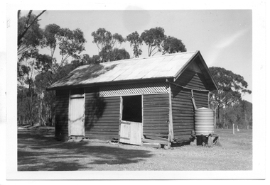
Photograph of former Tarnagulla Police Stable, Former Tarnagulla Police Stable, Mid 20th Century
Murray Comrie Collection. The town block where this stable was located was the base for policing in Tarnagulla from 1878 until the 1990s. The block was bounded by Stanley, Victoria, Wood and Gladstone Streets. The stable was built in 1886. An image of the stable in 1924 is THA-2019.0031. Monochrome photograph of a stable which once housed police horses in Tarnagulla. Dark red or brown weatherboard with white doors. tarnagulla, police, policing, horses, buildings -
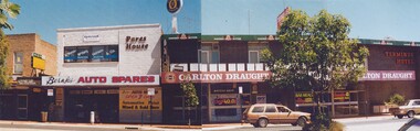 Wodonga & District Historical Society Inc
Photograph - Terminus Hotel and Pares House
The Terminus Hotel, Wodonga was built by James Thompson Hatch in 1873, the same year the railway reached Wodonga from Melbourne. It was named due to its close proximity to the railway terminus. It was sold to Messrs George Day and Kenneth McLennan of Albury. It was first licenced to J.G. Morton in January 1874. Annie Allen, from Ireland, took over as licensee of the hotel containing 14 rooms in 1879, after she and her husband, George James Allen, purchased it. In 1887 they added a new wing on the south boundary of the property next to Peter McLean’s store at 81 Sydney Road. The architects for the new wing were Gordon and Gordon. A billiard room, a dining room, and 18 other rooms were added on the vacant block of land between the Hotel and the Bank of Victoria. A balcony 6 feet wide was added on the north side. Included in the plans was the latest patent elevator, later known as a dumb waiter. Allen died in 1889 aged 52, and Annie Allen continued to run the Terminus. She later married John G. Haldon and was licensee of the hotel until December 1898 when the licence was transferred to William Carkeek. Carkeek, from Cornwall, arrived in the colony around 1860 and is considered one of the founders of Tallangatta. In November 1903, the license was transferred to Daniel Crawford, then in 1906 it was transferred to Mr Stephen Carkeek. In 1916 it passed into the hands of Mr H. W. Allen of Rutherglen, son of Mr George James Allen. On 1st June 1998 the Terminus Hotel was destroyed by fire. Estimates of damage range from between a conservative $750,000 to as high as $2 million. The remains of the building were demolished in 1999.The Terminus Hotel was one of the earliest hotels in Wodonga with clear links to the establishment of the railway line. It was an important business and meeting place for social gatherings.In 1879, the Terminus Hotel was purchased by Annie and George Allen. The hotel was advertised as a two storey brick building with bar, large dining and four rooms on the ground floor, all and commodious cellar. Upstairs a large parlour and 13 bedrooms. There was also a four-roomed weatherboard cottage, a blacksmith's shop and other buildings. The Allens had about 20 years of ownership, with Annie continuing to hold the licence under her new married name of Annie Haldon after George had died in 1889. In 1888, the Allens undertook extensive additions and renovations. Annie remained as the proprietor of the building until her death in 1904, but the business was leased to William Carkeek in December 1898. The building was eventually auctioned as part of the finalising of Annie's estate in 1909.hotels wodonga, businesses wodonga, terminus hotel wodonga