Showing 33889 items
matching building-fittings
-
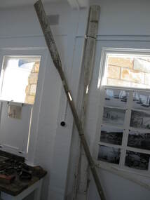 Parks Victoria - Wilsons Promontory LightstationThe two wooden oars were formerly painted white. They were used on lightstation boats and are now displayed on the wall of Room 2 which is located next to the light tower. Numerous images of the lightstation show rowing boats either on stand‐by on land or in the sea performing duties in the surrounding sea and at the East Landing. The wooden boat rudder with brass and other metal fittings was also formerly painted white and is possibly from the same boat that used the oars. Meets second level threshold.Two long wooden oars, Residue of white paint. Possibly made of Australian hardwood. They were used on lightstation boats.
 -
 Parks Victoria - Mount Buffalo Chalet
Crockery
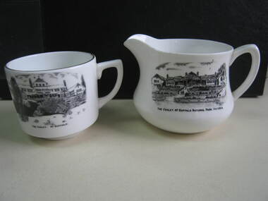
The jug and cup were purchased from a second - hand shop in Bairnsdale. Jug is older than cup as the chalet is represented as a single storey structure. The cup is later as the second storey appears in the illustration. 'Souvenirs in relation to the Chalet and Mount Buffalo wee first mention in December 1912... A large range of souvenirs has since been associated with the Chalet and Mount Buffalo from crafted wooden items, silver spoons, cups etc... The collection includes a broad selection of products that have been sold throughout much of the Chalet's history, each representative of the transient fashions of their period.' (Pg. 114. Historica) 'A group of tableware items is notable for its black transfer printed decoration, which features the Chalet building. Interestingly, the printed designs represent the Chalet at two different stages in its building history under the Victorian Railways, in 1926 after completion of the north wing, and 1937-39, after the second storey is added to the front.. manufactured in England by A.B. Jones and sons, a Stoke on Trent pottery firm which operated under the trade name of Grafton China between 1900-1972.' (Pg. 114. Historica)Listed in Draft Inventory of Significant Collection Items . Appendix A.3. Souvenirs. (Pg 168. Historica)..1] Ceramic jug. Souvenir of Mt Buffalo. White ceramic squat milk jug with a black transfer illustration/drawing on front side. Picture is of the MtBuffalo Chalet from the front. Some worn gold glaze detail. It appears to be a single story building with a planted garden at the front with a fence. Trees to one side and people walking up steps. "THE CHALET, MT BUFFALO NATIONAL PARK, VICTORIA." is written under the illustration. Jug has a faint crack. .2] White ceramic cup with gold edging around top of cup. Black transfer drawing of the chalet with a second storey. Rocks and tree in foreground and "THE CHALET. MT BUFFALO." underneath transfer. .1] "THE CHALET, MT BUFFALO NATIONAL PARK, VICTORIA." is written under the illustration. On the base of the jug, with sun motif, "ENGLAND / GRAFTON CHINA /A / B J / & SONS / LOFTUS MORA / PTY. LTD" .2] "THE CHALET. MT BUFFALO." underneath transfer. Under cup, "A.B.J. / GRAFTON / CHINA / MADE IN / ENGLAND" -
 Kew Historical Society Inc
Plan, Melbourne & Metropolitan Board of Works / Borough of Kew, Detail Plan No.1593, 1905
The Melbourne and Metropolitan Board of Works (MMBW) plans were produced from the 1890s to the 1950s. They were crucial to the design and development of Melbourne's sewerage and drainage system. The plans, at a scale of 40 feet to 1 inch (1:480), provide a detailed historical record of Melbourne streetscapes and environmental features. Each plan covers one or two street blocks (roughly six streets), showing details of buildings, including garden layouts and ownership boundaries, and features such as laneways, drains, bridges, parks, municipal boundaries and other prominent landmarks as they existed at the time each plan was produced. (Source: State Library of Victoria)This plan forms part of a large group of MMBW plans and maps that was donated to the Society by the Mr Poulter, City Engineer of the City of Kew in 1989. Within this collection, thirty-five hand-coloured plans, backed with linen, are of statewide significance as they include annotations that provide details of construction materials used in buildings in the first decade of the 20th century as well as additional information about land ownership and usage. The copies in the Public Record Office Victoria and the State Library of Victoria are monochrome versions which do not denote building materials so that the maps in this collection are invaluable and unique tools for researchers and heritage consultants. A number of the plans are not held in the collection of the State Library of Victoria so they have the additional attribute of rarity.Original survey plan, issued by the MMBW to a contractor with responsibility for constructing sewers in the area identified on the plan within the Borough of Kew. The plan was at some stage hand-coloured, possibly by the contractor, but more likely by officers working in the Engineering Department of the Borough and later Town, then City of Kew. The hand-coloured sections of buildings on the plan were used to denote masonry or brick constructions (pink), weatherboard constructions (yellow), and public buildings (grey). The laborious task of hand-tinting these Board of Works plans was not without hazards as is evidenced by Plan No. 1593. On the Plan, the original colourist spilt black and green ink, partially obscuring some parts. The most obvious casualty is ‘Clifton’ located on the corner of Cotham Road and Park Street [now Adeney Avenue]. Included in this Plan, and outlined in pink is that part of the section that the contracting engineer was tasked with completing. This included sewering on both sides of this part of Cotham Road, but excluded properties such as ‘Glendonald’ and ‘Monnington’. This area was to undergo a series of subdivisions including the ‘Clifton Estate’, which created housing lots on Adeney Avenue and Florence Avenue in 1916. The most notable occupant of Clifton was William Adeney [died 1893], a pioneer of Camperdown, after which Park Street was later renamed.melbourne and metropolitan board of works, detail plans, survey plans - borough of kew, mmbw 1593, cartography -
 Kew Historical Society Inc
Plan, Melbourne & Metropolitan Board of Works : Borough of Kew : Detail Plan No.1291, 1905
The Melbourne and Metropolitan Board of Works (MMBW) plans were produced from the 1890s to the 1950s. They were crucial to the design and development of Melbourne's sewerage and drainage system. The plans, at a scale of 40 feet to 1 inch (1:480), provide a detailed historical record of Melbourne streetscapes and environmental features. Each plan covers one or two street blocks (roughly six streets), showing details of buildings, including garden layouts and ownership boundaries, and features such as laneways, drains, bridges, parks, municipal boundaries and other prominent landmarks as they existed at the time each plan was produced. (Source: State Library of Victoria). This plan forms part of a large group of MMBW plans and maps that was donated to the Society by the Mr Poulter, City Engineer of the City of Kew in 1989. Within this collection, thirty-five hand-coloured plans, backed with linen, are of statewide significance as they include annotations that provide details of construction materials used in buildings in the first decade of the 20th century as well as additional information about land ownership and usage. The copies in the Public Record Office Victoria and the State Library of Victoria are monochrome versions which do not denote building materials so that the maps in this collection are invaluable and unique tools for researchers and heritage consultants. A number of the plans are not held in the collection of the State Library of Victoria so they have the additional attribute of rarity.Original survey plan, issued by the MMBW to a contractor with responsibility for constructing sewers in the area identified on the plan within the Borough of Kew. The plan was at some stage hand-coloured, possibly by the contractor, but more likely by officers working in the Engineering Department of the Borough and later Town, then City of Kew. The hand-coloured sections of buildings on the plan were used to denote masonry or brick constructions (pink), weatherboard constructions (yellow), and public buildings (grey). A detail plan of part of Studley Park bordered by the major streets of Hodgson Street, Stevenson Street and Studley Park Road. Included on the plan are a number of significant Studley Park mansions in existence at the beginning of the 20th century. The unnamed street shown in the middle of the plan is McEvoy Street. The most important house still extant is Campion House, formerly named Dalsraith [Dalswraith] and Glendalough, owned since the 1940s by the Society of Jesus. Campion House can be seen on the corner of Hodgson and Studley Park Road. Its stables at the rear of the block have now been incorporated into a contemporary residence. An interesting feature of the plan is the 1910 annotation by Ed Seitz, professional designing engineer. Is Seitz the contractor who modified the MMBW original?melbourne and metropolitan board of works, detail plans, mmbw 1291, cartography -
 Kew Historical Society Inc
Plan, Melbourne & Metropolitan Board of Works : Borough of Kew : Detail Plan No.1564, 1905
The Melbourne and Metropolitan Board of Works (MMBW) plans were produced from the 1890s to the 1950s. They were crucial to the design and development of Melbourne's sewerage and drainage system. The plans, at a scale of 40 feet to 1 inch (1:480), provide a detailed historical record of Melbourne streetscapes and environmental features. Each plan covers one or two street blocks (roughly six streets), showing details of buildings, including garden layouts and ownership boundaries, and features such as laneways, drains, bridges, parks, municipal boundaries and other prominent landmarks as they existed at the time each plan was produced. (Source: State Library of Victoria)This plan forms part of a large group of MMBW plans and maps that was donated to the Society by the Mr Poulter, City Engineer of the City of Kew in 1989. Within this collection, thirty-five hand-coloured plans, backed with linen, are of statewide significance as they include annotations that provide details of construction materials used in buildings in the first decade of the 20th century as well as additional information about land ownership and usage. The copies in the Public Record Office Victoria and the State Library of Victoria are monochrome versions which do not denote building materials so that the maps in this collection are invaluable and unique tools for researchers and heritage consultants. A number of the plans are not held in the collection of the State Library of Victoria so they have the additional attribute of rarity.Original survey plan, issued by the MMBW to a contractor with responsibility for constructing sewers in the area identified on the plan within the Borough of Kew. The plan was at some stage hand-coloured, possibly by the contractor, but more likely by officers working in the Engineering Department of the Borough and later Town, then City of Kew. The hand-coloured sections of buildings on the plan were used to denote masonry or brick constructions (pink), weatherboard constructions (yellow), and public buildings (grey). In 1905, when Plan No.1564 was printed, that part of Kew bordered by Brougham Place (now Daniell Place), Mount Street, Sackville Street and Ross Street was already the location of a number of large mansions. Here, subdivisions, at least at this stage, produced larger blocks than in Central Kew. Many of the houses on this plan are named: ‘Faybrook’, ‘Northumbria’, ‘Parkholm[e]’, ‘Dunboe’, ‘Katoomba’ and ‘Eschol’ fronting Sackville Street. Eschol was once the home of the manufacturer Robert Harrison, whose cordial factory in Spring and Argyle Streets Fitzroy are noted on the Victorian Heritage Register. ‘The Hawthorns’ on the corner of Brougham Place and Mount Street was the home of the medical practitioner Frank William Fay, who won the military cross and other honours for conspicuous gallantry and devotion to duty in World War 1.melbourne and metropolitan board of works, detail plans, mmbw 1564, cartography -
 Kew Historical Society Inc
Plan, Melbourne & Metropolitan Board of Works : Borough of Kew : Detail Plan No.1570, 1905
The Melbourne and Metropolitan Board of Works (MMBW) plans were produced from the 1890s to the 1950s. They were crucial to the design and development of Melbourne's sewerage and drainage system. The plans, at a scale of 40 feet to 1 inch (1:480), provide a detailed historical record of Melbourne streetscapes and environmental features. Each plan covers one or two street blocks (roughly six streets), showing details of buildings, including garden layouts and ownership boundaries, and features such as laneways, drains, bridges, parks, municipal boundaries and other prominent landmarks as they existed at the time each plan was produced. (Source: State Library of Victoria)This plan forms part of a large group of MMBW plans and maps that was donated to the Society by the Mr Poulter, City Engineer of the City of Kew in 1989. Within this collection, thirty-five hand-coloured plans, backed with linen, are of statewide significance as they include annotations that provide details of construction materials used in buildings in the first decade of the 20th century as well as additional information about land ownership and usage. The copies in the Public Record Office Victoria and the State Library of Victoria are monochrome versions which do not denote building materials so that the maps in this collection are invaluable and unique tools for researchers and heritage consultants. A number of the plans are not held in the collection of the State Library of Victoria so they have the additional attribute of rarity.Original survey plan, issued by the MMBW to a contractor with responsibility for constructing sewers in the area identified on the plan within the Borough of Kew. The plan was at some stage hand-coloured, possibly by the contractor, but more likely by officers working in the Engineering Department of the Borough and later Town, then City of Kew. The hand-coloured sections of buildings on the plan were used to denote masonry or brick constructions (pink), weatherboard constructions (yellow), and public buildings (grey). Plan No.1570 shows the layout of gardens and houses in Sackville Street, Davis Street, Wrixon Street, and Fitzwilliam Street in 1904. While Thomas Street is included on the map, at this stage no houses had been built. The plan identifies two named houses: ‘Fairview’ and ‘Kylemore’. Fairview is more fully delineated in Plan No.1563. Kylemore is one of the few houses in Kew designed by John Beswicke. The most notable owner of Kylemore was William Whitehead, who owned the house between 1895 and 1900. In 1894, Australian newspapers reported the marriage of Whitehead’s daughter to Dr. Gerald Eugene Cussen, the brother of Sir Leo Cussen, the Supreme Court Judge. The married couple was to live at ‘Wilton’ (now the Kew RSL) from 1911-15.melbourne and metropolitan board of works, detail plans, mmbw 1570, cartography -
 Kew Historical Society Inc
Plan, Melbourne & Metropolitan Board of Works : Borough of Kew : Detail Plan No.1572, 1905
The Melbourne and Metropolitan Board of Works (MMBW) plans were produced from the 1890s to the 1950s. They were crucial to the design and development of Melbourne's sewerage and drainage system. The plans, at a scale of 40 feet to 1 inch (1:480), provide a detailed historical record of Melbourne streetscapes and environmental features. Each plan covers one or two street blocks (roughly six streets), showing details of buildings, including garden layouts and ownership boundaries, and features such as laneways, drains, bridges, parks, municipal boundaries and other prominent landmarks as they existed at the time each plan was produced. (Source: State Library of Victoria)This plan forms part of a large group of MMBW plans and maps that was donated to the Society by the Mr Poulter, City Engineer of the City of Kew in 1989. Within this collection, thirty-five hand-coloured plans, backed with linen, are of statewide significance as they include annotations that provide details of construction materials used in buildings in the first decade of the 20th century as well as additional information about land ownership and usage. The copies in the Public Record Office Victoria and the State Library of Victoria are monochrome versions which do not denote building materials so that the maps in this collection are invaluable and unique tools for researchers and heritage consultants. A number of the plans are not held in the collection of the State Library of Victoria so they have the additional attribute of rarity.Original survey plan, issued by the MMBW to a contractor with responsibility for constructing sewers in the area identified on the plan within the Borough of Kew. The plan was at some stage hand-coloured, possibly by the contractor, but more likely by officers working in the Engineering Department of the Borough and later Town, then City of Kew. The hand-coloured sections of buildings on the plan were used to denote masonry or brick constructions (pink), weatherboard constructions (yellow), and public buildings (grey). Plan No. 1572 represents the built environment bordered by Barkers Road, Wrixon Street, Edgevale Road and Fitzwilliam Street. Other streets identified on the plan include Stansell Street. Plan 1572 shows that by 1903-05, there was only patchy development in this area of Kew, mainly on Edgevale Road and Fitzwilliam Street. Only two named houses are identified: the quaintly named ‘Tweed Cottage’, and ‘Mendip’. The earliest reference to Treed Cottage in Australian newspapers is to the death of Walter Thompson, aged 74 who was a resident there in 1885. His youngest daughter was to die there in 1908. Mendip to the north of Tweed Cottage was owned by Henry Thompson; he was to die in 1901; his wife in 1932. At this period of time, Malin Street and Clivedon Court did not extend to Barkers Road.melbourne and metropolitan board of works, detail plans, mmbw 1572, cartography -
 Warrnambool and District Historical Society Inc.
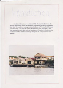
Work on paper - Project, Proudfoot's Boat House, Late 20th century
Proudfoots’ Boathouse was built in 1885 by Thomas Proudfoot and has remained an important historic building in Warrnambool to this day. In the late 20th century the original buildings were lifted and renovated and a new building constructed in front. This material on Proudfoot’s boathouse will be of considerable use for researchers on the buildings, especially the detail on the 1990s renovations and additions.This is a Warrnambool Secondary College school assignment (Claire Isaac) about Proudfoot’s Boathouse in Warrnambool. There are twelve unnumbered typed papers on white paper (A4 size) and five loose newspaper cuttings. The typed pages are outlined in red. Included are black and white photographs (copies) and colour photographs.proudfoot’s boathouse, claire isaac -
 Greensborough Historical Society
Photograph - Digital image, Dennis Ward, Greensborough Primary School Gr2062 Painting Portrait, 25/06/2015
The old brick building at Greensborough Primary School on Grimshaw Street. Built in 1879, this building is now heritage listed by the National Trust. This photograph shows a painting of the school, hanging in the old building. Details unknown.Digital copy of colour photographgreensborough primary school, greensborough state school -
 Lake Bolac & District Historical Society
Photograph - Black and white photograph, Saddlery-Sweet Shop Lake Bolac c.1880, c1880
Thomas Leach and Beatson Pitkethley married in 1880 and had a saddlery and sweet shop in this wooden building. This building was also the first Bush Nursing Centre in 1928. This photo was taken of the building in 1999. It was later demolished.black and white photographthomas leach, beatson pitkethley, saddlery, sweet shop, bush nursery centre -
 Greensborough Historical Society
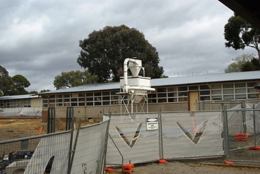
Photograph - Digital Image, Marilyn Smith, Greensborough College. Construction 2017, 01/10/2017
These photographs show the construction of new buildings and refurbishment of existing buildings and grounds at Greensborough College, 2017.Digital copy of colour photograph.greensborough college -
 Greensborough Historical Society
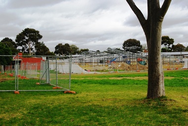
Photograph - Digital Image, Marilyn Smith, Greensborough Secondary College Gr8750 Construction 2017, 01/10/2017
These photographs show the construction of new buildings and refurbishment of existing buildings and grounds at Greensborough College, 2017.Digital copy of colour photograph.greensborough college -
 City of Ballarat Libraries
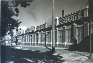
Photograph - Card Box Photographs, Sunshine Biscuits Factory, Ballarat circa 1955. From Bartrop's Consultants File
The factory was located on Victoria Street. The western corner of the building was saved when the rest of the building was demolished.sunshine biscuits, building, manufacturing, commerical, victoria street, ballarat -
 Surrey Hills Historical Society Collection
Compact disc, Melbourne Directory 1884 (Sands & McDougall)
The Sands and McDougall directories are amongst the most comprehensive. You can find out more details about places in which people lived, the other residents in the area, the services available in the region...all of which help to paint a picture of your ancestors' life. Apart from the Street, Alphabetical, Trade and Professional directories, this volume also contains Government and Official, Ecclesiastical, Legal, Municipal, Colonial, Societies and Institutions directories. A fascinating feature in this volume is a Universal Building Societies Supplement which includes 15 pages of architectural house plans of the day - layouts and elevations - with the house price for each.The Sands and McDougall directories are amongst the most comprehensive. You can find out more details about places in which people lived, the other residents in the area, the services available in the region...all of which help to paint a picture of your ancestors' life. Apart from the Street,Alphabetical, Trade and Professional directories, this volume also contains Government and Official, Ecclesiastical, Legal, Municipal, Colonial, Societies and Institutions directories. A fascinating feature in this volume is a Universal Building Societies Supplement which includes 15 pages of architectural house plans of the day- layouts and elevations- with the house price for each.streets, trade, agriculture, government, legal, ecclesiastical, farmers, farm workers, clergy, plans, timber houses, brick dwellings, buildings, structures and establishments -
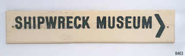 Flagstaff Hill Maritime Museum and Village
Sign - Shipwreck Museum sign, Flagstaff Hill Historic Park Planning Board, Shipwreck Museum, ca. 1975
This sign is painted on both sides. It was attached to the bluestone wall on the western wing of the Lighthouse Keeper's Quarters, the Assistant Keeper's Quarters, at Flagstaff Hill Maritime Museum and Village for almost 50 years. The Complex was opened to the public on December 11, 1975, and officially opened by Victorian Premier Sir Rupert Hamer on July 8th, 1977. The sign's reverse side reads "Loch Ard Peacock & Museum". The three rooms had displays behind glass showing various ships' fittings, cargo and personal belongings recovered from significant shipwrecks along the southwest coast of Victoria. There was also a display of information about the mysterious Mahogany Ship or Ancient Wreck. The shipwreck artefacts were recovered by local divers in the 1960s and early 1970s. Also on display was the famous Loch Ard Peacock, created in 1873, survived the shipwreck in 1878, was purchased by Flagstaff Hill in 1975 and announced as being on display in The Standard of September 15, 1975. In about 1984 the other side of the sign was painted "SHIPWRECK MUSEUM" and re-displayed on the building. The Loch Ard Peacock was by that time on display in the Entrance building; plans were underway on August 31st 1984 to build a Hall for its unique display. In February 2023 the sign was removed from the building, which was undergoing restoration and preparation for use as a new Temporary Exhibition space. The Loch Ard Peacock continued its journey around the Village; it was moved from the Entrance to the Village's newly completed Public Hal in 1986. It also spent a short time in the Stella Maris Tea Rooms. This was likely around 1998, when the Common School had moved from the Chartroom building to what had been the Public Hall. The Loch Ard Peacock was once again moved in around 2001, this time to be the central attraction and meeting place in the Great Circle Gallery, which opened on December 31st 2002. The sign continued to be displayed on the western wing of the Lighthouse Keeper's Quarters until February 2023. This wing has now been restored and re-fitted to become a facility for short-term exhibitions. A section of the original internal wall frame and wallpaper that couldn’t be kept in the building due to preservation issues have been saved and become sort of the Flagstaff Hill Collection. The sign has guided the visitors of Flagstaff Hill Maritime Museum and Village to the exhibits of artefacts from historic and significant shipwrecks. It has connected the current generations to the people and objects of the past, leading to a better understanding of our Colonial history.Sign, wooden, rectangular, with a hole through each short side. The front and reverse have different painted text. Cream paint for the background colour, green paint for the lettering, and the reverse has a white painted border. The front has an arrow painted on the right-hand side. The sign was used at Flagstaff Hill since its opening.Text on front "SHIPWRECK MUSEUM >" Text on back "LOCH ARD PEACOCK / & MUSEUM"flagstaff hill maritime museum and village, warrnambool, great ocean road, shipwreck coast, sign, building sign, shipwreck museum, loch ard peacock & museum, flagstaff hill history, assistant lighthouse keeper's cottage, assistand lighthouse keeper's quarters, public hall, common school -
 Eltham District Historical Society Inc
Photograph, N. J. Tillings Timber Factory, 15 June, 1975, 15/06/1975
N. J. Tillings Timber Factory was part of the Brougham Street, Light industrial area, Eltham. Brick bulidings includes signage: Wakefield Pr... (printer?) No 17 Building C. This is one of 7 B/W 8x10 inch photos with notes on obverse by Dick Crichton. Accompanying letter from Florence Chrichton 2013 : "Originally sent to Shire of Eltham Engineer, Mr. McDonald. [These photographs were part of their campaign to the Shire of Eltham in 1975] claiming that the zoning regulations were being breached by the occupants of various factories in the nearby light industrial zone [Brougham Street, Eltham] - to the detriment of those living in adjoining residential zones, and that, despite .. earlier objections and complaints, nothing was done about it."1 black and white photograph printed with white borderInscribed on back: "Weekend photograph of factories in Brougham Street surrounded by by residential zone. On weekdays cars surround premises - these have been built approx. two years - where is the landscaping? * Undeveloped light industrial land. Careful planning needed for future. Being on high elevations backs of future buildings will be seen from Main Road Eltham and future Art Centre complex. Also Bolton Street becoming heavily used arterial road. Off street parking facilities most important." . The front of the photo has pen marks indicating points of interest.industrial estate, brougham street, eltham -
 Royal District Nursing Service (now known as Bolton Clarke)
Photograph - Photograph, black and white, 15 05 1967
The Royal District Nursing Service (RDNS) Sister is leaving Headquarters, 452 St. Kilda Road, Melbourne, to administer nursing care to patients in their own homes. The Sisters nursed patients referred by Hospitals and General Practitioners giving treatments, such as injections, wound care and doing other procedures, as well as assisting them with general care when required. The Sister is driving an Australian built Holden car of the 1960s which, along with the other parked Holden cars are part of the RDNS fleet of vehicles. From its inception in 1885 the Trained nurses (Nurses) of the then named Melbourne District Nursing Society (MDNS), later named Royal District Nursing Service (RDNS) gave high quality nursing care to patients in their own homes. They nursed patients referred by Hospitals and General Practitioners giving treatments, such as injections, wound care and doing other procedures, as well as assisting them with general care when required. From the early days the Nurses taught the importance of good hygiene, cleanliness, good nutrition in the prevention and curing of disease and in maintaining good health, as well as giving advice and support to the patient and their carers. The Sisters liaised with the patient’s Doctor. District has had various modes of transport over the last 130 years. At first the Nurses walked the streets and lane ways amid the slums of central Melbourne. As the Society expanded bicycles, public transport, District cars, the use of a Motor Auxiliary, nurses own cars, and even a motorcycle were used, and all these forms were intermingled until RDNS had its own fleet of vehicles. By 2009 there were 598 cars in the fleet and the nurses travelled 9 million 200,000 kilometres – this is equivalent to 12 trips to the moon and back. The Royal District Nursing Service (RDNS) building at 452 St. Kilda Road, Melbourne was originally called 'Airlie', the childhood home of Stanley Melbourne Bruce, the Prime Minister of Australia 1923-1929. RDNS, then named Melbourne District Nursing Service (MDNS) moved into this building as their Nurses Home and Headquarters in 1953. MDNS was given Royal patronage in 1966 and continued to occupy the building until 1996. 452 St. Kilda Road, Melbourne is listed on the Victorian Heritage Register. In the foreground of this black and white photograph are three cars on St. Kilda Road passing Arthur Street on their left. In the centre is a Royal District Nursing Service, (RDNS), Sister sitting at the driving wheel of her RDNS grey Holden car in Arthur Street, at the corner of St. Kilda Road. Behind the car are two round poles inset in the nature strip near the kerb; the pole on the right holds the street signs 'Arthur St' which points to the left of the photograph, and 'St Kilda Rd' points towards the number '452' attached to a square concrete column and metal spiked fence running down the right of the photograph behind the nature strip. In the background of the photograph is the corner view showing two sides, part in Arthur Street and part in St. Kilda Road, of RDNS Headquarters which is a large white two storey Italian style building, which has arched Arcadia on the ground floor, and an arched Arcade on the second floor; a flat roof with two chimneys is seen. A garden with trees can be seen running in front of both sides of the building and behind the cast iron spiked fence. In Arthur Street, to the left of the large building is a two storey white building with a tiled roof. It has a white solid fence in front of it Parked at the kerb in front of this building, and the section of RDNS large white building in Arthur Street, are three other RDNS grey Holden cars. Parts of a large trees are seen on the left and right of the photograph.Photographers stamp. Quote GE 46rdns, royal district nursing service, rdns transport, rdns headquarters -
 University of Melbourne, Burnley Campus Archives
Album - Colour 35mm slides and colour prints, Geoff Olive, Geoff Olive Collection, 1979-2000
Collection of photographs and slides taken by Geoff Olive (Horticultural Instructor). (1) "Burnley 1979 Flash flood outside engineering." (2, 3) Administration Building, different years. (4) "Trish Mooney Gardener 1998." (5) 15-7-00 Ellis Stones Garden Friends Working Bee Tim and Chris." (6, 7) "Photos taken by John Dwyer (N.C.H.H.) following a tour of the native garden area given by Chris. 3.11.99." (8) Garden Week 1989? Phil Tulk Andrew Smith." Slides (9) "Rose Bed." (10) "Choisya ternata." entrance to what became the Rose Garden from Oak Lawn. (11) Aug 1981 view of Luffmann Ponds from Administration Building. (12) Nov 1982 "Herbaceous Border & Annual Display BHC" view of Bergenia Walk towards Administration Building. (13) May 1986 view of Administration Building from Luffmann Ponds. (14) August 1990 "Paula Cave/Andrew Smith" rejuvenating Luffmann Ponds. (15) April "Andrew Smith" mulching around Cork Oak when Staff Car Park removed from Bull Paddock. (16) April 1990 compacted lawn after last Garden Week at Burnley. (17) August 1990 Garden view. (18) August 1990 view of Luffmann Ponds from Administration Building roof. (19, 20) August 1990 View of Kath Deery Native Garden from Administration Building roof. Some handwritten notes on scraps of paper.geoff olive, horticultural instructor, burnley, floods, administration building, trish mooney, gardener, 1998, ellis stones garden, working bee, john dwyer, phil tulk, andrew smith, kath deery native garden, rose garden, herbaceous border, paula cave, luffmann ponds, bull paddock, garden week, lily ponds -
 Whitehorse Historical Society Inc.
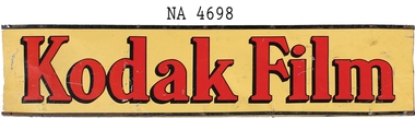
Functional object - Kodak Sign, 1925
Installed on building at 528 Whitehorse Road, Mitcham between 1938 and 1944. Building was a Newsagency and Post Office.Patrick and Bertha Markham operated the newsagency and post office on this site from 1925 to 1944. In the late 30s a range of photographic and developing services and supplies were added to the business. The sign was installed under the veranda on the Whitehorse Road frontage to advertise Kodak services. Also, their daughter Mary was a keen photographer and started a business as a child photographer. In 1944, both her parents died and Mary inherited the premises and continued the Kodak agency as part of her business. Mary and her husband, Harold, sold the former Mitcham post office to the PMG in mid 1957 and removed the Kodak sign as they departed.Metal sign L 1220cm x H 295cm . Yellow background with red lettering 'Kodak Film'. Sign has black edging. Sign is identical both sides.Kodak Filmcommerce, signs -
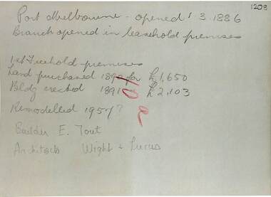 Port Melbourne Historical & Preservation Society
Document - purchase and building costs SSB, Public Records Office Victoria (PROV), 1886 - 1982
The State Savings Bank building was constructed c1891. This note outlines land purchase costa and building costsCOPYRIGHT Public records Office Victoria .03 - 1886 document built environment - commercial, business and traders, state savings bank of victoria -
 Flagstaff Hill Maritime Museum and Village
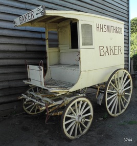
Vehicle - Wagon, H.H. Smith & Co. Baker, Circa 1930s - 1940s
This baker’s wagon or cart transported and delivered bread and other baked goods in the Warrnambool area. It currently has advertising for H.H. Smith & Co. Henry Huntington Smith (1857-1941) owned and operated his Warrnambool bakery in the late 19th and early 20th century. However, the design of the wagon is similar to those used by local bakers in the 1930s and 1940s and probably originated from Stephenson’s Bakery in Warrnambool, which operated around that time. The wagon’s original internal shelves were removed in the early days of Flagstaff Hill so that children could have rides around the village in a horse-driven cart. BAKERS’ HISTORY There were many bakeries in Warrnambool in the 19th to mid-20th century. Each bread bakery made horse and cart deliveries in its allocated zone. SMITH’S BAKERY; – as shown on the wagon’s signage. Henry Huntington Smith (1857-1941) was born and educated in Warrnambool. He worked at Davis’ steam biscuit factory in Timor Street before he began his own bakery business in 1885 near the corner of Fairy and Koroit Streets. A few years later Smith built a new bakery on the corner of Fairy and Lava Street where it still stands today (2025) as Monaghan’s Pharmacy. The building was designed by James McLeod in 1892 as a bakehouse, shop and residence for Smith The address was known locally as Smith’s Corner. Next door to the bakery, at 136 Fairy Street, were stables built by Jobbins and McLeod in 1886 for William Cust. A photograph in the archives of the Warrnambool and District Historical Society shows the 1892 building with four fancy horse-drawn wagons on the street with white-clad drivers and a promotional stand erected with 5 bakers in uniform and the signage “H H Smith & Co, Pastry Cooks and Confectioners”. One of the wagons appears to have “H H Smith” painted on the side. H.H. Smith & Co. placed an Advertisement in the Weekly Times in December 1896 promoting its business as bakers, confectioners and pastry cooks, praising their shop as an ‘ornament to the town’ with ‘neat appointments’ and ‘dainty decorations’. It also boasted of supplying a large number of customers within a twelve-mile radius of Warrnambool. In November 1919 The Warrnambool Standard announced the marriage of Henry H Smith, Mayor of Warrnambool, to Jeannie Samson-Goodman in East Adelaide. In the same newspaper was a notice that Frank Crossley was to open as baker and pastry cook in H.H. Smith’s premises. As well as being the proprietor of the H.H. Smith Bakery, Henry Huntington Smith was a Councillor for the Warrnambool Municipality from 1913 to 1937 and Mayer for two terms. In December 1919 during his first term as Mayor, he was honoured for the work he had done with returning soldiers after World War I, receiving a document in recognition of this work, presented by the Mothers, Wives and Sisters of returned soldiers. Smith was very interested and involved in the community in many roles, including being the Vice President of the first Warrnambool and District Historical Society. STEPHENSON’S BAKERY: – believed to be the past owner of the wagon. The last owner of the bakery was Harold Stephenson. Stephenson was enlisted in the A.I.F. and was invalided home in 1943 before the end of the Second World War. He also served as a Councillor from 1958 to 1976, during which time he served six terms as Mayor for the City of Warrnambool (1966-1973) while he had the bakery. He was very involved in many local organisations including the Warrnambool Surf Life Saving Club and the Road Race Committee. He died in 1985, lauded as being one of Warrnambool’s “most distinguished civic leaders”. It has been said that the baker injured in World War II invented a special contraption to enable him to get up into the wagon and that he alerted his customers that he was in their vicinity by blowing a whistle. The customers would come out and choose their bread from the back of his wagon then pay him for it. However, another account is given by a man who once earned pocket money by helping the baker on his rounds. He says that it was Stephenson, the owner and manager of the bakery, and not the delivery baker who received a significant injury during the war, making him unable to climb the stairs of his upstairs accommodation at the bakery, therefore causing him to sleep downstairs. At this time in the early to late 1940 Stephenson’s bakery had three wagons, one for each of the delivery rounds. The wagons were painted black and yellow. Two of the drivers were Stan Lake and Ali (Alec) Dean who both had wagons with the covered cabin design. The third driver was Bill Lake who had a flat wagon. Stan Lake delivered in the area around Lava and Koroit Streets, Ali Dean had another round and Bill Lake had the Dennington area. Bread continued to be delivered into the 1960s but by this time the delivery vehicles were motorised. The goods produced at Stephenson’s bakery included bread baked in different shaped tins such as High Tin, Sandwich and Vienna. Some shapes were easily divided into half by breaking them apart, therefore the baker could make two-quarter loaves from a half loaf, satisfying different needs. There was the option of white or brown bread, sweet buns, fruit buns and Boston buns. The baker’s assistant was known to take great delight in ‘trimming’ the broken halves of excess bread and crust, enjoying his treat. THE BAKERY PREMISES: – Southeast corner of Fairy and Lava Streets, Warrnambool. The building retains the original cast iron veranda. Above the veranda, a motif of a wheat sheaf in ornamental plaster can be seen. Inside the building, there are still some of the original fittings. The building was classified by the National Trust in August 1979. After the Second World War, an official system of zoning was introduced as a fair way for the baking industry to operate. In 1949 different pricing was introduced by the Government for either delivered or retail purchased bread. Many of the small local bakeries went out of business after the Government banned zoning. The way was made open for the larger bread manufacturers to enter the local market with cheaper prices. Some of those companies were Mc Queens, Tip Top, Twisties, and Sunicrust, (Mc Queens ‘new’ bakery building was where the current Toyworld shop now stands, is, in the Ozone carpark.) O’Grady’s Bakery, later changing hands and known as Burkes Bakery, was on Fairy Street near the Timor Street intersection, on the North West side. There was also a bakery named Almay. The baker’s wagon is significant because of its association with H.H. Smith’s Bakery in Warrnambool.. The H.H. Smith’s Bakery building on the corner of Fairy and Lava Streets, built in 1892, is classified by the National Trust, August 1979. Smith Street Warrnambool was named after Henry Huntington Smith, who was a Warrnambool Councillor 1913 – 1937 and Mayor 1919 – 1921. Baker’s wagon, often referred to as a baker’s cart. Four wheeled horse-drawn delivery wagon, front wheels smaller than rear wheels. Wagon is clad with metal sheets and lined with varnished timber panels. Wheels have metal rims, wooden spokes and rear wheels have wooden brake pads. Horse shaft is timber with metal fittings. Front has a metal lamp holder, brake lever, metal hand grips and decorative metal foot plates. The wagon has suspension leaves on back and sides and double suspension leaves on the front. Driver’s area at front has a roof, glass side windows and wooden box seat with hinged compartment accessing wagon storage area. Door above back of seat has buckled leather handgrip strap attached, door slides open for access to wagon area. Back of wagon has a wooden step and a split door; top door has ventilation louvers, both doors have metal latches. Wagon is painted cream with brown trim and signage and green step. Remnants of red and green paint are visible; underside of seat panel is painted grey. Wagon advertises H.H. Smith & Co. Baker, a Warrnambool business established in 1885, but is of a more modern design seen around 1930’s and 1940’s and most likely belonging to Stephenson's bakery. Brown signwriting on sides of wagon “H.R. SMITH & CO. / BAKER” Brown signwriting across front of wagon “BAKER” warrnambool, shipwrecked-coast, flagstaff-hill, flagstaff-hill-maritime-museum, maritime-museum, shipwreck-coast, flagstaff-hill-maritime-village, shipwrecked-artefact, great ocean road, baker’s wagon, h.h. smith baker, warrnambool, henry h smith, jeannie samson-goodman, frank crossley, mayor of city of warrnambool, vice president of warrnambool and district historical society, stephenson’s bakery warrnambool, harold stephenson, warrnambool surf life saving club, road race committee, national trust building, stan lake, bill lake, ali dean, 19th and 20th century bakers, davies steam biscuit factory warrnambool, james mcleod building designer, jobbins and mcleod, william cust, h h smith & co, pastry cooks and confectioners, bakery trade, bread delivery wagon -
 Mission to Seafarers Victoria
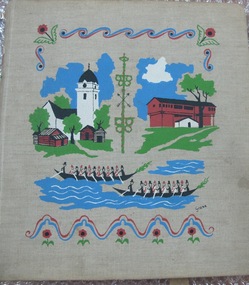
Album - Photographic album, Ports of call with the M/S Mongabarra from December 1st 1949 to July 23rd 1950, 1949
The album tells the story of ports visited by Allan Charles Quinn during his service on board the M/S "Mongabarra". He signed on in San Francisco on December 1, 1949. Note this trip overlapped with the Album (00278) which documents the next trip Quinn made to Africa out of Gothenburg. The album preserves a 1950s perspective of a Merchant Seaman and his experience of the respective Ports at that time. The Collection is especially useful when viewed along with contemporary Quinn family correspondence.Album with metal Metal binder rings at spine and beige fabric cover with gouache printed colour design featuring scandinavian buildings. The album contains 25 pages of b/w mounted photographs. Some are missing. The cover is illustrated with colour screenprinted pictures of a white tower on the left and a brown Barn-like building on the right. There are stylised canoe boats containing rowers in the foreground.. On the inside front cover is a handwritten itinerary of the places visited.On front cover possible designer printed signature in black: "Grane"; On inside front cover on adhered sheet of paper in aqua ink lists intinerary/ index of 20 Ports visited: Title (see above) / "Signed on in San Francisco December 1st 1949 / " then a header line for 4 columns: " PORT COUNTRY ARRIVED DEPARTED / 1. San Francisco U.S.A 10-10-49 4-12-49 / ... / 10. ADELAIDE ... 11-4-50 19-4-50 / .../ 20. HALDEN NORWAY 23-7 - 50 25-7-50" ; Most of the photographs in the Album also annotated and dated ; inside back cover has an embossed letter R.album, photograph, ms mongbarra, san francisco, dunkirk, voyages, allan quinn, barbara quinn, seafaring life, ww2, seafarer, melbourne, sydney, brisbane, san pedro, newcastle, adelaide, port pirie, port lincoln, cape town, las palmas, australia, south africa, canary islands, usa, united states, france, antwerp, belgium, hull, england, hamburg, germany, copenhagen, denmark, gothenburg, norway, sweden, halden, malmö -
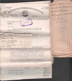 Bendigo Historical Society Inc.
Document - COHN BROTHERS COLLECTION: SWAN HILL FACTORY DOCUMENTS
[a] Cohn Bros red printed 'Return to Sender' manilla envelope with captions' Swan Hill Branch, New factory buildings, Marsh & Michaelson, Mc' Dougall & Ireland, F K Powers to 22/9/ 1944, No 149. [b] Bundle of folded documents relating to Cohn Bros new factory building at Swan Hill, 1944. Marsh & Michaelson Architects, McDougal & Ireland Master Builders. Various costs related to build itemised.bendigo, industry, cohn bros brewery -
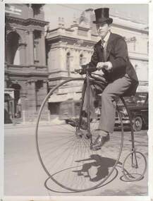 Bendigo Historical Society Inc.
Photograph - YOUNG MALE IN COSTUME RIDING PENNY FARTHING BICYCLE IN PALL MALL, c.1951
Black and white photograph. Young male in costume riding penny farthing bicycle in Pall Mall. Holden car in background. Male wearing cut-away coat & top hat. Portion of bank building w\showing which is (in 2000) Mully's Café. The bank to the R and the Beehive Building at R. Inscriptions: on back 'MP' 190', 'FH 88'. History of object: previous Acc. No. 'MP 190'. James Lerk ' Centenary of Bendigo?'person, individual, centenary, see also 2000.511.01, 2000.512.01, 2000.513.01, 2000.514.01, 2000.515.01, 2000.516.01, 2000.517.01, 2000.518.01, 2000.519.01, 2000.520.01, 2000.522.01.2000.523.01, 2000.524.01 -
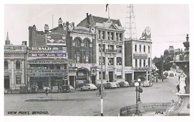 Bendigo Historical Society Inc.
Postcard - VIEW POINT, BENDIGO
black and white photo: View Point, Bendigo. Alexandra Fountain on Rh side, View Street , Armstrong Tyre Service, Australian Mutual Provident Society, Colonial Mutual Life Building, Greyhound Racing buildings in streetscape. Cars parked along kerb. ? Late 1930's early 1940's. On bottom of photo: View Point, Bendigo. No. 14. On back ' Valentine's Post Card, sending you greetings, for address only.Valentine's Post Cardplace, streetscape, view point, view point, alexandra fountain, view street, armstrong tyre service -
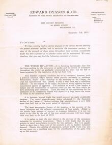 Bendigo Historical Society Inc.
Document - MCCOLL, RANKIN AND STANISTREET COLLECTION: EDWARD DYASON AND CO 'FACTORS AFFECTING ECONOMIC WELFARE/INVESTMENT'
3 page document. Letterhead 'Edward Dyason & Co., member of the stock exchange of Melbourne, Safe Deposit building, 92 Queen St., Melbourne, dated November 7th, 1935. Document is an analysis of the 'world situation' and discusses the economic and political situation of the world . In particular, the equipment industries by ' re-arming programme's 'There is little doubt that the great activity in metal manufactures is partly for war purposes. Despite the building of armaments, nobody really wants war .....'business, mining, mccoll, rankin & stanistreet, metalliferous industries, dyason & co., stock exchange, shares -
 Ballarat Tramway Museum
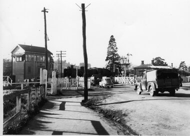
Photograph - Bromide of a b/w photograph, The Courier Ballarat, 1960
Bromide of a black and white photograph of the Humffray St level crossing in 1960 with a steam locomotive passing through the level crossing, with a set of interlocked gates and a number of motor vehicles waiting. Buildings in view are the Ballarat East signal box and the station building, which was demolished in 1962. Was used in Fares Please! September 1990 issue, in an articles "Beware of Trains" by Alan Bradley. Photo by Ballarat Courier. Bromide made c1994 for possible publication, but not used.trams, tramways, ballarat east, humffray st., level crossings, fares please! -
 Ballarat Tramway Museum
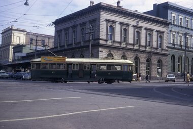
Slide - 35mm slide/s, Peter Moses, Aug. 1971
Photo of SEC Ballarat Tram No. 43 turning from Sturt St. into Lydiard St North with the ANZ Bank building in the background. No. 43 has "Everything's under control in my all electric kitchen" SEC roof advertisement panel. Also in the background is the SEC offices building. Photo shows the Brill 22E trucks turning or curving around the curve. Kodak cardboard mount slide, taken by Peter Moses August 1971.On back of slide in red ink "N43 Ballarat / Turning into Lydiard St." and in bottom right hand corner in black ink "P. Moses" on the reverse side of slidetramways, trams, sturt st, lydiard st, anz, tram 43 -
 Ballarat Tramway Museum
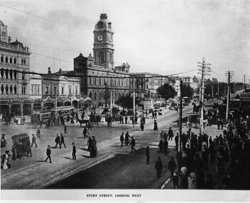
Photograph - Black & White Photograph/s, c1907
Yields information about the City Centre of Ballarat, Sturt and Lydiard Streets in the mid 1900's, just after electrification, the people, vehicles, streetscape and styles of clothing.Black and White copy photograph of a publication photograph of the city centre of Sturt St and Lydiard St Ballarat, c1907, following electrification of the tramway. shows an electric tram hauling a horse trailer, with many people, well dressed crossing the street, following an event. A number of horse drawn vehicles in the view, along with the Town Hall, Snows, the medium strip, the National Mutual building. Also show the telegraph/telephone wires coming into the building. tramways, trams, esco, lydiard st, sturt st, tramway centre -
 Ballarat Tramway Museum
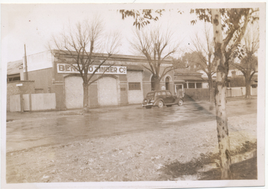
Photograph - Black & White Photograph/s, Wal Jack, 8/08/1943 12:00:00 AM
Black and White copy print contained within the Wal Jack Bendigo and Geelong Album, see Reg Item 5003 for more details. Old Steam tram depot building, Mollison St Bendigo, 8 August 1943, Photo Wal Jack. At the time of the photograph, the building was used by the Bendigo Timber Co. i1 - scan of print in the album i2 - rear of image i3 - scan of negative at 3200dpi added 6/6/2020..1 - On rear in ink "The old depot of the Bendigo Tramways Co. Ltd. Mollison St Bendigo 4-8-43". Has Wal Jack copyright stamp on print. trams, tramways, bendigo, steam trams, depot