Showing 1401 items
matching 1863
-
 Kew Historical Society Inc
Photograph - The Model Dairy Pty Ltd, 1968
This well-known Kew business, which would become known as The Model Dairy, was founded in 1863 by James Venn Morgan. Morgan sold the company in the 1890s to John Simonton who renamed the business The Model Dairy Co. Simonton had experience in the local dairying industry having previously leased the Willsmere Park Dairy. He moved the business to Belmont Avenue in c.1899. In 1924, following his retirement, the company expanded to become The Model Dairy Pty Ltd with Arnold Thompson Simonton and John Tanner as its owner/directors. With new techniques and processes such a pasteurisation, the Belmont Avenue site no longer met required standards for processing and bottling, so its operations moved to 191 Cotham Road. The company celebrated its centenary in 1963. A new factory, built in 1959 to a design by Bates, Smart & McCutcheon, was purchased by Bib Stillwell Motors after the dairy closed. The entire site has since been redeveloped.Original black and white photographic positive of a Model Dairy Truck emerging onto Kent Street, Kew.the model dairy pty ltd, the model dairy co, john simonton, james venn morgan, john tanner, cotham road, kent street, ridgeway avenue, bates smart & mccutcheon, dairies -- kew (vic.) -
 Kew Historical Society Inc
Photograph - The Model Dairy Pty Ltd, 1968
This well-known Kew business, which would become known as The Model Dairy, was founded in 1863 by James Venn Morgan. Morgan sold the company in the 1890s to John Simonton who renamed the business The Model Dairy Co. Simonton had experience in the local dairying industry having previously leased the Willsmere Park Dairy. He moved the business to Belmont Avenue in c.1899. In 1924, following his retirement, the company expanded to become The Model Dairy Pty Ltd with Arnold Thompson Simonton and John Tanner as its owner/directors. With new techniques and processes such a pasteurisation, the Belmont Avenue site no longer met required standards for processing and bottling, so its operations moved to 191 Cotham Road. The company celebrated its centenary in 1963. A new factory, built in 1959 to a design by Bates, Smart & McCutcheon, was purchased by Bib Stillwell Motors after the dairy closed. The entire site has since been redeveloped.Original black and white photographic positive of a Model Dairy Truck parked in Kent Street, Kew.the model dairy pty ltd, the model dairy co, john simonton, james venn morgan, john tanner, cotham road, kent street, ridgeway avenue, bates smart & mccutcheon, dairies -- kew (vic.) -
 Kew Historical Society Inc
Photograph - The Model Dairy Pty Ltd, 1968
This well-known Kew business, which would become known as The Model Dairy, was founded in 1863 by James Venn Morgan. Morgan sold the company in the 1890s to John Simonton who renamed the business The Model Dairy Co. Simonton had experience in the local dairying industry having previously leased the Willsmere Park Dairy. He moved the business to Belmont Avenue in c.1899. In 1924, following his retirement, the company expanded to become The Model Dairy Pty Ltd with Arnold Thompson Simonton and John Tanner as its owner/directors. With new techniques and processes such a pasteurisation, the Belmont Avenue site no longer met required standards for processing and bottling, so its operations moved to 191 Cotham Road. The company celebrated its centenary in 1963. A new factory, built in 1959 to a design by Bates, Smart & McCutcheon, was purchased by Bib Stillwell Motors after the dairy closed. The entire site has since been redeveloped.Original black and white photographic positive of two Model Dairy Trucks in Kent Street, Kew. Barenya Court and Cotham Shopping Centre in distancethe model dairy pty ltd, the model dairy co, john simonton, james venn morgan, john tanner, cotham road, kent street, ridgeway avenue, bates smart & mccutcheon, dairies -- kew (vic.) -
 Kew Historical Society Inc
Photograph - The Model Dairy Pty Ltd, 1968
This well-known Kew business, which would become known as The Model Dairy, was founded in 1863 by James Venn Morgan. Morgan sold the company in the 1890s to John Simonton who renamed the business The Model Dairy Co. Simonton had experience in the local dairying industry having previously leased the Willsmere Park Dairy. He moved the business to Belmont Avenue in c.1899. In 1924, following his retirement, the company expanded to become The Model Dairy Pty Ltd with Arnold Thompson Simonton and John Tanner as its owner/directors. With new techniques and processes such a pasteurisation, the Belmont Avenue site no longer met required standards for processing and bottling, so its operations moved to 191 Cotham Road. The company celebrated its centenary in 1963. A new factory, built in 1959 to a design by Bates, Smart & McCutcheon, was purchased by Bib Stillwell Motors after the dairy closed. The entire site has since been redeveloped.Original black and white photographic positive of Model Dairy Trucks in Kent Street, Kew. Barenya Court and Cotham Shopping Centre in distancethe model dairy pty ltd, the model dairy co, john simonton, james venn morgan, john tanner, cotham road, kent street, ridgeway avenue, bates smart & mccutcheon, dairies -- kew (vic.) -
 Kew Historical Society Inc
Card - Model Dairy Coy: Belmont Avenue, Kew, c.1907
This well-known Kew business, which would become known as The Model Dairy, was founded in 1863 by James Venn Morgan. Morgan sold the company in the 1890s to John Simonton who renamed the business The Model Dairy Co. Simonton had experience in the local dairying industry having previously leased the Willsmere Park Dairy. He moved the business to Belmont Avenue in c.1899. In 1924, following his retirement, the company expanded to become The Model Dairy Pty Ltd with Arnold Thompson Simonton and John Tanner as its owner/directors. With new techniques and processes such a pasteurisation, the Belmont Avenue site no longer met required standards for processing and bottling, so its operations moved to 191 Cotham Road. The company celebrated its centenary in 1963. A new factory, built in 1959 to a design by Bates, Smart & McCutcheon, was purchased by Bib Stillwell Motors after the dairy closed. The entire site has since been redeveloped.Digital copy of a business card advertising the Model Dairy in Belmont Avenue, Kew, managed by John Simonton. (The card was donated by John Harvey Simonton in 2021,)"Milk delivered fresh twice daily in / Kew, Hawthorn & Camberwell / All Milk guaranteed free from chemicals, used either to preserve or colour it / Our butter (Model Dairy Brand) / I Manufactured from Pure Cream by the most improved Machinery / [DRAWING] The Model Dairy Co Belmont Avenue Kew / Model Dairy Co / Belmont Avenue, Kew / John Simonton, Manager"model dairy -- kew (vic.), john simonton, belmont avenue -- kew (vic.), dairies -- kew (vic.) -
 Kew Historical Society Inc
Document - Account for Week ending 22 June 1907
This well-known Kew business, which would become known as The Model Dairy, was founded in 1863 by James Venn Morgan. Morgan sold the company in the 1890s to John Simonton who renamed the business The Model Dairy Co. Simonton had experience in the local dairying industry having previously leased the Willsmere Park Dairy. He moved the business to Belmont Avenue in c.1899. In 1924, following his retirement, the company expanded to become The Model Dairy Pty Ltd with Arnold Thompson Simonton and John Tanner as its owner/directors. With new techniques and processes such a pasteurisation, the Belmont Avenue site no longer met required standards for processing and bottling, so its operations moved to 191 Cotham Road. The company celebrated its centenary in 1963. A new factory, built in 1959 to a design by Bates, Smart & McCutcheon, was purchased by Bib Stillwell Motors after the dairy closed. The entire site has since been redeveloped.Digital copy of the front side of an invoice, for week ending 22 June 1907 by John Simonton of the Model Dairy in Belmont Avenue to Watson for delivery of 17 bottles of milk on six occasions during the week . A drawing of the Model Dairy is printed at the top of the invoice. (The card was donated by John Harvey Simonton in 2021,)"[To M] Watson" / "Paid A Simonton 26/6.07"model dairy -- kew (vic.), john simonton, belmont avenue -- kew (vic.), dairies -- kew (vic.), invoices -
 City of Kingston
Photograph - Colour, Paul Tresize, 1998
The name Mordialloc was derived from the name Moody Yallock, which comes from the Bunurong language. The Bunurong Peoples are the Traditional Owners of this area. The name means “high water” or “high creek”. In 1839, colonial authorities declared the mouth of the creek, and an additional 830 odd acres as an Aboriginal Reserve, although this proclamation was never gazetted. The reserved land included part of the Carrum Carrum Swamp which was abundant with wild life and natural resources. Regular encroachments, including land sales which began in 1863, were made on the land until 1878 when the Reserve was declared closed, and the land was opened up to land sales. Market gardening and suburban house lots quickly began to develop, and Mordialloc became a renowned picnic and holiday site. Mordialloc Creek is a popular bay side destination for local and visitors, and is a site for boating, kayaking, fishing and swimming, along with many other activities.Colour photograph of Mordialloc Creek, looking out to the bay. Many small fishing and leisure craft are moored on either side of the banks of the creek. To the right hand side can be seen parklands, while the left hand side has a small inlet in which more small crafts are moored.mordialloc, bunurong, traditional owners, suburbs, boats, fishing, waterways -
 City of Kingston
Photograph - Colour, 1998
The name Mordialloc was derived from the name Moody Yallock, which comes from the Bunurong language. The Bunurong Peoples are the Traditional Owners of this area. The name means “high water” or “high creek”. In 1839, colonial authorities declared the mouth of the creek, and an additional 830 odd acres as an Aboriginal Reserve, although this proclamation was never gazetted. The reserved land included part of the Carrum Carrum Swamp which was abundant with wild life and natural resources. Regular encroachments, including land sales which began in 1863, were made on the land until 1878 when the Reserve was declared closed, and the land was opened up to land sales. Market gardening and suburban house lots quickly began to develop, and Mordialloc became a renowned picnic and holiday site. Mordialloc Creek is a popular bay side destination for local and visitors, and is a site for boating, kayaking, fishing and swimming, along with many other activities.Colour photograph of Mordialloc Creek, looking inland.Small fishing and leisure boats are moored on either side of creek, with a view of the Mordialloc Bridge Hotel in the background.mordialloc, bunurong, traditional owners, suburbs, boats, fishing, waterways, hotel -
 City of Kingston
Photograph - Colour, Paul Tresize, 1998
The name Mordialloc was derived from the name Moody Yallock, which comes from the Bunurong language. The Bunurong Peoples are the Traditional Owners of this area. The name means “high water” or “high creek”. In 1839, colonial authorities declared the mouth of the creek, and an additional 830 odd acres as an Aboriginal Reserve, although this proclamation was never gazetted. The reserved land included part of the Carrum Carrum Swamp which was abundant with wild life and natural resources. Regular encroachments, including land sales which began in 1863, were made on the land until 1878 when the Reserve was declared closed, and the land was opened up to land sales. Market gardening and suburban house lots quickly began to develop, and Mordialloc became a renowned picnic and holiday site. Mordialloc Creek is a popular bay side destination for local and visitors, and is a site for boating, kayaking, fishing and swimming, along with many other activities.Colour photograph of Mordialloc Creek, looking inland. Boats are moored on either side of the creek and the Bridge Hotel is visible in the background.mordialloc, bunurong, traditional owners, suburbs, boats, fishing, waterways, hotel -
 City of Kingston
Photograph - Colour, Paul Tresize, 1998
The name Mordialloc was derived from the name Moody Yallock, which comes from the Bunurong language. The Bunurong Peoples are the Traditional Owners of this area. The name means “high water” or “high creek”. In 1839, colonial authorities declared the mouth of the creek, and an additional 830 odd acres as an Aboriginal Reserve, although this proclamation was never gazetted. The reserved land included part of the Carrum Carrum Swamp which was abundant with wild life and natural resources. Regular encroachments, including land sales which began in 1863, were made on the land until 1878 when the Reserve was declared closed, and the land was opened up to land sales. Market gardening and suburban house lots quickly began to develop, and Mordialloc became a renowned picnic and holiday site. Mordialloc Creek is a popular bay side destination for local and visitors, and is a site for boating, kayaking, fishing and swimming, along with many other activities.Colour photograph of Mordialloc Creek with boats moored on both sides of the street and Pompei's boat yard visible on the right hand side of the creek., Main Street and St Brigid's Catholic Church are visible in backgroundmordialloc, bunurong, traditional owners, suburbs, boats, fishing, waterways, hotel, church -
City of Kingston
Photograph - Colour, Paul Tresize, 1998
The name Mordialloc was derived from the name Moody Yallock, which comes from the Bunurong language. The Bunurong Peoples are the Traditional Owners of this area. The name means “high water” or “high creek”. In 1839, colonial authorities declared the mouth of the creek, and an additional 830 odd acres as an Aboriginal Reserve, although this proclamation was never gazetted. The reserved land included part of the Carrum Carrum Swamp which was abundant with wild life and natural resources. Regular encroachments, including land sales which began in 1863, were made on the land until 1878 when the Reserve was declared closed, and the land was opened up to land sales. Market gardening and suburban house lots quickly began to develop, and Mordialloc became a renowned picnic and holiday site. Mordialloc Creek is a popular bay side destination for local and visitors, and is a site for boating, kayaking, fishing and swimming, along with many other activities.Colour photograph of Mordialloc Creek with boats moored on both sides of the street and Pompei's boat yard visible on the right hand side of the creek., Main Street and St Brigid's Catholic Church are visible in background.mordialloc, bunurong, traditional owners, boats, fishing -
 Sunbury Family History and Heritage Society Inc.
Photograph, Vineyards - Ben Eadie and Craiglee, 1903
The two homesteads are Ben Eadie and Craiglee, which were two of Sunbury's earliest vineyards that were established in Sunbury. James Stewart Johnson designed and built his concrete home, Craiglee, in 1865 where the previous year he had planted out his vineyard on the surrounding 26 acres of land.The property was on the east side of Jacksons Creek on Macedon Road. He concentrated growing Riesling and Hermitage grapes. After his death in 1896, his son Wilfred continued to produce wines until the late 1920s, when he pulled out the vines and concentrated on raising sheep for wool and meat. The Carmody family purchased the property in 1961 and in 1976 decided to replant the vineyard. Ben Eadie was built some time in 1863 and settled by the Eadie family who also were millers. The winery was built into the side of a hill close to the house but the Eadie family tended to concentrate on milling and retailing.In the earliest days of European settlement many wineries were established in the Sunbury area.Two non-digital sepia photographs have been mounted on cardboard. They are photographs of two homesteads with bare hills in the background. They were built in Sunbury in the early days off European settlementBen Eadie Vic. Craiglee Sunbury 1903john eadie, ben eadie winery, james stewart johnson, craiglee, wineries, vineyards -
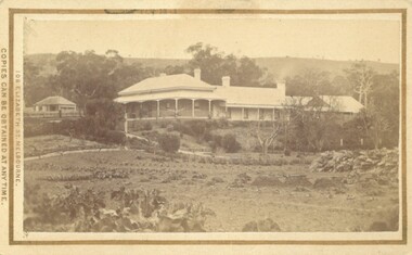
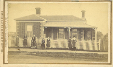 Bacchus Marsh & District Historical Society
Photograph, Home and surgery of Doctor Rae, Bacchus Marsh 1883
This image is one of a series of photographs taken by Melbourne based photographers Stevenson and McNicoll who visited Bacchus Marsh and its nearby districts between September and November 1883. The photo is of a brick residence, built in 1865-66 as a house and surgery for Dr. Rae, a medical practitioner in Bacchus Marsh 1863-1874. Dr. Rae was influential in community affairs as a Justice of the Peace, a member of the Board of Advice of Bacchus Marsh Common School and a President of the Mechanics’ Institute. After ill health forced him to resign his practice, he built the Bungalow in 1880, where he lived until his death. The house was later purchased by William Anderson (c.1880) who named it “Dunglass”. The people in this photograph are probably members of the Anderson family. The house is now used as an Adult Education Centre. The house is of significance as the embodiment of the importance to the community of its influential figures, such as Dr. Rae, in the late nineteenth and early twentieth centuries. Small sepia 'carte de viste' style unframed photograph on card with gold border framing photograph. Housed in the Jeremeas Family Album which contains photographs of Bacchus Marsh and District in 1883 by the photographers Stevenson and McNicoll. The photo is of a double-fronted brick Classical nineteenth century house with a high hip roof. Two brick chimneys are visible. The left hand bay is set forward, with the central section of the house being set back. A concave return verandah supported by decorative columns runs along the front and side of the house, leading to a separate entry door off the side verandah. On the window set in this door, the word ‘SURGERY’ can be discerned, indicating that this is the entrance to be used by patients. The building features buff-coloured stone quoins and architraves. A white picket fence runs along the front. Ranged along the footpath in front of the fence stands a group of eight young women and girls. A flat stone acts as a bridge over a deep drainage culvert running parallel to the street.Printed On the front: Stevenson & McNicoll. Photo. 108 Elizabeth St. Melbourne. COPIES CAN BE OBTAINED AT ANY TIME. On the back: LIGHT & TRUTH inscribed on a banner surmounted by a representation of the rising sun. Copies of this Portrait can be had at any time by sending the Name and Post Office Money Order or Stamps for the amount of order to STEVENSON & McNICOLL LATE BENSON & STEVENSON, Photographers. 108 Elizabeth Street, MELBOURNE. stevenson and mcnicoll 1883 photographs of bacchus marsh and district, doctors, houses bacchus marsh -
 Bendigo Historical Society Inc.
Book - JOAN O'SHEA COLLECTION: 150TH ANNIVERSARY OF BENDIGO BOOKLET, 1850 - 1950's
Joan O'Shea Collection. Buff Coloured Booklet City of Bendigo. 150th anniversary of Bendigo 1850s to 1950s. Image on cover coat of arms for City of Bendigo underneath word progress, left hand side horse, right hand side bullock. History of Bendigo: From Sheep Run to Provincial City in 100 years. Map of Bendigo and Surrounds Railways, Water Courses & Storage, Power, Municipal Boundaries & Land Available for Industry. Municipal District Creation 1855, Borough Proclamation 1863, Proclaimed City 1871, Area: 7992 Acres Population as of last census City of Bendigo 28,722, City of Bendigo and adjacent Urban Areas 36,909. City of Bendigo Map, The Past Prior to 1850. Icons of Bendigo The Bendigo base Hospital,Law Courts & Post Office, Primary Schools, Housing, Industry including Butter Production, Poultry Farming, Livestock Sales & Tomato Growing, Slaughter House & ordnance factory. The Present Recreation Photos: Bendigo Bowling Club, Queen Elizabeth Oval, Municipal Lawn Tennis Courts The Future of Bendigo, Bendigo Photographs From The 1950s,Cambridge Press Bendigobendigo, history, progress of bendigo 1850s on. -
 Bendigo Historical Society Inc.
Document - ALBERT RICHARDSON COLLECTION: TAMBOUR MAJOR AND CHRISTMAS LINE OF REEF
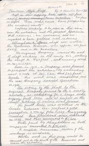
Three page document. Front page, extracts from F. Chamber's Report on Tambour Major Shaft, includes reference to Allingham and Moore's shaft and Specimen Hill Reservoir. Early workings on the Christmas Reef line, Specimen Hill or Tambour Major, are listed in a table format, example - Great Western Gold Mining and Crushing Coy, 1855 Fajeon and Coy, 1859, tunnel in hillside. Specimen Hill Coy 1861 Indefatigable 1862, 64, 67 - 1881 Agamemnon 1862-1863 - 1881 Invincible Co. 1865 - 1867 Old Bendigo Tribute 140 ft 1870 Great Eastern Co 1870 - 1881 Great Eastern Tribute Co. Bismark Co, No. 1 North 150 ft 1870 - 1881 Bismark No. 2 Tribute 212 ft Allingham and Moore 338 ft 1872 Specimen Hill United 450 ft 1881 Great Western United (amalgamation of Old Bendigo, Invincible, Gt. Eastern and Bismark Coys) 400 ft 1882 Tambour Major 847 feet 1881 - 1890 Christmas Reef Co. 200 ft. 1895 - 1897 Open Cutsbendigo, mining, christmas reef gold mining -
 Flagstaff Hill Maritime Museum and Village
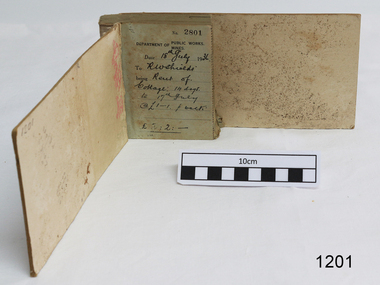
Financial record - Receipt Book, Department of Works and Mines Victoria, July 1936 (first record)
Establishment and Functions Prior to 1860, the Chief Secretary's Department had been responsible for the administration of the gold fields and associated mining activities. In November 1860 a Commissioner of Mines was appointed and a Department was established under his administration. For the period November 1861 to June 1863, the Postmaster General was responsible for the Mining Department. A Minister of Mines was again appointed in 1863. Responsibilities of the Department of Mines were: 1. Regulation of mining and related public works activities through the issue of miners rights, business and residence licences, mining leases, mineral and other prospecting licences 2. Superintendence of the activities of mining surveyors, registrars, wardens and Mining Boards. 3. Investigation of the state's geological structure, mineral wealth and underground water resources 4. Development of the mining industry 5. Supervision of the safe working of mines, machinery and quarries including checking the credential of mine managers, inspectors and operators 6. Regulation of the disposal of sludge and other waste products 7. Administration of the Victorian Mining Accident Relief Fund. Arising from its initial responsibility for the supply of water on the gold fields, the Department became responsible for rural water supply from the mid 1860s. Statutory responsibility for rural water works during this period rested with the Board of Land and Works. In 1865 the Waterworks Act gave the Board power to construct waterworks, purchase land, levy charges and lease or sell works, while the Public Loans Act 1865 empowered it to provide loans to local water trusts for waterworks. The actual administration of these statutory provisions was undertaken by the Victorian Water Supply Department which operated from 1865 to 1889 as a sub-department of the Department of Mines, from 1889 as a department in its own right, and from 1895 to 1909 as a sub-department of the Department of Mines and Water Supply. For a brief period from 1891 to 1893 the Department of Mines was also responsible for forests and, until 1880, for the Schools of Mines subsequently transferred to the Education Department. In 1895 the Department of Mines and the Victorian Water Supply Department were amalgamated to form the Department of Mines and Water Supply. A snapshot into social history around the 1930s when the Department of works and the Mines Departments were still linkedReceipt Book for the Department of Works; Mines. Receipt No 2801 - 3000. 1st receipt Number 2801, "18th July 1936, for Rent of Cottage: 14 days for 2 pounds, 2 shillings. The inscription on the back is signed by J F Condau in 13-3-33Printed on spine "GENERAL RECEIPTS / 15 / 2801 / TO 3000" Printed on each receipt 'DEPARTMENT OF / PUBLIC WORKS. / MINES." Fill in using ink pen "(DATE) 18th July 1936 / (TO) - - - shields' / BEING) Rent of / Cottage: 14 days / (TO) 17th July / @ (symbol for pound) 1-1. p. week / . (symbol for pound) 2:2:-"Inside cover there is some red pencil writing, words and figures unreadable. Handwritten on back cover "Numbers checked / and found corredt / J S Coudou (?) / 13-3-33" One some receipts "Wharfage / S.S. Koonara"flagstaff hill, warrnambool, shipwrecked coast, flagstaff hill maritime museum, maritime museum, shipwreck coast, flagstaff hill maritime village, great ocean road, department of works: mines, receipt book, rent 1936, imperial currency, living costs 1936, department of works, department of mines, j f condou, 1933, 13-3-33 -
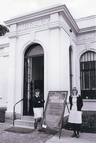 The Beechworth Burke Museum
Photograph, c.1980
This photograph depicts the entrance to the Burke Museum in Beechworth, most likely in 1980. The building was originally established as the Beechworth Athenaeum in 1857 to provide a lecture hall and reading room at the peak of the gold rush. In 1859, it became the Beechworth Public Library, which is why the writing embossed above the main entry says 'Library' rather than 'Museum'. The building was turned into a museum and renamed the Robert O'Hara Burke Memorial Museum in 1863 in honour of Robert O'Hara Burke, former Police Superindendent of Beechworth who died in 1861 on the Burke and Wills expedition. The Burke Museum has been in almost continual operation since that time. In the 1970s, the building underwent renovations to create several verandas, though the main façade visible in this photograph remained as it was when originally built. The Burke Museum currently contains over 30,000 individual objects, including the Gold Rush era items and the Ned Kelly collection advertised on the a-frame in the photograph. The photograph itself is also part of the Burke Museum collection.The Burke Museum itself is very significant to Victorian history. It is on both the Victorian Heritage Register and is part of the National Trust due to its relevance to the history of the Gold Rush period, its architectural features, and its significant collection. Photographs of it throughout its history are an important part of telling the museum's story. This photograph in particular highlights what the museum staff believed would be appealing to a 1980s public, evident by the A-frame advertising board.A black and white rectangular photograph printed on photographic paper.Top right text: 5147. Bottom left text: Beryl Seatt (or possibly Scatt) & friend 1980beechworth, burke museum, beechworth museum, beechworth historic precinct, architecture, museum, library, 1980s, 1980s australia, museum staff -
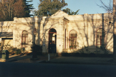 The Beechworth Burke Museum
Photograph
This photograph depicts the façade of the Burke Museum in Beechworth. Originally built in 1857 by the Young Men's Association as the Beechworth Athenaeum, the building provided a public lecture hall and reading room for men at the peak of the gold rush era of Beechworth. In 1859, it became the Beechworth Public Library, which is why the writing embossed above the main entry says 'Library' rather than 'Museum'. The building was turned into a museum and renamed the Robert O'Hara Burke Memorial Museum in 1863 following the death of Robert O'Hara Burke on the Burke and Wills expedition in 1861, as Burke had been the Police Superintendent of Beechworth. The museum has had several additions built onto the property, most notably significant extensions in the 1970s, but the main façade depicted in the photograph has remained largely intact. The architecture is an example of provincial conservative classicism. The Burke Museum contains over 30,000 individual objects, including Gold Rush era items, taxidermy specimens, a Ned Kelly collection, and this very photograph.The Burke Museum itself is very significant to Victorian history. It is on both the Victorian Heritage Register and is part of the National Trust due to its relevance to the history of the Gold Rush period, its architectural features, and its significant collection. Photographs of it throughout its history are an important part of telling the museum's story. Although this is a modern photograph, it captures the façade of the building with similarity to the mid-nineteenth-century provincial conservative classicism style.A colour rectangular photograph printed on photographic paper.3440.1burke museum, beechworth, beechworth museum, australian museum, museum, architecture, classical architecture, conservative classicism, museum facade, library -
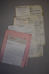 Warrnambool and District Historical Society Inc.
Document, Letters & Minutes, 1960s
These documents contain information about the Warrnambool Racing Club in the 1960s. Race meetings were held in Warrnambool as early as 1848, a few months after the first white settlers arrived. The Warrnambool Racing Club was formed in 1854 and the present day racecourse was first used in 1858. In 1872 the well-known Warrnambool Grand Annual Steeplechase was first held. These documents came from the office of Rolf Crawley, a surveyor, architect and engineer in private practice in Warrnambool and also the engineer for the Shire of Warrnambool from 1935 to 1968. His grandfather, father and uncle were also engineers, working in that capacity or as the Shire Secretary for the Shire of Warrnambool, with the Crawley family recording a total of 132 years of service to the Shire. The Shire of Warrnambool existed from 1863 to 1994. These documents came into the possession of Michael Hand who took over the private surveying practice in Warrnambool of Rolf Crawley. The Warrnambool and District Historical Society acquired these documents, along with several ledgers and other Crawley memorabilia, from the estate of Michael Hand. These documents are of interest as they contain much information on the Warrnambool Racing Club and will be of assistance to researchers.This is a collection of documents relating to the Warrnambool Racing Club. They are typewritten letters and Minutes summaries. Some are copies and there are two cards giving notice of meetings. rolf crawley, warrnambool, warrnambool racing club, shire of warrnambool -
 Victoria Police Museum
Police stations (Aitken's Gap)
Aitken's Gap, otherwise known as The Gap or Buttlejork, and 3km west of Sunbury, was established as a township in 1845. It is in the area which is now bordered by the Calder Highway and Gap Road. The village was named after John Aitken, a Port Phillip pastoralist who took up the Mount Aitken run in 1836. Aitken's Gap Police Barracks (in the District of Bourke) opened in 1853 and was staffed by two Mounted Constables and one Foot Constable. The gaol (used to house prisoners and also gold en route to Melbourne) was built in 1857 from bluestone quarried in the area. The roof was made of slate. In 1861 it was staffed by 1 Mounted Senior Constable and 1 Foot Constable. The Barracks closed in 1863 when the Bendigo rail line was completed and the gold was transported to Melbourne by rail. All the buildings, except the gaol, were moved to Sunbury. The land was sold in 1870 and in 1989 the current owner donated the building to the Sunbury Police. The original building was dismantled, restored and rebuilt outside Sunbury police station.15 colour photos and 1 black and white photopolice stations; aitken's gap police station -
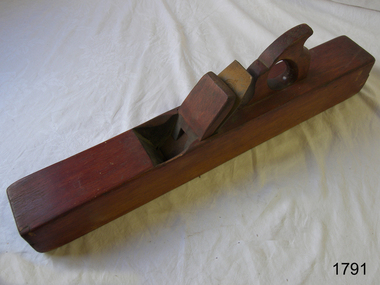 Flagstaff Hill Maritime Museum and Village
Tool - Joiner, Jack or Smoothing Plane, Akin & Son, 1900 to 1966
The subject item is a smoothing plane traditionally wood planes were blocks of wear resistant hardwood, often beech or maple, which were worked to the shape of the intended moulding or had a flat blade use for achieving a flat and smooth finish to timber. The blade, or iron was likewise formed to the intended moulding profile or for smoothing and secured in the body of the plane with a wooden wedge. A traditional cabinetmakers shop might have many, perhaps hundreds, of moulding and flat bladed planes for a full range of work to be performed. Large crown mouldings required planes of six or more inches in width, which demanded great strength to push and often had additional peg handles on the sides, allowing the craftsman's apprentice or other worker to pull the plane ahead of the master who guided it. The maker Atkin and Sons were a prolific Birmingham plane maker, active from 1863 to 1900 when they became Atkin and Sons Ltd and traded until 1966. Their trademark was actually "BENEFACTUM" which is Latin for "well made."A well-made tool from the early 20th century from a well-known company that ceased trading in Birmingham in 1966, today this tool from this company is quite rare and sought after by collectors. It gives us a snapshot of how furniture and other decorative finishes as well as smoothing timber projects were created by the use of hand tools. Tools that were themselves handmade shows the craftsmanship used during this time not only to make a tool such as the subject item but also the craftsmanship needed to finish timber.Jointer or Jack Plane with fishtail handle, Size of iron 2 1/2 inches wide, Stamped GN inside W made by Akins and Sons Birmingham UKflagstaff hill, warrnambool, shipwrecked-coast, flagstaff-hill, flagstaff-hill-maritime-museum, maritime-museum, shipwreck-coast, flagstaff-hill-maritime-village, jointer plane, plane -
 Flagstaff Hill Maritime Museum and Village
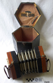
Instrument - Concertina, Lachenal and Co, 1879-1933
Louis Lachenal manufactured concertinas for C Wheatstone & Co. from around 1848-1858 in a combined home and manufactory in Cheswick, England. He then establish up his own business 'Lachenal's' at 8 Little James Street in London. In 1863 the firm began advertising both 'Anglo and English concertinas, which were more expensive. Lachenal passed away in 1861, so his wife Elizabeth took over the business. The firm was sold to a group of five businessmen in about 1873 and in 1874 the firm became ‘Lachenal & Co.’ A Trade Mark application was made by Richard Ballinger on behalf of Lachenal & Co. on 31st August 1878 and the Number 19,555 was published in the Trade Mark Journal January 8, 1879. The symbol was an English-style reed-shoe with the words 'Trade Mark' and 'English Make'. It was stamped on the right-hand rail (handle) of the Lachenal Anglos, to distinguish them from the German-made ones. It seems that the company ceased business in 1933.This concertina, made in the late 19th to early 20th century, represents the portable musical entertainment of the early settlers in the colony of Australia. Concertina, six sided, 21 buttons, with fitted case. Wooden ends have carved cut-outs and leather straps attached to brass buttons. Five-fold bellows have light coloured sides with reinforced edges and corners. Constructed with steel reeds and bone key-buttons. Wooden, black fabric-covered hexagonal case with triangular metal catch, two brass hinges, leather handle and faded red lining. Inscriptions on label inside lid and on wooden ends of bellows. Lachenal, Anglo design, made by Lachenal & Co. of London. Label within oval cut-out "LACHENAL & Co / PATENT CONCERTINA / MANUFACTURERS / LONDON", Label inside lid " - CHENAL -", Impressed into wood STEEL REEDS", "ENGLAND", "TRADE MARK ENGLISH MAKE [reed-shoe symbol]" , (originally marked with Number "98030" )flagstaff hill, warrnambool, shipwrecked-coast, flagstaff-hill, flagstaff-hill-maritime-museum, maritime-museum, shipwreck-coast, flagstaff-hill-maritime-village, concertina, squeeze box, musical instrument, london, english make, trade mark 15222, english-style reed, richard ballinger, louis lachenal, concertina manufacturer, reed-shoe, lachenal anglo, lachenal & co, lachenal -
 City of Moorabbin Historical Society (Operating the Box Cottage Museum)
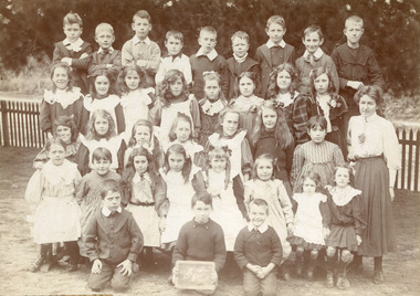
Photograph, Black & White West Beaumaris (Cheltenham) State School Grade 3 1908, 1908
Stephen Charman, 1821-1906 a market gardener, donated land for the first Methodist Chapel, Cemetery and School in Charman Rd Cheltenham 1855. The enrolment was 36 pupils with Mr Frederick Meeres as Teacher. 1863 the school is called Beaumaris Common School No 84 with 70 pupils and Walter Meeres as Teacher. 1869 another 2 acres in Charman Road were granted by the Education Board and brick building built . 1872 State School 84 Beaumaris was increasing enrolments and 1878 a new brick school was built to accommodate 174 pupils and the name changed to Cheltenham State School No.84 1894 Mentone State School No.2950 amalgamated with Cheltenham SS No.84. 1910 the buildings were in disrepair, overcrowding was increasing and renovations were made 1912 with further additions in 1925 and 1937. Post WW11 extra prefabricated Classrooms were added as enrolment increased to 1038 in 1955.. Cheltenham East State School 4754 was opened as housing development spread over the City of Moorabbin . (J.Larson Sandringham HS) 1855 Stephen Charman donated land to the Methodist Church so that a School could be established to educate the children of the early settler market gardeners and farmers in the Cheltenham area . Education was valued by the general community and as well as schools they established mechanics Institutes and Libraries in Moorabbin Shire. Cheltenham State School No. 84 was among the first schools in MelbourneBlack & White photograph of Class 3 pupils at West Beaumaris (Cheltenham )State School 1908Front Handwritten - B.Wooff ---- T.Moodie,- R.Whelan - / 1908 Back Handwritten - Beaumaris, / Mrs White / Mrs Taylorcity of moorabbin, county of bourke, moorabbin roads board, parish of moorabbin, shire of moorabbin, henry dendy's special survey 1841, were j.b., bent thomas, o'shannassy john, king richard, charman stephen, highett william, ormond francis, maynard dennis, cheltenham state school no.84, methodist chapel cheltenham, methodist school cheltenham, beaumaris west state school, meeres frederick, meeres walter, education, early settlers, cancel -
 City of Ballarat Libraries
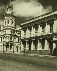
Photograph, Craig's Royal Hotel & Union Bank of Australia Building, Lydiard Street South, Ballarat
An image from the Herbert Richmond collection, gifted in 1982 to the Ballarat Library. The collection contains approximately 200 photographs of Ballarat and district in the 1940s, 50s and 60s, as well as photo albums, glass negatives and other memorabilia. Herb Richmond was a keen photographer, a foundation member and a life member of the Ballarat Camera Club, and a photographer with the Ballarat Courier during the 1940s. The Ballarat Camera Club named an annual award after him. Mr Richmond died in 1981 aged 79. These images were digitally re-photographed by members of the Ballarat Camera Club in September 2006. The first site to be sold in Ballarat, where in 1853 Thomas Bath erected a timber building for use as a hotel. Parts of the present hotel date from 1862, when Walter Craig was owner. The hotel is associated with many historic figures, and no other hotel in Victoria has such an interesting succession of buildings and additions. The former Union Bank of Australia building was designed by Leonard Terry, the renowned bank architect, and was erected in 1863-4.lydiard street south, craig's royal hotel, union bank of australia, terry, leonard -
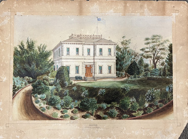 Kew Historical Society Inc
Work on paper, Madford: the property of A.S. King Esq
The Victorian-era mansion Madford in Wellington Street had several incarnations before it was finally demolished. While the precise details of its original construction have not been discovered, we know that it was originally named Elm Lodge, and that the property was offered for sale in 1863 by Thomas Mitchell, of the firm Mitchell & Bonneau, wholesale ironmongers and merchants. The house was sold in about 1873 to William Siddeley (1827-1905), who was described on the occasion of his death as ‘the father of Australian shipping’. The next owner was Arthur Septimus King (1827- 99), who renamed the house Madford after his purchase of the property in 1875. It was A.S. King for whom this artwork was completed. Following King’s death in 1899, portions of the property were sold, including to the Borough of Kew in 1905, to form the Alexandra Gardens. Then, in 1920, the house and its remaining lands were sold to the Catholic Church who opened St Anthony’s Home for Children on the site in 1922. That building was promptly demolished, and the site redeveloped circa 1976.Gift of James Pearson, 2022This fine perspective drawing of the architectural elements of Madford [formerly Elm Lodge, later St Anthony's Home for Babies] is contrasted with the freer addition in watercolour of the layout and plants of the garden facing Wellington Street. The view selected is the south-facing main facade and the west facing side. After A.S. King purchased the house in 1875, it was extended with new wings at the rear to accommodate his large family. There is no indication of these extensions in the painting so its creation must predate the renovations, and probably depicts the original building on the site."MADFORD / The Property of A. S. KING Esq"elm lodge, madford, st anthony's home for babies, houses -- wellington street -- kew (vic.), thomas mitchell, william siddeley, arthur septimus king -
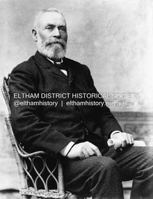 Eltham District Historical Society Inc
Photograph, Ewen Hugh Cameron (1832-1915), c.1910
Ewen Hugh Cameron (1831- 27 September 1915) was born at Kilmonivaig, Inverness Scotland. He migrated to Melbourne in “The Hurricane” in 1853 and in 1855 tried his luck at the newly-opened Andersons Creek Goldfield. Two years later he was appointed first postmaster at Warrandyte and ran the store there. In 1863 he took up the 100 acre farm “Pigeon Bank” at Kangaroo Ground where he lived until his death. In 1874 Cameron was elected as the Member for Evelyn in the Victorian Legislative Assembly and held the seat until he retired in 1914 as “Father of the House”. He held a number of ministerial and other important Parlimentary positions. The most notable was Chairman of the Railways Standing Committee, which was responsible for much of the Railway development in Victoria. Concurrently with his Parliamentary career, he was a member of the Eltham Roads Board and later Council for more than 50 years. In 1867 he married Agnes Bell, a daughter of Kangaroo Ground pioneers. They had eight sons and three daughters. This photo forms part of a collection of photographs gathered by the Shire of Eltham for their centenary project book,"Pioneers and Painters: 100 years of the Shire of Eltham" by Alan Marshall (1971). The collection of over 500 images is held in partnership between Eltham District Historical Society and Yarra Plenty Regional Library (Eltham Library) and is now formally known as the 'The Shire of Eltham Pioneers Photograph Collection.' It is significant in being the first community sourced collection representing the places and people of the Shire's first one hundred years.Digital image B&W printsepp, shire of eltham pioneers photograph collection, kangaroo ground, e.h. cameron, member for evelyn, victorian parliament, legislative assembly, ewen cameron, ewen hugh cameron, ewan hugh cameron, people, pigeon bank -
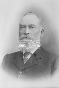 Eltham District Historical Society Inc
Photograph, The Hon. Ewen Hugh Cameron, Member for Evelyn in Legislative Assembly, Victorian Parliament, for 40 years from 1874-1914
Ewen Hugh Cameron (1831- 27 September 1915) was born at Kilmonivaig, Inverness Scotland. He migrated to Melbourne in “The Hurricane” in 1853 and in 1855 tried his luck at the newly-opened Andersons Creek Goldfield. Two years later he was appointed first postmaster at Warrandyte and ran the store there. In 1863 he took up the 100 acre farm “Pigeon Bank” at Kangaroo Ground where he lived until his death. In 1874 Cameron was elected as the Member for Evelyn in the Victorian Legislative Assembly and held the seat until he retired in 1914 as “Father of the House”. He held a number of ministerial and other important Parlimentary positions. The most notable was Chairman of the Railways Standing Committee, which was responsible for much of the Railway development in Victoria. Concurrently with his Parliamentary career, he was a member of the Eltham Roads Board and later Council for more than 50 years. In 1867 he married Agnes Bell, a daughter of Kangaroo Ground pioneers. They had eight sons and three daughters.This photo forms part of a collection of photographs gathered by the Shire of Eltham for their centenary project book, "Pioneers and Painters: 100 years of the Shire of Eltham" by Alan Marshall (1971). The collection of over 500 images is held in partnership between Eltham District Historical Society and Yarra Plenty Regional Library (Eltham Library) and is now formally known as the 'The Shire of Eltham Pioneers Photograph Collection.' It is significant in being the first community sourced collection representing the places and people of the Shire's first one hundred years.Digital imagesepp, shire of eltham pioneers photograph collection, kangaroo ground, e.h. cameron, member for evelyn, victorian parliament, legislative assembly, ewen cameron, ewen hugh cameron -
 Bacchus Marsh & District Historical Society
Photograph, Glenmore Homestead 1883
This homestead was built by Charles Griffith on a 55,000 acre Run. It replaced an earlier dwelling which was a slab hut with a bark roof. Charles Griffith, an Irish barrister, with his friend, James Moore, settled on Glenmore Station in the Parwan Valley in 1840. Their partnership lasted until 1848. In 1846, whilst in Ireland, Griffith married Miss Jane Catherine Magee, then returned to Glenmore and later took his nephew, Molesworth Richard Greene, into partnership, which arrangement proved to be long and prosperous. In 1857, they bought runs at Mount Hope and Mount Pyramid, which they kept until the days of free selection. Griffith led an active and successful public life.He was a member of the new Victorian Legislative Council in 1851, and was later an elected representative of the Legislative Assembly 1853-1859. He occupied many important public positions, including that of magistrate for Bacchus Marsh. Griffith was a devout Anglican and hosted Bishop Charles Perry at his station near Bacchus Marsh in 1849. He died in 1863 at his home in South Yarra.Small sepia unframed photograph on card with gold border framing photograph. Housed in the album, 'Photographs of Bacchus Marsh and District in 1883 by Stevenson and McNicoll'. The photograph shows a view of an extensive single-storey homestead consisting of three adjoining buildings, with a further building on the left of the main property. The series of three buildings is built in an elevated position, with pathways leading through a garden. At the front there is a vegetable garden which seems to be still in a state of development. The main house, possibly of brick, is set at an angle to the other two in this complex. It has a hip roof with a concave verandah on two sides with arched barge boards and simple unadorned pillars. There appears to be a hammock slung between two pillars. Two chimneys can be seen on this dwelling.The adjoining building is of a simpler design, with a lower roof line and a verandah running along the front. Two chimneys can be seen, one emitting smoke. This middle building may be a kitchen and rooms for day-to-day use. The third building is also of a simpler design, with a gable above a verandah. The purpose of this building is less clear. The different styles of construction suggest that these buildings were built separately at different times for different purposes. To the left of the main group of buildings is another cottage, smaller and of a simpler design. A fence runs along the front, clearly separating this building from the others, suggesting it may have been the dwelling of an overseer.On the front: Stevenson & McNicoll. Photo. 108 Elizabeth St. Melbourne. COPIES CAN BE OBTAINED AT ANY TIME. On the back: LIGHT & TRUTH inscribed on a banner surmounted by a representation of the rising sun. Copies of this Portrait can be had at any time by sending the Name and Post Office Money Order or Stamps for the amount of order to STEVENSON & McNICOLL LATE BENSON & STEVENSON, Photographers. 108 Elizabeth Street, MELBOURNE. stevenson and mcnicoll 1883 photographs of bacchus marsh and district, farms bacchus marsh, charles james griffith 1808-1863, glenmore station -
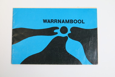 Warrnambool and District Historical Society Inc.
Booklet - Tourist booklet, Warrnambool Chamber of Commerce and Industry, Warrnambool, c. 1970
Warrnambool Tourist BookletThis is a booklet of 30 pages with a blue and black cover featuring an art work, a map, advertisements, black and white photographs and printed text. The booklet was stapled but the staples have been removed.non-fictionWarrnambool Tourist Bookletwarrnambool tourism, warrnambool tourist guides, warrnambool chamber of commerc