Showing 1176 items matching " water supply."
-
 Bendigo Historical Society Inc.
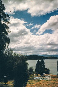
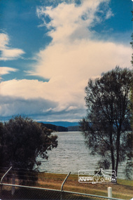
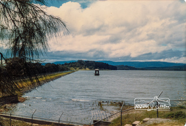
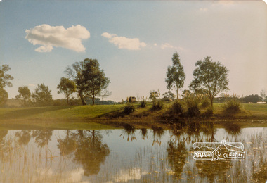
Document - Directions to Lake Eppalock with road descriptions and map
... Rivers and Water Supply Commission of Victoria. The dam wall... was built by the State Rivers and Water Supply Commission ...John Perry Collection. Laminated copy of 'Directions to Lake Eppalock'. Gives directions in relationship of Lake Eppalock to Bendigo, Kyneton and Heathcote. Undated. Gives basic descriptions of bridges on lakebed, ford crossings on lakebed and inundated dwellings on lakebed. The dam was built by the State Rivers and Water Supply Commission of Victoria. The dam wall height is 45 metres (148 ft) and the main embankment is 1,041 metres (3,415 ft) long. At 100% capacity the dam wall was designed to hold back 304,651 megalitres (6.7014×10¹⁰ imp gal; 8.0480×10¹⁰ US gal) of water. The surface area of Lake Eppalock is 3,011 hectares (7,440 acres) and the catchment area is 2,124 square kilometres (820 sq mi). The controlled spillway is capable of discharging 8,040 cubic metres per second (284,000 cu ft/s). Lake Eppalock supplies both stock and domestic water to the Campaspe irrigation district. It also serves as a water supply to Bendigo and Heathcote and, in more recent times, Ballarat. The lake is a major attraction for those engaging in watersports, with a number of tourist parks and accommodation facilities available. Permissible activities on the lake include high-speed boating, water skiing, sailing, canoeing, fishing and swimming. The lake's water levels were low for approximately eight years between 2002 and 2010 during a prolonged drought, which restricted the amount of recreational activity until rainfall in the latter half of 2010 returned the lake to 100 percent capacity. Built between 1961 and 1964, Lake Eppalock remains the only water storage on the Campaspe River system.water, dam, directions, eppalock -
 Bendigo Historical Society Inc.
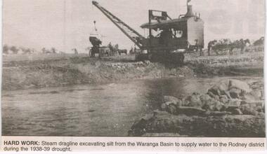
Newspaper - JENNY FOLEY COLLECTION: HARD WORK
... to supply water to the Rodney district during the 1938-39 drought... dragline excavating silt from the Waranga Basin to supply water ...Construction of the Waranga Basin initially took place 1905-1915 when it was dug by pick, shovel and horse-drawn scoops. It's embankment was initially 29ft high but over time this was increased to 40 ft. It is an off-river dam that is fed by diversion of water from the Goulbourn River and its aim is to provided irrigation water.Bendigo Advertiser ''The way we were'' from 2003. Hard work: steam dragline excavating silt from the Waranga Basin to supply water to the Rodney district during the 1938-39 drought. The clip is in a folder.newspaper, bendigo advertiser, the way we were -
 Otway Districts Historical Society
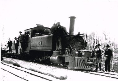
Photograph, Brucker, Beech Forest: Locomotive 5A during construction, c.1902, c.1902
... or to load ballast meant that a handy replenishment of coal and water... replenishment of coal and water supply was necessary. With earthworks ...In 1898 a recommendation for a railway of 2 ft 6 in gauge was handed down by the Parliamentary Standing Committee on Railways, to cost $138,000. Construction began in 1900. About 100 men were engaged in laying and ballasting the track while others, not included in the 100, formed the earthworks, culverts and bridges. Locomotive operations initially were two 2-6-2 Tank engines of the narrow gauge A class, dubbed "Coffee Pots", and these were used on the work trains between 1900 and 1902. Because of the lengthy periods of waiting time required to unload sleepers and rails or to load ballast meant that a handy replenishment of coal and water supply was necessary. With earthworks specified to the bare minimum landslips in the narrow cuttings were frequent so a repairer was stationed in each length to deal quickly with minor slips until 1904 when the cuttings were widened.B/W. The driver and seven other men on locomotive 5A and its flat cars at Beech Forest during construction of the line in c.1902. beech forest; railways; loco 5a; -
 8th/13th Victorian Mounted Rifles Regimental Collection
Photograph
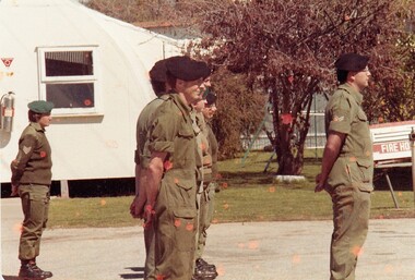
... , ammunition, ration and water supply vehicles. ..., ammunition, ration and water supply vehicles. Colour photograph ...The 8th/13th Victorian Mounted Rifles was raised as a regiment of the Royal Australian Armoured Corps on 1 May 1948 with Headquarters in Melbourne and squadrons in Sale, Benalla/Wangaratta and Albury. In 1955 Regimental Headquarters moved to Wangaratta and a second squadron was located at Albury. The Sale squadron transferred to 4th/19th Prince of Wales’s Light Horse. In 1977 8/13 VMR Regiment was reduced to an independent squadron A Squadron 8th/13th Victorian Mounted Rifles and in 1991 was linked with 4th/19th Prince of Wales’s Light Horse forming the VMR Squadron of that regiment.Members of the Women’s Royal Australian Army Corps (WRAAC) were posted to Army Reserve units in the 1980s and 1990s. They were rarely posted to Armoured Fighting Vehicles (AFVs) but were invaluable in the A1 Echelon driving fuel, ammunition, ration and water supply vehicles. Colour photograph of soldiers of ' A ' squadron 8/13 Victorian Mounted Rifles on parade at Buna Barracks Albury 1986. Sergeant D. Reynolds ( WRAAC ) at left; Corporal B. Lewis at right. -
 Wodonga & District Historical Society Inc
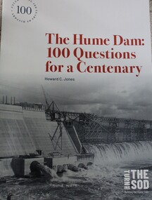
Book - The Hume Dam: 100 Questions for a Centenary, Howard C Jones, 2019
... Department of Public Works and the State Rivers and Water Supply... Department of Public Works and the State Rivers and Water Supply ...A booklet describing the history of the Hume Dam in question-and-answer format, illustrated by photographs from the Albury City Collection and other sources. This booklet was produced to accompany the exhibition "Turning the sod: building the Hume Dam", on display at Lavington Library from 21 December 2019 -1 March 2020."non-fictionA booklet describing the history of the Hume Dam in question-and-answer format, illustrated by photographs from the Albury City Collection and other sources. This booklet was produced to accompany the exhibition "Turning the sod: building the Hume Dam", on display at Lavington Library from 21 December 2019 -1 March 2020." hume dam, dams -- new south wales, hume dam history, dams -- new south wales -- design and construction -
 Eltham District Historical Society Inc
Photograph, Yan Yean, 1987, 1987
... water supply. In the early 1850’s water had been drawn from... water supply. In the early 1850’s water had been drawn from ...Originally contained in a 'magnetic' photo album of scenic photos of Yan Yean and Warrandyte believed to be donated by Mrs Eric Stephenson, Jingalong, 110 Ryans Road, Eltham, Vic. 3095; relocated to archival safe storage. On the 20th December 1853 Lieut Governor Charles LaTrobe took his spade to turn the first sod of an embankment across the swampy bed of the Plenty River at a lonely place called Yan Yean, in order to create Melbourne’s first water supply. In the early 1850’s water had been drawn from the Yarra which even then was known as Yarra Soup. A convict by the name of James Blackburn produced the basic design for supplying water to Melbourne from a reservoir on the Plenty River at Yan Yean, and later on he was appointed consulting engineer on the project. In 1853 a contract was let for the building of the wall for 91 thousand 575 pounds, and at one stage some 400 labourers were at work in the area. A tramway was constructed to convey stone and other materials from Melbourne. So famous was this magnificent stretch of water that illustrations of the bluestone embankment and tower appeared in London journals Whittlesea Historical Society – Historic items for Diamond Valley Community Radio September 1990 Colour photographyan yean, yan yean reservoir -
 Eltham District Historical Society Inc
Photograph, Yan Yean, 1987, 1987
... water supply. In the early 1850’s water had been drawn from... water supply. In the early 1850’s water had been drawn from ...Originally contained in a 'magnetic' photo album of scenic photos of Yan Yean and Warrandyte believed to be donated by Mrs Eric Stephenson, Jingalong, 110 Ryans Road, Eltham, Vic. 3095; relocated to archival safe storage. On the 20th December 1853 Lieut Governor Charles LaTrobe took his spade to turn the first sod of an embankment across the swampy bed of the Plenty River at a lonely place called Yan Yean, in order to create Melbourne’s first water supply. In the early 1850’s water had been drawn from the Yarra which even then was known as Yarra Soup. A convict by the name of James Blackburn produced the basic design for supplying water to Melbourne from a reservoir on the Plenty River at Yan Yean, and later on he was appointed consulting engineer on the project. In 1853 a contract was let for the building of the wall for 91 thousand 575 pounds, and at one stage some 400 labourers were at work in the area. A tramway was constructed to convey stone and other materials from Melbourne. So famous was this magnificent stretch of water that illustrations of the bluestone embankment and tower appeared in London journals Whittlesea Historical Society – Historic items for Diamond Valley Community Radio September 1990Colour photographyan yean, yan yean reservoir -
 Eltham District Historical Society Inc
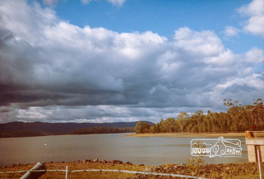
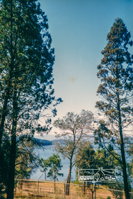
Photograph, Yan Yean Reservoir
... water supply. In the early 1850’s water had been drawn from... water supply. In the early 1850’s water had been drawn from ...Originally contained in a 'magnetic' photo album of scenic photos of Yan Yean and Warrandyte believed to be donated by Mrs Eric Stephenson, Jingalong, 110 Ryans Road, Eltham, Vic. 3095; relocated to archival safe storage. On the 20th December 1853 Lieut Governor Charles LaTrobe took his spade to turn the first sod of an embankment across the swampy bed of the Plenty River at a lonely place called Yan Yean, in order to create Melbourne’s first water supply. In the early 1850’s water had been drawn from the Yarra which even then was known as Yarra Soup. A convict by the name of James Blackburn produced the basic design for supplying water to Melbourne from a reservoir on the Plenty River at Yan Yean, and later on he was appointed consulting engineer on the project. In 1853 a contract was let for the building of the wall for 91 thousand 575 pounds, and at one stage some 400 labourers were at work in the area. A tramway was constructed to convey stone and other materials from Melbourne. So famous was this magnificent stretch of water that illustrations of the bluestone embankment and tower appeared in London journals Whittlesea Historical Society – Historic items for Diamond Valley Community Radio September 1990 Colour photographyan yean, yan yean reservoir -
 Eltham District Historical Society Inc
Photograph, Yan Yean, 1988, 1988
... water supply. In the early 1850’s water had been drawn from... water supply. In the early 1850’s water had been drawn from ...Originally contained in a 'magnetic' photo album of scenic photos of Yan Yean and Warrandyte believed to be donated by Mrs Eric Stephenson, Jingalong, 110 Ryans Road, Eltham, Vic. 3095; relocated to archival safe storage. On the 20th December 1853 Lieut Governor Charles LaTrobe took his spade to turn the first sod of an embankment across the swampy bed of the Plenty River at a lonely place called Yan Yean, in order to create Melbourne’s first water supply. In the early 1850’s water had been drawn from the Yarra which even then was known as Yarra Soup. A convict by the name of James Blackburn produced the basic design for supplying water to Melbourne from a reservoir on the Plenty River at Yan Yean, and later on he was appointed consulting engineer on the project. In 1853 a contract was let for the building of the wall for 91 thousand 575 pounds, and at one stage some 400 labourers were at work in the area. A tramway was constructed to convey stone and other materials from Melbourne. So famous was this magnificent stretch of water that illustrations of the bluestone embankment and tower appeared in London journals Whittlesea Historical Society – Historic items for Diamond Valley Community Radio September 1990 Colour photographyan yean, yan yean reservoir -
 Eltham District Historical Society Inc
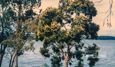
Photograph, Flowering Gum at Yan Yean, 1988, 1988
... water supply. In the early 1850’s water had been drawn from... water supply. In the early 1850’s water had been drawn from ...Originally contained in a 'magnetic' photo album of scenic photos of Yan Yean and Warrandyte believed to be donated by Mrs Eric Stephenson, Jingalong, 110 Ryans Road, Eltham, Vic. 3095; relocated to archival safe storage. On the 20th December 1853 Lieut Governor Charles LaTrobe took his spade to turn the first sod of an embankment across the swampy bed of the Plenty River at a lonely place called Yan Yean, in order to create Melbourne’s first water supply. In the early 1850’s water had been drawn from the Yarra which even then was known as Yarra Soup. A convict by the name of James Blackburn produced the basic design for supplying water to Melbourne from a reservoir on the Plenty River at Yan Yean, and later on he was appointed consulting engineer on the project. In 1853 a contract was let for the building of the wall for 91 thousand 575 pounds, and at one stage some 400 labourers were at work in the area. A tramway was constructed to convey stone and other materials from Melbourne. So famous was this magnificent stretch of water that illustrations of the bluestone embankment and tower appeared in London journals Whittlesea Historical Society – Historic items for Diamond Valley Community Radio September 1990 Colour photographyan yean -
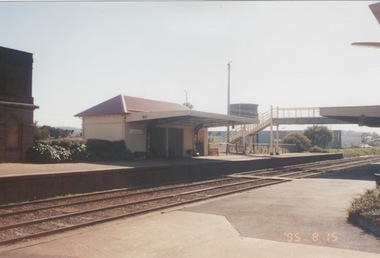 Sunbury Family History and Heritage Society Inc.
Photograph, 15th
... to supply water for the steam engines. ... of the two water towers, which in the past were used to supply water ...The Number 2 platform at Sunbury Station is featured in this image along with the former wooden pedestrian bridge and partial view of the two water towers, which in the past were used to supply water for the steam engines. A coloured photograph of a platform at a railway station which includes a pedestrian bridge and metal water tower. sunbury railway station -
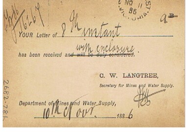 Bendigo Historical Society Inc.
Document - CONNELLY, TATCHELL, DUNLOP COLLECTION: LEGAL PAPERS, 1886
... Langtree C W, Secretary for Mines and Water Supply. 5 - 1886... card from Langtree C W, Secretary for Mines and Water Supply. 5 ...Documents. Connelly, Tatchell & Dunlop - Legal Papers. 1 - 1886 - Letter from Post Office and Telegraph Department, General Post Office, Melbourne to Messrs Bennett, Attenborough, Wilks & Connelly, Albion Chambers, Sandhurst. 2 - 1886 - Letter from Arnoldt D G, Wedderburn. 3 - 1886 - Letter from O'Reilly D, George Hotel, St Kilda. 4 - 1886 - Post card from Langtree C W, Secretary for Mines and Water Supply. 5 - 1886 - Letter from Dru?? W T, 19 Temple Court re Lazarus v Lazarus. 6 - 1886 - Letter from C ?, Raywood re Gow from Kamarooka. 7 - 1886 - Letter from Bennett, Attenborough, Wilks & Nunn, Solicitors, Melbourne to Bennett, Attenborough, Wilks & Nunn, Solicitors, Melbourne to Bennett, Attenborough, Wilks & Connelly, Solicitors, Albion Chambers, Sandhurst re Sterry v Trestrail.cottage, miners, connelly, tatchell & dunlop, post office & telegram dept, bennett attenborough wilks & connelly, arnoldt d g, o'reilly d, george hotel, langtree c w, dru?? w t, lazarus, gow, bennett attenborough wilks & nunn, sterry, trestrail -
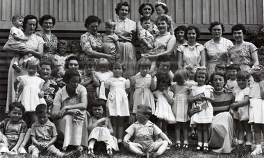 Melbourne Water
Photograph, Upper Yarra Dam Personnel, 1955
... and a safe water supply system. In 1992, The MMBW merged... and a safe water supply system. In 1992, The MMBW merged ...As the Yarra became unsuitable as a source of water, several attempts were made to find alternative sources for the growing population of Melbourne. It was not until 1891 that the efforts to sewer Melbourne came to fruition with the setting up of the Melbourne Metropolitan Board of Works (MMBW), now known as Melbourne Water. From 1891 until 1992, it was the responsibility of the MMBW to safeguard public health by providing a sewerage system and a safe water supply system. In 1992, The MMBW merged with a number of smaller urban water authorities to form Melbourne Water. In 1946, the Melbourne and Metropolitan Board of Works (MMBW) approved a site for a new dam for Melbourne's domestic water. This is now known as the Upper Yarra Dam. Due to the construction of the dam, the workforce had to be accommodated on site; domestic quarters were built for single men, families and staff. The township also had kitchens, laundry facilities, a canteen, a recreation hall, mess areas and a co-op store, with one of the first houses being seconded to accommodate for a school. This photograph shows personnel at a Kindergarten party at the Upper Yarra Dam, a time where workers were housed during its construction. The photograph is historically significant as it captures a purpose built community that supported the workers undertaking the construction of the dam. upper yarra dam, mmbw, melbourne metropolitan board of works, township, 1940s, community -
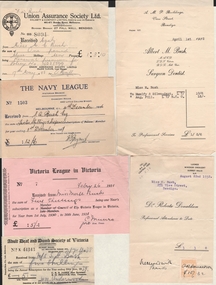 Bendigo Historical Society Inc.
Document - BUSH COLLECTION: ASSORTED INVOICES/RECEIPTS RE BUSH FAMILY, 1926-1939
... and Water Supply Commission, City of Bendigo, Bendigo Sewerage..., Chaucher Library and Book Shop, State Rivers and Water Supply ...Assorted invoices/receipts re Bush family. Bendigo and Melbourne business for Mr S Bush & Miss Merle Bush. Receipts from businesses, charities and municipal sources. Adult deaf and Dumb Society of Victoria, Union Assurance Society, British and Foreign Bible Society, Victoria League in Victoria, The Church Missionary Society, The Navy League, Victorian Railways Commissioners, The Girl Guides' Association, Robert Batchelor dentist, Albert M. Bush, Foy and Gibson Pty Ltd, Hartley's, T.S. Glasier & Co, W.H. Osborn Pty Ltd, The Northern Seed Supply, Myer Emporium, William Lunn, Allan & Co, Chaucher Library and Book Shop, State Rivers and Water Supply Commission, City of Bendigo, Bendigo Sewerage Authority, Bendigo Gas Company, Bendigo Electricity Supply and Tramways, Bendigo Electricity Supply, Howard Pty Ltd, R. O. Henderson, Vacuette Company, Sands McDougall Pty Ltd, Colonial Gas Association, Stilwell's, Provincial Motors Pty Ltd.person, family, bush collection (family -
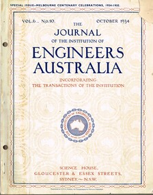 Melbourne Tram Museum
Magazine, Engineers Australia, Journal of the Institution of Engineers Australia" - Vol 6, No. 10, Oct. 1934, "Metropolitan and Provincial Tramways", Oct. 1934
... of Melbourne, Outer ports, air transport, water supply, sewerage... transport, water supply, sewerage and drainage, gas industry ...Journal or magazine - stapled pages approx. 100 printed on semi gloss paper, with glue outside cover, titled Journal of the Institution of Engineers Australia" - Vol 6, No. 10, Oct. 1934 - Special issue - Melbourne Centenary Celebrations 1934 - 1935. Contains transactions of radio frequency, institution and related activities, and 100 years of Engineering in Victoria. These include maps of Victoria and Melbourne, Engineering Education (Kernot), Metropolitan Roads and Bridges by J. Noble Anderson City Engineer of Richmond, Country Roads and Bridges, Railway Development (VR), Metropolitan and Provincial Tramways (Strickland and Russell), Port of Melbourne, Outer ports, air transport, water supply, sewerage and drainage, gas industry, electricity supply, communications (telephone and telegraph), industrial development and mining. Has ads for British Insulated cables, Thompsons Engineer, Goodyear, GEC - British General Electric, Associated General electric, Vickers and many other companies. Photocopy of article from the Bob Lilburn collection.trams, tramways, centenary, victoria, tramways, railways, secv, mmtb, cable trams -
 The Beechworth Burke Museum
Photograph, Unknown c.1930s
... . The State Rivers and Water Supply Commission of Victoria and the New.... The State Rivers and Water Supply Commission of Victoria and the New ...This image shows Bethanga Bridge, which was constructed between 1927 and 1930 in Albury, NSW. The bridge was a necessity due to the building of the Hume Dam (Wier), 1919-1936. Bethanga Bridge is a long, nine-span, riveted-steel, variable depth, Pratt Truss road bridge of nine principal spans of 82 metres and a total length of 752 metres over the flooded valley of the Murray River, now part of Hume Reservoir. Because of its unique location, over the waters of a dam with the border running down the centre of the body of water, the Bethanga bridge is the only built structure shared by both New South Wales and Victoria. It was built 1.6 kilometres upstream of the dam and in 1961 was raised 300mm, with a concrete deck replacing the original wooden deck. The State Rivers and Water Supply Commission of Victoria and the New South Wales Department of Public Works were responsible for the construction works for the Hume Weir under the River Murray Waters Agreement. It is apparent that a similar joint arrangement was made for the construction of the Bethanga Bridge as part of the Hume Weir works.This photograph of the Bethanga Bridge is of historical significance as it showcases the architectural skills of Percy Allen and Vincent Packer. Additionally, it reveals the environmental landscape of the 1920s-1930s, is linked to the Hume Dam and both New South Wales and Victorian heritage. Unmounted black and white rectangular photograph. Reverse: 1997.3196 84-20-3bethanga, bethanga bridge, hume dam, pratt truss, murray river, hume weir, transportation -
 Eltham District Historical Society Inc
Photograph, Liz Pidgeon, Heritage Excursion; East of Eltham, 6 Sep 2014, 20 May 2017
... but leaving significant areas as power line and water supply reserves... but leaving significant areas as power line and water supply reserves ...Newsletter No. 218, September 2014 September Excursion - East of Eltham Walk In Newsletter No. 197, March 2011, there was a brief history of Crown Allotment 15 Section 5 Parish of Nillumbik (CA 15) a parcel of land of a quarter of a square mile extending from Eucalyptus Road to Reynolds Road at the eastern extremity of Eltham. From the 1940s it was known as Stokes orchard. In later years it has been subdivided for residential purposes but leaving significant areas as power line and water supply reserves and bushland reserves that are habitat for the threatened For our excursion on 6th September we intend to walk through CA 15 to a bushland reserve east of Reynolds Road. The walk will traverse the boundary between suburban Eltham and the non-urban areas to the south and east. This is a pleasant walk through residential areas and bushland. Along the way we will discuss the early and more recent history of CA 15 as well as local natural history and geology. This walk is about 3.5 km in length and will take 2 to 2.5 hours. It will start at 2pm at the corner of Eucalyptus Road, Pitt Street and Nyora Road.Born Digitaleltham east, eltham district historical society, heritage excursion, activities, nyora road, reynolds road, gum tree road reserve, diosma road, stokes orchard, eucalyptus road -
 Eltham District Historical Society Inc
Photograph, Liz Pidgeon, Heritage Excursion; East of Eltham, 6 Sep 2014, 20 May 2017
... but leaving significant areas as power line and water supply reserves... but leaving significant areas as power line and water supply reserves ...Newsletter No. 218, September 2014 September Excursion - East of Eltham Walk In Newsletter No. 197, March 2011, there was a brief history of Crown Allotment 15 Section 5 Parish of Nillumbik (CA 15) a parcel of land of a quarter of a square mile extending from Eucalyptus Road to Reynolds Road at the eastern extremity of Eltham. From the 1940s it was known as Stokes orchard. In later years it has been subdivided for residential purposes but leaving significant areas as power line and water supply reserves and bushland reserves that are habitat for the threatened For our excursion on 6th September we intend to walk through CA 15 to a bushland reserve east of Reynolds Road. The walk will traverse the boundary between suburban Eltham and the non-urban areas to the south and east. This is a pleasant walk through residential areas and bushland. Along the way we will discuss the early and more recent history of CA 15 as well as local natural history and geology. This walk is about 3.5 km in length and will take 2 to 2.5 hours. It will start at 2pm at the corner of Eucalyptus Road, Pitt Street and Nyora Road.Born Digitaleltham east, eltham district historical society, heritage excursion, activities, nyora road, reynolds road, gum tree road reserve, diosma road, stokes orchard, eucalyptus road