Showing 5282 items
matching flood-marker-orbost
-
 Orbost & District Historical Society
plan, before 1948
Drainage infrastructure was developed and maintained in this region by the Snowy River Improvement Trust. The Trust was administered by a local committee and its activities funded by a local rate charged on the farmers and land owners in the Trust’s designated district. The level of the rate charged by the Trust was designed to be proportionate to the benefit derived from the works undertaken. Financial assistance was provided by the State Government from time to time for specific projects such as post flood repairs but not for new capital works. The Trust undertook new drainage and river management works including tree planting, rock beach construction and servicing of the drains and flood gates. The Trust also provided a personal flood warning service to the farmers in its district. The Trust ceased to operate in 1997 with the advent of the East Gippsland Catchment Management Authority. The infrastructure developed by the Trust continues to provide a service to the farmers in the region. (ref. 4 East Gippsland CMA Submission to Inquiry into Flood Mitigation Infrastructure in Victoria) This plan is significant as a historical document. The Snowy River Improvement Trust was vital to the Orbost district because of its ability to apply local knowledge and to engage the local farming community.A large plan of divisions of land for the purpose of levying the Snowy River Improvement District - Bete Bolong, Orbost, Waygara, Newmerella and Orbost East. The properties are coloured according to levy amount. The scale is 1" - 20 chains. snowy-river-improvement-trust -
 Orbost & District Historical Society
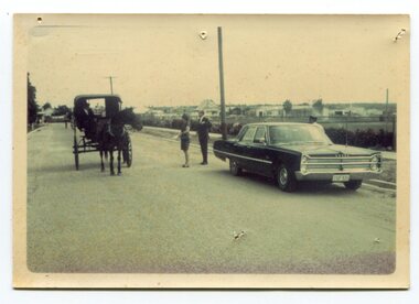
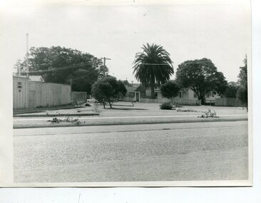
Photograph - Opening of Orbost Museum
This is a photograph of Mr & Mrs Peter Nixon about to board Kaye Lynn's covered jinker which is pulled by a horse to travel to open the Orbost Historical Society's Museum in Nicholson Street, Orbost. The original location of the Museum 1967 was in the building which is now (2022) used by the Cricket Club & Senior Citizens. The Library was also located there. Since 1994 and following the Orbost Shire's amalgamation into East Gippsland, the Library and Museum were located into the Shire's Business Centre in Ruskin Street, Orbost.photograph of an event in Orbost A b/w photograph of large car on the right hand side, two people in the centre, and a horse and sulky on the left. They are in a street.On back: Mr and Mrs Nixon are about to board Kaye Lynn's covered jinker to travel to open Orbost Historical Museum in Nicholson Street, Orbost. peter nixon mp, orbost museum, kaye lynn -
 Orbost & District Historical Society
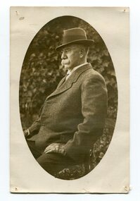
black and white photograph, early 20th century
This is a portrait of Dr James Kerr. Dr James Kerr practised medicine in Orbost from 1889 -1928. He was the first doctor to settle in Orbost. He served the Orbost community for 40 years travelling everywhere on horseback. He married Hilda Constance Temple in Orbost on November 30, 1893. On April 29th 1931, three glass windows were dedicated to "Dr James Kerr. Beloved Physician of Orbost" in St James Church of England , Orbost. ( Ref Orbost Hospital, History, Personalities and Stories by Margaret Hollands) Dr James Kerr was the first doctor to settle in Orbost. He was an integral part of the Orbost community for over 40 years.A black / white photograph of a man with glasses wearing a suit, hat and gloves, sitting on a chair, with one hand resting on his thigh. He has a bushy moustache. The portrait is oval shaped with a white background. kerr-james orbost-hospital medical-doctor -
 Orbost & District Historical Society
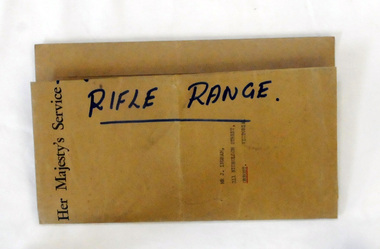
documents, 26 January 1964
These documents were sent to Mr J. Ingram, 211 Nicholson Street, Orbost, Victoria from the Australian Rifle Club.A brown envelope containing two copies of a plan of the Orbost Rifle Range. There is also a memorandum of Agreement concerning the Orbost North Recreation Reserve. There is a letter from the Victorian Rifle association concerning the extension of the rifle range.orbost-rifle-club shooting rifle-range-orbost -
 Orbost & District Historical Society
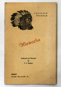
booklet, Hiawatha, 1949
This is a souvenir program made for the musical event, Hiawatha, presented by Orbost Rotary Club on November 28,29 1949. Miss Elsie Lambert was a teacher at Orbost State School for 25 year.This is representative of the entertainment popular in Orbost in the 1940's-1950's.Two small 12 pp cream coloured books with brown print and the head of an American Indian chief in head-dress on the cover. It is titled"Hiawatha" prod. and directed by F.C. Herbert. a musical event presented in Orbost 1949, performed and sponsored by the Orbost Rotary Club. This was a souvenir program.On the back cover 657.1 in ink - E. Lambert.souvenir-program hiawatha musical orbost-rotary -
 Kew Historical Society Inc
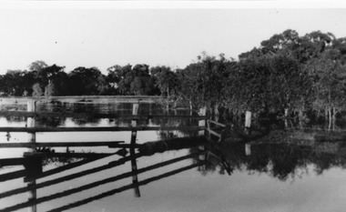
Collection, Floods in North Kew (Series), 1929–1934
Flooding of the Yarra Valley, including that section of the Yarra bordering Kew and Kew East in the north and west of the municipality, was a regular occurrence. Extreme flood events of the Yarra River are recorded to have occurred in 1891, 1901, 1916, 1923 and 1934. The Municipality of Kew's response to these floods was to enact planning decisions restricting residential development in flood prone areas following the floods of 1916, 1921 and 1934. While floods continued after the development of the Upper Yarra Reservoir (construction 1948-57), the regularity and extent of these inundations diminished. Natural disasters had an impact on the development and settlement of Melbourne and its suburbs. Flooding in the Melbourne region was a regular event in the nineteenth and for most of the twentieth centuries. Changes in the impact of natural disasters could occur due to a number of factors. This collection of small snapshots, mostly taken from Kellett Grove in North Kew, provide provenanced evidence of flooding in the area before the development of the unnatural flood barrier that is the Eastern Freeway.Collection of 16 monochrome photographs, annotated on verso by different hands, of the flooding of the River Yarra in North Kew in the third and fourth decades of the twentieth century [1920s & 1930s]. Individual photos include the dates of different floods. Many of the photos were taken from the rear of 8 Kellett Grove; a house still extant in 2023yarra river -- north kew, floods -- yarra valley, floods -- north kew, floods -- 1929, floods -- 1934, natural disasters -- kew -
 Orbost & District Historical Society
black and white photographs, C 1970s
3287.1 has been taken in front of the Orbost Swimming Pool. 3287.2 has been taken in Wolseley Street, Orbost and 3287.3 was photographed in Boundart Road, Orbost,These photographs are pictorial records of incidents occurring in Orbost C1970s.Three black / white photographs of tree damage in town streets. 3287.1 shows trees which been vandalised, 3287.2 and 3287 3 are photographs of storm trees which have been damaged. -
 Orbost & District Historical Society
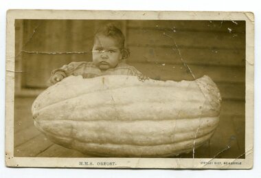
photograph / postcard, first half 20th century
The child in the photograph is Delia Murray (Mrs Jack Kenny). She was one of eight children of Herbert Cecil Murray and Evelyn Murray. Photographs of children families sitting in hollowed out pumpkins were common in the first half of the 20th century. This item is associated with a popular activity of the Orbost community in the first half of the 20th century. Pumpkins have been been paat of the district's agricultural history since settlement.A black / white photograph / postcardof a small girl sitting in a hollowed out pumpkin. It appears to have been taken outside on a verandah of a wooden house.on front - " H. M. S. Orbost" ; "Stanley Vogt, Bairnsdale" on back is a letter - "I got the plants......."pumpkins-orbost murray-delia -
 Hume City Civic Collection
Photograph, 14/08/1909
The Jackson Creek flooded on 14 August 1909 when the creek was 32 feet above sea level.A sepia photograph of the Jackson Creek in flood. Goonawarra winery is in the background. Unmounted postcardjackson's creek, goonawarra farm, sunbury, floods, gregor, bob, billinghurst, beryl, francey, sandra, alex, bridges, macedon street bridge, george evans collection -
 Orbost & District Historical Society
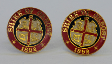
cuff links, 1992
This pair of cuff links was produced in 1992 as a memento/souvenir to commemorate the centenary of the formation of the Shire of Orbost - 1892-1992. Orbost was at first included in the Bairnsdale Shire from 1882 and was later part of the Tambo Shire. Because of travelling distances the Croajingalong Shire was created in 1892 (name changed to Orbost Shire 17.2.1893 with James Cameron as the first Shire President. In 1994 it amalgamated to become part of East Gippsland Shire Council.A pair of gold-plated and enamel cuff links embossed with the Shire of Orbost Coat of Arms and the year of inauguration.Shire of August 1892cuff-links souvenir memento orbost-shire-council -
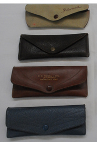 Orbost & District Historical Society
glasses' cases, c. 1950s - 1980s
Four spectacle cases used in the Orbost district, one being owned by S McKeown and supplied by R C Mansell who was a consulting optometrist in Orbost.Four spectacle cases catalogued 817.1 to 817.4. They are of a similar shape but have different colourings. 817.2 has the words S McKeown, Orbost written inside indicating the owner and R C Mansell L O Sc Optometrist, Orbost on the outside indicating the supplier. 817.4 has the word Polaroid on the outside.spectacle-case mansell-optometrist -
 Kew Historical Society Inc
Photograph - Yarra in Flood, 1934
Flooding of the Yarra Valley, including that section of the Yarra bordering Kew and Kew East in the north and west of the municipality, was a regular occurrence. Extreme flood events of the Yarra River are recorded to have occurred in 1891, 1901, 1916, 1923 and 1934. The Municipality of Kew's response to these floods was to enact planning decisions restricting residential development in flood prone areas following the floods of 1916, 1921 and 1934. While floods continued after the development of the Upper Yarra Reservoir (construction 1948-57), the regularity and extent of these inundations diminished.Black and white print positive. 1934 floods of the Yarra Valley. Location Fairfield looking towards wooded hillside. Houses floating in river.Reverse: "From Fairfield Park (11936?) back towards hill (Wurundjeri Spur?)"floods -- 1934, yarra valley, yarra river, fairfield park -
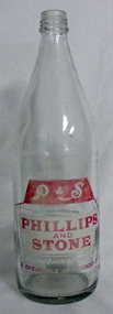 Orbost & District Historical Society
bottle, C 1970's -1990's
Dross Drossou sold his cordial manufacturing business to Phillips and Stone, a Bairnsdale company, in 1948. Phillips & Stone continued to manufacture soft drinks at Orbost until the early 1970s when the factory became a distribution centre. It closed as a distribution centre in 1978 and later served as the headquarters of the Orbost State Emergency Service. The site of the Cordial Factory now forms part of the carpark at the rear of the Orbost Newsagency. (John Phillips) This bottle is an example of a product manufactured/distributed by a local industry no longer existing.A narrow-shouldered, clear glass bottle with white and red lettering. The neck is threaded (cap is missing). It is labelled "P & S 850ml; Phillips and stone; refreshing drinks. BAIRNSDALE AND ORBOST. Manufactured by Phillips & Stone Bairnsdale & Orbost E2361. Preservative added. Artificially coloured and flavoured."glass-bottle container phillips-and-stone -
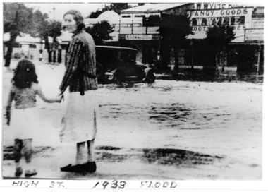 Charlton Golden Grains Museum Inc
Photograph, c.1923
1933 flood at War Memorial corner of Mrs Barber and daughter Unframed B/W Photograph of 1933 flood at War Memorial corner of Mrs Barber and daughter flood, charlton, charlton war memorial -
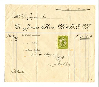 Orbost & District Historical Society
account, February 1911
Dr James Kerr practised medicine in Orbost from 1889 -1928. He was the first doctor to settle in Orbost. He served the Orbost community for 40 years travelling everywhere on horseback. He married Hilda Constance Temple in Orbost on November 30, 1893. On April 29th 1931, three glass windows were dedicated to "Dr James Kerr. Beloved Physician of Orbost" in St James Church of England , Orbost. ( Ref Orbost Hospital, History, Personalities and Stories by Margaret Hollands) Robert Pullar Cameron was a Shire Councillor for many years. He married Penuel Hossack and had a family of James, Flora, Penuel and Alex. Dr James Kerr was the first doctor to settle in Orbost. He was an integral part of the Orbost community for over 40 years. Robert Pullar Cameron was a councillor on the Orbost Shire Council for many years.A white paper account with black print. It has a green duty stamp on the front and is from Dr James Kerr M.B.C.M. to R. Cameron. The form has been filled in by hand.kerr-dr-james cameron-r.p. -
 Orbost & District Historical Society
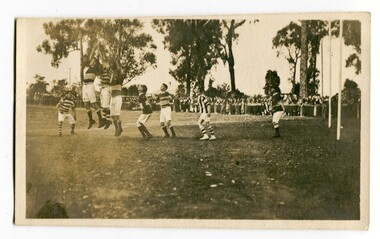
black and white photograph, Wilson, Len G, 1920s
The Orbost football club players were known as the Busters and wore green and gold guernseys. An Orbost football team has participated in the East Gippsland League since the early 20th century. In 2003 in response to a dwindling population, the Snowy Rovers and Orbost Football Clubs were driven to merge into the Orbost Snowy Rovers Football clubs, through their many changes, have always been an important social fabric of the community. Sport is often regarded as an important part of life in rural Australia, contributing to community identity, sense of place, social interaction and good health.A black / white photograph of men playing football. Three men are jumping for the ball. The goal posts are on the right side. A large group of spectators are at the rear behind a fence.recreation sport-football orbost-football-club -
Ballarat Heritage Services
Film - Flooding at Hepburn Mineral Springs Reserve October 7 2022, Lisa Gervasoni, Video of flooding on Wild Cat Creek, 07/10/2022
Wild Car Creek usually gently flows through Hepburn Springs Reserve. After a rainstorm on 05 October the creek flooded, covering the mineral water springs at Hepburn Springs Reserve.Flooding at Wild Car Creek at Hepburn Mineral Springs Reserve flooding at hepburn mineral springs reserve, hepburn springs reserve., mineral water, wild cat creek, locarno mineral water spring -
 Kew Historical Society Inc
Photograph - Flooding of the Yarra Valley at Kew, 1974
Flooding of the Yarra Valley, including that section of the Yarra bordering Kew and Kew East in the north and west of the municipality, was a regular occurrence. Extreme flood events of the Yarra River are recorded to have occurred in 1891, 1901, 1916, 1923 and 1934. The Municipality of Kew's response to these floods was to enact planning decisions restricting residential development in flood prone areas following the floods of 1916, 1921 and 1934. While floods continued after the development of the Upper Yarra Reservoir (construction 1948-57), the regularity and extent of these inundations diminished. During the nineteenth century, the land abutting the south side of the Yarra in Kew was devoted to dairy farming. In the twentieth century, before and after the construction of the Eastern Freeway, much of this low-lying area was used as golf courses and public parks.Late example of the capacity of the Yarra Valley at Kew to flood, even though drainage works and the Upper Yarra Reservoir had reduced their regularity.Original black and white print photograph of the low-lying land at East Kew under floodwater on 16 May 1974. The photograph is taken from 43 Kellett Grove.Annotation verso: "Kellett Gve No.43 / Flood Level / 16 May 1974 11.40am"floods, yarra river, kellett grove -
 Charlton Golden Grains Museum Inc
Photograph, B/W photograph of Flooded Billabong Cadrows Dairy in the bend of the Avoca River
Flooded Billabong Cadrows Dairy in the bend of the Avoca River, Charlton, VictoriaB/W photograph of Flooded Billabong Cadrows Dairy in the bend of the Avoca River, Charlton, Victoriaflood, charlton, avoca river, cadgow -
 Orbost & District Historical Society
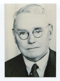
black and white photograph, C1945
This is a photograph of Councillor William Godfrey Robinson who represented East Riding in the Orbost Shire Council 1938 - 1947. William Godfrey Robinson was a Charter member of the Orbost Rotary Club and was the secretary of Orbost agricultural society in 1931.This item is associated with the Orbost Shire Council. The shire covered an area of 9,347 square kilometres and existed from 1892 until 1994 when it became part of the East Gippsland Shire Council.A black / white head and shoulders portrait photograph of a bespectacled man in a suit.on back - " Cr William Godfrey Robinson 1944-1945"orbost-shire-council robinson-william-godfrey -
Tatura Irrigation & Wartime Camps Museum
Photograph - copy, 1955 flooding Tatura, 1955
Copy of photograph of Eric Welch's Newsagency, part of Cussen House and saddlers store during flooding of Hogan Street Tatura 1955. Black and white photograph of shops in Hogan Street, Tatura, during 1955 floodingEric Welch's Newsagency February 1955eric welch newsagency, flooding hogan street tatura 1955, cussen house -
 Orbost & District Historical Society
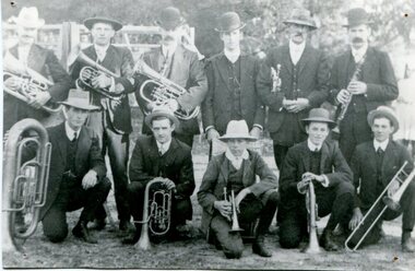
black and white photograph, 1907
The Orbost Workers' Band and the Orbost Town Band amalgamated in 1913 to form the Orbost Municipal Band under the conductorship of Mr Charles Spink. This photo, taken in 1907, is probably of the orbost Town Band. In the photo are : Percy Watt, Geoff Beattie, Bill Gluth, Charles Spink, Bert McCay, R. Cotterill, Fred Smooker, George Draffin and Jin Lynn. The various Orbost bands have played a major role in the Orbost community activities as well as providing entertainment and musical experiences for the many members. A black and white photograph of two rows of men,front row kneeling and back row standing. The men are dressed in suits with waistcoats and are wearing hats.Each is holding a brass instrument. -
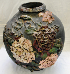 Orbost & District Historical Society
ginger jar, Pre 1893 floods in Orbost
In the early days of Orbost many Chinese were engaged in land clearing or had arrived when gold was discovered in East Gippsland in the 1840's. They lived in camps along the Marlo Road and houses were usually built on stilts. They left after the 1893 floods.This object has aesthetic appeal. It is an object which belonged to the very early settlement days of Orbost.Huge, ornate Chinese ginger jar. Four raised hand- painted pink roses on front. Jar itself is matt black. Looks more like a vase than a ginger jar. Ceramic.Some Chinese writing to left hand side of roses.ceramics, ginger jar, container - domestic, vase -
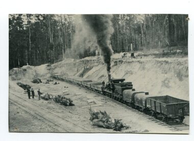 Orbost & District Historical Society
black and white photograph, late 19th / early 20th century
This is a photograph of the gravel pit at Newmerella, near Orbost. This pit was used during the construction of the Orbost to Bairnsdale Railway line.This item is associated with the history of the Orbost-Bairnsdale railway line and therefore reflects the role that the rail line played in the social and economic history of Orbost. The Bairnsdale-Orbost railway was opened in 1916 to serve the agricultural and timber industry. Because of the decline in traffic and heavy operating costs, the line was finally closed in August, 1987. A black / white photograph of a small steam engine with open freight wagons at a gravel pit. There are some men watching. -
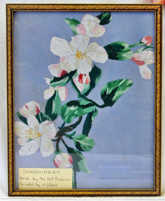 Orbost & District Historical Society
Embroidery, Anderson, Dot (Mrs)
Donor, Mary Gilbert lived in Orbost 1905-1989 and was teacher/headmistress at Orbost High School 1927-1968. A local historian, she collected stories from local families, compiling the book "Personalities & Stories of the Early Orbost District"This item is of aesthetic significance and is an example of the skill and craftmanship of women in early times.A colourful embroidery of flowers, in bloom and bud. Leaves are variegated.Worked on a blue background and framed in a gold-coloured wooden frame. Frame has tiny raised leaves along sides. -
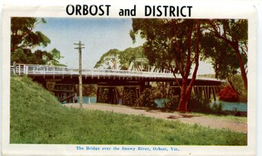 Orbost & District Historical Society
postcard series, 1960s
Included are photographs of the Orbost township, the Snowy River at Marlo, Gypsy Point, Buchan Caves and Bairnsdale. In the 1960s Orbost had a population of 4000 and was a major tourist attraction in Eastern Victoria with sufficient accommodation and facilities. It was the major town close to several national parks with access to either the surf or the snow. These postcards are pictorial records of Orbost in the 1960s. Postcards are very interesting records of places. architecture and transport.A colour postcard series with photographs of Orbost and the district. The cover photograph is of the Snowy River Bridge. There is an information card.Each photograph is labelled. at the bottom.postcards-orbost postcards-east-gippsland -
 Orbost & District Historical Society
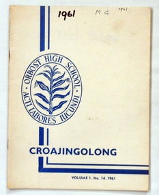
magazines, Croajingolong 1961, 1961
This is the fourteenth issue of the Orbost High School annual magazine. The name Croajingolong derives from the Australian Aboriginal Krauatungalung words galung, meaning "belonging to" and kraua, meaning "east". 2209.1 belonged to Mary Gilbert, a former teacher at the school. 2209.3 belonged to Brenda Murray, a former mayor of East Gippsland Shire Council and prominent Orbost identity.This is the fourteenth issue of the Orbost High School magazine and is a useful reference tool.Three copies of a cream coloured magazine Croajongolong in dark blue print Vol. 1 No.14 1961.In the centre is the Orbost High School crest of a sheaf of corn inside a double oval with Orbost High School and its motto " acti labores iucundi"croajingolong orbost-high-school -
 Orbost & District Historical Society
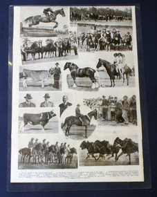
photographs, mid 20th century
Samuel Lynn (1865-1949) was a farmer and grazier at Jarrahmond. He bred Clydesdales. The 13th Light Horse Regiment was formed at Broadmeadows in Victoria in March 1915; it was the third light horse regiment to have been raised in that state. Its regimental number quickly led to it becoming known as the "Devil's Own" regiment. It left Australia on 28 May and disembarked in Egypt on 29 June 1915. Horses have always been an important part of Orbost's history.A laminated set of photographs on cardboard. it is an arrangement of black / white photocopies posibly for a magazine or display. The photos are of local horses, local people and include Mr S. Lynn, A. Mosely and Orbost No 2 troop 13th Light Horse.photographs-horses lynn-samuel mosely 13th-light-horse -
 Orbost & District Historical Society
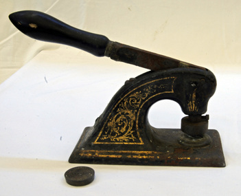
embosser and seal, 1890's
This stamp and seal were collected by Kevin Ingram who cleaned up the Orbost Butter factory in 1981. It is possibly from the original factory in the 1890's.This seal was probably used on official letters.The Orbost Butter and Produce Co. Ltd was registered on June 1st 1893 and was an important source of income to the Orbost district.Cast iron stamp and seal. Stamp (.1) has a wooden handle which works by a lever action. It has a rectangular base plate and is painted black.The main stem is decorated in gold paint. The separate seal (.2) seems to have been attached to the stamp.On seal in centre : ORBOST Around edge of seal : Orbost Butter Factory plus some unreadable print orbost-butter-factory agriculture farming seal embosser stamp -
 Kew Historical Society Inc
Photograph, Floods in North Kew, 1934
Living with natural processes was frequently a challenge to early European settlers and later residents of what was in the 1850s administered by the Borondara Road Board. This was compounded by the area being bounded on three sides by rivers (Yarra River, Koonung Creek and Gardiner's Creek). In 1849, the historian James Bonwick recorded that "our district [Kew] suffered considerably. Mr Wade speaks of 80 acres, out of 100 acres of his cultivated paddock, covered by water." Newspapers continued to describe major flooding in Kew in 1863, 1869, 1878, 1880, 1889, 1891, 1916 and 1934. While the construction of the Upper Yarra dam in 1957 reduced the levels of flowing downstream, local and riverine floods continue.The Kew Historical Society's pictures and map collections testify to the impact of flooding in the district. They have historical importance in documenting the extent of flooding in the district and its affects on homes, services and recreation. Numerous photographs record flooding throughout the Twentieth Century.Floods in North Kew, 1934. Vicinity of Willsmere Park.floods (kew)