Showing 1695 items
matching grover
-
 Kew Historical Society Inc
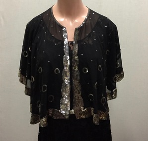
Clothing - Lace and Sequins Evening Capelet, 1930s
Doris Mercy Willmott was born in May 1896 in Stamford Hill, London, the eldest of three daughters of Albert and Minnie Willmott. The family lived in various parts of north London until the beginning of the First World War, when they moved to Redhill in Surrey. It was in Redhill that Doris met her future husband, Frederick John (Jack) Bennett. Although Jack Bennett returned to Melbourne in March 1919, he and Doris continued to correspond and they were engaged in March 1923. She came to Melbourne on her own, and was married in the Congregational Church in Canterbury on 23 December 1923. In 1937, the Bennett family moved back to the United Kingdom, spending the war years in Uxbridge and Torquay. The family returned to Melbourne in October 1946, after the deaths of Doris’ parents. The family lived at 12 Stanhope Grove, Camberwell and 51 The Ridge, Canterbury before Jack died in February 1952. After this Doris moved to 12 Stanley Grove, Canterbury, her home until c. 1970 when she moved to 25 Corhampton Road, North Balwyn. She died in May 1980 in Princeton Nursing Home, 3 Bellett Street, Camberwell. (Adapted from notes provided by Sue Barnett, the donor).The collection of evening clothes owned and worn by Doris Mercy Bennett, of which this item is one, date from the 1930s and may have been purchased in Australia or in the United Kingdom. Each of the items, apart from the evening dress, which has a few minor tears in the lace, is of fine quality and evidences Doris Bennett’s love of glamour and style. While the evening dress and the mantilla are of the same fabric, the two capes might have been worn with the dress as alternative fashion accessories. None of the items has a maker’s mark, however each displays evidence of fine dressmaking skills. It is however probable that the two fitted capes were commercially made.Black silk chiffon or georgette loose-fitted evening capelet, decorated with a wide border of silvred sequins. Sequins are also used in the body of the cape, either individually or in circles. The capelet was owned and worn by Doris Mercy Bennett (nee Willmott) [1896-1980], and donated to the Society by her granddaughter. women's clothing, evening wear, evening dresses, capes, susan barnett, doris bennett (nee wilmott) -
![Scene in the Melbourne Botanical Gardens / [by] Nicholas Caire, circa 1876](/media/collectors/550653872162f11fb04854aa/items/577b5a2dd0cdd10948d09d9a/item-media/577b5a96d0cdd10948d0d84a/item-fit-380x285.jpg) Kew Historical Society Inc
Kew Historical Society IncPhotograph, Anglo-Australasian Photographic Company, Scene in the Melbourne Botanical Gardens, c. 1876
Nicholas Caire was born on Guernsey in the Channel Islands in 1837. He arrived in Adelaide with his parents in about 1860. In 1867, following photographic journeys in Gippsland, he opened a studio in Adelaide. From 1870 to 1876 he lived and worked in Talbot in Central Victoria. In 1876 he purchased T. F. Chuck's studios in the Royal Arcade Melbourne. In 1885, following the introduction of dry plate photography, he began a series of landscape series, which were commercially successful. As a photographer, he travelled extensively through Victoria, photographing places few of his contemporaries had previously seen. He died in 1918. Reference: Jack Cato, 'Caire, Nicholas John (1837–1918)', Australian Dictionary of Biography.An original, rare photograph from the series 'Views of Victoria: General Series' by the photographer, Nicholas Caire (1837-1918). The series of 60 photographs that comprise the series was issued c. 1876 and reinforced a neo-Romantic view of the Australian landscape to which a growing nationalist movement would respond. Nicholas Caire was active as a photographer in Australia from 1858 until his death in 1918. His vision of the Australian bush and pioneer life had a counterpart in the works of Henry Lawson and other nationalist poets, authors and painters.Views of Victoria (General Series) No.30 / ‘Scene in the Melbourne Botanical Gardens’ / Albumen silver photograph mounted on boardOn Reverse: ‘The Scene of the present illustration is taken from the Hill on the South Yarra side of the Gardens, shewing in the distance the Government Domain. In the centre of the picture a portion of the Lake may be seen. This Lake is of considerable extent, and being surrounded by hills, the slopes of which contain many beautiful Fern Groves and Vistas of the densest foliage, adds greatly to the beauty and picturesqueness of the surrounding scenery.’nicholas caire (1837-1918), australia - landscape photography -
 Ringwood and District Historical Society
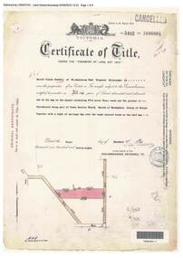
Document, Certificate of Title - Harold Claude Howship, Nurseryman, Ringwood, Vic. - 1928
A4 copies of Landata Victoria Historical Search documents - Vol 5485 Fol 1096804. Harold Claude Howship of Mt. Dandenong Road Ringwood, Nurseryman, is now the proprietor of an Estate in Fee-simple subject to the Encumbrances notified hereunder ... 5 acres 3 roods 10 perches or thereabouts, part of Crown Section Twenty, Parish of Warrandyte, County of Evelyn, together with a right of carriage way over roads coloured brown. Subdivision map includes Wonga Road (later Warranwood Road), Grandview Grove (later Bemboka Road), and Plymouth Road, Ringwood. Proprietors and Transfers include Emily Mills, Plymouth Road Ringwood, Widow - 27th January, 1939. William George Carter, Grandview Grove Warranwod - 14th March, 1947 - 3 acres Evelyn Goudie and Beverley Gwen Goudie, Wonga Road Warranwood - 23rd October, 1950 - 1 acre -
 Orbost & District Historical Society
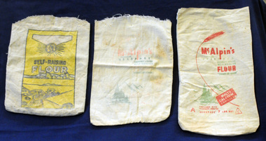
flour bags, mid 20th century
These three flour bags belonged to Helena Warren (nee McKeown) who was a self-taught photographer who became the local press correspondent and producer of postcard images. She was married to William John warren and lived in Newmerella. Flour bags were used for bulk purchases of flour in early to mid 20th century. They would have been laundered and re-used for storage. In earlier times empty flour bags were washed and boiled and then made into tea towels or children’s bloomers, or underwear. The flour bags are good examples of packaging and design for Australian produce which sold across Australia and overseas in the mid 20th century. Three rectangular, open calico flour bags. 2491.1 is faded and has red and green print sketch of a fir tree with mountains in the background- "McAlpin's, Containing "Aerophos", Self-Raising Flour; "There's No Other". 2491.2 has similar print with a red stalk of wheat and "7lbs Net" and a C inside a triangle. 2491.3 has yellow background inside a rectangular frame with black print - "Tested ; Self-Raising Flour"; a drawing of a wheat field; "Medallion Brand ; Groves McVitty & Co Pty Ltd' 8 Market Street Melbourne.flour-bags warren-helena mcalpin mcvitty food-storage -
 Port Melbourne Historical & Preservation Society
Archive, Port People Archive, 2008 - 2019
Official records of port People Inc. Port people were an activist group formed because of concerns over Council intentions for Garden City reserve.Port People Archive six folders .02 - black cover 2 ring binder. PPI minutes May 2010 to December 2012 Also: agenda file 2010 to 2015; Correspondence file 2012-2013; Financial file 2000 to 2018; CD ROM disk marked Port People files; Leaflet "Who are Port People?"; PPI code of conduct Attached sheet has detailed contents of folders and also on USB stick. Supplementary file has a list of significant issues contained in the dicuments as considered by Rowan Groves, President.built environment, local government - city of port phillip, parks and gardens, public action campaigns, port people inc, rowan groves - president, garden city, garden city reserve -
 Bendigo Historical Society Inc.
Document - CONNELLY, TATCHELL, DUNLOP COLLECTION: LUXTON & SIMS BROS
a. File of documents, 1907, including letters from Sim Bros, Connelly, Tatchell and Dunlop, Atkyns Solicitors, Echuca and telegram, attached with rivet to blue outer paper. B. Blue enclosure, containing documents relating to Luxton to Sims Bros. Carter to Luxton, declaration by A.T. Chappel, Samuel Sims probate. C. Blue enclosure 'Sims' on outside draft (?) will of Samuel Sims of Pine Grove. d. 4 documents, blue enclosures re Luxton to Sims. 1 letter from Sims Bros. to Messrs Connolly Tatchell & Dunlop, 1/5/07.luxton, connelly, tatchell & dunlop, a. chappell, pine grove, sims, sims bros. -
 Kew Historical Society Inc
Booklet, Lily Clara Wishart et al, Rollo My Good Dog, 1900-1920
Cr William Wishart was Mayor of Kew in 1906-7, his wife Lily serving as Mayoress during his term of office. Unique handwritten manuscript about a family pet15-page hand written manuscript, bound in brown leather as a small book entitled 'Rollo My Good Dog'. The undated manuscript is unsigned and was attributed to William Wishart of 'Noranook', Fernhurst grove, Kew (Vic) when donated to the Kew Historical Society in c.2002. The manuscript is part of a collection of Wishart items owned by Lily Clara Wishart (nee Annear), donated by Rosemary McArthur, the granddaughter of Lily's sister, so it may be that the story was written by her rather than by William Wishart. The entire manuscript can be viewed in the carousel.Handwritten title and narrativedogs - kew, william wishart, clara wishart (nee annear), 'noranook', fernhurst grove (kew) -
 Kew Historical Society Inc
Plan - Subdivision Plan, Windella-Darnley Subdivision, Studley Park, 1920s
Subdivision plans are historically important documents used as evidence of the growth of suburbs in Australia. They frequently provide information about when the land was sold on which a built structure was subsequently constructed as well as evidence relating to surveyors and real estate and financial agents. The numerous subdivision plans in the Kew Historical Society's collection represent working documents, ranging from the initial sketches made in planning a subdivision to printed plans on which auctioneers or agents listed the prices for which individual lots were sold. In a number of cases, the reverse of a subdivision plan in the collection includes a photograph of a house that was also for sale by the agent. These photographs provide significant heritage information relating house design and decoration, fencing and household gardens.Version 1 of two subdivision plans (the later one is MAP.0027) for the section of Studley Park Road near the Junction on the south side. Named in the subdivision are the mansions of Darley and Windella (now demolished). Before the subdivision of Darley and Windella, both houses fronted Studley Park Road. Both houses appear to be advertised as lots in the subdivision. Bisecting the subdivision is a street, Antrim Avenue that was never constructed. A street, which was subsequently constructed in this vicinity, was Merrion Place, which now runs between Studley Park Road and Highfield Grove. There are 14 proposed lots in this subdivision."Antrim Avenue. See over for new plan"subdivision plans - kew, studley park, windella, darnley, studley park road -- kew (vic.), merrion place -- kew (vic.), merrion grove -- kew (vic.), highbury grove -- kew (vic.) -
 Eltham District Historical Society Inc
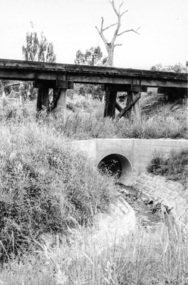
Photograph, Looking west from Main Road from just north of intersection with Diamond Street, Eltham, February 1968, Feb 1968
The watercourse passes under the road and railway at this point. Significant flash flooding occurred along this water course on Christmas Day 2011 causing significant damage to the railway line and road and flooding of Judge Book Village. The drain was swept away including the support pillars of the rail lines timber framework. Judge Book Village had some 40 units flooded before the water entered Diamond Creek. The water had flowed down and flooded Valonia Drive then Grove Street before flowing down the watercourse to Main RoadIn February 1968 an unknown person took a series of photos from the Eltham Hotel at Pitt Street heading north along Main Road through the shopping centre to just north of Elsa Court covering the length of the section of Main Road which was duplicated shortly thereafter. Shows the condition and environment of the streesscape of Main Road, Eltham immediately prior to the duplication between Pitt Street and Elsa Court through the shopping centre. Also shows a number of shops and businesses that operated at that time.Black and white photographduplication, eltham, main road, diamond street, watercourse, drainage, railway line -
 Nillumbik Shire Council
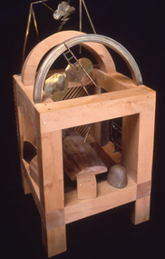
Sculpture: Anthony PRYOR (b.1951- d.1991 Melb, AUS), Paretaio, 1985
In the early 1970s, Arthur Boyd bought and restored a large, two-storey traditional farmhouse called Il Paretaio. Situated on the crest of a hill and surrounded by fields and olive groves, it is five kilometres from the village of Palaia in the province of Pisa, Tuscany. Boyd established this farmhouse as a residency programme, (which was later managed by the Australia Council). The residency program ended in 1990. Anthony Pryor undertook an Australia Council residency at Paretaio in 1984. This work is one in a series made during his time there. This work was entered into the Shire of Eltham Art Award in 1985.Pryor is an artist of national significance. This work is an example of his series of 'boxes' made principally for his own pleasure and often swapped with artists and other friends as soon as they were finished. The 'box' series was part inspired by Japanese techniques of wooden construction. Pryor first visited Japan in 1975 and was immediately drawn to Japanese methods of working with stone and wood. Many of these boxes are based upon the principles of the Japanese Zen Buddhist monk Sengai Gibon (1750-1838). This work relates to Sengai's famous hanging scroll Circle, Triangle and Square in which the circle can be read to stand for the cosmos, the square for the individual, and the triangle for aspiration. A heavy, box-like (cube) structure created from huon pine, with bronze, brass and stone elements. Within the cube is an eastern inspired, rear lattice wall in combination with bronze domestic fittings, and symbols (cube, pyramid and circle). Metal lightning, clouds and wooden rainbow hover over an asymmetrical bronze bed floating within the cube. A chair leans and a tilting ladder reaches towards the sky. Stamped into wood: lower right 'ANTHONY PRYOR PARETAIO'huon pine, pryor, brass, bronze, stone, cube, paretaio, italy, eastern, japan, sengai gibon, symbols, zen buddhism, sculpture, personal -
 Kew Historical Society Inc
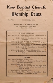
Journal, Kew Baptist Church Monthly News Vol VII November 1932, No. 76
Bi-fold pamphlet on brown paper. Kew Baptist Church Monthly News Vol VII November 1932, No. 76non-fictionkew baptist church -- highbury grove, churches -- kew (vic.), baptist churches, christian-washfold collection -
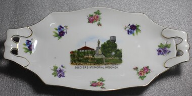 Wodonga & District Historical Society Inc
Memorabilia - Wodonga Soldiers' Memorial Plate, Victoria China, C. 1918 - 1939
A wide range of small china pieces carrying scenic views of holiday destinations or key locations were a popular kind of souvenir during much of the 20th century. Several different pieces were used to depict Wodonga during this period, primarily focusing on the Woodland Grove and the Soldier Memorial. A wide range of souvenirs have been produced to commemorate Wodonga and its landmarks over time. These items document key changes in Wodonga and its heritage. The producers mark on the plate was used by the company Victoria China Czechoslovakia between 1919 and 1938.Small china pieces carrying scenic views of holiday destinations were a popular kind of souvenir during much of the 20th century. These items have local and social significance as they reflect the landmarks or local features valued by the community over time.China Plate, Oblong in shape decorated with flowers and an image of the Soldiers' Memorial in Wodonga in the centre. Makers mark of Victoria China Czechoslovakia which was used from 1918 to1939."SOLDIERS MEMORIAL WODONGA"souvenir, soldiers memorial, wodonga victoria, victoria china, memorabilia -
Glen Eira Historical Society
Article - Athole, Poplar Grove, 18, Carnegie
Two items about this property: 1/Pages 17 and 18 of the Real Estate section of the Caulfield Southern Cross 29/07/1992 including an article on Athole, Poplar Grove, 18, Carnegie, with a sketch of the house and a detained architectural description about its historic features. It also gives a brief history of the house and the life of its designer and owner, architect John T. Kelleher. Names and contact numbers of the Real Estate auctioneers are provided and there are a number of advertisements for other houses in Glen Eira. 2/A photocopy of 2 colour photographs of the exterior and garden of 'Athole' circa 2012.carnegie, poplar grove, athole, kelleher john t, biggin and scott, auctions, stables, stockdale and leggo, glen huntly, wattle avenue, munro avenue, edgewood street, brick houses, glen huntly road, glenhuntly road, j r buxton, caulfield south, pyne street, elsternwick, stanley street, noel jones and associates, brukarz jack, fitch karl, moonya road, wattle avenue, mcpherson street, timber houses, caulfield north, aroona road, dunbar avenue, urandaline grove, lascelles street, mclaurin road, trevelyan street -
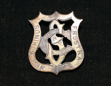 Brighton Historical Society
Badge, School badge, circa 1900s
This Shirley College school badge belonged to Gladys Elvira Linton, nee Richardson (b. 1891). Shirley College was a private girls' school situated in a large single-storey house in Seymour Grove, Brighton from around 1898 until 1912. The school was first run by the Misses Bird and later by Miss Elizabeth Stewart. Gladys married First World War veteran and Brighton local Richard Vivers Linton in 1919. She looked back fondly on her days at Shirley College and helped to organise school reunions well into the 1930s, long after the school itself was gone.Metal Shirley College school badge in the shape of a hollow crest containing the interlocking letters "S" and "C". The back has a hook rather than a proper clasp; possibly it was originally attached to a school hat.Motto engraved around border: "NISI DOMINUS FRUSTRA" (Latin, "without God, [it is] in vain").shirley college, schools, school uniform, 1900s, gladys elvira linton, gladys elvira richardson -
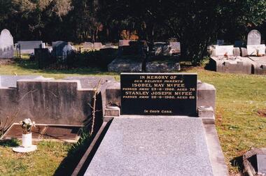 Phillip Island and District Historical Society Inc.
Photograph Album, Kodak, Phillip Island Cemetery, c 1990
The Album was compiled by Nancy McHaffie late 1990's, with the assistance of Edith Jeffery's, with her book "Garden of Memories" and extensive knowledge of Phillip Island. The Cemetery lies back from the road and is surrounded by Manna Gums, rare Peppermint Gums, Blackwoods and other native trees. In all 25 acres of land were set aside as Crown Land in the land settlement of 1868. There are 6.2 acres of wetlands near the cemetery entrance.Stanley Joseph McFee; Stanley was born at Auburn Grove, Auburn on the 23rd January 1892. He was the seventh son of William and Annie McFee. The McFee family moved to Rhyll in 1894 where Stanley was educated at the Rhyll School. Later he took up farming at Long Point, now known as McFees Road. In 1917 Stanley married Isabell May Cherry who came to Rhyll in 1912 as the school teacher. His wife May supported him in his community activities. Stanley died 1980 aged 88. Isabell May died 1966 aged 78. phillip island cemetery, stanley mcfee, isabell mcfee, nancy mchaffie, edith jeffery -
 Ringwood and District Historical Society
Work on paper - Pencil sketch, Artist unknown, initials D.M, Sketch of pottery kilns at East Ringwood, corner of Velma Grove and Mount Dandenong Road (Oxford Road). Kilns shut down in 1926, c.1926
Sketch of the four pottery kilns at East Ringwood, corner of Velma Grove and Mount Dandenong Road (Oxford Road). The kilns shut down in 1926. Judging by the handwriting, the artist and author appears to be John Rodaughan, East Ringwood historian, whose other works include history on Burnt Bridge Hotel and other parts of East Ringwood. The back of the sketch includes a rough hand-drawn map, that appears to be of the insulator works area, between Mt Dandenong Road and Evon Avenue. The timeline includes generic milestones in blue ink and those associated with Ringwood in red writing.Kilns; D.M. -
 Wodonga & District Historical Society Inc
Photograph - Mann Collection Album - Melba Hall/old Shire Offices and Dr. Grant’s Surgery, C. 1960s - 1970
Elaine Mann was married to David Mann, a successful Wodonga businessman and community leader who passed away in Wodonga in June 2012. David was a member of the Mann family who began their business in Wodonga in 1920. Elaine was a teacher in Wodonga for many years and an active member of the community.This photo collection is of significance as it documents how the businesses and buildings in Wodonga have evolved and contributed to community throughout the late 20th century.Melba Hall/old Shire Offices and Dr. Grant’s Surgery located on the corner of High Street and Melbourne Road. The building was constructed in 1890. Dr. Grant Sr.'s Surgery was in the house on the left. These were Wodonga’s second shire offices. The Wodonga Council operated from these chambers from 1890 until 1957 when they moved to Woodland Grove building. The Gas Company then took over the old Shire Hall. The entrance to the Melba Theatre is on the far right. The Melba Theatre screened its last film in 1968. The building was demolished in 1971 to make way for a Safeway supermarket and car park.On front of the building above door "GAS SUPPLY/ CO."wodonga businesses, high st wodonga, dr. grant, melba hall -
 Eltham District Historical Society Inc
Photograph, Frank Stokes with daughters Dorothy (left) and Beryl (right) at Stokes Orchard, Nyora Road, Eltham, 1944, 1944
Frank Stokes first traveled to the district by train in 1944 to find land with the intention to establish an orchard. By chance he met Arthur Bird of Bird Orchard (bounded by Pitt Street, Eucalyptus Road and Wattle Grove) and they got talking over their common interest. Arthur put Frank up for the night and pointed out the land, part of Crown Allotment 15, Section 5, Parish of Nillumbik (CA15) somewhat diagonally opposite Bird Orchard. Frank bought the land and for the next two years would travel by train from Melbourne to Eltham every weekend establishing Stokes Orchard and building a home for his family, which they eventually moved into in 1946. In the mid 1970s the Shire of Eltham divided the orchard up into numerous rate-able parcel lots, which became affordable for Frank. As a consequence Stokes Orchard was turned into a housing development by Macquarie Builders and marketed as the Stokes Orchard Estate in two stages; Stage 1 encompassing Scarlet Ash Court, Ironbark Close and Peppermint Grove bounded by Nyora and Eucalyptus roads c.1976 and Stage 2 encompassing Stokes Place, Orchard Way, The Crest and The Lookout bound by Nyora and Diosma roads c.1979. The development of Orchard Way, The Crest and The Lookout did not proceed as planned due to the lack of the sewer along Diosma Road and so many of the proposed lots were incorporated into five-acre parcels instead.Representative of the orchard growing areas of ElthamDigital file only - Digitised by EDHS from a scrapbook (containing commercially printed photos of digital scans) on loan from Beryl Bradbury (nee Stokes), daughter of Frank Stokes.1944, beryl bradbury (nee stokes), beryl bradbury (nee stokes) collection, dorothy stokes, eltham, frank stokes, nyora road, stokes orchard -
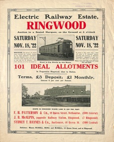 Ringwood and District Historical Society
Flyer, Land Sale Auction Brochure, Electric Railway Estate, Ringwood, Vic. - 1922
Bi-folded single sheet with black and red print both sides advertising auction of allotments on Saturday, November 18, 1922, including details of subdivision features and local facilities. Subdivision includes Bedford Road, Williams Grove, Campbell Street, Myrtle Avenue, George Street, and Henry Street. Agents - F.H. Patterson & Co., 19 Queen Street, Melbourne, Tel. 4308 Central, J.B. McAlpin, Opposite Railway Station, Ringwood, Tel 7 Ringwood, SYDNEY T. Haynes & Co., Auctioneer, 60 Queen Street, Melbourne, Tel 3400 Central. -
 Eltham District Historical Society Inc
Photograph - Aerial Photograph, Landata, Eltham, Vic, Apr. 1963
Centred on present day John Street, Eltham between Main and Bible streets bounded by Elsa Court to north, Main Road Bridge to south, Wattle Grove to east and Bolton Street to west. Historic Aerial Imagery Source: Landata.vic.gov.au Aerial Photo Details: Project No :486 Project : MELBOURNE (1963) PROJECT Run : 6 Frame : 123 Date : 04/1963 Film Type : B/W Camera : RC8 Flying Height : 5100 Scale : 9600 Film Number : 1805 GDA2020 : 37°43'12"S, 145°08'54"E MGA2020 : 336800, 5823623 (55) Melways : 21 J6 (ed. 42)aerial photo, neil webster collection, 1963-04, bolton steet, elsa court, eltham, john street, main road, main road bridge, melway 21j6, wattle grove -
 Kew Historical Society Inc
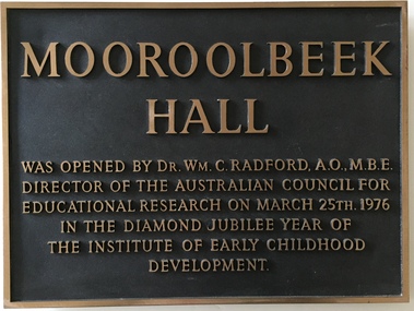
Plaque, Institute of Early Childhood Development, Mooroolbeek Hall, 1976
The Free Kindergarten Union of Victoria commenced teacher training in 1909. A two year course was run in cooperation with the Education Department in 1910-14, but from 1917 the Union trained its students independently. In 1922 the Kindergarten Training College was established in Mooroolbeek, Kew. In 1965, the institution, as the Melbourne Kindergarten Teachers' College, became an entity separate from the Union, and in 1973 joined the State College of Victoria as the Institute of Early Childhood Development. It subsequently amalgamated with the University of Melbourne to become the Department of Early Childhood Studies and moved from Madden Grove, Kew, to 234 Queensberry St, Carlton, early in July 1997.Metal plaque commemorating the opening of Mooroolbeek Hall in the Diamond Jubilee Year of the Institute of Early Childhood Development in KewMooroolbeek Hall was opened by Dr Wm C. Radford, AO, MBE, Director of the Australian Council for Educational Research on March 25th 1976 in the Diamond Jubilee Year of the Institute for Early Childhood Developmentinstitute of early childhood development - kew (vic), dr william c. radford, memorial plaques - kew (vic), mooroolbeek hall -
 Kew Historical Society Inc
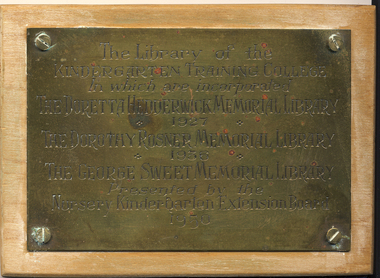
Plaque - Commemorative Plaque, Institute of Early Childhood Development, Opening of the Library of the Kindergarten Training College, Kew, 1950, 1950
The Free Kindergarten Union of Victoria commenced teacher training in 1909. A two year course was run in cooperation with the Education Department in 1910-14, but from 1917 the Union trained its students independently. In 1922 the Kindergarten Training College was established in Mooroolbeek, Kew. In 1965, the institution, as the Melbourne Kindergarten Teachers' College, became an entity separate from the Union, and in 1973 joined the State College of Victoria as the Institute of Early Childhood Development. It subsequently amalgamated with the University of Melbourne to become the Department of Early Childhood Studies and moved from Madden Grove, Kew, to 234 Queensberry St, Carlton, early in July 1997.Small brass plaque mounted on wood commemorating the libraries of the Kindergarten Training College in Kew.The library of the Kindergarten Training College in which are incorporated the Doretta Hedderwick Memorial 1927, the Dorothy Rosner Memorial 1936, the George Sweet Memorial Library - Presented by the Nursery Kindergarten Exrension Board 1950institute of early childhood development - kew (vic), libraries - education - early childhood - kew (vic), doretta hedderwick memorial library 1927, dorothy rosner memorial library 1936, george sweet memorial library, nursery kindergarten exrension board -
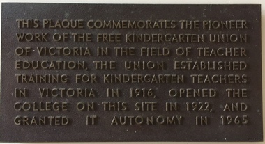 Kew Historical Society Inc
Plaque - Commemorative Plaque, Free Kindergarten Union of Victoria, Commemoration of the Free Kindergarten Union of Victoria, circa 1965, c.1965
The Free Kindergarten Union of Victoria commenced teacher training in 1909. A two year course was run in cooperation with the Education Department in 1910-14, but from 1917 the Union trained its students independently. In 1922 the Kindergarten Training College was established in Mooroolbeek, Kew. In 1965, the institution, as the Melbourne Kindergarten Teachers' College, became an entity separate from the Union, and in 1973 joined the State College of Victoria as the Institute of Early Childhood Development. It subsequently amalgamated with the University of Melbourne to become the Department of Early Childhood Studies and moved from Madden Grove, Kew, to 234 Queensberry St, Carlton, early in July 1997.Plaque recognising the site of an important educational institution for teacher training.Bronze plaque with raised lettering commemorating the role of the Free Kindergarten Union of Victoria which had opened in 1916"This plaque commemorates the pioneer work of the Free Kindergarten Union of Victoria in the field of teacher education, the Union established training for kindergarten teachers in Victoria in 1916, opened the college on this site in 1922, and granted it autonomy on 1965."institute of early childhood development - kew (vic), free kindergarten union of victoria, early childhood education - kew - victoria -
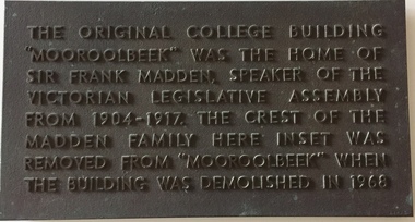 Kew Historical Society Inc
Plaque - Commemorative Plaque, Institute of Early Childhood Development, 'Mooroolbeek', Madden Grove, Kew, c.1968
The Free Kindergarten Union of Victoria commenced teacher training in 1909. A two year course was run in cooperation with the Education Department in 1910-14, but from 1917 the Union trained its students independently. In 1922 the Kindergarten Training College was established in Mooroolbeek, Kew. In 1965, the institution, as the Melbourne Kindergarten Teachers' College, became an entity separate from the Union, and in 1973 joined the State College of Victoria as the Institute of Early Childhood Development. It subsequently amalgamated with the University of Melbourne to become the Department of Early Childhood Studies and moved from Madden Grove, Kew, to 234 Queensberry St, Carlton, early in July 1997.Commemorative plaque indicating the location of a former Kew mansionBronze plaque commemorating the location of Mooroolbeek, one of the great mansions of Kew, demolished in 1968 by the Kindergarten Training College"The original college building "Mooroolbeek" was the home of Sir Frank Madden Speaker of the Victorian Legislative Assembly from 1904-1917. The crest of the Madden family here inset was removed from "Mooroolbeek" when the building was demolished in 1968."institute of early childhood development - kew (vic), mooroolbeek - madden grove - kew (vic), sir frank madden -
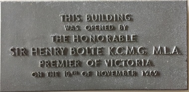 Kew Historical Society Inc
Plaque - Commemorative Plaque, Institute of Early Childhood Development, This building was opened by the Honorable Sir Henry Bolte KCMG MLA, Premier of Victoria, on the 10th December 1969, 1969
The Free Kindergarten Union of Victoria commenced teacher training in 1909. A two year course was run in cooperation with the Education Department in 1910-14, but from 1917 the Union trained its students independently. In 1922 the Kindergarten Training College was established in Mooroolbeek, Kew. In 1965, the institution, as the Melbourne Kindergarten Teachers' College, became an entity separate from the Union, and in 1973 joined the State College of Victoria as the Institute of Early Childhood Development. It subsequently amalgamated with the University of Melbourne to become the Department of Early Childhood Studies and moved from Madden Grove, Kew, to 234 Queensberry St, Carlton, early in July 1997.Metal alloy plaque commemorating the opening of a building by the Premier of Victoria, Sir Henry Bolte, on 10th December 1969This building was opened by the Honorable Sir Henry Bolte KCMG MLA, Premier of Victoria, on the 10th December 1969sir henry bolte, commemorative plaques - kew (vic), institute of early childhood development -
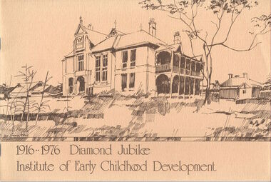 Kew Historical Society Inc
Booklet, Institute of Early Childhood Development, 1916-1976 Diamond Jubilee, 1976
The Free Kindergarten Union of Victoria commenced teacher training in 1909. A two year course was run in cooperation with the Education Department in 1910-14, but from 1917 the Union trained its students independently. In 1922 the Kindergarten Training College was established in Mooroolbeek, Kew. In 1965, the institution, as the Melbourne Kindergarten Teachers' College, became an entity separate from the Union, and in 1973 joined the State College of Victoria as the Institute of Early Childhood Development. It subsequently amalgamated with the University of Melbourne to become the Department of Early Childhood Studies and moved from Madden Grove, Kew, to 234 Queensberry St, Carlton, early in July 1997.[16]p. : ill., ports. ; 19 x 28 cm. Includes photographs of the Institute, its leaders and students. Included are a chronology and a number of photos (above) of Mooroolbeek, part of the complex, which is now all demolished.institute of early childhood development, mooroolbeek -
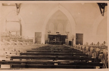 Kew Historical Society Inc
Postcard - Interior, Kew Baptist Church, 1920s
The Kew Baptist Church was originally located on the corner of Cotham Road and St John’s Parade. In 1922, work commenced on a new, larger church in Highbury Grove. The foundation stone of the new building was laid by Cr Ratten of the City of Kew on Saturday 14 October 1922, with the First Kew Scouts forming a guard of honor. A collection taken up at the laying of the foundation stone raised £454. The site and building cost approximately £6,000. The architects for this new red brick ‘semi-Gothic’ church were Messrs Gawler & Drummond. The interior of the church accommodated 500 parishioners. The seating sloped towards the pulpit with no columns obstructing the view of the worshippers. Faded sepia 'real photo' Kodak postcard of the interior and altar of Kew Baptist Church "Interior of Kew Baptist Church"kew baptist church -- highbury grove, churches -- kew (vic.), baptist churches, christian-washfold collection -
 Kew Historical Society Inc
Photograph - Willsmere [Kew] Billabong, 1993
Willsmere Park is bounded by the the Yarra River, Green Acres Golf Club, Willow Grove and the Eastern Freeway. The land on which the park is now situated was bought by Thomas Wills at the Crown Land Sales of 1846 (Section 56). From the 1840s to the 1940s it was intensively farmed. The park is dominated by very large playing fields, while planting to the southern boundary was undertaken when the Eastern Freeway was built. It is only along the banks of the Yarra that there is any remnant native vegetation. Willsmere Park is of significance as an area of open land that remains from the flood plain that once dominated northern Kew. (Source: Kew Conservation Study, 1988)Original colour small format polaroid photograph of the 'Kew Billabong' in the Willsmere Park, taken on 16 September 1993."Willsmere Billabong 16.9.93"kew billabong, willsmere park, yarra river -- billabongs -
 Kew Historical Society Inc
Photograph - Yarra River in flood at the Willsmere Park, 1993
Willsmere Park is bounded by the the Yarra River, Green Acres Golf Club, Willow Grove and the Eastern Freeway. The land on which the park is now situated was bought by Thomas Wills at the Crown Land Sales of 1846 (Section 56). From the 1840s to the 1940s it was intensively farmed. The park is dominated by very large playing fields, while planting to the southern boundary was undertaken when the Eastern Freeway was built. It is only along the banks of the Yarra that there is any remnant native vegetation. Willsmere Park is of significance as an area of open land that remains from the flood plain that once dominated northern Kew. (Source: Kew Conservation Study, 1988)Original colour small format polaroid photograph of the Yarra River in flood at the Willsmere Park, taken on 16 September 1993."Yarra River at Willsmere Park Flooding 16.9.93"willsmere park, yarra river -- floods -- kew (vic.) -
 Kew Historical Society Inc
Photograph - Flooding in the Willsmere Park, 1993
Willsmere Park is bounded by the the Yarra River, Green Acres Golf Club, Willow Grove and the Eastern Freeway. The land on which the park is now situated was bought by Thomas Wills at the Crown Land Sales of 1846 (Section 56). From the 1840s to the 1940s it was intensively farmed. The park is dominated by very large playing fields, while planting to the southern boundary was undertaken when the Eastern Freeway was built. It is only along the banks of the Yarra that there is any remnant native vegetation. Willsmere Park is of significance as an area of open land that remains from the flood plain that once dominated northern Kew. (Source: Kew Conservation Study, 1988)Original colour small format polaroid photograph of flooding in the Willsmere Park, taken on 16 September 1993."Flooding of shared path from Willsmere Billabong 16.9.93"willsmere park, yarra river -- floods -- kew (vic.), kew billabong