Showing 3154 items matching "miles"
-
 Bendigo Historical Society Inc.
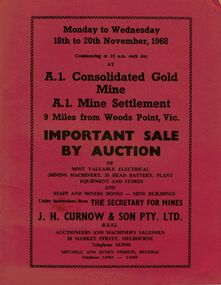
Document - IAN DYETT COLLECTION: AUCTION CATALOGUE - A1 CONSOLIDATED GOLD MINE
Three red covered auction catalogues for a sale on the 18th to 20th November, 1968 at the A.1. Consolidated Gold Mine A.1. Mine Settlement, 9 Miles from Woods Point, Vic. For sale was Most Valuable Electrical Mining Machinery, 20 Head Battery, Plant Equipment and Stores and Staff and Miners Homes - Mine Buildings Under Instruction from The Secretary for Mines. Also for sale was the Lease No. 8317 Beechworth. Catalogue has a Sketch Plan showing Mine Property.business, auctioneers, j h curnow & son pty ltd, ian dyett collection - auction catalogue - a1 consolidated gold mine, the secretary for mines, j h curnow & son pty ltd, f c dyett, l c osborne, clem hill, t apps, bolton's print -
 Bendigo Historical Society Inc.
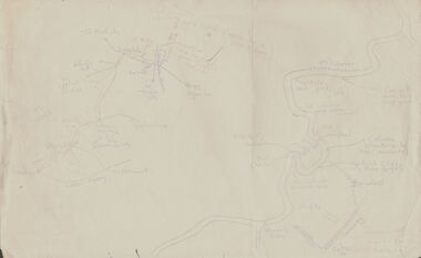
Document - PETER ELLIS COLLECTION: SKETCH OF THE BARFOLD GORGE
Two hand sketched maps on same sheet of paper, one of the location of the Barfold Gorge in relation to surrounding towns, Mt Alexander and Turpin;s Falls. The second map is a part of the Campaspe River location of the Barfold Gorge. Shown is the location of columns, pools, type of rock, Mitchell's Falls, tunnel, cave, Queen's Falls, house, windmill, fences and places where access to the bottom of the gorge is possible. Car track and scale of 1 mile = 6 inches are also shown.place, land, barfold gorge, peter ellis collection, mitchell's falls, queen's falls, turpin's falls -
 Bendigo Historical Society Inc.
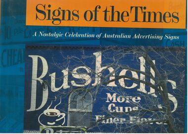
Book - Signs of the Times
Well-known as an artist, author, historian, illustrator and publisher, Geoff Hocking grew up in the goldfields city of Bendigo and lives today in Castlemaine. His work reflects a passion for the heritage of the goldfields region. https://artsopen.com.au/wp-content/uploads/2021/11/geoff-hocking-CV-2019.pdf Full title. "Signs of the Times. A nostalgic Celebration of Australian Advertising Signs. Written by Geoff Hocking. Published by Five Mile Press in 2007. Hard cover book with dust jacket. Blue and gold colouring. Front cover has a picture of a Bushells sign on a brick wall with a peters Ice cream sign in the corner. Back cover has eight smaller advertising signs. 228 pp. containing advertising signs from across Australia with historical notes and descriptions.signs, geoff hocking, photographs, advertising -
 Melbourne Tram Museum
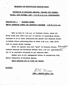
Document - Memorandum, Melbourne & Metropolitan Tramways Board (MMTB), "Procession of Munitions Vehicles, through city streets", Oct. 1943
2 copies of letter from HS Wootton, Town Clerk, City of Melbourne, titled "Arrangements in connection with "Miles of Munitions 1943" procession through city streets on Friday 29th October, 1943, in connection with Fourth Liberty War Loan". Provides details of route and assembly points with tram requirements. Dated 21 Oct 1943 8 memos from JM Harry, Dist Traffic Supt SS regarding tram arrangements to various inspectors. Memos dated 27/10/1943."Mr Harry" written in pencil on one letter. "Coburg depot" written on 2 memos. Several comments written in pencil regarding tram scheduling.trams, tramways, events, parades, world war 2, coburg depot, hanna st depot, malvern depot, hawthorn depot, camberwell depot, glenhuntly depot, victoria st, swanston st, elizabeth st, spencer st, collins st -
 Melbourne Tram Museum
Map, Ministry of Transport, "Metropolitan Transport Services Map - Melbourne Tram, Train and Bus Services", 10/1971
Fold out map (27 sections 9 across x 3 deep), coloured of Melbourne's Tram and Bus routes, route numbers, rail lines, detailed for the central part of Melbourne. On rear description of routes, private bus routes and map of Melbourne metro lines. Has contact details for bookings and lost property etc. Priced at 10c. Launched in a newspaper advert 26/10/1971. Has map scale in miles. 2nd copy added 16/7/2014On front cover in ink "#1" in top right hand corner and "4 G 33" along bottom edge.trams, tramways, melbourne, map, tram & bus services, railways, mmtb, minister for transport -
 Bendigo Historical Society Inc.
Map - PETER ELLIS COLLECTION: MAP OF WHIPSTICK
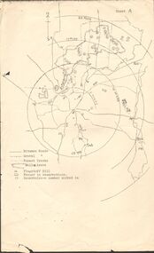
Two maps of the Whipstick - Sheet A and Sheet B. Sheet A shows the Whipstick in relation to Bendigo and some surrounding places. Bitumen roads, gravel, forest tracks, Mallee Areas, Flagstaff Hill, fenced in reservations and reservoirs are marked. Also, a circle and part circles of 5-, 10-, 15- and 20-mile radius is marked. North & South are marked. Sheet B is an enlarged area of the Whipstick Scrub area. North and South is marked. There are a number of letters written over both maps.map, bendigo, peter ellis collection, the whipstick, flagstaff hill -
 Dandenong/Cranbourne RSL Sub Branch
Document - Framed Recognition Certificate, District of Dalesford
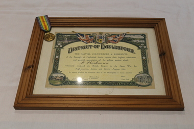
This is a certificate presented to 2156 Private Christopher Dennis Parkinson who enlisted on 4 April 1916, served in 2nd Pioneer Battalion A.I.F. He was Wounded In Action and died form gunshot wound (abdomen) on 22 December 1917 in Belgium. He is buried in Trois Arbres Military Cemetary, STRENWERCK, 3 and a half miles N.W of Armentieres. Plot 2; Row C; Grave 16. He received the 1914/15 Star; British War Medal and Victory Medal.District of Daylesford. Presented by the Mayor Councillors & Residents. -
 Orbost & District Historical Society
saddle, C 1910-1930
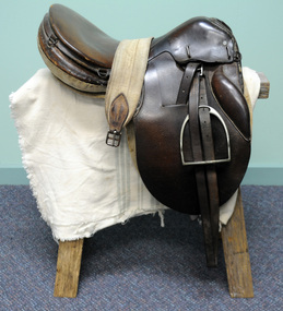
This saddle was used by Nancy Bland in 1934 when she rode Silver King from Coonalpyn in South Australia to Melbourne - a distance of 370 miles. The trip took took seven days and four hours. Nancy did this trip as a personal challenge.A brown leather saddle with stirrups and cloth girth.equestrian saddle -
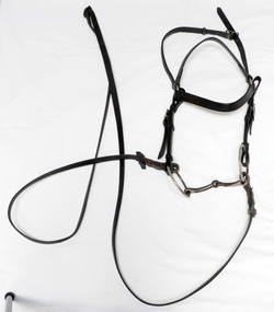 Orbost & District Historical Society
bridle and reins, first half 20th century
This item was used by Nancy Bland in 1934 when she rode Silver King from Coonalpyn in South Australia to Melbourne - a distance of 370 miles. The trip took took seven days and four hours. Nancy did this trip as a personal challenge. Horse bridle and reins made of narrow brown leather straps with metal attachments.equestrian reins bridle -
 Kew Historical Society Inc
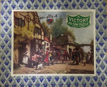
Leisure object - Jig-Saw Puzzle, Hayter & Co, Victory Jig-Saw - V.2149 The New Mount, c.1935
The Victory Jig-Saw Puzzles were made by Gerald Hayter in England between the late 1920s through to the 1970s. They had wooden pieces and were very popular in the 1940s and 1950s. The puzzle was owned by the donor's mother, Iduna Miles (nee Sutton).A Victory Jig-Saw puzzle in its original cardboard box. Victory Jig-Saw puzzles were a popular series made by Hayter & Co., Bournemouth, UK.jig-saw puzzle, hayter & co, victory jig-saw puzzles -
 Port Fairy Historical Society Museum and Archives
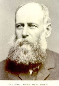
Photograph, Cr G Lydiard Belfast Shire President 1877-78-79, 83-84 88-90
George Lydiard occupied the station “Korongah” and with Mr J Knight carried out extensive drainage works from Tower hill to the Belfast Lough. This drain was constructed over a period of two years, is six miles long and some of it still exists.Black and white portraitbelfast, president, portrait, shire, council, municipal, local-government, korongah, g.lydiard -
 Bendigo Military Museum
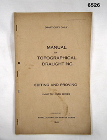
Document - Royal Australian Survey Corps - Manual of Topographical Draughting - Editing and Proving 1949, Royal Australian Survey Corps, 1949
This Draft document is part of the Topographical Drafting Manual produced by the Royal Australian Survey Corps in 1949. This document covers the guidelines for Editing and Proving (quality control) of the 1 Mile to 1 Inch map series that was widely produced by the Corps over Australia.A 10 x page foolscap sized buff coloured covered document, stapled and two hole punchedStamped on cover "E Comd Field Survey Unit"royal australian survey corps, rasvy, fortuna, army survey regiment, army svy regt, asr -
 Bendigo Historical Society Inc.
Document - PETER ELLIS COLLECTION: BENDIGO NORTH PRIMARY SCHOOL CHILDREN'S BALL, 18th August, 1983
Bendigo North Primary School Children's Ball held at the White Hills Technical School on Thursday 18th August 1983. Front page has drawings of clouds,ants, bees, mushrooms, butterflies and caterpillars. On the inside is the names of 16 dances and a representation of subjects. The back page has acknowledgements to people who assisted the ball. They include: Heather and Noel Ridge, Lloyd George, David Tunley, Greg Taska, Di Milich, Merilyn Tatt, Brian and Roger Hillman, Mark Walters, Jim McDonald, Lexie Ottery, Peter Ellis, John Ottery, Jenni Hillman, Fay McCaig, Elaine Price, Ruth Sloan, Lesley Campbell, Joan McColl, Connie Kairns, Janet Holland, Val Lee, Sandra Kaska, Evelyn Bruhn, Marg Gilbee, Ken Miles, Joy Miles, Helen Penna, Ken Gilbee, Marg Gilbee, Jane Pattinson, Jenny Mollison, Coral McClure, Maureen Warren, Robyn Murphy, Olga Chafer, Deanne McNeil, Carol Canfield, Sandra Kaska, Lesley Revert and Neil Ross.entertainment, dance, ball, peter ellis collection, bendigo north primary school children's ball, white hills technical school, peter ellis, bendigo north primary school, heather and noel ridge, lloyd george, david tunley, greg taska, di milich, merilyn tatt, brian and roger hillman, mark walters, jim mcdonald, lexie ottery, john ottery, jenni hillman, fy mccaig, elaine price, ruth sloan, lesley campbell, joan mccoll, connie kairns, janet holland, val lee, sandra kaska, evelyn bruhn, marg gilbee, ken miles, joy miles, helen penna, ken gilbee, marg gilbee, jane pattinson, jenny mollison, coral mcclure, maureen warren, robyn murphy, olga chafer, deanne mcneil, carol canfield, sandra kaska, lesley revert, neil ross -
 Warrnambool and District Historical Society Inc.
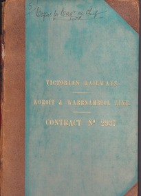
Document - Victorian Railways. Koroit & Warrnambool Line. Contract No. 2937, Circa 1888
The Victorian Railways began in 1854 and in the first 14 years up to 1868 had managed to complete about 250 miles of track. The next 60 years saw the system expand to nearly 3000 miles. By 1931 every town with a population over 500 had its own railway station. Early Victorian railway maps indicate that the extension from Colac to Warrnambool and then onwards to Koroit, occurred in the period of the 1880’s when the act known as the Octopus act saw a rapid expansion of lines. At the time there was much debate over where the expansion of the lines should take place, with one of the prime considerations for Warrnambool was the impact it would have on its port.The building of the railway to Warrnambool and onward to Koroit was a significant event for the town. Green cloth cover with tan suede corner points and spine. Title printed in gold on front cover. Title printed in gold on red on spine. 92 pages. The contract is printed and includes handwritten entries with specifications.Handwritten on front cover and inside front cover ” Copy for Engr in Chief” .On Page 2 transferred to Allan Reid * 24/1/88 Co Briscoe & Co Little Collins Street, Melbourne.warrnambool, railways, warrnambool to koroit railway, victorian railways contract no 2937 -
 Ballarat Heritage Services
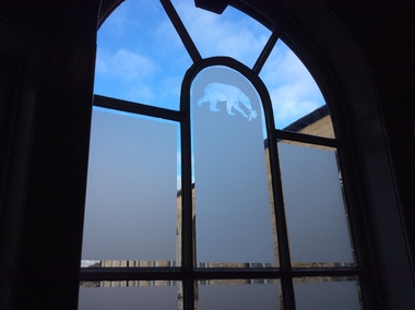
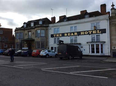
Photograph - Colour, The Bear Hotel, Devizes, England
Devizes is a medieval market town in the centre of Wiltshire, 16 miles from Stonehenge and 8 miles from Avebury. The building of a castle in Norman times dictated the layout of the town which is still visible. It contains over 50 Heritage Plaques. There were people in Devizes locality in prehistoric times and a Roman villa once stood on The green. The Wiltshire Museum is home to one of the best Broze Age collections in Britain and includes finds from around Stonehenge including the famous Bush Barrow gold. Some convicts that were tried at the Devizes Assizes were transported to Australia. Amongst these was John Chew, transported to Tasmania, but later his family settled in Victoria.devizes, the bear hotel, staircase, window -
 Ballarat Heritage Services
Photograph - Colour, The Bear Hotel, Devizes, England
Devizes is a medieval market town in the centre of Wiltshire, 16 miles from Stonehenge and 8 miles from Avebury. The building of a castle in Norman times dictated the layout of the town which is still visible. It contains over 50 Heritage Plaques. There were people in Devizes locality in prehistoric times and a Roman villa once stood on The green. The Wiltshire Museum is home to one of the best Bronze Age collections in Britain and includes finds from around Stonehenge including the famous Bush Barrow gold. Some convicts that were tried at the Devizes Assizes were transported to Australia. Amongst these was John Chew, transported to Tasmania, but later his family settled in Victoria.devizes, the bear hotel, staircase, window -
 Ballarat Heritage Services
Photograph - Colour, Dorothy Wickham, Monument in Town Square, Devizes, England, 2017
Devizes is a medieval market town in the centre of Wiltshire, 16 miles from Stonehenge and 8 miles from Avebury. The building of a castle in Norman times dictated the layout of the town which is still visible. It contains over 50 Heritage Plaques. There were people in Devizes locality in prehistoric times and a Roman villa once stood on The green. The Wiltshire Museum is home to one of the best Bronze Age collections in Britain and includes finds from around Stonehenge including the famous Bush Barrow gold. Some convicts that were tried at the Devizes Assizes were transported to Australia. Amongst these was John Chew, transported to Tasmania, but later his family settled in Victoria.devizes, bear hotel, staircase, window -
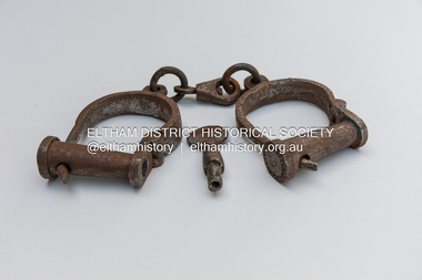 Eltham District Historical Society Inc
Equipment, Handcuffs
Typical of the late 1800s era for Police use, these particular handcuffs were salvaged from the rear of the abandoned Wanarring Police Station, part of the Bourke Police District, 194 miles northwest of Bourke. Most likely made by a local blacksmith to a standard design Metal handcuffs and key with surface rust110 on keyhandcuffs, police -
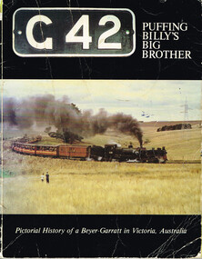 Otway Districts Historical Society
Book, Puffing Billy Preservation Society, G42: Puffing Billy's Big Brother, 1981
Victoria's narrow gauge railways were from Wangaratta to Whitfield (covering 30.5 miles/49 km) opening in 1899, Colac to Beech Forest (29 miles/46.7 km) opening in 1902 with an addition to Crowes (14.1 miles/22.7 km) opening in 1910, Upper Ferntree Gully to Gembrook (18.2 miles/29.3 km) opening in 1900, and Moe to Walhalla (26 miles/41.3 km) opening in 1910. From the outset these narrow gauge lines proved very uneconomical in operation and were plagued with continuing financial losses. The lines most difficult to work were those carrying the most business, and in particular the trains from Colac and Moe with their 1 in 30 grades and countless curves precluded having engines with large coupled driving wheels operating. Having examined the possible use of articulated locomotives to reduce operating costs on the narrow gauge lines the Victorian Railways decided upon the Beyer-Garratt type of locomotive in 1925 and an order was placed in England for two engines of the 2-6-0 plus 0-6-2 wheel arrangements. These arrived in April 1926. Assembly of the new Garratts was duly completed and steaming trials carried out at Newport, Victoria, the engines being classed as "G" and given the running numbers "41" and "42". G41 was taken to Colac where, on 5 June 1926, it was put to work on the Colac-Beech Forest-Crowes line. G42 soon followed and duly began work on the equally steep and tortuous but shorter Moe-Walhalla line. Following the closure of the Moe line in 1955 G42 was refurbished and went to Colac. G41 was overhauled, but not as thoroughly as G42, at then returned to Colac where both Garratts shared regular work on the line until its closure in 1962. From 1978 G42 continues its operation on the Upper Ferntree Gully-Gembrook line as part of the Puffing Billy Preservation Society.G42: Puffing Billy's Big Brother. Pictorial history of a Beyer-Garratt in Victoria, Australia. Phil A'Vard, Larry James, Ron Peach (concept). Puffing Billy Preservation Society; Belgrave (Vic); 1980. 64 p.; illus; map. Soft cover. ISBN 0 9598392 7 5victorian railways; narrow gauge; moe; walhalla; colac; beech forest; crowes; upper ferntree gully; gembrook; beyer-garratt; -
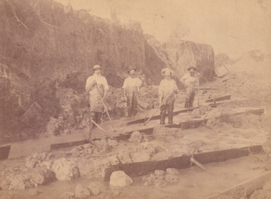 The Beechworth Burke Museum
Photograph, c.1870
This photograph was taken in approximately 1870 and depicts four male miners standing in mining sluice at the Three Mile Goldfields. These men are wearing typical attire for 1870s gold miners. They wear white shirts, tan coloured pants with water proof shoes and most of the men are wearing an apron to prevent their clothing from becoming too dirty from the mud. Each man is wearing a wide brim hat and hold large wooden tools used for sorting through the sluice. Three of the four men have full beards. The photograph was donated to the Burke Museum by R. Ziegenbein before 2001 but the photographer and the individuals captured in the photo are unknown. The image depicts the landscape of the Three Mile Goldfields during a period when open cut sluicing was undertaken to reach gold. Open cut sluicing is a method used to extract gold and other precious metals from beneath the surface of the earth. This technique involved the use of high-powered hoses which broke down the soil enabling miners to come along and search this soil for gold. After the gold rush of the early 1850s, diggers had to enlist the assistance of heavy machinery and techniques like hydraulic sluicing in order to reach gold because the surface alluvial gold had already been discovered and removed. This heavy machinery was not used until after 1853. The Three Mile Goldfields was a site of rich alluvial gold deposits located about 5 km south of Beechworth in Victoria. Today, the location of this gold deposit is called Baarmutha. It was a popular area for gold mining in the 1850s but became largely abandoned by the following decade. In 1865, a man named John Pund recognized that the area could be potentially rich if a better water supply could be obtained. He secured a 15 year license with three other miners. Within the next five years, these men had constructed 19 km of water race going from Upper Nine Mile Creek to Three Mile Creek. By 1881, these four men had delivered 950,000 gallons to the Three Mile Sluicing area which is depicted in this photograph. Pund was later go into partnership with John Alston Wallace who would become owner of the Star Hotel in Beechworth. The Three Mile sluicing location continued to be operational until 1950. Sluice box workers were a vital part of gold mining regardless of how inefficient they were in the recovery of gold. After using hydraulic sluicing to cut away the earth, miners would use the big wooden boxes depicted in the image to catch the earth which would then be sifted for gold. However, accidents would occur often which would result in the gold washing away and unable to be recovered. It was not a very efficient system because the gold, which was alluvial and thus very fine, would often pass through the sluice box undetected.The search for gold is ingrained into the history of Victoria and therefore, images like this one which portray an open cut sluicing site can reveal important information for society and technology for the date when the photograph was taken. This image is of important historical significance for its ability to convey information about sluicing and the methods used to find gold in the late 1800s and early 1900s. It also shows a location where sluicing was undertook which provides insight into the impact of sluicing on the environment at a time when it was done. Images, like this one, of Australian gold rush history can reveal important information about the social and environmental impact of this period. This image depicts diggers standing in a mining location and therefore, this image has the capacity to reveal or support significant information for researchers studying the fashion and social status of diggers in Australia in approximately 1870. It can also provide information on the landscape of Australia in this period and the impact of mining for gold on both society and the Australian landscape. The Burke Museum is home to a substantial collection of Australian mining photographs which can be used to gain a deeper understanding into life on the gold fields, technology used in mining, the miners themselves and the impact of the gold digging on the environment.Sepia toned rectangular photograph printed on matte photographic paper and mounted on board.[illegible] about 1870 / 97 2514.1 / 2594 30three mile goldfields, goldfields, 1870, 1870 gold, australia, australian landscape, miners, gold miners, diggers, gold diggers, beechworth, victoria, sluice box workers, sluicing, sluice, mining -
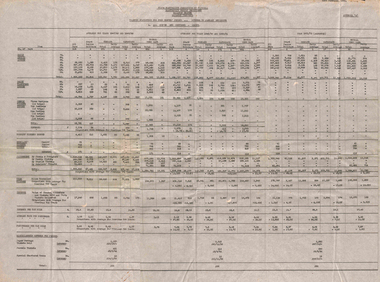 Ballarat Tramway Museum
Administrative record - Ballarat, State Electricity Commission of Victoria (SECV), "Traffic Statistics for four months period", 2/1952
Set of four typed documents dated 23/2/1952: Appendix A - All routes and Sections - Adults Appendix B - City to Sebastopol and other routes Appendix C - One section on all routes and city sections Appendix D - Summary of comparisons with average for previous two years. Sets out tables for 1947/48, 1949/50 and 1951/52. Gives information on tickets and transfers issued, weekly tickets, tourist tickets issue, scholar's tickets issued, passengers, tram mileages, revenue, revenue per car miles, average fare per passengers, passengers per car miles, and misc. revenues - papers, parcel tickets and special chartered trams.Yields information about the type of traffic reports prepared by the SECV Ballarat to provide detail of passengers carried, tramcar mileages, and statistics.Set of four large format sheets, heavily creased, typed originals.tramways, ballarat, reports, traffic, weekly tickets, transfer tickets, secv, revenue, statistics -
 Kiewa Valley Historical Society
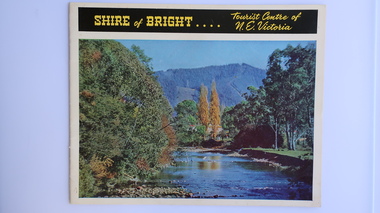
Brochure - Shire of Bright, Shire of Bright Tourist Centre of N.E. Victoria, Pre 1966
Bright and the surrounding towns were developing a large tourism industry which the Shire of Bright continues to promote, encouraging tourists to visit throughout the year. This high quality brochure has magnificent photos with a map showing the area and the distance (in miles) from the centre - the township of Bright.This brochure is promoting the Shire of Bright encouraging tourism in the area. This is important for the Shire as tourism is the main industry for the Shire. It is interesting to see how tourism has changed (or not) in the area.14 pages on glossy paper including colored and black and white photos. The front cover has the title at the top with yellow print on black background. Below the title is a large colored photo of a river, autumn trees and mountain. The back cover is a large colored photo of a man amongst the snow gums in the snow. The towns covered are Bright, Wandiligong, Eurobin, Mt Buffalo, McKay Creek Power Station, The Kiewa Hydro Electric Scheme, Mt Beauty, Kiewa, Bogong including tourist destinations in these areas and their surrounds.tourism; mt beauty; the kiewa valley; bright shire -
 Melbourne Tram Museum
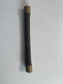
Memorabilia - Sample of worn cable tram rope
Section of worn cable tram wire rope. One of the two ferrules has been engraved with "243 Weeks 341591 Miles" and the other "ANTD 12 Weeks" - "ANTD" is thought to be an abbreviation for anticipated. On this basis, the cable rope lasted 20 times its expected life! Demonstrates a worn cable tram wire rope that has been sampled and its use recorded.Section of worn Melbourne cable tram wire rope with engraved retaining brass ferrules on each end consisting of seven wound (12 wires) around a central fibre core.See contexttramways, cable trams, cable ropes, cables, mmtb -
 Ringwood and District Historical Society
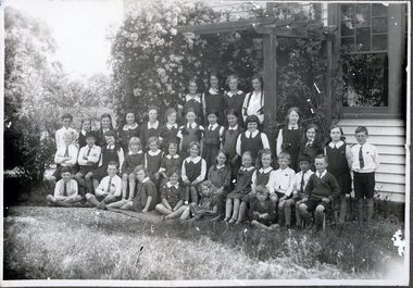
Photograph - Black and White, Winnington Grammar School, Ringwood, Class Photo, 1931 Term 3
B&W Class photo in front of Winngton Grammar School, 35 Ringwood St, Ringwood. Handwritten on reverse: 1931, term 3. Back Row: Helen Newell, Joyce Covell, June Miles, Majorie Palmer 2nd Row: Doug? Lucas, ? , Frances Gowland, ? , Leila Bielby, Margaret Barrett, Pat Court, Mary Cheong, Meriel Wilmont, Phyllis Prior, Margaret Douglas, ? , Phyllis Holder, John Covell 3rd Row: Keith Hewitt, ?Gordon?, Peter Cheong, ? , Pat Hewitt, ? , Meryl Lucas, Nancy Newell, ? , Winsome, ? , Jack Nethercote, Gordon?, Peter? Cheong, Jack Miles Front Row: ? , Cliff Bielby, Joan Court, ? , Dorothy Nethercote, ? -
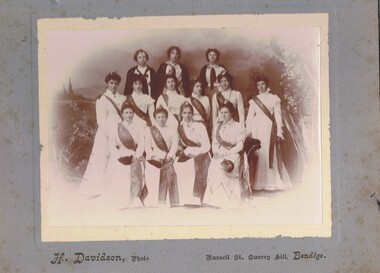 Bendigo Historical Society Inc.
Photograph - GROUP OF WOMEN, EMPIRE DAY DRESS, 1910?
Sepia photograph on grey board. Ten females in long white dresses with long fringed sashes embossed with 'cead mile failte'. All have small Irish harps in hair and carry small black bags. Back row - three young girls with white tops and dark capes. Inscriptions: in image - on sashes 'cead mille failte'. Printed on board at bottom 'H Davidson, Photo, Russell Street, Quarry Hill, Bendigo'. On back - hand written in pencil. 'Empire Fair', 'Ireland', 'Mechanic's Institute'.H Davidson, Russell Street, Quarry Hillperson, group, women -
 Bendigo Historical Society Inc.
Document - SOUTH NEW MOON GARDEN GULLY LINE OF REEF
Two page typed carbon copy of document, headed 'South New Moon, Garden Gully line of Reef', located one mile north from Eaglehawk post Office. An historical overview of the mine is provided with information regarding its location, depth of shaft, original company, engine house, air compressor, battery and years of operation. The steel poppet legs were approximately 85 ft high and had a greater slope than usual on the front legs. ' Said to be the best poppet legs on the field'.Albert Richardsonbendigo, mining, south new moon mine -
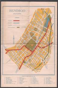 Bendigo Historical Society Inc.
Map - BILL ASHMAN COLLECTION: MAP OF BENDIGO
Map of Bendigo. Contains street of Bendigo with Places of Interest marked, Map of the Bendigo Area with Places of Interest marked, and on the centre page is Bendigo the Golden Gateway to the North. There is a map with circles around Bendigo and their distance from centre Bendigo. Circles go to a distance of 20 miles. Information includes General Information, Scenic Attractions, Industrial Activities, Industries already Established, Sporting Facilities - Bendigo and District, and Cultural Organizations. JCI shield on the left under the map. Also some brief information about Bendigo.sciences, instruments - general, scalebuoy, bill ashman collection - correspondence, map of bendigo, cambridge press, a r mcconnachie, bendigo junior chamber of commerce, bendigo city council -
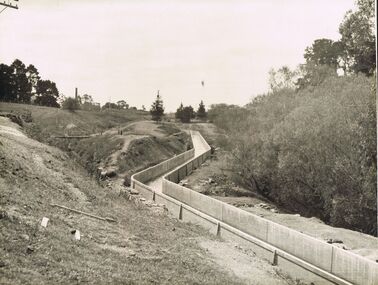 Bendigo Historical Society Inc.
Photograph - JOSEPH BRADY COLLECTION: FLUMING BETWEEN MALMSBURY RESERVOIR AND CALDER HIGHWAY, 1934
Black and white photograph: image shows concrete channel snaking down hill, top LH side appears to be bluestone mill with tall chimney. Trees on RH side of channel. Comments on the back of the photo 'Between Malmsbury Res and Calder Hwy. 8 feet wide 4 foot 6 inches deep. Taken 1934. JA 10/81 concrete grand fluming at 12.5 miles Main channel 8 feet wide 4 foot 6 inches high. Constructed 1928.'place, water, coliban race, john brady collection. coliban race -
 Ballarat Tramway Museum
Photograph - Black & White Photograph/s, The Courier Ballarat, 4/4/1960?
Yields information about the appearance of the tramway and other vehicular traffic in Ballarat in 1060 and was used to illustrate a proposal to rename the street.Black and White photograph of Ballarat No. 38 at the Eastern end of Sturt St West, following proposal to name that section the "Royal Mile". Photo published by The Courier 5/4/1960. Has the outbound tram standing while the front door is open with the driver looking back. Note the lack of motor vehicles (cars) in the street. Collected by Alan Bradley from the Ballarat Courier early 1980's. See Excel file "Record of Ballarat Courier Photos SEC era" (Archive Documents) for source of details.On rear stamped "Copyright, The Ballarat Courier Proprietary Limited." and "91 ARPT" in ink.tramways, trams, sturt st west, royal mile, tram 38