Showing 3155 items matching "south west"
-
 Parks Victoria - Wilsons Promontory Lightstation
Box
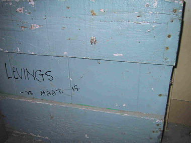
... they moved to Maatsukyer Island off south-west Tasmania, Australia’s... to Maatsukyer Island off south-west Tasmania, Australia’s southern-most ...The grey painted heavy wooden, homemade box has a freehand inscription in black on outside, which reads ‘LEVINGS To MAAT IS’. The writing refers to Alan and Marlene Levings, who began their twenty-two year career in lightkeeping with a posting to Tasman Island, off Port Arthur, in the 1960s. After four years they moved to Maatsukyer Island off south-west Tasmania, Australia’s southern-most lightstation, followed by postings to South Bruny, Eddystone Point and Wilsons Promontory. The robust box journeyed with the Levings through their postings to five lightstations and came to rest at Wilsons Promontory when Alan retired. It is not known whether the box was used in an office or domestic context. The movement of people and objects is a significant and unique theme that runs through the history of Australia’s lightstations. This historical process relates Victoria to the much bigger story of Australia’s network of lightstations. Alan Levings has been described as an extremely interesting character and artist. When Levings was a lightkeeper at Wilson’s Promontory, delivery of goods was by boat, then off the boat by a winch and onto the back of a truck. For this reason, packing boxes in earlier years had to be extremely robust. Today, anything that is not carried into Wilson’s Promontory Lightstation by foot, comes by helicopter, eradicating the need for heavy packing boxes such as Levings’. This humble box has first level contributory significance for its reliable provenance which traces its journey through five lightstations; for its association with a former lightkeeping family; and for contributing to an understanding of the pattern of lightstation life.Wooden box, light blue/grey painted. Made of horizontal pieces of timber with some tin reinforcment on the sides. Writing in black on side of box.On side of box in freehand,"LEVINGS To MAAT IS" -
 Melbourne Tram Museum
Photograph - Digital Image, Kevin O'Reilly, series of three images of the Hawthorn Bridge over the Yarra, c1930, c1930's
... from the south west, at the Hawthorn bridge with the temporary... from the south west, at the Hawthorn bridge with the temporary ...Image from CD (Compact Diskette for use in computers) - see Reg Item 135. A series of three images of the Hawthorn Bridge over the Yarra, c1930, during the era with problems with the bridge. See separate article for more details. Richmond 6, Richmond, Richmond 3 on the CD as original files. .1 - Looking from the south west, at the Hawthorn bridge with the temporary wooden bridge being constructed on the south side. Has the cable tram depot in the photo and part of the Burnley racing course. Temporary track on the north side of the steel bridge and crossings can be seen. .2 - Looking along Bridge Road to the east with Hawthorn Bridge in the middle of the photograph. Shows the industrial and residential areas, Hawthorn Railway Station and part of the Burnley Race course, the cable tram depot building. W class tram in Church St Hawthorn and W class tram crossing the bridge on the north side temporary track. Note the cable tram used as a shelter on the north east corner of the bridge. .3 - Looking south along River St towards Bridge Road, with the Yarra River and Hawthorn Bridge on the left side of the photograph. Shows the industry in the area at the time, wool and skin Merchants, north side of the cable depot, housing and the outlook to the river!trams, tramways, hawthorn, yarra river, burnley, richmond, hawthorn bridge -
 The Beechworth Burke Museum
Audio - Oral History, Jennifer Williams, Mr Alfred Spencer, 17th February 2000
... mother, west south west of Beechworth 'down Robertson Road... mother, west south west of Beechworth 'down Robertson Road ...Alfred 'Alf' Spencer grew up on a dairy farm run by his mother, west south west of Beechworth 'down Robertson Road', and was very well connected to the wider Beechworth area. In this oral history, he recalls his time driving the milk cart around Beechworth as well as the time he spent buying lollies and seeing the pictures. He talks extensively about working as a butcher at his brother's store, including how the butchers interacted with the rest of the town and the staff, as well as his time constructing roads and the pipe network of Beechworth. He discusses the dynamics of other workplaces around Beechworth, describing issues with how the local tannery treated its workers as well as how post-war migrants integrated across the town. He briefly discusses racial tensions between Chinese migrants and other miners on the goldfields. He also discusses the experience of health care in a rural area during his childhood. This oral history recording was part of a project conducted by Jennifer Williams in the year 2000 to capture the everyday life and struggles in Beechworth during the twentieth century. This project involved recording seventy oral histories on cassette tapes of local Beechworth residents which were then published in a book titled: Listen to what they say: voices of twentieth century Beechworth. These cassette tapes were digitised in July 2021 with funds made available by the Friends of the Burke.Alfred Spencer's oral history of his life around Beechworth during the 20th century is historically and socially significant to the cultural history of the region and Victoria. There is a lot of detail about workplaces, their staff, and how the resources of the town interacted. He explores themes that are important to Victorian history, such as migration. This oral history account is socially and historically significant as it is a part of a broader collection of interviews conducted by Jennifer Williams which were published in the book 'Listen to what they say: voices of twentieth-century Beechworth.' While the township of Beechworth is known for its history as a gold rush town, these accounts provide a unique insight into the day-to-day life of the town's residents during the 20th century, many of which will have now been lost if they had not been preserved.This is a digital copy of a recording that was originally captured on a cassette tape. The cassette tape is black with a horizontal white strip and is currently stored in a clear flat plastic rectangular container. It holds up to 40 minutes of recordings on each side.Mr Alfred Spencer /listen to what they say, beechworth, oral history, burke museum, spencer, alfred spencer, migration, post-war migration, goldfields, health care, farm, farming, dairy farm, black springs, butchers, meat processing, butcher, road, road network, labour relations -
 Victoria Police Museum
Police Stations (Altona)
... Altona is a suburb of Melbourne, 13 km south-west... melbourne Altona is a suburb of Melbourne, 13 km south-west ...Altona is a suburb of Melbourne, 13 km south-west of Melbourne's CBD and located within the City of Hobsons Bay Altona Police Station opened as a temporary police station in 1919 in the Melbourne District. It was on the corner Sargood and Blyth Streets. It was staffed by one 1st Constable. The original police station was in a small room attached to the front of a 5-roomed weather-board dwelling with an iron roof on land measuring 66' x 165'. There was also a kitchen, vestibule, wash-house, office, one W.C. and a lock-up. In 1929 it became part of the Bourke District. On 31 March 1958 it moved into newly built government premises at 51-53 Blyth Street, on the corner of Bent Street. The building consisted of a cream brick veneer police residence and police station with cell. Staff was increased to a Sergeant in Charge and 3 Constables. A new police station was opened in Altona North on 7th October 1979. The Altona Police Station remained as a sub-station for a few a short time until the building was sold. July 2019 - a new police station is being constructed at 1 Galvin Street, Altona. Galvin Street was names after S/C Michael Arthur Galvin, 3651, who was appointed on 5 Jan 1886 and resigned on 4 Dec 1913. He was Werribee Shire President 1926-1927 and 1940-1941 8 black and white photos of new police station, 1963police stations; altona police station -
 Ballarat Heritage Services
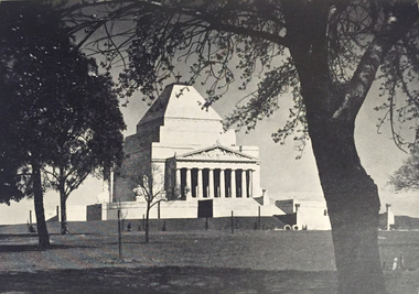
Photograph - Image, Shrine of Remembrance, Melbourne, c1934, 1934
... to Mausolus, King of Caria in South West Asia Minor. Although...—the mausoleum at Halicarnassus to Mausolus, King of Caria in South West ...The design for the Shrine of Remembrance was selected by competition among Australian artists and architects. Eighty-three designs were submitted and the winning design was by two Melbourne returned-soldier architects, Philip Hudson and James Wardrop. The inspiration for the external outline came from one of the seven wonders of the ancient world—the mausoleum at Halicarnassus to Mausolus, King of Caria in South West Asia Minor. Although the country was faced with frightful unemployment and financial difficulty in the late 1920s and the 1930s, so great was the gratitude of the people that the huge amount required to build the Shrine was raised or promised within six months from the opening of the appeal in 1928. (https://www.shrine.org.au/About-Us/History) Lodge Bros were commissioned to build the Shrine of Remembrance in St Kilda Rd in the late 1920s. In 1947, Lodge Bros were manufacturing a further stage at the Shrine of Rememberance, that being the carving and fixing of the bluestone servicemen on the top of the 1939-1945 War Memorial at the Eternal Flame. When funding became available for the new undercroft development at the front of the Shrine in 2001, the Shrine Trustees were eager to explore the possibility of the original stonemasons who built the Shrine, to complete the new development. This came to fruition in 2002-2003 when Lodge Bros constructed all the exterior walls of the undercroft development. Phil Luchetta (Managing Director) was able to source and secure the use of the same granite from Tynong Victoria that was used in the original works of the 1930s.Photograpic image of Melbourne's Shrine of Remembrance.shrine of remembrance, melbourne, war memorial, lodge brothers, world war one, remembrance -
 Flagstaff Hill Maritime Museum and Village
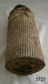
Weapon - Ammunition Shell, late 19th-early 20th century
... of South West TAFE). The 40lb Armstrong Guns were recalled back... of South West TAFE). The 40lb Armstrong Guns were recalled back ...Ammunition shell was used in a 40 lb Armstrong Rifled Breach Loading (RBL) Gun. The shell was fired into Westernport Bay by the Hastings Battery Field Artillery in late 1800’s or early 1900’s. It was recovered by divers in recent times. It does not contain explosives because the projectile and explosive were separate items. The Armstrong 40 lb BL Gun There were 4 x 40lb Armstrong (RBL) Guns issued to the Ham and Beef Battery at Hastings Victoria. After the Hastings Battery field artillery disbanded, the 4 Guns were transferred from the Hastings Battery to the Warrnambool Battery field artillery in 1904. (There is a photograph of one of these guns on its carriage, pictured in front of the Orderly room (Drill Hall) at Warrnambool, which is now the Library of South West TAFE). The 40lb Armstrong Guns were recalled back to Melbourne when the government issued the updated 4.7inch QF (Quick Firing) Naval Guns, mounted on carriages, to the Warrnambool Garrison Artillery 1907. The Hastings Museum today holds one of the original 40lb Armstrong RBL guns that were at first at Hastings and then Warrnambool, evidenced by tracing the numbers on that gun. This gun has now been restored. Surviving 40 lb Armstrong BL Guns in Australia The Hastings Museum has restored one of the Guns that was at Hastings and then from 1904-1907 in Warrnambool. This Gun is now on display at the Hastings Museum. This ammunition shell from a 40lb Armstrong RBL gun is very significant because of its association with the Warrnambool Battery Field Artillery in the early 1904-1907. It is known that the original 40lb Armstrong RBL gun used in Warrnambool is now restored and on display at the Hastings Museum. Ammunition shell from a 40Ib Armstrong Rifled Breach loading (RBL) Gun. Metal bullet-shaped object, flat base, tapering to cone-shaped tip. Parallel equidistant ridges run from outer edge of base to position where cone shape begins. Tip has a square-shaped hole in the centre and has a very uneven surface. Base has corrosion and metal is flaking away. Does not contain explosives. Remnants of white paint-like substance in several places. From the Hastings, Victoria, area. Late 19th - early 20th century.flagstaff hill, warrnambool, shipwrecked coast, flagstaff hill maritime museum, maritime museum, shipwreck coast, flagstaff hill maritime village, great ocean road, ammunition shell, 40 lb armstrong rbl gun, volunteer corps, war equipment, defence forces, warrnambool bettery field artillery, hastings battery field artillery, defence of warrnambool -
 Bacchus Marsh & District Historical Society
Photograph, Woolpack Stables Bacchus Marsh 1883
... cleared yard. There is a skillion extension to the south-west... cleared yard. There is a skillion extension to the south-west ...This image is one of a series of photographs taken by Melbourne based photographers Stevenson and McNicoll who visited Bacchus Marsh and its nearby districts between September and November 1883. James Elijah Crook settled in Bacchus Marsh in 1841 and soon after held a licence for a lodging house on the Portland Road. In about 1845, he built the first Woolpack Inn, a slab building of eight rooms. This was replaced in 1850 with a “stately country villa” of brick and stone. The stables were also built in 1850 to accommodate twenty horses. In 1851, Crook established a coach service to the goldfields. After being in use as a Court of Petty Sessions, the Woolpack Inn lost its licence and closed in 1862. After this date, Crook took an interest in horse-breeding and continued to use the stables for his horses. His most notable success was with his horse, Saladin, which won the Australia Cup in 1872, after two exciting dead-heats with The Flying Dutchman. James Elijah Crook died in 1889. The Woolpack Inn and Stables were sold and then used as a hay and corn store. In 1910 the site was leased for use as an abattoir. The Woolpack Inn was demolished in 1931. The site is still in use as an abattoir. Little remains of the original stables.Small sepia 'carte de viste' style unframed photograph on card with gold border framing photograph. Housed in the Jeremeas Family Album which contains photographs of Bacchus Marsh and District in 1883 by the photographers Stevenson and McNicoll. The photo is of a gable-roofed commercial stables with shingled roofing, and white-washed render to the walls, standing in a large cleared yard. There is a skillion extension to the south-west corner. On the front (northern) wall can be seen a door and three windows, two large and one small paned window in the centre. The eastern window is paned, while the western window has louvres and a pull-out blind. Three S shaped stays can be seen on the northern wall. Along the western wall are two more windows and doors. A mound of hay lies at the north-western corner. Standing at the front of the stables is a group of five men and two boys, one holding a large dog. Four of the men are dressed in workman’s clothing and some are holding tools of their trade. The man at the back is wearing more formal clothes and has distanced himself from the workmen. The pole against which one of the workmen is leaning appears to have damage along one side. This pole may have been used as a hitching post as there is a footrest installed lower down to make mounting easier. Printed On the front: Stevenson & McNicoll. Photo. 108 Elizabeth St. Melbourne. COPIES CAN BE OBTAINED AT ANY TIME. On the back: LIGHT & TRUTH inscribed on a banner surmounted by a representation of the rising sun. Copies of this Portrait can be had at any time by sending the Name and Post Office Money Order or Stamps for the amount of order to STEVENSON & McNICOLL LATE BENSON & STEVENSON, Photographers. 108 Elizabeth Street, MELBOURNE. stevenson and mcnicoll 1883 photographs of bacchus marsh and district -
 Federation University Historical Collection
Image - black and white, Barwon River Man (New South Wales)
... Empire: Victoria' The Barwon River in New South Wales is formed... of Queensland. The Barwon River generally flows south and west, joined ...Digitised directly from 'The Native Races of the British Empire: Victoria' The Barwon River in New South Wales is formed through the confluence of the Macintyre River and Weir River (part of the Border Rivers system), north of Mungindi, in the Southern Downs region of Queensland. The Barwon River generally flows south and west, joined by 36 tributaries, including major inflows from the Boomi, Moonie, Gwydir, Mehi, Namoi, Macquarie, Bokhara and Bogan rivers. During major flooding, overflow from the Narran Lakes and the Narran River also flows into the Barwon. The confluence of the Barwon and Culgoa rivers, between Brewarrina and Bourke, marks the start of the Darling River.Black and white Image of an Aboriginal man from Barwon River, New South Wales. Aboriginal people from six language groups originally occupied the area of the Barwon River wetlands. These were the Ngemba, the Baranbinja, the Murrawari, the Ualayai, the Weilwan, and the Kamilaroi peoples. The Aboriginal people generally used the wetlands for hunting, fishing, and gathering uses, and for cultural association.(Wikipedia) The name "barwon" is derived from the Australian Aboriginal words of barwum or bawon, meaning great, wide, awful river of muddy water; and also baawan, a Ngiyambaa name for both the Barwon and Darling rivers. The history, culture and livelihoods of the local Aboriginal people are closely intertwined with the Barwon River and its associated tributaries and downstream flows. (Wikipedia)aborigine, aboriginal, barwon river -
 Melbourne Tram Museum
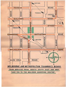
Poster, Melbourne & Metropolitan Tramways Board (MMTB), Malvern Shopping Centre, 1950's?
... - Tram services from North South East and West take you... South East and West take you to the Malvern Shopping Centre ...Poster titled "Melbourne and Metropolitan Tramways Board - Tram services from North South East and West take you to the Malvern Shopping Centre" Prepared on a Dyeline drawing base and then hand coloured using a draftsman's wash in red for tram lines and green for the shopping centre. Shows the various main roads, tram lines, and rail lines. Has a compass drawn on it. No date - presumed 1950'sctrams, tramways, malvern, glenferrie rd, shoppers -
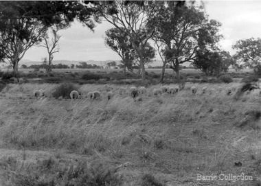 Melton City Libraries
Photograph, Ferris Road Landscape, Unknown
... Barrie House on Ferris Road was located on the west side... Barrie House on Ferris Road was located on the west side south ...Barrie House on Ferris Road was located on the west side south of Highway. Weather board house was moved from Harkness Rd in 1941 and was moved to Bulmans Road near Porteous Road 1988/90 The site was near the entrance to the Harness Racing Complex.Black and white photos of the Ferris Road landscapeagriculture -
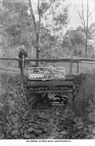 Eltham District Historical Society Inc
Photograph, The Rose Stereograph Company, Log Bridge, Eltham Road. Greensborough, c.1920
... from south west to the north east, possibly feeding... from south west to the north east, possibly feeding ...A woman stands at the end of a log bridge over a creek looking towards the south along the unsealed roadway. The sun illuminates her back. She is wearing a woollen knit beanie with edges rolled up, dark jacket and skirt, full length dark stockings and slip on dark leather shoes with raised heel, typical of the early 1920s. The creek is possibly feeding into the Karingal Yalloc. The direction of the road based on shadows is northwest as is the Eltham Road to Greensborough (present day Sherbourne, Karingal and St Helena roads). The creek is falling to the foreground so from south west to the north east, possibly feeding into the Karingal Yalloc, somewhere near presenet day Ramptons Road Reserve. This glass plate negative was used to manufacture postcards (1:1 printing) for commercial sale by the Rose Sterograph Company and its subsidiaries. George Rose founded the Rose Stereograph Company in 1880 and was joined by Herbert (Bert) Cutts in the early 20th Century. The pair formed a lifetime working partnership and strong personal friendship. Assisted by George’s two sons, Herbert George and Walter, and later by Neil Cutts, the Rose Stereograph Company continued its operations for more than 140 years. The company was initially built on stereographs, but as cinema took over and stereographs fell out of fashion, the Rose Stereograph Company developed Australia’s first commercially viable photographic postcard business. Specialising in postcards of iconic historical moments and significant landmarks, The Rose Stereograph Company became a staple of the Australian travel industry.This remarkable collection of glass plate negatives, transparencies, and postcards – arguably Australia’s most significant photography collection outside of public hands – has been passed down through the generations, surviving war, relocation, and the harsh Victorian climate. The historic Rose Stereograph collection is the culmination of George Rose’s dream of capturing and preserving precious moments in time and remains the legacy of the Rose and Cutts families. It is with great sadness that the Cutts family says goodbye to a collection that spans five generations and 140 years. The Cutts family understands that for these historically important pieces to rest with one family is to deny others the pleasure of their custodianship.Glass Plate Negative Size: 9.2 x 13.8 cmLog Bridge, Eltham Road, Greensborougheltham, postcard, travel, rose stereograph company, glass plate negative, creek, eltham road, greensborough, karingal road, karingal yallock, log bridge, sherbourne road, st helena road, women's fashion, rampton's road reserve, peter and elizabeth pidgeon collection -
 Flagstaff Hill Maritime Museum and Village
Equipment - Rocket Launcher, Government of Victoria, ca 1910s
... . The coastline of South West Victoria is the site of over 600 shipwrecks... ear of the 1910s. The coastline of South West Victoria ...This rocket launcher has fittings to mount it onto a lifeboat or similar vessel. Once mounted, a it would be fitted with a line-throwing rocket that would be launched from the vessel and aimed over the shipwreck. The line would be fixed to the ship in distress. A heavier line would then be sent out to the wrecked vessel and survivors would be hauled to safety. Its design suggests that it dates to the First World War ear of the 1910s. The coastline of South West Victoria is the site of over 600 shipwrecks and many lost lives; even in Warrnambool’s Lady Bay there were around 16 known shipwrecks between 1850 and 1905, with eight lives lost. Victoria’s Government responded to the need for lifesaving equipment and, in 1858, the provision of rocket and mortar apparatus was approved for the lifeboat stations. In 1859 the first Government-built lifeboat arrived at Warrnambool Harbour and a shed was soon built for it on the Tramway Jetty, followed by a rocket house in 1864 to safely store the rocket rescue equipment. In 1878 the buildings were moved to the Breakwater (constructed from 1874-1890), and in 1910 the new Lifeboat Warrnambool arrived with its ‘self-righting’ design. For almost a hundred years the lifesaving and rescue crews, mostly local volunteers, trained regularly to rehearse and maintain their rescue skills. They were summoned when needed by alarms, gunshots, ringing bells and foghorns. In July 1873 a brass bell was erected at Flagstaff Hill specifically to call the rescue crew upon news of a shipwreck. Some crew members became local heroes but all served an important role. Rocket apparatus was used as recently as the 1950s. This item is significant for its connection with maritime history and marine technology. Lifesaving has been an important part of the services performed coastal Victoria, including Warrnambool, in its very early days, supported by State and Local Government, and based on the methods and experience of Great Britain. Hundreds of shipwrecks along the coast are evidence of the rough weather and rugged coastline. Ordinary citizens, the Harbour employees, and the volunteer boat and rescue crew, saved lives in adverse circumstances. Some were recognised as heroes, others went unrecognised.Rocket launcher, lifesaving equipment, attaches to rail on vessel. Schermuly's Patent, Grey metal, L shaped pipe with large clamp on one end and small, hooked U shaped fitting on the other. Connects to half-cylinder sleeve with gimbal fitting, ball joint and adjusting fittings; painted grey and red. "SCHERMULY'S PATENT" cast into clamp.Cast into metal "SCHERMULY'S PATENT" flagstaff hill, flagstaff hill maritime museum and village, warrnambool, maritime museum, maritime village, great ocean road, shipwreck coast, rocket launcher, rocket apparatus, rocket firing equipment, lifesaving equipment, wwi, world war i, 1210s, schermuly’s patent, schermuly launcher, sea rescue, lifesaving, shipwreck, life-saving, rescue crew, rocket rescue, rocket crew, line rescue, maritime activities, marine technology, volunteer crew, boat to ship rescue, william schermuly, -
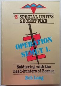 Australian Commando Association - Victoria
Book, Z Special Units' Secret War- Operations SEMUT 1, 1989
... of 81 covert operations in the South West Pacific theatre... of 81 covert operations in the South West Pacific theatre ...An account of the operations of The Allied Intelligence Bureau (AIB) better known as ‘Z’ Special Unit. Now a scarce and highly sought after title. The author’s personal experiences with Australian Special Forces (Services Reconnaissance Department) which involved guerrilla soldiering with the head-hunters of Japanese held Borneo during World War 2. Z Special Unit an administrative support unit of (also known as Special Operations Australia (SOA) or the Services Reconnaissance Department (SRD)) was a joint Allied special forces unit formed during the Second World War to operate behind Japanese lines in South East Asia. Predominantly Australian, SRD was a specialist reconnaissance and sabotage unit that included British, Dutch, New Zealand, Timorese and Indonesian members, predominantly operating on Borneo and the islands of the former Netherlands East Indies. The unit carried out a total of 81 covert operations in the South West Pacific theatre, with parties inserted by parachute or submarine to provide intelligence and conduct guerrilla warfare. The best known of these missions were Operation Jaywick and Operation RIMAU, both of which involved raids on Japanese shipping in Singapore Harbour; the latter of which resulted in the deaths of twenty-three commandos either in action or by execution after capture. Although the unit was disbanded after the war, many of the training techniques and operational procedures employed were later used during the formation of other Australian Army special forces units and they remain a model for guerrilla operations to this day.Hard Cover with Dust Jacket – 608 pagesInscribed by author-Bob Long AK223 SEMUT 1 Borneo 1945 -
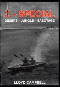 Australian Commando Association - Victoria
Book, Z Special- Desert-Jungle- Sabotage
... of 81 covert operations in the South West Pacific theatre... of 81 covert operations in the South West Pacific theatre ...When Lloyd Campbell joined the AIF, he was underage and went to the Middle East with 2/17 Battalion. Later in New Guinea he made a major career change and volunteered for an unknown unit and special operations. What he had joined was the SRD – known as Z-Special Unit. Z Special Unit—also known as Special Operations Executive (SOE), Special Operations Australia (SOA) or the Services Reconnaissance Department (SRD)—was a joint Allied special forces unit formed during the Second World War to operate behind Japanese lines in South East Asia. Predominantly Australian, Z Special Unit was a specialist reconnaissance and sabotage unit that included British, Dutch, New Zealand, Timorese and Indonesian members, predominantly operating on Borneo and the islands of the former Netherlands East Indies. The unit carried out a total of 81 covert operations in the South West Pacific theatre, with parties inserted by parachute or submarine to provide intelligence and conduct guerrilla warfare. The best known of these missions were Operation Jaywick and Operation Rimau, both of which involved raids on Japanese shipping in Singapore Harbour; the latter of which resulted in the deaths of 23 commandos either in action or by execution after capture. Although the unit was disbanded after the war, many of the training techniques and operational procedures employed were later used during the formation of other Australian Army special forces units and they remain a model for guerrilla operations to this day. pp. 274, illusts, maps ww2, the australian special operations, special forces, z special unit -
 Uniting Church Archives - Synod of Victoria
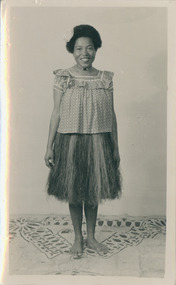
Photograph, Katalini Dimula, 1952
... '. Katalini. whose home is on the Island of Misima, in the far south...'. Katalini. whose home is on the Island of Misima, in the far south ...From the Adelaide Advertiser for 19 November 1952, p. 11: Two Happy Visitorsf rom the Pacific Adelaide is proving 'just like our real home'' to two charming and interesting visitors from Methodist missions in the Pacific. Miss Ravesi Mosi. of Fiii. and diminutive Miss Katalini Dimula, of Papua, the first native women missionaries to visit Australia From these islands. Ravesi and Katalini have enjoyed vastly the three months they have already spent in this country. Thev came here at the' invitation of the Methodist Women's Auxiliary for Oversea Missions in Victoria to take part in their diamond jubilee celebrations in Melbourne. They also spent some time in Sydney. But they are particularly happy to be in Adelaide because both of them have found old and good friends here. That is why it feels! like 'home'. Katalini. whose home is on the Island of Misima, in the far south-west of Papua, is the guest of the Rev. H. K. Bartlett and Mrs Bartlett. who lived on Misima for several years and knew Katoitni as a young girl. They are the first people she has met in Australia who speak her language and know her background. It was a personal interest to them to hear of her work as a missionary nurse, for which she did her training in Salamo Hospital on Ferguson Island, about 200 miles away from Misima, where she now helps to train the women of the island villages in the principles of health and hygiene and caring for their babies according to modern methods.Katalini is dressed in a grass skirt and a western top."Katalini Dimula" "D. Schmidt"katalini, dimula, methodist, papua -
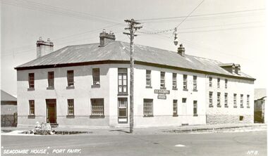 Port Fairy Historical Society Museum and Archives
Postcard - Photograph, Seacombe House Port Fairy
... Inn to John Taylor he acquired the land on the South west..., on the site of the present day Star of the West hotel. After selling ...Seacombe House Formerly named The Stag Cnr Sackville and Cox Streets Port Fairy John Sanders (Saunders) first came to Port Fairy in charge of the "Sally Ann" owned by the Henty family of Portland. He left the sea behind in 1844 and established the "Sally Ann Inn" named for his old ship, on the site of the present day Star of the West hotel. After selling the Sally Ann Inn to John Taylor he acquired the land on the South west corner of Sackville Street and erected a detached cottage facing Sackville Street for which he obtained a licence to sell alcohol and named the premises The Stag Inn. He died in 1850 and his wife leased the Inn to John Mason. By 1852 a large two story rendered bluestone building had been constructed on the corner site. The second un rendered section was probably added in 1854. Abijah John Brown became licencee in 1855 and made the Stag the centre of entertainment for the district, with many balls, dinners and concerts taking place there. It boasted "a billiard room and a twenty stall stables and coach house". By 1861 Abijah Brown had left The Stag and Lennox Trew was now owner and licencee. It came up for sale in 1869 but failed to sell. After Trew's death in 1886 it was sold to a syndicate and opened as a boarding school. It later became a Coffee Palace and Accomodation house named Seacombe House, and in the 1950's a motel was built on the old stable site. It is still a Hotel Motel and a restaurant which has revived the old name of "The Stag". Black and white Photograph of 2 story rendered building with multi paned windows and power pole on cornerhotel, lennox trew, abijah brown, john sanders, john saunders, john mason., sackville street, cox street, stag inn, stag hotel, seacombe house, coffee palace -
 Bendigo Historical Society Inc.
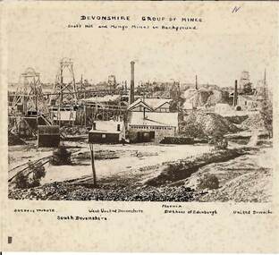
Photograph - DEVONSHIRE GROUP OF MINES,1896
... Tribute', 'South Devonshire', 'West United Devonshire', 'Pheonix... Tribute', 'South Devonshire', 'West United Devonshire', 'Pheonix ...Black and white photograph on cream card.Foxing spots throughout. Date approx. 1896 / 1876. View across mining area showing at least 9 poppet heads, 11 chimneys and many buildings associated with the mines. C to L - flume, wood stacks, mullock heaps. Inscriptions in image: 'Duchess Tribute' on weather board building at C. 'N' at TR. Hand printed above image (on earlieir copy of this image of which this is a photograph), 'Devonshire Group on Mines / Snob's Hill and Mungo Mines in Background'. Above image: 'Duchess Tribute', 'South Devonshire', 'West United Devonshire', 'Pheonix', 'Duchess of Edinburgh', 'United Devonshire'. On the back: blue circular stamp 'Royal Historical Society of Victoria, Bendigo Branch' , 'MNG 71'.James Lerk 26/11/1999place, mining site, see also 2000.426.01, 2000.437.01, 2000.438.01, 2000.439.01, 2000.504.01, 2000.508.01, 2000.509.01 -
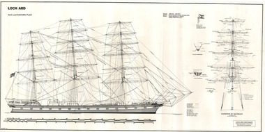 Flagstaff Hill Maritime Museum and Village
Document - Ship Model Plans, Loch Ard, October 1977
... of the tragic LOCH ARD shipwreck on Victoria’s south west coast in 1878... of the tragic LOCH ARD shipwreck on Victoria’s south west coast in 1878 ...These two framed model ship plans are from more than 650 produced for the LOCH ARD Centenary (1878-1978) Commemoration Committee. These plans were originally researched, designed and distributed in 1977 to assist entrants in the Committee’s Ship Model Competition. The competition was arranged as a means of creating public interest and awareness for the 100th anniversary of the tragic LOCH ARD shipwreck on Victoria’s south west coast in 1878. The main subject specified for modelling was “The Loch Ard ― Iron Wool Clipper 1873”. “The plans were drawn by Mr P Webb to the order of the Committee through Mr P Williams, organizer of the competition. The details were based on all available information which resulted in considerable historical research…and received favourable comment from model makers because of their attention to detail…In excess of 650 sets of plans were sold before entries closed…Many plans were probably purchased by collectors and interested persons for historical reference. An illustrated historical story sheet…was prepared and enclosed with the plans…” (‘Loch Ard Shipwreck Centenary 1878-1978 Report’, November 1978). An example of the attention to historical detail delivered on the plans is the inclusion of the following useful information about the original vessel: “Tonnage….1,693 G.R.T., 1,624 N.R.T. Builders….Charles Connell & Co., Ltd., Scotstoun, 1873. Owners….General Shipping Co., Glasgow, (Aitken Lilburn & Co., Ltd.)”. The quality of research and drafting makes these framed copies of considerable interpretive value to related items from the LOCH ARD shipwreck on display at Flagstaff Hill. They were originally mass produced but are now out of print. Flagstaff Hill retains other (unframed) copies in storage. The plans, in conjunction with the scale Ship Model of the LOCH ARD also on display, are of interpretive significance to Flagstaff Hill Maritime Village. The plans provide historical and technological context to artefacts from the shipwreck, increasing understanding and appreciation of those objects. Flagstaff Hill’s collection of artefacts from LOCH ARD is significant for being one of the largest collections of artefacts from this shipwreck in Victoria. It is significant for its association with the shipwreck, which is on the Victorian Heritage Register (VHR S417). The collection is significant because of the relationship between the objects, as together they have a high potential to interpret the story of the LOCH ARD. The LOCH ARD collection is archaeologically significant as the remains of a large international passenger and cargo ship. The LOCH ARD collection is historically significant for representing aspects of Victoria’s shipping history and its potential to interpret sub-theme 1.5 of Victoria’s Framework of Historical Themes (living with natural processes). The collection is also historically significant for its association with the LOCH ARD, which was one of the worst and best known shipwrecks in Victoria’s history. Two framed model ship plans of the LOCH ARD. These are detailed and researched plans from the original vessel, drawn to scale and printed on good quality paper, and framed behind glass to be hung on display. One slightly smaller plan “Lines, Decks and Details” portrays the hull lines as a body plan (straight on at the bow), a sheer plan (full side view), and a half breadth plan (a top-down view of deck to keel), as well as two top-down views of the upper decks and main deck with fittings and details of specific fixtures. One slightly larger “Sail and Rigging Plan” presents a side on, above deck view of masts and shrouds and a front on, above deck view showing “Elevation of Mainmast Looking Aft”. Each plan bears the draftsman’s initials and date of completion (“P.A.W. 10/77”). The larger plan also includes a boxed label attributing the project to the “LOCH ARD CENTENARY Commemoration Committee Ship Model Competition.”Smaller plan: heading “LOCH ARD: LINES, DECKS and DETAILS”; initials “P.A.W. 10/77”. Larger plan: heading “LOCH ARD: SAIL and RIGGING PLAN”; initials “P.A.W. 10/77”; label “LOCH ARD CENTENARY Commemorative Committee Ship Model Competition”. flagstaff hill, warrnambool, shipwrecked coast, flagstaff hill maritime museum, maritime museum, shipwreck coast, flagstaff hill maritime village, great ocean road, loch line, loch ard, captain gibbs, eva carmichael, tom pearce, glenample station, mutton bird island, loch ard gorge, ship model plans, loch ard model plans, sailing ship, loch ard centenary -
 Federation University Historical Collection
Plan, New Engineering Building for Ballarat School of Mines, 1939, 13/06/1939
... .1) West and South Elevations .2) East and North Elecation... architectural drawing .1) West and South Elevations .2) East and North ....1) West and South Elevations .2) East and North Elecation and floor plan .3) Sections E-F, M-N, O-P, G-H, Z (Excavations and retaining walls) .4) Site plan and details of Retaining Walls .5) Excavations and retaining walls .6) Site Plan and retaining walls chief architect, ballarat school of mines, saw-tooth, engineering, architectural drawing -
 Federation University Historical Collection
Photograph - Photographs - black and white, Ballarat School of Mines: Lydiard Street Campus Buildings, early 1900s, c1978
... spaces. .2: "Old Chemistry building" showing the south side... Street South SMB Campus .1: Art School opened in 1915 on the site ...These photographs were taken just before structural modifications and connecting overhead walkways were commenced in 1978.1: Art School opened in 1915 on the site of the original SMB building.It was converted from the abandoned court house. Also Administration building including the teaching and other spaces. .2: "Old Chemistry building" showing the south side and west end. .3: Art school on the left, Ballarat Brewery boiler chimney stack in centre background, Administration building on the right. .4: Entrance on the north side of Art School building .5: South side entrance of Administration building.ballarat school of mines, buildings, a building, administration building, lydiard street south, smb campus -
 Ballarat Tramway Museum
Photograph - Colour Photograph/s, Carolyn Dean, Apr. 1999
... and partially painted fence looking south west. .18 - ditto looking... and partially painted fence looking south west. .18 - ditto looking ...Set of 20 photographs taken by Carolyn Dean between 16/4/1999 and 16/5/1999 of moving the ex SEC bike shed to Bungaree and placing the roof back onto the shed and other works at Bungaree and one tram operation photo. On Kodak paper. 1095.1 - Loading the shed at Ballarat East - Alastair Reidier and Peter Winspur. .2 - ditto .3 - truck with shed on approach road to house. .4 - ditto and John Phillips .5 - lifting the shed into position at Bungaree over the power line. .6 - ditto .7 - lowering onto the foundations. .8 - tram 14 in Wendouree Parade near depot junction. .9 - Fixing hole in roof of the house - Bungaree - John Phillips .10 - ditto .11 - its snowing - Darren Hutchesson, Carolyn Dean, Alan Snowball - photo John Phillips .12 - putting roof back on the shed .13 - various cars out front of the house. .14 - nailing weather boards back on - Peter Winspur, Sftnon Jenkins, Alan Snowball .15 - ditto .14 used in the May 1999 Fares Please! .16 - fitting off purlins - Darren Hutchesson and John Phillips .17 - view of house and shed and partially painted fence looking south west. .18 - ditto looking south. .19 - fitting off the sheet metal - John Phillips .20 - cleaning up the tree in frost of the house from breaking off more branches - Alan Snowball and Alastair Reither. .1 > .7-16/4/1999: .8 - 25/4/1999: .9 > .16-15/5/1999: .17 > .20-16/5/1999. See also Reg. No. 1095 for next stage of the move.On rear of each photo in blue ink is date in the upper edge and on lower edge "Photo by Carolyn Dean"btm, sec bike shed, bungaree -
 Phillip Island and District Historical Society Inc.
Photographs, Fuji Film, 1950's - 1960's
... of a marching display at the West and South Gippsland Regional Band... at the end of a marching display at the West and South Gippsland ...Three of a collection of photographs donated by Bernie De La Haye.Three photographs of the Phillip Island Brass Band. 350-11: Colour photograph of the Band in the street at the end of a marching display at the West and South Gippsland Regional Band Competition at Leongatha or Korumburra? 350-12: Black & White photograph of the Band taken outdoors. 350-13: Colour photograph of the Band taken during a break during a concert in the 1950's.Names of members in 350-13: Bandsmen seated Left to Right: R De La Haye, R Cleeland, J Dixon, R Dixon, G Gliddon, P Forrest, A Towns, M De La Haye, J Gliddon, A Murdoch, W McLardy, B West, L Dixon, H De La Haye, N Cleeland. Bandsmen Standing Left to Right: E Booth, E May (Bandmaster), G Dunscombe, A Murray. Non Band Members, Left to Right: B Forrest, P Forrest jrn., S Papworth, M Toovey (being cheeky).phillip island brass band, phillip island municipal brass band, bernie de la haye -
 The Beechworth Burke Museum
Photograph - Photograph - Reproduction, ca. 1900
... This image shows the approach to Beechworth from the south...-country This image shows the approach to Beechworth from the south ...This image shows the approach to Beechworth from the south-west via the Newtown Bridge. Numerous early buildings line the road as it bifurcates to become Ford and High Streets on the ridge above Spring Creek and Newtown Falls. The sloping, rocky terrain and water course along the gorge show evidence of the intense mining activity that occurred at the site. The Ovens Gold Rush at Beechworth started when gold was found at Spring Creek in February 1852, prompting an influx of miners from around the world. The population grew over 20,000 by 1857. While the earliest mining at Beechworth was similar to that in other Victorian goldfields like Ballarat and Bendigo, Beechworth is notable for its use of hydraulic sluicing as a major method of removing wash-dirt. Hydraulic sluicing employs high pressure jets of water to blast away large areas of earth and wash it down to be run through a sluice box. Gold gets caught in the sluice and the remaining slurry is washed away. This method of mining is extremely effective but causes significant environmental impacts and damage to waterways. Large water quantities were required for large-scale sluicing, and the long water races and deep tailraces that were constructed in the Beechworth area in the nineteenth century are nonetheless considered feats of engineering. The site in the photograph is associated with the Rocky Mountain Mining Company who constructed an eight hundred meter tunnel under the township between 1876-1880 to reduce water levels at Spring Creek, which had been subject to diversions since the earliest days of alluvial mining. Over four million ounces of gold (115 tones) were found at Beechworth between 1852 and 1868, and the wealth from the gold rushes built Beechworth and the nationally significant buildings that remain standing today.This image shows the early development of the Beechworth township above Spring Creek, where gold was discovered in 1852. Evidence of hydraulic sluicing, a uniquely predominant method at Beechworth, and water-works engineering are present in the landscape. By the 1870s, alluvial gold deposits were depleted and increasingly complex engineering was required so deeper shafts could reach bedrock. This image is significant for understanding changes to the landscape and the evolution of mining methods and engineering practices related to the extensive construction, manipulation and management of water networks. The shift from smaller scale alluvial mining to larger company dominance in the mining industry has implications for understanding wider social, economic, political and industrial changes in the region of Beechworth and within the context of the Victorian Gold Rush more broadly. A black and white rectangular reproduction photograph printed on photographic paper. burke museum, beechworth museum, beechworth, gold fields, gold rush, victorian gold rush, hydraulic sluicing, rocky mountain mining company, spring creek, netwown falls, mining tunnels, water races, tailraces, colonial australia, australian gold rushes, mining technology, beechworth historic district, indigo gold trail, migration, indigo shire, gold mining, gold mining history -
 City of Moorabbin Historical Society (Operating the Box Cottage Museum)
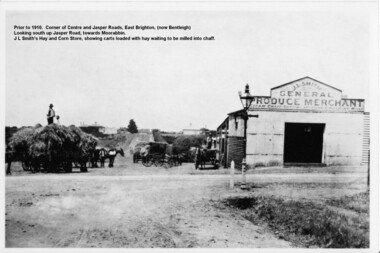
Photograph - Photograph Hay & Corn Store, Before 1910, Smith's Hay & Corn Store, Cnr. Centre and Jasper Roads, Bentleigh, Late 19th to early 20th Century
... Hay and Corn Store, situated on the South West corner of those..., situated on the South West corner of those two roads. The first ...The first photograph was taken prior to 1910. The location is at the corner of Centre and Jasper Roads, East Brighton, (now known as Bentleigh). It is an early view of John L. and "Minnie" Smith's Hay and Corn Store, situated on the South West corner of those two roads. The first photo was taken prior to the introduction of electricity in the area. A gas lamp and horse "hitching post" can be seen "in shot". There are several loaded wagons waiting in line to have their hay milled to chaff. Farmers came from places as distant as Carrum to have their loads of hay milled into chaff. John Smith was born in 1860 in Point Nepean Road, Brighton, and Minnie was born in Patterson Road, Moorabbin, in a wattle and daub cottage with earthen floor and butter muslin over the windows. The couple married in 1884, Minnie was a devout Methodist and the family became very involved in the development of the local Methodist church. The couple had four children and during the 1890s Depression their first child died, they lost all their possessions, and John's family struggled to survive. Finally in the late 1890s JL Smith was able to rent a shed from Mr Henry Box on the corner of Centre and Jasper Roads, and he later purchased that property. With the gradual improvement in the economy, and the development of the successful market gardening industry in the Shire of Moorabbin, JL Smith's produce store became quite prosperous. Over some years the little "shed" developed into a thriving Hay and Corn Store. JL Smith went on to become Moorabbin Shire President in 1914. He and his wife were active in assisting soldiers returning injured from the 1st WW, in the local Methodist Church and other early community projects. Smith was a typical example of the majority of the early settlers in the Shire of Moorabbin, being god-fearing and devoted to the idea of service to the community. The photographs demonstrate the primitive conditions and early development of what is now a bustling and well-recognised area of Bentleigh, (known as east Brighton before 1907). The photo shows a gas lamp in use before the introduction of electricity in 1916. The Smith's story is representative of the many early pioneering traders, who elected to "set up shop", who suffered the adversity of the 1890s depression, but who survived and made their living in the largely undeveloped area of East Brighton ( now Bentleigh) district. Two black and white early photographs both of the same location. The photos are of the corner of Centre and Jasper Roads, Bentleigh. (Prior to 1907 this area was known as East Brighton.) Both photos show J.L Smith's General Merchant Produce store. "Steam Chaff Cutting and Corn Crushing Mills" and the surrounding area at differing stages. In the first photo taken prior to 1910, we can see there are several horse-drawn carts loaded with hay waiting to be milled, a gas lamp and a horse "hitching post". The store is just a single unadorned, shed. The later, second photo of the same area, shows improvements and the further development of that site. On the back of the photo "Hay and Corn Store -/ not later than 1910."/"Photographer /Victor C Smith,/ Phone Number XL1472"/hitching post, methodist church, smith minnie, moorabbin shire president, gas lamp, east brighton district, 1890s depression, wattle and daub cottage, centre road, jasper road, box henry, smith john l -
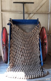
 Flagstaff Hill Maritime Museum and Village
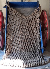
Equipment - Beach cart cover, Government of Victoria, 1860s
... lives in Warrnambool – The coastline of South West Victoria... the Harbour. Saving lives in Warrnambool – The coastline of South ...The load of heavy beach apparatus life saving equipment was held in place on the beach cart by the hand worked rope net cover. It would be stored in the Rocket House packed and ready to use for practice or rescue. Beach apparatus equipment - In the mid-1800s the equipment could include a line throwing set, coiled line in wooden carrying case, rockets, cartridges, breeches buoy, hawser and traveller block, line-throwing pistol, beach cart, hand barrow, sand anchor, crotch pole, and tools such as spade, pick, mallet and hawser cutter. Around the 1860s Warrnambool had a Rocket House installed beside the Harbour. Saving lives in Warrnambool – The coastline of South West Victoria is the site of over 600 shipwrecks and many lost lives; even in Warrnambool’s Lady Bay there were around 16 known shipwrecks between 1850 and 1905, with eight lives lost. Victoria’s Government responded to the need for lifesaving equipment and, in 1858, the provision of rocket and mortar apparatus was approved for the lifeboat stations. In 1859 the first Government-built lifeboat arrived at Warrnambool Harbour and a shed was soon built for it on the Tramway Jetty, followed by a rocket house in 1864 to safely store the rocket rescue equipment. In 1878 the buildings were moved to the Breakwater (constructed from 1874-1890), and in 1910 the new Lifeboat Warrnambool arrived with its ‘self-righting’ design. For almost a hundred years the lifesaving and rescue crews, mostly local volunteers, trained regularly to rehearse and maintain their rescue skills. They were summoned when needed by alarms, gunshots, ringing bells and foghorns. In July 1873 a brass bell was erected at Flagstaff Hill specifically to call the rescue crew upon news of a shipwreck. Some crew members became local heroes but all served an important role. Rocket apparatus was used as recently as the 1950s. This cover was used with the beach cart. The cart is significant for its connection with local history, maritime history and marine technology. Lifesaving has been an important part of the services performed from Warrnambool's very early days, supported by State and Local Government, and based on the methods and experience of Great Britain. Hundreds of shipwrecks along the coast are evidence of the rough weather and rugged coastline. Ordinary citizens, the Harbour employees, and the volunteer boat and rescue crew, saved lives in adverse circumstances. Some were recognised as heroes, others went unrecognised. In Lady Bay, Warrnambool, there were around 16 known shipwrecks between 1850 and 1905. Many lives were saved but tragically, eight lives were lost.Rectangular rope cover, hand worked for the purpose of covering the beach cart. The cover is made from heavy rope in a pattern that looks similar to crochet. A loop has been worked into each corner.flagstaff hill, warrnambool, maritime village, maritime museum, shipwreck coast, great ocean road, flagstaff hill maritime museum and village, lady bay, warrnambool harbour, port of warrnambool, shipwreck, life-saving, lifesaving, rescue crew, rescue, rocket rescue, rocket crew, beach rescue, rescue equipment, rocket rescue equipment, marine technology, lifeboat, volunteer lifesavers, volunteer crew, lifesaving rescue crew, rocket apparatus, stranded vessel, rocket rescue apparatus, beach apparatus, life jacket, rocket shed, rocket line, beach rescue set, rocket set, beach cart, hand barrow, welsh hand barrow, harbour board, government of victoria, harbour master, l.s.r.c., lsrc, rocket house -
 Ballarat Tramway Museum
Slide - 27 mm sq slide/s - set of 3, Lilian Butler, Sturt St and Ripon Sts, 1971
... Britton 26/9/2016 - by e-mail) 3 - looking west - South side...Ballarat Tramway Museum South Gardens Reserve Wendouree ...Yields information about Ripon St, Talbot St.Set of 3 Hanimex slides - what cardboard mounts: 1 - View Point line junction at Ripon St, looking north west with short tram stop pole and Ampol service station sign on the right. 2 - Water column North West corner of Sturt Street and Talbot Street (opposite the Fire Station). Column long gone. (Advised by Neville Britton 26/9/2016 - by e-mail) 3 - looking west - South side of Sturt St. Photo from the collection of Lilian Butlerballarat, tramways, trams, sturt st, view point, ripon st, tram stops -
 Melbourne Tram Museum
Letter, Australian Electric Traction Association (AETA), "Transporting Melbourne", 4/12/1996 12:00:00 AM
... Shopping centre, Highpoint West, South bank Route and other... Pier, Westfield Shopping centre, Highpoint West, South bank ...Letter - 8 A4 pages stapled in top left hand corner - AETA to "Transporting Melbourne", Ministry of Transport, dated 4-12-1996 forward comments or making a submission regarding the proposed framework. Endorse the concept, backlog in Melbourne public transport, railway electrification, tramway and light rail extensions; East Malvern Station, Box Hill, Station Pier, Westfield Shopping centre, Highpoint West, South bank Route and other suggestions made regarding re-routing of trams services.trams, tramways, aeta, submissions, new tramway, melbourne, public transport, box hill -
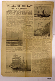 Flagstaff Hill Maritime Museum and Village
Newspaper - Newspaper clipping, 22-03-1947
... in South West Victoria. (1) The first clipping is titled Wrecks... regarding shipwrecks in South West Victoria. (1) The first clipping ...Newspaper clippings and a typed sheet regarding shipwrecks in South West Victoria. (1) The first clipping is titled Wrecks of the Last Half Century, page 12 of the Warrnambool Centenary Supplement, The Warrnambool Standard, Saturday, March 22, 1947. The ships mentioned are FREE TRADER, LA BELLA, FALLS OF HALLADALE, CASINO and CARAMBA. (2) The second clipping's main article Divers Find old shipwreck from Geoff Clancy has a handwritten date Circa Jan 30, 1960, and is possibly from a Melbourne newspaper, as it mentions non-local events. It tells of the then-current finding of the 52-year-old wreck of the Falls of Halladale near Port Campbell by skin divers. (3) Type is written 2-page article The Romance of the Clipper Ships by Basil Lubbock sub-title Falls of Halladale. The iron-hulled, four-masted barque, the Falls of Halladale, was a bulk carrier of general cargo. She left New York in August 1908 on her way to Melbourne and Sydney. In her hold, along with 56,763 tiles of unusual beautiful green American slates (roofing tiles), 5,673 coils of barbed wire, 600 stoves, 500 sewing machines, 6500 gallons of oil, 14400 gallons of benzene, and many other manufactured items, were 117 cases of crockery and glassware. Three months later and close to her destination, a navigational error caused the Falls of Halladale to be wrecked on a reef off the Peterborough headland at 3 am on the morning of the 15th of November, 1908. The captain and 29 crew members all survived, but her valuable cargo was largely lost, despite two salvage attempts in 1908-09 and 1910. ABOUT THE ‘FALLS OF HALLADALE’ (1886 - 1908): - Built: in1886 by Russell & Co., Greenock shipyards, River Clyde, Scotland, UK. The company was founded in 1870 (or 1873) as a partnership between Joseph Russell (1834-1917), Anderson Rodger and William Todd Lithgow. During the period 1882-92 Russell & Co. they standardised designs, which sped up their building process so much that they were able to build 271 ships over that time. In 1886 they introduced a 3000 ton class of sailing vessel with auxiliary engines and brace halyard winches. In 1890 they broke the world output record. Owner: Falls Line, Wright, Breakenridge & Co, 111 Union Street, Glasgow, Scotland. Configuration: Four masted sailing ship; iron-hulled barque; iron masts, wire rigging, fore & aft lifting bridges. Size: Length 83.87m x Breadth 12.6m x Depth 7.23m, Gross tonnage 2085 ton Wrecked: the night of 14th November 1908, Curdies Inlet, Peterborough south west Victoria Crew: 29 The Falls of Halladale was a four-masted sailing ship built-in 1886 in Glasgow, Scotland, for the long-distance cargo trade and was mostly used for Pacific grain trade. She was owned by Wright, Breakenridge & Co of Glasgow and was one of several Falls Line ships, all of which were named after waterfalls in Scotland. The lines flag was of red, blue and white vertical stripes. The Falls of Halladale had a sturdy construction built to carry maximum cargo and able to maintain full sail in heavy gales, one of the last of the ‘windjammers’ that sailed the Trade Route. She and her sister ship, the Falls of Garry, were the first ships in the world to include fore and aft lifting bridges. Previous to this, heavily loaded vessels could have heavy seas break along the full length of the deck, causing serious injury or even death to those on deck. The new, raised catwalk-type decking allowed the crew to move above the deck stormy conditions. This idea is still used today in the most modern tankers and cargo vessels and has proved to be an important step forward in the safety of men at sea. On 4th August 1908, with new sails, 29 crew, and 2800 tons of cargo, the Falls of Halladale left New York, bound for Melbourne and Sydney via the Cape of Good Hope. The cargo on board was valued at £35,000 and included 56,763 tiles of American slate roofing tiles (roof slates), 5,673 coils of barbed wire, 600 stoves, 500 sewing machines, 6,500 gallons of oil, 14,400 gallons of benzene, plumbing iron, 117 cases of crockery and glassware and many other manufactured items. The Falls of Halladale had been at sail for 102 days when, at 3 am on the night of 14th November 1908, under full sail in calm seas with a six knots breeze behind and misleading fog along the coast, the great vessel rose upon an ocean swell and settled on top of a submerged reef near Peterborough on south-west Victoria’s coast. The ship was jammed on the rocks and began filling with water. The crew launched the two lifeboats and all 29 crew landed safely on the beach over 4 miles away at the Bay of Islands. The postmistress at Peterborough, who kept a watch for vessels in distress, saw the stranding and sent out an alert to the local people. A rescue party went to the aid of the sailors and the Port Campbell rocket crew was dispatched, but the crew had all managed to reach shore safely by the time help arrived. The ship stayed in full sail on the rocky shelf for nearly two months, attracting hundreds of sightseers who watched her slowly disintegrate until the pounding seas and dynamiting by salvagers finally broke her back, and her remains disappeared back into deeper water. The valuable cargo was largely lost, despite two salvage attempts in 1908-09 and 1910. Further salvage operations were made from 1974-1986, during which time 22,000 slate tiles were recovered with the help of 14 oil drums to float them, plus personal artefacts, ship fittings, reams of paper and other items. The Court of Marine Inquiry in Melbourne ruled that the foundering of the ship was entirely due to Captain David Wood Thomson’s navigational error, not too technical failure of the Clyde-built ship. The shipwreck is a popular site for divers, about 300m offshore and in 3 – 15m of water. Some of the original cargo can be seen at the site, including pieces of roof slate and coils of barbed wire.The newspaper articles are of historical significance, retelling the stories of shipwrecks along the South West coast of Victoria. The Falls of Halladale shipwreck is listed on the Victorian Heritage Register (No. S255). She was one of the last ships to sail the Trade Routes. She is one of the first vessels to have fore and aft lifting bridges. She is an example of the remains of an International Cargo Ship and also represents aspects of Victoria’s shipping industry. The wreck is protected as a Historic Shipwreck under the Commonwealth Historic Shipwrecks Act (1976).Newspaper cuttings with text and photographs (3) relevant to Falls of Halladale, La Bella, Casino, Free Trader and the refurbishing of the Falls of Clyde. Also included is typewritten information about Falls of Halladale. Printed between 1947 and 1972 in Melbourne, Victoria Author of the typed article "The Romance of the Clipper Ships" was Basil Lubbock Handwritten on article "Circa: JAN 30 1960" Headline "Divers find old shipwreck" "Geoff Clancy" "Not salvaged" "Still wedged" "Falls of Halladale" Typed pages: "THE ROMANCE OF THE CLIPPER SHIPS BY BASIL LUBBOCK" "FALLS OF HALLADALE" flagstaff hill, warrnambool, shipwrecked-coast, flagstaff-hill, flagstaff-hill-maritime-museum, maritime-museum, shipwreck-coast, flagstaff-hill-maritime-village, falls of halladale, la bella, falls of clyde, freetrader, casino, coramba, geoff clancy, warrnambool standard january 30 1947, warrnambool centenary supplement 1947, wrecks of the last half century, newspaper article divers find by geoff clancy, the romance of the clipper ships by basil lubbock, free trader, speculant, clipper ship, shipwrecks -
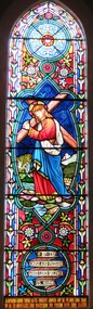 Christ Church Anglican Parish of Warrnambool
Memorial window: William RUTLEDGE, "BY THY CROSS AND PASSION GOOD LORD DELIVER US""
... in Victoria. In south west Victoria that interest being especially... in Victoria. In south west Victoria that interest being especially ...William Rutledge [born 1806, Ireland] was a self-made, larger-than-life man who involved himself prominently in business, municipal, political, community and social aspects of life. Eldest son of James and Martha [nee Forster], William arrived in Australia from Ireland in 1829 and within six years had sufficiently established himself to purchase land in New South Wales. He married Eliza Kirk in Sydney in august 1840. They had two sons and five daughters. In 1843 he began his association and life in Port Fairy and soon became prominent and influential in almost all aspects of that developing town. His interests encompassed mercantile, civic, pastoral, shipping, importing, exporting, immigration, politics and social aspects with in the district and colony. He was a major contributor to the building of St John’s Anglican Church, Port Fairy. He acquired three special surveys with historical importance in Victoria. In south west Victoria that interest being especially the Farnham Survey of 5120 acres between Dennington and Tower Hill/Killarney. This was farmed by immigrant tenant and lessee farmers, some of whom were brought to the Australia at William Rutledge’s own expense and by whom he was considered a kind and considerate landlord. His endeavours were not without failures and in 1862 his Port Fairy Company failed with debts of over £170,000. This debt was redeemed in full within a year. According to reported accounts, William Rutledge had a tempestuous manner with an “explosive” temper, although he did not hold grudges. This is countered by accounts of his kindness, generosity, honesty and practical, progressive outlook in all his undertakings. After the failure and closure of his Company, William Rutledge moved to his property at Farnham Park near Warrnambool where he concentrated his interest in breeding sheep and horses. Throughout his life his home was reputed to be convivial and hospitable. William Rutledge died at Farnham Park on June 1st, 1876. William Rutledge's place in the history of settlement in south west Victoria gives importance to this memorial.Stained glass window, south wall, main nave, depicting Jesus bearing the Cross. The background is quite floral. A medallion shape holds the title as printed on a ribbon: "By thy cross and passion good Lord deliver us".In Latin: In Memoriam Gulielmi Rutledge qui A.D. MDCCCVI underimo ante Kal: Feb: natus vitam posuit/ Kal: Jun: MDCCCLXXVI Filae amantissimae hanc fenestram pietatis indirio posueruntrutledge, william rutledge, farnham survey, port fairy, christ church warrnambool -
 Flagstaff Hill Maritime Museum and Village
Vehicle - Beach cart and cover, Government of Victoria, 1860s
... the Harbour. Saving lives in Warrnambool – The coastline of South... – The coastline of South West Victoria is the site of over 600 shipwrecks ...The beach cart was hand drawn by a team of six people; two in front, one on each side and two behind. The wide iron tyres on the the wheels helped prevent the cart from sinking into the sand. The load of heavy beach apparatus equipment was held in place by the hand worked rope net cover. It would be stored in the Rocket House packed and ready to use for practice or rescue. Beach apparatus equipment - In the mid-1800s the equipment could include a line throwing set, coiled line in wooden carrying case, rockets, cartridges, breeches buoy, hawser and traveller block, line-throwing pistol, beach cart, hand barrow, sand anchor, crotch pole, and tools such as spade, pick, mallet and hawser cutter. Around the 1860s Warrnambool had a Rocket House installed beside the Harbour. Saving lives in Warrnambool – The coastline of South West Victoria is the site of over 600 shipwrecks and many lost lives; even in Warrnambool’s Lady Bay there were around 16 known shipwrecks between 1850 and 1905, with eight lives lost. Victoria’s Government responded to the need for lifesaving equipment and, in 1858, the provision of rocket and mortar apparatus was approved for the lifeboat stations. In 1859 the first Government-built lifeboat arrived at Warrnambool Harbour and a shed was soon built for it on the Tramway Jetty, followed by a rocket house in 1864 to safely store the rocket rescue equipment. In 1878 the buildings were moved to the Breakwater (constructed from 1874-1890), and in 1910 the new Lifeboat Warrnambool arrived with its ‘self-righting’ design. For almost a hundred years the lifesaving and rescue crews, mostly local volunteers, trained regularly to rehearse and maintain their rescue skills. They were summoned when needed by alarms, gunshots, ringing bells and foghorns. In July 1873 a brass bell was erected at Flagstaff Hill specifically to call the rescue crew upon news of a shipwreck. Some crew members became local heroes but all served an important role. Rocket apparatus was used as recently as the 1950s. This cart and cover set is significant for its connection with local history, maritime history and marine technology. Lifesaving has been an important part of the services performed from Warrnambool's very early days, supported by State and Local Government, and based on the methods and experience of Great Britain. Hundreds of shipwrecks along the coast are evidence of the rough weather and rugged coastline. Ordinary citizens, the Harbour employees, and the volunteer boat and rescue crew, saved lives in adverse circumstances. Some were recognised as heroes, others went unrecognised. In Lady Bay, Warrnambool, there were around 16 known shipwrecks between 1850 and 1905. Many lives were saved but tragically, eight lives were lost.Beach cart; a blue and white painted, wooden cart with two, red coloured metal wheels. The wheels have twelve spokes and wide iron tyres. The cart has a long draw bar with T- handles at the end. It was pulled by two people, usually steered by another two and pushed by a further two. It was supplied by the Government of Victoria. There is an inscription on the front end panel. The cart has a removable hand worked rope cover. Stencilled in white paint “G of V” flagstaff hill, warrnambool, maritime village, maritime museum, shipwreck coast, great ocean road, flagstaff hill maritime museum and village, lady bay, warrnambool harbour, port of warrnambool, shipwreck, life-saving, lifesaving, rescue crew, rescue, rocket rescue, rocket crew, beach rescue, rescue equipment, rocket rescue equipment, rocket equipment, marine technology, lifeboat, volunteer lifesavers, volunteer crew, lifesaving rescue crew, rocket apparatus, shore to ship, stranded vessel, rocket rescue apparatus, line thrower, beach apparatus, breeches buoy, life jacket, rocket house, rocket shed, rocket machine, rocket head, rocket launcher, rocket line, beach rescue set, rocket set, beach cart, hand barrow, welsh hand barrow, harbour board, government of victoria, harbour master, l.s.r.c., lsrc