Showing 1675 items
matching the grove
-
 Bendigo Military Museum
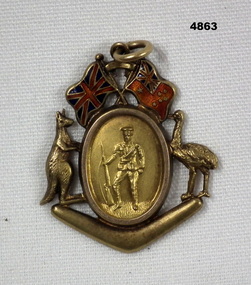
Badge - SHIRE BADGE, Post 1919
It appears that the badge has the wrong name spelling and should most likely be “HUTCHESON”. He was born in the Parish of Pine Grove, Wanurp District is in the same area. James Hutcheson had pre war training with the 4th LH at Mitiamo. Enlisted in the AIF 16.3.1916 age 33 years 5 months in the 1st Reinforcements 38th Bn, Embark for England 20.6.1916, disembark 10.8.1916, hospital with “Chill” 19.10.1916 then diagnosed with “Mumps”, rejoin unit 5.11.1916, embark for France 22.11.1916, Hospital 4.12.1916 with “Bronchitis” then finally “Tracheitis”, rejoin unit 2.3.1917, classed as Coy Driver 20.6.1917, WIA 27.7.1917 remaining on duty, embark for England 15.4.1919, embark for Australia 27.5.1919, discharged from the AIF 4.9.1919.Badge brass with central oval shape with image of a soldier, two flags at top each side has either a kangaroo or emu, under is a boomerang shape, ring at top for a chain/other.Rear, “Presented by Wanurp District League to Driver Jas Hutchinson for services rendered in the Great War 1914 - 1919”services rendered, wanurp, great war -
 City of Moorabbin Historical Society (Operating the Box Cottage Museum)
Photographs, 7 x B&W Circa 1918 Cheltenham Methodist Youth Group, Circa 1918 Photos of Cheltenham Methodist Youth Group, 1918
Circa 1918: Various Photos of the Cheltenham Methodist Youth Group. Row 1 and 2: "At Flinders". Row 3: 1st Left, "Holidaying at Cockatoo". in 1852 Stephen Charman, who had arrived in Melbourne 1842 aged 21 years as one of Henry Dendy's emigrants, purchased 160 acres in Spring Grove ( now Cheltenham). Stephen and his family lived in a wattle and daub hut and worked hard to establish a market garden, poultry and pig farm. The first Methodist Church Services were held at their home. In 1855 Stephen gave 1 acre of his land on Balcombe Road to the Methodist Church for a School, Burial ground and a Chapel which was built in 1857.The Methodist Church, Balcombe Road was the 2nd religious building to be erected in Spring Grove now known as Cheltenham c 18577 small black and white photographs of the Cheltenham Methodist Youth Group at Flinders, Cockatoo and unkown locations, c 1918 . First 3 photos are of male cyclists on a trip to Flinders, Victoria. Photo 4 shows 6 ladies and a man on holiday at Cockatoo in the Dandenong Ranges ,Victoria . Photos 5 to 7 show men, women and children in bushland surroundings of unrecorded locations.Photo 1 - 3 on back : Flinders 1918 Photo 4 left on back : Holiday at Cockatoo right on back : Whitehead Photo 5-7 nilcheltenham, cheltenham methodist youth group, 1914, 1918, charman stephen, gettens mary, spring grove, methodist church, charman road, balcombe road, dendy henry, henry dendy's special survey 1841, youth groups, social groups, market gardners, early settlers, pioneers, dairy farmers, poultry farmers, pig farmers,moorabbin, brighton, -
 Ringwood and District Historical Society
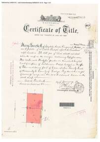
Document, Certificate of Title - Mary Burchett, Lilydale Road, Ringwood - part of Crown Section 20, Parish of Warrandyte, County of Evelyn - 14th January, 1910
A4 copies of Landata Victoria Historical Search documents - Vol 3398 Fol 679415.Mary Burchett of Lilydale Road, Ringwood, Married Woman, is now the proprietor of an Estate in Fee-simple subject to the Encumbrances notified hereunder ... 55 acres 3 roods 35 perches or thereabouts, being lots 8 and 9 on plan of subdivision no.4315. Subdivision map includes un-named road - Grandview Grove (later Bemboka Road, Warranwood, Vic). Title transferred to Theodore Hartley Burchett, 27th July, 1911. -
 Tatura Irrigation & Wartime Camps Museum
Photograph, State School No. 1441
Front Row: Keith Holden, George Taylor(?) Ted Normington, Bruce Manning, Lennie Sutton (?), Fred Westwood, Lea Rose, .. Strong, Jack Taylor. 2nd Row:Fred ..., Jack Chalmers, Alan Hurren, Ken Forsyth, Don Cackran, Jam Mactier, Ron Anderson, Charlie Taylor, Lea Gledhill. 3rd Row: Harvey Ponting, George Sutton, .. McDonald, Nancy Hatherly, Shirley Hurren, Grace Taylor, Joyce Layton, Roslyn Ward,Wilma Anderson, Betty Pritchard, ..., Bob Ward, .... Back Row ..., Jack Porter, ..., Marj. Connors, ..., Marj Ward, Ethel Williams, Joan Hastie, Dorothy Maskell, Jean Pyke, ..., ..., Colin Grovesstate school 1441 c1927, photography, photograph, slides, film -
 Kew Historical Society Inc
Photograph - 29 Uvadale Grove, Kew, 1920
The numerous subdivision plans in the Kew Historical Society's collection represent working documents, ranging from the initial sketches made in planning a subdivision to printed plans on which auctioneers or agents listed the prices for which individual lots were sold. In a number of cases, the reverse of a subdivision plan in the collection includes a photograph of a house that was also for sale by the agent. Subdivision plans are historically important documents used as evidence of the growth of suburbs in Australia. They frequently provide information about when the land was sold on which a built structure was subsequently constructed as well as evidence relating to surveyors and real estate and financial agents. These photographs provide significant heritage information relating house design and decoration, fencing and household gardens.When 29 Uvadale Grove, Kew was offered for sale it was described as: ‘Kew. Fine locality, 3 minutes Cotham Road. Splendidly built 6 roomed Brick Villa. Rooms 17 x 14, 16 x 13, &c. Beautifully fitted throughout. Land 70 x 134 to ROW.’ The price was advertised as being £1,400. The house exhibits key features of Federation architecture such as the gabled roof with a facing of half-timber and stucco. The veranda has a curved corrugated iron roof supported by timber pillars and fretwork. The slate roof with terra cotta ridging and finials marks a transition to the more common use of Marseilles tiles in Federation architecture.subdivisions - kew (vic.), 29 uvadale grove - kew (vic.) -
 Kew Historical Society Inc
Plan - Subdivision Plan, Windella-Darnley Subdivision, Studley Park, 1920s
Subdivision plans are historically important documents used as evidence of the growth of suburbs in Australia. They frequently provide information about when the land was sold on which a built structure was subsequently constructed as well as evidence relating to surveyors and real estate and financial agents. The numerous subdivision plans in the Kew Historical Society's collection represent working documents, ranging from the initial sketches made in planning a subdivision to printed plans on which auctioneers or agents listed the prices for which individual lots were sold. In a number of cases, the reverse of a subdivision plan in the collection includes a photograph of a house that was also for sale by the agent. These photographs provide significant heritage information relating house design and decoration, fencing and household gardens.Version 2 of two subdivision plans (the earlier is 2016.0305.1) for the section of Studley Park Road near the Junction on the south side. Named in the subdivision are the mansions of Darley and Windella (now demolished). Before the subdivision of Darley and Windella, both houses fronted Studley Park Road. Both houses appear to be advertised as lots in the subdivision. Bisecting the subdivision is a street, Antrim Avenue that was never constructed. A street, which was subsequently constructed in this vicinity, was Merrion Place, which now runs between Studley Park Road and Highfield Grove. There are 13 proposed lots in this subdivision in contrast to the earlier plan. This resulted from larger lots being proposed for Studley Park Road.subdivision plans - kew, studley park, windella, darnley, antrim avenue -- kew (vic.), studley park road -- kew (vic.), merrion place -- kew (vic.), merrion grove -- kew (vic.), highbury grove -- kew (vic.) -
 Old Colonists' Association of Ballarat Inc.
Photograph - Image, The History of Charles Anderson and Charles Anderson Grove, Ballarat
Information relating to Charles Anderson and Charles Anderson Grove, Lake Gardens, Ballarat. The Old Colonists' Association Ballarat Inc. is a not for profit charitable organisation providing accommodation for elderly people. It manages a 27 Home retirement village at Charles Anderson Grove, Ballarat. Accommodation is offered at significantly below market rates. It has been providing low cost accommodation to the elderly since the 1920s. The Association Council overseas the running of this facility on a voluntary basis. HISTORY OF THE BALLARAT OLD COLONISTS' ASSOCIATION HOMES AT CHARLES ANDERSON GROVE, LAKE GARDENS One of the original objectives of the Association was “to provide the shelter of a house for those Pioneers of the Goldfields whom the reverses of fortune have deprived of the means of procuring the comforts of life in their declining years.” While the first home at Charles Anderson Grove was built in 1925 the Association had previously provided relief for needy pioneers from the time it was formed in 1883. Relief included monthly monetary payments, loads of firewood, medical assistance and distribution of Christmas boxes of groceries to deserving pensioners and in some cases payment of burial costs. Records indicate that in September 1922 three of the pensioners being assisted by the Association were accepted as residents in the newly erected Hassell Homes in Gillies Street (now demolished-opposite the High School). The first site for an Asylum for Indigent Members of the Old Colonists' Association was temporarily reserved from sale in October 1891. The site was approximately 28 acres in area in Mt Clear nearly opposite Midvale Shopping Centre in Main Road. The site was heavily timbered and when cleared over 260 tons of wood was sold to the Woah Hawp Gold Mining Company. A set of gates were erected but no homes built, although a plan for this reserve was drawn which showed twenty buildings ranging from one to four unit per building. The reserve was revoked in November 1909. The second site temporarily reserved in November 1909 as an Asylum was in Alfredton and consisted of some 7 acres and was adjacent to land reserved for an Abattoirs for the Ballarat Council. The reserve was revoked in February 1912 as it was deemed more appropriate to be added to the Abattoir site. Council suggested four (4) other sites in exchange for this land and they were inspected by the President, Vice President and Secretary on 22 December 1912. The first site inspected was land on the west side of Creswick Road opposite the brick kilns (now occupied by the showgrounds and oval). The land was described as being good quality, well fenced, no trees, good drainage and ample acreage but some distance from trams. The second site was Perry Park which was described as being good land, well fenced, having frontage to Gillies Street, good drainage and about 26 acres (but subsequently reduced to 10 acres). It was closely planted with Pinus Insignias and Wattle and had easy access from the Botanic Gardens tram. The third site was the North West portion of Victoria Park (corner of Sturt and Gillies Street) and was described as good land, well fenced and drained and well located. The fourth site was the South West corner of Victoria Park and known as Pound Paddock (corner of Winter Street and Gillies Street). It was considered to be low lying and too close to the Abattoir, and was also a considerable distance from trams. While the third site was recommended as the most suitable for the erection of homes it was considered unwise from the point of view as citizens to reduce the acreage of the park and therefore it was recommended that the Perry Park site be asked for as the most acceptable to the Association for the building of homes. The site was eventually temporarily reserved for an Asylum for Indigent Members of the Association in April 1914 with the gates from Mt Clear having been removed to the site a year earlier and eventually erected in 1917 for £12.10.0. In the same year the first 290 pine trees were advertised for removal in July and sold for £16. A sign indicating that the site was reserved for the erection of cottages was erected in September 1917. Stripping of the wattle bark (for tanning) and the cutting of the wood occurred in November 1918 with the land then being leased until it was required for the construction of the first homes in 1924. While the site was the third to be reserved it was the only one which was used for its intended purpose. It was named as Charles Anderson Grove in honour of Charles Anderson who joined the Association in 1918 and was President of the Association from 1942 to 1944. CHARLES HENRY GRATTAN ANDERSON C.H.G. Anderson (Electoral Returning Officer) was elected to membership of the Old Colonists' Association, Ballarat, in October 1918. He was elected to the Association Committee in 1926, and appointed Treasurer of the Association on the resignation of F. Ellis until the end of the financial year in 1933. In 1936 Charles Anderson indicated he would not be available for the President's Chair and that he would retire from the Committee owing to pressure of work. C.H.G. Anderson was welcomed as a new member of the Association in 1938, and served as President of the Old Colonists' Association from 1942-1944. Midway through 1949 Charles Anderson was appointed Members Secretary and Manager of the Ballarat Old Colonists' Club at £5.0.0 per week and 10/- for entertainment, to commence work prior to 01 August 1949. He was to do 30 hours per week and be present on Friday and generally on Saturday nights. In 1957 a minute of sympathy was extended to Club Manager Charles Anderson on the loss of his son. In 1958 a bonus of £20.0.0 was paid to Charles Anderson in recognition of his service in assisting the Secretary/Manager taking over under difficult conditions. In March 1964 the Shire of Ballarat would not permit a private road to be named Anderson Grove as Anderson Street already existed in Ballarat but Charles Anderson Grove was deemed acceptable. A recommendation of the Committee was put to the AGM in 1967 that Charles Anderson be made a Life Member. In 1969 an Association meeting observed a minutes silence in memory of Chas Anderson. Charles Anderson was also a Committee member of Ballarat Mechanics' Institute from February 1940 to February 1970. He was President in 1948. Black and white photographic portrait of Charles Anderson.charles anderson, charles anderson grove, ballarat old colonists' club, old colonists' association, ballarat, ballarat mechanics' institute, hassell homes, woah hawp gold mining company, firewood, retirement village -
 Orbost & District Historical Society
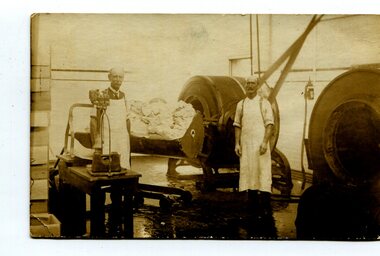
black and white photograph, C1900
This photograph shows Mr John Scouller, the manager, on the left with His assistant, Fred ?. Mr Scouller was the manager of the Orbost Butter Factory for 30 years and was succeeded by Mr Stafford after his retirement. The Orbost Butter and Produce Co. Ltd was registered on June 1st, 1892.The first shipment to England went rank and was only good for axle grease on wagons and carts.The milk was brought to the factory by horse and dray.Most people would take the whey home for their pigs,which were abundant on the farms in the Orbost district. First directors – James Nixon (chairman), James Cameron, Carl H. Grove, Harry Richardson, David Rhys Morris, Lachlan Ross. The factory opened 11th January, 1893 with John Scouller as the manager. The Orbost Butter and Produce Co. Ltd was registered on June 1st 1893 and was an important source of income to the Orbost district.A black / white photograph of two men standing near machinery inside the Orbost Butter Factory.on back - " Orbost. m. Gilbert. J. Scouller, Fred?????. Donated by Colin Perry"orbost-butter-factory scouller-john dairying -
 Kew Historical Society Inc
Photograph - 'Neama', Studley Park Road, 1978
Edward Augustus Atkyns was born in Wiltshire, England in 1840. His family emigrated to Australia in 1852. As a young man he was a keen cricketer and played at the first cricket ground in the district, located between Barkers Road and Hawthorn Grove, on the site of the future Barker railway station. Atkyns was admitted to the Victorian Bar in 1861, initially working in his father’s practice. He sat as a local magistrate in both Kew and Hawthorn and acted as solicitor for several shire councils. Elected to the Hawthorn Borough Council in 1863 at the age of 23, he served in that municipality as mayor in 1866-67. By 1877, he had moved to Kew where he lived at Neama in Studley Park Road, a property later incorporated into the St Paul’s School for the Blind.Rare colour photograph of what was once a significant house in Kew.Original colour positive photograph (Kodak print) of the main house of 'Neama', colloquially known as the 'farmhouse'. Photographed by Stewart West in April 1978 (it was later demolished by the Villa Maria Society).Annotated reverse: "Front view of Neama / Farmhouse on St Paul's School for the Blind Children / Fernhurst Estate"st paul's school for the blind, neama, studley park road -- kew (vic.), historic houses -- kew (vic.), villa maria society -
 Kew Historical Society Inc
Photograph - 'Neama', Studley Park Road, 1978
Edward Augustus Atkyns was born in Wiltshire, England in 1840. His family emigrated to Australia in 1852. As a young man he was a keen cricketer and played at the first cricket ground in the district, located between Barkers Road and Hawthorn Grove, on the site of the future Barker railway station. Atkyns was admitted to the Victorian Bar in 1861, initially working in his father’s practice. He sat as a local magistrate in both Kew and Hawthorn and acted as solicitor for several shire councils. Elected to the Hawthorn Borough Council in 1863 at the age of 23, he served in that municipality as mayor in 1866-67. By 1877, he had moved to Kew where he lived at Neama in Studley Park Road, a property later incorporated into the St Paul’s School for the Blind.Rare colour photograph of what was once a significant house in Kew.Original colour positive photograph (Kodak print) of the secondary building at 'Neama', colloquially known as the 'hall'. Photographed by Stewart West in April 1978 (it was later demolished by the Villa Maria Society).Annotated reverse: "Timber hall on Fernhurst land / Transported there approx 1878."st paul's school for the blind, neama, studley park road -- kew (vic.), historic houses -- kew (vic.), villa maria society -
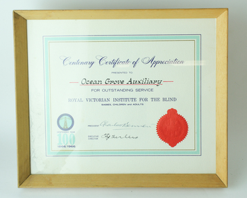 Vision Australia
Administrative record - Text, RVIB Ocean Grove Auxiliary, 1944-2005
The Ocean Grove RVIB Auxiliary formed on July 31, 1944. This collection of papers includes the minute books from 1944 until 2002 and printed minutes from 2002 to the conclusion of the Auxiliiary in 2004. The papers include newspaper clippings, correspondence, secretary and annual reports, 1999-2005 syllabus (list of events), lists of office bearers and balance sheets. A signboard for the Auxiliary's kiosk in 1951, a poem from the last President Dot Whitehead and the acknowledgement letter from RVIB regarding the Auxiliary's final donation and decision to conclude are also here. The index cards were maintained by RVIB and contain the amount of donations made by the Auxiliary between 1976-1995, as well as the presentations delivered by RVIB employees to Auxiliary meetings between 1973-1985.6 minute books -- 1 receipts book -- 2 index cards -- various loose papers -- signboard -- receipts & expenditure book -- certificate.royal victorian institute for the blind, auxiliaries -
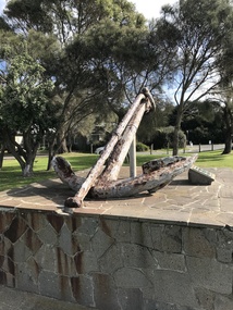 Barwon Estuary Heritage Centre
Equipment - Anchor from the Earl of Charlemont
The Earl of Charlemont was a medium-sized, 878 ton passenger ship built at Saint John, New Brunswick, Canada, in 1849. It sailed from the Port of Liverpool on 13 March 1853 with 366 passengers plus crew, captained by William Gardner. The first port of call was to be Port Phillip, Australia, before continuing to Sydney with the majority of the passengers. After a passage of 97 days the ship reached Cape Otway on 17 June and set a course for Port Phillip some 56 miles away. At 5.15 a.m. on the 19 June 1853 the ship struck a reef (later named Charlemont Reef) about 1½ miles from Barwon Heads. The anchor was raised by Barwon Grove Skin Divers on June 25 1972. Wrought iron anchor -
 Eltham District Historical Society Inc
Photograph, Stokes family with horse and sled, Nyora Road, Eltham, c.1950, 1950c
Taken from outside the family home on the southest corner of the intersection of Nyora Road and Pitt Street with Eucalyptus Road, looking northeast across the Stokes Orchard Frank Stokes with children, Dorothy (left), Beryl and David Frank Stokes first traveled to the district by train in 1944 to find land with the intention to establish an orchard. By chance he met Arthur Bird of Bird Orchard (bounded by Pitt Street, Eucalyptus Road and Wattle Grove) and they got talking over their common interest. Arthur put Frank up for the night and pointed out the land, part of Crown Allotment 15, Section 5, Parish of Nillumbik (CA15) somewhat diagonally opposite Bird Orchard. Frank bought the land and for the next two years would travel by train from Melbourne to Eltham every weekend establishing Stokes Orchard and building a home for his family, which they eventually moved into in 1946. In the mid 1970s the Shire of Eltham divided the orchard up into numerous rate-able parcel lots, which became affordable for Frank. As a consequence Stokes Orchard was turned into a housing development by Macquarie Builders and marketed as the Stokes Orchard Estate in two stages; Stage 1 encompassing Scarlet Ash Court, Ironbark Close and Peppermint Grove bounded by Nyora and Eucalyptus roads c.1976 and Stage 2 encompassing Stokes Place, Orchard Way, The Crest and The Lookout bound by Nyora and Diosma roads c.1979. The development of Orchard Way, The Crest and The Lookout did not proceed as planned due to the lack of the sewer along Diosma Road and so many of the proposed lots were incorporated into five-acre parcels instead.Representative of the orchard growing areas of ElthamDigital file only - Digitised by EDHS from a scrapbook (containing commercially printed photos of digital scans) on loan from Beryl Bradbury (nee Stokes), daughter of Frank Stokes.1950, beryl bradbury (nee stokes), beryl bradbury (nee stokes) collection, david stokes, dorothy stokes, eltham, frank stokes, horse, nyora road, sled, stokes orchard -
 Eltham District Historical Society Inc
Photograph, Looking south towards Nyora Road, Eltham, 1977, 1977
Viewed from near the end of Stokes Place where the linear reserve now runs between 8 and 9 Stokes Place just visible through trees in foreground, 24 Nyora with red roof is the first house in middle of view. Frank Stokes first traveled to the district by train in 1944 to find land with the intention to establish an orchard. By chance he met Arthur Bird of Bird Orchard (bounded by Pitt Street, Eucalyptus Road and Wattle Grove) and they got talking over their common interest. Arthur put Frank up for the night and pointed out the land, part of Crown Allotment 15, Section 5, Parish of Nillumbik (CA15) somewhat diagonally opposite Bird Orchard. Frank bought the land and for the next two years would travel by train from Melbourne to Eltham every weekend establishing Stokes Orchard and building a home for his family, which they eventually moved into in 1946. In the mid 1970s the Shire of Eltham divided the orchard up into numerous rate-able parcel lots, which became affordable for Frank. As a consequence Stokes Orchard was turned into a housing development by Macquarie Builders and marketed as the Stokes Orchard Estate in two stages; Stage 1 encompassing Scarlet Ash Court, Ironbark Close and Peppermint Grove bounded by Nyora and Eucalyptus roads c.1976 and Stage 2 encompassing Stokes Place, Orchard Way, The Crest and The Lookout bound by Nyora and Diosma roads c.1979. The development of Orchard Way, The Crest and The Lookout did not proceed as planned due to the lack of the sewer along Diosma Road and so many of the proposed lots were incorporated into five-acre parcels instead.Housing development in Eltham as an extension to the Woodridge EstateDigital file only - Digitised by EDHS from a scrapbook (containing commercially printed photos of digital scans) on loan from Beryl Bradbury (nee Stokes), daughter of Frank Stokes.1977, beryl bradbury (nee stokes) collection, nyora road, stokes orchard estate, stokes place -
 Eltham District Historical Society Inc
Photograph, Stokes Place, Eltham, July 1977, July 1977
Viewed from near the end of Stokes Place where the linear reserve now runs between 8 and 9 Stokes Place looking slightly east of south towards Nyora Road. The new Christian Church on Nyora now the Baptist Church visible in middle view. Frank Stokes first traveled to the district by train in 1944 to find land with the intention to establish an orchard. By chance he met Arthur Bird of Bird Orchard (bounded by Pitt Street, Eucalyptus Road and Wattle Grove) and they got talking over their common interest. Arthur put Frank up for the night and pointed out the land, part of Crown Allotment 15, Section 5, Parish of Nillumbik (CA15) somewhat diagonally opposite Bird Orchard. Frank bought the land and for the next two years would travel by train from Melbourne to Eltham every weekend establishing Stokes Orchard and building a home for his family, which they eventually moved into in 1946. In the mid 1970s the Shire of Eltham divided the orchard up into numerous rate-able parcel lots, which became affordable for Frank. As a consequence Stokes Orchard was turned into a housing development by Macquarie Builders and marketed as the Stokes Orchard Estate in two stages; Stage 1 encompassing Scarlet Ash Court, Ironbark Close and Peppermint Grove bounded by Nyora and Eucalyptus roads c.1976 and Stage 2 encompassing Stokes Place, Orchard Way, The Crest and The Lookout bound by Nyora and Diosma roads c.1979. The development of Orchard Way, The Crest and The Lookout did not proceed as planned due to the lack of the sewer along Diosma Road and so many of the proposed lots were incorporated into five-acre parcels instead.Housing development in Eltham as an extension to the Woodridge EstateDigital file only - Digitised by EDHS from a scrapbook (containing commercially printed photos of digital scans) on loan from Beryl Bradbury (nee Stokes), daughter of Frank Stokes.1977-07, beryl bradbury (nee stokes) collection, eltham, eltham christian church, stokes orchard estate, stokes place -
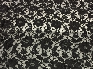
 Kew Historical Society Inc
Clothing - Black lace evening dress, 1930s
Doris Mercy Willmott was born in May 1896 in Stamford Hill, London, the eldest of three daughters of Albert and Minnie Willmott. The family lived in various parts of north London until the beginning of the First World War, when they moved to Redhill in Surrey. It was in Redhill that Doris met her future husband, Frederick John (Jack) Bennett. Jack had met Eric Mercy, a cousin of Minnie’s, in the Australian Imperial Force (AIF) and visited the Wilmotts with him whilst on leave from France. Although Jack Bennett returned to Melbourne in March 1919, he and Doris continued to correspond and they were engaged in March 1923. She came to Melbourne on her own, and was married in the Congregational Church in Canterbury on 23 December 1923. By 1931 Doris and Jack and their three sons - John Willmott, Winfield Robert Curtis and Peter Reginald Dane - moved to 21 Tooronga Road, Hawthorn but moved back to his father’s home, Therapia, 2 (now 6) Hepburn Street, Auburn, shortly before his father’s death. In 1937, the Bennett family moved back to the United Kingdom, spending the war years in Uxbridge and Torquay. The family returned to Melbourne in October 1946, after the deaths of Doris’ parents. The family lived at 12 Stanhope Grove, Camberwell and 51 The Ridge, Canterbury before Jack died in February 1952. After this Doris moved to 12 Stanley Grove, Canterbury, her home until c. 1970 when she moved to 25 Corhampton Road, North Balwyn. She died in May 1980 in Princeton Nursing Home, 3 Bellett Street, Camberwell. (Adapted from notes provided by Sue Barnett, the donor).The collection of evening clothes owned and worn by Doris Mercy Bennett, of which this item is one, date from the 1930s and may have been purchased in Australia or in the United Kingdom. Each of the items, apart from the evening dress, which has a few minor tears in the lace, is of fine quality and evidences Doris Bennett’s love of glamour and style. While the evening dress and the mantilla are of the same fabric, the two capes might have been worn with the dress as alternative fashion accessories. None of the items has a maker’s mark, however each displays evidence of fine dressmaking skills. It is however probable that the two fitted capes were commercially made.Long black lace, floor-length evening dress extending to a short train at the back. The dress has a belt at the waist that is joined by two white metal clasps studded with diamentes. With the dress there is also a matching lace square (2017.00921) that might have been used as a mantilla or as a shawl. The dress was owned and worn by Doris Mercy Bennett (nee Willmott) [1896-1980], and donated to the Society by her grandaughter. women's clothing, evening wear, evening dresses, doris bennett (nee wilmott) -
 Kew Historical Society Inc
Clothing - Evening Wear, Black Lace Shawl, circa 1930s, 1930s
Doris Mercy Willmott was born in May 1896 in Stamford Hill, London, the eldest of three daughters of Albert and Minnie Willmott. The family lived in various parts of north London until the beginning of the First World War, when they moved to Redhill in Surrey. It was in Redhill that Doris met her future husband, Frederick John (Jack) Bennett. Jack had met Eric Mercy, a cousin of Minnie’s, in the Australian Imperial Force (AIF) and visited the Wilmotts with him whilst on leave from France. Although Jack Bennett returned to Melbourne in March 1919, he and Doris continued to correspond and they were engaged in March 1923. She came to Melbourne on her own, and was married in the Congregational Church in Canterbury on 23 December 1923. By 1931 Doris and Jack and their three sons - John Willmott, Winfield Robert Curtis and Peter Reginald Dane - moved to 21 Tooronga Road, Hawthorn but moved back to his father’s home, Therapia, 2 (now 6) Hepburn Street, Auburn, shortly before his father’s death. In 1937, the Bennett family moved back to the United Kingdom, spending the war years in Uxbridge and Torquay. The family returned to Melbourne in October 1946, after the deaths of Doris’ parents. The family lived at 12 Stanhope Grove, Camberwell and 51 The Ridge, Canterbury before Jack died in February 1952. After this Doris moved to 12 Stanley Grove, Canterbury, her home until c. 1970 when she moved to 25 Corhampton Road, North Balwyn. She died in May 1980 in Princeton Nursing Home, 3 Bellett Street, Camberwell. (Adapted from notes provided by Sue Barnett, the donor).The collection of evening clothes owned and worn by Doris Mercy Bennett, of which this item is one, date from the 1930s and may have been purchased in Australia or in the United Kingdom. Each of the items, apart from the evening dress, which has a few minor tears in the lace, is of fine quality and evidences Doris Bennett’s love of glamour and style. While the evening dress and the mantilla are of the same fabric, the two capes might have been worn with the dress as alternative fashion accessories. None of the items has a maker’s mark, however each displays evidence of fine dressmaking skills. It is however probable that the two fitted capes were commercially made.With the black lace evening dress (2917.0093.1) there is also a matching lace square with long lace ties (2017.0093.2) that might have been used as a mantilla or as a shawl. The outfit was owned and worn by Doris Mercy Bennett (nee Willmott) [1896-1980], and donated to the Society by her grandaughter. women's clothing, evening wear, shawls, lace, doris bennet (nee willmott) -
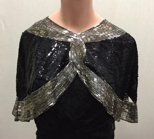 Kew Historical Society Inc
Clothing - Evening Wear, Black and Silver Sequin Capelet, 1930s, 1930s
Doris Mercy Willmott was born in May 1896 in Stamford Hill, London, the eldest of three daughters of Albert and Minnie Willmott. The family lived in various parts of north London until the beginning of the First World War, when they moved to Redhill in Surrey. It was in Redhill that Doris met her future husband, Frederick John (Jack) Bennett. Jack had met Eric Mercy, a cousin of Minnie’s, in the Australian Imperial Force (AIF) and visited the Wilmotts with him whilst on leave from France. Although Jack Bennett returned to Melbourne in March 1919, he and Doris continued to correspond and they were engaged in March 1923. She came to Melbourne on her own, and was married in the Congregational Church in Canterbury on 23 December 1923. By 1931 Doris and Jack and their three sons - John Willmott, Winfield Robert Curtis and Peter Reginald Dane - moved to 21 Tooronga Road, Hawthorn but moved back to his father’s home, Therapia, 2 (now 6) Hepburn Street, Auburn, shortly before his father’s death. In 1937, the Bennett family moved back to the United Kingdom, spending the war years in Uxbridge and Torquay. The family returned to Melbourne in October 1946, after the deaths of Doris’ parents. The family lived at 12 Stanhope Grove, Camberwell and 51 The Ridge, Canterbury before Jack died in February 1952. After this Doris moved to 12 Stanley Grove, Canterbury, her home until c. 1970 when she moved to 25 Corhampton Road, North Balwyn. She died in May 1980 in Princeton Nursing Home, 3 Bellett Street, Camberwell. (Adapted from notes provided by Sue Barnett, the donor).The collection of evening clothes owned and worn by Doris Mercy Bennett, of which this item is one, date from the 1930s and may have been purchased in Australia or in the United Kingdom. Each of the items, apart from the evening dress, which has a few minor tears in the lace, is of fine quality and evidences Doris Bennett’s love of glamour and style. While the evening dress and the mantilla are of the same fabric, the two capes might have been worn with the dress as alternative fashion accessories. None of the items has a maker’s mark, however each displays evidence of fine dressmaking skills. It is however probable that the two fitted capes were commercially made.Black silk chiffon or georgette fitted evening cape,let entirely covered in silver metal rectangles and black sequins. The cape gives the appearance of being joined at the front, however it is made in one piece. The cape has open scalloped sections bordering the lower band of silver metal rectangles. The cape was owned and worn by Doris Mercy Bennett (nee Willmott) [1896-1980], and donated to the Society by her grandaughter. evening wear, capelets, doris bennett (nee wilmott), women's clothing -
 Kew Historical Society Inc
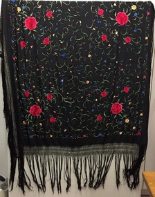
Clothing - Shawl, Manton de Manila, 1930s
Doris Mercy Willmott was born in May 1896 in Stamford Hill, London, the eldest of three daughters of Albert and Minnie Willmott. The family lived in various parts of north London until the beginning of the First World War, when they moved to Redhill in Surrey. It was in Redhill that Doris met her future husband, Frederick John (Jack) Bennett. Jack had met Eric Mercy, a cousin of Minnie’s, in the Australian Imperial Force (AIF) and visited the Wilmotts with him whilst on leave from France. Although Jack Bennett returned to Melbourne in March 1919, he and Doris continued to correspond and they were engaged in March 1923. She came to Melbourne on her own, and was married in the Congregational Church in Canterbury on 23 December 1923. By 1931 Doris and Jack and their three sons - John Willmott, Winfield Robert Curtis and Peter Reginald Dane - moved to 21 Tooronga Road, Hawthorn but moved back to his father’s home, Therapia, 2 (now 6) Hepburn Street, Auburn, shortly before his father’s death. In 1937, the Bennett family moved back to the United Kingdom, spending the war years in Uxbridge and Torquay. The family returned to Melbourne in October 1946, after the deaths of Doris’ parents. The family lived at 12 Stanhope Grove, Camberwell and 51 The Ridge, Canterbury before Jack died in February 1952. After this Doris moved to 12 Stanley Grove, Canterbury, her home until c. 1970 when she moved to 25 Corhampton Road, North Balwyn. She died in May 1980 in Princeton Nursing Home, 3 Bellett Street, Camberwell. (Adapted from notes provided by Sue Barnett, the donor).Black silk, with multi-coloured embroiderery Manton de Manila shawl. The shawl was owned and once worn by Doris Mercy Bennett (nee Willmott) [1896-1980], and donated to the Society by her grandaughter. It probably dates from the 1930s.evening wear, piano shawl, manton de manila, doris bennett (nee wilmot), women's clothing -
 Ringwood and District Historical Society
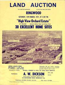
Flyer, Land Auction Sale Brochure, High View Orchard Estate, Ringwood, Vic. - 1971
Double-sided advertisement for Ringwood High View Orchard Estate land auction sale on Saturday, 13th March, 1971, including aerial photograph, map, and summary of local facilities and services.Subdivision includes Wonga Road, Oban Road, Sang Court, Ambrie Avenue, Hendra Grove, and Mullum Mullum Road. Agent - A.W. Dickson Pty. Ltd., 136 Whitehorse Road, Ringwood, 3134. Telephones: 870 6000, 870 6007, 870 7016, after hours 870 6868. A separate copy of the advertisement includes a local newspaper follow-up clipping reports thirty home sites grossing $102,350 at the auction. -
 Peterborough History Group
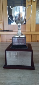
Memorabilia - Peterborough Golf Club Ladies C Grade Championship
The Ladies C Grade championship starting in 1991. Winners were: 1991 P Bradshaw, 1992 D Smith, 1993 D Irvine, 1994 N Wills, 1995 D Delaney, 1996 E Spies, 1997 K Bul, 1998 M Smith, 1999 J Bogner, 2000 A. Deppeler, 2001 M O'Connor, 2002 M Bacon, 2003 Jenny Stevens, 2004 M Smith, 2005 Jenny Cunnington, 2006 L Norton, 2007 J Nesseler, 2008 M Price, 2009 J Irwin, 2010 H Finlayson, 2011 H Finlayson, 2012 K Matheson, 2013 K Matheson, 2014 K Morrison, 2015 L Norton, 2016 L Norton, 2017 L Norton, 2018 A Thompson, 2019 F Groves.Significant as it provides a record of C grade winners over the years. Also provides a snapshot of playersSmall silver cup on a pedestalInscribed with the competition title and the names and year of the winnerspeterborough golf club, peterborough, women's golf, women's golf championships -
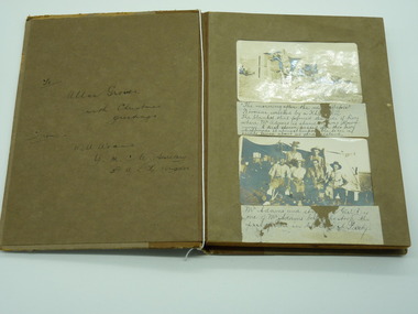 Lara RSL Sub Branch
Photograph Album, To Allan Groves, 1917
Cardboard Album Khaki coloured 8 leaves with photos and written descriptionsFront sleeve To Allan Groves With Christmas greetings from Will Adams YMCA Secretary with A.L.H. Brigade There are explanations under each couple of photos too much to write in this space. In general the photos are of Will Adams experience in Egypt The Rafa Raid Prisoners of war, Beni Selah women waiting for water. Women making bricks, 53rd Casualty Clearing Station destroyed by a bomb, Royal Scots Fusilier Pipe Band after church parade, The Sultan Hasser Mosque photograph, album, egyp, ww1, allan groves, will adams, rafa raid, 53rd casualty clearing station -
 Eltham District Historical Society Inc
Photograph, Stokes family, Nyora Road, Eltham, c.1952, 1952c
Taken from outside the family home on the southest corner of the intersection of Nyora Road and Pitt Street with Eucalyptus Road, looking northeast across the Stokes Orchard L-R: David, Howard, Beryl (kneeling), Dorothy and Gladys Stokes with Gladys's mother sitting in Gladys's father's car with Spot the dog, Nyora Road, Eltham, c.1952 Frank Stokes first traveled to the district by train in 1944 to find land with the intention to establish an orchard. By chance he met Arthur Bird of Bird Orchard (bounded by Pitt Street, Eucalyptus Road and Wattle Grove) and they got talking over their common interest. Arthur put Frank up for the night and pointed out the land, part of Crown Allotment 15, Section 5, Parish of Nillumbik (CA15) somewhat diagonally opposite Bird Orchard. Frank bought the land and for the next two years would travel by train from Melbourne to Eltham every weekend establishing Stokes Orchard and building a home for his family, which they eventually moved into in 1946. In the mid 1970s the Shire of Eltham divided the orchard up into numerous rate-able parcel lots, which became affordable for Frank. As a consequence Stokes Orchard was turned into a housing development by Macquarie Builders and marketed as the Stokes Orchard Estate in two stages; Stage 1 encompassing Scarlet Ash Court, Ironbark Close and Peppermint Grove bounded by Nyora and Eucalyptus roads c.1976 and Stage 2 encompassing Stokes Place, Orchard Way, The Crest and The Lookout bound by Nyora and Diosma roads c.1979. The development of Orchard Way, The Crest and The Lookout did not proceed as planned due to the lack of the sewer along Diosma Road and so many of the proposed lots were incorporated into five-acre parcels instead.Representative of the orchard growing areas of ElthamDigital file only - Digitised by EDHS from a scrapbook (containing commercially printed photos of digital scans) on loan from Beryl Bradbury (nee Stokes), daughter of Frank Stokes.1948-1951 vauxhall velox, 1948-1951 vauxhall wyvern, 1952, beryl bradbury (nee stokes), beryl bradbury (nee stokes) collection, david stokes, dorothy stokes, eltham, gladys stokes, nyora road, spot (dog), stokes orchard -
 Kew Historical Society Inc
Plan, Sydney Arnold Best & Co, Field Place, Kew, c.1929
Pru Sanderson, in her groundbreaking ‘City of Kew Urban Conservation Study : Volume 2 - Development History’ (1988), summarised the periods of urban development and subdivisions of land in Kew. The periods that she identified included 1845-1880, 1880-1893, 1893-1921, 1921-1933, 1933-1943, and Post-War Development. These periods were selected as they represented periods of rapid growth or decline in urban development. An obvious starting point for Sanderson’s groupings involved population growth and the associated economic cycles. These cycles also highlighted urban expansion onto land that was predominantly rural, although in other cases it represented the decline and breakup of large estates. A number of the plans in the Kew Historical Society’s collection can also be found in other collections, such as those of the State Library of Victoria and the Boroondara Library Service. A number are however unique to the collection.The Kew Historical Society collection includes almost 100 subdivision plans pertaining to suburbs of the City of Melbourne. Most of these are of Kew, Kew East or Studley Park, although a smaller number are plans of Camberwell, Deepdene, Balwyn and Hawthorn. It is believed that the majority of the plans were gifted to the Society by persons connected with the real estate firm - J. R. Mathers and McMillan, 136 Cotham Road, Kew. The Plans in the collection are rarely in pristine form, being working plans on which the agent would write notes and record lots sold and the prices of these. The subdivision plans are historically significant examples of the growth of urban Melbourne from the beginning of the 20th Century up until the 1980s. A number of the plans are double-sided and often include a photograph on the reverse. A number of the latter are by noted photographers such as J.E. Barnes.An unnamed subdivision in Studley Park including five lots for sale in Studley Park Road, Highfield Grove and Tara Avenue. Unidentified on the plan, but clearly existing, are the Henty family mansion of Field Place and Tara Hall in Studley Park Road. The first attempted subdivision of Tara Hall was advertised in 1927 in which Lots 5, 6 and 7 in this plan were also advertised. Unusually, Lot 2 in Studley Park Road was created from the northern part of the Henty mansion, rather than Tara Hall. In the subdivision, lots were advertised at varying prices, with the highest price for land being Lot 2 in Studley Park Road. The plan notes that only one villa is to be allowed on each allotment.subdivision plans - kew, field place subdivision -- studley park – kew (vic.), highfield grove – kew (vic.), tara avenue – kew (vic.) -
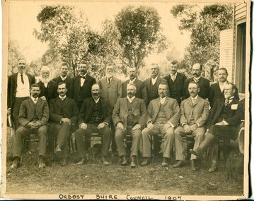 Orbost & District Historical Society
black and white photograph, Howard D. Bulmer, 1907
This photograph shows the Orbost Shire Council in 1907. In the back row are : A. Hillyard; John Draffin (sec.); David Jonson; Archie Rodwell; Hugh Cameron; Geotge Nixon; J. Hassett; Percy Watt; Wm Anderson (engineer); Wm Ross (S.R. Mail) Seated in front on chairs are : Sam Lynn; R. Pearse; John Johnston; Henry Luke (pres.); Donald Munro; Bill Cumming; Charles Grove The shire covered an area of 9,347 square kilometres and existed from 1892 until 1994 when it became part of the East Gippsland Shire Council. Orbost was at first included in the Bairnsdale Shire from 1882 and was later part of the Tambo Shire. Because of travelling distances the Croajingalong Shire was created in 1892 (name changed to Orbost Shire 17.2.1893 with James Cameron as the first Shire President. In 1994 it amalgamated to become part of East Gippsland Shire Council.This item is associated with the Orbost Shire Council. The shire covered an area of 9,347 square kilometres and existed from 1892 until 1994 when it became part of the East Gippsland Shire Council. A large black / white photograph of a group of men in two rows - front row seated; back row standing. The photograph has been taken outdoors with trees in the background and to the right a wooden building and tank. There is a copy.on front - "Orbost Shire Council - 1907" on back - "March, 1907, Shire Council"orbost-shire-council-1907 local-government -
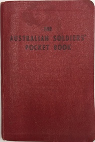 Kew Historical Society Inc
Book, Brown, Prior, Anderson Pty Ltd, The Australian Soldiers' Pocket Book : Containing useful information for Australian soldiers, 1940
Booklet produced in 1940 for members of the 2nd AIF by the Australian Comforts Fund Victorian Division. The 128-page pocket-sized book could be carried everywhere and provided Australian soldiers with a wide range of useful information about the requirements of war service and many other important details such as: The Laws and Customs of War - including Geneva Convention guidelines, notes on spies and insignia of rank; Things a Soldier should Know - including over 60 points; Signaling - including flags, morse code, shipboard bell times and time zone; Decorations Awarded to Australians in the Great War; Arabic and Japanese words; First Aid for gas injuries etc.; Australian Historical Events, facts and figures etc.; and Conduct Overseas - including expectations of behaviour when representing Australia. non-fictionaustralian comforts fund (victoria), second world war 1939-1945, hugh george ferguson -
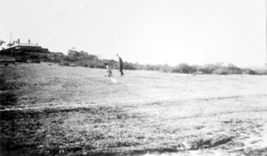 Surrey Hills Historical Society Collection
Photograph, Land in Everton Grove, Surrey Hills in 1927, 1927
The vacant land was the site of Norman Carter's future home at 21 Everton Grove. Norman Broadley Carter (1899-1984) married Mabel Annie Moore in 1927. Norman was an engineer with a passion for photography. Norman took many photos of Surrey Hills and Mont Albert from the 1920s and particularly of events and activities of the Church of England. For many years the house on the left located at 14 Harding Street belonged to the Kenneth Rothwell Culliton and his wife (Fanny) Molly Culliton. The house is located next to the Harding Street Reserve. Ken was an engineer and Molly was an early member of the Surrey Hills Historical Society. Ken was born and died in Surrey Hills. His father Harry Culliton was a well known golfer. His mother Christina Mary Rothwell was the daughter of Thomas Talbot Rothwell, known as a tea merchant and importer; also lived in Surrey Hills. This image is significant for its documentation of pre-urban Surrey Hills.Black and white photo of an area of gently sloping mown grass. On the horizon is a line of trees and on the LHS the outline of a (?) Victorian house can be seen. A man and a young boy are playing in the open space.everton grove, harding street, kenneth rothwell culliton, miss fanny molly arthur, mrs fanny molly culliton, norman broadley carter, mabel annie moore, mabel annie carter -
 Surrey Hills Historical Society Collection
Photograph, Surrey Hills Church of Christ football team, 1940, 1940
In 1940 The Surrey Hills Church of Christ team played in A Grade of the Eastern Suburbs Protestant Churches Football Association. Other clubs competing that season were: Spring Road Methodist, Glendearg Grove Methodist, Burwood Protestant, St.Marys Church of England, Balwyn United, Box Hill Adelphian and Box Hill United. Alan Sneddon played in the team. The inauguration of the Association took place at a meeting held at Camberwell Methodist School Office on the 19 March 1923. The following churches were represented at this meeting: Auburn Presbyterian, Kew Presbyterian, Hawthorn Presbyterian, Camberwell Methodist, Canterbury Methodist and St Marks Church of England, Burke Road and Holy Trinity Church of England, Surrey Hills. From 1923 to 1992 there were at least 160 clubs / teams that competed through the various grades with many of these combining & /or changing names, as well as those that competed irregularly. Black and white photo of the 1940 Surrey Hills Church of Christ football team with the Eastern Suburbs Football Association premiers flag in the background. The team includes 18 players, an umpire and 3 club officials, the later are centrally seated and one holds the premiership cup.Black and white photo measuring L 20.4 cm x H 15.4 cm mounted on its original presentation folder, which is mounted on card. The photographer's details are beneath the photo on the original mount, partially obscured by the descriptive label. The script is indecipherable.On back of card in Jocelyn Hall's writing: "Have 5 of these studio photos. / One is marked 'ORIGINAL' / ( - safekeeping) / This is Centre copy".churches, espcfa, surrey hills church of christ, football, football clubs, sporting clubs, eastern suburbs protestant churches football association, alan sneddon -
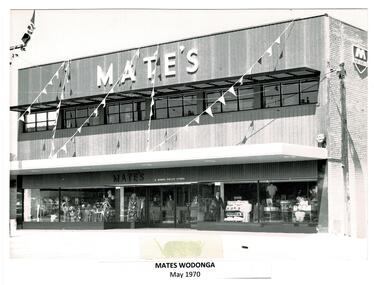 Wodonga & District Historical Society Inc
Photograph - Codling Collection 01 - Mates Wodonga
Miss Olive Codling was a Foundation Member and a Life Member of the Wodonga Historical Society. Many of her prize-winning photos are held in the Society Collection. MATE's WODONGA - T. H. Mate opened his first store in Albury in 1850. The company was sold to Burns Philp in 1946, although they continued trading as Mate’s. Burns Philp policy was to maintain the identity of stores they took over with the same staff and management. The Mate’s store in Wodonga was built by local builders A. B. and M. A. Chick. It was a 3 level development in High Street opposite Woodland Grove. It included a mezzanine eating area. Mate’s closed in 1976 when Burns Philp sold the business to Waltons. In 1987 they became Venture Stores. This building also later became Highpoint and Fosseys which closed in 2000. In 2023 it is the Gateway Health building.This photo collection is significant as it documents how the businesses and buildings in Wodonga have evolved and contributed to community throughout the 20th century.2 black and white images of the Mate's Store in Wodonga. Image 1 shows the completed building. Image 2 shows the store under construction. On image 1: Across the top of the building: "MATE'S" Above the door: "MATE'S A BURNS PHILP STORE" wodonga businesses, high st wodonga, mates wodonga -
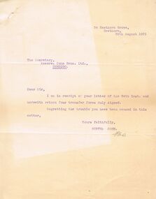 Bendigo Historical Society Inc.
Document - COHN BROTHERS COLLECTION: TYPED LETTER DATED 1921
a. Typed letter to the secretary Messrs Cohn Bros ltd from Bertha Cohn 54 Hawthorn Grove Hawthorn dated 29th August 1921 re four signed transfer forms. .b Handwritten attachment altering in Alice Cohn's name 128 shares to Alice Cohn. 60 to Ray Cohn. 32 to Clare Cohn, and adding new issue, signed Bertha Cohn. The 1534 lot of shares remain in estate of Roschen Cohn in name of Max Cohn as Trustee in said Estate. Alice Cohn, Ray Cohn, Clare Cohn recipients. .c Handwritten correspondence dated August 22nd 1921 to Messrs Cohn Bros re share certificates in Julius & Max Cohn, Mathilda & Bertha Cohn, & Alice Cohn namesbendigo, industry, cohn bros brewery, bertha & mathilda cohn. cohns brewery