Showing 20684 items matching "time-allotment"
-
 Nhill Aviation Heritage Centre
Verbal Time Announcer
Not certain if this equipment was used at NhillRack mounted, Gives verbal time at set intervals, Includes operators manualPlessey Verbal Time Announcer Rola Company Australia Product of VT13time announcer, aeradio -
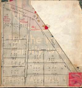
 Bacchus Marsh & District Historical Society
Map, Allotments in the Village of Rowsley, Parish of Gorrocburkghap, County of Grant c.1856
Rowsley is a locality 11 kilometers south-west of Bacchus Marsh. The date of this map is uncertain. A very similar map held by the State Library of Victoria (SLV) contains slightly more information than this copy and is dated as an 1856 map. SLV reference: 'Allotments in the Village of Rowsley, Parish of Gorrocburkghap, County of Grant', by T. Nixon, Assistant Surveyor, May 1856 ; Surveyor General’s Office, July 18 1856 (lithographed by R. Meikle). (1856). Melbourne: Surveyor General’s Office. MAPS 820 BJE 1837- ROWSLEY 1856. A single page paper map. A cadastral map of the Village of Rowsley in Victoria, showing numbered land allotments. 57 allotments are shown on the map and some areas set aside as reserves. Allotments 8, and 10-16 are outlined in red ink and allotment 9 has a cross in red ink on it. The map is pasted into a bound volume containing 76 maps or plans in total. High resolution digital image stored on BMDHS computer network. rowsley victoria history, rowsley victoria maps -
Stawell Historical Society Inc
Photograph, Uniting Church Manse Capsule, 21.12.2022
Steven Green fitting BricksThree Colour Photographs, of laying of Manse Time capsuleUniting Church Manse Time Capsule information from 1920 nad 2022 to be opened in 2120religion -
 Ringwood and District Historical Society
Map, Subdivision Plan of residential allotments on Canterbury Road, Bayswater (later surrounding Miller Road, Heathmont), Victoria - (Undated - circa 1930s)
Hand-drawn map on cardboard backing. Includes red pen notations marking allotments sold to Mrs A. Harrison, Mrs C Cornwall, J.M. Miller, and A.W. Dickson.Red pen notations mark allotments sold to Mrs A. Harrison, Mrs C Cornwall, J.M. Miller, and A.W. Dickson. Later subdivision of the map area took in Miller Road and Atunga Court developments. -
 Bacchus Marsh & District Historical Society
Map, Plan of the second portion of the property of Messers Atkins and Clarke situate at Bacchus Marsh 1856
This plan of land allotments for sale indicates part of the property once owned by the Bacchus family in and around the township area of Bacchus Marsh. The Bacchus family sold their property in Bacchus Marsh to John Aitkins and Robert Nalder Clarke in March 1851. Aitkins and Clarke kept the property for a number of years until April 1856 when these allotments were put up for sale.This is a very early land sales plan for agricultural land close to the township of Bacchus Marsh. It therefore provides some clues as to how the early urban development of the township and agricultural development of the nearby area took place. Upon seeing the map in 1911 Bacchus Marsh Express newspaper editor Christopher Crisp wrote "The sale appears to have created the present township, which had a nucleus in earlier times further east", Express, 30 September, 1911, page 3.A single page paper plan showing allotments of land for sale. The subdivided land shown was owned by John Aitkins and Robert Nalder Clarke, but previously owned by the Bacchus Family and was in and around their Manor House (Mansion) property in Bacchus Marsh. This plan shows allotments in the second portion of land to be sold which was located east of the Manor House on the eastern side of the Lerderderg River. The land for sale was made up of 15 allotments. The plan is pasted into a bound volume containing 76 maps or plans in total. BMDHS Loc: AR/B12/S4 Bacchus Marsh Township and Nearby Districts Maps Volume In-house Digital copies: BMDHS, Computer Network: Maps\Bacchus Marsh Township and Nearby Districts Maps Volumebacchus marsh victoria maps, bacchus family, land sales, manor house bacchus marsh -
 Peterborough History Group
Map - Map of the town, Government Printer, Township of Peterborough
Map donated by Barry Jenkins and assume that updated names were written on the map by him. Good information pertaining to the history of each allotment. Significant as it shows the names of the owners of each allotment in 1931 and handwritten notes of more recent owners.27/6/1931 paper map of the township of Peterborough including names of the landowners at that time.Handwritten landowner names over the original printed names.peterborough, old maps, maps -
 Bendigo Military Museum
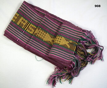
Memorabilia - SASH, TIMOR, C.1998 - 2002
Native woven souvenir sash from East Timor. Pink, green, brown & gold bands alternating in vertical & horizontal stripes on each side, fringed ends.“East Timor repeated on woven central design”costume accessories-female, memorabilia, handcrafts- embroidery, military history - souvenirs, timor -
 Rutherglen Historical Society
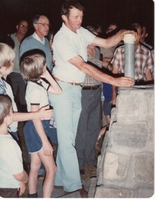
Image, 23/11/1980
Colour photograph of a group of children clustered around a nearly completed time capsule.On back of photo: "Children around time capsule cairn Rutherglen Showgrounds 23-11-80"time capsule, cairn, rutherglen showgrounds, monuments -
 Rutherglen Historical Society
Image, 23/11/1980
Colour photograph of a man about to lower a sealed time capsule into a cairn.On back of photo: "John Williams placing time capsule in cairn. Rutherglen Showgrounds 23-11-80"rutherglen showgrounds, time capsule, cairn, monuments, john williams -
Whitehorse Historical Society Inc.
Document, McGlone's Estate Mitcham, 1/04/1921 12:00:00 AM
Copy of pamphlet of McGlone's Estate, Mitcham auctioned April 1921.Copy of pamphlet of McGlone's Estate, Mitcham auctioned April 1921. 24 allotments. Bordered by Whitehorse Road, McGlone Street, Station Street and Mitcham railway line and station. Original in Haughton maps, LaTrobe Library.Copy of pamphlet of McGlone's Estate, Mitcham auctioned April 1921. land sales, auctions, mcglone, john, mcglone, elizabeth, whitehorse road, mitcham, mcglone street, mitcham, station street, mitcham, mitcham railway station, haughton map collection, state library of victoria. latrobe library -
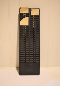 National Wool Museum
Functional object - Time Card Rack
A time clock, sometimes known as a clock card machine, punch clock, or time recorder, is a device that recorded the time an employee entered and left the factory. In mechanical time clocks, this was accomplished by inserting a heavy paper card, called a time card, into a slot on the time clock. When the time card hit a contact at the rear of the slot, the machine would print day and time information (a timestamp) on the card. One or more time cards could serve as a time sheet or provide the data to fill one. This allowed a timekeeper to have an official record of the hours an employee worked to calculate the pay owed an employee.Metal time card rack.time sheet, time card, factory, employee, work life, punch clock, textile industry -
 Bendigo Military Museum
Postcard - XMAS CARD, 4/11/200
Interfet Christmas card. Blue background with flag border. Map of East Timor with peace dove.“INTERFET -International Force East Timor Peace” Postmarked Melbourne City Mail Centre November 2000documents-cards, maps, interfet, east timor -
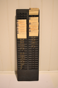 National Wool Museum
Functional object - Time Card Rack
A time clock, sometimes known as a clock card machine, punch clock, or time recorder, is a device that recorded the time an employee entered and left the factory. In mechanical time clocks, this was accomplished by inserting a heavy paper card, called a time card, into a slot on the time clock. When the time card hit a contact at the rear of the slot, the machine would print day and time information (a timestamp) on the card. One or more time cards could serve as a timesheet or provide the data to fill one. This allowed a timekeeper to have an official record of the hours an employee worked to calculate the pay owed an employee.Metal time card rack.time card, rack, employee, factory, timesheet, data, mechanical, punch clock -
Whitehorse Historical Society Inc.
Map, Site for Wesleyan Church, Nunawading, 1855
Photocopy of manuscript map showing names of landholders.Photocopy of manuscript map showing names of landholders. Note on verso: Plan of allotments in the City of Melbourne appropriated to the Wesleyans. Site for Wesleyan Church, Nunawading 1848 (Corner of Burwood and Elgar Roads - S of Burwood, W of Elgar)Photocopy of manuscript map showing names of landholders. churches, wesleyan church, burwood, burwood road, burwood, elgar road, burwood, maps -
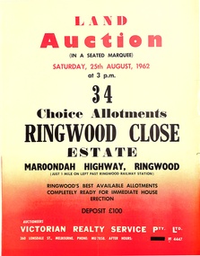 Ringwood and District Historical Society
Pamphlet, Land Auction Brochure - Ringwood Close Estate, Ringwood, Victoria - 1962
Brochure advertising public auction of 34 allotments on Saturday 25th August, 1962. Brochure includes terms of sale, description of subdivision features and local facilities, with locality map. Subdivision includes Anthony Court, Nina Court and Wingrove Place, off Maroondah Highway, Ringwood.Auctioneer - Lindsay Lord, Victorian Realty Service Pty Ltd., 360 Lonsdale Street, Melbourne. Phone MU7858, After hours XF4447. Map includes handwritten pricing notations for some allotments. -
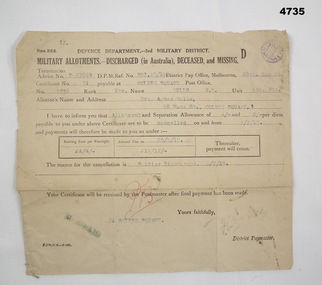 Bendigo Military Museum
Financial record - MILITARY ALLOTMENTS, Department of defence 3rd Military District, 6.7.1918
Norman McKenzie Rolls. The document relates to the cancellation of allotments from him to his Mother Mrs Agnes Rolls of Golden Square Bendigo.Document off white colour rectangular shape form Z.C.2, all print in black, typed in blue, initialled in red, purple stampin top RH corner, termination advice no “D27869”. Form relates to Military allotments for discharged, deceased or missing Soldier.Main points re Soldier, “No 3938 Pte Rolls, N.M 5th BTN”allotments, documents, payments -
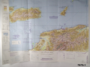 Bendigo Military Museum
Map - MAPS, EAST TIMOR, US Govt et al, 1975 - 1976
1. This is a coloured map. It's scale is 1.250,000 - called a jpoint operations graphic. It covers the North side of East Timor. Dili is in the centre. Its shows 4 Islands to the north of Timor. It shows Savu Fea, Ombai Strait, Wetar Strait. On bottom left of map it shows Batheade and the start of the New Border. Map - Series 159. Sheet 5C- 51-4. Edition 3-GSGS. 2. This is a coloured map. Its scale is 1.250,000 called a joint Operations Graphic. It manly covers West Timor. It shows Savu Sea in North and Timor Sea on south side. Series 1501. Sheet SC 51.7. Edition 3-GSGS. 3. This a coloured map. It's scale is 1.250,000. Joint operations graphic. This map shows the south side of East Timor and the Timor Sea. This map shows a highlighted New border. The major towns on South coast are KAMFNASA, BETANO. Map series 1501. Sheet SC 51-8. Edition 3 GSGS.1. Has highlighted "7 BSG" on coast. All maps show East Timor border highlighted in pink.east timor, maps, interfet -
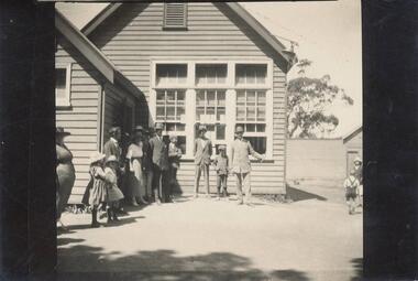 Phillip Island and District Historical Society Inc.
Photograph, 1921
One of 23 photographs from the Jessie Smith Collection. Donated by Stan McFeeBlack & White photograph of Men, Women and Children in front of Cowes School. Lord Stradbroke & sons ringing the bell for the first time.On back: "Lord Stradbroke & sons ringing bell at Cowes School for first time." (signed) J.S.cowes school, phillip island, lord stradbroke, jessie smith collection, stan mcfee -
 Numurkah & District Historical Society
Cricket Club time capsule
The time capsule was buried 31-03-1984 And was raised 29-01-2017Numurkah Cricket Club Time Capsule, stainless steel And accompanying photos of the time capsulenumurkah cricket club, time capsule, history, 1984, 2017 -
Whitehorse Historical Society Inc.
Document, Certificate of Title, 1922, 1933
Certificate of Title, Margaret Kennedy.Certificate of Title, Margaret Kennedy. Lots 100, 101 & 102, subdivision 1968, part of crown allotment 1270, Parish of Nunawading, County of Bourke 1922 vol 4583, fol 916577 also rates enforcement of charge, 1933.Certificate of Title, Margaret Kennedy.land titles, shire of blackburn and mitcham, kennedy, margaret, mcdowall street, mitcham -
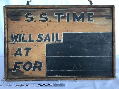 Queenscliffe Maritime Museum
Sailing Notice Board from the SS Time
Timber notice board used at the booking office for the SS Time to indicate sailing informationSailing Notice Board made of timberSS Time; Will Sail; At; For ss time, corsair rock, notice board -
Whitehorse Historical Society Inc.
Document, Certificate of Title, 1915, 1933
Certificate of Title, Frederick William GibbonsCertificate of Title, Frederick William Gibbons, Lot 88, Subdivision 1968, part of crown allotment 1270, Parish of Nunawading, County of Bourke 1915. Vol 3882, fol 776385 also correspondence re rates, enforcement of charge, 1933.Certificate of Title, Frederick William Gibbonsland titles, shire of blackburn and mitcham, gibbons, frederick william, shire of nunawading, burnett street, mitcham, gort road, mitcham -
 Bacchus Marsh & District Historical Society
Map, Main Road and Gell Street Allotments
This map shows allotments of land along Gell Street Bacchus Marsh running between Main Road (now called Main Street) and Lerderderg Street. The total area of the map encompasses Main Road, Church Street, Lerderderg Street and Gell Street. 36 allotments of land are shown. Three allotments which connect to Main Road are shaded in pink. The date of the map has not been established but the National Bank building erected in 1865 near the Border Inn is indicated which indicates that the map dates from after 1865. Reports in the Bacchus Marsh Express newspaper on 5 March 1870, page 2, column 6 announced building lots in Gell Street had been withdrawn from sale by the agent J.E. Crook. Later reports in the Express on 1 November 1873, page 2, column 2 advertised 14 allotments of land in Gell Street for sale. Single page map showing allotments of land along the Main Road (Main Street) and Gell Street areas of Bacchus Marsh. Part of a set of maps which are pasted into a bound volume containing 76 maps or plans in total. High resolution digital image stored on BMDHS computer network. bacchus marsh victoria maps, gell street land allotments, main street land allotments -
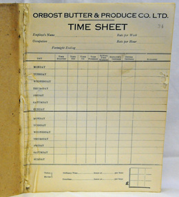 Orbost & District Historical Society
time sheet book, circa 1930's
This was used by the The Orbost Butter and Produce Co. Ltd .The Orbost Butter and Produce Co. Ltd was registered on June 1st 1893 and was an important source of income to the Orbost district.A paper/cardboard time sheet book. Some sheets - pp 1-33 - have been torn out at the front. Only the back page has been filled in. On each page as header - Orbost Butter & Produce Co. Ltd. TIME SHEETorbost-butter-factory agriculture farming time-book -
 Wodonga & District Historical Society Inc
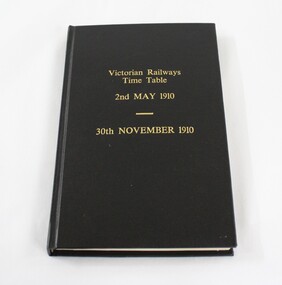
Administrative record - Victorian Railways Time Table 1910
The Wodonga line and train station opened in November 1873 when the section of the line from Wangaratta was completed. The expansion of the railways to the northeast of Victoria occurred after the Victorian Government took over the railways in 1867 and the trains serviced large towns such as Seymour, Wangaratta and Wodonga, as well as smaller towns along the way. The first section of the Wodonga to Tallangatta line opened in 1889 and was further extended in 1891. It was a vital community link until the passenger service closed in September 1961 The last regular goods train on the line ran on 21st April 1978. The north- east train line to Wodonga remained a significant factor in the development of Wodonga as a rural city in the 20th century. Local significance due to the importance of the railways to Wodonga as a means of transport, communication and impact on business and commerce. State and national significance due to the role played by the railways in opening up the country for development.A bound volume of the Victorian Railways Time Table for 2nd May 1910 to 30th November 1910. Black with gold inscription. The binding is not original but was carried out to preserve the contents"Victorian Railways/Time Table/ 2nd May 1910/ 30th November 1910"victorian railways, wodonga, timetable, transport -
 Ballan Shire Historical Society
Map - Map. Bungal, Department of Lands and Survey, Bungal, County of Grant, 09/09/1926
A map of Bungal in the 1920's showing the allotments, and the size, with the names of the residents. It shows the roads and the Western and Eastern Moorarbool River, and the Whipstick State Forest.Cream coloured map of Bungal in the County of Grant, bounded by the the East Moorarbool River on the East, and the State Forest on the South. It is marked with the scale of chains and the number L.358. Lithographed at the Department of Lands and Survey. Melbourne by W. J. Butson on 9.9.1926. It shows the land allotments with names of owners.Coloured pen marks and circled numbers on various areas. Price 2 shillings marked on bottom right hand edge.bungal, kerrit bareet, egerton, lal lal, borhoneyghurk, bungeeltap, ballark, yaloak, gorong, moorarbool west -
Whitehorse Historical Society Inc.
Document, Certificate of Title, 1923 - 1934
Certificate of Title, William Arthur Hirst.Certificate of Title, William Arthur Hirst. Lot 20 Subdivision 6626, part of crown allotment 127A at Mitcham, Parish of Nunawading, Count of Bourke. Vol 4671, fol 934063. Also correspondence re rates enforcement charge, 1933-34.Certificate of Title, William Arthur Hirst.land titles, shire of blackburn and mitcham, hirst, william arthur, shire of nunawading, thomas street, mitcham -
 Bacchus Marsh & District Historical Society
Map, Bacchus Marsh Suburban Allotments Parwan Road Lodge & Dunn's Paddocks 1888
This map was created as a plan for an auction of land close to the Bacchus Marsh Railway Station. The auction took place on 23 October 1888. 102 allotments of land from an area known as Lodge and Dunn's paddocks was offered for sale. A single page paper map showing allotments of land for sale along the Parwan Road in Maddingley. The map is pasted into a bound volume containing 76 maps or plans in total. High resolution digital image stored on BMDHS computer network. land sales bacchus marsh, land sales maddingley, bacchus marsh victoria maps, maddingley victoria maps -
 Ringwood and District Historical Society
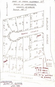
Map, Subdivision Plan - Adam Court area, North Ringwood, Vic. - circa 1960s
Single page plan printed showing allotments included in un-named subdivision layout surrounding Adam Court, Ringwood North. Subdivision includes Adam Court, Burlock Avenue, and Felix Crescent. Sold allotmenets marked in red, with price notations.Page heading - Part of Crown Allotment 27B Parish of Warrandyte County of Evelyn Scale 60'-1". Rubber stamp imprint and handwritten address at bottom of page - "Binburra Estates Pty. Ltd. 23 Pitt St., Ringwood, 870-1184". -
![Map, Millbank Estate Bacchus Marsh Thursday 4th October 1888 [Land sales], 1924](/media/collectors/5e461d8021ea67224c82f2a1/items/67765662eb6d2cbd24e0797f/item-media/67765682eb6d2cbd24e07a41/item-fit-380x285.jpg) Bacchus Marsh & District Historical Society
Bacchus Marsh & District Historical SocietyMap, Millbank Estate Bacchus Marsh Thursday 4th October 1888 [Land sales], 1924
The Millbank Estate was a parcel of land close to the centre of the shopping area of Bacchus Marsh which was sub-divided and offered for sale in 62? lots on the 4th October 1888. The lots had frontages to Ballarat Road (Main Street), Maddingley Road (now Grant Street), Turner Street, Millbank Street, Clarinda Road (now Clarinda Street), and an unnamed street south of Turner Street (possibly known as Grant Street at this time) which connected to Maddingley Road through the vicinity of the present day Bacchus Marsh Hospital. This was a significant sub-division of land and represented a major expansion of residential housing in Bacchus Marsh in the late 19th century. The map includes a wealth of detail about the time of the sale, where it will take place, who the selling agents were, the deposit terms for purchases and details of a special train from Melbourne to Bacchus Marsh on sale day. The location of the allotments in relation to the shopping and commercial area of Bacchus Marsh, Maddingley and the railway station are indicated on an inset map within the overall map and poster. The Millbank Estate area was an area which had once belonged to the Grant family who were prominent early citizens of Bacchus Marsh and lived in a house in this area known as 'Millbank'.This land sale map is a typical example of housing estate land sales advertising maps produced by real estate agents in this era. The map is significant for the detailed information it provides about when and where land was sold for new housing estates in Bacchus Marsh in the late nineteenth century.Single page map showing land allotments for sale at auction in Bacchus Marsh in October 1888. A significant portion of the map is missing from the bottom right side. land sales bacchus marsh, land subdivsion bacchus marsh, housing estates land sales bacchus marsh, grant family bacchus marsh, millbank estate land sales