Showing 25201 items matching "north"
-
 Melbourne Tram Museum
Ephemera - Timetable, The Met, Set of 12 Tram Timetables, produced by The Met, 1987 - 1989
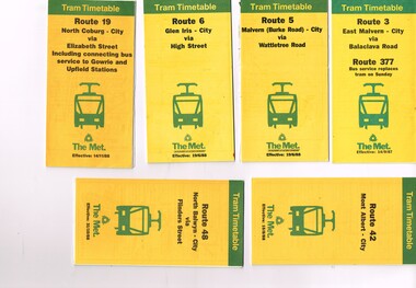
Set of 12 Tram Timetables, produced by The Met for various routes, yellow cover with a green top band, multi fold horizontal sheet, giving a route map, description, notes, time points, information contact details and types of tickets (Neighbourhood and Travelcards) and where they could be purchased. .1 - Route 3 - East Malvern - City via Balaclava Road - replaced by bus 377 on Sundays - dated 14/9/1987 .2 - Route 5 - Malvern Burke Road - City via Wattletree Road - 19/6/1988 .3 - Route 6 - Glen Iris - City via High St - 19/6/1988 .4 - Route 19 - North Coburg - City via Elizabeth St including connecting bus service to Gowrie and Upfield stations - 14/11/1988 .5 - Route 42 - Mont Albert - City - 15/8/1988 .6 - Route 48 - North Balwyn - City via Flinders St - 31/10/1988 .7 - Route 55 - West Coburg - Domain Interchange via William St - 11/2/1987 .8 - Route 57 - West Maribyrnong - City via North Melbourne - Route 357 bus replaces tram on Sunday - 27/8/1989 .9 - Route 59 - Airport West - City via Essendon - 27/8/1989 .10 - Route 64 - East Brighton - City via Hawthorn Road - 14/9/1987 .11- Route 70 - Wattle Park (Elgar Road) Princes Bridge via Swan St - 31/10/1988 .12 - Route 86 - Bundoora - City via West Preston - 15/8/1988 Full Image of .4 added 9/4/17 following a query about route 19 timetables - see image i5.trams, tramways, timetables, tickets, tram services, route 3, route 5, route 6, route 19, route 42, route 48, route 55, route 57, route 59, route 64, route 70, route 86 -
 Melbourne Tram Museum
Ephemera - Timetable/s, Public Transport Victoria (PTV), 2019
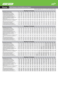
Set of 24 digital timetables generally applicable from 1-1-2019. Image files are htd3520iRx - x being the route number. Route 1 - East Coburg - South Melbourne Beach Route 3 and 3A - Melbourne University - East Malvern - and via St Kilda Beach - two timetables for each Route 5 - Melbourne University - Malvern Route 6 - Melbourne University - Glen Iris Route 11 - West Preston - Victoria Harbour Docklands Route 12 - Victoria Gardens - St Kilda Route 16 - Melbourne University - Kew Via St Kilda Route 19 - North Coburg - Flinders St Route 30 - St Vincent's Plaza - Etihad Stadium Docklands - though the stadium was renamed Marvel after Marvel comics by Disney during May 2018. Old name retained, but appears to becoming just Docklands Stadium on Yarra trams website when this item added. Route 35 - City Circle - NOT Published. Route 48 - North Balwyn - Victoria Harbour Docklands Route 55 - West Coburg - Domain Interchange Route 57 - West Maribyrnong - Flinders St Route 58 - Toorak to Route 59 - Airport West - Flinders St Route 64 - East Brighton - Melbourne University Route 67 - Carnegie - Melbourne University Route 70 - Wattle Park - Waterfront City Docklands Route 72 - Camberwell - Melbourne University Route 75 - Vermont South - Etihad Stadium Docklands Route 78 - North Richmond - Balaclava via Prahran Route 82 - Footscray - Moonee Ponds Route 86 - Bundoora RMIT - Waterfront City Docklands Route 96 - East Brunswick - St Kilda Beach Route 109 - Box Hill - Port Melbournetrams, tramways, timetables, yarra trams, route 1, route 3, route 5, route 6, route 8, route 11, route 12, route 16, route 19, route 30, route 48, route 55, route 57, route 58, route 59, route 64, route 67, route 70, route 72, route 75, route 78, route 82, route 86, route 96, route 109 -
 Ringwood and District Historical Society
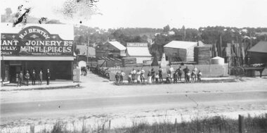
Photograph, Maroondah Highway East, Ringwood- 1920. H.J. Bently, Timber Merchant and Joinery
Black and white photograph (2 copies) Typed below one photograph: "Maroondah Highway 1920. Coffeys now on right and building on left still there (1979)" Written on rear of backing sheet: "Whitehorse Road 1920- Coffeys site- looking north. Shop now rebuilt and occupied by Lawford. Building behind 'H. J. Bentley' sign still there 1976 as part of Lawfords. Matlocks Livery Stables in background to left of 'Lime and Cement' sign. -
 City of Moorabbin Historical Society (Operating the Box Cottage Museum)
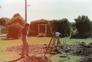
Photograph, colour 'Reconstruction Site' Feb. 1984, February 1st 1984
The original small, pioneer cottage was built in the late 1840s to early1850s, by an unknown pioneer. It was located on part of a 30 Acre allotment that was originally part of Dendy’s Special Survey granted in 1841. The doors and window sashes, (made of red deal joinery timber), as well as the brass locks and fittings, are from the original cottage, and were imported from England. The fire-place bricks are from the original cottage, and are sun-dried, (not kiln fired), and are hand-made. Convict marks can be seen on two bricks. There is a small display of external cladding shingles from the original pioneer cottage. These shingles were hand-split, and most likely made from locally collected timber The nails included in this display were used to fasten the shingles on the original cottage, and are also hand-made. The cottage was occupied by William Box and family from 1865 until 1914 when it was sold to William Reitman who resided there until 1950. The enamel nameplate, “Colonial”, on the wall of the cottage, was the name chosen for the original pioneer cottage by Mr William Reitman, when he purchased the property in around 1915, for 1200 Pounds approximately. In 1974 Mr Lewis, a timber specialist, found the dilapidated building on property he had recently purchased in Jasper Rd and suggested it be reconstructed and relocated. Moorabbin Council agreed and the cottage was rebuilt just about 250 metres from its original site. The cost of the rebuild was met by 'Victoria's 150th Committee, plus a small grant from the City of Moorabbin, and Mr Laurie Lewis donated much of the timber for the reconstruction. The re-constructed cottage plan has followed faithfully the original dimensions, and plan of the original pioneer cottage, and as many original items from that cottage’s long occupation have been incorporated. The photographs in Album 1 record the progress of the reconstruction from February 1984 to the First Public Open Day November 18th 1984These 2 photographs show the Builders Mr Moody & Mr Smith preparing the site in Joyce Park at the commencement of the 'Reconstruction in February 1984. Mrs H. Deam and Mr A. Smith, CMHS members, took these photographs to record the progress of the 'Reconstruction' from February 1984 to November 1984. Although 'Box Cottage' is a re-construction, it is an unique museum that, being located in the midst of a modern community in Ormond Victoria, can educate and demonstrate many aspects of the early settler’s way of life in Victoria. As such, it is an invaluable resource for students and all kinds of visitors. The Business card of the Builders is now 30years old2 x colour photographs of work beginning on the reconstruction of Box Cottage in Joyce Park February 1984 and 1 business card of the Builders, Moody & SmithPhotographs Back : a) 1-2-84 / Box Cottage / Mr Moody & Mr Smith ; b) 1st Day 1st Feb 1984 / Box Cottage Card Front : Centre ; Moody & Smith / BUILDERS / Left ; 8 Worthing Rd / HIGHETT 3190 / MELBOURNE / TEL 95-1463 / BUS. & PRIVATE Right ; 7 North Ct. / HIGHETT 3190 / MELBOURNE / TEL 95-5310 / BUS. & PRIVATEbrighton, moorabbin, cottages, pioneers, ormond, colonial, mckinnon, dendy henry, box william, box elizabeth, reitman william, convicts lewis timber co. ltd., deam h, museums, box alonzo -
 Mont De Lancey
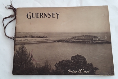
Booklet, The Star and Gazette Company Ltd, The Bailiwick of Guernsey, 1921
A historical descriptive booklet describing the charms and amenities of the wonderful island of Guernsey and all it has to offer. It includes archaeology, schools and colleges, churches, yachting, agriculture, sports, the growing industry. It has small sections on Alderney and Sark.A slim rectangular brown toned softcover booklet with Guernsey printed in black lettering at the top of the front cover and Price 6d. net printed in white lettering at the bottom right. The front and back covers depict a large overall scene of Guernsey from the land looking over the water. The Bailiwick of Guernsey: (The Islands of Guernsey, Alderney and Sark) is printed on the title page with a sepia coloured photograph of the reception of their majesties the King and Queen, and Princess Mary on the occasion of their visit, July11, 1921. There are many black and white photographs throughout the booklet. It has brown thin cord tied on the spine. 24p.non-fictionA historical descriptive booklet describing the charms and amenities of the wonderful island of Guernsey and all it has to offer. It includes archaeology, schools and colleges, churches, yachting, agriculture, sports, the growing industry. It has small sections on Alderney and Sark.history booklet, guernsey history -
 Ringwood and District Historical Society
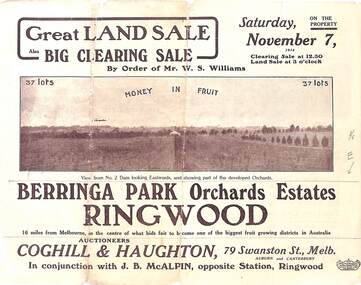
Pamphlet - Auction Sale, Berringa Park Orchards Estate, Ringwood, Victoria - 1914
Multi-fold brochure advertising public auction of 37 lots on Saturday 7th November, 1914. Brochure includes terms of sale, description of subdivision features and local facilities, and photographic images of the area. Three-page Park Orchards Estate Price List attached.Subdivison includes Smedley Road, Oban Road, Berringa Road, and Williams Road, North Ringwood. Auctioneers: Coghill & Haughton, 79 Swanston Street, Melbourne, in conjunction with J.G. McAlpin, Ringwood. Brochure includes Clearing Sale to be held same day for "everything required to work these orchards, from a packing needle to a traction engine ... comprising the most up-to-date and extensive farm & chaffcutting plant in this great district". -
 Warrnambool and District Historical Society Inc.
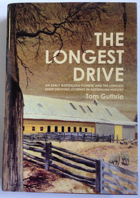
Book, Tom Guthrie, The Longest Drive, 2 McIntyre Street
Biography of Thomas Guthrie (1833-1928)This is a hardcover book of 635 pages. The dust cover is multi-coloured with an image of a painting of the woolshed at Rich Avon on the front. The book has a dark red cover.non-fictionBiography of Thomas Guthrie (1833-1928)western victoria early farming sheep farming and droving guthrie affleck, early farming sheep farming and droving guthrie affleck, droving guthrie affleck, guthrie affleck -
 Warrnambool and District Historical Society Inc.
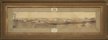
Photograph - Framed photograph of Warrnambool 1887, Town Panorama. Warrnambool Queen's Jubilee 1887, 1887
This is a framed photograph of a panoramic section of the Warrnambool township taken in 1887 to commemorate the Jubilee of the reign of Queen Victoria (1837-1887). The photograph is taken from Booval Hill (Liebig Street north) and shows the fencing in that area with groups of people in the foreground posing for the photograph. The panorama covers Liebig Street and Raglan Parade and includes private houses, a windmill and three tanks, St. John's Church, St. Joseph's Church, Tattersalls Hotel and the Saleyards.This photograph provides us with historical information on a section of the Warrnambool township in 1887 and is a valuable resource for researchers.This is a black and white photograph in a brown wooden frame and enclosed in glass. The photograph has a gilt metal edging outlined with ornate kite-shaped pieces on the corners and depicts a section of a town from an elevated position. At the top of the photograph is a crest in a shield shape and at the bottom is another shield shape containing the title of the photograph. The left centre section of the photograph is splotched or water-stained.Warrnambool Queen's Jubilee 1887warrnambool 1887, queen victoria's jubilee -
 Glen Eira Historical Society
Document - St. Stephen’s Presbyterian Church, Caulfield
Two A4 pages handwritten notes dated 23/08/2002, written by Keith Stodden regarding the Caulfield Indonesian Uniting Church, 158 Balaclava Road Caulfield North, formerly St. Stephen’s Church. Details very briefly the closure and re-opening of the church in 2001. Also included is an order of service for a service on 18/08/2012 which combined with Elsternwick Uniting Church that week to worship together. The program is written in Indonesian.stodden keith, porter ian rev. dr., caulfield, balaclava road, elsternwick, caulfield north, uniting church, presbyterian church, caulfield indonesian uniting church, st. john’s presbyterian church, elsternwick uniting church, st. stephen’s uniting church, st. stephen’s presbyterian church, religious ceremonies, religious groups, stained glass, events and activities, programs, religious structures an d establishments, languages, ethnic communities, indonesian community -
 Eltham District Historical Society Inc
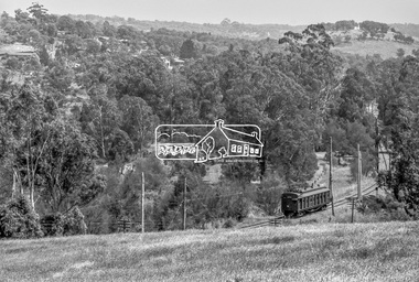
Photograph, George Coop, Single Motor Carriage (Red Rattler) Tait train, possibly 471M, heading for Eltham near Allendale Road, Diamond Creek, c.December 1980, 1980
View is looking northwest from the hillside just north of Allendale Road. The long rectangular house in the upper left is No. 22 Challenger Street, Diamond Creek, right at the sharp turn into Price Court. On the track in the straight section heading northwest are two small bridges where the track crosses the Diamond Creek, each fitted with derailment guard rails to prevent severe derailments should a train come off the tracks whilst crossing the culverts. Digital TIFF file Scan of 35mm Ilford FP4 black and white transparency471m, allendale road, challenger street, derailment guard rail, diamond creek, hurstbridge line, price court, red rattler, red rattler single carriage, single motor carriage, tait train -
 Bendigo Military Museum
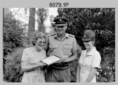
Photograph - Army Survey Regiment – Presentation to Charity Organisation, c1982
These photographs of a presentation to a charity organisation were taken in the grounds of Fortuna Villa, Army Survey Regiment in c1982. SPR Gae (Robinson) Amato was the unit’s first Miss Golden North entrant in the Miss Australia Quest. LTCOL Peter Eddy and SPR Amato presented a fundraising cheque to the unidentified representative from the Spastic Society. In later years SPR Amato took the opportunity of a new career as a commissioned officer in another Corps of the Australian Army.This is a set of four photographs of a presentation to a charity organisation at the Army Survey Regiment, Bendigo in c1982. The photographs were printed on photographic paper and are part of the Army Survey Regiment’s Collection. The photographic prints were scanned at 300 dpi, however better clarity was achieve scanning 35mm negatives at 96 dpi. .1) to .4) - Photo, black & white, c1982, L to R: unidentified charity organisation representative, LTCOL Peter Eddy, SPR Gae (Robinson) Amato..1P to .2P – No personnel identified .3P to .4P – ‘Gae Robertson MISS AUST 1980s’royal australian survey corps, rasvy, army survey regiment, army svy regt, fortuna, asr -
 Warrnambool and District Historical Society Inc.
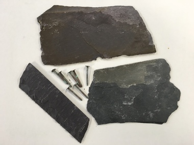
Building Marerial, Slate & Nails, mid 19th century
These slates and nails were recovered from the roof of Christ Church, Warrnambool when the slates were replaced recently. The foundations of the Anglican Christ Church in Warrnambool were laid in 1855 in Henna Street. The south nave was completed in 1857, a porch was added in 1859 and in 1862 the north nave was completed. The chancel was erected in 1877 and the tower completed in 1882. The church is a stone building. The Hammond Centre for community functions was added in the early 21st century. These items are of interest as they demonstrate the type of building materials used in the 19th century. They are also of interest as they come from a prominent building in Warrnambool, the Anglican Christ Church.These are three irregular-shaped pieces of grey slate and seven iron nails from the slate roof of Christ Church, Warrnambool. The nails have a round head and are slightly rusted. christ church warrnambool, history of warrnambool -
 Blacksmith's Cottage and Forge
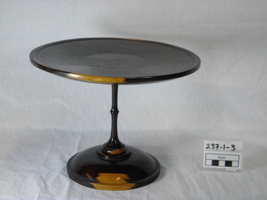
Cake Stand, Beginning of the 20th Century
This cake stand was hand turned from osage orange wood. The wood was sourced from a grove of osage orange trees in the Fisken/Taverner Street area. This grove was planted by Mr A C Simon, an orchardist, who brought the seeds from North America in the 1860's to create a protective hedge for his plants The wood from these plants produces a beautiful toned affect of dark brown and yellow/orange when turned and polished. The significance of this cake stand is that it has been carved from the osage orange which grows well in Bacchus Marsh although originated in America. Mr Simon made many items from this wood. This gives it local significance.This polished wooden stand would have been used for cake to be displayed It consists of a round 'plate' of wood as the top, with a fine narrow turned wood pedestal and a round base. The stand is made of osage orange giving it the unique tones of dark brown and orange wood.turned wood, osage orange, food stand, food display, brown orange wood, wooden, cake stand, parlour item, table centre piece, polished wood, ornamental stand -
Glen Eira Historical Society
Newspaper - DUNERA BOYS’ PORTRAITS
One item about these unidentified drawings 1/ Jenny Ling wrote ‘Dunera Boys Hunt’ article in Caulfield Port Phillip Leader of 08/09/2011. Melbourne Tour guide Shelley Cohney (of Caulfield North) is trying to track down the subjects of a series of 28 pencil portraits of ‘Dunera Boys’ and asks for assistance. The portraits were done by Theodore Engel at the Tatura internment camp and found by Shelley in a Caulfield person’s deceased estate.dunera boys, world war 1939-1945, caulfield north, internment, engel theodore, artists, ling jenny, caulfield/ port phillip press, cohney shelley, portraits, drawing, death and dying -
 Robin Boyd Foundation
Functional object - Cushion
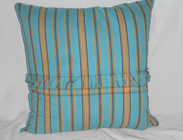
These are not original cushions in the photos by Mark Strizic in 'Living in Australia' p 83 and p129. Penleigh Boyd recalls: "the upstairs living room in the 1980s and 1990s was a much more colourful space. Arthur Boyd’s large paintings dominated the south wall and the Phillip Fox paintings as well as Tony Wood's 'In the Studio Psychologically Challenged' coloured the north wall. Patricia Boyd was experimenting with colour". These cushions were on the bed in Walsh St until around 2019.Indian cotton turquoise, rust, charcoal, mustard, beige stripe with tassels along centre. Zip on opposite side through centre square.walsh st furnishings, robin boyd -
 Robin Boyd Foundation
Functional object - Cushion
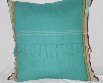
These are not original cushions in the photos by Mark Strizic in 'Living in Australia' p 83 and p129. Penleigh Boyd recalls: "the upstairs living room in the 1980s and 1990s was a much more colourful space. Arthur Boyd’s large paintings dominated the south wall and the Phillip Fox paintings as well as Tony Wood's 'In the Studio Psychologically Challenged' coloured the north wall. Patricia Boyd was experimenting with colour". These cushions were on the bed in Walsh St until around 2019.Indian cotton red, emerald green, mustard, white. Tassels and white stripes along centre. Zip on opposite side through centre square.walsh st furnishings, robin boyd -
 Sunshine and District Historical Society Incorporated
Honour Board, SPALDING 25 Years Service Roll
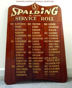
The Spalding factory was located at the intersection of Ballarat Rd and McIntyre Rd in Sunshine (North East corner). The factory made sporting goods, and in 1972 Spalding acquired T. W. Sherrin Pty Ltd which was a major manufacturer of footballs used in Australian Rules football games. In the early 1990's the factory in Sunshine was demolished and replaced by the first Bunnings Hardware store to be erected in Victoria. In July 2003 Spalding was bought out by the Russell Corporation.The board is a historical record of the loyal employees who provided at least 25 years of service to Spalding or to T. W. Sherrin Pty Ltd.Brown stained wooden board with wave shaped top which is about 14 cm less wide than the base. The names of employees who have provided 25 years of loyal service are recorded on the board in gold coloured lettering. The board contains the names of 50 workers who had reached the 25 year service milestone at SPALDING, and also the names of 4 employees who did the same at T. W. SHERRIN Pty Ltd. The first people reached this milestone in 1950 and the last person is recorded as reaching this in 1981.honour board, spalding, t. w. sherrin pty ltd, 25 years service roll -
 Whitehorse Historical Society Inc.
Photograph, Tombstone - Slater family
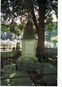
William Henry Slater emigrated from England and began growing medicinal herbs near Koonung Creek, Blackburn North in 1862. He also distilled eucalyptus oil for use at Melbourne Hospital and it was exported overseas under the 'O'Possum' brand. He later replanted his land with orchards but land taxes and rates forced the sale of the property. In 1979 the Nunawading Council purchased 7 acres of the land, now called , Slater ReserveColour photograph of the Slater family tombstone at Box Hill Cemetery. William Henry Slater died 23 May 1894 - 66 years of age Mary Ann Slater died 12 August 1912 - 83 years of ageslater, william henry, mary ann, herb farms, slater reserve -
 Ballarat Heritage Services
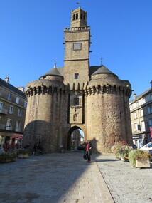
Digital Photograph, Old Gateway, Vire, France, October 2016
The Old Gateway or the Saint-Sauveur Gateway (13th Century). After the old regime it had, for some time, served as a Town Hall. In august 1944, the US troops, eager to facilitate truck traffic provisioning the frontline, wanted to blow up this tower. It was saved by the energetic intervention of Mayor Andre Halbout. The town plan of 1946 rerouted Chaussee Street, which now passes to the north of the tower. The south tower, its twin, disappeared in 1788.Colour photograph of the Old Gateway, Vire, Franceold gateway, vire, france -
 Ballarat RSL Sub-Branch Inc.
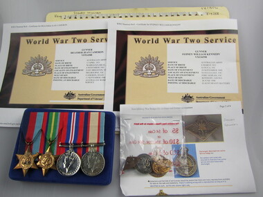
1939 - 1945 Star
This object relates to William Joseph BENTLEY. He was born on 1/07/1885 in Talbot, VIC. William Joseph served in the AIF (1111 / 1162) enlisting on, 05/10/1914 in North Melbourne, VIC before being killed during service with the 8th BATTN Ist REINF as a Army Non-Commissioned Private (PTE) on 16/09/1916. William Joseph BENTLEY was not a prisoner of war. His next of kin is Eliza BENTLEY (Mother).second world war (ww2), 1939 - 1945, medals, ballarat rsl, ballarat -
 Ballarat RSL Sub-Branch Inc.
Certificate of Service
This object relates to James Tennyson BENTLEY. He was born on 05/01/1927 in South Yarra, VIC. James Tennyson served in the Army (VX96171) enlisting on, 23/01/1945 in North Melbourne, VIC before being discharged from duties with the 21 ARMY ORDNANCE DEPOT as a Army Non-Commissioned Private (PTE) on 12/12/1947. James Tennyson BENTLEY was not a prisoner of war. His next of kin is Christina BENTLEY.second world war (ww2), 1939 - 1945, literature, ballarat rsl, ballarat -
 8th/13th Victorian Mounted Rifles Regimental Collection
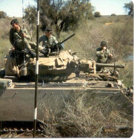
Photograph - Born digital image
A region on the Lachlan River flood plain north of Booligal New South Wales with its lightly timbered grassland criss-crossed with numerous flowing channels and water filled billabongs provided a challenging training area for a unit equipped with M113 family of vehicles. A Squadron 8/13 VMR deployed there in September 1985 for its annual exercise. The MRV was from 3 Troop commanded by Corporal RAC (Bob) MacDonald of Wangaratta Victoria. Army Reserve training in challenging countryColour image of M113 Medium Reconnaissance Vehicle(MRV) of A Squadron 8/13 Victorian Mounted rifles on annual exercise in Booligal region NSW, 1985.booligal, annual exercise, 8/13 victorian mounted rifles -
 Ballarat Tramway Museum
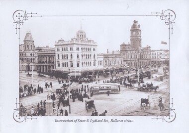
Photograph - Black & White Photograph/s, Intersection of Sturt & Lydiard Sts Ballarat, c1907
Titled "Intersection of Sturt and Lydiard Streets, Ballarat circa:." shows an ESCO tram, without windows turning from Sturt St into Lydiard St North with many people lining the streets prior to a parade. Has a number of horse drawn vehicles in photo taken from the Post Office or Summerscales Office. In photo are Craigs Hotel, National Mutual Life building and the Town Hall. See item 8247 for a colour postcard of this image. Yields information about Sturt and Lydiard St during an event.Black and white historic photograph downloaded from a picture resource website within a decorative frame and printed with an inkjet printer. trams, tramways, sturt st, lydiard st, town hall, esco -
 Ballarat Tramway Museum
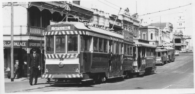
Photograph - Tram 39 and others - Lydiard St Nth, 21-8-1971
Black and white photograph of tram 39 showing Special and three other trams waiting on the tracks at Lydiard St North, most likely for a train arrival and then a tour of the Ballarat Tramway system. Photographer unknown. A Cook Tours database that the tour by the ARHS and TMSV using trams 11, 26, 39 and 42 and was a farewelll tour, with the first of the Ballarat tram lines closing the following day. See also item 7520 for other photographs.Yields information about the arrangements for tram tours using Lydiard St North.Black and white photograph on plain paper.trams, tramways, tours, tram 39, lydiard st north -
 Ballarat Tramway Museum
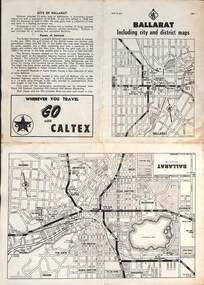
Map, RACV - Royal Automobile Club of Victoria, "Ballarat including city and district maps", 10/1961
Shows the central part of Ballarat, Ballarat Outlets, streets, principal attractions, Ballarat and district maps and information. Has the tram lines shown dotted, does not run out to Sebastopol or the Lydiard St North terminus. Each map in the bottom left-hand corner has the number "1061", possibly indicating the date. Has notes on the City, points of interest, and an advertisement for Caltex. See item 4929 for a larger version dated 1966. Yields information about the extent of Ballarat in the early 1960's shows the tram lines and other rail lines in the district. Four fold map printed on white paper, titled "Ballarat including city and district maps" - Map No. MAP 15.314 and dated 10-61. Produced by the RACVmap, tranways, ballarat, racv, railways -
 Ballarat Tramway Museum
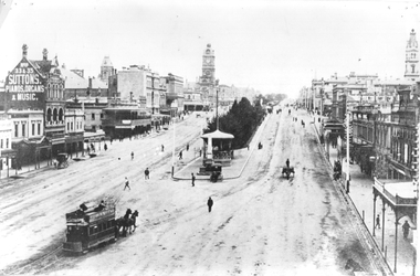
Photograph - Horse Trams Sturt St at Grenville St, c1904
Photograph shows a horse tram leaving the Grenville St terminus to travel on the north side of Sturt St. Photo from the top of the Nicholl and Allan building. In the background are many pedestrians and one horse drawn car. There is a telegraph/telephone pole line on the right hand side of the photo. See items 5103 for a close up reproduction photo of the horse tram, 836 for a black and white reproduction and 2437 for a coloured postcard of the same image.Yields information about Sturt St c1904 and horse trams.Black and white photograph on plain paperhas "3" in a circle and "4" crossed out on the rear.tramcars, trams, horse trams, sturt st, postcards, grenville st. -
 Ballarat Tramway Museum
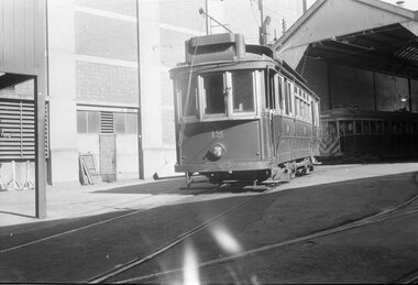
Negative - Tram 19 at Geelong Depot, Laurie Gallop, early 1956
Photo shows Tram 19 at Geelong Depot One of a set of photos was taken between 15/2/1956 and 3/3/1956 when services operated only between Belmont and North before the final closure of the Belmont route on 25/31956 and that bogie tram 31 is not shown on the board, having gone to Ballarat on 15/2/1956 - see item 5554. See item 8213 for an article on the Geelong system by Keith Kings. Yields information about the Geelong operations toward the closure of the tram system.Black and white Negative - 120 sizetramways, geelong, geelong depot, tram 19 -
 Melbourne Tram Museum
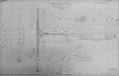
Drawing - Digtial image, Melbourne & Metropolitan Tramways Board (MMTB), "Plan and Longitudinal sections of Howard Street Siding", 2/1925
Digital image of a drawing for the access tracks to the Howard St car house or cable tram depot from Victoria St. Shows the plan and longitudinal sections. Prepared 23/2/1925 and signed by Mr Strickland Chief Engineer on 25/2/1925. This depot was made necessary by the construction of electric tram tracks in Flemington Road in 1925 which resulted in the closure of the Flemington Road car house near Racecourse Road North Melbourne.Yields information about the access track from Victoria St to the Howard St car house. Digital image of drawing P1613, "Plan and Longitudinal sections of Howard Street Siding".m&mtb, drawings, howard st, cable trams, car houses, depots -
 Ballarat Tramway Museum
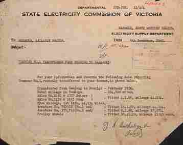
Letter, State Electricity Commission of Victoria (SECV), "Tramcar No. 1 transferred from Bendigo to Ballarat", 9/11/1960
Memo dated 9/11/1960 to the Manager of Ballarat Branch from Manager North Western Region (Bendigo) giving details of Bendigo tram No. 1 transferred to Ballarat. Gives history, mileages, axle numbers, tyre mileage, armatures, and trolley wheels, including fitting date. The tram became Ballarat 37 (the second one) and is now at the Sydney Tramway Museum. Signed by Mr Sutherland. See item 5549 for dates of transfer.Yields information about Bendigo No. 1 when it was transferred to Ballarat during October 1960Memo on SECV letterhead, typed with handwritten signatures and receipt stamp.tramways, ballarat, reports, secv, tram 1, tram 37, bendigo, tramcars -
 Flagstaff Hill Maritime Museum and Village
Photograph - Glass plate, circa 1866
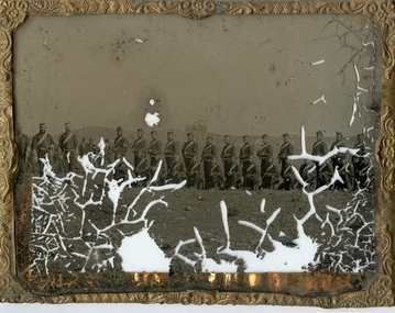
This glass plate photograph shows good detail of members of the Warrnambool Garrison posing for their photograph in front of a young township. There are other well-dressed citizens behind them. The three men with frogging on their sleeves were commanders were likely to be commanders. The men are facing north with Cannon Hill and the fortification area in the background. It dates from the 1860s. The firearms held appear to be 1853 pattern Lee Enfield muskets used by the British army in Crimea at this time and in Australia, rather than the later Martini Henry cartridge rifles. The uniforms match other photos of the Warrnambool Garrison Militia and Band in our Collection, taken up until the 1880s. The three storey building in the photograph is likely to be the Manifold & Bostock flour mill, built in 1854 near the ‘cutting’ in Merri Street, which was one of the main streets at the time; if one faced the building’s front from a vantage point and looked south to south-east, the hills around Flagstaff Hill and Cannon Hill would be behind that mill, and the Harbour behind the hills. This is the area of the Fortifications. The glass plate method of photography was widely used during the mid-19th to early-20th century. The donor and maker of the photograph are unknown. Around this time the citizens of Victoria were prospering from the gold rush but felt isolated and uneasy about their security in the colony. In 1854 the Volunteer Act was passed to provide some military defence. In 1858 the Warrnambool Volunteer Rifle Corps was established, disbanded in 1863, then a new Warrnambool Detachment was formed in September 1866. Legislation was passed in 1884 that replaced the volunteers’ corps with a partly paid, permanent Militia Defence Force. The batteries manning the coastal forts of Victoria were termed Garrison Artillery Companies. When the Army was federated in 1901 there were eight Militia Companies in Victoria. Warrnambool and Port Fairy together were known as 8 Coy AGA (Australian Garrison Artillery). Changes to formation and name continued into the 20th century.This photograph is a record of the very early local defence force, circa 1866. The photograph signifies the connection of the colony in Victoria to the growing need for security due to the unrest in Europe at that time. The photograph is also locally significant to the industry of the young township of Warrnambool, showing what is likely to be one of the first flour mills in the town. The photograph is also the only example of the early methods of glass plate photography in our collection. Photograph, rectangular glass plate, positive sepia image. Photograph has brass framed edges that fold over to the back, with mitred corners. The front edges are pressed with a decorative floral pattern. The photograph shows a group of thirty military men, standing or kneeling, in dark uniforms with pillbox forage caps, round-collared jackets with light buttons, light sashes worn from top left shoulder to bottom right side of waist belt, and long, straight-legged trousers. Three of these men have light braid around the buttons on the front of their jackets, light frogging on their sleeve cuffs and stripes on the outside seams of their trousers. The other twenty-seven men have plain uniforms and are holding firearms in their right hands, steadied with their left hands. Other figures are standing behind this group of soldiers, including three or four men wearing top hats, jackets and ties. In the background is a row of buildings. The central building is three stories high. Bare hills are in the far background. The foreground is uneven ground with patches of short grass. Photographer looking towards the south east and Cannon Hill, with the Warrnambool Garrison facing north, ca.1860s.flagstaff hill, warrnambool, shipwrecked coast, flagstaff hill maritime museum, maritime museum, shipwreck coast, flagstaff hill maritime village, great ocean road, glass plate, photography 19th century, colonial forces, military defence, volunteer act 1854, volunteer rifle, garrison artillery, volunteer corps, militia, militia garrison band, pillbox forage caps, helpmann, manifold and bostock, 1853 lee enfield musket, tintype, warrnambool garrison, 1860s, cannon hill, manifold & bostock, flour mill, 3-storey building