Showing 1861 items matching " building construction"
-
 Kiewa Valley Historical Society
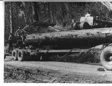
Photograph, logging at McKay Creek, Logging at McKay Creek, 1949/50
This photo was most likely taken at the site of the proposed McKay Creek Power Station. Excavation of this site was commenced in 1951 but an access road (a rough, narrow track) was put it in 1948 and widened in 1954. The State Electricity Commission would have milled logs from this area at their mill at Howman's Gap. The timber was used for building of housing and camps and provided a much needed resource as there was a general shortage of this commodity. The power station was relocated underground owing to repeated problems with landslides in the area. Restricted financial resources and the repositioning of the power station retarded construction activities and it was not completed until early 1961. An historical pictorial record of the type of machinery used in the 1950's - logging truck with bogie attached, the bull dozer and winch for hauling logs to the truck and note the lack of protective clothing!Black and white photograph showing a logging truck, bogie and bull dozer with winch for hauling the logs to the truck. Two men are on the truck, a driver on the bull dozer and a large log on the bogie. Hand written on the back of photo "Logging at McKay Creek".logging, mckay creek, timber, machinery -
 Kiewa Valley Historical Society
Photograph of Howmans Dam Camp, Howmans Dam Camp, circa 1948
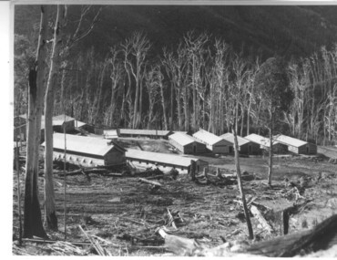
Howman's Gap camp was erected in 1948. The proposed dam to be built at this site was postponed in 1954 because of financial restraints imposed by the government at this time. It was to have supplied water for No. 2 Power Station at the Junction of the Pretty Valley and Rocky Valley branches of the East Kiewa River. This power station was not constructed until 2008 - 2010 and now gets it water from McKay Creek Power Station. The site of this camp is now occupied by the Howman's Gap Alpine Centre. Some of the original buildings still remain. An excellent photographic record of the type of buildings and size of the camp for accommodation of workmen during construction of the Kiewa Hydro Electric Scheme.Black and white photograph of the buildings erected at Howmans Dam site as accommodation for workmen.Handwritten in blue ink on the back of photograph "Howmans Dam Camp"howman's gap, camp, water, dam -
 Kiewa Valley Historical Society
Book - Reference S.E.C. History x4, Brown Power A Jubilee History of the State Electricity Commission of Victoria, first published 1969
Although this book revolves around the supply of power(Electricity) from brown coal it does cover the period 1937 onwards when the Kiewa Hydro Electricity Scheme was first mooted. This area was believed to be far away from aerial bombardment should the coastal power stations be attacked by air in World War II(1939 -1945). After the war, post 1945, the demand for a continual power supply, not affected by seasonal coastal flooding was together with a lower cost of hydro electricity power the major incentive for the Victoria Government of the day to proceed (in the 1940s) with The Kiewa Hydro Electricity Scheme. In 1946 Victorian government sought greater independence from the New South Wales black coal supplies.The significance of this book to the Kiewa Valley and its outlying regions is that it details why the development of an Alpine region was and now still is pocketed with a European flavour both in buildings and in town vegetation(trees and flowers). European (post World War II refugees) where attracted to these alpine areas not only for hard labouring positions but also for their technical skills and some street names offer a distinct European lineage rather than convict or of earlier English settler. The construction phase accommodation continued after completion of the Kiewa Hydro Electricity Scheme to become popular venues for an increasing winter tourism industry. This book has a brown hard cover encapsulated by a cream sleeve with brown and black print. On the front of the sleeve is an embossed circular motif with centre piece S.E.C. emblem and around this the words "50 YEARS OF SERVICE" and below this" STATE ELECTRICITY COMMISSION OF VICTORIA". The book contains 313 double sided pages of black print and black and white photographs.On front of paper sleeve "Brown Power A Jubilee History of the State Electricity Commission of Victoria Cecil Edwards". On the second page, below the Title "Brown Power" there is a pasted, printed presentation certificate, with the S.E.C. emblem and these printed words " Presented by the Chairman and Commissioners to A.G. MILLIST, ESQ. in recognition of long and valued service with the Commission"electricity, victorian power supplies, hydro electricity, brown coal, cecil edwards -
 Kiewa Valley Historical Society
Photograph of Pretty Valley Workers Camp*, Pretty Valley Camp, circa 1949
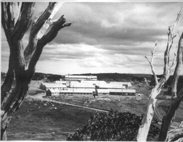
Erection of staff quarters at Pretty Valley was completed in April, 1947 and accommodation for construction workers commenced in 1948 but suspended on 11th May for winter and resumed on 9th November. Construction of this camp was completed in 1949. A large dam was proposed at this site but was never constructed. Instead a small diversion dam was built which diverts water either to Rocky Valley Dam or to McKay Creek Power Station.An historical record of the type of accommodation provided for workmen during the construction of the Kiewa Hydro Scheme during the 1940's/50's.A black and white photograph of Pretty Valley Camp, c 1949. Dead trees are in the foreground, on both the left and right side of the photograph and a small snow gum is evident. There are camp huts and a much larger building behind these, possibly a workshop, and power poles are evident bringing electricity to the site.Handwritten in blue ink on back of photograph "Pretty Valley Camp. 5600 ft. above sea level".pretty valley, dam, water, workmen, camp -
 Eltham District Historical Society Inc
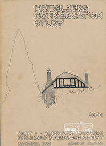
Book, Graem Butler, Heidelberg Conservation Study, Part 1 Heidelberg Historic Buildings and Areas Assessment by Graeme Butler, November 1985
Historic Buildings and Areas Assessment by Graeme Butler. Part 1 of award winning study carried out in 1982 in collaboration with a community advisory committee to Heidelberg City Council. Pioneering identification of a broad range of heritage assets varying from buildings, gravestones, farm structures, landscape areas, mileposts, divided street construction, in a time when buildings only were assessed in municipal studies.2 v. : ill., maps ; 29 cm.significant buildings heidelberg victoria, history development of heidelberg victoria, man-made landscape heidelberg victoria, significant precincts heidelberg victoria, conservation study, graeme butler -
 Eltham District Historical Society Inc
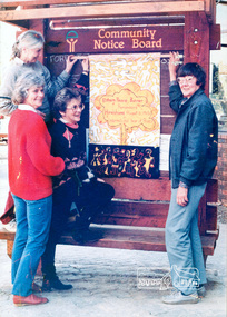
Photograph, Ron Grant, The Eltham Peace Group hanging the Hiroshima Day Banner on the Community Notice Board, Arthur Street, Eltham; Community Arts 1986 'As We Are' Banner Project Group, Hiroshima Day, 6 August 1986
Arthur Street, Eltham next to ANZ Bank The Hiroshima Day Banner was made by Jacky Talbot as part of the project. The women wanted to do something for Hiroshima Day and suggested that a workshop be set aside to make a banner. The artist was concerned about the remaining time scheduled for the project and spent several days "whipping" up the banner herself. For the artist this banner was to prove quite significant. The women hung it at the Community Notice Board on Hiroshima Day and were photographed by the local newspaper publicising the group and drawing wider community attention to the remembrance of the day. Although no new members joined the group from this activity, the artist felt that she was more fully accepted by the group afterwards. This banner has initiated a small group of women committed to peace. The artist has also continued to liaise and meet with the women as time permits. Future group plans include: making kimonos to wear when carrying the banner, participating in the Palm Sunday March, an observance of Hiroshima Day activity, which is yet to be decided, establishing contact with a sister-town in USA and USSR and supporting Eltham Council's stance as a Nuclear Free Zone. (The banner habits of the Eltham tribes : Eltham Shire "as we are" Community Banner Project report / by Jacky Talbot, Shire of Eltham, Feb. 1987, p46) Used in Shire of Eltham display at the Eltham Community Festival, 7 November 1987. Shire of Eltham Engineering Department Providing the resources to undertake • Survey, design, consultation • Road construction and maintenance • Bridge construction and maintenance • Street sweeping • Drain and pit cleaning • Traffic engineering installation and maintenance • Garbage collection • Tip management, land reclamation and beautification • Maintenance of community buildings • Provision of community and recreation facilitiesIllustrative of services provided by former Shire of ElthamColour photograph 20 x 29 cm mounted on green-painted chipboard 28 x 35.5 cm (string on back for hanging) Ref: 01842-0Title printed on label adhered to board below photograph (replaced June 2017)display panel, eltham festival, eltham peace banner, hiroshima day banner, infrastructure, shire of eltham, laurel eckersall, anne laurence, betty johnson, joan maclagan -
 Eltham District Historical Society Inc
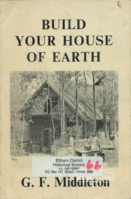
Book, George Frederick Middleton, Build your house of earth : a manual of earth wall construction / G.F. Middleton, 1979
... in the 1950s" buildings mudbrick mud brick construction ISBN 0908136722 ..."This book was "the bible" of mud brick and Pise builders in the 1950s"Paperback; xiii, 130 p., [8] p. of plates : ill. (some col.), diagrs., plans ; 25 cm.ISBN 0908136722 (pbk.)buildings, mudbrick, mud brick construction -
 Eltham District Historical Society Inc
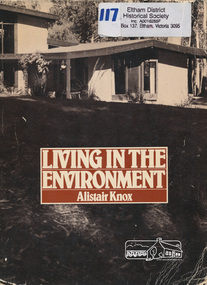
Book, Alistair Knox 1912-1986, Living in the environment / Alistair Knox, 1978
... melbourne First published in 1975 houses buildings mudbrick mud ...First published in 1975Paperback; 150 pages : illustrations ; 24 cm.ISBN 090813648X [written on flyleaf] To Norma Travis(?) from Alistair Knox 2/12/78houses, buildings, mudbrick, mud brick construction, alistair knox -
 Eltham District Historical Society Inc
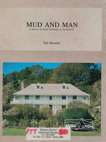
Book, Earthbuild, Mud and Man: a history of earth buildings in Australia by Ted Howard, 1992
Includes references to local sites Bear's Castle, Yan Yean (City of Whitlesea), mud brick houses in Eltham, including at Montsalvat and Eltham Community Centre, Smith's Gully, Plenty Baptist Church and Warrandyte. Includes chapter on Alistair Knox. The author's own home appears in the book on page 100. It was situated at Batman Road, Eltham next to the manse and church opposite Stanley Avenue. It was demolished for unit development June 2004 after the author's death in 2003. A significant and oft cited history of the mud brick earth construction style of architecture which includes a number of examples within the Shire of Nillumbik, known to be a site of the environmental earth building movement following WW2.198 p. : ill. (some col.), maps ISBN 0646069624earth construction, mud bricks, pise, domestic architecture -
 Eltham District Historical Society Inc
Photograph, Ruth H. Pendavingh, Building of the new Coles store at the corner of Main Road and Arthur Street, Eltham, 1999, 1999
... melbourne eltham coles store arthur street construction buildings ...Four colour photographs showing construction of the Coles store in Arthur streeteltham, coles store, arthur street, construction, buildings -
 Eltham District Historical Society Inc
Photograph, Sherbourne Primary School, Outlook Crescent, Briar Hill, c.1971-1972, 1971-1972c
... hill buildings construction Two black and white photographs ...Two black and white photographs; one internal and one external showing construction at bricklaying stagesherbourne primary school, schools, outlook crescent, briar hill, buildings, construction -
 Eltham District Historical Society Inc
Photograph, Earthworks for construction of Safeway Store, Arthur Street, Eltham
... melbourne eltham arthur street safeway store buildings construction ...Colour photograph of the earthworks undertaken in the construction of the Safeway store in Arthur Street, Eltham looking north-east.eltham, arthur street, safeway store, buildings, construction -
 Eltham District Historical Society Inc
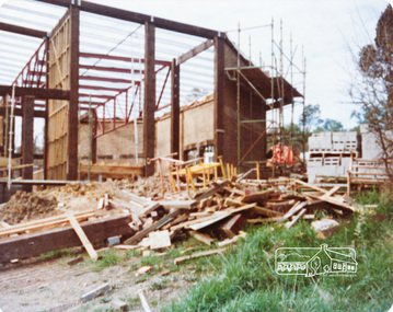
Photograph, Peter Bassett-Smith, Construction of Eltham Community Centre, June 1977, 1977
... melbourne eltham eltham community centre buildings construction ...The valley of Diamond Creek from Bridge Street looking south to Eltham Community Centreeltham, eltham community centre, buildings, construction -
 Eltham District Historical Society Inc
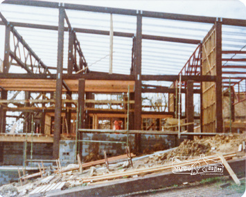
Photograph, Peter Bassett-Smith, Construction of Eltham Community Centre, June 1977, 1977
... melbourne eltham eltham community centre buildings construction ...Three colour photographs: 1. Eltham Community Centre, Pitt Street, looking south 2. Eltham Community Centre, Pitt Street, looking south 3. Eltham Community Centre, Pitt Street, looking north; oregon uprights and mudbrick wallseltham, eltham community centre, buildings, construction -
 Eltham District Historical Society Inc
Photograph, Peter Bassett-Smith, Construction of Eltham Community Centre, June 1977, 1977
... melbourne eltham eltham community centre buildings construction Two ...Two colour photographs: 1. Eltham Community Centre, Pitt Street, looking north 2. Eltham Community Centre, Pitt Street, looking northeltham, eltham community centre, buildings, construction -
 Eltham District Historical Society Inc
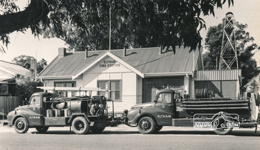
Photograph, Hugh Fisher, Eltham Fire Station, east side of Main Road, 1950s, 1950s
The Eltham Fire Station was opened in 31 April 1935. Years later the building was removed and erected for use of 1st Research Scout Group in Research Park by the early 1970s to make way for the Eltham Village Complex which was under construction by 1971. The Research Scout Hall was destroyed by fire in 2002.Black and white photographPhoto by Hugh Fischer, c.1950seltham, fire station, main road -
 Warrnambool and District Historical Society Inc.
Document - Aquarium Information sheet, Circa 1971
The information on this document shows the inspiration and planning for the building of the aquarium at the Warrnambool breakwater. The instigator was Mr. John Doull, builders Fotheringham Constructions and architects, B. Auty and D Jenner. The Aquarium was opened in December 1971 by The Hon Ian Smith MLA. There were four separate exhibitions and galleries listed on the document. The Aquarium closed around 1998.A local landmark in the latter part of the 20th century with the domes being easily recognized. The people involved in its construction were an important part of Warrnambool’s history.Framed document in green and white speckled wooden frame. Hand written in black on white paper. Subline is written in red.warrnambool history, warrnambool aquarium, john doull, fotheringham constructions -
 Streatham and District Historical Society
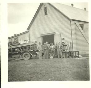
Picture, Streatham Hall
Square shaped picture of the Streatham Hall under construction. There are several workers in the photo, a truck carrying building equipment and a table with equipment on it. The men are typically dressed for the period.Stamped in green ink 399 on the back -
 Eltham District Historical Society Inc
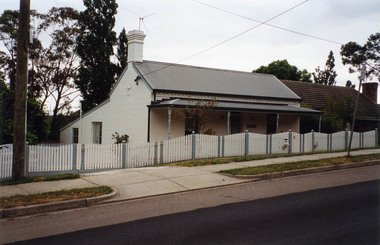
Photograph, Margaret Ball, Stebbing's Cottage, 88 Pitt Street, Eltham, June 1999
One of the oldest houses in Eltham, the cottage was built around 1861 by pioneer builder George Stebbing whose family lived in it until the 1900s. It’s plain and simple style reflects the functional design of the house. George Stebbing was responsible for the construction of some of Eltham's principal township buildings, including the Uniting (former Methodist) church, St. Margaret's Anglican church (1861) and Shillinglaw Cottage (1879). The house is historically and aesthetically significant because it is a rare surviving example of the modest homes constructed for and by artisans within the early Eltham township and is a significant feature of the streetscape In the 1960s Albert Downing owned this propertyThe Margaret Ball (Pre 1960s Houses) Collection was a personal project initiated to mark the year 2000 and arose as a result of the disappearance of many pre-1960s parts of Eltham due to development. Approximately 200 pre-1960s style houses that were left in Eltham between Main Road and east to Bible Street, between Cecil Street to the north and south to Dalton Street were photographed in late 1999. Not all of the houses could be photographed; some because the garden or trees blocked the view of the house, others because of rubbish or cars were in the way, some because people were working on the house or in the gardens at the time.Colour photographic print eltham, houses, streets, margaret ball (pre 1960s houses) collection, pitt street, stebbing's cottage, downing -
 Eltham District Historical Society Inc
Photograph, Tom Prior, Police Station and Residence, Maria Street, Eltham, c.1900
Situated near the top of what was known as 'Policeman's Hill' according to Miss Ivy Reynolds, neice of the photographer, Tom Prior. From the left, Eltham Court House, Police Residence and Police station on Main Road and corner of Brougham Street. These buildings formed part of Little Eltham and still stand (without the front fence) today though the Police Station was demolished in 1986 due to termite damage. A replica was built circa 1989. The institutions of law and order in Colonial Victoria included the police, courts and prisons. The 1852 report of the Snodgrass Select Committee appointed to "identify the policing needs of the colony” noted there existed seven independent police forces that did not co-operate or regularly communicate. Following the committee's report all these police entities were merged into the Victoria Police, founded on 8 January 1853, to implement law and order responsibilities throughout the Colony of Victoria. The Eltham Courthouse (1860) and adjacent Police Residence (1859) formed a justice precinct established in the immediate aftermath of the 1852 police inquiry and the effects of the gold rush. The physical presence of these buildings, in the centre of the early Eltham township, defined centralised control over law and order. In the early days the Police Constable in charge would conduct his duties travelling around the district by horse; a stable was located at the rear of the residence. At times the horse would be grazed on the paddocks across the road. Horseshoes were forged by the blacksmith beside the Courthouse on the high side of “Policeman’s Hill”. Along with the stable, there was a two-cell bluestone lockup where prisoners were held awaiting trial in the adjacent Courthouse. Their meals were usually provided by the policeman’s wife or from the hotel just up the road. With the arrival of the railway in 1902 the town centre gradually shifted towards the railway station. The Police Station and operations were moved into the town centre in 1961 to a renovated house in Pryor Street, which was later replaced by the current Police Station. From 1961-1981 the residence was occupied by the Vermin and Noxious Weeds Destruction Section of the Department of Crown Lands and Survey. Prior to August 1967 the former Police Station was dragged to the rear of Police Residence to make way for the construction of a driveway and access from Main Road. The building was placed on the site of a former Scullery and modified for Lands Department use. In 1981 the Shire of Eltham took over management of the former Police Residence in Eltham. It remained unoccupied for a period whilst its future was discussed in Council. It was then used for a community job creation scheme until 1985. In 1985 the Shire of Eltham Parks and Environment occupied the residence. Council improved the driveway but later added a second rear access from Brougham Street due to the dangerous nature of the Main Road entrance. Additionally, a rear toilet facility between the Police Residence and the relocated former Police Station, which was doubling up as a lunchroom. Council also commenced discussions to re-establish a replica Police Station. Around November 1986 the former Police Station was demolished; believed to have been suffering termite damage. About 1989, after some years of discussion, a replica Police Station was built, based on photographs, to act as a lunchroom and meeting room for the Parks and Environment staff and volunteers doing community service. In 1996 Eltham District Historical Society held discussions with Nillumbik Shire Council commissioners throughout the year regarding a home for the Society. A proposal was put forward by the Society in October to occupy the former Police Residence. In March 1997 Eltham District Historical Society gained access to former Police Residence and on July 12, 1998, moved into its Local History Centre. In July 2018, Eltham District Historical Society gained access to the replica Police Station (which had been used as a music library and storage for the Eltham Concert Band) for use as part of regular heritage tours for schools and community-based groups.This photo forms part of a collection of photographs gathered by the Shire of Eltham for their centenary project book,"Pioneers and Painters: 100 years of the Shire of Eltham" by Alan Marshall (1971). The collection of over 500 images is held in partnership between Eltham District Historical Society and Yarra Plenty Regional Library (Eltham Library) and is now formally known as 'The Shire of Eltham Pioneers Photograph Collection.' It is significant in being the first community sourced collection representing the places and people of the Shire's first one hundred years. The Reynolds family were early settlers in Research. The Reynolds/ Prior collection of photographs were taken by Tom Prior, the maternal uncle of Ivy Reynolds, around 1900 and the 60 photos in the album give a fine overview of many of the landmarks of Research and Eltham over 100 years ago. lvy lived in the family home for many years at 106 Thompson Cres Research. Ivy's father, Ernst Richard Reynolds and grandfather, Richard Reynolds, lived at the same address. Ivy's father Richard worked for Mr. Trail on his property in Research. Reynolds Road is named after the family. Mr Tom Prior (wife Eva) worked at the Melbourne zoo. He was very innovative and made his own camera, using the black cloth hood to exclude the light. The photographs are a reminder of the rural nature of Research and Eltham and its rich heritage.Digital imagechildren, court house, courthouse, eltham, eltham district historical society, eltham justice precinct, little eltham, local history centre, main road, police residence, police station, reynolds prior collection, sepp, shadow, shire of eltham pioneers photograph collection -
 Orbost & District Historical Society
programs, 1961
The Snowy River Shire was a local government area in the Australian Alps region of New South Wales, Australia from 1939 until May 2016. It was named after the Snowy River that runs through it. Prior to 1936, it had been named as Dalgety Shire since establishment in 1906. This opening of the Monaro - Gippsland Road took place on 4th May 1961. There had long been a movement in Monaro for the construction of a road to connect Monaro and Gippsland, via Inglebyra and Black Mountain. The only track was for stock, made by pioneers many years ago, and it was very circuitous. It was stated at a meeting at Dalgety that the road would open up large areas for settlement for grazing, and for timber suitable for bridgé building. The road would assist stock deal ing between Monaro and Gippsland. It would also considerably shorten the distance from Victoria for tourists visiting Canberra and Kosciusko. A committee was formed to put the proposal before the Dalgety Shire Council in the 1930s.This item is a useful research tool.Four copies of a road opening program. It has black print on white. There are black / white photographs, historical details and details of the official opening.program monaro-road snowy-river-shire -
 Orbost & District Historical Society
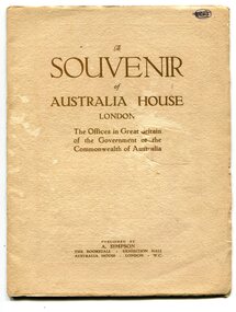
souvenir book, Souvenir of Australia House, 1920's
Australia House is the oldest Australian diplomatic mission and it is the longest continuously occupied foreign mission in London. King George V laid the building’s first foundation stone in 1913 but it was not until August 1918 that he officially opened the completed building. The stringencies of World War I – principally shipping difficulties and labour shortages – had delayed construction considerably. Federation of the six Australian states formally took place on 1 January 1901 but it was not until 1906 that the Federal Government sent an Official Secretary to London to represent Australia. In the intervening years Australia was represented by State Agents-General, the first of whom was the Agent-General of Victoria. The building is significant for its unique design, Beaux Arts style and the materials used in its construction. In the early 1900s black marble was being mined in the Bruthen district. Some was used for the Shrine of Remembrance in Melbourne and Australia House in London. 900 tonnes were shipped to London to be included in the construction of Australia House. This item is a useful research tool.A paper covered booklet which is a pictorial souvenir Of Australia House in London. Pictures show Buchan marble features of the building.buchan-marble australia-house -
 Ringwood and District Historical Society
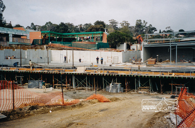
Photographs, Construction Stage of historical Miner's Cottage Museum completed 1983, and panoramic view of partial construction of commercial buildings on former Ringwood Market site, Seymour Street, Ringwood c.1970s. On cardboard
... panoramic view of partial construction of commercial buildings... construction of commercial buildings on former Ringwood Market site ...3964/1 15 photographs on cardboard 76cmX51cm depicting construction stages of historical Miner's Cottage Museum completed 1983; 3964/2 4 photographs on cardboard 85.5cmX22.5cm forming panoramic view of partial construction of commercial buildings on former Ringwood Market site, Seymour Street, Ringwood c.1970s -
 Ringwood and District Historical Society
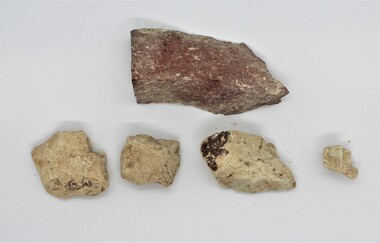
Geological specimen - Rock fragments, Five rock fragments showing reference no.141484198821 - parts of Eastland excavation in November 2014
Rock fragments excavated during construction work on Eastland shopping centre extensions.Five rock fragments showing reference no.141484198821 - parts of Eastland excavation in November 2014 donated by Terry Ahern, obtained through Probuild building contractors. +Additional Keywords: Eastland / Terry Ahern / ProbuildPart of the old Eastland -
 Ringwood and District Historical Society
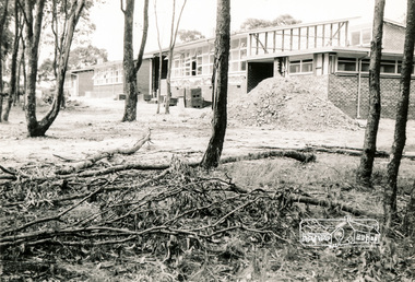
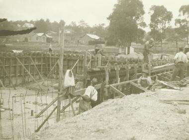
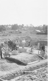
Photograph, Ringwood baths under construction, 1934
Black and white photograph (2 images)Typed below photograph, "Building old Ringwood swimming pool, 1934, Ringwood Street." -
 Ringwood and District Historical Society
Photograph, Ringwood baths under construction, 1934
Black and white photographTyped below photograph, "Building the old Ringwood baths in Ringwood Street, looking towards Reynolds Ave. 1934." -
 Ringwood and District Historical Society
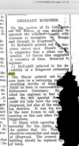
Photograph, Building the old Ringwood Baths in Ringwood St. 1934, incl Newspaper Articles
Black and white photograph. Several articles from Ringwood newspapers and the Argus (images attached) show the initial idea as Nov 1933 (3000-01 Ringwood Baths-Idea.jpg), Commencement in January 1934 (3000-02 Ringwood Baths-Start.jpg), and operational by November 1934 (3000-03 Ringwood Baths-Operational.jpg). An Argus article (via Trove) from 15 Mar 1934 describes a union complaint about use of workers on sustenance in the construction.(3000-04 Ringwood Baths-Complaint.jpg) Typed below photograph, "Building the old Ringwood Baths in Ringwood St. Looking towards Warrandyte Rd. 1934. -
 Orbost & District Historical Society
black and white photograph, late nineteenth - early 20th century
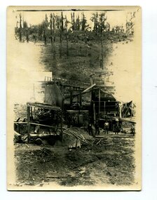
... setting. Men are standing in front of timber mine constructions... are standing in front of timber mine constructions. Some wooden ...Gold was found at Club Terrace in 1896. One of the best finds at Club Terrace was the 'Ace of Clubs' mine which was later sold to the Mallina Gold Mining Company. Syd Cadwallader was appointed manager of the company. The gold was smelted and brought to Orbost on horseback. The only protection against thieves was a revolver and riding crop, which the manager always carried. The 'Ace of Clubs' was eventually closed as the company was unable to cope with the rising water problem. (information Newsletter February 2011 - John Phillips)This is a pictorial record of mining methods in East Gippsland in the late 19th century to early 20th century.A black / white photograph of a mine. It is in a bush setting. Men are standing in front of timber mine constructions. Some wooden buildings can be seen behind the structureson back - "Cadwallader's Malina Mine"mining-gold mining-east-gippsland cadwallader-malina-mine gold-mining-battery -
 Orbost & District Historical Society
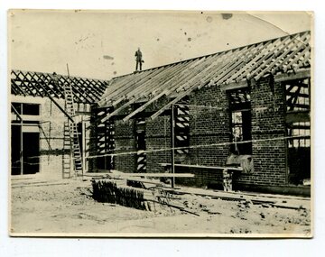
black and white photograph, 1924
This appears to be a photograph taken during the construction of Orbost High School taken on the western side.Orbost High School / Orbost Secondary College has played a significant part in the education of senior students in the Orbost district . It is the sole senior educational institution. This item is representative of its history. A black / white photograph of a partially constructed brick building. A man is standing on the roof. There is a ladder leaning against a wall on the left and there are tiles on the ground.on back - "M.Gilbert 1924" -
 Ringwood and District Historical Society
Book, Bryce Raworth, Heritage Impact Assessment - 1 Bedford Road, Ringwood, Victoria. Application for permit - Proposed Redevelopment - July 2021, 2021
A4 size wire-bound book compiled by Bryce RaworthINTRODUCTION: This heritage impact assessment (HIS) was prepared at the request of the City of Maroondah, the owner of the subject property at 1 Bedford Street (sic), Ringwood. It relates to a proposal to demolish the existing shop on the site and construct a multi-storey car park incorporating a commercial tenancy at the lower levels. It reviews the significance of the existing building on the site and the contribution it makes to the surrounding streetscapes, then comments on the heritage impacts of the proposed demolition in the context of the significance of the place and broader considerations. This office has previously provided an Historical Overview of the subject site (June 2020) and this assessment draws upon that previous research and analysis. The report has been prepared by Guy Murphy and Bryce Raworth. CONCLUSION: The proposed demolition of the former Blood Brothers Store at 1 Bedford Street (sic), Ringwood and the construction of a multi-storey car park on the enlarged site will result in the loss of some significance to the Heritage Overlay. The degree of loss is moderated by the partial intactness of the store, its modest character and the loss of its original setting, as well the proposal to implement a heritage interpretation strategy for the site. When considered in the context of the broader range of urban planning considerations and broader net community benefit, the proposed development is supported with respect to heritage impacts.