Showing 10980 items matching " village"
-
 Ringwood and District Historical Society
Map - State Aerial Survey, Dandenong Ranges Area Sheet 7, Parishes of Warrandyte, Scoresby, Ringwood and Nunawading - 1956
Map of central and southern areas of Ringwood and part of Ringwood East and Heathmont compiled by Dept of Lands and Survey, July 1956, from aerial photographs and Cadastral Survey information. Subsequent coloured hand-drawn additions showing layout of a number of post-NSW Separation era proposed subdivisions that did not eventuate, including Village of Studley Estate, Township of East Kew Estate, Township of Ballyduffy Estate, Township of New Flemington Estate, Township of East Hawthorne Estate. Ringwood A4B2, 849 A4B Zone 7. Scale: 10 chains to 1 inch. Contour interval 20 feet. -
 Bendigo Historical Society Inc.
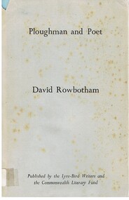
Book - ALEC H CHISHOLM COLLECTION: BOOK ''PLOUGHMAN AND POET'' BY DAVID ROWBOTHAM
Book. ALEC H CHISHOLM COLLECTION. A 47 page hardback book of poems by David Rowbotham entitled ''Ploughman and Poet''. Poems about Australia including country towns, villages, landscapes, history etc. Published by the Lyre-Bird Writers and the Commonwealth Literary Fund in 1954. Printed by Edwards & Shaw, Sydney. Catalogue sticker '2081 ROW' on spine. Handwritten in ink on flyleaf ''For Alec H Chisholm with the author's Brotherly Regards. -- David Rowbotham Toowoomba, Q. Dec. 1954''David Rowbothambooks, collections, poetry, alec h chisholm collection, poetry, david rowbotham -
 Mt Dandenong & District Historical Society Inc.
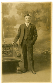
Photograph, Harry Booth, c1920s
Studio photograph of Harry Booth. A young man wearing a dark, three piece suit, collar and tie. Included in the Dorey/Woolrich collection.Black and white photograph of young Harry Booth taken in a formal studio setting. Harry Booth was the son of Jack Booth, who owned Lots 37 and 38 in the Village Settlement and had access to creek water for successful berry crops. Harry was a local market agent and travelled to Victoria Market carrying produce from local settlers.Harry carried a variety of produce by horse and cart, apparently a twenty-four hour round trip, until the business was sold in the early 1920's. Harry Booth Eden Studios Post Cardharry booth -
 Bendigo Historical Society Inc.
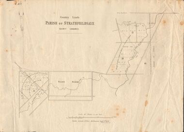
Document - MARKS COLLECTION: MAP OF PARISH OF STRATHFIELDSAYE 1858, 8th September, 1858
Buff coloured document. On top 'Country Lands, Parish of Strathfieldsaye, County Unnamed'. On bottom 'Scale 40 chains to an inch. Public Lands Office, Melbourne Sept 8th. 1858. William Collis, Lith ( lithographer )'. Map shows Village Reserve on Emu Creek, road from Sandhurst, Sheepwash Creek and Splitters Creek. Wellington Hotel marked on map near intersection of Sheepwash Creek, Axe Creek and Emu Creek. Axe Creek Pound near Splitters Creek.map, bendigo, parish of strathfieldsaye 1858 -
 Bendigo Historical Society Inc.
Ephemera - LYDIA CHANCELLOR COLLECTION: CRUISE SHIP MENU, 1963
LYDIA CHANCELLOR COLLECTION: CRUISE SHIP Menu On the front cover is a colour painted village street scene. Small print under the painting is 'Folgaria (MT, 1168) and in larger cursive script 'Sitmar Line. Inside: 'Mv. Fairsea' Saturday, April 13th, 1963 On the left page is the Luncheon menu and on the right side is the dinner menu. In the centre is a sketch of a waiter delivering drinks. on the rear is the cruise ship flag and in small print: Saiga Genova, Some small numbers and '(Printed in Italy)' -
 Falls Creek Historical Society
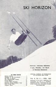
Journal - Ski-Horizon Vol 6 No 6
Ski-Horizon is the official journal of the Federation of Victorian Ski Clubs which began publication in 1949. The were 26 original member clubs which included Albury Ski Club, Bogong Ski Club, Myrtleford Ski Club, Tallangatta and District Ski Club and Wangaratta Ski Club. Two pioneers of Falls Creek, Tom Mitchell, M.L.A., and Martin Romuld were Vice-Presidents of the Federation.This Journal is significant because it documents the early development of skiing in Victoria.The journal features stories and events chronicling developments in Victoria and internationally. Items related to the Falls Creek Area in this issue include:- Cover - Rudi Wurth, winner of the National Slalom and Downhill titles at Kosciusko, 1954. Page 2 - SEC has assisted Falls Creek Village again by installing a culvert for the Creek crossing in front of the Bogong Lodge. Page 3 - SEC is considering the possibility of giving skiers more freedom of movement on the road between Mt. Beauty and Howman's Dam.bogong ski club, falls creek road access, sec falls creek -
 Melbourne Tram Museum
Document - Notice, Melbourne & Metropolitan Tramways Board (MMTB), "A Special message to all members of the Traffic Staff on the occasion of the XVIth Olympiad at Melbourne", Original 1956
Set of three colour photocopies on A4 sheets of documents issued to MMTB Traffic staff at the time of the 1956 Olympic Games in Melbourne. Titled "A Special message to all members of the Traffic Staff on the occasion of the XVIth Olympiad at Melbourne" - title page - General information page - about welcoming visitors to the city, information location, recognition of visitors - Ticket or passes - including an illustration and details of free travel badges. Also includes information on bus services to the Olympic village and sight seeing trips.trams, tramways, olympics, mmtb, tickets, passes, badges, buses -
 Melbourne Tram Museum
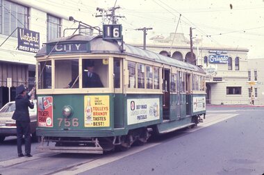
Slide, Les Fordham, Dec. 1963
hanimount light brown 35mm slides - December 1963 taken by Les Fordham of W5 756 (Route 16 City) at the Acland St, St Kilda terminus, with the conductor tying down the trolley pole, while the driver readies for the next trip. The tram has adverts fore Tiger Paw Tyres, Tolleys Brandy, Deep Image Lightest Weight Portables? In the background the Village Belle Hotel, advertising Orlando Wines and Fosters Lager and Vozdal Mens wear shop.trams, tramways, w5 class, acland st, route 16, st kilda, tram 645 -
 Flagstaff Hill Maritime Museum and Village
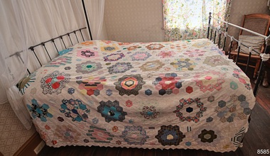
Textile - Bedspread, patchwork, 1976
This patchwork quilt or bedspread is a modern creation along the lines of the traditional 1800s handmade English paper piecing patchwork quilting craft. It is made from reproduction fabric and quilt designs and represents the bed linen typical of a late 19th-century bedroom. Years ago, patchwork was a form of recycling, where leftover or previously used pieces of fabric were used to create other useful item such as quilts, rugs, cushion covers and jackets. Special projects were sometimes made with fabrics representing special memories, such as pieces from baby clothes, wedding gowns, and school uniforms. The maker would use a cardboard template shaped like a hexagon, place it onto the fabric and trace around it. Often the cardboard was cut from a box such as a cereal box. Women would gather to work on their patchwork while enjoying their social time together. As in the case of this quilt, members of the South Western Branch of the Embroiderers Guild in Warrnambool worked on the project, designing and quilting as a group to achieve their aim, of presenting the quilt to the recently opened Flagstaff Hill Maritime Museum. It was the first Group Project of the Branch which was formed in 1974. In 1975 the members decided to make a Quilt as a project to promote the formation of friendship and togetherness. Under the foundation Treasurer, Rita Williams, members sourced their own fabrics for the 'flowers' which were then stitched into the calico borders. Provision was made for the quilt to be hung for display, with the addition of loops along one edge. The local disability services employees and members cut out octagonal paper batches and used their own fabrics to piece them together. The Branch's first exhibition raised funds for buying fabric and equipment to assemble the patchwork. The quilt was perfectly suited to dress the bed in the Lighthouse Keeper's Cottage. This carefully created and designed, recently made patchwork bedspread typifies bedding and handcraft of the late 19th century. The English paper patchwork technique was used. The quilt was the first community project of the South Western Branch of the Embroiderers' Guild of Victoria, and presented as an addition to the Lighthouse Keeper's Cottage tat Flagstaff Hill. Patchwork quilt or bedspread, double bed size, made from hundreds of hexagonal-shaped fabric of various colours and patterns, carefully stitched onto a white background. It was made using the English paper patchwork technique. One edge of the quilt has loops dispersed at regular intervals. This would allow the quit to be used as a wall hanging. It was handmade by the South Western Branch of The Embroiders Guild, Victoria, and presented to Flagstaff Hill Maritime Museum and Village in 1976. An inscription is embroidered in blue on a patch of the quilt. "Made and Presented by The Embroiderers Guild, Victoria (S.W. Branch) 1976"flagstaff hill, flagstaff hill maritime museum and village, warrnambool, maritime museum, maritime village, great ocean road, shipwreck coast, bedspread, patchwork quilt, quilt, embroiderers guild, bedding, bed linen, 1800's handcraft, quilting, south west branch, warrnambool embroiders guild, recycled fabric, 19th century, household textiles, english paper patchwork, paper patchwork technique -
 Mt Dandenong & District Historical Society Inc.
Photograph, View From Corner of Doughty's Road and Barbers Road 1913
John Lundy-Clarke grew up in the Kalorama/Mt Dandenong area and later in life (1972-74) began to write a comprehensive history of the area working from an original settlement map in an effort to cover all areas. Taken c1913, this photograph gives a clear indication of where significant buildings were located in relation to one another. Barbers Road is running through the picture with the guest house 'Kia-Ora' , built by George Barber in the centre. High on the skyline on the left is the 'Mountjoy' guesthouse, indicating the location of The Gap, or FiveWays. The small 'boxy' house above 'Kia-Ora' is 'Iona' built by the Paynter family who also built 'Mountjoy'. The Jeeves property 'Kalorama' is to the right of 'Iona' and this is the area you now look to from the FiveWays Lookout. The man in the photo is wearing a trilby hat so is probably a Rose Series employee - a feature in many Rose Series postcards.Black and white photograph that is a copy of Rose Series Postcard # 156. A man can be seen walking down an unmade road with haystacks to his right. Buildings and crops can be seen on the hillsides. Handwritten inscription on reverse by John Lundy-ClarkeView from corner of Doughty’s and Barbers Road 1913. “Kia Ora” in centre Paynter’s “Iona” near center skyline above “Kia Ora” with “Kalorama” on its right and Peter’s hut of the time below it among orchard trees. “Mountjoy” is on left skyline. W. Haye’s home is centre left. Hay paddock is Barbers Lot 25 Village Settlement.kia-ora, iona, kalorama, mountjoy, guesthouse, guest house, barbers road, doughty's road, paynter, jeeves, george barber -
 Marysville & District Historical Society
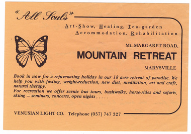
Ephemera (item) - Advertisement, MOUNTAIN RETREAT MARYSVILLE, Unknown
An advertisement for Mountain Retreat near Marysville.An advertisement for Mountain Retreat near Marysville....from Paradise Art Village, 114 Mt Margaret Rd./ Bought from "Angela" in 1985 by the/ Dowling family./ Was an artist's commune from/ about 1968-1985./ Before that was a chicken farm/ owned by the Edwards. (Parents of Betty/ Argent who lived on a 1/2 acre block just/ off from the main block with her husband,/ Charlie Argent.)marysville, victoria, australia, mountain retreat, betty argent, charlie argent, venusian light co, paradise art village, dowling family, advertisement -
 St Kilda Historical Society
Photograph
St John’s Congregational Church was established in 1888 on the corner of Barkly and Mitford Streets, near the Village Belle Hotel in South St Kilda. The building has now been demolished. The photograph was taken at the final service. The church closed in 1974 and gave its hymn books, carpets and curtains to its sister church, East St Kilda Congregational Church at the corner of Hotham and Inkerman Streets (later East St Kilda Uniting Church and now Trinity-St Nicholas Church).black and white photographPortion of ceiling of St John Cong. Church South S Kilda. Closing Service 31 Dec 1973st kilda, churches, st john's congregational church, congregational churches -
 Ithacan Historical Society
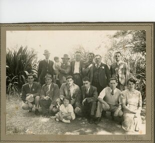
Photograph, Ithacan Picnic - Paizis families, C late 1930s
Picnic group from the early 1930's, many of whom are from the Ithacan village of Kioni. The shield shaped badge worn by those in the photo was given to all guests at the picnic. The annual picnic was an important part of the Society's social calendar. The picnic which continues to this day is an opportunity for the generations of Ithacan descendants to catch up.Black & white photograph outdoors of eleven men, one lady and two children. -
 Kiewa Valley Historical Society
Photographs –Collection of 10 copies and original black and white photographs and printed articles relating to skiing on the Bogong High Plains
After World War II, the Kiewa Hydro-Electric Scheme was started in the Kiewa River Valley by the State Electricity Commission of Victoria. On land previously used only for summer cattle grazing in the natural alpine grasslands, the first ski lodge was built in 1948 by workers from the hydro scheme as skiing was a popular recreation. Many of the hydro employees were of European background and had grown up enjoying skiing and snow sports in their homelands and were keen to continue to pursue their winter sports interests. The first lift, a rope tow, was built in 1951 at Falls Creek and the first chairlift in Australia was constructed there in 1957. Two T-Bars were opened in 1961. In 1964, the Victorian Municipal Directory recorded that Falls Creek had 29 ski club lodges and 16 commercial lodges. The area became a popular tourist destination for both winter and summer sports.: Employees of the State Electricity Commission of Victoria in the Kiewa River Valley were the earliest skiers on the Bogong High Plains and built one of the first ski lodges at Falls Creek. They were amongst those pivotal in the development of the skiing and tourist industry at Falls Creek and on the Bogong High Plains. Collection of 10 copies and original black and white photographs and printed articles relating to skiing on the Bogong High Plains. Some pieces have been enlarged to A3 poster size copies for display purposes 1. Copy of black and white photograph of group of skiers at Falls Creek 2. Copy of photograph of early skier on Bogong High Plains with temporary buildings and tents in the background 3. Copy of photograph of 3 skiers on Mt McKay 4. Copy of SECV photograph of Rocky Valley Camp under snow 5. Early sepia photograph of Falls Creek village with skiers in the foreground 6. Copy of a page from booklet (SECV?) promoting the benefits of owning a holiday home in the Bogong Village area 7. Copy of a page from booklet (SECV?) promoting the benefits of holidaying in and around Falls Creek/Mt Beauty 8. Panoramic view of ski fields with skis in the foreground 9. Photograph of young skier (identity unknown) 10. Photograph of 2 male skiers (identity unknown) performing a small jump 1. Bogong Ski Club Members & Friends 1944 2. Jack Neve – electrician. Rocky Valley 3. 17.5.55 Skiers ascending Mt McKay 4. State Electricity Commission of Victoria. Date:17.8.55 No:K8132 Kiewa Hydro Electric Works. Rocky Valley Camp – From Engineering Office 5 & 9 No markings 6 & 7 Short article relating to photos on each page 8. Handwritten signature on rear of photo (Sandra Conea) 10 Faded unreadable photographers stamp and handwritten numbers 6875 on rear secv; bogong high plains; skiers; falls creek; tourism -
 The Beechworth Burke Museum
Photograph, c. 1918
Taken in c. 1918, this photograph depicts the ruins of the French village Villers-Bretonneux. In the foreground of the image are rows of shell damaged houses and buildings. In the background of the image stands a tower of the ruined church.On 24 April, Villers-Bretonneux was captured by the Germans as they advanced towards the regional city of Amiens. If they achieved their goal and drove onto the French coast, splitting the British and French armies, the Allied cause might have been lost. The fate of Amiens hung in the balance as two Australian brigades were given the task of retaking Villers-Bretonneux through a swift night-time counter attack. One brigade would assault from the south, while another would attack from the north. The assault began at 10pm on 24 April. The 13th Brigade in the south were held up by German machine guns, before the Australians linked up east of the village. After dawn on 25 April Australian and British troops were involved in fierce fighting to clear the Germans from the village. Some Germans escaped Villers-Bretonneux through nearby woods. Later on the morning of 25 April, three years to the day after the Anzacs landings at Gallipoli, French and Australian flags were raised over Villers-Bretonneux.Black and white rectangular reproduced photograph printed on matte photographic paperReverse: (A copyright and reproduction notice from the Australian War Museum, printed upside-down in blue ink) Church x Ruins/ Villers Bretonneux/ (in pencil) burke museum, world war 1, ww1, wwi, france, australia, villers-bretonneux, ruins, military album -
 Ithacan Historical Society
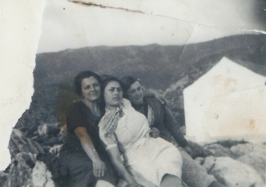
Photograph, Kalypso Sofianos nee Raftopoulos, c Early 1930s
Kalypso Sofianos nee Raftopoulos is pictured in the middle. The other women are not identified. The group were photographed in Ithaca, in the village of Kioni, possibly taken shortly before Kalypso emigrated to Australia in 1936.Young people migrating from their homeland to a foreign county and unknown culture left behind family and close friends.A scanned black and white photograph of three women sitting on a stone wall with a stone cottage visible on the RHS of the picture and mountains in the background. A portion of the original photograph was torn on the LHS. -
![Work on paper - Article, Eltham Town Community News, 9th Eltham Town Jazz & Blues Heritage Festival Success!, [2009]](/media/collectors/4f729f7b97f83e03086018a5/items/6085faba4108af46c5c4e426/item-media/6085fad54108af46c5c4e482/item-fit-380x285.jpg) Eltham District Historical Society Inc
Eltham District Historical Society IncWork on paper - Article, Eltham Town Community News, 9th Eltham Town Jazz & Blues Heritage Festival Success!, [2009]
Article by Howard Chant published in theEltham Town Community News [2009] page 13 ASlso miscellaneous advertising material opposite page (12) [reverse side of article on Judge Book Village] advertising, bunnings, eltham chambver of commerce and indiustry, eltham town jazz blues heritage festival, howard chant, la zanyas, machan indian restaurant, steve herbert mp -
 Bendigo Military Museum
Souvenir - BOAT MODELS, 1962-72
The two models were collected from small village in South Vietnam by Geoff Murray No 3411521, Vietnam 3 Cav Regt 27.11.67 to 22.10.68, Survey Corp 15.10.69 to 15.10.70. Refer 638P..1 Model of a three masted ship made entirely of bamboo, mounted on a slice of timber. .2 Model of a two storey native stilt house with a tree made of a twig and painted polystyrene. Mounted on a slice of timber.handcrafts-sailor's craft, woodwork, vietnam, models -
 Greensborough Historical Society
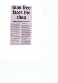
Newspaper Clipping, Diamond valley Leader, Gum tree faces the chop, 07/08/2019
Neighbours in Watsonia are dismayed a beloved tree faces the chopping block after Banyule Council agreed to accept $150,000 from an architecture firm in exchange for the towering gum at Diamond Village Shopping Centre.News article 1 page, black text.diamond village, gum tree, banyule city council, c kairouz architects -
 Falls Creek Historical Society
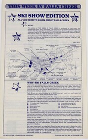
Document - This Week in Falls Creek - Ski Show Edition
This booklet is part of the Falls Creek Marketing program. If provides explanation about the location of Falls Creek Village as well as detailed information related to travel, accommodation options and other facilities and services available.This item is important as it documents seasonal activities at Falls Creek Alpine ResortPaper booklet on cream page with blue print for the This Week in Falls Creek - Ski Show Edition information booklet. accommodation falls creek, falls creek marketing -
 Charlton Golden Grains Museum Inc
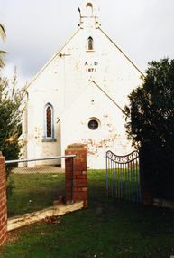
Photograph, Charlton Shire, St Andrews Charlton Presbyterian Church, c.Dec 1987
The St Andrew Charlton Presbyterian Church was built in 1871 by James Patterson, a contractor and grazier of Nardoo Park, Woosang. Dismantled in 1889 to clear area for St Andrews Village, Hall built in 1913.Colour Photo of St Andrews Presbyterian Church c.1987charlton presbyterian church, james patterson, church, presbyterian, pastoral care, manse -
 Eltham District Historical Society Inc
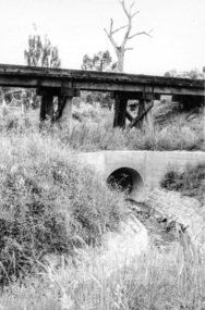
Photograph, Looking west from Main Road from just north of intersection with Diamond Street, Eltham, February 1968, Feb 1968
The watercourse passes under the road and railway at this point. Significant flash flooding occurred along this water course on Christmas Day 2011 causing significant damage to the railway line and road and flooding of Judge Book Village. The drain was swept away including the support pillars of the rail lines timber framework. Judge Book Village had some 40 units flooded before the water entered Diamond Creek. The water had flowed down and flooded Valonia Drive then Grove Street before flowing down the watercourse to Main RoadIn February 1968 an unknown person took a series of photos from the Eltham Hotel at Pitt Street heading north along Main Road through the shopping centre to just north of Elsa Court covering the length of the section of Main Road which was duplicated shortly thereafter. Shows the condition and environment of the streesscape of Main Road, Eltham immediately prior to the duplication between Pitt Street and Elsa Court through the shopping centre. Also shows a number of shops and businesses that operated at that time.Black and white photographduplication, eltham, main road, diamond street, watercourse, drainage, railway line -
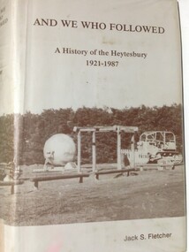 Warrnambool and District Historical Society Inc.
Book, And We Who Followed, 1988
This book contains a history of the Shire of Heytesbury from 1921 to 1987. It is written by Jack Fletcher and follows on from his book ‘The Infiltrators’ which is the history of the Heytesbury region from 1840 to 1920. The Heytesbury area in the Western District of Victoria was named after the village of Heytesbury in England and the first Baron Heytesbury, Sir William A Court, who purchased the village in 1828 and was a distinguished public figure in Great Britain at the time. The area, largely forested, was cleared in 1960 to establish the Heytesbury Soldier Settlement Scheme and is today an important dairying area centred around the town of Simpson.This book is of some interest as it details a history of an area adjoining the Warrnambool district. The Heytesbury Settlement farmers are predominantly dairy producers, similar to those in other districts around WarrnamboolThis is a hard cover buff-coloured book with a dust cover sealed down onto the hard cover. The front and back covers have a sepia coloured photograph of the Heytesbury Settlement Park.Front of dust cover – ‘And We Who Followed - A History of the Heytesbury 1921-1987-Jack S. Fletcher Spine – as above (plus a library classification) heytesbury region, victoria, heytesbury soldier settlement -
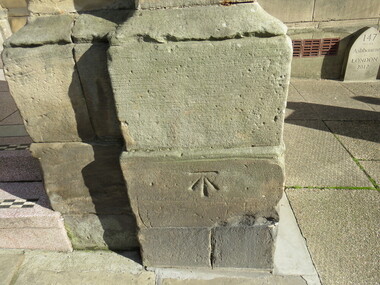 Ballarat Heritage Services
Digital Photograph, Stonemason mark, Ashbourne Town Hall, UK
Ashbourne is one of Derbyshire's fines and most vibrant market towns. It combines a wealth of historic buildings and shops. The Market Place is cobbles with hidden alleys and yards that lead to the carparks behind the main street. The wide and elegant Church Street is considered to be the finest street of Georgian buildings in Derbyshire. Tissington Hall and Village are in the nearby vicinity. Built by Francis Fitzherbert in 1609 Tissington Hall has been lived in by the Fitzherbert family ever since. The estate village has a number of micro businesses and a beautiful duck pond. Reference: Information from the Ashbourne Tourist pamphletmason marks ashbourne derbyshire market town francis fitzherbert tissington -
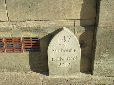 Ballarat Heritage Services
Digital Photograph, Milestone, Ashbourne, UK
Ashbourne is one of Derbyshire's fines and most vibrant market towns. It combines a wealth of historic buildings and shops. The Market Place is cobbles with hidden alleys and yards that lead to the carparks behind the main street. The wide and elegant Church Street is considered to be the finest street of Georgian buildings in Derbyshire. Tissington Hall and Village are in the nearby vicinity. Built by Francis Fitzherbert in 1609 Tissington Hall has been lived in by the Fitzherbert family ever since. The estate village has a number of micro businesses and a beautiful duck pond. Reference: Information from the Ashbourne Tourist pamphlet -
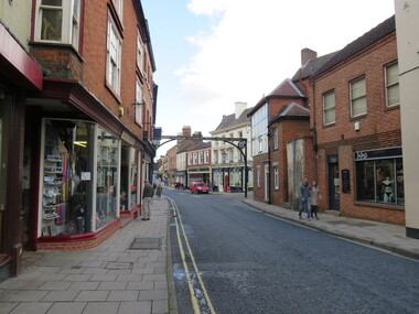 Ballarat Heritage Services
Digital photograph, Sign, Ashbourne, UK
Ashbourne is one of Derbyshire's fines and most vibrant market towns. It combines a wealth of historic buildings and shops. The Market Place is cobbles with hidden alleys and yards that lead to the carparks behind the main street. The wide and elegant Church Street is considered to be the finest street of Georgian buildings in Derbyshire. Tissington Hall and Village are in the nearby vicinity. Built by Francis Fitzherbert in 1609 Tissington Hall has been lived in by the Fitzherbert family ever since. The estate village has a number of micro businesses and a beautiful duck pond. Reference: Information from the Ashbourne Tourist pamphletGreen Man and Black's Head Royal Hotelashbourne derbyshire church st francis ftizherbert market town georgian tissington -
 Ballarat Heritage Services
Digital Photograph, Plaque, Ashbourne, UK
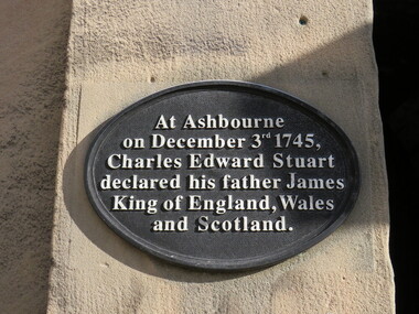
Ashbourne is one of Derbyshire's fines and most vibrant market towns. It combines a wealth of historic buildings and shops. The Market Place is cobbles with hidden alleys and yards that lead to the carparks behind the main street. The wide and elegant Church Street is considered to be the finest street of Georgian buildings in Derbyshire. Tissington Hall and Village are in the nearby vicinity. Built by Francis Fitzherbert in 1609 Tissington Hall has been lived in by the Fitzherbert family ever since. The estate village has a number of micro businesses and a beautiful duck pond. Reference: Information from the Ashbourne Tourist pamphletAt Ashbourne on December 3rd 1745, Charles Edward Stuart declared his father James King of England, Wales and Scotland.king james, ashbourne -
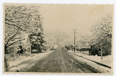 Mt Dandenong & District Historical Society Inc.
Photograph, Main Street Sassafras in Snow, c1952
The Main Street of Sassafras c1952 showing Mechanics Institute at left under snow. Note the hedge around the area that is now the Village Green. At the time of the photo the land belonged to Eva Shugg where she ran holiday flats called St Annes. Eva Shugg sold her house to Max Dower to extend his nursery in the 1970s and built a new home around the corner on Mountain Highway. At this time she donated part of her remaining land to form a Village Green. Eva Shugg lived to the age of 106 and died in 2007.Black and white photograph with serrated edge showing the Main Street of Sassafras under snow c1952. Mechanics' Institute is on LHS with cars parked outside the site of Sassafras House.On reverse written in pencil 'Main Street, Sassafras"sassafras, snow, mechanics' institute, mechanics' hall, village green, eva shugg, max dower -
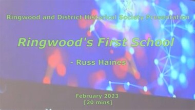 Ringwood and District Historical Society
Mixed media - Video, RDHS Meeting Presentation - "Ringwood's First School" - Russ Haines
Digitised video (894MB). Duration: 20 minutes. Recorded February, 2023 (Video is available for viewing at Ringwood & District Historical Society Archives by appointment)As a follow up to the recent centenary celebrations of the 1921 Ringwood State School building in Greenwood Avenue, Ringwood and District Historical Society President Russ Haines presents this look back at the often overlooked earlier history of the village of Ringwood, including the establishment of Cass' School in 1874 on five acres of land between Dublin Road and Everard Road, becoming Ringwood's first school. -
![Scene at Healesville / [by] Nicholas Caire, circa 1876](/media/collectors/550653872162f11fb04854aa/items/577b4f7bd0cdd10948cab12f/item-media/577b4fe9d0cdd10948caef25/item-fit-380x285.jpg) Kew Historical Society Inc
Kew Historical Society IncPhotograph, Anglo-Australasian Photographic Company, Scene at Healesville, c. 1876
Nicholas Caire was born on Guernsey in the Channel Islands in 1837. He arrived in Adelaide with his parents in about 1860. In 1867, following photographic journeys in Gippsland, he opened a studio in Adelaide. From 1870 to 1876 he lived and worked in Talbot in Central Victoria. In 1876 he purchased T. F. Chuck's studios in the Royal Arcade Melbourne. In 1885, following the introduction of dry plate photography, he began a series of landscape series, which were commercially successful. As a photographer, he travelled extensively through Victoria, photographing places few of his contemporaries had previously seen. He died in 1918. Reference: Jack Cato, 'Caire, Nicholas John (1837–1918)', Australian Dictionary of Biography.An original, rare photograph from the series 'Views of Victoria: General Series' by the photographer, Nicholas Caire (1837-1918). The series of 60 photographs that comprise the series was issued c. 1876 and reinforced a neo-Romantic view of the Australian landscape to which a growing nationalist movement would respond. Nicholas Caire was active as a photographer in Australia from 1858 until his death in 1918. His vision of the Australian bush and pioneer life had a counterpart in the works of Henry Lawson and other nationalist poets, authors and painters.Views of Victoria (General Series) No.24 / ‘Scene at Healesville’ / Albumen silver photograph mounted on cardOn Reverse: ‘After leaving the villages of Lilydale and S. Hubert the scenery commences to assume a very wild and romantic appearance. The country becomes exceedingly undulatory, and the belts of densely packed scrub, present altogether a very different appearance from the more settled and cultivated districts. Our illustration is taken from one of the many creeks which surround the rising township of Healesville.’nicholas caire (1837-1918), australia - landscape photography