Showing 3069 items matching "scales"
-
 Stawell Historical Society Inc
Map, Township of Stawell
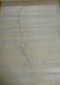
B/W map of Stawell Surveyed by Easton Johnston Contract surveyor Scale in Chains. Showing Special Allotments Reefs, Pleasant Creek Parish of Stawell. Map No L4000 -
 Bendigo Historical Society Inc.
Map - PLAN OF BENDIGO CREEK, 12th March 1873
Map: Hand drafted plan of the Bendigo Creek, covering from Scott St. White Hills to Alder St. Kangaroo Flat. Scale 2 chains to 1 inchGeorge R------- ? City Surveyormap, bendigo, bendigo creek -
University of Melbourne, Burnley Campus Archives
Plan, Plant Culture and Garden Maintenance Planting Plan Assignment, 1987-1988
(1) Plan on tracing paper of Mixed Border, plants not included, signed MG March '87. (2) Base Plan by MG, July 1988. Scale 1:100.gardens, maintenance, planting, plant culture, mixed border, victorian plant research institute, m. green -
 Bendigo Historical Society Inc.
Map - CAMPBELL COLLECTION: BENDIGO AND DISTRICT MAPS
Map. Parish of Sandhurst, Parish of Huntly, Parish of Nerring, Parish of Marong, Parish of Lockwood, Parish of Wellsford, Parish of Strathfieldsaye, Parish of Mandurang. Scale approx 1:18,000.map, bendigo, parishes -
 Mission to Seafarers Victoria
Drawing - Artist sketch, Gerry Cummins & Jill Stehn Pty. Ltd, 1980
The window in this photograph was commissioned by the Sandringham Yacht Club in conjunction with a Masonic Lodge and work carried out by Gerry Cummins in 1980. In the background is the S.S. 'Kanimbla' built 1935, Belfast for McIlwraith McEacham and was the last large passenger ship built specifically for Australian owners. Designed to carry 400 passengers , she plied her trade around the Southern and Eastern Ports of Australia. In WW2 she was an armed merchant cruiser and served in Indian waters and escorted the 1st convoy out of the Singapore after the Japanese invasion. She later operated in the Pacific after the war and after repatriation duties she was decommissioned and subsequently sold to be renamed 'Oriental Queen' which eventually caught fire and sank. . The small yacht in the foreground refers to the Sandringham YC. Window measurements: 600mm x 900mmShows the link with Freemasonry.Sketch in pencil and ink on cream paper for an arched stained glass window depicting a yacht.Bottom left corner: Proposed Stained Glass Window, Mission to Seamen. (Scale: Full Size) Right Left corner: Gerry Cummingsfreemasons, st peter chapel, flinders street, mission to seafarers, gerry cummins, jill stehn, stained glass window, sandringham yacht club, hearts of oak lodge, yacht, symbols, square, compass, ss kanimbla -
![Planning Document, Plan of proposed subdivision of land in Greensborough [Map shows Scotland house], 01/04/1971](/media/collectors/4f729f5697f83e03086015b8/items/5982a68921ea6b1420e4e560/item-media/59916fb521ea681094908d7a/item-fit-380x285.jpg) Greensborough Historical Society
Greensborough Historical SocietyPlanning Document, Plan of proposed subdivision of land in Greensborough [Map shows Scotland house], 01/04/1971
This subdivision of Greensborough shows the home of John Scotland (died 1888) and surrounding area bounded by Hailes, William, Lorimer, and Jessop Streets.Photocopy of plan, 2 pages.Part of plan (68G) of proposed subdivision of Greensborough, part of Crown Portion 18, Parish pf Keelbundora. Scale: 132 ft. to an inchjohn scotland, hailes street greensborough, william street greensborough, lorimer street greensborough, jessop street greensborough -
 Ringwood and District Historical Society
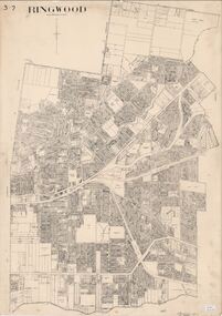
Map, City of Ringwood - Rateable Properties Layout - c.1966
A0-size (approx) map of named streets, lot-numbered properties and locality features within City of Ringwood boundary. Scale: 8 chains to 1 inch. City Engineer's signature in bottom right corner - Alan Robertson (City Engineer 1958-1987) -
 Ringwood and District Historical Society
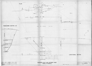
Plan - Department of Mines, Victoria, Ringwood Gold and Antimony Mine - 1921
Technical drawings of Antimony Mine - Plan view, Transverse Section view, and Longitudinal Section view. Includes Main Shaft, No.1 Level 184', No.2 Level 244', No.3 Level 304', No.4 Level 372'. Multiple copies, including copy with overlay of Civic Centre.Scale 40 feet to 1 inch. Surveyed 20-12-21. Traced 1-7-66. W-2568/B/1. -
 Ringwood and District Historical Society
Map - State Aerial Survey, Dandenong Ranges Area, Parts of Parishes of Nunawading, Warrandyte and Ringwood - 1956
Map of Ringwood North and parts of Mitcham, Donvale, Park Orchards and Ringwood East compiled by Dept of Lands and Survey, July 1956, from aerial photographs and Cadastral Survey information. Sheet 1, Ringwood A2D or 849 A2D Zone 7. Scale: 4 chains to 1 inch. Contour interval 20 feet. -
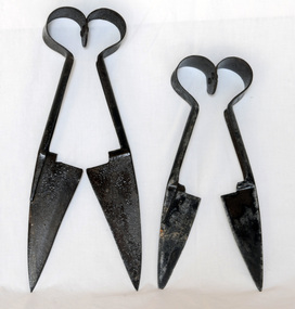 Orbost & District Historical Society
hand shears, 1950 -1955
These shears were possibly used on a small scale.The hand-shears are representative of the era of wool-growing before mechanical shears were commonly adopted.Two pairs of hand-operated blade shears. The metal shears consist of two scissor like blades with hinges at the tops of the handlesCombination T U & S No 14 Sheffieldshears hand-operated wool rural -
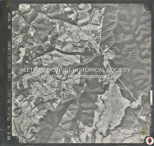 Eltham District Historical Society Inc
Photograph - Aerial Photograph, Smiths Gully, Christmas Hills, St Andrews, Kinglake National Park, 6 Mar. 1986
Small scale Red arrow indicates Northshire of eltham archives, aerial photo, christmas hills, kinglake national park, smiths gully, st andrews -
 Whitehorse Historical Society Inc.
Functional object - Letter Opener
From the Betty McPhee writing equipment collectionA bone coloured letter called a 'letter scale' with an embossed imperial scale to 7 inches on one edge. Handle has five red dots marking 1/4 oz, 1/2 oz, 1oz, 1 1/2 oz & 2oz. On reverse is inscription 'insert letter' to mark gap to weigh letter and an additional inscription 'grasp rotary button and balance'. Embossed in blue with compliments ALLEN & HANBURYSWith compliments ALLEN & HANBURYScommerce, office equipment / stationery, domestic items, writing equipment -
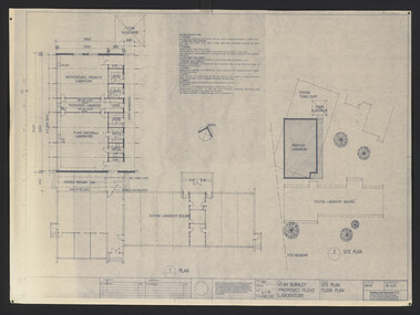 University of Melbourne, Burnley Campus Archives
Plan, VCAH Burnley Proposed Plant Laboratory, 1989
This must have been put out for tender - no information on which was used1. Site Plan Floor Plan Job No. 89038. Drawing No. SKA001 by Godfrey and Spowers Australia Pty. Ltd. Scale 1:100, 1:200 X 4. 2. Proposed Laboratories & Offices at Swan Street, Richmond for VCAH-Burnley. College of Horticulture: Floor Plan, Section A-A, Elevation 1, 2, 3 and $. Sheet No. 8952 WD2 by Fooks Martin Sandow Pty Ltd. Scale 1:100vcah, burnley, laboratory, fooks martin sandow p/l, godfrey and spowers australia p/l -
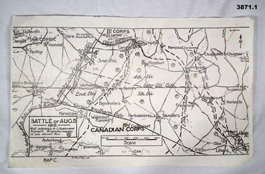 Bendigo Military Museum
Map - TRENCH, BATTLE & ORDNANCE MAPS FRANCE WW1, All 1918
(.2) Areas on map relate to : The Hindenburg line on the left, from the top, Bony to Bellicourt to Bellenglise, Estrees to Brancourt. (.3) The River Somme runs through from top corner left bottom corner right. Main areas are Belloy, Picquigny, Bertangles, Montieres. The map finishes just short of “Amiens” Items in the collection relating to F.A.W Hutson No 3539 AIF. refer Cat No 922 for his service history.(.1) Map on paper showing the “Battle of August 1918”, Map C, The Advance to “Lions & Proyart”. (.2) Trench map, gauze lined, sheet 62B N.W, trenches corrected to 8.2.1918, German trenches in blue, scale 1:20,000, France. (.3) Ordnance survey map, May 1918, France, Edition 1, sheet 62 E N.E, scale 1:20,000, a canal and river runs through the centre(.2) On rear hand written “62 B N.W” (.3) On rear hand written “D.M.F 62 E N.E”august 1918, maps, somme -
Clunes Museum
Map, Township of Clunes - Parish of Clunes - County of Talbot
Map of Clunes Township in 19511 X PHOTOCOPY OF MAP, (COMPRISING A NUMBER OF A4 SHEETS TAPED TOGETHER) SHOWING LOT NUMBERS AND NAMES OF LANDHOLDER. REFERENCE GAZ 1951.1480. SCALE 30 CHAINS = 1 INCH 1 X PHOTOCOPY OF MAP, (COMPRISING A NUMBER OF A4 SHEETS TAPED TOGETHER) SHOWING LOT NUMBERS AND NAMES OF LANDHOLDER. REFERENCE: G76359 GENERAL FILE TOWNSHIP RESIDENTIAL ALLOTMENTS SCALE 30 CHAINS = 1 INCHNOTATED IN PURPLE CRAYON ON SECOND MAP: AS AT LATE 1984 COPY OF MAP FROM LAND TITLES OFFICE BALLARATtownship of clunes map, 1951 -
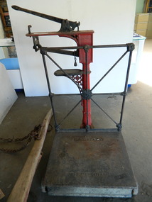 Kiewa Valley Historical Society
Scales - Tawonga Store
These scales were used in the Tawonga Store which opened c1920. They were used to weigh produce e.g.. flour & wheat that the farmers used on their farms and in their homes. These scales pre date packaging. Ref. Weights KVHS 0800 (A)The Tawonga Store opened c1920 and sold goods and produce to the farmers of the Kiewa Valley. The scales were a necessary item for a store as goods were sold in bulk. Large steel dirty black platform attached at the middle of the back to a red cylinder which has 2 smaller platforms coming out to the side. The top platform has a black steel lever attached and a hook to hold it down. Below this platform is a measuring rod marked 2,4 etc up to 14 on which hangs a eight. The bottom platform is to rest the unused weights. Weights ref. KVHS 0800 (A)W. & T. Avery Birminghamscales. weights. tawonga store. farm produce. -
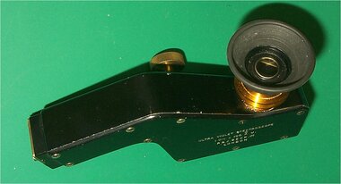 Federation University Historical Collection
Instrument - Scientific Instrument, R. & J. Beck Ltd, Ultra-Violet Spectroscope
A fluorescent screen seen with an illuminated scale shows the wavelength(s) of entering light. A Cylindrical Quartz Lens is provided to concentrate on the slit light from weak sources. The scale is illuminated by regular white light through a window. Ultra Violet Spectroscope. A black finished device with adjustable aperture in a storage box with eyepiece shield and clamping screw. scientific instrument, balance, spectoscope, ultra violet spectroscope, prism -
 Ballan Shire Historical Society
Map - Map. Korweinguboora, Department of Lands and Survey, Korweinguboora. Counties of Talbot and Grant
A map of the Korweinguboora area showing roads, forests, railway lines and properties with the owners names.The inclusion of the names of landowners is of significance and value to historians.A map of the Korweinguboora area showing land subdivisions and names of owners and other physical features. There is a scale in chains. No date is certain but it could be 1902. The map has been repaired with sellotape.There are various pencil annotations but the are difficult to read.talbot, moorarbool west, wombat, bullarto, korweinguboora, moorarbool east, dean, wombat state forest, barkstead -
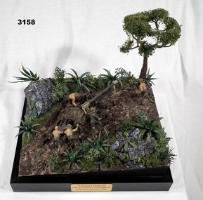 Bendigo Military Museum
Memorabilia - DIORAMA, KOKODA, Post WW2
Diorama inspired by image from State Library of Victoria image No H98 104 / 2102.Diorama mounted on black base. 1/35 scale model of 25 pounder field gun with 5 man crew maneuvering a gun into position around a tree with a pulley system. In black print on gold name plate attached to front of black base:: “25 Pounder Field Gun 14th Australian Field Regiment, Kokoda, September 1942”military history-army, arms-ordnance, handcrafts, kokoda -
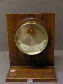
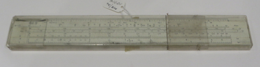 Federation University Historical Collection
Object - Calculator, Faber Castell, Slide Rule
White celluloid and clear sliding 'bridge', black printing. Various units and scales. In a clear celluloid case with elongated end for easy removal and safe storage. Used for engineering calculations. Faber Castell Made in Germany faber castell, slide rule, engineering calculations, germany, german slide rule -
Glenelg Shire Council Cultural Collection
Photograph - Photograph - aerial view of Portland, c. 1954
Black and white aerial photograph of coastline around Portland. Black border, scale all sides, 5 rows of 3 't' at regular intervals. Ocean on left, land on rightFront: '607 - 54 ' - handwritten, white, border 'RUN 7' 'PORTLAND', printed, white, borderaerial photography, central portland, portland harbour, south west coastline -
Glenelg Shire Council Cultural Collection
Photograph - Photograph - aerial view of Portland, c. 1954
Black and white aerial photograph of coastline around Portland. Black border, scale all sides, 5 rows of 3 't' at regular intervals. Ocean at right, land on left.Front: '820 - 7' -- handwritten, white, lower border 'RUN 5' 'PORTLAND', printed, white, lower borderaerial photography, central portland, portland harbour, south west coastline -
Glenelg Shire Council Cultural Collection
Photograph - Photograph - aerial view of Portland, c. 1954
Black and white aerial photograph of coastline around Portland. Black border, scale all sides, 5 rows of 3 't' at regular intervals. 50/50 land and oceanFront: '607 - 51 ' - handwritten, white, border 'RUN 7' 'PORTLAND', printed, white, borderaerial photography, central portland, portland harbour, south west coastline -
Glenelg Shire Council Cultural Collection
Photograph - Photograph - aerial view of Portland, c. 1954
Black and white aerial photograph of coastline around Portland. Black border, scale all sides, 5 rows of 3 't' at regular intervals. 75/25 ocean to landFront: '784-146 ' - handwritten, white, border 'RUN - 7 A PORTLAND', printed, white, borderaerial photography, central portland, portland harbour, south west coastline -
Glenelg Shire Council Cultural Collection
Photograph - Photograph - aerial view of Portland, c. 1954
Black and white aerial photograph of coastline around Portland. Black border, scale all sides, 5 rows of 3 't' at regular intervals. 60/40 land to ocean.Front: '607 - 93 ' - handwritten, white, border 'RUN - 6 PORTLAND', printed, white, borderport of portland archives, aerial photography, portland harbour, south west coastline -
Glenelg Shire Council Cultural Collection
Photograph - Photograph - Aerial photograph of coastline, Portland Victoria, c. 1954
Black and white aerial photograph of coastline around Portland. Black border, scale all sides, 5 rows of 3 't' at regular intervals. 80/20 ocean to landFront: '784 - 147 ' - handwritten, white, border 'RUN 7 A PORTLAND', printed, white, border -
Glenelg Shire Council Cultural Collection
Photograph - Photograph - aerial view of Portland, c. 1954
Black and white aerial photograph of coastline around Portland. Black border, scale all sides, 5 rows of 3 't' at regular intervals. 90/10 ocean to landFront: '784 - 148'- handwritten, white, border 'RUN 7 A PORTLAND', printed, white, borderaerial photography, central portland, portland harbour, south west coastline -
Glenelg Shire Council Cultural Collection
Photograph - Photograph - aerial view of Portland, c. 1954
Black and white aerial photograph of coastline around Portland. Black border, scale all sides, 5 rows of 3 't' at regular intervals. 20% ocean, 80% land.Front: '820 -51' - handwritten, white, border 'RUN 6' 'PORTLAND', printed, white, borderaerial photography, central portland, portland harbour, south west coastline -
Glenelg Shire Council Cultural Collection
Photograph - Photograph - aerial view of Portland, c. 1954
Black and white aerial photograph of coastline around Portland. Black border, scale all sides, 5 rows of 3 't' at regular intervals. Buildings visible bottom leftFront: '607 -106' -- handwritten, white, lower border 'RUN 5' 'PORTLAND', printed, white, lower borderaerial photography, central portland, portland harbour, south west coastline -
 Federation University Historical Collection
Equipment - Object, Voltmeter, c1930
Used in the Ballarat School of Mines Electrical Engineering from around 1930-1936.Round glass fronted brass dial mouned on timber stand. Postive and negative terminals below dial. Simi-circular scale, non-linear graduations: 40-80 voltsvoltmeter, scientific instrument, ballarat school of mnes, arthur senior, nalder brothers