Showing 33947 items
matching building-fittings
-
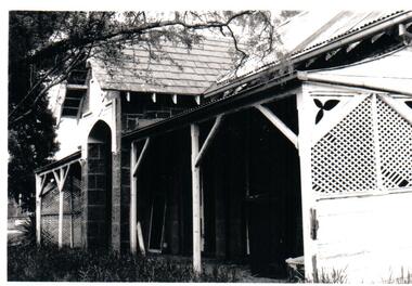
 Stawell Historical Society Inc
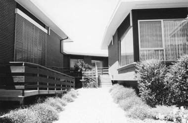
Photograph, Eventide Homes Buildings
Eventide Homes Buildingsstawell -
 University of Melbourne, Burnley Campus Archives
Photograph - Black and white print, Information Branch Victorian Department of Agriculture, Students in the Library, 1967
Library in the Administration BuildingBlack and white photograph. Judy Bertram and Owen Rich in the Library .On reverse, "Photograph by Information branch Victorian Department Of Agriculture Ref. No. D.1100.D."judy bertram, owen rich, library, students, publicity -
 Buninyong & District Historical Society
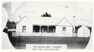
Photograph - Photograph of Original Photograph, "Carriers Arms" hotel, Clarendon
historic, social, buildings, Photo of B/W photograph of "Carriers Arms" hotel, Clarendon, date unknown - built 1855, demolished 1930"The Carriers Arms", Clarendon Built 1855, demolished 1930clarendon, carriers arms, hotel, -
 Buninyong & District Historical Society
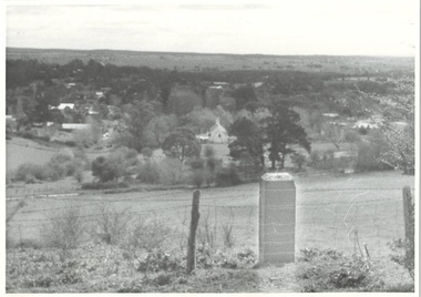
Photograph - Photograph of Buninyong from Mt. Innes, 1993
historic, buildings, landscapeB/W photograph of Buninyong town from Mt Innes, looking west, with George Innes monuments in foreground. Now known as Birdwood Park, earlier named Birdwood Grove in 1917 as part of the Avenue of Honor. The land was donated to Buninyong by George Innes.buninyong, mt. innes, george innes -
 Buninyong & District Historical Society
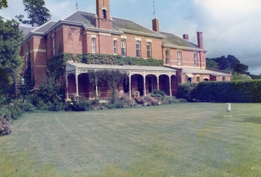
Photograph - Mount Buninyong Homestead, showing front of house and croquet lawn, Mount Buninyong Homestead, 1991
Historic buildings, ScotsburnTaken on a visit to Mount Buninyong Homestead in 1991.houses, landscaping -
 Hume City Civic Collection
Photograph
The Bulla Presbyterian Church and Manse were designed by Thomas Taylor. The buildings are of historical significance because they are examples of some of the earliest buildings erected outside Melbourne and still in use.A black and white photograph of the front view of the Manse at the former Bulla Presbyterian Church, now the Uniting Church. The Photograph shows detail of the end wooden trellis walls and wooden poles supporting the verandah.presbyterian church, uniting church, manses, taylor, thomas, george evans collection -
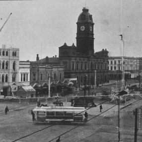 City of Ballarat Libraries
Photograph - Card Box Photographs, View south west along Sturt Street, Ballarat circa 1905. From Star 1855-1905 Jubilee publication
Photo was taken from the Ballarat Post Office tower. The National Mutual Building is under construction. Sign on building reads 'H.M. Theatre Farewell Concert Jessie Maclachlan'.sturt street, ballarat post office, national mutual building, h.m. theatre, streetscape, garden, trams, vehicle, commerical, public -
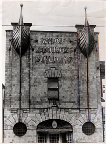 Robin Boyd Foundation
Photograph
The Wharf Labourers building (1915-16), by architect Robert Joseph Haddon was at 480 Flinders Lane. The copper features on the were given to Robin Boyd when the building was demolished.Black and white photographwharf labourers building, robin boyd -
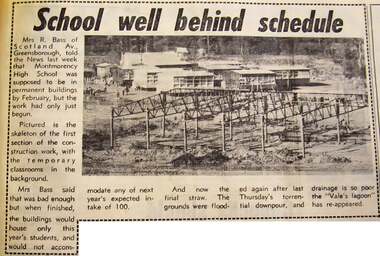 Greensborough Historical Society
Newspaper - Newspaper Clipping - Digital Image, Diamond Valley News, School well behind schedule, and, Lake forms in school ground, 1970
Two articles on the building of Montmorency High School (Mo8068). "School well behind schedule" (20/01/1970) describes the delay in completing the building and shows temporary classrooms behind the frame of the new building. "Lake forms in school ground" (24/03/1970) shows storm water laying on the ground at the school site.Digital copy of newspaper articlemontmorency secondary college, montmorency high school -
 Flagstaff Hill Maritime Museum and Village
Document - Framed Poster, Borough of Warrnambool, Victoria, Australia, after 30/06/1875
This document, also referred to as a word picture or Tablet, is framed in glass and timber with gilt trim, is handwritten with colour highlights. The penned letters rest on ruled guide lines, decorated where the lines intersect. The writing gives a description of the state of Borough of Warrnambool around 1875; its location, the area it covers, its population, Harbour and facilities, public buildings and institutions, imports and exports, financial worth, number of houses, connection with other areas of the Colony. A possible reason and origin for the document is found in an article ‘Link with US Exhibition’ from the Warrnambool Standard of December 19, 1981, written by local historian Bruce Morris. The writer mentions that the Warrnambool Borough Council met on 15th June 1875 and recorded a letter from G.C. Levey , secretary to the Melbourne group of commissioners representing the Colony, and Victoria in particular, for the Philadelphia Centennial Exhibition of 1876. The letter asks Council to provide “statistics as to the population, social condition and commercial and industrial state of the district in and around Warrnambool.” A sub committee was formed for the project. The Mayor, Cr. Thomas King, wrote and signed a Report, presented to the council on July 14, 1875, in which “The Committee … begs to recommend that a Tablet be prepared setting for the particulars respecting the following matters relating to the Borough”. The matters included area, population, annual income, churches, schools, other public buildings, societies and companies, general description of houses erected, and returns of exports and imports for 1874. The minutes note that the Report was adopted. The article above also notes the opinion of Warrnambool printers who have examined the document; it is almost certainly to be an old lithograph, which means there could be several copies. It is possible that there may be a copy in Melbourne and another in Philadelphia. It is interesting to note that (1) the quoted location co-ordinates are for an “Unnamed Road, Packsaddle NSW 2880, Australia”, and that the DMS co-ordinates for Warrnambool’s Council Offices differ, being 38.23.9.12 South, 142.28.52.887. (2) the date for “Exports and Imports for the Year Ending 30th June 1875” is different to the period mentioned by Cr. King in the sub committee’s Report of recommendation “returns of exports and imports for 1874”. The information required to have the figures for the end of June 1875 would need to have been compiled very quickly for the Tablet to be ready for the opening of the Philadelphia Exhibition on 10 May 1876. The document/certificate shows the following – - - - - - - - - - - - - - - -- - - - - - - - - - - - - - -- - - - - - - - - - - - - - -- - - - - - - - - - - - - - - “Victoria Australia, Borough of Warrnambool. Latitude, 30.24.50 South, Longitude 142.32 East The Principal Port in the Western District of the Colony and the Centre of its Choicest Agricultural Lands. Established a Municipality in 1855, and Created a Borough 1863. Population in 1875 4,500. Warrnambool is the nearest Port to Melbourne on the Western Seaboard, being about 160 miles distant. Coaches run to and from the Metropolis daily, in connexion [connection] with the Railway of Geelong and Steamers belonging to Local Companies sail between Melbourne, Warrnambool, Belfast [renamed Port Fairy], and Portland several times weekly. The Harbour is known as Lady Bay, and is partially protected by a reef of rocks stretching from the mouth of the Hopkins River. The formation of a Breakwater has been decided upon by the Government, to extend 600 yards, at an estimated cost of £100,000. There are two substantial Jetties, one of 800 and the other of 600 feet in length. The former is connected with the Town by means of a Tramroad, along which Goods, inwards & outwards, are conveyed, & the latter has been constructed solely for the purpose of facilitating the transit of material for the formation of the Breakwater. In addition to the trade of the Borough and District, the principal Townships up country receive their supplies from Melbourne and ship their exports through Warrnambool. Potatoes form the staple produce of the district, and the richness of the soil can be estimated by the fact that the Government Statistics for 1875 give as the average yield a return of Seven Tons to the acre. Several thousand acres between Warrnambool and Tower Hill are now being laid down in Potatoes by Tenants who have leased the lands at rates up to £5 per acre for the season 1875-6. Wool, Tallow, hides &c are also largely exported, while the shipments of all descriptions of Farm Produce are annually increasing. Area of Borough, 3362 Acres. Net Annual Value £27,000. Annual Revenue £5,500. Number of Houses in Borough 800. Public Buildings and Institutions Churches. Church of England, Roman Catholic, Presbyterian, Wesleyan, Congregational and Baptist. Schools. Three State Schools, average attendance nearly 1000. New Building in course of erection. Several private establishments. Banks. Bank of Australasia, Bank of Victoria, National Bank, Colonial Bank and Savings Bank. Public Buildings. Court house, Custom house, Post & Telegraph Offices, Survey & Land Offices, Shire £, Town Hall, Mechanics Institute, Volunteer Orderly Room, Odd Fellows Hall, Hospital & Benevolent Asylum, Temperance Hall &c. Companies & Societies. Steam Navigation Co, Woolen Mill Co, Gas Co, Racing Club, Amateur Turf Club, Agricultural Society, Farmers’ Club, Cricket Club, Anglers’ Society, Building Society, Freemasons Odd Fellows, Foresters, Druids, Hibernians. Protestant Alliance, Rechabites, Sons of Temperance, &c, Fire Brigade &c. --- Exports and Imports for the Year Ending 30th June 1875 –-- --Exports Total Tonnage 27,800 (Calculated at the Current Warrnambool Market Prices) Potatoes Wool Wheat Barley Hides Skins Fowls Butter Cheese Eggs Tallow Leather Ale Pigs Sheep Sundries --Imports 13,000 Tons Of the Estimated Value of £520,000 Total Tonnage of Exports and Imports 40m900 Tons, Value £806,627 Passenger Travels, to ad from Warrnambool during year, 10,000 persons Revenue from all sources paid through Warrnambool Sub Treasury From 1860 to June 1875 £1, 292, 300 Thomas King [signed] Mayor Henry T Read [signed] Town Clerk” - - - - - - - - - - - - - - -- - - - - - - - - - - - - - -- - - - - - - - - - - - - - -- - - - - - - - - - - - - - - The document is of historical, social, economic and local significance in that it summarises activities, business, community, trade, travel and government at a point in time in Warrnambool’s history – 30th June 1875.Document, also referred to as a ‘word picture’ or ‘tablet’. Document is framed in glass and timber with gilt trim, handwritten with colour highlights. The penned letters rest on ruled guide lines, decorated where the lines intersect. Document outlines the establishment of Warrnambool as a Municipality in 1855 and Borough in 1863, with a population of 4,500 in 1875. It states geographic location, public buildings and institutions, harbor facilities and imports and exports for the year ending 30th June 1875. Two signatures "Thomas King" Mayor and "Henry T Read" Town Clerk. It shows the Coat of Arms of the Borough of Warrnambool.Signatures - "Thomas King" Mayor and "Henry T Read" Town Clerk. Warrnambool Coat of Arms; “British Coat of Arms, above sailing vessel and sheaf of wheat in sun, motto “By these we flourish” and around circumference “Borough of Warrnambool 1855”flagstaff hill, warrnambool, shipwrecked coast, flagstaff hill maritime museum, maritime museum, shipwreck coast, flagstaff hill maritime village, great ocean road, borough of warrnambool, municipality of warrnambool, document borough of warrnambool 1875, word picture of warrnambool 1875, tablet of borough of warrnambool 1875, statistics borough of warrnambool 1875, lithograph borough of warrnambool 1875, coat of arms warrnambool, warrnambool city motto – in these we flourish, establishment of warrnambool, warrnambool history, thomas king mayor of warrnambool, henry t read town clerk of warrnambool, warrnambool breakwater, warrnambool jetty, warrnambool imports and exports 1875, warrnambool agriculture 1875, warrnambool business 1875, warrnambool population 1875, centennial exhibition philadelphia 1876, framed certificate -
 Surrey Hills Historical Society Collection
Photograph, Bonfire, Beckett Park, Balwyn (Surrey Hills), c1937/8, 1937
"The bonfire at Beckett Park was the culmination of the EMPIRE DAY/CELEBRATIONS in Surrey Hills in 1935 and 1936. In 1937 vandals lit the fire prematurely but residents hastily rebuilt it - about / 100 tons including old tyres. A volunteer fire-watcher had his caravan close by until lights-up time on Saturday night. / Courtesy Ian Barkla. / see 180 (handwritten on backing board)." / "BONFIRE BUILDING at BECKETT PARK/EMPIRE DAY CELEBRATIONS IN 1930s/ The celebrations were centred on the/ shopping centres in Surrey Hills and/Mont Albert to boost local business (and/ the spirits of residents) after the Depression./ - from a glass negative - Mr Ian Barkla."Image depicting the building of a large bonfire made primarily from rubber tyres, supported by a wooden frame c1937/8. There is a significant crowd of people watching the erection of the pyre from ground level. Several members of the crowd are seated or holding bicycles. There are multiple persons situated on the pyre or on a ladder propped up against the mound of tyres. The area containing the pyre has been fenced off with rope (?). A white coloured caravan in situated to the right (facing) of the bonfire in close proximity to a dark coloured car. Two stone towers and a park bench are also visible in the image.Black and white, W 25.3 cm x H 20.3 cm, landscapeparks and reserves, beckett park, balwyn, bicycles, crowds, empire day, depression 1929-1939, economic depression, frank leslie barkla, bonfires -
 Orbost & District Historical Society
black and white photograph, Howard D. Bulmer, 1907
This photograph shows the Orbost Shire Council in 1907. In the back row are : A. Hillyard; John Draffin (sec.); David Jonson; Archie Rodwell; Hugh Cameron; Geotge Nixon; J. Hassett; Percy Watt; Wm Anderson (engineer); Wm Ross (S.R. Mail) Seated in front on chairs are : Sam Lynn; R. Pearse; John Johnston; Henry Luke (pres.); Donald Munro; Bill Cumming; Charles Grove The shire covered an area of 9,347 square kilometres and existed from 1892 until 1994 when it became part of the East Gippsland Shire Council. Orbost was at first included in the Bairnsdale Shire from 1882 and was later part of the Tambo Shire. Because of travelling distances the Croajingalong Shire was created in 1892 (name changed to Orbost Shire 17.2.1893 with James Cameron as the first Shire President. In 1994 it amalgamated to become part of East Gippsland Shire Council.This item is associated with the Orbost Shire Council. The shire covered an area of 9,347 square kilometres and existed from 1892 until 1994 when it became part of the East Gippsland Shire Council. A large black / white photograph of a group of men in two rows - front row seated; back row standing. The photograph has been taken outdoors with trees in the background and to the right a wooden building and tank. There is a copy.on front - "Orbost Shire Council - 1907" on back - "March, 1907, Shire Council"orbost-shire-council-1907 local-government -
 Ringwood and District Historical Society
Flyer, Executor's Auction Subdivision Advertisement, Lilydale Road and Oban Road, Ringwood East, Vic. - 1937
Single page advertisement for Executor's Auction of land in Ringwood East on Saturday, May 29, 1937 with locality map showing 26 building sites for auction highlighted in brown, and brief summary of local services available. Subdivision includes Old Lilydale Road, Joseph Street, Dynes Street, Albert Street (later Wyrunga Street), Carcoola Road, and Mount Dandeong Road. (Carcoola Road incorrectly shown as Oban Road on the subdivision plan). Auctioneer - C.E. Carter, (Phone Ringwood 24. -
 Bendigo Military Museum
Photograph - PHOTOGRAPH FRAMED - WW1, Wayne Eels, C.2008/2009
The Grinton Collection. Promenade along the Mediterranean coast of Nice France. Refer Cat No. 1280 for Jack Grintons service details. Photograph framed. Photograph - black and white photograph on paper. Depicting - a promenade space filled with civilians seated and standing with a background of tree and buildings. Frame - timber, light varnish finish, Perspex front, cardboard backing."Group 3: Trip of a Lifetime". "D. Promenade des Anglais".framed accessories, camera on the somme, 38th bn, grinton, ww1, nice -
 Kiewa Valley Historical Society
Papers - Hollonds' Family and their memories, 2013
The Hollonds' family were original settlers in the Kiewa Valley at Mulagong. Their descendants owned land in Tawonga, Tawonga South and between the East and West of the Kiewa river. Hollonds had a cattle run on Mt Fainter which was later given to the Hicks family.Members of the Hollonds family lived, worked and married in the Kiewa Valley. These papers describe the connection to the families and the Kiewa Valley.Typed papers donated by the Hollonds' family covering: The Hollonds Family History, Cattlemen, 'Snowy' Miller, Mrs Hollonds' Boarding house, SEC Depot at Tawonga, building of Bogong Township, Early Scenes on the Kiewa Scheme.hollonds family, tawonga station, cattlemen, mt beauty land, tawonga boarding house -
 Federation University Historical Collection
Book, A Descriptive Catalogue of the Minerals in the Museum of the School of Mines, Ballaarat, 1882, 1882
The Museum of the Ballarat School of Mines was established in 1872. The curator in 1882 was Ferdinand M. Krause. Prefatory Notice by James Oddie). The want of a guide through the technical collections of The School Mines has long been felt by visitors and students - a guide , not so much to those who merely 'look' at the various exhibits in the Museum, but an instructor to those who desire to take away with them some practical information on the natural occurrence and economical value of the objects exhibited. This want is being filled by the labour of Mr. Krause, whose first installment - 'A Descriptive Catalogue of the Minerals' - is herewith represented to the visiting public." Introduction to the catalogue: " The collection is still in its early growth, and far from being a complete representation of the Mineral Kingdom; many varieties, species, and even whole groups are absent. This state of incompleteness will, no doubt, be adjusted in the sequence, and progressive lists issued from time to time. 'Ad interin' the present catalogue will, be found useful to students and visitors of the School. As far as practicable, the classifications of the minerals accords with that adopted at the Royal School of Mines, London. The numbers prefixed to the species in the catalogue agree with those on the descriptive labels which accompany each specimen, and also with those attached to the specimens themselves. On the descriptive labels the chemical composition of the minerals is expressed in formulae usually employed in standard mineralogical works. Students who have note paid attention to mineralogical chemistry will note that each dot over a symbol is equivalent to one atom of oxygen, .... A bar through a symbol denotes a double atom of the base, .... " In 1882 the collection was housed in 33 cases. The catalogue outlines the specimen types housed in each case. The classification of minerals accords with that adopted at the Royal School of Mines, London. Leather covered book of 94 pages with gold lettering on the front, including "F.M. Krause". The book includes a plan of the museum layout, plan of the grounds and buildings of the Ballarat School of Mines and a prefatory notice by James Oddie.ballarat school of mines, ballarat school of mines museum, museum, krause, ferdinand krause, fm krause, oddie, james oddie, geology, mineralogy, charles boyd, f.m. krause, minerals, curator -
Federation University Historical Collection
Photograph, Mount Helen Campus Buildings, c2003
.1) Former Art building at Mt Helen. In 2005 it was used by IBM. .2) Roundabout in Chancellor Drive, looking towards the Geoffrey Blainey Auditorium. .3) Peter Blizzard sculpture in front of the Geoffrey Blainey Auditorium. art building, a building, mount helen campus, ibm, geoffrey blainey auditorium -
 Bendigo Military Museum
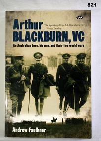
Book, Andrew Faulkner, Arthur Blackburn, VC, c.2008
An Australian Hero, his men and their two world wars. Soft cover book in brown and sepia colours, 498 pages. Front cover has photo of 4 soldiers walking towards the camera with building in the background. Written on first page: Donated by Len Buches Family.books, military, biography -
 Phillip Island and District Historical Society Inc.
Newspaper clippings, 04/01/1965
Collection of newspaper clippings in scrap book dated 1960 - 1973. Taken probably from Sentinel Times of Wonthaggi.Newspaper article with photo of Albert Robertson and model shell house. Text explains his building up of a tourist attraction by cementing shells onto 18" fibro plaster sheets to make pictures of people and objects."Albert's House is more than a shell"local history, newspapers, shell house on summerland peninsula, phillip island, jean jamieson -
Glenelg Shire Council Cultural Collection
Postcard - Postcard - Bluestone Building, n.d
Black and white photo postcard. Two storey bluestone building with iron verandah, wrought iron lacework. Two men in leather aprons, leaning on verandah posts. Sign on verandah roof: 'W.V. VIVIAN SADDLER' -
Glenelg Shire Council Cultural Collection
Postcard - Postcard - Fancy dress ball, Portland Victoria, c. 1924
Black and white photo postcard. Fancy dress ball held at North Portland, 18th July, 1924. About 40 adults and children, all in fancy dress, sitting/standing in a group, outside a wooden buildingFront: 'FANCY DRESS BALL. NORTH PORTLAND. 18.7.24' -white script, bottom edge -
Glenelg Shire Council Cultural Collection
Photograph - Photograph - Sailors, n.d
Black and white photo mounted on heavy card. Image shows a large group of sailors in uniform posed in front of wooden building. Officer standing on left. Dress estimated to be late 19th, earl 20th Century. -
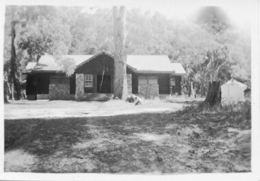 Halls Gap & Grampians Historical Society
Photograph - B/W, C 1946
A photo of the Comfort Station in the Halls Gap Picnic and Camping Reserve.The photo shows a wood and stone building at the rear of a clearing with a large eucalyptus tree growing close to the front of it. In the background is heavy bush. A tent or large cloth can be seen on the right beside a large tree stump.buildings, mountain grand -
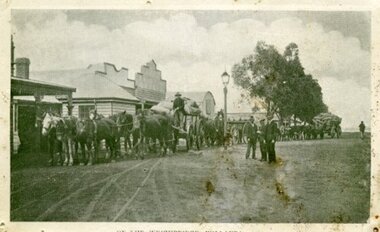 Ararat & District Historical Society (operating the Langi Morgala Museum)
Photograph, Willaura Weighbridge
This photograph shows a point in time (late 19C) at the Willaura weighbridge which no longer exists. The weighbridge was part of a transportation system that included horses, wagons, silos, and trains and when this photograph was taken, the weighbridge was crowded with people and wagons. Black and white photograph of a streetscape with wide dirt roads, some early European buildings and three supply wagons. Two are horse drawn and the third is pulled by bullock, with six men driving the wagons and standing in the roadway. Front: "Willaura Weighbridge"willaura, weighbridge, postcard, horses, wagons, wool, transport -
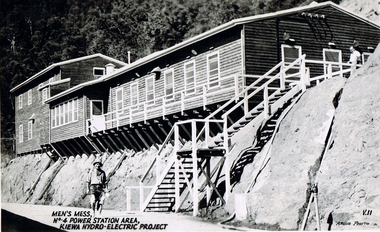 Kiewa Valley Historical Society
Postcard Circa 1950, Men's Mess No.4 Power Station, Kiewa Hydro-Electric Project
This postcard was produced in the 1950's for the tourist trade in the Kiewa Valley and Alpine region. It encompasses the period when the State of Victoria was pressured by the ever increasing demand by industry and its population for electricity supplies. Hydro electricity was seen as an untapped natural resource to quench this demand. The Victorian Alps and the rivers flowing into its valleys was ideal for the construction of the Kiewa Hydro Electricity Scheme. The late 1940's saw the development of this scheme and the changing of sections of alpine landscape is covered by this and other postcards/pictures (tourists, construction workers, and established rural populations). This period in time was before the established wildlife and forest/nature groups became political activist who changed legislative acts to protect the environment.Although this photo details the eating facilities of the construction workers at the power station it was not only a postcard for the people employed in the Hydro Scheme is was also provided to tourists visiting the area and thus used for promotional purposes.This rural region (Kiewa Valley/alpine plains) was at most only significant to a smaller group of winter sports, summer hikers/horse riders and rural farmers/graziers. The numbers of tourists and the increase in the local resident population was boosted by the construction of the Hydro Electricity Scheme. This influx to the regional population resulted in a corresponding diversity in services and brought about an environment that responded to a growing level of tourists and thereby permitting this industry to grow more rapidly than it would have naturally. This postcard details an attraction to the "cleaner" method of providing electricity. This postcard was purchased in 1950 by a surveyor at Landford's Gap. The men shown in this photograph would have been employed by the S.E.C. under the Kiewa Hydro-Electricity Scheme.This item is a scanned black and white photograph of a construction worker walking from stairs leading down from the men's mess building, in 1950. See 0480 (A) -(C), (E) - (F) for other photos of similar postcards"MEN'S MESS No.4 POWER STATION AREA, KIEWA HYDRO-ELECTRIC PROJECT" "ARGUS PHOTO V.IIkiewa valley tourism, victorian alps, alternate energy supplies, alpine population growth, secv -
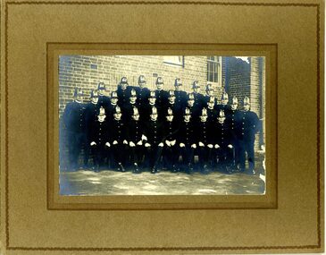 Victoria Police Museum
Photograph (Victoria Police Group Photo), Police Officers in group photo, 1920s
Black and white photograph mounted on brown frame. 26 Police Officers in 1920s uniform pose in uniforms with helmets. Set in a terrace with an open brick building with windows on the background. Amongst them is William Arthur Poulter.Handwritten: BILL POULTER 1925 // CENTRE ROW // 5TH FROM LEFT Stamp: PHOTOGRAPH TAKEN // AT YOUR OWN HOME // P. J. DWYER // Onr. Harding & Salisbury Sts. // COBURG // PHOTOGRAPHS COPIED // AND ENLARGEDpoulter, william, william arthur poulter, victoria police museum, dwyer, p. j., police officers -
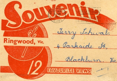 Ringwood and District Historical Society
Souvenir - Folder, Samuel Lee and Co, 12 Black and White Souvenir photos of Ringwood, 1975, 1957
Souvenir photos sent to Terry Schwab in 1957 from Mick who hoped he would have many memories of Ringwood. Donated to the Society by Terry.Buff coloured folder with red printing containing 12 black and white favourite photos of Ringwood. Streetscapes, buildings and Ringwood lake. 4 separated from rest. From Mick. +Additional Keywords: Schwab,Terry -
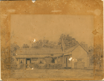 Orbost & District Historical Society
drawing, early 20th century before 1923
The original licence for the Sans Souci Hotel was granted to A. G. Ventry in 1909. The hotel burned down on 15.06.1923 and was rebuilt. It burned down again in 1936 and the licence surrendered 21.12.1936. with the owner compensated with 475 pounds and the occupier 50 pounds. (info Victoria Government Gazette Thursday December 24 1936) The hotel was at Upper Bemm River near Club Terrace in East Gippsland.This item is a contemporary pictorial record of a building which was once a popular destination for adventurous tourists in the early 1900's. There are few photographs of this hotel.A pencil (?) drawing of the old Sans Souci Hotel at Upper Bemm River, near Club Terrace. It is a one storey timber building. The drawing has been framed at one time causing differences in light damage.sans-souci-hotel bemm-river -
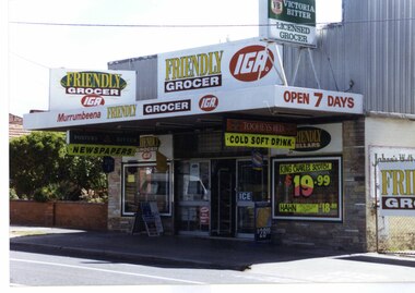 Glen Eira Historical Society
Photograph, Murrumbeena Road, 235, Murrumbeena, 2001
Originally labelled "Beauville Estate, Established 1936, Still Thriving 65 years on, 10th March 2001", the Beauville Estate Album contains colour photographs of houses in the Estate. They were taken around the time of the Beauville Estate’s 65th Heritage Celebration held on 10/03/2001 and donated to the Caulfield Historical Society shortly afterwards. Photographer unknown. No. 235 is NOT covered by the Heritage Overlay HO12.Colour photograph of a supermarket. The property features a flat roof awning, corrugated parapet, irregular multi-coloured slate tile and brick facade and extensive advertising over the front and side of the building plus on the gate to the right.Murumbeena FRIENDLY GROCER IGA / OPEN 7 DAYS / NEWSPAPERS / COLD SOFT DRINKmurrumbeena, architectural styles, 1930's, inter war style, a.v. jennings, av jennings, jennings, beauville estate, murrumbeena road, commercial establishments, shops, supermarkets, sir albert victor jennings, a v jennings construction co, beauville estate heritage area, glen eira city council, architectural features, jennings group limited, land subdivision, beauville historic area, brick shops, parapets, advertising signs, murumbeena friendly grocer iga -
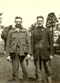 Federation University Historical Collection
Photograph - Black and White, Brit Archibald, Frank Wright and Roy Archibald, 1922, 23/11/1922
Frank Wright was a renown resident of Smeaton, where he was born. He lived at Laura Villa, and attended Smeaton State School. His father William was a gold miner and his mother's name was Sarah. Their family won many singing and instrumental awards. Frank was tutored by Percy Code and was awarded a gold medal for the highest marks in the ALCM examinations in the British Colonies at the age of seventeen years. He became the Australian Open Cornet Champion by the age of eighteen. A year later, Frank conducted the City of Ballarat Band, and later the Ballarat Soldiers’ Memorial Band. He formed the Frank Wright Frisco Band and Frank Wright and his Coliseum Orchestra. These bands won many South Street awards, and Frank as conductor won many awards in the Australian Band Championship contest. In 1933 Frank Wright sailed to England to conduct the famous St Hilda’s Band and was later appointed Musical Director of the London County Council, where he organized many amazing concerts in parks, in and around the London district. He was made Professor of Brass and Military Band Scoring and conducted at the Guildhall of Music and Drama. Frank was often invited to adjudicate Brass Band Championships around Europe, in Australia, including South Street and in New Zealand. The Frank Wright Medal at the Royal South Street competition is awarded to an individual recognized as making an outstanding contribution to brass music in Australia.Black and white photograph of two men standing on a grassed area at Newlyn, with trees in the background and the edge of a building on the left side. They are both dressed in long pants, jackets and scarves. The men are Roy Archibald and Frank WrightWritten in pen on back - Roy Archibald 21, Frank Wright 21, Taken, while on a couple of days visit to Newlyn, by Brit Archibald, 23/11/22frank wright, cornet, conductor, ballarat, roy archibald, brit archibald, newlyn