Showing 486 items
matching kilometres
-
 Warrnambool and District Historical Society Inc.
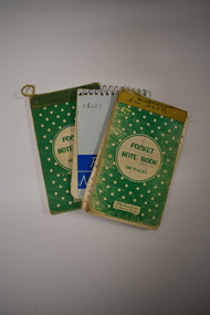
Notebooks, Flexibound Books, 1970s
These notebooks were used by Charles and Vida Williams when they were Post Master and Post Mistress at the Nullawarre Post Office in the mid 20th century. Nullawarre is a small settlement 25 kilometres south east of Warrnambool and is a largely agricultural area. European settlement began in the area in the late 1860s. These notebooks are of minor interest as ones used by Charles and Vida Williams when they ran the Nullawarre Post Office in the mid 20th century. .1 This is a small notebook with a green cover bound with yellow tape. The pages are loose. They have handwritten material concerning car travel. Originally there were 100 pages but there are now fewer than this. .2 This is a small notebook similar to the one above except that it is bound with green tape and the pages are intact. It contains handwritten information on food expenses. .3 This is a small notebook with a blue cover and metal spiral binding. It contains handwritten material of a personal nature – addresses etc. Most of the pages are blank. ‘Pocket Notebook’nullawarre post office, charles & vida williams, nullawarre, history of warrnambool -
 Warrnambool and District Historical Society Inc.
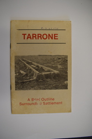
Booklet, Tarrone, 1983
A brief outline of the history of the Tarrone estateThis is a booklet of 20 pages. It has a buff-coloured cover with two black and white photographs and red print. The pages contain black and white photographs, printed text, maps and illustrations. The booklet is stapled non-fictionA brief outline of the history of the Tarrone estatesoldier settlements post world war two, tarrone estate -
 Warrnambool and District Historical Society Inc.
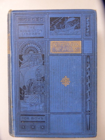
Book, In The Wilds of Africa, 1901
This is a boy’s adventure book owned by Francis Skuse of Strathallan, Allansford in 1906. Francis Skuse, the son of John and Catherine Skuse, was a grazier at the property Strathallan, six kilometres from Allansford. His property included the Strathallan mine which had limestone/carbonates deposits. He died in 1962. This book is of interest because it was owned by Francis Skuse, a farmer and long-time resident of Strathallan, near Allansford.This is a hard cover book of 558 pages. It has a blue cover with the names of the title and author in blue print on a gold background. The front cover and the spine are patterned with scrolls and imprints of sailing ships. The book contains several black and white sketches. The inscription on the first page, with the page partly detached, is handwritten in blue ink. ‘Francis Skuse, Strathallan, Allansford, June 3rd 1906’. francis skuse, strathallan -
 Orbost & District Historical Society
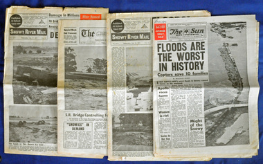
newspapers, February 1971
The 1971 floods at Orbost were the worst on record. At Jarrahmond the river rose to a height of 11 metres and on the flats spread to one and a half kilometres wide. Considerable damage was done to railway infrastructure, roads and farms. More information from the APRIL, 2008 newsletter by John Phillips. (see orbosthistory.com.au)These newspapers are contemporary records of a significant local event.Four newspapers and a set of clippings from various papers. They contain information and photographs pertaining to the 1971 floods in Orbost. 2557.1 is a Sun News Pictorial dated 8.2.1971. 2557.2 is a Snowy River Mail dated 10.2.1971. 2557.3 is an east Gippsland News dated 12.2.1971. 2557.4 is a Snowy River mail dated 12.2.1971 and 2557.5 is a collection of various clippings.floods-orbost-1971 newspaper snowy-river-mail sun-news-pictorial -
 Greensborough Historical Society
Photograph - Digital Image, Willis Vale site, 2014_
Photograph of the site of the 'Willis Vale' homestead, home of the Partington family. The derelict Willis Vale house was destroyed in 1964 when a fire originating from North Plenty Gorge - Kurrak Road - was lit by two teenage boys and made its way several kilometres down to Partington's Flat Greensborough.Digital copy of colour photograph."This house is where Willis Vale homestead was on Partingtons Flat"partington family, willis vale -
 Moorabbin Air Museum
Photograph (item) - Southern Cross Fokker Tri Motor flown by Sir Charles Kingsford Smith
The Southern Cross is a Fokker F.VIIb/3m trimotor monoplane that was flown by Australian aviator Charles Kingsford Smith, Charles Ulm, Harry Lyon and James Warner in the first-ever trans-Pacific flight to Australia from the mainland United States, a distance of about 11,670 kilometres (7,250 mi), in 1928. -
 Orbost & District Historical Society
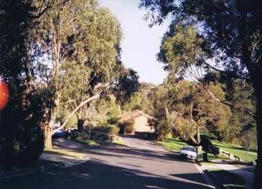
Invitation, 1969
The current building was opened on Friday 28th February 1969 by the Premier of Victoria, The Hon. Sir Henry E. Bolte, K.C.M.G., M.P. The Shire of Orbost was a local government area about 380 kilometres east of Melbourne, the state capital of Victoria, Australia. The shire covered an area of 9,347 square kilometres and existed from 1892 until 1994. Originally, Orbost was part of the Bairnsdale Road District which was created on 30 April 1867. Splitting away as part of the Shire of Tambo in 1882, Orbost was first incorporated as a shire in its own right as the Shire of Croajingolong on 30 May 1892. It received its present name on 17 February 1893. On 3 January 1913 part of its western riding was annexed to Tambo as its Cunninghame Riding. Local governments play an important role in the lives of citizens in Australia. Local government authorities exist to provide services and amenities to local communities, and are also responsible for regulating and providing services for land and property in their district. This item is representative of a time when Orbost had its own Shire Council. A stapled program and invitation to the official opening of the new Orbost Shire Council Municipal Offices. A light blue card with the Orbost Shire Council insignia and gold print on front. The invitation is addressed to the secretary of Orbost Historical Society Judith Walcott.handwritten in blue pen - "Judith G Walcott"orbost-shire-council -
 Warrnambool and District Historical Society Inc.
Document, Receipt March 11 1899, 1898
Grassmere is a small hamlet about 12 kilometres from Warrnambool. It is a farming area. The Grassmere Gold Mining Company, presumably established by local people in Grassmere, was created in 1898 for the purpose of acquiring from Messrs James and Mewha a lease of a Cassilis gold mine (23 acres). £5000 was to be raised in shares of five shillings and one shilling each. The Manager of the Company was Horatio Dickson of Melbourne and the brokers were McMeekin and Co. of Melbourne and Warrnambool and Dickson and Osborne of Melbourne. This reef mine was one of several in Cassilis, Gippsland, 12 kilometres north west of Swifts Creek. The gold-bearing quartz reefs were discovered in 1885 and worked to 1914. It is not known whether the Grassmere Cassilis mine was a financial success but the mining operations were impeded by the hardness of the stone in the area. William Robinson was a farmer in the Grasmere district. This receipt is of considerable interest as one of only three items the Warrnambool and District Historical Society has that is connected to the Grassmere Gold Mining Company. The gold mine establishment was one of the minor events in the district in the 1890s. This is a buff-coloured 1899 receipt for William Robinson who has paid six shillings and threepence for part payment of his shares in the Grassmere Gold Mining Company. The receipt has black printing and black-ink handwriting. There is one stamp of the Manager ‘H.S. Dickson’ and another of ‘Grassmere Gold Mining Company No Liability’. The receipt has several holes caused by silver fish damage. ‘March 11th 1899, Received from Mr Wm. Robinson the sum of six shillings and threepence being the amount of 3rd call of 1½ per share due on 50 shares nos. 12651/12700 in the above Company, H.S.Dickson, Manager’ grassmere, grassmere gold mining company, william robinson -
 Orbost & District Historical Society
envelope and receipt, Snowy River Mail as "Mail" Print, May 17 1956
This receipt was issued to R. C. Morgan of Orbost. on May 17, 1956. It was for rent of reserve for six shillings. It was issued by the Orbost Shire Council. The Shire of Orbost was a local government area about 380 kilometres east of Melbourne, the state capital of Victoria, Australia. The shire covered an area of 9,347 square kilometres and existed from 1892 until 1994. Originally, Orbost was part of the Bairnsdale Road District which was created on 30 April 1867. Splitting away as part of the Shire of Tambo in 1882, Orbost was first incorporated as a shire in its own right as the Shire of Croajingolong on 30 May 1892. It received its present name on 17 February 1893. On 3 January 1913 part of its western riding was annexed to Tambo as its Cunninghame Riding. Local governments play an important role in the lives of citizens in Australia. Local government authorities exist to provide services and amenities to local communities, and are also responsible for regulating and providing services for land and property in their district. This item is representative of a time when Orbost had its own Shire Council. A widow - faced envelope with a green threepence stamp top right corner. At the top is "Shire of Orbost". Bottom right is "If not claimed within 7 Days please return to SHIRE HALL, ORBOST".There is a receipt to R.C. Morgan for 6/- being for the "rent of reserve" and signed by L.A. Walker. It has the Orbost Shire logo in the top left corner.orbost-shire-council morgan-r.c. -
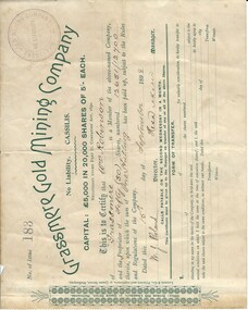 Warrnambool and District Historical Society Inc.
Document, Share Certificate
Grassmere is a small hamlet about 12 kilometres from Warrnambool. It is a farming area. The Grassmere Gold Mining Company, presumably established by local people in Grassmere, was created in 1898 for the purpose of acquiring from Messrs James and Mewha a lease of a Cassilis gold mine (23 acres). £5000 was to be raised in shares of five shillings and one shilling each. The Manager of the Company was Horatio Dickson of Melbourne and the brokers were McMeekin and Co. of Melbourne and Warrnambool and Dickson and Osborne of Melbourne. This reef mine was one of several in Cassilis, Gippsland, 12 kilometres north west of Swifts Creek. The gold-bearing quartz reefs were discovered in 1885 and worked to 1914. It is not known whether the Grassmere Cassilis mine was a financial success but the mining operations were impeded by the hardness of the stone in the area. William Robinson was a farmer in the Grassmere district. This certificate is of considerable interest as one of only three items the Warrnambool and District Historical Society has that is connected with the establishment of the Grassmere Gold Mining Company. The gold mine establishment was one of the many minor events in the district in the 1890s. This is a small buff-coloured certificate detailing the shares of William Robinson in the Grassmere Gold Mining Company (1898). The certificate has green printing and black-ink handwriting. The bottom section (Form of Transfer) is not filled in. There is a stamp of the Grassmere Gold Mining Company with the words ‘No Liability’. There is a decorative pattern in green on the left margin with the address of the company and the name of the printer. ‘This is to certify that Wm. Robinson of Grassmere is a member of the above-named company and the proprietor of fifty (50) shares, numbering 12651/12700 therein, upon which the sum of one shilling has been paid up, subject to the Rules and Regulations of the Company. Dated this 15th day of September, 1898. W.J. Roland, Director, .H. (es) Dickson, Manager.’grassmere, grassmere gold mining company, william robinson, warrnambool -
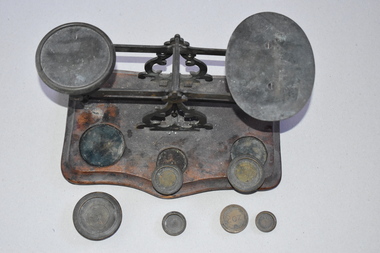 Warrnambool and District Historical Society Inc.
Scales, Nullawarre PO tray & 6 weights, Early 20th century
These scales come from the Nullawarre Post Office. Nullawarre is a small settlement 25 kilometres south east of Warrnambool. The area was settled in the late 1860s and 1870s and the first school was opened in 1878. The main agricultural pursuit in the Nullawarre district is dairying. The Nullawarre Post Office still operates in the General Store building. This set of scales is of interest as it is a memento of the equipment used in country Post Offices one hundred years ago or more. Scales such as these may still be in use but electronically-operated scales are more likely to be used today.This is a set of metal weighing scales with two trays, one oval in shape and one round, on a balancing mechanism. This mechanism has two ornamental upright metal pieces. The scales are affixed to a wooden base in a rectangular shape with the front edge shaped into two curves. The wooden base has three slots for holding the weights. There are six brass weights with this item. The metal is a little tarnished and the wooden base is stained. nullawarre, history of warrnambool -
 Mortlake and District Historical Society
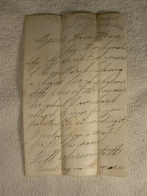
Letter
This letter describes a business transaction of an item essential to conducting a mill in the days of the pioneers. The horse was purchased from Francis Jones at Grasmere some 45 kilometres distant. Francis Jones and descendants were closely associated with the settlement of Grasmere (district) and 'The Union', a well-known pastoral property still in existence today.The conduct of business in the 19th century could be slow and arduous. Horses were an essential component of business and communication. Their labour was pivotal to success and so their physical soundness (or otherwise) was vital. The horse trade was open to manipulation by the unscrupulous, selling unfit animals. Veterinary care and treatment was primitive, so a buyer could not be confident of a positive result, despite (as in this case) Jones' assurances of the triviality of the injury and Knights' capabilities. Handwritten letter on paper folden in half - water stained.Grasmere. April 4th 1864. Messrs. Hamilton & Co. I beg to acknowledge the receipt of yours of the 29th March enclosing a cheque for [pound sign] balance of the price of the bay mare for which I am much obliged to you for your punctuality in sending it. I enclose you a receipt for the the (sic) same. With reference to the swelling on the mares leg it could only have been there a very short time before you purchased her. It can easily be removed if the proper remedies are applied. M. Knights the veterinary surgeon will give you medicine that will remove it for a trifle. Hoping the mare will give you ample satisfaction. I am scy. (sic) [sincerely] yours respecfully Francis Jones. mortlake mill hamilton transport communication francis jones grasmere michael knights veterinary surgeon -
City of Kingston
Photograph - Colour, 31 January 1993
Patterson Lakes is a suburb in the City of Kingston that is built one kilometre upstream of the mouth of the Patterson River. The area is bordered by the Patterson River and Eel Race Drain which enters the Kananook Creek. The suburb consists predominantly of newer housing developments and the tidal canal system of the development joins Port Phillip Bay. Patterson Lakes and the Kananook Creek were previously part of the extensive Carrum Carrum Swamp. The area was once a source of fish and eels for the Mayone-Bulluk clan of the Bunurong people. Over time the area was drained and in 1973 investigations commenced into the development of a unique residential area that would be built adjacent to canals and waterways. It was originally proposed to be known as "Gladesville". The development would give the suburb's homeowners access to Port Phillip Bay "from their back door". Circa 1974, the area was rezoned from rural to residential and named Patterson Lakes. Development has been continuous since the 1970s with construction of residential housing, schools, shopping centres, marinas, a hotel and library.Laminated colour aerial photograph of the Carrum and Patterson Lakes region within City of Kingston. This 1993 image includes Patterson River Secondary College, Roy Dore Reserve, Kananook Creek and Nepean Highway. The railway line can be seen as it veers inland from Eel Race Road, Seaford. The section of Ocean Reef Drive and Palm Beach Drive in Patterson Lakes appears to be a recent development with many spare blocks and new houses under construction.Black typed lettering on white adhesive label: 31.1.93 Black typed lettering on white adhesive label: 27E/7140 31/1/93 12.55 pm Black typed lettering on white label: 7140 Yellow round adhesive label located on left sidepatterson lakes, seaford, kananook creek, carrum carrum swamp, canals and waterways -
City of Kingston
Photograph - Colour, c. 1993
Patterson Lakes is a suburb in the City of Kingston that is built one kilometre upstream of the mouth of the Patterson River. The area is bordered by the Patterson River and Eel Race Drain which enters the Kananook Creek. The suburb consists predominantly of newer housing developments and the tidal canal system of the development joins Port Phillip Bay.Patterson Lakes and the Kananook Creek were previously part of the extensive Carrum Carrum Swamp. The area was once a source of fish and eels for the Mayone-Bulluk clan of the Bunurong people. Over time the area was drained and in 1973 investigations commenced into the development of a unique residential area that would be built adjacent to canals and waterways. It was originally proposed to be known as "Gladesville". The development would give the suburb's homeowners access to Port Phillip Bay "from their back door". Circa 1974, the area was rezoned from rural to residential and named Patterson Lakes. Development has been continuous since the 1970s with construction of residential housing, schools, shopping centres, marinas, a hotel and library.Laminated colour aerial photograph of the Carrum and Patterson Lakes region within City of Kingston. This 1993 image includes Patterson River Secondary College, Roy Dore Reserve, Kananook Creek and Nepean Highway. The railway line can be seen as it veers inland from Eel Race Road, Seaford. The section of Palm Beach Drive, Curlew Point Drive, Snapper Point Drive, Clipper Island and Myola Street in Patterson Lakes appears to be a recent development with many spare blocks and new houses under construction.patterson lakes, seaford, kananook creek, carrum carrum swamp, canals and waterways -
 Greensborough Historical Society
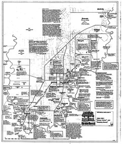
Map, Heidelberg: Historic River Landscape Assessment. Historical maps. Map D 1864 -1901 "Sleepy Hollow" and "Sleeping beauty", 1985c
Geographical area of c. 35 sq. kilometres marked with physical features such as major roads, rivers, vegetation and properties, with locations and notes on the increasing number of farms, orchards and vineyards that had been developed in addition to pastoral runs. Bounded by Shire of Diamond Valley to the North, Darebin Creek to the West, and Plenty River to the East.Black and white sketch on white paper. Second copy 600 x 430 cm printed in black on semi-opaque paperheidelberg, heidelberg - maps -
 Greensborough Historical Society
Book, Nillumbik Shire Council, 1997 Community Guide Nillumbik, 1997_
Guide to services provided by Nillumbik Shire Council. Nillumbik Shire is located 25 kilometres north-east of Melbourne and the southern boundary is the Yarra River. The south of Nillumbik is predominantly urban, with commercial centres at Eltham and Diamond Creek. The north of the municipality includes significant natural features like Kinglake National Park and Sugarloaf ReservoirAnnual guide to services in Nillumbik. 64 pages. Cover is pale yellow with colour drawings. nillumbik shire council, handbooks -
 Greensborough Historical Society
Book, Nillumbik Shire Council, 1998 Community Guide Nillumbik, 1998_
Guide to services provided by Nillumbik Shire Council. Nillumbik Shire is located 25 kilometres north-east of Melbourne and the southern boundary is the Yarra River. The south of Nillumbik is predominantly urban, with commercial centres at Eltham and Diamond Creek. The north of the municipality includes significant natural features like Kinglake National Park and Sugarloaf ReservoirAnnual guide to services in Nillumbik 72 pages. Cover has white background and some 3-D artwork.nillumbik shire council, handbooks -
 Greensborough Historical Society
Book, Nillumbik Shire Council, 1999 Community Guide Nillumbik, 1999_
Guide to services provided by Nillumbik Shire Council. Nillumbik Shire is located 25 kilometres north-east of Melbourne and the southern boundary is the Yarra River. The south of Nillumbik is predominantly urban, with commercial centres at Eltham and Diamond Creek. The north of the municipality includes significant natural features like Kinglake National Park and Sugarloaf ReservoirAnnual guide to services in Nillumbik76 pages, illus. Cover has photographs of local people and title in white on orange background.nillumbik shire council, handbooks -
 Greensborough Historical Society
Book, Nillumbik Shire Council, Nillumbik Community Guide 2000/2001, 2000-2001
Guide to services provided by Nillumbik Shire Council. Nillumbik Shire is located 25 kilometres north-east of Melbourne and the southern boundary is the Yarra River. The south of Nillumbik is predominantly urban, with commercial centres at Eltham and Diamond Creek. The north of the municipality includes significant natural features like Kinglake National Park and Sugarloaf ReservoirAnnual guide to services in Nillumbik76 pages, black and white illustrations. Cover has a collage of local children with title in white on mid-blue background.nillumbik shire council, handbooks -
 Greensborough Historical Society
Map, Heidelberg. Historic River Landscape Assessment. Historical maps: Map C 1851-1863. "The Garden of the colony", 1985c
Geographical area of around 35 sq. kilometres marked with physical features such as major roads, vegetation and properties, with locations and notes of the increasing number of farms, gardens orchards and vineyards which had become established in addition to pastoral runs. Bounded by Shire of Diamond Valley to the North, Darebin Creek to the West and Plenty River to the East.Black and white sketch map on white paperheidelberg, heidelberg - maps -
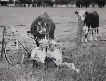 Vision Australia
Photograph (item) - Image, 1250 km bike ride around Victoria
Two riders in the 1250 kilometre ride around Victoria take a rest stop beside a field. Their tandem bike leant against the barbed wire fence, they sit in long grass with a drink bottle held by the male rider. A cow has wandered over and, unbeknownst to the riders, begins to nibble upon the bike seat at the rear. 1250 KM ride around Victoriaassociation for the blind, fundraising -
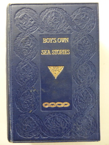 Warrnambool and District Historical Society Inc.
Book, Boy's own sea stories, Early 20th century
This book of sea stories belonged to C. Simpson of ‘Elm Bank’, Wangoom. Charles Simpson was a farmer at Wangoom in the 1860s. The township of Wangoom is about ten kilometres from Warrnambool. Charles Simpson was the brother of George Simpson of Nullawarre and William Simpson who had a drapery store in Warrnambool. The owner of the book would be a descendant of one of these early settlers. This book is of interest as it belonged to a member of the Simpson families, several of whom were early settlers in the Warrnambool district. This is a hard cover book of 424 pages. The cover is dark blue with gold lettering and gold scroll work. The book has a preface, 42 chapters of sea stories and, at the back of the book, several pages of advertisements for other books published by Ward, Lock and Co. There are many black and white sketches scattered throughout the text. The inscriptions are handwritten in black ink. ‘C. Simpson, Elm Bank, Wangoom’ (3 entries) simpson families of 19th century, warrnambool and district -
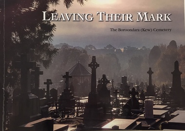 Kew Historical Society Inc
Book, Friends of Boroondara (Kew) Cemetery, Leaving their mark : a tribute to some of those who are memorialised in the Boroondara (Kew) Cemetery, est 1958, 2020
xii, 108 pages : illustrations, portraits ; 21 x 30 cmnon-fictionburials -- boroondara general cemetery, funerary monuments -- kew (vic), cemeteries -- victoria -- kew -- history, kew (vic.) -- biography -
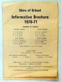 Orbost & District Historical Society
brochures, Snowy River Mail as "Mail" Print, Shire of Orbost Information Brochure, December 1970
The Shire of Orbost was a local government area about 380 kilometres east of Melbourne, the state capital of Victoria, Australia. The shire covered an area of 9,347 square kilometres ), and existed from 1892 until 1994. Originally, Orbost was part of the Bairnsdale Road District which was created on 30 April 1867. Splitting away as part of the Shire of Tambo in 1882, Orbost was first incorporated as a shire in its own right as the Shire of Croajingolong on 30 May 1892. It received its present name on 17 February 1893. On 3 January 1913 part of its western riding was annexed to Tambo as its Cunninghame Riding. On 2 December 1994, the Shire was abolished, and merged with City and Shire of Bairnsdale, Shire of Tambo, most of Shire of Omeo and the Boole Boole Peninsula from Shire of Rosedale into the Shire of East Gippsland This is a useful research tool.Two copies of a triple fold paper brochure. It is titled"Shire of Orbost Information Brochure" in black print. It contains the names of councillors, staff, the work program and budget.shire-of-orbost -
 Orbost & District Historical Society
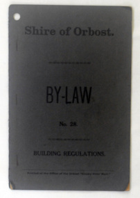
booklet, Snowy River Mail, Shire of Orbost By Laws No 28, 1920's
This booklet contains by law No 28 pertaining to building regulations. The Shire of Orbost was a local government area about 380 kilometres east of Melbourne, the state capital of Victoria, Australia. The shire covered an area of 9,347 square kilometres ), and existed from 1892 until 1994. Originally, Orbost was part of the Bairnsdale Road District which was created on 30 April 1867. Splitting away as part of the Shire of Tambo in 1882, Orbost was first incorporated as a shire in its own right as the Shire of Croajingolong on 30 May 1892. It received its present name on 17 February 1893. On 3 January 1913 part of its western riding was annexed to Tambo as its Cunninghame Riding. On 2 December 1994, the Shire was abolished, and merged with City and Shire of Bairnsdale, Shire of Tambo, most of Shire of Omeo and the Boole Boole Peninsula from Shire of Rosedale into the Shire of East Gippsland. This item is a useful research tool.A dark grey, stapled, paper covered booklet with title "Shire of Orbost By Law No 28" in black print. -
 Orbost & District Historical Society
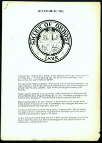
information sheet, Welcome to the Shire of Orbost, 1992
This was possibly produced for an open day in the centenary year. The Shire of Orbost was a local government area about 380 kilometres east of Melbourne. The shire covered an area of 9,347 square kilometres and existed from 1892 until 1994. Originally, Orbost was part of the Bairnsdale Road District which was created on 30 April 1867. Splitting away as part of the Shire of Tambo in 1882, Orbost was first incorporated as a shire in its own right as the Shire of Croajingolong on 30 May 1892. It received its present name on 17 February 1893. On 3 January 1913 part of its western riding was annexed to Tambo as its Cunninghame Riding. On 2 December 1994, the Shire was abolished, and merged with City and Shire of Bairnsdale, Shire of Tambo, most of the Shire of Omeo and the Boole Boole Peninsula from Shire of Rosedale into the Shire of East Gippsland. This is a useful reference tool.Two stapled pages of printed information. On the front page is the logo of Orbost Shire Council. There is information on the role of the Shire Councillors for 1992/93. It has a map of the council building.orbost-shire-council -
 Warrnambool and District Historical Society Inc.
Crockery, Chinese mugs x 2 'Miura', Late 20th century
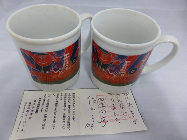
These cups come from Miura in Japan. Miura is the sister city of Warrnambool and is situated on the Miura Peninsula 50 kilometres south of Tokyo. It has a population of 56,000 people and is the centre of a fishing industry with some vegetable produce. The sister city ties with Warrnambool date from 1992 when the Warrnambool Miura Friendship Committee was formed and the cities share in cultural exchanges. These cups are of interest as a memento of the ties between the city of Warrnambool and the city of Miura in Japan. These white china cups come from Miura in Japan. They have the name ‘Miura’ in blue cursive script on one side and on the other side is a multi-coloured image of a boat with fish and fishermen. The cups also have Japanese writing on the bottom edge. Also with the cups is what looks like a receipt for the purchase of the cups in Japanese writing. ‘Miura’ warrnambool city council, miura, japan -
 Warrnambool and District Historical Society Inc.
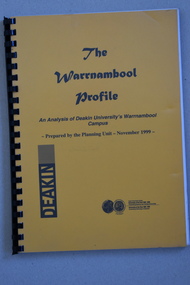
Booklet Lettering Book, Deakin University Planning Unit, The Warrnambool Profile – An Analysis of Deakin University’s Warrnambool Campus, 1999
This booklet was prepared in 1999 by the Planning Unit of Deakin University. It gives current data on the campus and projections and suggestions for the future. The Warrnambool Campus of Deakin University was established in 1990 after a merger with the Warrnambool Institute of Advanced Education which was already on the site that the university still occupies. This is Sherwood Park, a 94 hectare site on the Princes Highway, five kilometres from Warrnambool.This booklet is of some interest as it contains information on the Warrnambool Campus of Deakin University ten years after it was first established. This is a soft cover booklet of 179 pages. It has an orange front cover and a black back cover with black printing and a plastic over-sheet. The booklet has printed information, tables and graphs. It has black plastic spiral binding. deakin university, warrnambool campus -
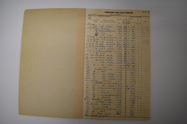 Warrnambool and District Historical Society Inc.
Ledger, Nullawarre Post Office, c.1960
This ledger came from the Nullawarre Post Office and was in use from 1967 to 1970. Nullawarre is a small settlement 25 kilometres south east of Warrnambool. European settlers first came to the Nullawarre district in the late 1860s and the area is largely agricultural. Charles and Vida Williams were the Post Master and Post Mistress at the Nullawarre Post Office in the mid 20th century.This ledger is of interest as it was used in the Nullawarre Post Office in the mid 20th century and is an example of business practices during that time. This is a ledger or booklet - a Complaint and Fault Register from the Nullawarre Post Office. It has a thick cardboard cover with green binding. The pages are ruled with black lines and black printed headings. The entries are handwritten in blue ink and pencil and some date stamps have been used. Most pages are blank. The corners of the ledger are slightly damaged. nullawarre post office, history of warrnambool -
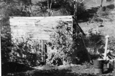 Greensborough Historical Society
Photograph - Digital image, Outhouse, Willis Vale, 1920c
This photograph shows one of the out buildings at 'Willis Vale', a property owned and farmed by the Partington family from the 1870s. The derelict Willis Vale house was destroyed in 1964 when a fire originating from North Plenty Gorge - Kurrak Road - was lit by two teenage boys and made its way several kilometres down to Partington's Flat Greensborough.The hoe of a pioneer Greensborough family.Digital copy of black and white photograph.willis vale, partington family