Showing 811 items
matching maps and sections
-
 Whitehorse Historical Society Inc.
Map, Nunawading Planning Scheme, 7/06/1994 12:00:00 AM
... maps ...Local Section maps 1 - 4 with index. Geographical information system land Information Branch. Scale 1:10,000 Shows zoning under planning scheme.Local Section maps 1 - 4 with index. Geographical information system land Information Branch. Scale 1:10,000 Shows zoning under planning scheme.Local Section maps 1 - 4 with index. Geographical information system land Information Branch. Scale 1:10,000 Shows zoning under planning scheme.blackburn, blackburn north, blackburn south, forest hill, heatherdale, maps, nunawading, vermont, vermont south, town planning, burwood east, laburnum -
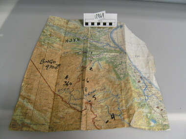 National Vietnam Veterans Museum (NVVM)
Map
A very damaged well used map which has been jointed together. It appears to be Northern Section of vietnam with numbers written in black texta (Hack, Bingo 9700) on front.On back of map hand written "Mission into the North. Planned both directions".Topagraphical Mapmap, alan reed -
Bendigo Historical Society Inc.
Map - BENDIGO GOLD FIELD GEOLOGICAL MAP
Geological map of the Bendigo Gold Field showing stratigraphical zones. Map in two sections, colour coded showing anticlines, synclines, shafts, fault lines, fossils. Signed by H. Herman. This map forms part of the Geological Survey of Victoria, Structure of Bendigo Goldfield report, No. 47, 1923. H.Herman, late Director of Geological Survey.Geological Survey Victoriabendigo, gold mining, geological map -
Beechworth Cemetery Trust
Map - Beechworth Cemetery reproduction of original map -Secretary copy, Beechworth Cemetery
Reproduction map displaying all grave sites in Beechworth Public Cemetery. Rotunda, fountain, nursery, memorial wall, pioneer sectionmap displays the plan of grave sitesLaminated Photocopy of original cemetery map with additional information hand-written on the map. All graves at the cemetery set out in denominational sections with hand-written information on additional graves added to sections in Roman Catholic A & C, Church of England A-F, Presbyterian A-C, Methodist/Uniting B and Wesleyan A. Multidenominational hand-written note on Jews section with Trust Minutes 4.7.'83 written next to this addition. Additions hand-drawn of fountain, memorial wall, nursery and pioneer cemetery.rotunda, fountain, nursery, memorial wall, pioneer section, graves, chinese section, un-numbered grave sites, cemetery -
Beechworth Cemetery Trust
Map - Beechworth Cemetery reproduction of original map, Beechworth Cemetery Reproduction - Treasurer copy
Reproduction map displaying all grave sites in Beechworth Public Cemetery. Rotunda, fountain, nursery, memorial wall, pioneer sectionmap displays the plan of grave sitesLaminated Photocopy of original cemetery map with additional information hand-written on the map. All graves at the cemetery set out in denominational sections with hand-written information on additional graves added to sections in Roman Catholic A & C, Church of England A-F, Presbyterian A-C, Methodist/Uniting B and Wesleyan A. Multidenominational hand-written note on Jews section with Trust Minutes 4.7.'83 written next to this addition. Additions hand-drawn of fountain, memorial wall, nursery and pioneer cemetery.rotunda, fountain, nursery, memorial wall, pioneer section, graves, chinese section, un-numbered grave sites, cemetery -
Beechworth Cemetery Trust
Map - Beechworth Cemetery reproduction of original map - On site in Rotunda, Beechworth Cemetery
Reproduction map displaying all grave sites in Beechworth Public Cemetery. Rotunda, fountain, nursery, memorial wall, pioneer sectionmap displays the plan of grave sitesLaminated Photocopy of original cemetery map with additional information hand-written on the map. All graves at the cemetery set out in denominational sections with hand-written information on additional graves added to sections in Roman Catholic A & C, Church of England A-F, Presbyterian A-C, Methodist/Uniting B and Wesleyan A. Multidenominational hand-written note on Jews section with Trust Minutes 4.7.'83 written next to this addition. Additions hand-drawn of fountain, memorial wall, nursery and pioneer cemetery.rotunda, fountain, nursery, memorial wall, pioneer section, graves, chinese section, un-numbered grave sites, cemetery -
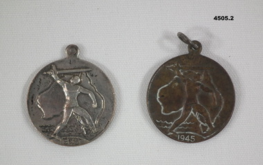 Bendigo Military Museum
Memorabilia - VICTORY MEADALLION 1945, c.1945
.1) .2) Medallion, metal, circular with a section at top for a ring, front face has depiction map of Australia with a figure holding a sword overhead, year date at bottom, rear has a styalized map of the World, , a small depiction of a boat, whale, writing stamped in.On front, "1945", on rear, "Victory Medal"medallions, victory 1945 -
Glenelg Shire Council Cultural Collection
Book, WARD LOCK AND CO LIMITED LONDON, The Holy bible, 1905
The Canterbury Emerald Teacher's Bible. Bound in black leather. Contains a section of black and white and coloured photos and maps of Biblical sites. 'Holy Bible ' in gold print on spinereligious text, religion, bible, teacher -
Glenelg Shire Council Cultural Collection
Map - Map - Western Victoria, n.d
Fold-out map of the western section of Victoria- Melbourne to Mt. Gambier and north to NSW border. Has been detached from its cover and glued to brown paper.map, western victoria, melbourne, mount gambier, victoria, south australia -
Whitehorse Historical Society Inc.
Map, Cadastral Map System, 2005
Land Victoria map of section of Blackburn North.Land Victoria map of section of Blackburn North, inc. Middleborough Road, Joseph Street and Chapman Street. Scale: 1:1500. With Lot Nos. and block frontage dimensions.Land Victoria map of section of Blackburn North. middleborough road, blackburn north, joseph street, blackburn north, chapman street, blackburn north -
Linton Mechanics Institute and Free Library Collection
Book - Novel, Dobson, Kenneth Austin, Mail train : a novel, 1946
Detective fiction set in Tanganyika.240 p. : frontispiece illustration - map of central Africa. Green cover, section of original dust jacket pasted to front, with images of butterflies clustering around a bright light.fictionDetective fiction set in Tanganyika.fiction, kenneth austin dobson, africa - fiction -
 Glen Eira City Council History and Heritage Collection
Map - Map, zoning, Metropolitan Town Planning Commission, "DISTRIBUTION AND USE OF EXISTING PROPERTY. MAP NO. 6.", 1929
The map titled: “Distribution and use of Existing property map No. 6” (Metropolitan Town Planning Commission Melbourne and Suburbs) is of historical significance. It is listed on page 168 of Chapter 4 the Zoning section of the "Plan of General Development Melbourne Report of the Metropolitan Town Planning Commission 1929" - Melbourne's first strategic plan. Map No. 6 is mentioned throughout Chapter 4 of the 1929 Report. It states on page 156 that this Map was created to graphically illustrate the data collected by the Planning Commission. The Map illustrates the general distribution of uses of existing property throughout the metropolitan area. The coloured sections show the areas which were developed or were in the process of development in 1929. The colours indicate the distribution of uses in the developed areas. The pink coloured areas, which include Caulfield, were almost completely residential.1929, metropolitan town planning commission, melbourne, suburbs -
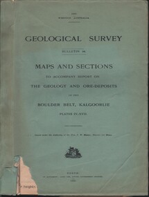 Bendigo Historical Society Inc.
Document - MCCOLL, RANKIN AND STANISTREET COLLECTION: MAPS AND SECTIONS KALGOORLIE, 1929
Document: MCCOLL, RANKIN AND STANISTREET: green cover book Bulletin 94, Maps and Sections to accompany report on the geology and ore deposits of the Boulder Belt, Kalgoorlie. Plages IV - XV11.Government printer, Perthorganization, business, kalgoorlie, mccoll, rankin and stanistreet, kalgoorlie, maps and sections -
 Ringwood and District Historical Society
Document - Subdivision Map, Part of Crown Sections 18, 19, 24 & 25, Parish of Warrandyte, County of Evelyn, Vol 5228 Fol 472 - 1926. (Park Orchards, Victoria)
... Part of Crown Sections 18, 19, 24 & 25, Parish of ...A3 and A4 sized photocopies showing map section of land title showing streets, easements and allotment numbers, some with handwritten names and pricing notations circa mid 1950s.Map includes Valley Road, Granard Avenue, Park Road, Arundel Avenue, Hylton Avenue, Aviemore Avenue, Bowmore Avenue, Hopetoun Road, Colin Avenue, Daintree Avenue, Brucedale Crescent, Feversham Avenue, Ennismore Crescent, Iona Grove, Elgin Crescent and Gosford Crescent, Park Orchards, Victoria. -
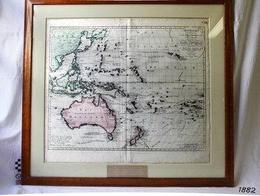 Flagstaff Hill Maritime Museum and Village
Map, Australien (Sudland) auch Polynesien oder Inselwelt, insgemein der funfte Welltheil, c.1990
This map is a reprint of Johann (Johannes) Walch’s “Australien (Sudland) auch Polynesien oder Inselwelt, insgemein der funfte Welltheil”, published in 1802. It shows Australia, New Zealand, South East Asia and the Pacific Islands shows a large number of places names, many of which have changed since the map was drawn. The map includes the routes and dates of the voyages of Tasman, Cook, Bougainville, Carteret, Byron, and others up to 1802. The shapes of the lands on this early map show that some of the areas had not yet been charted. The map was donated to Flagstaff Hill Maritime Village in April 1990 by the Group Study Exchange Team from Rotary District 233, Sweden. It was framed and presented by Rotary District 978 and presented by Barry Lange, the Governor of District 978 in 1989-90. (District 978, Geelong East, is now District 9780.) Johann (Johannes) Walch Johann Walch, painter and engraver, was born in 1757. He was well known for creating miniature portraits. He gained his training in Geneva, Venice and Rome. His publications include atlases and sheet maps, many of which were reprinted after his death in 1816. This reprint of an 1802 is significant for its historical and geographical contant, showing the voyages of many early explorers to the southern regions of the world including Australia. It also shows the early names used for countries and towns and is a valuable reference to historical interpretation. The map itself is a fine example of hand drawn and hand coloured maps of the early 19th century, the method of production, detail included, layout, symbols and so forth.Map, reprint of Johann (Johannes) Walch’s “Australien (Sudland) auch Polynesien oder Inselwelt, insgemein der funfte Welltheil “, first published by in Ausburg in 1802. The image on this Map No 5B, shows Australia and the south Pacific. The timber framed, glass covered, printed and coloured map was created in two sections and joined. Brass plaque at base of map states that the map was presented to Flagstaff Hill by Rotary International in April 1990. Feint lines used for aligning lettering can be seen on the map and there are large erased letters such as a “D” and “S” that are almost obscured.Plague “ROTARY INTERNATIONAL / THE MAP WAS DONATED BY THE GROUP STUDY EXCHANGE TEAM / FROM ROTARY DISTRICT 233 SWEDEN IN APRIL 1990 / AND WAS FRAMED AND PRESENTED BY ROTARY DISTRICT 978 / BARRY LANGE – GOVERNOR DISTRICT 978 1989/90” Stamped on back “ELLIMINOOK FRAMES / MRS. JILL FALKINER / ELLIMINOOK / BIRREGURRA, VIC. 3242 / PHONE: (052) 36 2080” flagstaff hill, warrnambool, shipwrecked coast, flagstaff hill maritime museum, maritime museum, shipwreck coast, flagstaff hill maritime village, great ocean road, australien (sudland) auch polynesien oder inselwelt, insgemein der funfte welltheil, johann (johannes) walch, cartographer johann (johannes) walch, ausburg publisher johann (johannes) walch, johann (johannes) walch map number 5b, 1802 map of australia and south pacific, rotary international group study exchange team, rotary district 233 sweden, elliminook frames, voyages of tasman, voyages of cook, voyages of bougainville, voyages of carteret, voyages of byron, barry lange, painter of miniature portraits johann (johannes) walch -
 Bacchus Marsh & District Historical Society
Map, The Unique Advertising Combine, The Unique Combine's New Map of the Shire of Bacchus Marsh, 1890
This map was one of a number of similar maps produced for advertising purposes by a company called, 'The Unique Advertising Combine'. The company was located in Melbourne on Queens Walk. A brief item in the Bacchus Marsh Express newspaper on 29 March 1890 , page 2, indicated that subscribers to the Bacchus Marsh Express could obtain a copy of this map in the next issue of that newspaper. On the map is the detail that it was compiled by W.H. Bonney from official records supplied by D. A. Little, hire Secretary, (of Bacchus Marsh Shire).This map with its accompanying illustrations of local businesses and shops in Bacchus Marsh is an important documentary and visual snapshot of the town and district of Bacchus Marsh in the later part of the nineteenth century. The illustrations for some of the local businesses are the only known visual record of those particular buildings. The map is a rare surviving example of the material produced by The Unique Advertising Combine. Another similar example for the Shire of Mornington is held by the State Library of Victoria,A map of the Shire of Bacchus Marsh produced in March 1890. The map is mounted on a board and enclosed within a timber frame. The map includes an inset detail section showing the central part of the township of Bacchus Marsh including the main shopping and business streets. Land holdings with the first European land holders names indicated are included on the map. Rivers, creeks, major roads and the railway line are also shown on the map. Around the edges of the map are illustrated advertisements mostly for Bacchus Marsh businesses but which also includes some businesses located in Melbourne. maps bacchus marsh shire, shops bacchus marsh -
 Warrnambool and District Historical Society Inc.
Documents Maps (3) - Warrnambool Town Allotments, City of W'bool Parish of Wangoom Country of Villiers, 1948
These maps were produced in 1948 and they contain maps of allotments within the city of Warrnambool, including the Central Business District, up to 1948. The details given on each allotment show the allotment and section numbers, the measurement in acres, the name of the original purchaser of the lot and the date of the first sale. The Warrnambool and District Historical Society owns several copies of these maps but these ones are originals.These three maps are of great significance because they give the names of land purchasers in Warrnambool from the date of the first land sales in 1847. They are a most valuable research tool and can be scanned and photocopied etc.These are three sheets of cream paper pasted on to linen. The sheets have black and white printing and map work. Some of the edges are a little frayed and there is some staining, particularly on the backs of the sheets.‘City of Warrnambool Parish of Wangoom County of Villiers Sheet 1’ ‘City of Warrnambool Parish of Wangoom County of Villiers Sheet 2’ ‘City of Warrnambool Parish of Wangoom County of Villiers Sheet 3’city of warrnambool, warrnambool maps, warrnambool town allotments 1948, land purchases -
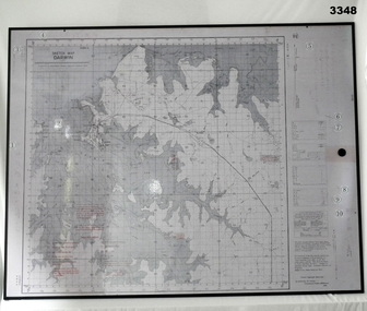 Bendigo Military Museum
Map - MAP, MOUNTED, WW2, Possible pre WW2
This sketch map is a copy of the original found in Tokyo after the 1939 - 1945 War. Note that Japanese writing that has been added.Copy of Sketch Map of Darwin prepared by Australian Section Imperial General Staff. Mounted on board backing with laminated surface added, black border around edge, hanging strap on back. A detailed map of Darwin area giving convergence & time correction figures for artillery purposes.Top left words: “Sketch Map Darwin”map, darwin -
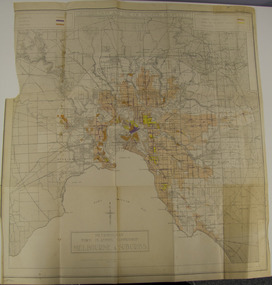
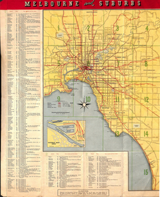
 Melbourne Tram Museum
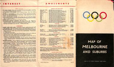
Map, Victorian Government Tourist Bureau, "Map of Melbourne and Suburbs", Jul. 1956
Map - .folded 12 sections full colour titled "Map of Melbourne and Suburbs". Issued at the time of the Melbourne Olympics by the Victorian Government Tourist Bureau. Has an index of Melbourne's suburbs, transport links, Places of Interest, Amusements, Facts of interest about Victoria. Major map shows the rail and tram lines, the detailed map of the CBD shows the buildings or locations referenced in the Tourist Guide to the City. Printed by the Victorian Railways - 2133-56trams, tramways, map, olympics, public transport, melbourne -
 Melbourne Tram Museum
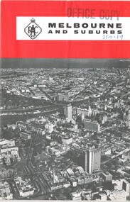
Map, Royal Automobile club of Victoria (RACv), "Melbourne and Suburbs", late 1960's
Map - folded 8 folds or sections, printed in two colours titled "Melbourne and Suburbs", published by the RACV late 1960's, giving a map of Melbourne and its suburbs, shows all tram and rail lines, highways, freeways under construction, has a detailed index and map of the city or CBD area, shows one way streets and churches, clubs etc.On front cover stamped "Office Copy" and hand written date of "28-1-69"trams, tramways, racv, melbourne, map, tramways, timetables -
 Bendigo Military Museum
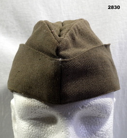
Headwear - CAP, FORAGE, C.WW2
Khaki forage cap, bottom section joins with Two copper coloured buttons with map of Australia surmounted by a crown, bearing legend, “Australia Military Forces” lined with brown cotton fabric.Handwritten on label inside: “182[3 or 5?] 8 / N McGregor”uniforms - army, costume - male - headwear, metalcraft - copperware, passchendaele barracks trust, forage -
 Bendigo Historical Society Inc.
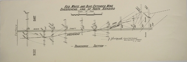
Map - RED WHITE AND BLUE EXTENDED MINE, 5/12/1940
Map: Transverse section of The Red, White and Blue Extended Mine, Sheepshead line of Reef, Bendigo. (9 Copies). By J.J. Caldwell, District Field Geologist, Mines Department Bendigo 5.12.1940map, bendigo, mining plan, red white and blue extended mine, sheepshead line of reef, mining , gold mines, j.j. caldwell -
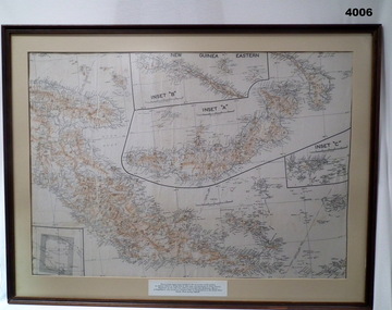 Bendigo Military Museum
Map - MAP, FRAMED
... Maps ...Printed on border under map: These escape maps were carried in the zip pockets of life jackets by fighter pilots in WW2. This map was presented to A.S.R on the 12/7/79 by Councillor Ian McKenzie, Mayor of Eaglehawk who served as a fighter pilot in 78 Sqn. in Sth. W. Pacific are during 1943-44.Map of eastern section of New Guinea. Black print on white background with mountain ridges in tan. Inset 'A' is New Britain. Inset 'B' is New Ireland. Inset 'C' is Manus Island. Map is mounted with cream border, brown wooden frame with glass front and fawn wooden backing.maps, ww2 -
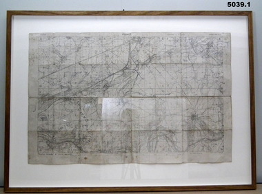
Whitehorse Historical Society Inc.
Map, Melbourne Metropolitan Area Base Map series. Sheet 214, c1960
... maps ...Map showing northern section of the City of Nunawading together with parts of Shire of Doncaster and Templestowe.Map showing northern section of the City of Nunawading together with parts of Shire of Doncaster and Templestowe. Shows roads, creeks, block numbers and contours at 5 feet vertical increments. Note on map: 'prepared ... from State Aerial Survey, January 1957 and Cadastral Survey information February 1959'.Map showing northern section of the City of Nunawading together with parts of Shire of Doncaster and Templestowe. maps, city of nunawading, shire of doncaster and templestowe -
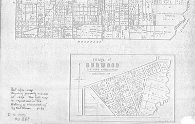 Whitehorse Historical Society Inc.
document - Map, Village of Burwood, 1892
Map on the village of Burwood.Village of Burwood : old name Ballyshanassy (with southern section of Nunawading). Area bounded by Chapman, Ireland and Evans Streets). Victorian Shire Map. co. 26 November 1892. Scale: 8 chains = 1 inch. The full map is reproduced in 'The History of Nunawading' by Niall Brennan, p. 62.Map on the village of Burwood.burwood, land settlement -
 Melbourne Tram Museum
Map, Tourist Development Authority of Victoria, "Melbourne Holiday City", c1963
Fold out map (8 sections 4 across x 2 deep), coloured of Melbourne's Tram and train routes, route numbers, rail lines, detailed for Melbourne and suburbs. On rear description is map of CBD and places of interest. Has contact details for cinemas, theatres and sporting venues.trams, tramways, melbourne, map, tram & train services, railways, mmtb -
 Bendigo Military Museum
Map - TRENCH MAPS, FRANCE, 38th BN ON THE SOMME, 1).2) 1918, .3) system generated
... Maps ...The story covers mostly men of C Coy 38th Bn as well as others to give a broader pictutre. Edgar Stanbury MM as a C Coy Scout retrieved the maps from Capt G.A Dutton who was KIA. Stanbury then proceeded to keep reconnoitering towards Clery until they reached trenches near Clery Copse. The photos relate to the following, Jack Grinton, Bert Grinton, Edgar Stanbury, C.E. Newton, D.T.Hull, A.E.Pegler, Albert Gilhooley, C.E.A.Dunn, Hugh Pippin, G.A.Dutton, C.J.Holmes, Capt Selleck, Major Maudsley, last photo is labelled “Past Clery Copse”. Jack Grinton No 1043 C Coy, refer Cat No 1280. Bert Grinton No 5024 C Coy, awarded DCM 31.8.1918, refer Cat No 1320P. Edgar Stanbury No 997 C Coy, awarded MM 1917, WIA 2nd occasion 31.8.1918, refer Cat No 5032.3P. Charles Newton No 951 C Coy, awarded MM 26/31.8.1918. David Hull No 904 C Coy, Gassed 24.8.1918. Albert Gilhooley No 890 C Coy, KIA 31.8.1918, refer Cat No 5047. Augustus Pegler No 967 C Coy, awarded MM 31.8.1918. Cyril Dunn No 3058 7th Reo’s C Coy, KIA 31.8.1918. Hugh Pippin No 1895 2nd Reo’s C Coy, WIA 2nd occasion 11.8.1918, refer Cat No 1502. George Dutton Lieut No 532 C Coy, KIA 29.8.1918. (Photo of his name on Map & note to Jack Grinton) Charles Holmes No 910 C Coy, KIA 24.8.1918. (Photo of original grave) Horace Selleck Capt C Coy, KIA 19.7.1918, refer Cat No 1515. (Photo of address book) Arthur Fyfe No 1841 2nd Reo’s C Coy, KIA 30.8.1918. (Photo of original grave) Arthur Maudsley Major D Coy, KIA 31.8.1918. (Photo of original grave) Fyfe, Maudsley and Duttons graves are in the one photo. Last photo labelled “Past Clery Copse” This is the area where Bert Grinton is awarded the DCM on 31.8.1918, photo was taken by his brother Jack. .1) Map of France, trenches corrected to 15.4.1918, 1/20,000, Sheet 62D N.E, covers an area from Ribemont to Bray. .2) Map of France, trenches corrected to 6.3.1918, 1/20,000, sheet 62C N.W, covers area from Suzanne to Mt St Quentin. Both maps follow the Somme River. .3) Photo - story covers the events relating to the two maps from July 17th. - Sept 1st 1918 on the Somme . There are 14 photos with the story, 3 sections make up the story, Map 1, Map 2 and then details on the advance, the men, casualties and other.maps, 38th bn, c coy, the somme -
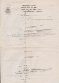 Bendigo Historical Society Inc.
Map - STRUGNELL COLLECTION: HUSTLER'S LINE OF REEF, BENDIGO
Map, Hustler's Line of Reef, Bendigo, Fortuna Hustler's Mine, Longitudinal Section. Plate No. 1V (4). NOTE--- Plates 4,8,13,29,26 & 31 form a Longitudinal Section from Fortuna Hustler's to Hustler's Consols Mine.Bulletin No 33 Signed H.A.Whitelaw. Drawing shows the vertical shaft descending to over 2228 feetUnderground Survey Office, Bendigo.map, bendigo, fortuna hustler's mine -
 Federation University Historical Collection
Map - Geological, Tallangatta, New South Wales: 1:250,000 Geological Series, SJ 55-3, 1966, 1966
Compiled by the Geological Survey of N.S.W., Division of Regional Geology. Topographical base compiled from Snowy Mountains Hydro Electrical Authority, Department of Lands, County maps and Snowy Lease Map. Other sheet adjoin this map. There are 13 formation sections grouped into 9 - Quaternary, Tertiary, Middle Devonian, Lower to Middle Devonian, Lower Devonian, Upper Silurian, Silurian, Upper Ordovician and Ordovician.Large coloured map showing geological features, faults, bores, rivers and mineral deposits.Scale of map, longitude and latitude, river names. "Tallangatta 1:250,00" written in black pen.tallangatta, new south wales, geological survey, topographical base, snowy mountains hydro electrical authority, department of lands, snowy lease map, department of mines, quaternary, tertiary, middle devonian, lower to middle devonian, lower devonian, uper siluran, silurian, upper ordovician, ordovician -
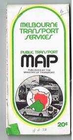 Melbourne Tram Museum
Map, Ministry of Transport, "Melbourne Transport Services Map - Tram, Train and Bus Services", 1975-1976
Fold out map (27 sections 9 across x 3 deep), coloured of Melbourne's Tram and Bus routes, route numbers, rail lines, detailed for the central part of Melbourne and insert section for Frankston. On rear description of routes, private bus routes and map of Melbourne metro lines. Has contact details for bookings and lost property etc. Priced 20c possible 1975-1976 - has 1041 and silver train on front cover.On front cover in ink "3" in top right hand corner and "4 G 33 " along bottom edge.trams, tramways, melbourne, map, tram & bus services, railways, mmtb, minister for transport