Showing 414 items matching " north kew"
-
 Kew Historical Society Inc
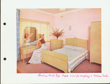
Print - Bedroom of the 'Laminex House', Brougham Street, Kew, 1956-1960
... and represented North Ward on Kew Council from 1952 to 1968. He... and represented North Ward on Kew Council from 1952 to 1968. He ...Hugh G Ferguson (1900–75) worked in Advertising as an account manager, and was campaign director for Arthur Rylah is Victorian politics. He organised the first major trade fairs at the Royal Exhibition Buildings after the Second World War, including a World Trade Fair. He built a home in Brougham Street and represented North Ward on Kew Council from 1952 to 1968. He was elected Mayor for the 1959-60 term.Advertising promotional photoshoot in the bedroom of the so-called 'Laminex House', in Brougham Street, Kew. The room was fitted out with laminex furniture to promote the brand and its products. This image was a later colourised version for an advertising campaign. The room was in the home of Cr and Mrs Hugh G Ferguson."Laminex Bird's Eye Maple used for laminating a bedroom suite"advertising -- laminex products, laminex, hugh g ferguson, houses -- brougham street (kew) -
 Kew Historical Society Inc
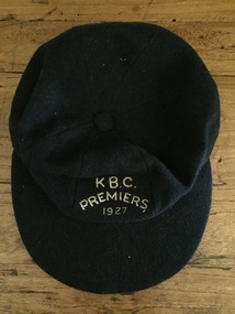
Uniform, K.B.C. Premiers 1927
... and after World War 2, North Kew which had now joined Kew... and after World War 2, North Kew which had now joined Kew ...The Victorian Baseball League was established in 1889 with the following clubs - MCC, Metropolitan, Richmond, Richmond Cricketers, Kew, Geelong, Fitzroy, The Age, Carlton, Coburg. MCC defeated Metropolitan for the first Premiership. By 1897 Kew had built up to six teams, but went into recess about the turn of the century. They reformed c.1906 and did not resume until 1926 under Captain/Coach Frank Littlefield. I think he was ex Hawthorn Baseball and/or Cricket club(s). They won the D Grade Premiership of 1926 and/or 1927 playing out of Victoria Park at 12 noon, and as a curtain raiser to either Kew or Kew District or East Kew Football Club and after World War 2, North Kew which had now joined Kew as a tenant. Team members were H.L. Barclay (ex Richmond), A. Brierley (ex Collingwood), H. Ely (ex Essendon), Frank Littlefield, J. Marshall and C. Robinson (ex Hawthorn-East Melbourne Cricket Club). In 1926, the KBC played against Caulfield, Fairfield, Fitzroy, Ivanhoe, Northcote, Prahran, University, Williamstown, YMCA. In 1927, Preston replaced Fairfield. A third team was formed post WW2 which played at Willsmere Park. The Reserves followed to Willsmere Park in 1963 and the Seniors in c.1970. Kew Council moved the club to a sub-standard Stradbroke Park No 2 Oval for the 1976 season and this proved to be the last for the club. Melbourne Baseball Club moved in for two seasons, but also moved when improvements to No 2 Oval were not made. They then moved to Macleay Park in a share arrangement with North Balwyn BC. Research: Ian Job, 2015A premiership cap awarded to Christopher Robinson of the Kew Baseball Club in 1927.Navy blue peaked baseball cap, embroidered in gold thread with K B.C. Premiers 1927sports uniforms, caps, premiership caps, baseball, -
 Kew Historical Society Inc
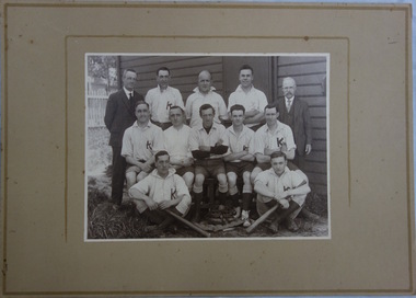
Photograph, Kew Baseball Club, c.1927
... and after World War 2, North Kew which had now joined Kew... and after World War 2, North Kew which had now joined Kew ...The Victorian Baseball League was established in 1889 with the following clubs - MCC, Metropolitan, Richmond, Richmond Cricketers, Kew, Geelong, Fitzroy, The Age, Carlton, Coburg. MCC defeated Metropolitan for the first Premiership. By 1897 Kew had built up to six teams, but went into recess about the turn of the century. They reformed c.1906 and did not resume until 1926 under Captain/Coach Frank Littlefield. I think he was ex Hawthorn Baseball and/or Cricket club(s). They won the D Grade Premiership of 1926 and/or 1927 playing out of Victoria Park at 12 noon, and as a curtain raiser to either Kew or Kew District or East Kew Football Club and after World War 2, North Kew which had now joined Kew as a tenant. Team members were H.L. Barclay (ex Richmond), A. Brierley (ex Collingwood), H. Ely (ex Essendon), Frank Littlefield, J. Marshall and C. Robinson (ex Hawthorn-East Melb Cricket Club). In 1926, the KBC played against Caulfield, Fairfield, Fitzroy, Ivanhoe, Northcote, Prahran, University, Williamstown, YMCA. In 1927, Preston replaced Fairfield. A third team was formed post WW2 which played at Willsmere Park. The Reserves followed to Willsmere Park in 1963 and the Seniors in c.1970. Kew Council moved the club to a sub-standard Stradbroke Park No 2 Oval for the 1976 season and this proved to be the last for the club. Melbourne Baseball Club moved in for two seasons, but also moved when improvements to No 2 Oval were not made. They then moved to Macleay Park in a share arrangement with North Balwyn BC. Research: Ian JobTeam photo of the Kew Baseball Club players and club officials and or supporters. The grandfather of the donor, Christopher Robinson has been identified as sitting in the middle row, 2nd from left.kew baseball club, victoria park -
 Kew Historical Society Inc
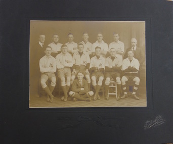
Photograph, The Burlington Studios, Kew Baseball Club, c. 1926
... and after World War 2, North Kew which had now joined Kew... and after World War 2, North Kew which had now joined Kew ...The Victorian Baseball League was established in 1889 with the following clubs - MCC, Metropolitan, Richmond, Richmond Cricketers, Kew, Geelong, Fitzroy, The Age, Carlton, Coburg. MCC defeated Metropolitan for the first Premiership. By 1897 Kew had built up to six teams, but went into recess about the turn of the century. They reformed c.1906 and did not resume until 1926 under Captain/Coach Frank Littlefield. I think he was ex Hawthorn Baseball and/or Cricket club(s). They won the D Grade Premiership of 1926 and/or 1927 playing out of Victoria Park at 12 noon, and as a curtain raiser to either Kew or Kew District or East Kew Football Club and after World War 2, North Kew which had now joined Kew as a tenant. Team members were H.L. Barclay (ex Richmond), A. Brierley (ex Collingwood), H. Ely (ex Essendon), Frank Littlefield, J. Marshall and C. Robinson (ex Hawthorn-East Melb Cricket Club). In 1926, the KBC played against Caulfield, Fairfield, Fitzroy, Ivanhoe, Northcote, Prahran, University, Williamstown, YMCA. In 1927, Preston replaced Fairfield. A third team was formed post WW2 which played at Willsmere Park. The Reserves followed to Willsmere Park in 1963 and the Seniors in c.1970. Kew Council moved the club to a sub-standard Stradbroke Park No 2 Oval for the 1976 season and this proved to be the last for the club. Melbourne Baseball Club moved in for two seasons, but also moved when improvements to No 2 Oval were not made. They then moved to Macleay Park in a share arrangement with North Balwyn BC. Research: Ian JobTeam photo of the Kew Baseball Club players and club officials and or supporters. The grandfather of the donor, Christopher Robinson has been identified as sitting in the back row, 2nd from left.kew baseball club, victoria park, christopher robinson -
 Kew Historical Society Inc
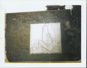
Photograph - Second World War Memorial, Kew Library, c.1960
... of the north side of Kew Library commemorating WW2 was funded... of the north side of Kew Library commemorating WW2 was funded ...George Henry Allen (8 February 1900 – 12 October 1972) was an Australian sculptor and teacher, an official war artist in the latter years of the Second World War. He served as an official war artist with the rank of lieutenant from December 1943, working at Port Moresby and the Australian War Memorial, retired February 1945. The plaque by George Allen on the exterior wall of the north side of Kew Library commemorating WW2 was funded by a bequest from the late Mrs Annie Anderson.One of two black and white snapshots (polaroid photos) of George Allen's sculpture at Kew Library. Mavis Rolley wrote about the memorial in 1980 as: This impressive piece of Sculpture, a memorial to the sacrifice of those who served in the Second World War, was completed in 1960 to coincide with the One Hundred Centenary Year of the City of Kew, and was unveiled on Anzac Day of that year by the Hon. A.G. Rylah, Chief Secretary, Deputy Premier of Victoria. Mr. George Allen, sculptor, submitted the winning design and through the contribution of a generous bequest of the late Mrs. Annie Anderson, a former resident of Kew, the Municipal Office was able to commission this gentleman’s work. The memorial is mounted on a wall of granite blocks and carved in Sydney Freestone, depicting a scene of war and loved ones at home.war memorials -- kew (vic.), memorials -- world war 2. -- kew (vic.), george henry allen, artworks -- kew library -
 Kew Historical Society Inc
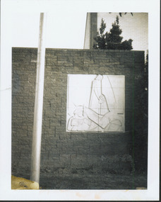
Photograph - Second World War Memorial, Kew Library, c.1960
... of the north side of Kew Library commemorating WW2 was funded... of the north side of Kew Library commemorating WW2 was funded ...George Henry Allen (8 February 1900 – 12 October 1972) was an Australian sculptor and teacher, an official war artist in the latter years of the Second World War. He served as an official war artist with the rank of lieutenant from December 1943, working at Port Moresby and the Australian War Memorial, retired February 1945. The plaque by George Allen on the exterior wall of the north side of Kew Library commemorating WW2 was funded by a bequest from the late Mrs Annie Anderson.One of two black and white snapshots (polaroid photos) of George Allen's sculpture at Kew Library. Mavis Rolley wrote about the memorial in 1980 as: This impressive piece of Sculpture, a memorial to the sacrifice of those who served in the Second World War, was completed in 1960 to coincide with the One Hundred Centenary Year of the City of Kew, and was unveiled on Anzac Day of that year by the Hon. A.G. Rylah, Chief Secretary, Deputy Premier of Victoria. Mr. George Allen, sculptor, submitted the winning design and through the contribution of a generous bequest of the late Mrs. Annie Anderson, a former resident of Kew, the Municipal Office was able to commission this gentleman’s work. The memorial is mounted on a wall of granite blocks and carved in Sydney Freestone, depicting a scene of war and loved ones at home.war memorials -- kew (vic.), memorials -- world war 2. -- kew (vic.), george henry allen, artworks -- kew library -
 Darebin Parklands Association
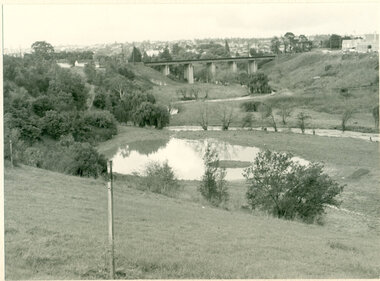
Rockbeare Park and Darebin Creek, August 1974, 1974
... Reid land on fore bank. View from the north with panorama... and Darebin Creek. Albion Reid land on fore bank. View from the north ...In 1972 Ivanhoe Progress Association planned to fill in the wetlands because they felt it bred mosquitos, and they obtained a grant for this work to take place. Darebin Parklands Association stormed the meeting to get this decision reversed, and the wetlands were never filled in.B&W photograph. Shows wetlands and Darebin Creek. Albion Reid land on fore bank. View from the north with panorama of Kew in the distance This item and all other Darebin Parklands Association archival material is now held by State Library Victoria (Accession No: YMS 13746). Please contact State Library Victoria if access is required. -
 Melbourne Tram Museum
Album - Robert Thomson Slide Collection, AETA Convention 1978 Melbourne
... Swanston - Flinders 24-3-78 - "Bulleen via North Kew" - route 202... Swanston - Flinders 24-3-78 - "Bulleen via North Kew" - route 202 ...Photo - see pdf file for further information. Number Brief Description RT175 St Kilda Carlisle St - tram 966 - "Kew Cotham Rd" - route 69 RT176 Pantograph W Class RT177 Z Class 91 Preston 28-3-78 - tram 91 - " Northcote Dundas St via High St" RT178 Z Class cars Preston 28-3-78 RT179 Wheel Transport Car 16W "Q" Class Preston 28-3-78 RT180 Z Class 51 Royal Park Res Track 27-3-78 - tram 51 -"Special" RT181 W6 - 990 - Glen Iris Terminus 26-3-78 "City" - route 6 RT182 w7-1007 Elizabeth Street Terminus 24-3-73 "Essendon Airport" - route 59 RT183 Z Class 51 Napier St Siding Essendon 27-3-78 - "City" RT184 Volvo Bus Swanston - Flinders 24-3-78 - "Bulleen via North Kew" - route 202 RT185 W6 - 878 Burwood Old Terminus 26-3-78 - "Spencer St" - route 74 RT186 W6 - 878 Burwood Old Terminus 26-3-78 - "Spencer St" - route 75 RT187 East Burwood Andrews Street 26-3-78 RT188 East Burwood Elgar Road 26-3-78 RT189 East Burwood Reservation Parer Street 26-3-78 RT190 East Burwood Terminus 26-3-78 RT191 East Burwood Terminus 26-3-78 RT192 "6" RT193 "5" RT194 "4" RT195 "3" RT196 "2" RT197 "1" Z Cars under constructionDemonstrates the work of Robert Thomson in photography, collection and/or production of slidesAssembled album in a black presentation folder of 23 colour slides, collected or produced by Robert Thomson. All photographs have been scanned and placed on the Museum's G drive. A list of all photographs with details has been compiled. melbourne, tramways, trams -
 Melbourne Tram Museum
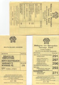
Ephemera - Timetable/s, Melbourne & Metropolitan Tramways Board (MMTB), "MMTB Bus Timetables", 1981 - 1984
... - Services via Templestowe, North Balwyn and Kew, Warrandyte... - Services via Templestowe, North Balwyn and Kew, Warrandyte ...Timetables for specific routes, day of week giving information on tram times at specific time points, route map, sections and fares and organisation address - 616 Little Collins St. Melbourne. All printed on yellow paper. .1 - Timetable for Box Hill via Shoppingtown and Templestowe, Doncaster bus services, dated July 1981 - routes 291, 297, 296, 293 and 271. .2 - Services via Templestowe, North Balwyn and Kew, Warrandyte and Newmans Rd - routes 276, 278 and 279 - July 1982 .3 - Services via East Doncaster, North Balwyn, Kew, Warrandyte, City, Shoppingtown - routes 277, 280, 281 and 268 - dated Jan. 1983 .4 - ditto as above, including Park Orchards and Donvale - routes 265, 262, 261, 260, 266 and 264 - dated Feb. 1983 .5 - North Altona - City Route 232 - April 1984 - issued by Metropolitan Transit with their logo. 6 - Garden City, Port Melbourne - City - Sept 1982 - routes 201, 202 7 - Sunshine - Footscray - City - Routes 230 and 231 - Jan. 1982 8 - North Altona - City - MMTB logo, route 232 - Nov. 1982 9 - East Kew, Box Hill, Doncaster - Express bus - Box Hill to City - routes 284, 270, 300 - April 1982 10 - Ringwood - Warrandyte, Park Orchards, Mitcham - routes 313, 31, 315 and 316 - Jan. 1983Yields information about MMTB Bus services early 1980s and 1 The Met badged item.Set of 9 MMTB and 1 MTA Bus timetables, folded sheets, 8 sections.trams, tramways, mmtb, timetables, melbourne, fares, east kew, box hill, doncaster, north altona, route 232, route 201, route 202, route 220, route 231, route 284, route 270, route 300, route 313, route 314, route 315, route 316 -
 Ruyton Girls' School
Photograph, [Miss Beatrice Henty in the Garden of Tarring], 1904
... of her family home Tarring, Selbourne Road, Kew. The north east... Road, Kew. The north east and south facades of the two story ...Beatrice Charlotte Henty was born 25 December 1867, married Graham Frederick Blandy in 1927 and died on 5 March 1950 in Toorak. She did not have any children. Miss Beatrice Henty was the daughter of Henry and Marion Henty. Mr Henry Henty and his wife Mrs Marion Anne Henty (nee McKellar) had ‘Tarring’, Kew built for their family in 1872, and resided there until the death of Marion Henty in 1919. ‘Tarring’ was then sold to Ruyton Girls’ School, and the School moved to the site, (now 12 Selbourne Rd, Kew) in 1920. ‘Tarring’ was renamed ‘Henty House’ by Ruyton Girls' School in honour of its original owners. Ruyton Girls' School was founded in 1878, Miss Beatrice Henty attended the School before 1888. The photograph is dated c.1904. Sepia toned photograph Miss Beatrice Henty in the garden of her family home Tarring, Selbourne Road, Kew. The north east and south facades of the two story brick house are visible in the photo. Beatrice Henty is standing in the garden wearing a long gown and a large hat. A gravel path curves across the lower left corner of the photograph. The photograph is mounted on card.ruyton girls' school, kew, beatrice henty, henry henty, marion henty, tarring, henty house, selbourne road, beatrice blandy, kew (vic), 1900s, 1904 -
 Melbourne Tram Museum
Photograph - Set of 11 Black and White photograph, Ken Flood, 18/04/1974 12:00:00 AM
... bound for North Kew. (Belford Road via Collingwood). Photo... bound for North Kew. (Belford Road via Collingwood). Photo ...Set of 11 black and white photographs sent to Keith Kings received from Ken Flood 4/6/1975. .1 - Bus No 203 1940 Leyland TD5c - Turning from Nicholson Street into Gertrude Street. - bound for Northcote. .2 - Bus No 201 1940 Leyland TD5c - In Nicholson Street at Albert Street - Photo. bound for Northcote .3.- Bus No 492 1943 Ford Austerity - at Queens Pde Clifton Hill - Note the Pram and Passenger bus sign by the front doorway. Photo not dated. .4 - Bus No 365 1948 OPS1 - Nicholson Street at Victoria Pde. bound for East Brunswick. Photo not dated. .5 - Bus No 325 1950 OPS4 - Nicholson Street at Victoria Pde. bound for East Brunswick. Photo not dated. Bus did not enter service until 1950. .6 - Bus No 500 1943 Ford Austerity - Marine Pde. Point Ormond. Note the Pram bus sign by the front door. .7 - Bus No 19 1938 Leyland Cub (diesel) with Preston Workshops body. - Lonsdale Street at William Street. W2 No 305 passes behind the bus. Late 1940's photo. .8 - Bus No 143 1940 Leyland TS8c drop enter - in Russell Street at LaTrobe Street bound for North Kew. (Belford Road via Collingwood). Photo not dated. .9 - Bus No 9 1938 Leyland Cub (diesel) with Preston Workshops body. - in Russell Street at LaTrobe Street bound for North Carlton .10 - Bus No 4 1938 Leyland Cub (Diesel) with Preston Workshops body - in Lonsdale Street at William Street. note destination not reset for the return trip. .11 - Bus No 150 1940 Leyland TS11c Drop enter - Nicholson Street at Victoria Pde. Photo not dated. Most of the photos dated 9/6/1949 unless noted otherwise. Notes on photos provided by Rod Atkins - see htd5860doc.pdfOn rear of the photos in ink; .1 - MMTB 203 9/6/49 - K Flood .2 - MMTB 201 - 9/6/49 - K Flood .3 - MMTB Ford #492 - K Flood .4 - MMTB #365 - K Flood .5 - MMTB #325 - K Flood .6 - MMTB #500 Pt Ormond 6/6/49 - K Flood .7 - MMTB #19 9/6/49 - K Flood .8 - MMTB #143 - K Flood .9 - MMTB #4 9/6/49, K Flood .10 - MMTB #4 9/6/49, K Flood .11 - MMTB #150 - K Floodtrams, tramways, buses, double deck buses, prams, mmtb buses, austerity buses, w2 class, tram 305, bus 203, bus 201, bus 492, bus 365, bus 500, bus 19, bus 143, bus 9, bus 4, bus 150, leyland, ford motor company, td5c class, ops1 class, ops4 class, ts8c class, cub class, ts11c class -
 Kew Historical Society Inc
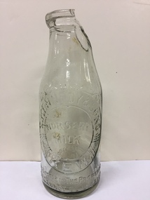
Container - Milk Bottle, Nursery Milk Bottle : Kennedy & Sons, Kew, Twentieth century
... Gordon Allberry Shepherdly, of Barnard street, North Kew, milk... Shepherdly, of Barnard street, North Kew, milk-carter, claiming ...Kennedy and sons, Roselea Dairy operated in Kew (<1930-1945>). In 1945 Thomas Kennedy, Michael Kennedy and Patrick John Kennedy traded as Kennedy and sons, Roselea Dairy at 80 Pakington St, Kew. (Victorian Government, 07 December 1945). Tom Kennedy, Jnr, and his wife, Lucy, lived at 109 Pakington St Kew. Tom Kennedy Jnr. died 02 November 1963. Lucy Kennedy died 28 November 1987. "CONTEMPT OF COURT. MILK-CARTER GUILTY. Breach of an Injunction. A Supreme Court writ has been issued by Thomas Kennedy, sen., Thomas Kennedy, jun., Patrick John Kennedy, and Michael Kennedy, trading as Kennedy and Sons, Rose Lea Dairy, against Gordon Allberry Shepherdly, of Barnard street, North Kew, milk-carter, claiming an injunction and damages. Plaintiffs carry on business at Pakington street. Kew, and Melville street, Hawthorn, and they claim In their writ an injunction restraining the defendant from soliciting or endeavouring to obtain the custom of people who were customers of plaintiffs when Shepherdly was employed by them under an agreement dated March 13 1928. Plaintiffs also claim damages. Mr Read (instructed by Messrs. Moule, Hamilton, and Derham) appeared for plaintiffs before Mr. Justice Macfarlan in the Practice Court yesterday, to ask for an order for the committal of Shepherdly to prison, or alternatively, for an order that plaintiffs be at liberty to Issue a writ of attachment against him for contempt of court in soliciting or endeavouring to obtain the custom of plaintiffs' customers. The affidavits set out that Shepherdly was employed by plaintiffs from March I3, 1928. until June 6. 1930. An Interlocutory injunction had been granted pending trial of the action for a permanent injunction. Shepherdly, who appeared in person yesterday, said that he had a sick wife and two children. He had not served any of the customers referred to since the granting of the injunction. He had passed them over to another man for whom he was working. Mr Justice Macfarlan - In doing that you have committed a breach of the injunction, and I have no alternative but to order that you be sent to gaol. I will make an order that you be committed to prison until further order of the Court. I will direct, however, that the order be not executed until Tuesday next. If you can then satisfy the Court that you have ceased to serve, or take any part in serving, the customers of Kennedy and Sons, the order will not be executed. (The Argus, 11 July 1930) Rare, if damaged milk bottle from an historic Kew dairyMilk bottle produced for and retailed by Kennedy & Sons Kew. The dairy operated under various names, and at one stage was described as the Rose Lea Dairy. The dairy was situated on the corner of Eglinton and Pakington Streets, Kew. "Kennedy & Sons / Kew / Nursery Milk / This bottle is the property of T.Kennedy & Sons, Kew/ and cannot be legally used by others."kennedy's dairy, kennedy and sons, dairies - kew (vic), milk bottles - kew - melbourne - victoria, thomas kennedy, michael kennedy -
 Kew Historical Society Inc
Map, MMBW, MMBW Plan No.39 Kew & Heidelberg, 1900-1910
... of Kew, bordered on its north by Wills Street and the Kew Lunatic... was then the north western section of Kew, bordered on its north by Wills ...The Melbourne and Metropolitan Board of Works (MMBW) was established by an act of the Victorian Parliament in 1890 to prepare for and to implement a sewerage and water reticulation system across what was then inner Melbourne, its surrounding and middle distance suburbs, including Kew. The MMBW was disbanded in 1991.The map collection of the Kew Historical Society has at its core the historic maps assembled and originally stored in the City Engineer's Department of the City of Kew. These include maps in a number of scales. The vast majority of maps were produced by the MMBW in the first two decades of the twentieth century, and are solid working maps, backed by linen for durability. These maps are historically significant to Kew, the City of Boroondara and to the history of the development of state utilities in Victoria. A number of the Kew maps have additional details added by former municipal officers, including the levels reached by various floods. As these were working documents, information was added to them long after the period of their initial production and distribution.Early map of part of the Borough of Kew, created in the first decade of the twentieth century, at a scale 160 ft to 1 inch. The map covers what was then the north western section of Kew, bordered on its north by Wills Street and the Kew Lunatic Asylum, in the west by the River Yarra [and the later added Yarra Boulevard] , by Princess Street in the East and Holroyd Street in the south. The map shows the extent of urban development by that time, prominent institutions and the outlines of built structures in the municipality. Contour lines were added in ink to the map at a later stage.MELBOURNE AND METROPOLITAN BOARD OF WORKS / PLAN NO. 39 / KEW & HEIDELBERGmelbourne & metropolitan board of works, mmbw maps, mmbw plans, borough of kew, cartography -
 Kew Historical Society Inc
Map, MMBW, MMBW Plan No.67 Kew, 1900-1910
... of Kew, bordered on its north by the Outer Circle Railway Spruzen... was then the north central part of Kew, bordered on its north by the Outer ...The Melbourne and Metropolitan Board of Works (MMBW) was established by an act of the Victorian Parliament in 1890 to prepare for and to implement a sewerage and water reticulation system across what was then inner Melbourne, its surrounding and middle distance suburbs, including Kew. The MMBW was disbanded in 1991.The map collection of the Kew Historical Society has at its core the historic maps assembled and originally stored in the City Engineer's Department of the City of Kew. These include maps in a number of scales. The vast majority of maps were produced by the MMBW in the first two decades of the twentieth century, and are solid working maps, backed by linen for durability. These maps are historically significant to Kew, the City of Boroondara and to the history of the development of state utilities in Victoria. A number of the Kew maps have additional details added by former municipal officers, including the levels reached by various floods. As these were working documents, information was added to them long after the period of their initial production and distribution.Early map of part of the Borough of Kew, created in the first decade of the twentieth century, at a scale 160 ft to 1 inch. The map covers what was then the north central part of Kew, bordered on its north by the Outer Circle Railway Spruzen and Beresford Avenues, in the west by Princess Street, in the south by High Street, and in the east by (about) Belford Road. The map shows the extent of urban development by that time, prominent institutions and the outlines of built structures in the municipality. Contour lines were added in ink to the map at a later stage.MELBOURNE AND METROPOLITAN BOARD OF WORKS / PLAN NO. 67 / KEW melbourne & metropolitan board of works, mmbw maps, mmbw plans, borough of kew, cartography -
 Kew Historical Society Inc
Map, MMBW, MMBW Plan No.68 Kew, 1900-1910
... of Kew, bordered in the north by Oak Avenue, in the west... was then the north central part of Kew, bordered in the north by Oak Avenue ...The Melbourne and Metropolitan Board of Works (MMBW) was established by an act of the Victorian Parliament in 1890 to prepare for and to implement a sewerage and water reticulation system across what was then inner Melbourne, its surrounding and middle distance suburbs, including Kew. The MMBW was disbanded in 1991.The map collection of the Kew Historical Society has at its core the historic maps assembled and originally stored in the City Engineer's Department of the City of Kew. These include maps in a number of scales. The vast majority of maps were produced by the MMBW in the first two decades of the twentieth century, and are solid working maps, backed by linen for durability. These maps are historically significant to Kew, the City of Boroondara and to the history of the development of state utilities in Victoria. A number of the Kew maps have additional details added by former municipal officers, including the levels reached by various floods. As these were working documents, information was added to them long after the period of their initial production and distribution.Early map of part of the Borough of Kew, created in the first decade of the twentieth century, at a scale 160 ft to 1 inch. The map covers what was then the north central part of Kew, bordered in the north by Oak Avenue, in the west by the Yarra River and Connor's Creek, in the south by Beresford and Carnegie Avenues, and in the east by Glass's Creek and Burke Road. The map shows the extent of urban development by that time, prominent institutions and the outlines of built structures in the municipality. Contour lines and the levels of historic floods were added in ink to the map at a later stage.MELBOURNE AND METROPOLITAN BOARD OF WORKS / PLAN NO. 68 / KEW melbourne & metropolitan board of works, mmbw maps, mmbw plans, borough of kew, cartography -
 Kew Historical Society Inc
Archive (Sub-series) - Subject File, Electoral Rolls (Kew), 1958
... Electoral Rolls for the Subdivisions of Kew and Kew North, 1986-7... Electoral Rolls for the Subdivisions of Kew and Kew North, 1986-7 ...City of KewReference, Research, InformationSecondary Values (KHS Imposed Order)Subject file (and the library) containing original copies of voter and or electoral rolls. These include, in date order: 1971 - City of Kew Voters Roll for College Ward, 1972 - City of Kew Voters Roll for Central Ward, College Ward, Prospect Ward, Studley Park Ward, 1977 - Victorian Government Electoral Rolls for the Subdivisions of Kew and Kew North, 1986-7 - City of Kew Voters Roll for Central Ward, College Ward, North Ward, Studley Park Ward, 1990-1 - City of Kew Voters Roll for Prospect Ward (2), Sackville Ward, Studley Park Ward (2), Willsmere Ward (2), 1992-3 - City of Kew Voters Roll for Studley Park Ward.kew (vic) - history, kew (vic) - politics, city of kew - electoral rollskew (vic) - history, kew (vic) - politics, city of kew - electoral rolls -
 Kew Historical Society Inc
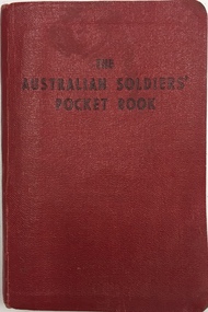
Book, Brown, Prior, Anderson Pty Ltd, The Australian Soldiers' Pocket Book : Containing useful information for Australian soldiers, 1940
... in Brougham Street and represented North Ward on Kew Council from 1952... and represented North Ward on Kew Council from 1952 to 1968. He ...Booklet produced in 1940 for members of the 2nd AIF by the Australian Comforts Fund Victorian Division. The 128-page pocket-sized book could be carried everywhere and provided Australian soldiers with a wide range of useful information about the requirements of war service and many other important details such as: The Laws and Customs of War - including Geneva Convention guidelines, notes on spies and insignia of rank; Things a Soldier should Know - including over 60 points; Signaling - including flags, morse code, shipboard bell times and time zone; Decorations Awarded to Australians in the Great War; Arabic and Japanese words; First Aid for gas injuries etc.; Australian Historical Events, facts and figures etc.; and Conduct Overseas - including expectations of behaviour when representing Australia. non-fictionaustralian comforts fund (victoria), second world war 1939-1945, hugh george ferguson -
 Kew Historical Society Inc
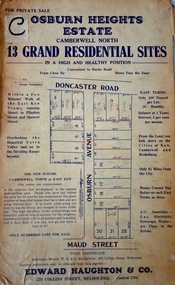
Plan - Subdivision Plan, Osburn Heights Estate, 1938
... the text: ‘The New Suburb: Camberwell North or East Kew (the names...: ‘The New Suburb: Camberwell North or East Kew (the names ...Edward Haughton & Co, in promoting the Osburn Heights Estate in what is now Balwyn North, attempted to capitalize on the subdivision’s proximity to East Kew. One section of the plan is includes the text: ‘The New Suburb: Camberwell North or East Kew (the names are synonymous)’. The Osburn Heights subdivision was part of a series of subdivisions running between Doncaster Road and Maud Street, including the ‘Pointed Firs Estate’ (MAP.0010). This subdivision included 13 ‘grand residential sites’ for sale in Doncaster Road, Maud Street and Osburn Avenue.subdivision plans - camberwell north, osburn heights estate -
 Kew Historical Society Inc
Map, MMBW, MMBW Plan No.117 Heidelberg & Kew, 1900-1910
... covers what was then the north eastern part of Kew showing... in Victoria. A number of the Kew maps have additional details added ...The Melbourne and Metropolitan Board of Works (MMBW) was established by an act of the Victorian Parliament in 1890 to prepare for and to implement a sewerage and water reticulation system across what was then inner Melbourne, its surrounding and middle distance suburbs, including Kew. The MMBW was disbanded in 1991.The map collection of the Kew Historical Society has at its core the historic maps assembled and originally stored in the City Engineer's Department of the City of Kew. These include maps in a number of scales. The vast majority of maps were produced by the MMBW in the first two decades of the twentieth century, and are solid working maps, backed by linen for durability. These maps are historically significant to Kew, the City of Boroondara and to the history of the development of state utilities in Victoria. A number of the Kew maps have additional details added by former municipal officers, including the levels reached by various floods. As these were working documents, information was added to them long after the period of their initial production and distribution.Early map of part of the Borough of Kew, created in the early twentieth century, at a scale 160 ft to 1 inch. The map covers what was then the north eastern part of Kew showing the natural landscape and limited development on the south side of the Yarra River. In the Kew section, south of the river, the land is occupied currently by the Greenacres and Kew Golf Clubs. The map shows the extent of urban development by that time and the outlines of the few built structures in the municipality. The height above sea level of all parts of the landscape are indicated numerically in feet. Contour lines and the levels of historic floods were added in ink to the map at a later stage. MELBOURNE AND METROPOLITAN BOARD OF WORKS / PLAN NO. 117 / HEIDELBERG & KEW melbourne & metropolitan board of works, mmbw maps, borough of kew, cartography, mmbw plan no. 117, kew (vic.) -- maps, heidelberg (vic.) -- maps -
 Kew Historical Society Inc
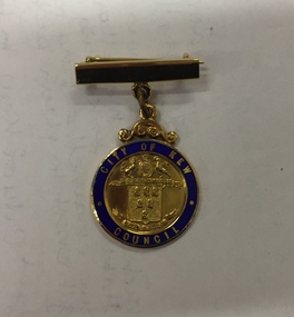
Badge - Identification Badge, Mrs HG Ferguson, Mayoress, City of Kew 1959-60, 1959
... built a home in Brougham Street and represented North Ward... in Brougham Street and represented North Ward on Kew Council from 1952 ...Hugh George Ferguson was born in June 1900 in Williamstown. After his family moved to Kew, they lived in Fernhurst Grove while his future wife’s family lived in Fellows Street. He married in 1940 and subsequently joined the Second AIF. In 1945, he was reported to be the ACF (Australian Comforts Fund) Commissioner in Borneo [Kalimantan]. After the Second World War, he worked as a Billeting Affairs Organiser for the Dutch Government, resettling migrants in Australia. He also worked in advertising as an account manager, and as campaign director for Arthur Rylah in Victorian politics. He directed the first major trade fairs at the Royal Exhibition Buildings after the Second World War, including ‘Australia Makes It Exhibition’ in 1947, the ‘Australian Industrial Fair’ in 1949 and 1950, the ‘Modern Home Exhibition’ in 1949, and ‘Made in Australia’ in 1952. The funds raised during the latter were earmarked for a ‘bankrupt’ Queen Victoria Hospital. He built a home in Brougham Street and represented North Ward on Kew Council from 1952 to 1968. He was elected Mayor in 1959. Hugh Ferguson died in 1975, aged 75. He was buried on 2 September in Grave 201, Special (Non- Denominational) Compartment A, Boroondara General Cemetery.A gold plated bar brooch with suspended medallion having a blue enamelled ring surrounding the City of Kew crest in reliefFront: City of Kew, above the city of Kew crest with Council below Rear: Mrs H. G. Ferguson, Mayoress, 1959-60city of kew, mayoresses - kew (vic), mrs hg ferguson -
 Kew Historical Society Inc
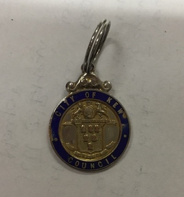
Badge - Identification Badge, Stoke, Cr HG Ferguson, City of Kew, 1955, 1955
... built a home in Brougham Street and represented North Ward... in Brougham Street and represented North Ward on Kew Council from 1952 ...Hugh George Ferguson was born in June 1900 in Williamstown. After his family moved to Kew, they lived in Fernhurst Grove while his future wife’s family lived in Fellows Street. He married in 1940 and subsequently joined the Second AIF. In 1945, he was reported to be the ACF (Australian Comforts Fund) Commissioner in Borneo [Kalimantan]. After the Second World War, he worked as a Billeting Affairs Organiser for the Dutch Government, resettling migrants in Australia. He also worked in advertising as an account manager, and as campaign director for Arthur Rylah in Victorian politics. He directed the first major trade fairs at the Royal Exhibition Buildings after the Second World War, including ‘Australia Makes It Exhibition’ in 1947, the ‘Australian Industrial Fair’ in 1949 and 1950, the ‘Modern Home Exhibition’ in 1949, and ‘Made in Australia’ in 1952. The funds raised during the latter were earmarked for a ‘bankrupt’ Queen Victoria Hospital. He built a home in Brougham Street and represented North Ward on Kew Council from 1952 to 1968. He was elected Mayor in 1959. Hugh Ferguson died in 1975, aged 75. He was buried on 2 September in Grave 201, Special (Non- Denominational) Compartment A, Boroondara General Cemetery.City of Kew identification badge issued to sitting councillors. The City of Kew cost is surrounded by a blue enamel band with City of Kew Council picked out in gold cloisonné.Front: City of Kew to top, Crest in middle with Council below Rear: Cr H. G. Ferguson 27-8-1955mayors of kew - cr hg ferguson, kew council, city of kew -
Kew Historical Society Inc
Archive (Sub-series) - Subject File, Kew Historical Society, Grip of Time, 1982
... of Time (1979) - installed on the north wall of the Kew Town Hall...) - installed on the north wall of the Kew Town Hall (now the Kew ...Various partiesReference, Research, InformationSecondary Values (KHS Imposed Order)Subject file containing both primary and secondary sources relating to the sculpture by Peter Schipperheyn (b.1955) - Grip of Time (1979) - installed on the north wall of the Kew Town Hall (now the Kew Library) in 1983. Mrs Laurel Abercrombie, a Kew resident, donated the sculpture to the City of Kew in 1982, and it formed part of the ‘municipal collection’ of the former City of Kew (now City of Boroondara). A note in the file records that prior to its installation on its current site; it was attached to a brick wall at the side of Abercrombie Galleries, Johnson Street, Collingwood. It was restored by the sculptor c.1996. The file contains two colour photographs of the sculpture and newspaper articles recording controversy at the time of its installation. The file also contains correspondence between the Society and the City of Boroondara relating to the plaque that was beside the sculpture.kew historical society - archives, kew library, kew civic hall, kew town hall, grip of time, peter schipperheyn (1955-), artworks - kew (vic), city of kew - municipal collectionkew historical society - archives, kew library, kew civic hall, kew town hall, grip of time, peter schipperheyn (1955-), artworks - kew (vic), city of kew - municipal collection -
Kew Historical Society Inc
Archive (Sub-series) - Subject File, FERGUSON, Cr Hugh George, 1959
... built a home in Brougham Street and represented North Ward... sources. kew (vic) - history kew (vic) - politics cr. h g ferguson ...Various partiesReference, Research, InformationSecondary Values (KHS Imposed Order)Hugh George Ferguson was born in June 1900 in Williamstown. He married in 1940 and subsequently joined the Australian Imperial Forces. After the war he worked as a Billeting Affairs Organiser for the Dutch Government, resettling migrants in Australia. He also worked in advertising as an account manager, and was campaign director for Arthur Rylah is Victorian politics. After the Second World War, he organised the first major trade fairs at the Royal Exhibition Buildings including a World Trade Fair. He built a home in Brougham Street and represented North Ward on Kew Council from 1952 to 1968. He was elected Mayor for the 1959-60 term. He died in 1975, aged 75, and is buried in Boroondara Cemetery. The file on Cr. Ferguson includes newspaper articles relating to development in Kew, the new Kew Town Hall, and Cr. Ferguson’s retirement. Primary sources in the file include an original invitation to the 1959 Mayoral Dinner and the guest list, Cr Ferguson’s Registration card as a Justice of the Peace (1972), and electoral material for North Ward (1955, 1968)kew (vic) - history, kew (vic) - politics, cr. h g ferguson, hugh fergusonkew (vic) - history, kew (vic) - politics, cr. h g ferguson, hugh ferguson -
 Melbourne Tram Museum
Ephemera - Timetable/s, Melbourne & Metropolitan Tramways Board (MMTB), "MMTB Tram Timetables", 1977 to 1978
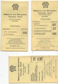
... (East Kew - Doncaster North) and 270 (East Kew - Shoppingtown... (East Kew - Doncaster North) and 270 (East Kew - Shoppingtown ...Set of 6 MMTB Tram timetables, folded sheets, 8 sections, providing timetables for specific routes, day of week giving information on tram times at specific time points, route map, sections and fares and organisation address - 616 Little Collins St. Melbourne. All printed on yellow paper. 1. - Route 67, 37 and 66 - Carnegie - City via Swanston St (67), via William St (37) and Glenhuntly Depot (66) - dated Oct. 1978. .2 - Route 69 - Kew Cotham Road - St Kilda Beach dated Dec. 1978 .3 - Route 70, 71 and 76 - Wattle Park - Batman Ave, Arraign Road (Route 71) and Camberwell Depot (Route 76), dated May 1978 .4 - Route 72, 32 and 73 - Camberwell City via Swanston St (72), via William St (32) and Camberwell Junction (73) dated Sept, 1978. .5 - Route 82 - Moonee Ponds - Footscray - Highpoint West - dated Sept. 1977 .6 - Route 88, 14, 89 and 90, 96, 95 and 97 - East Preston via Bourke St (88), via Latrobe St (14), East Preston Bell St (89) and Northcote Dundas St (90) to the city and East Brunswick (96), Exhibition (95) and North Fitzroy (Park St), dated May 1978. .7 - Routes 48, 24, 40, 41, 29, 74, 76. 28 - July 1978 .8 - ditto - Weekends, July 1978, printed on green paper. .9 - Bus routes 284 (East Kew - Doncaster North) and 270 (East Kew - Shoppingtown) - dated August 1978trams, tramways, mmtb, timetables, melbourne, fares, route 14, route 32, route 37, route 66, route 67, route 69, route 70, route 71, route 72, route 73, route 76, route 82, route 88, route 89, route 90, route 95, route 96, route 97, route 48, route 24, route 40, route 41, route 29, route 74, route 76, route 28, route 284, route 270 -
 Kew Historical Society Inc
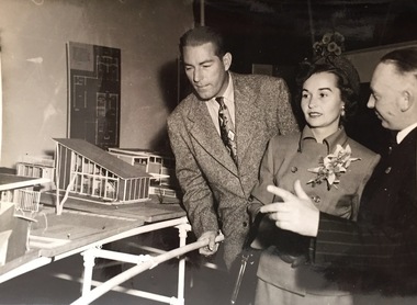
Photograph - Publicity Photograph, Herald Feature Service, Inspection of Architectural Models for a New Kew City Hall, circa 1959, 1959
... and represented North Ward on Kew Council from 1952 to 1968. He... in Brougham Street and represented North Ward on Kew Council from 1952 ...The original Kew Town Hall offices were located in Walpole Street, Kew. Before 1960, even though it had been much discussed over a number of decades, Kew did not have a 'civic hall'. When required, events such as balls, exhibitions or theatrical events were held in the Kew Recreation Hall in Walpole Street. A new City Hall was to be opened by Sir Robert Menzies in 1960. It was located beside the Alexandra Gardens in Cotham Road. It is now used as the Kew Library. Cr Hugh George Ferguson (at right) was born in June 1900 in Williamstown. After his family moved to Kew, they lived in Fernhurst Grove while his future wife’s family lived in Fellows Street. He married in 1940 and subsequently joined the Australian Imperial Forces. After the war he worked as a Billeting Affairs Organiser for the Dutch Government, resettling migrants in Australia. He also worked in advertising as an account manager, and was campaign director for Arthur Rylah is Victorian politics. He organised the first major trade fairs at the Royal Exhibition Buildings after the Second World War, including a World Trade Fair. He built a home in Brougham Street and represented North Ward on Kew Council from 1952 to 1968. He was elected Mayor for the 1959-60 term. He died in 1975, aged 75, and is buried in Boroondara Cemetery.An item of historical interest donated by members of the Dods family in 2006. The Dods-Ferguson Collection includes a number of items once in the possession of the families related to or descended from two mayors of Kew: Cr. Hugh Ferguson and Cr. Frederick Dods.Publicity photograph of two men and a woman inspecting architectural models for a new Kew City Hall. The man at the right of the photograph is Cr Hugh George Ferguson, Mayor of Kew 1959-60. The Hall, now occupied by the Kew Library, was opened by The Hon H.E. Bolte MLA, Premier of Victoria in 1960.Herald Sun Feature Service / Hugh G. Ferguson & Associates / New Kew City Hall. kew city hall, hugh g. ferguson & asociates, architectural models - kew, cr hugh george ferguson -
 Melbourne Tram Museum
Slide - Set of 23 - MMTB Tram substations and offices, Robert Green, 3/1990
... North Fitzroy 13 - Holden St North Fitzroy 14 - East Kew - High... 13 - Holden St North Fitzroy 14 - East Kew - High St. 15 ...Set of 23 colour slides of MMTB tramway substations and the Victoria St Office, by Robert Green Mar 1990. 1 - Carlton Substation - Queensberry St. 2 - Carlton Substation - Queensberry St. 3 - Coburg - Moore St 4 - Glen Huntly Depot substation 5 - Fitzroy - Young St. 6 - Fitzroy - Young St. 7 - Station St Camberwell 8 - Malvern Tram depot 9 - Brunswick Rd, Brunswick 10 - Brunswick Rd, Brunswick 11 - Brunswick Rd, Brunswick 12 - Holden St North Fitzroy 13 - Holden St North Fitzroy 14 - East Kew - High St. 15 - East Kew - High St. 16 - East Kew - High St. 17 - East Kew - High St. 18 - Little Bourke St Melbourne 19 - Former branch offices - Victoria Parade Fitzroy 20 - Former branch offices - Victoria Parade Fitzroy 21 - Former branch offices - Victoria Parade Fitzroy 22 - Former branch offices - Victoria Parade Fitzroy - 2004 23 - Former branch offices - Victoria Parade Fitzroy = 2004Yields information about Melbourne tramway substationsSet of 23 Kodak colour slides in plastic mounts.All slides have their location marked on them in black ink.tramways, mmtb, substations, carlton, queensberry st, coburg, glen huntly, north fitzroy, young st, camberwell, malvern depot, brunswick road, brunswick, holden st, east kew, little bourke st, branch offices, victoria parade -
Box Hill Historical Society
Photograph - Debutantes, 1966
... Hill and St. Clare's Box Hill North, was held at Kew City Hall... Hill and St. Clare's Box Hill North, was held at Kew City Hall ...Group of debutantes with Mrs. Marie Dewar (Box Hill Lady Mayoress) at St. Francis Xavier Debutante Ball, Kew Town Hall in 1966. The 1966 annual Parish Ball of St. Francis Xavier's Box Hill and St. Clare's Box Hill North, was held at Kew City Hall. Host Mr. R. Daffy, O.B.E. and Mrs Daffy welcomed more than 400 guests. Official guests to the ball included Rev. Fr. Conquest, P.P., and Rev. Fr. Deakin, of St Francis Xavier's, Rev. Fr. Kelly and Rev. Fr. Martin of St Clare's, Rev. Brs. Doolan, Principal and Rev. Br. Faulkner of St. Leo's College, Box Hill. Mrs. H. Hancock, chaperone, presented the ten debutantes to the Mayor and Mayoress of Box Hill, Cr. and Mrs. S. Dewar. Debutantes were: Anne Lawrence, Mary Fisher, Gabrielle Long, Tricia Coffey, Annette Wilkinson, Annette Stagg, Cathy Wernert, Christine Timms, Susan Hynes and Beverley Sullivan. The debutantes were trained by Mr. A. Curtis. Mr. Arthur Lakeman was compere and the music provided by Ron Richards Dance Band.B&w photo mounted in cream cardboard folderdebutantes, st francis xavier, 1966, dewar> marie, mayoress, st clare's catholic church, ron richards dance band, richards> ron -
Box Hill Historical Society
Photograph - Debutantes, 1966
... Xavier's Box Hill and St. Clare's Box Hill North, was held at Kew... Xavier's Box Hill and St. Clare's Box Hill North, was held at Kew ...Group of debutantes with partners and Mr. Stan Dewar and Mrs. Marie Dewar (on his right) at St. Francis Xavier Debutante Ball, Kew Town Hall in 1966. The lady on his left is chaperone Mary Hancock. The 1966 annual Parish Ball of St. Francis Xavier's Box Hill and St. Clare's Box Hill North, was held at Kew City Hall. Host Mr. R. Daffy, O.B.E. and Mrs Daffy welcomed more than 400 guests. Official guests to the ball included Rev. Fr. Conquest, P.P., and Rev. Fr. Deakin, of St Francis Xavier's, Rev. Fr. Kelly and Rev. Fr. Martin of St Clare's, Rev. Brs. Doolan, Principal and Rev. Br. Faulkner of St. Leo's College, Box Hill. Mrs. H. Hancock, chaperone, presented the ten debutantes to the Mayor and Mayoress of Box Hill, Cr. and Mrs. S. Dewar. Debutantes and their partners were: Anne Lawrence and John Ross, Mary Fisher and Bruce Williams, Gabrielle Long and Paul McCann, Tricia Coffey and Emiel Timmers, Annette Wilkinson and Jim Oliver, Annette Stagg and Jeff Carthew, Cathy Wernert and Norman Christopherson, Christine Timms and Alan McKay, Susan Hynes and Michael Smith, Beverley Sullivan and John Hosie. The debutantes were trained by Mr. A. Curtis. Mr. Arthur Lakeman was compere and the music provided by Ron Richards Dance Band.B&w photo mounted in cream cardboard folderdebutantes, st francis xavier, 1966, dewar> marie, ron richards dance band, richards> ron, dewar> stan, hancock> mary, st. clare's catholic church -
 The Beechworth Burke Museum
Postcard, C. F. Falk, c.1930
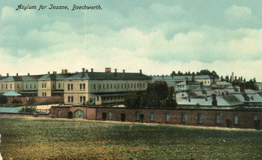
This postcard contains a depiction of the Mayday Hills Hospital in Beechworth, Victoria from the direction of Farm Hill, circa 1930. It was designed by C.F.Falk in Beechworth and printed in Saxony which is a landlocked state of Germany which borders the states of Brandenburg, Saxony-Anhalt, Thuringia, Bavaria and the countries of Poland and the Czech Republic. The depiction is a painting of the Mayday Hill Hospital which portrays the extensive buildings an HaHa wall (many of which have not survived to the present day). It provides a unique opportunity to reconstruct this historical site as it may have looked in approximately 1930. Beechworth's Mayday Hills was chosen as the site of Victoria's newest asylum, at the time, due to the landscape and altitude. The hilltop atmosphere and the native fauna, it was argued, would assist in the cure of the patients kept at the hospital (Wood 1985, 122). The positioning of the hospital had a beneficial effect on the rural town. A pamphlet published by James Ingram and Son (1849) reveal that famous landmarks in Beechworth which included the Post Office, Gaol, Courthouse and Asylum "demonstrate the appreciation of Beechworth by the Government not only as as important district center, but also as a site unrivaled as a sanitarium". There were other locations in contention at the time, but ultimately Beechworth was chosen (Craig 2000, 33). The extent of buildings displayed in this postcard helps convey the imposing and enormity of the structure before decommission. Prior to the creation of the Asylum in Beechworth, those charged with having mental illnesses or, as it was termed, "insanity" were unable to be properly cared for in the Gaol (which is where they were often sent). John Buckley Castieau wrote, in 1861 for the Ovens and Murray Advertiser, that the Gaol was unable to properly care for those classified then as "insane" but that they would endeavor to treat them above the other inmates (which he notes is not always the case in other establishments). Castieau wrote this in favour of supporting the building of the Mayday Hills Hospital in Beechworth. It was stated that at the time the Mayday Hills Hospital was built, there were 83 prisoners kept in the Gaol who were to be rehoused to the Hospital on the grounds of "insanity". The classification as someone as "insane", in this period of time is a reflection on the inability to cure and understand illnesses of the mind during the mid to late 1800s. The title on the obverse of this photograph as "Asylum for Insane, Beechworth" reflects a bygone era and attitude to mental health. Beechworth's Mayday Hills was chosen as the site of Victoria's newest asylum, at the time, due to the landscape and altitude. Opening on the 24th of October 1867, the Mayday Hills Hospital was originally named the "Ovens Lunatic Asylum", a title which is very much a product of its time. Whilst controversial, changes to the name is part of the history of the Hospital and can provide much insight into the understanding of mental illness throughout history and the use/disuse of this term provides information into the reception/changing opinions of mental illness in society. The Hospital would later become known as the "Mayday Hills Asylum" and/or "Mayday Hills Hospital" with the latter being the most commonly used title. An article in the Ovens and Murray Advertiser notes that on the 7th of March 1865, the foundation stone of the Hospital was laid (it would officially open in 1867) and that it was such a moment of accomplishment and joy for Beechworth that a letter to the editor even suggested that there should be a holiday dedicated to the day the foundation stone as laid. This reveals an extent to which the townspeople of early Beechworth valued the construction of the Hospital in their town. It provided the town with a sense of prestige and honour.At first glance, the remains of the Mayday Hills Hospital in Beechworth, Victoria, inspire tragedy, trauma and beauty. The buildings themselves, with their Italianate style Renaissance architecture designed by J.J. Clark (Craig 2000, 49 & Smith 2016, 203) reflect a bygone period of European and Australian history. The gardens provide a sense of tranquility and beauty. The experience of those within these walls remains a valuable area of study to provide a more complete understanding. This particular hospital is considered the fourth of its like and one of three identified as the largest of their kind. The Mayday Hills Hospital is a sister to the Kew and Ararat Asylums in Melbourne which are both located in relative proximity. Understanding the role of the Mayday Hills Hospital in Beechworth history is integral to understanding the development of the goldfields town, but also for providing important information as to the history of caring for, and the reception of, mental illnesses in Australian and wider European history. Mayday Hills provides a case study which can be researched through oral history, an analysis of the grounds/buildings and through images like this postcard which portray the structure in a highly deliberate manner. Images like this depict the strong façade of the Hospital and provide a glimpse into the tranquility of the gardens. This has been done deliberately to provide a sense of comfort and healing about the building to those looking from the outside. Further research into the importance of the Hospital in Beechworth and it's connection to the town will be supported through images like these kept in the Mayday Hills photo album in the collection of the Burke Museum.Colour rectangular postcard printed on cardObverse: Asylum for Insane, Beechworth. / Reverse: C.F. Faulk, Beechworth. Printed in Saxony. POST CARD / ADDRESS ONLY / AFFIX / STAMP / B 2298 / 1997.2457 /mental hospital, insane asylum, mayday hills mental hospital, beechworth, mayday hills, asylum, gold town, north-east victoria, ararat asylum, kew asylum -
 Ringwood and District Historical Society
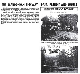
Print - VicRoads publication supplement, The Maroondah Highway - Past, Present and Future - 1997
Copy of 4-page report with handwritten covering facsimile transmission sheet from Michael Comerford, VicRoads Library & Business Information Centre, Kew, Victoria. +Additional Keywords: Marie Mitchell