Showing 6750 items
matching rivers
-
 Mrs Aeneas Gunn Memorial Library
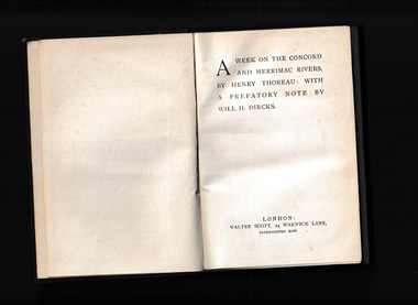
Book, Walter Scott, A week on the Concord and Merrimac Rivers, 1880
... A week on the Concord and Merrimac Rivers ...A trip on several rivers in the United Statesp.349.non-fictionA trip on several rivers in the United Statesconcord river - description and travel, merrimac river - descripotion and travel -
 Wodonga & District Historical Society Inc
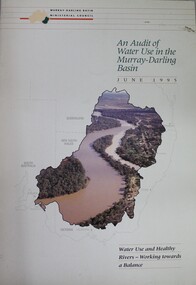
Book - Audit of Water Use in the Murray-Darling Basin. Water use and healthy rivers - working towards a balance, Murray-Darling Basin Ministerial Council, 1995
... and healthy rivers - working towards a balance ...This paper describes the water audit which has been carried out in the Murray-Darling Basin. It highlights that diversions have increased significantly since 1988 and will continue to increase unless water management arrangements are amended. This increase in diversion will have an adverse impact on river health. It concludes that the most urgent priority is to define the appropriate balance between water for consumptive uses (i.e. irrigation, domestic and industrial) and that required to be left in rivers (environmental flows) to ensure that the consumptive uses are sustainable and that the rivers remain in a healthy state. This water audit does not attempt to strike the balance between consumptive and instream water use. Rather it provides a sound body of knowledge on which to base the necessary community discussions which will lead to decisions about an appropriate balance between consumptive and instream uses.non-fictionThis paper describes the water audit which has been carried out in the Murray-Darling Basin. It highlights that diversions have increased significantly since 1988 and will continue to increase unless water management arrangements are amended. This increase in diversion will have an adverse impact on river health. It concludes that the most urgent priority is to define the appropriate balance between water for consumptive uses (i.e. irrigation, domestic and industrial) and that required to be left in rivers (environmental flows) to ensure that the consumptive uses are sustainable and that the rivers remain in a healthy state. This water audit does not attempt to strike the balance between consumptive and instream water use. Rather it provides a sound body of knowledge on which to base the necessary community discussions which will lead to decisions about an appropriate balance between consumptive and instream uses.murray-darling basin, water management, water audit murray-darling -
 Wodonga & District Historical Society Inc
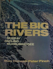
Book - The Big Rivers: Murray Darling Murrumbidgee, Max Colwell, 1978
... The Big Rivers: Murray Darling Murrumbidgee ...A geography, description and travel guide to the "Big Rivers" of the Murray- Darling basin, including many photos of the region.non-fictionA geography, description and travel guide to the "Big Rivers" of the Murray- Darling basin, including many photos of the region.murray river (n.s.w.-s.a.), murray river valley, darling river, murrumbidgee river, description and travel nsw, description and travel south australia -
 Wodonga & District Historical Society Inc
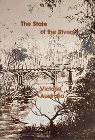
Book - The State of the Rivers, Victoria Australia, Constable, D & Smith, K, 1983
... The State of the Rivers, Victoria Australia ...Rivers play an essential part in the life and wealth of our society. They are also the most striking feature of the landscape, contributing much to the beauty of rural and urban surroundings as well as to the recreation, peace and happiness of our people. This report includes historical colour and black and white photos and maps. It aimed to give an accurate account of the condition of the rivers of Victoria. It was produced by the Standing Consultative Committee on River Improvement.A 64 page volume including text, black and white and colour images and maps.Rivers play an essential part in the life and wealth of our society. They are also the most striking feature of the landscape, contributing much to the beauty of rural and urban surroundings as well as to the recreation, peace and happiness of our people. This report includes historical colour and black and white photos and maps. It aimed to give an accurate account of the condition of the rivers of Victoria. It was produced by the Standing Consultative Committee on River Improvement.rivers in victoria, conservation victoria, water supply victoria -
 Clunes Museum
Pamphlet, BUSINESS & TOURISM, BURIED RIVERS OF GOLD, 2021
... BURIED RIVERS OF GOLD ...MAP OF DEEP LEAD MINES, CRESWICK. WALKING TOURCOLOURED PAMPHLET FOLDED TO DL SIZE. INCLUDES MAP AND INFORMATION FOR SELF GUIDED TOUR. MAP OF THE DEEP LEAD MINES, CRESWICK, AND NOTES FOR YOUR SELF-GUIDED TOUR.gold mining, creswick -
 Wyndham Art Gallery (Wyndham City Council)
Artwork, other, Jody Haines, DIGITAL PORTRAIT: Rivers, Aliza, 2018
... DIGITAL PORTRAIT: Rivers, Aliza ...This work was created during a program called Flipping the Script, funded via Wyndham City Council and Creative Victoria, August - September 2018. The project was aimed at young women from the African diaspora, to provide an opportunity to learn methods of digital and visual storytelling.african diaspora, portrait, photography, digital, australian first nations art, first nations photography -
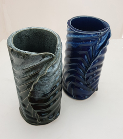 Federation University Art Collection
Ceramic, Jan Alexander, 'Rivers' by Jan Alexander, 2022
... 'Rivers' by Jan Alexander ...Jan ALEXANDER Jan Alexander completed a Graduate Diploma of Ceramics at Federation University from 2019-2022. In her work Jan explores the synergy of form, texture, and glaze, and the crafting patterns of movement and reflective surfaces that capture and interact with light, to create an ambience which invites contemplation, to instil a tranquil tone.ceramics, jan alexander, dvc art award -
Merbein District Historical Society
Map, State Rivers & Water Supply Commission-Merbein Urban District n.d, unknown
... State Rivers & Water Supply Commission-Merbein Urban ...state rivers and water supply commission, merbein township -
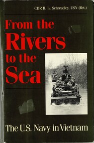 National Vietnam Veterans Museum (NVVM)
Book, Schreadley, R. L. CDR, From the Rivers to the Sea: The U.S.Navy in Vietnam, 1992
... From the Rivers to the Sea: The U.S.Navy in Vietnam. ...Although many books on the Veitnam War have been published, until now thre has not been a comphresensive, one-volume history of the U.S. Navy's roles in that conflict.Although many books on the Veitnam War have been published, until now thre has not been a comphresensive, one-volume history of the U.S. Navy's roles in that conflict.united states. navy -- history -- vietnam war, united states. navy -- history -- vietnamese conflict, vietnam war, 1961-1975 -- naval operations, american., u.s. navy, viet cong, mekong delta, tonkin gulf, south vietnamese navy -
Lakes Entrance Historical Society
Booklet, Ronald Parsons, Shipowners Trading to Northern Rivers of New South Wales, 2003 June
... Shipowners Trading to Northern Rivers of New South Wales ...Shipping services to Northern Rivers of N.S. W.Small booklet 101 pagesnon-fictionShipping services to Northern Rivers of N.S. W.shipping, trade, maritime history -
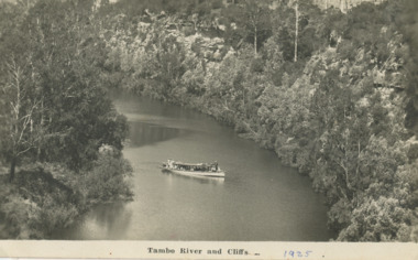 Lakes Entrance Historical Society
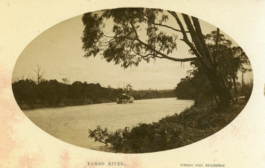
Postcard, W S Vogt Bairnsdale, Tambo River Swan Reach Victoria, 1925 c
... Rivers ...Note with photograph says This is a view of the Tambo River about a mile and a half up from where I am staying. The river here is narrow owing to cliffs with love from Arthur. Maybe Archie MacArthers boat GowrieSepia toned postcard of a passenger launch on the Tambo River below the cliffs upstream from Swan Reach Victoriaboats and boating, rivers, tourism -
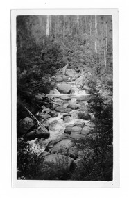 Marysville & District Historical Society
Photograph (item) - Black and white photograph, Mabel Russell Sutherland, December 1935
A black and white photograph of the Taggerty River near Marysville in Victoria.A black and white photograph of the Taggerty River near Marysville in Victoria.SUTHERLAND/ STUDIO/ HEALESVILLE Taggerty River/ Dec. 1935 19taggerty river, marysville, victoria, photograph, mabel russell sutherland, sutherland studio -
 Lakes Entrance Historical Society
Postcard - Gasson/Brodribb, Bulmer, 1915 - 1920 c
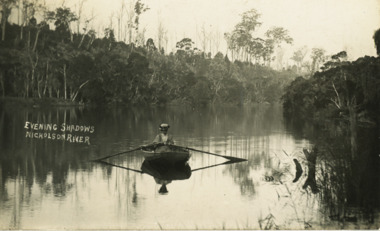
Also a second postcard showing Sylvia Gasson later Wigg in rowing boat on Nicholson River 05494.1 13.5 x 9 cmBlack and white postcard showing Sylvia Gasson nee Brodribb seated in a rowing boat on Nicholson River showing high bank opposite with dead trees on top Nicholson VictoriaEvening Shadowsw Nicholson Rivergenealogy, boats and boating -
 Orbost & District Historical Society
black and white photographs, C1970
These photographs are of the 1922 road bridge across the Snowy River at Orbost. This bridge over the Snowy River was opened on July 4 1922. It was constructed in 1922 alongside the previous suspension bridge. Its building was a combined effort of the Victorian Railways and the Country Roads Board at a cost of 35,000 pounds. It was replaced in 1976 by the present bridge after several major floods.This bridge was replaced in 1976 after several major floods. These photographs are pictorial records of the 1922 brige.Two small black / white photographs of a road bridge across a river. 3248.1 is a close-up of wooden pylons.on label on back - "Snowy River Bridge at Orbost 1922 Bridge"bridge-orbost snowy-river-bridge -
 Melbourne Legacy
Photograph, Junior Legatee Camp 1987, 1987
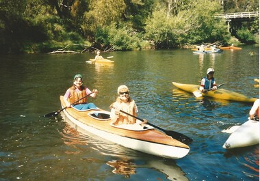
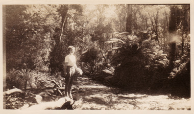
Photographs of Junior Legatees kayaking on the McAllister River in Licola. Melbourne Legacy arranged many events for Junior Legatees to experience. Including an annual two week camp, usually in January. The venue varied over the years. It was with a group of photos from the 1990's in a folio with paper labels. It is possible these photos are from two different dates. The one that is labelled as Licola 1987 is on different photographic paper to the other four photos.A record of events run for Junior Legatees by Melbourne Legacy.Colour photo x 5 of kayaking on McAllister River in 1987.Handwritten on reverse of 01843.1 '1987 McAllister River Licola'junior legatee outing, camp, kayaking -
 Kew Historical Society Inc
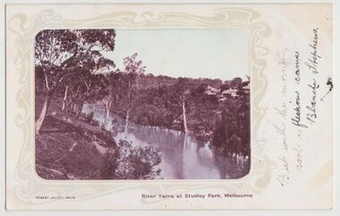
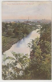
Postcard, River Yarra at Studley Park, Melbourne, 1900-04
Monochrome postcard titled lower right: “RIVER YARRA AT STUDLEY PARK, MELBOURNE”. The postcard was produced by ROBERT JOLLEY, MELB, (active 1900-1904). The photo is positioned to the left of the card and framed by an art nouveau design. A handwritten annotation on the front reads “BUT WITH THE MORNING / COOL REFLECTION CAME / BLANCHE STEPHENS”. On the reverse, there is a handwritten address in black ink to: MISS L STEPHENS / 26 WEST TERRACE / ADELAIDE. There is no division on the reverse of the postcard, dating it to before 1905. It lacks a postage stamp and postmark. Monochrome postcard of the River Yarra in Studley Park. The view is of the Yarra and its banks, with Kew on the left and Abbotsford on the right, as it appeared in the years 1900-1904. On the Abbotsford side of the river, there are a number of weeping willows lining the banks and houses on the hillside. The Studley Park side of the river includes some remnant vegetation and meandering walking tracks. Three very small figures are sitting on the Kew side. "RIVER YARRA AT STUDLEY PARK, MELBOURNE"river yarra -- kew (vic.), postcards -- kew, postcards -- studley park, robert jolley -
 Beechworth Honey Archive
Publication, A consumer's dictionary of cosmetic ingredients (Winter, R.), New York, 2005, 2005
... New York, Three Rivers Press ... -
 Kew Historical Society Inc
Postcard, River Yarra at Studley Park, Kew, c.1908
Colour-tinted postcard, titled in red upper left: “RIVER YARRA AT STUDLEY PARK, KEW”. On the divided reverse, the card is addressed to “MISS JOLLEY / MELB. TRAM & O[MNIBUS]. CO / BOURKE STREET, MELB”. The sender has dated the card 21.12.08. In the upper right corner, there is a pink Victorian one penny postage stamp; sent from Melbourne on 22DE 08. (The division of the reverse of the postcard, allowing a message to be written on one half and the address on the other, was not permitted in Australia until 1905.) The manufacturer of the postcard is indicated by the initials “W.T.P”, printed in a green floral diamond, printed centre top. This was the trademark of WT Pater, printers & stationers. William Thompson Pater was born in Melbourne in 1861. His business at 271 Little Collins Street offered Christmas cards, booklets, calendars, and leather goods as well as postcards and albums.Hand-tinted postcard of the River Yarra in Studley Park, Kew. The birds-eye view is of a bridge on the Yarra (Johnston Street?) linking Kew and Abbotsford as it appeared in c.1908. On the Abbotsford side of the river, fields lead down to the river, with some remnant trees. The Kew side of the river, in contrast, due to its steep banks, retains its original vegetation. In the distance is industrial development, in what might be Fairfield and Alphington.“RIVER YARRA AT STUDLEY PARK, KEW”river yarra -- kew (vic.), william thompson pater, w.t.p., postcards -- kew, postcards -- studley park, bridges - yarra river -- kew (vic.) -
 Warrnambool and District Historical Society Inc.
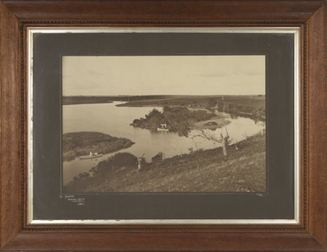
Photograph - Framed Photograph of the Islands in the Hopkins River, Jordan Studios, Warrnambool, 1911
This photograph shows the islands in the Hopkins River in 1911. This section of the river is in the Allansford area, near Jubilee Park (Hopkins River Caravan Park). It was, and still is, a picnic and fishing spot. On one of the islands is an unmarked grave which may be that of Jemima Christine Allan, the first wife of one of the first European settlers in the Allansford area, William Allan. She died in 1842. The photograph was taken by Jordan Studios so the photographer may be either Joseph Jordan, one of the best-known Warrnambool photographers of the past, or his son Arthur, also a well-credentialled photographer.This photograph is considerable historical importance, showing a section of the Hopkins River in the Warrnambool region in 1911.This is a black and white photograph in a wooden frame with a patterned edging. The photograph is inset with a gilt metal edging and enclosed in glass. The backing is wooden with a wire cord for hanging. The photograph shows the river with islands covered in vegetation. On the river are two boats, one wuih four occupants standing up in the boat and the other with two occupants. In the ccntre of the photograph is a tree stump and a dead tree.The Islands Hopkins River Warrnambool 1911 Jordan Photohopkins river, jemima allan, jordan studios -
 Orbost & District Historical Society
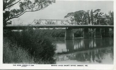
black and white photograph, Rose Stereograph Company, first half 20th century
A new bridge over the Snowy River at Orbost was opened for traffic on June 20th 1922. It was a new timber and steel girder structure, a joint Country Roads Board — Victorian Railways venture and was built and completed at a cost of £41,000 (the steel girders came from the Flinders Street viaduct reconstruction). Subsequently it was decided not to take the railway across the river, and the bridge was only ever used by road traffic. Postcards form a vital part of social and historical records for researchers. This postcard is a pictorial record of an earlier bridge across the Snowy River at Orbost.A black / white postcard photograph of a bridge over the Snowy River at Orbost.0n front - The Rose Series P1200 copyright Bridge Over Snowy River Orbost Vic.snowy-river-bridge -
 Lakes Entrance Historical Society
Photograph - P.S. Tanjil, Vogt. W S, 1915 c
Black and white photograph showing P S Tanjil on Tambo River. Water level high in river, note bushes in water. Eucalypt hanging over the river on right. Thick vegetation on banks. Swan Reach VictoriaTambo Riverships and shipping, waterways -
 Port Fairy Historical Society Museum and Archives
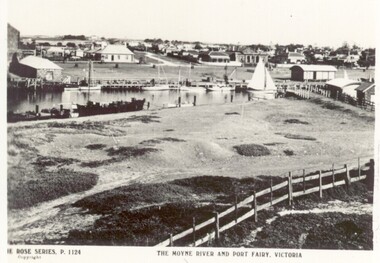
Postcard, The Rose Series / The Rose Stereographs, The Moyne River and Port Fairy, Victoria
River scene of the wharf and the buildings lining the street behind. Black and white photograph taken from Battery Hill looking across Moyne river at Merrijig Inn, Customs House and Courthouse The Rose Series P.1142 copyright- The Moyne River and Port Fairy Victoriastreet, town, moyne, river, couta boat, courthouse, merrijig -
 Lakes Entrance Historical Society
Photograph - Terraced gardens and sign for boats for let on Mitchell River near Bairnsdale Victoria, 1910 c
... Rivers ...Sign on river bank 'Boats to Let'Black and white photograph of substancial dwelling terraced gardens and out buildings on riverside, sign indicating boats for hire and five rowing boats on Mitchell River near Bairnsdale Victoriahouses, land settlement, rivers -
 Orbost & District Historical Society
black and white photograph, late 19th century
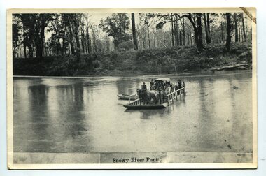
A punt crossed the Snowy River at Orbost from 1884. A bridge was constructed in 1893, but was soon damaged by a huge flood. Flooding was a regular occurrence, the worst inundations being in 1870, 1893, 1925, 1934, 1952 and 1971. Over the years major flood protection works have been implemented. The Princes Highway, which passes Orbost, now crosses the flood plain on raised concrete supports. (info, from Victorian Places Orbost)This item is associated with the Snowy River and its history. It is a pictorial record of transport in the late 19th century.A black / white photograph (copy) of a punt loaded with people and a horse-drawn carriage making its way across a river.on front at bottom - "Snowy River Punt"snowy-river-orbost transport shipping -
 Kew Historical Society Inc
Painting, Herbert J Woodhouse, River Yarra Near Dights Falls, c.1892
Herbert James Woodhouse (1854-1937) was born in Essex and arrived in Australia with his family in 1857. A painter-lithographer like his father and three of his brothers, he was a prizewinner in the South Australian Society of Arts exhibition of 1885. He also received commendations in exhibitions at the Victorian Academy of Arts and the New South Wales Arts Society. At an exhibition of his paintings at Scott’s Hotel in Collins Street in 1892, the reviewer for Table Talk noted that the ‘artist paints almost solely in the open air, and his studies are generally carried out during the trips of the Victorian Sketching Club’. One of the paintings singled out for praise was: ‘A very effective river scene at Willsmere, aptly named A Midstream Mirror, ... a picture powerful in its effective reflection of sunlight in the river.’ Herbert Woodhouse died in Geelong in June 1937, aged 82, and was buried in the Eastern Cemetery. A number of his sketchbooks are held in the collection of the State Library of Victoria.Framed oil painting on board of the River Yarra at Studley Park, Kew, by Herbert James Woodhouse (1858-1937). The artist has framed the narrow painting with trees in the foreground and a view of the Yarra River and rolling hills in the background. Verso, written by artist: "River Yarra Near Dights Falls"australian art - 19th century, herbert james woodhouse (1854-1937), yarra river - studley park -
 Marysville & District Historical Society
Photograph (item) - Black and white photograph, Approximately 1944
A black and white photograph taken at the Taggerty River near Marysville. The photograph was taken in about 1944 during a stay at Roseleigh guest house in Marysville.A black and white photograph taken at the Taggerty River near Marysville. The photograph was taken in about 1944 during a stay at Roseleigh guest house in Marysville.Marysville - Taggerty River/ about 1944/ Nancy Duncan 07marysville, victoria, australia, roseleigh guest house, grieve family, thomas charles grieve, john arthur grieve, rose grieve, ackerman family, mary moyne, elise ackerman, ken mcleod, george peters, rose emily pullum, beltana, rose lillian smith, ivy may grieve, alexander james ficinus, raymond charles smith, accommodation, photograph, nancy duncan, taggerty river -
University of Melbourne, Burnley Campus Archives
Photograph - Sepia Print, 4. View of River Through Fence
Yarra River.Labelled, " View of River through fence."yarra river, mrs. jessep, alexander william jessep, principal, a.w. jessep -
 Warrnambool and District Historical Society Inc.
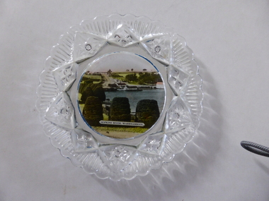
Platter, Transfer Hopkins River
This is a souvenir dish or small plate with an illustration of the Hopkins River in Warrnambool. Included in the illustration are the rowing shed, the boathouses and the lambertiana trees in the property of Lyndoch. The souvenir dish would have been sold to tourists visiting Warrnambool or Warrnambool residents in the 1920s and 30s. This type of souvenir was popular at the time in any tourist town or place in Australia. Tourism has been an important industry in Warrnambool since the late 19th century. This item is of interest as an example of the type of souvenir produced for tourists in the 1920s and 30s. It was both a useful and decorative item. It will be useful for display. This is a small glass souvenir dish. The centre of the dish features a colour illustration of the Hopkins River, Warrnambool (near its mouth). The glass around the illustration is heavily patterned and embossed. The bottom of the dish is dark blue. ‘Hopkins River Warrnambool’ tourism in warrnambool, warrnambool history -
 Orbost & District Historical Society
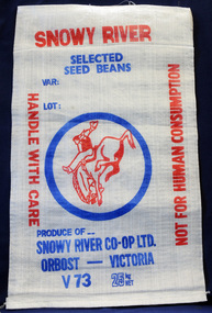
seed bag, mid 20th century
This unused bag would have been used by the snowy River Co-Op in Orbost during the 1960's-1970's to pack selected seed beans.Snowy River Seeds started life as a farmers' co-operative (Snowy River Co-op) in 1967. This item is significant because it was specially made for the seed bean industry which was a major industry in the Orbost district for over a century. A bag made of white woven synthetic material. It is unused. On the front is the logo for the Snowy River Co-Op Ltd - the 'man from Snowy River" in red print inside a blue circle. Other print is red and blue.On front: Produce of... Snowy River Co-Op Ltd Orbost - Victoria V73 25 kg NET snowy-river-co-op seed-bag -
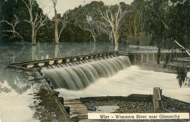 Stawell Historical Society Inc
Postcard, Wimmera River Weir at Glenorchy -- Postcard
Wimmera River Weir Glenorchy with letter written on card and 1d stamp.Coloured post card of a weir along a flooded river. Wier-Wimmera River near Glenorchy addressed to Mrs. G. Wood Hill View Stawell. Message from Oliver dated 8/6/10 plus stamp.water