Showing 152 items matching "additional land"
-
 Kew Historical Society Inc
Plan, Melbourne & Metropolitan Board of Works : Borough of Kew : Detail Plan No.1571, 1904
... of the 20th century as well as additional information about land ...The Melbourne and Metropolitan Board of Works (MMBW) plans were produced from the 1890s to the 1950s. They were crucial to the design and development of Melbourne's sewerage and drainage system. The plans, at a scale of 40 feet to 1 inch (1:480), provide a detailed historical record of Melbourne streetscapes and environmental features. Each plan covers one or two street blocks (roughly six streets), showing details of buildings, including garden layouts and ownership boundaries, and features such as laneways, drains, bridges, parks, municipal boundaries and other prominent landmarks as they existed at the time each plan was produced. (Source: State Library of Victoria)This plan forms part of a large group of MMBW plans and maps that was donated to the Society by the Mr Poulter, City Engineer of the City of Kew in 1989. Within this collection, thirty-five hand-coloured plans, backed with linen, are of statewide significance as they include annotations that provide details of construction materials used in buildings in the first decade of the 20th century as well as additional information about land ownership and usage. The copies in the Public Record Office Victoria and the State Library of Victoria are monochrome versions which do not denote building materials so that the maps in this collection are invaluable and unique tools for researchers and heritage consultants. A number of the plans are not held in the collection of the State Library of Victoria so they have the additional attribute of rarity.Original survey plan, issued by the MMBW to a contractor with responsibility for constructing sewers in the area identified on the plan within the Borough of Kew. The plan was at some stage hand-coloured, possibly by the contractor, but more likely by officers working in the Engineering Department of the Borough and later Town, then City of Kew. The hand-coloured sections of buildings on the plan were used to denote masonry or brick constructions (pink), weatherboard constructions (yellow), and public buildings (grey). This plan is the other half of Plan No.1571 representing the constructions to the west of Wellington Street before and in 1903/4. This plan represents the built environment in Edgevale Road, Wellington Street, Atkins Street, Annadale Street, Mortimer Street, and Cotham Road. Whereas there are smaller allotments and more modest housing stock facing Edgevale Road, larger blocks and more substantial houses are represented facing Cotham Road.melbourne and metropolitan board of works, detail plans, mmbw 1571, cartography -
 Kew Historical Society Inc
Plan, Melbourne & Metropolitan Board of Works : Borough of Kew : Detail Plan No.1572, 1905
... of the 20th century as well as additional information about land ...The Melbourne and Metropolitan Board of Works (MMBW) plans were produced from the 1890s to the 1950s. They were crucial to the design and development of Melbourne's sewerage and drainage system. The plans, at a scale of 40 feet to 1 inch (1:480), provide a detailed historical record of Melbourne streetscapes and environmental features. Each plan covers one or two street blocks (roughly six streets), showing details of buildings, including garden layouts and ownership boundaries, and features such as laneways, drains, bridges, parks, municipal boundaries and other prominent landmarks as they existed at the time each plan was produced. (Source: State Library of Victoria)This plan forms part of a large group of MMBW plans and maps that was donated to the Society by the Mr Poulter, City Engineer of the City of Kew in 1989. Within this collection, thirty-five hand-coloured plans, backed with linen, are of statewide significance as they include annotations that provide details of construction materials used in buildings in the first decade of the 20th century as well as additional information about land ownership and usage. The copies in the Public Record Office Victoria and the State Library of Victoria are monochrome versions which do not denote building materials so that the maps in this collection are invaluable and unique tools for researchers and heritage consultants. A number of the plans are not held in the collection of the State Library of Victoria so they have the additional attribute of rarity.Original survey plan, issued by the MMBW to a contractor with responsibility for constructing sewers in the area identified on the plan within the Borough of Kew. The plan was at some stage hand-coloured, possibly by the contractor, but more likely by officers working in the Engineering Department of the Borough and later Town, then City of Kew. The hand-coloured sections of buildings on the plan were used to denote masonry or brick constructions (pink), weatherboard constructions (yellow), and public buildings (grey). Plan No. 1572 represents the built environment bordered by Barkers Road, Wrixon Street, Edgevale Road and Fitzwilliam Street. Other streets identified on the plan include Stansell Street. Plan 1572 shows that by 1903-05, there was only patchy development in this area of Kew, mainly on Edgevale Road and Fitzwilliam Street. Only two named houses are identified: the quaintly named ‘Tweed Cottage’, and ‘Mendip’. The earliest reference to Treed Cottage in Australian newspapers is to the death of Walter Thompson, aged 74 who was a resident there in 1885. His youngest daughter was to die there in 1908. Mendip to the north of Tweed Cottage was owned by Henry Thompson; he was to die in 1901; his wife in 1932. At this period of time, Malin Street and Clivedon Court did not extend to Barkers Road.melbourne and metropolitan board of works, detail plans, mmbw 1572, cartography -
 Kew Historical Society Inc
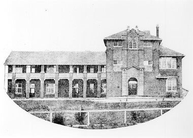
Plan, Melbourne & Metropolitan Board of Works : Borough of Kew : Detail Plan No.1573, 1905
... of the 20th century as well as additional information about land ...The Melbourne and Metropolitan Board of Works (MMBW) plans were produced from the 1890s to the 1950s. They were crucial to the design and development of Melbourne's sewerage and drainage system. The plans, at a scale of 40 feet to 1 inch (1:480), provide a detailed historical record of Melbourne streetscapes and environmental features. Each plan covers one or two street blocks (roughly six streets), showing details of buildings, including garden layouts and ownership boundaries, and features such as laneways, drains, bridges, parks, municipal boundaries and other prominent landmarks as they existed at the time each plan was produced. (Source: State Library of Victoria)This plan forms part of a large group of MMBW plans and maps that was donated to the Society by the Mr Poulter, City Engineer of the City of Kew in 1989. Within this collection, thirty-five hand-coloured plans, backed with linen, are of statewide significance as they include annotations that provide details of construction materials used in buildings in the first decade of the 20th century as well as additional information about land ownership and usage. The copies in the Public Record Office Victoria and the State Library of Victoria are monochrome versions which do not denote building materials so that the maps in this collection are invaluable and unique tools for researchers and heritage consultants. A number of the plans are not held in the collection of the State Library of Victoria so they have the additional attribute of rarity.Original survey plan, issued by the MMBW to a contractor with responsibility for constructing sewers in the area identified on the plan within the Borough of Kew. The plan was at some stage hand-coloured, possibly by the contractor, but more likely by officers working in the Engineering Department of the Borough and later Town, then City of Kew. The hand-coloured sections of buildings on the plan were used to denote masonry or brick constructions (pink), weatherboard constructions (yellow), and public buildings (grey). This plan has detailed annotations written in red or blue ink, showing prices, which may be the annual valuations of the properties, and some owners’ names, a most unusual feature on contractor's maps. Some areas, such as the buildings of Methodist Ladies’ College (MLC), include the school’s tennis court and swimming pool, but are not coloured to show building materials – did the draftsman just run out of time, or ink, or enthusiasm, before his plan had to be submitted? MLC had been founded in 1882 as a ‘modern school of the first order’ with buildings that formed ‘a collegiate institution for girls unsurpassed in the colonies’. The goal of its founders was to provide a high-class Christian education for girls, comparable with that provided elsewhere for boys. Some shops are shown along Edgevale Road, though they are not designated as commercial premises. Larger houses are depicted, including ‘Fairlawn’ in Barkers Road, and ‘Clevedon’ and ‘Rosehill’ (now demolished) in Fitzwilliam Street.melbourne and metropolitan board of works, detail plans, mmbw 1573, maps - borough of kew, cartography -
 Kew Historical Society Inc
Plan, Melbourne & Metropolitan Board of Works : Borough of Kew : Detail Plan No.1574, 1905
... of the 20th century as well as additional information about land ...The Melbourne and Metropolitan Board of Works (MMBW) plans were produced from the 1890s to the 1950s. They were crucial to the design and development of Melbourne's sewerage and drainage system. The plans, at a scale of 40 feet to 1 inch (1:480), provide a detailed historical record of Melbourne streetscapes and environmental features. Each plan covers one or two street blocks (roughly six streets), showing details of buildings, including garden layouts and ownership boundaries, and features such as laneways, drains, bridges, parks, municipal boundaries and other prominent landmarks as they existed at the time each plan was produced. (Source: State Library of Victoria)This plan forms part of a large group of MMBW plans and maps that was donated to the Society by the Mr Poulter, City Engineer of the City of Kew in 1989. Within this collection, thirty-five hand-coloured plans, backed with linen, are of statewide significance as they include annotations that provide details of construction materials used in buildings in the first decade of the 20th century as well as additional information about land ownership and usage. The copies in the Public Record Office Victoria and the State Library of Victoria are monochrome versions which do not denote building materials so that the maps in this collection are invaluable and unique tools for researchers and heritage consultants. A number of the plans are not held in the collection of the State Library of Victoria so they have the additional attribute of rarity.Original survey plan, issued by the MMBW to a contractor with responsibility for constructing sewers in the area identified on the plan within the Borough of Kew. The plan was at some stage hand-coloured, possibly by the contractor, but more likely by officers working in the Engineering Department of the Borough and later Town, then City of Kew. The hand-coloured sections of buildings on the plan were used to denote masonry or brick constructions (pink), weatherboard constructions (yellow), and public buildings (grey). This plan shows several very large houses, particularly along Glenferrie Road, and the area now occupied by Ruyton Girls’ School. ‘Tarring’ (incorrectly spelled here as ‘Karring’) was built for Henry Henty in 1872, on part of his original allotment of 20 acres, and ‘Mount View’, which retains its original building and the fountain in the front garden, is part of Ruyton’s Junior School. The most significant change to Tarring and its grounds since 1903, involve the removal of a number of the outbuildings, including a Burmese temple, bought by Henty from the Burmese Exhibit at the Great Exhibition of 1880. It is shown on the plan as a summerhouse. The two-storey mansion, on the corner of Glenferrie Road and Wellington Street, was built in 1891 by leading architect Alfred White as his own home. Having an initial N.A.V. of £160, the house was purchased by a warehouseman Henry Lister, by 1900, when the N.A.V. was recorded at £111. By the turn of the century the house was known as ‘Comaques’. By contrast, much smaller houses are shown in Scott and Byron Streets, including a tiny Mission Hall in Byron Street, which belonged to the Anglican Church from at least 1903 to 1917.melbourne and metropolitan board of works, detail plans, maps - borough of kew, mmbw 1574, cartography -
 Kew Historical Society Inc
Plan, Melbourne & Metropolitan Board of Works : Borough of Kew : Detail Plan No.1575, 1905
... of the 20th century as well as additional information about land ...The Melbourne and Metropolitan Board of Works (MMBW) plans were produced from the 1890s to the 1950s. They were crucial to the design and development of Melbourne's sewerage and drainage system. The plans, at a scale of 40 feet to 1 inch (1:480), provide a detailed historical record of Melbourne streetscapes and environmental features. Each plan covers one or two street blocks (roughly six streets), showing details of buildings, including garden layouts and ownership boundaries, and features such as laneways, drains, bridges, parks, municipal boundaries and other prominent landmarks as they existed at the time each plan was produced. (Source: State Library of Victoria)This plan forms part of a large group of MMBW plans and maps that was donated to the Society by the Mr Poulter, City Engineer of the City of Kew in 1989. Within this collection, thirty-five hand-coloured plans, backed with linen, are of statewide significance as they include annotations that provide details of construction materials used in buildings in the first decade of the 20th century as well as additional information about land ownership and usage. The copies in the Public Record Office Victoria and the State Library of Victoria are monochrome versions which do not denote building materials so that the maps in this collection are invaluable and unique tools for researchers and heritage consultants. A number of the plans are not held in the collection of the State Library of Victoria so they have the additional attribute of rarity.Original survey plan, issued by the MMBW to a contractor with responsibility for constructing sewers in the area identified on the plan within the Borough of Kew. The plan was at some stage hand-coloured, possibly by the contractor, but more likely by officers working in the Engineering Department of the Borough and later Town, then City of Kew. The hand-coloured sections of buildings on the plan were used to denote masonry or brick constructions (pink), weatherboard constructions (yellow), and public buildings (grey). Plan No.1575 shows that in the area bounded by Wellington Street, Edgevale Road, Glenferrie Road, and Cotham Road, there had already been significant subdivision of land and houses constructed. As one of the highest points in Kew, as expected, there were already some significant mansions built on large allotments of land. Many of these mansions are identified by name on the plan such as ‘Kelso’, ‘Abbotsford’, ‘Clarendon’ and ‘Ashlyn’ in Cotham Road. Other houses of equal size are unnamed on the plan.melbourne and metropolitan board of works, detail plans, maps - borough of kew, mmbw 1575, cartography -
 Surrey Hills Historical Society Collection
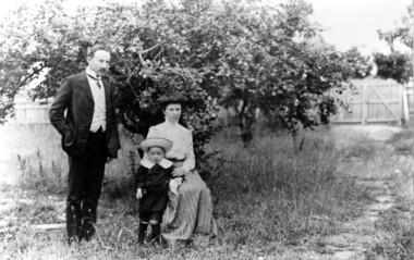
Photograph, Dr James Blakie, his wife Catherine and son Ray, c1912, c1912
The donor identified this as having been taken in the orchard area of 'Edgeware', the property on the corner of Montrose Street and Union Road in Surrey Hills where the Blakie family lived and from which Dr Blakie practiced. The gate opened to Union Road and the orchard was the area later developed as the shops at 157-165 Union Road. The property was rented from the Zeplin family. This would have been taken shortly before Dr Blakie moved across the road to 174 Union Road - the Surrey Hills Medical Centre. He purchased the land and has architect Arthur Plaisted design a home and surgery for him. Family details: James Blakie was born in New Zealand to a farming family of Scottish origin. He trained at Otago University with additional study at Cambridge. He married Catherine Miller Martin in 1906. They had 4 children: Geoffrey Noel (1906-1955); Raymond James (1907-1989); Theodore (1913-1913) and a daughter.Black and white photo of Dr James Blakie standing with Mrs Blakie, seated, and young son Ray standing beside his mother in an area with rough grass. Behind them is a large tree beyond which can be seen a timber paling fence with double gates from which leads a rough path.Number on back in pencil.doctors, edgeware, miss catherine miller martin, mrs catherine miller blakie, dr james landells blakie, mr raymond james blakie, union road, zeplin family -
 Surrey Hills Historical Society Collection
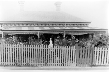
Photograph, Dr Blakie's home and surgery, 171 Union Road, Surrey Hills
The photo would have been taken prior to 1913 as Dr Blakie moved across the road to 174 Union Road to a purpose-built home/surgery designed by architect Arthur Plaisted. He practised at 171 Union Road joining or taking over from Dr Percy Liddle in 1905. The property was rented from the Zeplin family who built the house in 1890, which was known as 'Edgeware', and originally owned all the land bound by the railway, Union Road, Wilson Street and Montrose Street. in the 1920s to 1930s. 1906 became the home of Dr James Blakie, surgery was to the left of house. In 1912 Blakie had house built opposite (now Medical Centre). In 1920s-30s 'Edgeware' became Surrey Hills Police Station. Family details: James Blakie was born in New Zealand to a farming family of Scottish origin. He trained at Otago University with additional study at Cambridge. He married Catherine Miller Martin in 1906. They had 4 children: Geoffrey Noel (1906-1955); Raymond James (1907-1989); Theodore (1913-1913) and a daughter.Black and white photo of a Victorian style home with a slate roof, 2 chimneys, and a striped corrugated iron front veranda to 2 sides with decorative iron fretwork. It has a picket fence and an established garden with a central path leading to the front door. A woman, identified as Nurse Jones, is standing on the veranda.victorian style, homes, edgeware, house names, union road, montrose street, surrey hills, police station, zeplin family, professor zeplin, doctors, medical services, nurses, nurse jones, dr james landells blakie, dr percy liddle, mrs catherine miller blakie, raymond james blakie, geoffrey noel blakie, surrey hills police station, arthur plaisted, architects, edgeware, house names, 1890-1900 -
 Surrey Hills Historical Society Collection
Planning report, City of Boroondara, City of Boroondara planning report re 171 Union Road, Surrey Hills, 19/07/2004
171 Union Road was part of the Thomas Zeplin estate. It originally had a Victorian house on it built by the Zeplin family. This was leased by Dr Percy Liddle and then Dr James Landells Blakie. Dr Blakie purchased land diagonally opposite at 174 Union Road and had a purpose-built home / surgery constructed. Later the site was occupied by COR then a BP petrol station.A detailed proposal regarding the redevelopment of the petrol station site on the corner of Union Road and Montrose Street, Surrey Hills into a 2 storey office and shop building with basement parking and access from Montrose Street. It includes attachments showing plans, elevations and details regarding objectors. The application was granted subject to additional conditions being met. union road, redevelopment, shops, town planning -
 Albert Park-South Melbourne Rowing Club
Moore Sculling Machine
"Grace Blake’s conversations with older members of the Club have elicited the following information during July 2014: • Don Christie recalls the machine being acquired by (or donated to) SMRC in the 1960s. SMRC later donated it to APRC. • Bob Duncan remembers it being at APRC. • Max Shaw joined the club in 1946 but doesn’t recall it at all. • Peter Watson recalls collecting the rowing machine from the old APRC club house before its demolition (c. 1995). The AP-SMRC machine carries a ‘maker’s plate’ with the name Moore... Moore Crane and Engineering Company Pty Ltd was a subsidiary of Malcolm Moore Industries Ltd whose manufacturing engineering works were located on Williamstown Road, Port Melbourne from 1927. The founder established the main business in 1921 and retired in 1953.21 The business was delisted from the Australian Stock Exchange in 1976. Grace Blake advises that some of the earlier SMRC members were plumbers and therefore worked in trades connected with engineering. She reports that Peter Watson recalls some of his contemporaries completing their engineering apprenticeships at Malcolm Moore Industries Ltd in the 1970s. There are still many unanswered questions concerning the history and provenance of the rowing machine at the time of writing this report, but the connection with a local engineering works is certainly fascinating. Questions to explore in the future include: Did Moore manufacture the machine, or import it (and perhaps assemble it) under licence? Was this machine a ‘one-off’ or did Moore make / distribute others within Australia? When, why and how did SMRC acquire the machine? Why did SMRC decide not to retain it, but to pass it over to APRC? And how did APRC use it?" 2014 Significance Assessment, pp38-40. "The ‘Moore’ Rowing Machine at the Albert Park – South Melbourne Rowing Club (AP- SMRC) is a rare example in Australia of the Kerns patent design from 1900. This machine may not, however, be that old in construction or use. The AP-SMRC machine is almost intact, appearing to lack only the leather straps for fastening the rower’s feet to the foot-rests. Spalding manufactured the design in the USA in the early decades of the 20th century, but the metal elements in its models are traditionally black. The bright red paint on the AP-SMRC machine suggests something different. The AP-SMRC machine carries a maker’s plate that associates it directly with a local engineering business, Malcolm Moore Industries Ltd of Williamstown Road, Port Melbourne. Club members recall the machine being at the South Melbourne Rowing Club in the 1960s, and being transferred at a later date to the Albert Park Rowing Club. The machine has not been used since the founding of the amalgamated AP-SMRC and requires careful conservation. The ‘Moore’ rowing machine is of national research significance as a rare survivor, in Australia, of the well-regarded Kerns patent design that was popularised by Spalding in the northern hemisphere. The English River and Rowing Museum website quotes a testimonial from an AG Spalding & Bros’ Mail Order Catalogue: ‘This machine was described by ‘an experienced oarsman’ ... “to be the most perfect rowing machine ever produced”. A feature was the adjustment of the resistance so “the weaker sex can use the machine”’. Its historic significance lies in its rarity (and perhaps uniqueness) as an aid to the training of rowers at two successful clubs on Albert Park Lake. Additional historic significance lies in the connection that the rowing machine represents between local rowing clubs and a major local manufacturing engineer. The ‘Moore’ rowing machine bridges the realms of innovation and application, of industry and recreation, of land-based and aquatic sports, and of two neighbouring rowing clubs on the Albert Park Lake." 2014 Significance Assessment, p43"A rowing machine that appears to be built to the Kerns patent design from 1900 but may not be that old in construction or use. The machine is heavy and includes parts made from cast iron. The cast iron components are painted in a distinctive bright red. The wooden seat moves on timber slides. Resistance is created by spring mechanisms at the ends of two frame elements that connect with two wooden ‘oars’, and by the central chain-driven system that co-ordinates with the rower’s movements. The machine carries a maker’s plate with the single word ‘Moore’ in an oval design, using white letters against a navy background, fastened to the base board and close to the foot-rests." 2014 Significance Assessment, p38Moorerowing, apsm rowing club, significance assessment, malcolm moore industries ltd, kerns, 1900, sculling machine, albert park rowing club, south melbourne rowing club, albert park lake, rowing machine, ergo -
 Surrey Hills Historical Society Collection
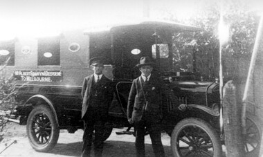
Photograph, Bus Service from Mont Albert, Balwyn, Deepdene to Melbourne
Man on the right is believed to be Mr Bowyer. A Mr Bowyer farmed land just east of Mont Albert Station around about the turn of the century - not known if there is any connection with that family. Car believed to be a 'T' Ford; driver and owner: Mr Bowyer; thought to have been taken in the early 1920s. We would like additional information or confirmation. A black and white copy of a photograph showing two men standing in front of a bus with a sign on its side identifying its destination as from Mont Albert, Balwyn and Deepdene to Melbourne. Both men are wearing suits and hats. Mr Bowes of Mont Albert(mr) bowyer, bovill family, transport, bus service, mont albert, deepdene, balwyn, t ford, (ms) ellena biggs -
 Surrey Hills Historical Society Collection
Photograph - Mont Albert Primary School, 1926
This was reproduced from a copy of the 1926 flyer relating to the Annual Speech Night. See vertical file re Mont Albert Primary / Mont Albert Central School. It was reproduced with the consent of the school archives in the early 1980's by Kenneth Tudor Hall. Mont Albert Primary was built in 1917 and was designated as a Central School in 1918 when Forms 1 & 2 were added. It remained as such until the 1964 when the secondary years formed the basis of a new high school, known as the Box Hill North High School, (later changed to Koonung Secondary College). The original building was constructed of solid red brick and consisted of seven rooms. In May 1924 a further four rooms, also in red brick, were added. The school opened with an initial enrolment of 147 students in Prep to Grade 6. A further 72 children were admitted during the year, making a total enrolment in the first year of 219. The land facing Kenmare Street was purchased in 1919, adding another 2 acres to the 5.5 acres which the school occupied in 1917. The first Principal was Charles Hyland, who was assisted by three teachers. The first official meeting of the School Council in May 1917 reveals that the building was in some senses a shell, requiring additional input from parents. Mention is made of the need for asphalting of playing areas, providing a letter box and electric lights for the lobby, double room, office and sewing room. Mont Albert was the first School in Victoria to have the interior purely constructed of Victoria hardwood, from floor to ceiling. An Honour Board was erected in 1919. mont albert central school, mont albert primary school, mont albert, schools -
 Surrey Hills Historical Society Collection
Photograph - Mont Albert Primary School, 1926
This was reproduced from a copy of the 1926 flyer relating to the Annual Speech Night. See vertical file re Mont Albert Primary / Mont Albert Central School. It was reproduced with the consent of the school archives in the early 1980's by Kenneth Tudor Hall. Mont Albert Primary was built in 1917 and was designated as a Central School in 1918 when Forms 1 & @ were added. It remained as such until the 1964 when the secondary years formed the basis of a new high school, known as the Box Hill North High School, (later changed to Koonung Secondary College). The original building was constructed of solid red brick and consisted of seven rooms. In May 1924 a further four rooms, also in red brick, were added. The school opened with an initial enrolment of 147 students in Prep to Grade 6. A further 72 children were admitted during the year, making a total enrolment in the first year of 219. The land facing Kenmare Street was purchased in 1919, adding another 2 acres to the 5.5 acres which the school occupied in 1917. The first Principal was Charles Hyland, who was assisted by three teachers. The first official meeting of the School Council in May 1917 reveals that the building was in some senses a shell, requiring additional input from parents. Mention is made of the need for asphalting of playing areas, providing a letter box and electric lights for the lobby, double room, office and sewing room. Mont Albert was the first School in Victoria to have the interior purely constructed of Victoria hardwood, from floor to ceiling. An Honour Board was erected in 1919. mont albert central school, mont albert primary school, mont albert, schools -
 Bacchus Marsh & District Historical Society
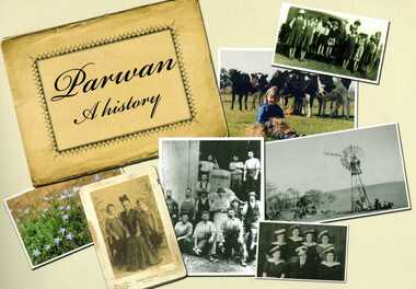
Book, Parwan: A History, 2010
Explores the history of the small farming community on the outskirts of Bacchus Marsh. It contains a plethora of fascinating details about the early years of this farming community from the 1830s until the early 2000s. There is a brief section at the beginning which looks at the history of the area prior to the colonial era. The book contains numerous sections about families and individual people who have lived in the Parwan area and includes many images of places and people. Citation: Parwan: A History by Dianne Van Leuvan. Published by Parwan History Group, Bacchus Marsh, Vic., 2010.Paperback printed book. 128 pages. with illustrations and photographs, some coloured. Includes facsimiles, maps, and index. Includes a separate folded sheet inside a pocket which has a reproduction of a map of the Parwan Parish in the County of Grant. On the reverse of this sheet are two reproductions. One is a land auction plan for February 1910 advertising the sale of portions of land from the Nerowie Estate. The other reproduction is a section of a map showing some of the blocks of land in the Nerowie Estate which has the heading, 'Nerowie Titles 1898'. A pocket inside the back cover contains a separate booklet which is an index, and two pages of 'Additional Information'.non-fictionExplores the history of the small farming community on the outskirts of Bacchus Marsh. It contains a plethora of fascinating details about the early years of this farming community from the 1830s until the early 2000s. There is a brief section at the beginning which looks at the history of the area prior to the colonial era. The book contains numerous sections about families and individual people who have lived in the Parwan area and includes many images of places and people. Citation: Parwan: A History by Dianne Van Leuvan. Published by Parwan History Group, Bacchus Marsh, Vic., 2010.parwan vic. history -
 Ringwood RSL Sub-Branch
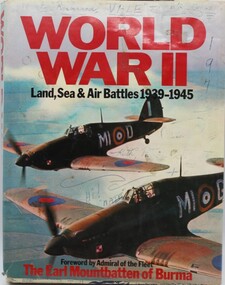
Book World War 2, World War 2 - Land Sea and Air Battles, 1977
Hard Cover with 253 pages containing colour, black and white maps and text.Assorted notingsAssorted notings on page 6.....VX52302. Additional notings also inside dust cover. -
 City of Kingston
Photograph - Colour, Paul Tresize, 1998
The name Mordialloc was derived from the name Moody Yallock, which comes from the Bunurong language. The Bunurong Peoples are the Traditional Owners of this area. The name means “high water” or “high creek”. In 1839, colonial authorities declared the mouth of the creek, and an additional 830 odd acres as an Aboriginal Reserve, although this proclamation was never gazetted. The reserved land included part of the Carrum Carrum Swamp which was abundant with wild life and natural resources. Regular encroachments, including land sales which began in 1863, were made on the land until 1878 when the Reserve was declared closed, and the land was opened up to land sales. Market gardening and suburban house lots quickly began to develop, and Mordialloc became a renowned picnic and holiday site. Mordialloc Creek is a popular bay side destination for local and visitors, and is a site for boating, kayaking, fishing and swimming, along with many other activities.Colour photograph of Mordialloc Creek, looking out to the bay. Many small fishing and leisure craft are moored on either side of the banks of the creek. To the right hand side can be seen parklands, while the left hand side has a small inlet in which more small crafts are moored.mordialloc, bunurong, traditional owners, suburbs, boats, fishing, waterways -
 City of Kingston
Photograph - Colour, 1998
The name Mordialloc was derived from the name Moody Yallock, which comes from the Bunurong language. The Bunurong Peoples are the Traditional Owners of this area. The name means “high water” or “high creek”. In 1839, colonial authorities declared the mouth of the creek, and an additional 830 odd acres as an Aboriginal Reserve, although this proclamation was never gazetted. The reserved land included part of the Carrum Carrum Swamp which was abundant with wild life and natural resources. Regular encroachments, including land sales which began in 1863, were made on the land until 1878 when the Reserve was declared closed, and the land was opened up to land sales. Market gardening and suburban house lots quickly began to develop, and Mordialloc became a renowned picnic and holiday site. Mordialloc Creek is a popular bay side destination for local and visitors, and is a site for boating, kayaking, fishing and swimming, along with many other activities.Colour photograph of Mordialloc Creek, looking inland.Small fishing and leisure boats are moored on either side of creek, with a view of the Mordialloc Bridge Hotel in the background.mordialloc, bunurong, traditional owners, suburbs, boats, fishing, waterways, hotel -
City of Kingston
Photograph - Colour, Paul Tresize, 1998
The name Mordialloc was derived from the name Moody Yallock, which comes from the Bunurong language. The Bunurong Peoples are the Traditional Owners of this area. The name means “high water” or “high creek”. In 1839, colonial authorities declared the mouth of the creek, and an additional 830 odd acres as an Aboriginal Reserve, although this proclamation was never gazetted. The reserved land included part of the Carrum Carrum Swamp which was abundant with wild life and natural resources. Regular encroachments, including land sales which began in 1863, were made on the land until 1878 when the Reserve was declared closed, and the land was opened up to land sales. Market gardening and suburban house lots quickly began to develop, and Mordialloc became a renowned picnic and holiday site. Mordialloc Creek is a popular bay side destination for local and visitors, and is a site for boating, kayaking, fishing and swimming, along with many other activities.Colour photograph of Mordialloc Creek, looking inland. Boats are moored on either side of the creek and the Bridge Hotel is visible in the background.mordialloc, bunurong, traditional owners, suburbs, boats, fishing, waterways, hotel -
 City of Kingston
Photograph - Colour, Paul Tresize, 1998
The name Mordialloc was derived from the name Moody Yallock, which comes from the Bunurong language. The Bunurong Peoples are the Traditional Owners of this area. The name means “high water” or “high creek”. In 1839, colonial authorities declared the mouth of the creek, and an additional 830 odd acres as an Aboriginal Reserve, although this proclamation was never gazetted. The reserved land included part of the Carrum Carrum Swamp which was abundant with wild life and natural resources. Regular encroachments, including land sales which began in 1863, were made on the land until 1878 when the Reserve was declared closed, and the land was opened up to land sales. Market gardening and suburban house lots quickly began to develop, and Mordialloc became a renowned picnic and holiday site. Mordialloc Creek is a popular bay side destination for local and visitors, and is a site for boating, kayaking, fishing and swimming, along with many other activities.Colour photograph of Mordialloc Creek with boats moored on both sides of the street and Pompei's boat yard visible on the right hand side of the creek., Main Street and St Brigid's Catholic Church are visible in backgroundmordialloc, bunurong, traditional owners, suburbs, boats, fishing, waterways, hotel, church -
City of Kingston
Photograph - Colour, Paul Tresize, 1998
The name Mordialloc was derived from the name Moody Yallock, which comes from the Bunurong language. The Bunurong Peoples are the Traditional Owners of this area. The name means “high water” or “high creek”. In 1839, colonial authorities declared the mouth of the creek, and an additional 830 odd acres as an Aboriginal Reserve, although this proclamation was never gazetted. The reserved land included part of the Carrum Carrum Swamp which was abundant with wild life and natural resources. Regular encroachments, including land sales which began in 1863, were made on the land until 1878 when the Reserve was declared closed, and the land was opened up to land sales. Market gardening and suburban house lots quickly began to develop, and Mordialloc became a renowned picnic and holiday site. Mordialloc Creek is a popular bay side destination for local and visitors, and is a site for boating, kayaking, fishing and swimming, along with many other activities.Colour photograph of Mordialloc Creek with boats moored on both sides of the street and Pompei's boat yard visible on the right hand side of the creek., Main Street and St Brigid's Catholic Church are visible in background.mordialloc, bunurong, traditional owners, boats, fishing -
 City of Kingston
Pamphlet - Black and white, Stott & Burke, Highland Estate Bentleigh, c.1915
Sales plan for land in the suburb of Bentleigh, along Collins and Ross Streets, bounded by Jasper Road.The developing urban area of Bentleigh within the City of Kingston. This land sale pamphlet illustrates the subdivision of land within the municipality and the changing demographic of the district as new houses are constructed.Black and white pamphlet advertising for private sale the Highland Estate, Bentleigh. Incorporates a map of the estate between Collins St and Ross St, bordered by Japser Road. Handwritten in grey pencil on map: additional subdivisions numbered 15-19 drawn along Ross St Handwritten in grey pencil on map: indecipherable annotations to subdivisions 1, 3 and 14land sales, bentleigh, estate -
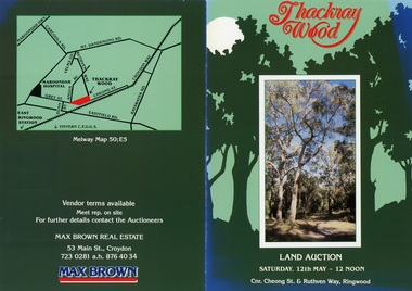 Ringwood and District Historical Society
Flyer, Land Auction Brochure - Thackray Wood, Ringwood East - circa 1984
Double sided bi-fold sales brochure regarding sale of 14 blocks of land comprising Thackray Wood, corner Cheong Street and Ruthven Way, Ringwood East. Agent: Max Brown Real Estate, 53 Main Street Croydon, Tel 7230281 a.h. 8764034. Inset image of additional copy with handwritten sale prices. -
 Bendigo Military Museum
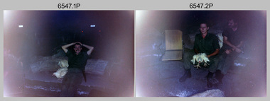
Photograph - 4th Field Survey Squadron Adventurous Training, Wilpena pound, Flinders Ranges, SA, 1989
This is a set of 43 photographs of a 4th Field Survey Squadron adventurous training held at Wilpena pound, in the Flinders Ranges of South Australia in 1989. It is evident the training focussed on teamwork, leadership, abseiling, rock climbing, field craft and living off the land survival skills. Elements from units of the Army Reserve also participated in the training. In this photo set, one of 4th Field Survey’s sections participated in abseiling and trekked to the highest mountain in the Flinders Ranges – St. Mary’s Peak. Refer to items 6553.56P for additional colour photographs taken during the adventurous training exercise.This is a set of 43 photographs of 4th Field Survey Squadron personnel undergoing adventurous training held at Wilpena pound, in the Flinders Ranges of South Australia in 1989. The black & white photographs are on 35mm negative film and are part of the Army Survey Regiment’s Collection. The photographs were scanned at 96 dpi. .1) - Photo, black & white, 1989. L to R: SGT Laurie Justin, SGT Stu Symonds. .2) - Photo, black & white, 1989. L to R: SGT Stu Symonds, CPL Roger Graf, SSGT Max Coletti, SPR Cheryl Deluca-Cardillo, SPR Andrew Quin. .3) & .4) - Photo, black & white, 1989. Wilpena Pound topography. .5) - Photo, black & white, 1989. SGT Stu Symonds. .6) - Photo, black & white, 1989. Abseiling ropes and equipment. .7) to .16) - Photo, black & white, 1989. Abseiling activities, unidentified soldier. .17) to .18) - Photo, black & white, 1989. Abseiling activities, CPL Michelle Griffith. .19) - Photo, black & white, 1989. L to R: unidentified (x5), SGT Mick Hogan, unidentified (x3). .20) - Photo, black & white, 1989. L to R: CPL Roger Graf, CPL Michelle Griffith, SPR Cheryl Deluca-Cardillo, SGT Laurie Justin, SSGT Max Coletti, SPR Andrew Quin. SGT Stu Symonds. .21) - Photo, black & white, 1989. L to R: unidentified (x2), SGT Stu Symonds. .22) & .23) - Photo, black & white, 1989. Wilpena Pound topography. .24) - Photo, black & white, 1989. SSGT Max Coletti. .25) - Photo, black & white, 1989. SSGT Max Coletti, SPR Cheryl Deluca-Cardillo, SGT Stu Symonds. .26) - Photo, black & white, 1989. SGT Stu Symonds. .27) - Photo, black & white, 1989. L to R: CPL Michelle Griffith, SPR Cheryl Deluca-Cardillo, SSGT Max Coletti, SGT Laurie Justin, SPR Andrew Quin, CPL Roger Graf, SGT Stu Symonds. .28) &.29) - Photo, black & white, 1989. Wilpena Pound topography. .30) - Photo, black & white, 1989. SGT Stu Symonds. .31) - Photo, black & white, 1989. CPL Michelle Griffith. .32) - Photo, black & white, 1989. L to R: CPL Michelle Griffith, SGT Stu Symonds, SSGT Max Coletti, SGT Laurie Justin. .33) - Photo, black & white, 1989. L to R: CPL Michelle Griffith, SGT Stu Symonds, CPL Roger Graf (standing), SSGT Max Coletti, SGT Laurie Justin. .34) - Photo, black & white, 1989. L to R: SGT Stu Symonds, CPL Michelle Griffith, CPL Roger Graf (standing), SSGT Max Coletti, SGT Laurie Justin. .35) to .37) - Photo, black & white, 1989. Wilpena Pound topography. .38) - Photo, black & white, 1989. SPR Cheryl Deluca-Cardillo. .39) - Photo, black & white, 1989. L to R: CPL Michelle Griffith, SGT Stu Symonds, SPR Andrew Quin, SGT Laurie Justin. .40) &.41) - Photo, black & white, 1989. Wilpena Pound topography. .1P to .43P – There are no personnel identified. ‘1989 ADV TRAINING’ annotated on negatives sleeve.royal australian survey corps, rasvy, 4 fd svy sqn -
Eltham District Historical Society Inc
Folder, George Fletcher, 1878
Folder of information on George Fletcher, Councillor, Steels Creek, 1878. Fletcher, George, Yarra Flats was born in Herefordshire, England, in 1830, and came to Australia, landing in Adelaide, S.A. in 1851. A year afterwards he came to Victoria, but after visiting the Bendigo goldfields and other places returned to Adelaide. In 1859, he again came to Victoria, was employed on the View Hill station, Yarra Flats, and stayed there for four years. In 1867 he selected 80 acres under the Land Act of 1865, and afterwards an additional 320 acres on Steel's Creek, where he now carries on faming and dairying. During htis time Mr. Fletcher has been a member of the board of advice for the east riding of the shire of Eltham, and about twelve years ago he was elected a member of the shire council, and continued so for a term. Mr Fletcher was married in 1859, and has a family of four sons and four daughters. From "Victoria and its Metropolis: Past and Present" written in 1888 by Alexander Sutherland. Chapter 19, "The Upper Yarra District" pages [402] - 415. Page 405. Includes descriptions of some townships and short biographies of local residents. george fletcher, steels creek, pioneer -
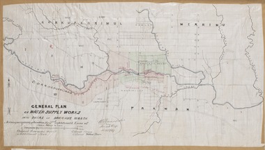 Bacchus Marsh & District Historical Society
Map, General Plan for Water Supply Works, Shire of Bacchus Marsh 1887
Debate about water supply and its planning and development took place in the Bacchus Marsh region from the 1850s through into the twentieth century. This plan was part of documentation to support an application for an additional loan of money from the Ministry of Water Supply to the Bacchus Marsh Shire Water Supply Trust. The plan includes the route of a proposed water channel in the Parwan area, and other features of water supply infrastructure such as the location of standpipes and gates are also shown on the plan.A single page paper map showing a general plan for the supply of water in the Bacchus Marsh area.The plan shows the route of the 'Main Channel' near the Werribee River and a proposed route for a Parwan Channel. The location of 'Dryden's House' near the Werribee River is also shown and the locations of land held by T. (Tom) Oliver and the Racecourse Reserve in Maddingley. Scale 40 chains to 1 inch. The plan is signed by Bacchus Marsh Shire Engineer, W.E. Standfield. The map is pasted into a bound volume containing 76 maps or plans in total. High resolution digital image stored on BMDHS computer network. General Plan of Water Supply Works in the Shire of Bacchus Marsh. Accompanying application for 2nd additional Loan. Original Waterworks district. Additional area. W.E. Standfield, 30/8/87.water supply, water supply maps, water supply bacchus marsh, irrigation, bacchus marsh victoria maps -
 Bendigo Military Museum
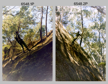
Photograph - 4th Field Survey Squadron Adventurous Training Mount Remarkable National Park, SA, 4th Field Survey Squadron Adventurous Training, Mount Remarkable National Park, SA, 1987
This is a set of 42 photographs of 4th Field Survey Squadron undergoing adventurous training at Mount Remarkable National Park, South Australia in May 1987. It is evident the training focussed on teamwork, leadership, abseiling, rock climbing, field craft and living off the land survival skills. Elements from units of the Army Reserve also participated in the training. Refer to items 6547.40P and 6548.14P for additional photographs taken during the adventurous training.This is a set of 42 photographs of 4th Field Survey Squadron undergoing adventurous training at Mount Remarkable National Park in May 1987. The colour photographs are on 35mm negative film and are part of the Army Survey Regiment’s Collection. The photographs were scanned at 96 dpi. .1) - Photo, colour, 1987. L to R: unidentified bus drivers, CAPT Danny Galbraith, unidentified, SGT Stu Symonds. .2) - Photo, colour, 1987. L to R: OC MAJ Peter Cates, SSM WO1 Bill Grigg, unidentified exchange officer. .3) - Photo, colour, 1987. Squadron briefing. .4) - Photo, colour, 1987. Endurance march L to R: unidentified (x4), LCPL Peter McCurdy, unidentified (x3), SPR Damien Killeen, unidentified. .5) - Photo, colour, 1987. Unidentified personnel taking a break during or at end Endurance march. SPR John Keely at far right. .6) - Photo, colour, 1987. Mount Remarkable National Park terrain. .7) - Photo, colour, 1987. Mount Remarkable National Park terrain. SGT Peter Imeson. .8) - Photo, colour, 1987. Mount Remarkable National Park terrain. CPL Jeff Prince. .9) - Photo, colour, 1987. Camp activities. CPL Dave Irving. .10) - Photo, colour, 1987. Camp activities. L to R: unidentified, SPR Perry Langeberg, unidentified (x2), CPL Neale ‘Tex’ Houston, SPR Steve Ellis. .11) to .13) - Photo, colour, 1987. Mount Remarkable National Park terrain. .14) - Photo, colour, 1987. Camp activities. Unidentified. .15) - Photo, colour, 1987. Camp activities. L to R: PTE P. Simpson, SPR Steve Ellis. .16) - Photo, colour, 1987. Hootchie set-up. Unidentified personnel. .17) - Photo, colour, 1987. Hootchie set-up. .18) - Photo, colour, 1987. Camp activities. Unidentified. .19) - Photo, colour, 1987. Camp activities. L to R: SPR Todd Hayley, CPL Jamie McRae. .20) - Photo, colour, 1987. Camp activities. L to R: unidentified, CPL Neale ‘Tex’ Houston, unidentified. .21) - Photo, colour, 1987. Camp activities. L to R: CPL Dave Longbottom, WO2 Brett ‘Dutchy’ Van Leeuwen. .22) - Photo, colour, 1987. Hootchie set-up. .23) - Photo, colour, 1987. Hootchie set-up. CPL Dave Irving. .24) - Photo, colour, 1987. Mount Remarkable National Park terrain. Possibly OC MAJ Peter Cates. .25) - Photo, colour, 1987. Mount Remarkable National Park terrain. .26) & .27) - Photo, colour, 1987. Hootchie set-up. .28) - Photo, colour, 1987. Camp activities. CPL Roger Graf. .29) - Photo, colour, 1987. Camp activities. Possibly water sterilisation. .30) - Photo, colour, 1987. Camp set-up. Unidentified. .31) - Photo, colour, 1987. Hootchie interior. .32) - Photo, colour, 1987. CAPT Danny Galbraith. .33) - Photo, colour, 1987. Camp activities. L to R: LCPL Peter Tuddenham, SPR Todd Hayley, CPL Dave Longbottom, CPL John Ratcliffe, CPL Dave Irving. .34) - Photo, colour, 1987. Hootchie set-up. .35) - Photo, colour, 1987. Hootchie set-up. CPL Peter Hardy. .36) - Photo, colour, 1987. Camp activities. L to R: unidentified (x2), CPL Peter Hardy, LT Greg Oaten. .37) - Photo, colour, 1987. Camp activities. L to R: SPR Shaun Hynes, LT Geoff ‘GT’ Ford, SPR Bruce Graham, unidentified (x2). .38) - Photo, colour, 1987. Camp activities. L to R: SPR Shaun Hynes, LT Geoff ‘GT’ Ford, unidentified, SPR Bruce Graham, in background - CPL Dave Irving. .39) - Photo, colour, 1987. Hootchie set-up. Unidentified. .40) - Photo, colour, 1987. Camp activities. WO2 Brett ‘Dutchy’ Van Leeuwen. .41) & .42) - Photo, colour, 1987. Camp activities. Results from foraging the forest for food..1P to .42P – There are no personnel identified. ‘1987 ADV TRAINING’ annotated on negatives sleeve.royal australian survey corps, rasvy, 4 fd svy sqn -
 Bendigo Military Museum
Photograph - 4th Field Survey Squadron Adventurous Training, Mount Remarkable National Park, Flinders Ranges, SA, 4th Field Survey Squadron Adventurous Training, Mount Remarkable National Park, SA, 1987
This is a set of 40 photographs of 4th Field Survey Squadron undergoing adventurous training at Mount Remarkable National Park, South Australia in May 1987. It is evident the training focussed on teamwork, leadership, abseiling, rock climbing, field craft and living off the land survival skills. Elements from units of the Army Reserve also participated in the training. Refer to items 6546.42P and 6548.14P for additional photographs taken during the adventurous training.This is a set of 40 photographs of 4th Field Survey Squadron undergoing adventurous training at Mount Remarkable National Park, South Australia in May 1987. The colour photographs are on 35mm negative film and are part of the Army Survey Regiment’s Collection. The photographs were scanned at 96 dpi. .1) - Photo, colour, 1987. Camp activities, unidentified soldier. .2) - Photo, colour, 1987. Camp activities, unidentified personnel. .3) & .4) - Photo, colour, 1987. Hootchie set-up. .5) - Photo, colour, 1987. Camp activities, unidentified personnel. .6) - Photo, colour, 1987. Hootchie set-up. .7) - Photo, colour, 1987. Camp activities. .8) - Photo, colour, 1987. Hootchie set-up, unidentified officer. .9) - Photo, colour, 1987. Camp activities. Results from foraging the forest for food. .10) - Photo, colour, 1987. Camp set-up. .11) - Photo, colour, 1987. Camp activities. .12) - Photo, colour, 1987. Camp activities. L to R: CPL Jeff Prince, unidentified (x3). .13) to .16) - Photo, colour, 1987. Camp activities. .17) & .18) - Photo, colour, 1987. Mount Remarkable National Park terrain. .19) - Photo, colour, 1987. Hootchie set-up. L to R: unidentified, CPL Jeff Prince, SPR Perry Langeberg, unidentified (x3). .20) - Photo, colour, 1987. Camp activities. .21) - Photo, colour, 1987. Camp activities, unidentified personnel. .22) & .23) - Photo, colour, 1987. Camp set-up. .24) - Photo, colour, 1987. Hootchie set-up. .25) - Photo, colour, 1987. Hootchie set-up, unidentified personnel. .26) - Photo, colour, 1987. Camp activities. L to R: CPL Jeff Prince, SPR Steve Ellis, SGT Peter Imeson, CPL Neale ‘Tex’ Houston, SPR Perry Langeberg, unidentified exchange officer, WO2 Russ Larsen. .27) - Photo, colour, 1987. Hootchie set-up. .28) - Photo, colour, 1987. Camp activities. L to R: SPR Bruce Graham, LT Geoff ‘GT’ Ford, CPL Jamie ‘Fish’ McRae, SGT Wally Chilcott, SPR Shaun Hynes, CPL Kevin Whitty. .29) - Photo, colour, 1987. Camp activities. L to R: unidentified, SPR Todd Hayley, unidentified, WO2 Peter Symmans, SSGT Cam Chapman, CPL Dave Irving. .30) - Photo, colour, 1987. Camp activities. L to R: unidentified (x2), LT Greg Oaten, unidentified (x2), CPL Peter Hardy, unidentified. .31) - Photo, colour, 1987. Camp activities. L to R: CPL Roger Graf, WO2 Bob Rogister, SSM WO1 Bill Griggs, unidentified officer, SPR Simon Reynolds, SPR John Keely. .32) - Photo, colour, 1987. Camp activities. L to R: unidentified, SPR Steve Nokes, SGT Stu Symonds, WO2 Brett ‘Dutchy’ Van Leeuwen, unidentified (x3). .33) - Photo, colour, 1987. Camp activities. L to R: unidentified, SGT Derek Stanmore, CAPT Danny Galbraith, unidentified in foreground. .34) - Photo, colour, 1987. Camp activities. L to R: unidentified (x3), SGT Derek Stanmore, CAPT Danny Galbraith. .35) - Photo, colour, 1987. Camp activities. .36) - Photo, colour, 1987. Camp activities. OC MAJ Peter Cates. .37) - Photo, colour, 1987. Camp activities. L to R: unidentified, CPL Dave Longbottom. .38) - Photo, colour, 1987. Camp activities, unidentified personnel. .39) & .40) - Hootchie set-up..1P to .40P – There are no personnel identified. ‘1987 ADV TRAINING’ annotated on negatives sleeve.royal australian survey corps, rasvy, 4 fd svy sqn -
 Bendigo Military Museum
Photograph - 4th Field Survey Squadron Adventurous Training, Wilpena pound, Flinders Ranges, SA, 1987
This is a set of 14 photographs of a 4th Field Survey Squadron undergoing an abseiling activity, as part of adventurous training held at Mount Remarkable National Park, South Australia in May 1987. It is evident the training focussed on teamwork, leadership, abseiling, rock climbing, field craft and living off the land survival skills. Elements from units of the Army Reserve also participated in the training. Refer to items 6546.42P and 6547.40P for additional photographs taken during the adventurous training exercise.This is a set of 14 photographs of 4th Field Survey Squadron personnel undergoing an abseiling activity, as part of 4th Field Survey Squadron adventurous training held at Mount Remarkable National Park of South Australia in May 1987. The colour photographs are on 35mm negative film and are part of the Army Survey Regiment’s Collection. The photographs were scanned at 96 dpi. .1) - Photo, colour, 1987. Abseiling activities, SSM WO1 Bill Griggs. .2) to .14) - Photo, colour, 1987. Abseiling activities, unidentified soldier..1P to .14P – There are no personnel identified. ‘1987 ADV TRAINING’ annotated on negatives sleeve.royal australian survey corps, rasvy, 4 fd svy sqn -
Kew Historical Society Inc
Journal - Visitor Book, Fairyland Book
"Fairyland", the home of Jim and Grace Tabulo, was a notable local, state and international tourist attraction situated in Kew, Victoria during the mid twentieth century. Located at 57 Malmsbury Street, Kew, the weatherboard house and its garden were heavily decorated with statues, crockery and other collected items. A series of notebooks were used to record the messages of child and adult visitors to the property from the 1940s to the 1960s. After Mrs Tabulo's death, these visitor books are believed to have formed part of the Dorothy Rogers Collection. They entered the Kew Historical Society's collection following Dorothy Roger's death in 1973.This series of visitor books are the most important primary sources relating to the internationally renowned 'Fairyland' cottage in Malmsbury Street, Kew. Their social significance is that they record in the post war period the values and beliefs of children and adults who visited this historically significant tourist attraction.Foolscap size visitor book containing handwritten comments and drawings primarily made by children during visits to the home of Grace Tabulo, c.1950-1960. Commonly known as "Fairyland", the house was located at 57 Malmsbury Street Kew. The book is wrapped in brown paper, which covers back cardboard covers with a red cloth strip binding. Unpaginated, approximately 160 pages, and covers. The book has an additional loosely inserted black card cover located at the front of the book.Handwritten in pencil on paper cover: "1950 - 1962 /(edit book dates)" Handwritten in ink on paper label on loosely inserted cover: "Fairy Land / Book/ September 1950 / Fairy Land / Book / 75 [sic] M...berry [indistinct] st Kew / Fairy Land Book"grace tabulo -- fairyland -- 57 malmsbury street -- kew (vic.), tourism - kew - 1945-1965, childhood - kew, collectors and collecting, gardens - kew (vic), scrapbooks - 20th century -
 Eltham District Historical Society Inc
Photograph - Digital Photograph, Alan King, Maroondah Aqueduct Siphon Bridge over the Plenty River, 26 January 2008
Opened in 1891, the bridge formed part of the Maroondah Aqueduct carrying water from Watts River near Healesville to the reservoir at Preston where it joined Melbourne's metropolitan water system. Covered under Heritage Overlay, Nillumbik Planning Scheme. Published: Nillumbik Now and Then / Marguerite Marshall 2008; photographs Alan King with Marguerite Marshall.; p99 Built to supply thirsty Melbourne in the late 19th century, the siphon bridge spanning the Plenty River off Leischa Court, Greensborough, was part of an engineering masterpiece. Opened in 1891, the bridge formed part of the Maroondah Aqueduct carrying water from the Watts River near Healesville to the reservoir at Preston where it joined the metropolitan distribution system. A major link in Melbourne’s water supply, it also had a huge impact on communities, which mushroomed along its route. Named after the Aboriginal word for the area around the Maroondah Reservoir, the Maroondah Aqueduct was fully operational until the 1970s. Since the 1980s the land along parts of the aqueduct have been used for walking and bicycle riding, shaded in places by Monterey Pine trees planted to stabilise the surrounding ground. From 1857 the Yan Yean Reservoir supplied Melbourne’s water but the growing city needed additional catchments.1 In 1886 work began on a weir on the Watts River to enable the aqueduct to carry most of the river water 41 miles (66km) to Melbourne. The aqueduct, built by the Board of Works, is the oldest remaining aqueduct near Melbourne and was probably the first built with concrete.2 Although the aqueduct is now only used between the Maroondah and Sugarloaf Reservoirs, it can still be traced across the Shire. It extends from the Maroondah Reservoir through Christmas Hills, Kangaroo Ground, Research, Eltham, St Helena and then previously wound west through Greensborough to Reservoir.3 Built by horse and manpower the aqueduct gravity fed 25 million gallons (113.6ML) of water a day to Melbourne along a gradient of one foot to the mile. It included 25 miles (41km) of open concrete and brick channel, six miles (10km) of tunnels, and nine miles (15km) of 14 inverted siphons of riveted wrought-iron across creeks. Bricks for the aqueduct were made from clay found near the sites and remains of several kilns can still be found between Kangaroo Ground and Christmas Hills. Building the aqueduct transformed local communities. An abattoir was established at Christmas Hills. Grog shanties and labourers’ camps sprang up and local courts dealt with cases of ‘petty pilfering and boisterous behaviour’.4 The Kangaroo Ground school population jumped to 91, crammed into a room with one teacher. Miners who built the tunnels camped just north of Churinga in Greensborough – then called Tunnel Hill Camp – and adjacent to the Evelyn Arms Hotel. The miners’ high spirits were sometimes quenched in horse troughs or by a ‘welt under the ear and kick on the behind’ as the local constable calmed them down rather than lock them up.5 But the growing city of Melbourne needed more water, so the O’Shannassy catchment, east of Warburton, was added to the system in 1914. In 1920 work began on the present concrete Maroondah Dam one mile (1.6km) from the weir on the Watts River. The aqueduct capacity was thus doubled to 50 million gallons (227ML) a day.6 Intense land development threatened to pollute the open water supply, so channel sections were replaced with large pipes. In the late 1960s a large water main was built from the tunnel outlet at Research and extended through St Helena and Greensborough, so this section of the aqueduct was taken out of use. Long sections of the unused open channels in Greensborough and Bundoora were destroyed, but the old channel in Research and Eltham North remained largely intact. In the 1970s, the Sugarloaf Reservoir was constructed, inundating 445 hectares of land in Christmas Hills. Sugarloaf was officially opened in 1980 and serves as a water storage and treatment plant supplying Melbourne. In the early 1980s pipes replaced the section from Sugarloaf Reservoir to the tunnel entrance at Kangaroo Ground. The Research-Kangaroo Ground tunnel operates as part of the pipeline system.This collection of almost 130 photos about places and people within the Shire of Nillumbik, an urban and rural municipality in Melbourne's north, contributes to an understanding of the history of the Shire. Published in 2008 immediately prior to the Black Saturday bushfires of February 7, 2009, it documents sites that were impacted, and in some cases destroyed by the fires. It includes photographs taken especially for the publication, creating a unique time capsule representing the Shire in the early 21st century. It remains the most recent comprehenesive publication devoted to the Shire's history connecting local residents to the past. nillumbik now and then (marshall-king) collection, maroondah aqueduct, pipe bridge, siphon bridge -
 Eltham District Historical Society Inc
Photograph - Digital Photograph, Alan King, Edendale Farm Homestead, 29 January 2008
Edendale Farm is Nillumbik Shire Council's environment centre situated in Gastons Road, Eltham between the railway and the Diamond Creek. The homestead on the property was built in 1896 and is of historical significance, being the subject of a Heritage Overlay under the Nillumbik Planning Scheme. The Edendale property was originally part of an extensive land purchase in 1852 from the Crown by pioneer Eltham farmer Henry Stooke. He initially purchased 51 acres and later expanded his holdings by purchasing another three adjacent Crown allotments extending northerly from Josiah Holloway's Little Eltham subdivision. Despite clearing the land, Stooke did not build on this property, choosing to live on his property "Rosehill" at Lower Plenty. In 1896 Thomas Cool, Club Manager of the Victoria Coffee Palace in Melbourne purchased 7 acres of the original Stooke land and built the house now known as Edendale. Cool did not farm the land, instead using it as a gentleman’s residence, retiring to Eltham at weekends. In 1918 he purchased an additional 7 acres but in 1919 he sold the property. Later owners included J.W. Cox, the Gaston family and D. Mummery. In the 1980s the Eltham Shire Council purchased the site for use as a Council depot, but this use did not proceed. Subsequently, it was used as the Council pound. The Edendale Farm Pet Education and Retention Centre was established in the summer of 1988/1989 and was set up to replace the existing dog kennels with a high standard pet retention centre. The design style of the building was established to compliment the features of the existing house. It was equipped with 10 retention pens, a veterinary room and a pet education area where school children and other interested parties learnt about pet care procedures. It was later developed into a community farm and was run by an advisory committee and in 2000 it became an Environment Centre. In early 2006 an advisory committee was established for the development of a master plan for future development at Edendale Farm. The committee included Russell Yeoman, a former long-time shire planner and founding member of the Eltham District Historical Society. At the time of filming the Master Plan and future for Edendale was about continuing to develop Edendale as a centre of environment learning and looking at expanding displays and school program, running a lot more of life-long learning and workshops around sustainable living. Covered under Heritage Overlay, Nillumbik Planning Scheme. Published: Nillumbik Now and Then / Marguerite Marshall 2008; photographs Alan King with Marguerite Marshall.; p101 A sharp turn from busy Wattletree Road by the railway line, brings a surprise. Only 1.4 km from Eltham’s centre, sheep feed, blissfully unaware of the hectic suburban activity so close by. At the entrance to the 5.6ha Edendale Farm is another surprise. A work of art that looks like huge tree trunks transformed into bowler and top-hatted men. The Fences Act 1968 by Tony Trembath with Mark Cain and John Doyle, 1996, is classified by the National Trust of Australia as having Regional Significance. The title refers to a government act on disputes between neighbors over the placement of fences and boundaries. This takes a ‘wry swipe’ at a community divided by trivial squabbles. It also celebrates making do with limited resources.1 Further along on the left, the office wall is decorated with a massive Eltham Copper Butterfly, designed by Robert Tickner and made by school children with used plastic bottles and other waste material. Nillumbik Council runs Edendale as an Environmental Education Centre, to help preserve and enhance the local environment. As early as 1988 the former Eltham Shire Council realised Edendale’s importance in meeting people’s needs, particularly of children, to enjoy farmland. The centre, with the Eltham North Reserve to the north - including remnant bushland and open parkland - makes up the major part of the public open space for this area. The council considers this area will become increasingly important to the local community for recreational use.2 Educational programs aim to encourage community involvement to ensure the long-term rehabilitation and protection of natural bushland areas. Edendale is used by people of all ages - from school children to adults - for environmental programs and workshops, as well as for recreation, to enjoy the domestic animals and to picnic. Edendale is also home to the Environmental Works staff who manage reserves and roadsides and support Nillumbik Friends environmental groups. The Friends propagate plants at the nursery, which grows indigenous plants and sells these to the public.3 The centre demonstrates the sustainable living the farm teaches, with features like solar hot water and drive lighting and for the fireplace, logs of recycled cardboard. Edendale has had a varied history as a dog pound and even as a retreat for Thomas Cool, Club Manager of the Victoria Coffee Palace in Melbourne. His single-storey weatherboard house built in 1896, which still stands, was grander than most homes in Eltham. Although such buildings were common in many other parts of Melbourne, Eltham’s poverty and remoteness did not encourage such construction. The Victorian rectangular-shaped house, with a corrugated iron roof and veranda, has elegant large rooms, leadlight windows, ceiling roses, two bay windows and ornately carved wooden fireplace surrounds. Cool bought seven acres (2.8ha) from pioneer Eltham farmer Henry Stooke’s 200 acre (81ha) farm, which he had bought from the Crown in 1852. In 1918 Cool bought an extra seven acres (2.8ha) but in 1919 sold the estate to farmer John Cox. In 1933 Cox sold Edendale to Mrs Elizabeth Gaston, after whom the road leading to the centre was named. The property was owned by several Gaston family members, who called it Edendale, then by a police constable, Douglas Mummery, until the Shire of Eltham bought it in 1970. Oddly Edendale was known as Mummery’s for almost 20 years, although Mummery owned it only for a short time.4 The shire used Edendale as a dog pound until amalgamation with other municipalities in 1996. The pound then moved to the Yan Yean Road, Plenty site, which had been used by the former Diamond Valley Shire Council. To the west and north the centre is bounded by Diamond Creek and on the east by the Melbourne-Hurstbridge railway line. Part of the Research creek forms the centre’s southern boundary.This collection of almost 130 photos about places and people within the Shire of Nillumbik, an urban and rural municipality in Melbourne's north, contributes to an understanding of the history of the Shire. Published in 2008 immediately prior to the Black Saturday bushfires of February 7, 2009, it documents sites that were impacted, and in some cases destroyed by the fires. It includes photographs taken especially for the publication, creating a unique time capsule representing the Shire in the early 21st century. It remains the most recent comprehenesive publication devoted to the Shire's history connecting local residents to the past. nillumbik now and then (marshall-king) collection, edendale farm