Showing 106 items matching "ballan"
-
 Ballan Shire Historical Society
Map - Map. Bungal, Department of Lands and Survey, Bungal, County of Grant, 09/09/1926
A map of Bungal in the 1920's showing the allotments, and the size, with the names of the residents. It shows the roads and the Western and Eastern Moorarbool River, and the Whipstick State Forest.Cream coloured map of Bungal in the County of Grant, bounded by the the East Moorarbool River on the East, and the State Forest on the South. It is marked with the scale of chains and the number L.358. Lithographed at the Department of Lands and Survey. Melbourne by W. J. Butson on 9.9.1926. It shows the land allotments with names of owners.Coloured pen marks and circled numbers on various areas. Price 2 shillings marked on bottom right hand edge.bungal, kerrit bareet, egerton, lal lal, borhoneyghurk, bungeeltap, ballark, yaloak, gorong, moorarbool west -
 Ballan Shire Historical Society
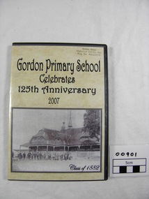
DVD. Gordon P/S, Gordon Primary School Celebrates 125th Anniversary 2007, 2007
This DVD was produced to celebrate the 125th Anniversary of the Gordon Primary School in 2007. It is a pictorial history covering that period consisting of still photographs in a slide show format.DVD in a plastic case with a custom printed cover insert depicting a photograph of Gordon Primary School Class of 1882. Contains still photographs of staff, students, school grounds, functions, etc. over the last 125 years. A pictorial history set out in five (slide show) chapters with a sound track to accompany. DVD compiled and designed by Diane Lawson 2007. All proceeds from the sale of this DVD will be donated to the Gordon Primary School.school, gordon, primary school, 125th anniversary -
 Ballan Shire Historical Society
Map - Map. Ballark, Department of Lands and Survey, Ballark. County of Grant, 31/08/1915
A map of the Ballark area within the County of Grant showing roads, waterways, property boundaries and property owners in 1915.Significant to people researching land usage and ownership. Also those researching families in the area at that time.A map of Ballark in the County of Grant. Black printing on buff coloured paper. Extra notations by hand and various coloured highlighting of certain features. Details roads, rivers, property boundaries and names of property owners and districts. The map is easily readable although there is some physical damage to the borders and some sellotape residue. Shows a scale in Chains and the number L.6030Various numbers and directional arrows added to map.bungal, borhoneyghurk, bungeeltap, ballark, beremboke, moreep, meredith, morrisons, moorarbool river -
 Ballan Shire Historical Society
Map - Map. Kerrit Bareet, Department of Lands and Survey, Kerrit Bareet. County of Grant, 08/1944
A map of the Kerrit Bareet area within the County of Grant showing properties and names of owners in 1944.Significant to people researching land usage and ownership. Also those researching families in the area at that time.A map of Kerrit Bareet in the County of Grant. Black printing on buff coloured paper. Details roads, rivers, railways, property boundaries and names of property owners and towns and villages. The map is easily readable although there is some physical damage and that and the borders have been reinforced with sellotape. Shows a Scale in Chains and Price 2/.gordon, bungal, kerrit bareet, lal lal, moorarbool river, warrenheip, bungaree, wallace, moorarbool west -
 Ballan Shire Historical Society
Map - Map. Bullarook State Forest, Bullarook State Forest Reserve
A small map of the Bullarook State Forest Reserve. Drawn on a fine buff coloured paper attached to a stiff cloth backing sheet. The title is hand written and includes a "scale one mile to one inch" hand written also. The map is signed "John Wrigglesworth, assistant ? and dated 26/6/1869" although the month and year are almost illegible.moorabool west, state forest, bullarook, eastern moorabool river, werribee river, moorabool east, blakes saw mill, wombat, andersons saw mill -
 Ballan Shire Historical Society
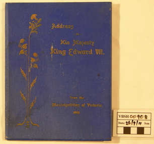
Book - Book. Address to King Edward VII, McCarron Bird and Co, Address to His Majesty King Edward VII. from the Municipalities of Victoria 1901, 1901
The book contains the Joint Address to His Most Gracious Majesty King Edward the Seventh from the Municipalities of Victoria, and is dated Melbourne, 30th January 1901. It contains the Cities, Towns, Boroughs, and Shires with the signatures of the chief officers of each and signatures of the Executive and Executive Committee of the Municipal Association of Victoria.A thin hard cover book with a royal blue cover and gold leaf title title with an upright leaf embellishment on the left. Book No.108. 16 pages.With the compliments of the Executive Committee of the Municipal Association of Victoria.king edward v11, municipal association of victoria, royal visit 1901 -
 Ballan Shire Historical Society
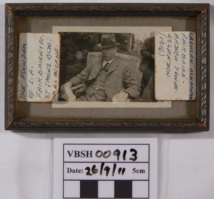
Photograph - Photograph. L A Fairbairn, Lachlan Alexander Fairbairn, 1916
There is not much information on this item at the moment. The record will be updated when more becomes available.A small black and white photograph of L.A. Fairbairn sitting in a wicker chair outdoors. The photograph is under glass in a small timber frame with scrolled upper edges.Labels stuck on the glass read - " the founder of L.A. Fairbairn 7 Co. St. James Bldg Melbourne" and "Lachlan Alexander Fairbairn - Ardoch tower-Essendon (1916)". A sticker, D4, is on the back of the frame.fairbairn lachlan alexander, l a fairbairn co -
 Ballan Shire Historical Society
Map - Map. Korweinguboora, Department of Lands and Survey, Korweinguboora. Counties of Talbot and Grant
A map of the Korweinguboora area showing roads, forests, railway lines and properties with the owners names.The inclusion of the names of landowners is of significance and value to historians.A map of the Korweinguboora area showing land subdivisions and names of owners and other physical features. There is a scale in chains. No date is certain but it could be 1902. The map has been repaired with sellotape.There are various pencil annotations but the are difficult to read.talbot, moorarbool west, wombat, bullarto, korweinguboora, moorarbool east, dean, wombat state forest, barkstead -
 Ballan Shire Historical Society
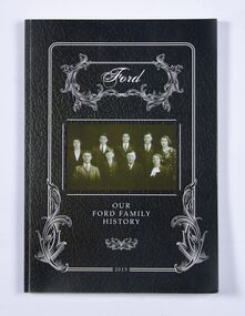
Book - Book, Ford - Our Ford Family History, 2015
A history of the Ford Family and descendants, pioneer settlers of the Morrisons/Meredith area in Victoria. Contains photographs, family trees, documents, newspaper cuttings, maps, narratives etc. Black and white only.This book is significant in that it contains valuable historic information on the Ford and Brawn families. The publication is private and intended for the information and interest of family members and others researching the family.Book, soft cover, perfect bound, with a leather look cover and a photograph of family members with a scrollwork surround.ford, brawn, bant -
 Ballan Shire Historical Society
Album (collection) - DVD - Our Ford Family, Our Ford Family, 2015
ford, brawn, bantford, brawn, bant -
 Ballan Shire Historical Society
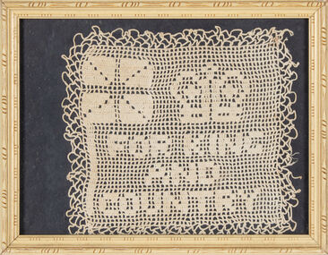
Craft - Doily, Jones, Isabella, For King and Country, c. 1914
A memento created during WW1 A doily crochet in cotton, mounted on a black background, placed under glass in a cream coloured timber frame. The text "For King and Country" can be seen, also visible is a crown and a rudimentary Union Jack.jones isabella, barrett frances -
 Ballan Shire Historical Society
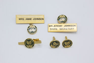
Badge - Ballan Shire Council name badges, cuff links and tie pin, 1980s
A set of cuff links, two name badges and a tie pin.johnson jeremy, johnson anne -
 Ballan Shire Historical Society
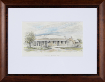
Painting, Edward Bonveventure Heffernan, Hanrahans Hotel, 1986
An original watercolour painting surrounded by a white backing under glass in a plain brown timber frame'Present site of Hudsons Hotel'. Edward Heffernan 86 Corner of Inglis and Stead St. 1914 -
 Bacchus Marsh & District Historical Society
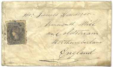
Document, Envelope used for letter to Mr James Henderson, Learmouth Mill, Coldstream, Northumberland, England. 1861
This envelope was used to post a letter or other similar document from Bacchus Marsh in Victoria around November 1861 to a Mr James Henderson in Coldstream, Northumberland, England. The contents inside the envelope have been lost and the sender of the envelope is not known. Postal services in Bacchus Marsh can be traced back to at least 1847 when Henry James of Bacchus Marsh was appointed postmaster for Bacchus Marsh replacing the service previously conducted from Ballan. Henry James conducted this postal service from his residence. This service was still designated as the Ballan Post Office until September 1850 when its name was formally changed to the Bacchus Marsh Post Office. The envelope of 1861 addressed to Mr Henderson in England is therefore a fairly early documentary artifact from users of the Bacchus Marsh postal service. An envelope used for a letter in 1861. An address in Norththumberland, England is written on the front of the envelope. It also shows a postage stamp depicting Queen Victoria of Great Britain. The postage stamp is a sixpence stamp produced in the colony of Victoria in the 1850s and 1860s. On the reverse of the envelope are 3 circular shaped post office marks: 'Bacchus Marsh Victoria No.25 1861'; 'Melbourne 1 Z No.25 61'; and 'Coldstream JA22 62'.envelopes, postal services, bacchus marsh post office -
 Working Heritage Crown Land Collection
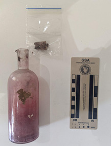
Container - Ink Bottle
Hand blown master ink bottle with fragments of paper insidearchaeology, historic building, ballan court house -
 Narre Warren and District Family History Group
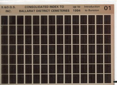
Film, Ballarat and District Genealogical Society Inc, Consolidated Index to Ballarat District Cemeteries Up to 1994, c1995
The index contains information for: Amhurst Cemetery; Avoca Cemetery; Ballan Cemetery; Beaufort Cemetery; Bungaree Cemetery; Buninyong Cemetery; Cape Clear Cemetery; Carngham Cemetery; Clarendon Cemetery; Clunes Cemetery; Coghills Creek Cemetery; Creswick Cemetery; Daylesford Cemetery; Dowling Forest Cemetery; Eganstown/Blanket Flat Cemetery; Eurenbeen East/Franklinford Cemetery; Gordon Cemetery; Greendale Cemetery; Learmonth Cemetery; Lexton Cemetery; Linton Cemetery; Majorca Cemetery; Maryborough Cemetery; Morrisons Cemetery; Mt Cole Cemetery; Mt Egerton Cemetery; Mt Prospect Cemetery; Newstead Cemetery; Rokewood Cemetery; Skipton Cemetery; Smeaton Cemetery; Smeaton House Cemetery; Smythesdale Cemetery; Staffordshire Reef Cemetery; Talbot Cemetery; Waterloo Cemetery and Waubra Cemetery.Set of 10 microfiche. non-fictionThe index contains information for: Amhurst Cemetery; Avoca Cemetery; Ballan Cemetery; Beaufort Cemetery; Bungaree Cemetery; Buninyong Cemetery; Cape Clear Cemetery; Carngham Cemetery; Clarendon Cemetery; Clunes Cemetery; Coghills Creek Cemetery; Creswick Cemetery; Daylesford Cemetery; Dowling Forest Cemetery; Eganstown/Blanket Flat Cemetery; Eurenbeen East/Franklinford Cemetery; Gordon Cemetery; Greendale Cemetery; Learmonth Cemetery; Lexton Cemetery; Linton Cemetery; Majorca Cemetery; Maryborough Cemetery; Morrisons Cemetery; Mt Cole Cemetery; Mt Egerton Cemetery; Mt Prospect Cemetery; Newstead Cemetery; Rokewood Cemetery; Skipton Cemetery; Smeaton Cemetery; Smeaton House Cemetery; Smythesdale Cemetery; Staffordshire Reef Cemetery; Talbot Cemetery; Waterloo Cemetery and Waubra Cemetery. cemeteries -- victoria -- ballarat, ballarat (vic.)