Showing 422 items matching "camp huts"
-
 Kiewa Valley Historical Society
Photograph - Mt Bogong - Tawonga, 06/05/1937
Mount Bogong located in the Alpine National Park and part of the Victorian Alps of the Great Dividing Range, is the highest mountain in Victoria, Australia, at 1,986 metres (6,516 ft) above sea level. The Big River separates the massif of the mountain from the Bogong High Plains to the south. From the nearby town of Mount Beauty to its summit, Mount Bogong rises more than 1,600 metres (5,200 ft), thus making it one of the highest peaks in Australia not only in terms of its elevation above sea level, but also in terms of actual base-to-summit prominence. Mount Bogong is a popular backcountry skiing mountain through winter but only has snow for the mid winter-spring months. It is around 30 kilometres (19 mi) by road and walking track or 12 kilometres (7.5 mi) direct to Mount Beauty. Falls Creek and Mount Hotham ski resorts are also nearby. Camping is relatively safe below the tree line but the summit ridgeline is very exposed. Emergency shelter is also available at Bivouac Hut on the Staircase Spur, and at Cleve Cole, above Camp Creek on the broad ridge to the south of the summit, and Michells Hut on the Eskdale Spur. Mt Bogong is a popular recreational venue in the Kiewa Valley for back country skiing and bush walking and is a favourite with sightseers and popular subject for photographersBlack and white photograph of Mt bogong taken from Tawonga - Thursday May 6th, 1937Handwritten on back of photograph. Thursday May 6th, 1937. Mt Bogong Tawongamt bogong, tawonga, kiewa valley -
 Kiewa Valley Historical Society
Photographs – Set of 10 black and white photographs and photocopies of original photographs documenting early residents of Bogong Village
Bogong Village, which was known as “The Junction”, is well recorded. The first tent camp was at the junction of Pretty Valley and Rocky Valley streams in the early 40’s. Further downstream were the sawmill, stables and blacksmith’s forge. Horses were the main mode of transport in the early days. The road to Bogong had reached the lookout spur just beyond Roper’s Spur track just before the 1939 fires. The early forties saw rapid growth of the village, with single and married men’s quarters, workshops, mess huts and administrative offices. The facilities necessary for communal living were quickly in place- a post office, police station, co-op store, medical centre, community hall/theatre, tennis courts and school. Much of the temporary accommodation that housed groups such as the Albion Quarrying Company were in the area now under water.This group of photographs are a pictorial record of the early history of the Kiewa Hydro Scheme, the people who worked in the background supplying administrative support and the workers and their families. It also shows a glimpse into how a large group of people from very diverse backgrounds came together to enjoy social activities and share each others companyGroup of 10 black and white photographs and photocopies of original photographs of varying sizes (some official SECV photos) Some Photos are labelled with the date and the names of SECV staff members. Depicting early life at Bogong Village 1. Group photo – Kiewa House Residents 1.8.41 (SECV official photo) 2. Female staff residents 3. Female office staff 4. Kitchen staff – Junction Mess (SECV official photo) 5. Male administration staff Bogong 6. Bogong Social Club fancy dress ball, 1940 7. Wives and children of SECV workers 8. Children in fancy dress 9. Opening of Volunteer Air Observers post 1943 10. Flag raising at opening of Volunteer Air Observers post 1. Printed under photo: STATE ELECTRICITY COMMISSION OF VICTORIA Date: 1.8.41 Time: 12.30pm No:K 435 Kiewa Hydro-Electric Works. Kiewa House Residents Back Row L to R: S.A. Salmon, W. Strachn, T.A Connors, W.J Norman, R.C Grealey, R.D Hegarty, Mrs Hegarty, W.R Morgan, S.A Clarke, P. Morgan, P.J. Harnetty, G.W Crouch. Front Row L to R: W.L Godfrey, R.S Hollands, Pte. R Charlesworth, R.L Dunn, N Caldwell, L.T Davies, I Webber, H.L Kendall, P Tiller, Ricky Hegarty, L.T Guy, M.C Cox, K.F Calder, D.S Gibson 2. Printed on bottom: Staff who lived at Kiewa House and worked in the Administration Office c 1943 Handwritten at bottom Priscilla Johnson (nee Reid) At top of page A GOOD LIFE: WOMEN’S RECOLLECTIONS OF LIFE IN THE UPPER KIEWA VALLEY 3. Printed under photo- Office Staff – Bogong 4. Printed under photo: STATE ELECTRICITY COMMISSION OF VICTORIA Date: 18.5.40 Time: 11.05am No:K 103. Kiewa Hydro-Electric Works. Kitchen Staff- Junction Mess. Opening night of the new staff mess Bogong. 5. Printed under photo -Administration staff Bogong 6. Printed under photo- The social club raised money for patriotic fund from fancy dress nights. (1st Fancy Dress Ball, Bogong 1940) 7. Printed above photo: ---- and family life begins (1942 Bogong) 8. Printed under photo: A favourite photograph 9. Printed under photo: STATE ELECTRICITY COMMISSION OF VICTORIA Date: 24.5.43 Time: 2.8pm No:K 1151 Kiewa Hydro-Electric Works. Bogong- Squadron Leader Leggett speaking at opening of Air Observer’s Post 10. Printed under photo: Raising the flag at the opening of the Volunteer Air Observer’s Post at Bogong - 1943 bogong village; kiewa hydro electric scheme; social activities; community clubs -
 Kiewa Valley Historical Society
Photographs – Set of 9 black and white photographs and photocopies of original photographs depicting the early days of Bogong Village during the 1940’s, circa 1940's
Bogong Village, which was known as “The Junction”, is well recorded. The first tent camp was at the junction of Pretty Valley and Rocky Valley streams in the early 40’s. Further downstream were the sawmill, stables and blacksmith’s forge. Horses were the main mode of transport in the early days. The road to Bogong had reached the lookout spur just beyond Roper’s Spur track just before the 1939 fires. The early forties saw rapid growth of the village, with single and married men’s quarters, workshops, mess huts and administrative offices. The facilities necessary for communal living were quickly in place- a post office, police station, co-op store, medical centre, community hall/theatre, tennis courts and school. Much of the temporary accommodation that housed groups such as the Albion Quarrying Company were in the area now under water.Pictorial history of the early years of Bogong Village including one photo taken following the devastating fires of 1939. Photos show the terrain in which Bogong Village was built, the early construction used for the temporary buildings and the housing and the amount of infrastructure required to accommodate the needs of the residents of the area including workers, their families and other support staff. Set of 9 black and white photographs and photocopies of photographs depicting early buildings at Bogong Village . Photos show very early construction buildings as well as the village in various weather conditions, including snowing and after bush fires. (some official SECV photographs) 1. Bogong Village in heavy snow 2. Bogong Township during heavy snow (SECV Official Photo) 3. VIP Lodge at Bogong in the snow 4. Bogong Village - circa 1940’s 5. Bogong Village under street lights 6. Lewis Construction Camp (SECV Official Photo) 7. Albion Quarrying Co. Camp (SECV Official Photo) 8. Tent camp and early buildings following 1939 fires 9. Typical house – Bogong Village 1. Handwritten under photo – August 1948 2. Printed under photo: STATE ELECTRICITY COMMISSION OF VICTORIA Date: 25.8.48 Time: 9am No:K 4680 Kiewa Hydro-Electric Works. Bogong Township 3. Handwritten on back of photo- V.I.P. Lodge, Bogong 4 – 5. No markings 6. Printed under photo: STATE ELECTRICITY COMMISSION OF VICTORIA Date: 28.11.40 Time: 1.40pm No:K284 Kiewa Hydro-Electric Works. Lewis Construction Camp 7. Printed under photo: STATE ELECTRICITY COMMISSION OF VICTORIA Date: 11.1.41 Time: 10.40am No:K294 Kiewa Hydro-Electric Works. Albion Quarrying Co. Camp – Bogong. Handwritten on back of photo: On the floor of the present dam 8. No markings 9. Printed under photo: STATE ELECTRICITY COMMISSION OF VICTORIA Date: 11.1.46 Time: 1.23pm No:K2181 Kiewa Hydro-Electric Works. Bogong – Typical House bogong village; 1939 fires; kiewa hydro electric scheme; -
 Kiewa Valley Historical Society
18 small black and white photographs of the Bogong High Plains, 1948
These photos of the Bogong High Plains were all taken by Ronald George Thorn who was a cadet engineer with the State Electricity Commission. He worked on the Kiewa scheme from 1948 to 1950 doing overhead line construction and maintenance plus electrical design and drawing work. They are from his personal collection and a record of his time in the Kiewa area.Pictorial history of personal involvement in the the early days of the Kiewa Scheme.18 small black and white photographs all taken on the Bogong High Plains.Photo 1 Wallace's Hut. Photo 2 Ruined Castle - Looking towards Pretty Valley December 1948. Photo 3 Ruined Castle - Looking towards Pretty Valley December 1948. Photo 4 Ruined Castle - Looking Down Valley December 1948. Photo 5 - Mt. McKay from Ruined Castle October 1948. Photo 6 View from Rocky Valley Camp October 1948. Photo 7 Mt. Feather Top from Ruined Castle October 1948. Photo 8 View from Ruined Castle looking downwards towards Beauty October 1948. Photo 9 Rocky River from gauging station October 1948. Photo 10 Rocky Valley River from main road October 1948. Photo 11 View along little Arthur Fire Track October 1948. Photo 12 View along main road. Looking towards Beauty Valley October 1948. Photo 13 View from Little Arthur Fire Track October 1948. Photo 14 Frying Pan Spur from Rocky Valley Road October 1948. Photo 15 Mt. Bogong from Big Hill Fire Track October 1948. Photo 16 View from Big Hill Fire Track October 1948. Photo 17 Mt. Feathertop from Ruined Castle October 1948. Photo 18 Mt. Fainter from Ruined Castle October 1948. (All of the above is hand written on the back of photos in ink). bogong high plains; r g thorn; secv; kiewa hydro electric scheme; pictorial history -
 Kiewa Valley Historical Society
Papers - Edmondson's Hut, The letter is dated 8th October 1974
... camp has been using the hut for students to camp in as well... using the hut for students to camp in as well as National ...Edmondson's Hut is a cattleman's hut on the Bogong High Plains. Jim Edmondson obtained Run 33 (near Mt Nelse) in the early 1930s. He pre cut the timber at his property in Tawonga and along with iron for the walls, chimney and roof took it up to the Bogong High Plains on pack horse. The hut's wall and ceiling were lined and the hut had a 'fairly good floor and bunks'. In 1971 the hut was donated to the Education Department and was approved for transfer by the Lands Department in 1974. Bogong Outdoor School camp has been using the hut for students to camp in as well as National Fitness parties when walking in the area. The upper Kiewa Valley was settled from the mid 1860s and from its earliest days cattle were taken on to the Bogong High Plains to graze during summer. Jim Edmondson took his cattle from the Kiewa Valley to Mt Fainter and later to Run 33, near Mt Nelse. His hut is significant in the history of Cattlemen's huts on the Bogong High Plains.Four A4 typed sheets on white paper - 1. Acknowledgement of transfer of Edmondson's Hut. 2. History of Visitors (to the hut) Prior to 1971. 3. Two poems. 4. One poem 1. Emblem of Education Dept. Centre top of page. Addressed to James Edmondson, Tawonga, Victoria. 2. Page headed History and Visitors prior 1971. 3. My Old black Poley Cow (and) Roper's Track. 4. So Long, Mates!education department. edmondson's hut. bogong high plains. cattlemen. poetry. cattleman hut. bush walking. -
 Kiewa Valley Historical Society
Pot Melting, circa mid to late 1900's
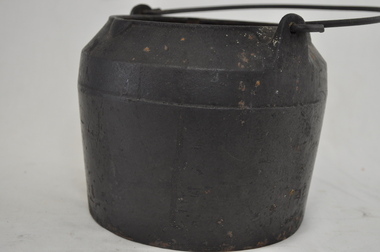
Before 1908 the words "melting pot" was a term relating to a "crucible" with a meaning of "a pot in which metals and other substances are melted (fused) to provide metal items of varying shapes and uses. From the mid 1900's this term changed and became more related to the "mixing" of social and ethnically diverse populations. The description used here is that of pre 1908. This melting pot was used in the early to late 1900's when produce and hardware shops were too far away from the Kiewa Valley and time was at the essence. The ability to manufacture as many "crucial " items at the home property was the difference between running a successful rural business or not. The isolation of the Kiewa Valley (before the 1950's), hindered the "time down" of machinery and important "widget" replacements. The ability of self sufficiency on properties is still a boon to rural properties as time lost is never really recovered.This melting pot is highly significant to the Kiewa Valley as it provides evidence that the graziers and cattle stations required to be self sufficient in all aspects of day to day maintenance and replenishment of worn materials requiring to be "manufactured " at the property and lack of replacements from commercially shelved products. This aspect of "survival" in the "bush" can be seen in the "huts" built on the Bogong High Plains to accommodate the seasonal grazing of cattle from the Kiewa Valley.This black melting pot is made of cast iron. The lid is missing. The top rim of the pot has three lips for poring accuracy. The formation of these lips are in a "triangle" formation. The top section of the body has a curve inwards reducing the pot diameter from 270mm at the base to 135mm.at the top. The handle is made from heavy gauge wire which is fastened to the body through two lugs (welded onto the top section of the pot) and fasten through a hole at the top of each lug. The handle has a "U" shape as it goes through the lug hole, ensuring no accidental fixture to any side thus allowing free swiveling from one side to the other . "BH" indented within a diamond shape. Opposite "No 3"camp fire cooking utensils, hot plate, cast iron cooking appliance, drovers kitchen -
 Kiewa Valley Historical Society
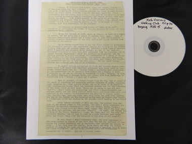
Diary Extract - Trip to Bogong High Plains Xmas 1934 & DVD photos, original diary 1934
... & cattlemen, the huts, the gauges set up by the State Electricity ...The Melbourne Women's Walking Club enjoyed bush walking as a hobby travelling to the north east of Victoria, using pack horses and camping on a 9 day hike. One of the woman, 'Bill' describes each day in detail - what they did, where they went and what they saw giving an insight into walking and the Bogong High Plains in the mid 1930's before the Kiewa Hydro Electric Scheme opened up the area. The diary mentions a photo being taken by Mr Blackwell on the 9th day, New Year's Eve 'from a lovely bush track from which, looking back at intervals we got our final glimpse of Fainter. 5 miles from from our destination'.Historic: This extract from the diary of 'Bill', a member of the Melbourne Women's Walking Club gives an insight into walking in the mid 1930's and describes the Bogong High Plains as it was then before it was opened up with a road built during the Kiewa Hydro Electric Scheme. It describes the area in summer including the flora & fauna, cattle grazing & cattlemen, the huts, the gauges set up by the State Electricity Commission of Victoria, the people working up there, the weather and the lifestyle of the walking group - their food, duties, swimming etc.. Six double sided typed photocopied yellow pages describing the Melbourne Women's Walking Club trip to the Bogong High Plains at Christmas in 1934. Also one page photocopied of the programme for Year 1934-35 with an arrow pointing to the above trip and a page with a photocopied sepia photo of the "Melbourne Women's Walking Club / Bogong High Plains / Dec. 1934. DVD 12 photos of the trip arrow showing trip from Programme. Title of photo "Melbourne Women's Walking Club / Bogong High Plains / Dec. 1934melbourne women's walking club. bogong high plains. camping. pack horses. cattlemen's huts. -
 Kiewa Valley Historical Society
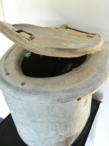
Toilet - Portable
This portable 'dunny' toilet may have been taken on camping trips possibly to the Bogong High Plains where this type of facility didn't exist.Cattlemen grazed their cattle on the Bogong High Plains during summer. They stayed in huts which had basic amenities such as a fireplace, tree stumps for seats and an area set aside for a bed. A separate area was used to stock firewood and the hut was located near a stream. Toilet amenities were most often in the bush.Dirty dented hollow tin cylinder with open ends top and bottom. It has a curved seat attached to the cylinder and a cover attached to the seat by a hinge at the back. It is hand made with basic fittings and is light to lift.Top of lid: "Guaranteed not / to use too much / water / Lifetime guarantee / on all parts / Bush Plumbing Co. camping. camping equipment. portable toilet. cattlemen. bogong high plains. -
 Kiewa Valley Historical Society
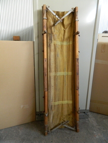
Stretcher - canvas x2
Canvas stretchers were portable and easily carried by pack horses. They were more luxurious than a hard wooden bed or the ground. Canvas was the best material to use at the time. This canvas stretcher may have been used on camping trips or by the cattlemen when visiting their huts on the Bogong High Plains.Used as a stretcher or camp bed and is very heavy. It is made of wood and 4 pieces of canvas sewn together. It has sides of elongated cubed wood with 4 handle extensions which are also cubed wood partly carved out near their ends for a more comfortable grip. The top has canvas attached to the wooden sides. The bottom has wood attached including the handles and a piece in the middle. Also attached are 4 steel rollers. A nail sticks out and stops the handles from going any further than the rollers. 4 metal strips are also attached for guidance of the sliding handles. 2 metal flat rods are attached to the sides at each end and joined in the middle by hinged nail enabling movement creating a metal strip at right angles to the length of the stretcher. The metal handles are attached here too. stretcher. bogong high plains. camping. sleeping. -
 Eltham District Historical Society Inc
Photograph - Black and White Print, Lewis Tulk, Original Training Hut, Gillwell Park, Gembrook, Vic, c.1960
Gilwell Park is a campsite and outdoor recreation area located in Gembrook, Victoria, Australia. It is primarily used by the scouting community as a training and camping facility. The site is owned and operated by Scouts Victoria, and is one of the largest and most popular campsites in the state. It covers over 95 hectares of natural bushland, and features a range of facilities including campsites, activity areas, a dining hall, and accommodation options. Gilwell Park has a long history within the scouting movement, and is named after the original Gilwell Park located in Epping Forest, England. The English site is considered the spiritual home of scouting, and was where the first Wood Badge training course was held in 1919. Today, Gilwell Park at Gembrook offers a range of training courses and programs for scouts, leaders, and other community groups. It is also a popular destination for school camps, corporate team-building events, and outdoor enthusiasts looking to explore the natural beauty of the region. [Source: ChatGPT Open AI - Gilwell Park in Australia.. (2023, March 23). Retrieved from https://chat.openai.com/chat] Donated by Lewis Tulk, former Scout Area Training Commisioner for Leaders. Lewis did his training at Gillwell Park in London.On reverse of print, stamped with film no. 6927scouts victoria, gillwell park, gembrook, scout leader training, lewis tulk collection -
 Eltham District Historical Society Inc
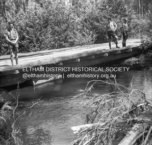
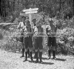
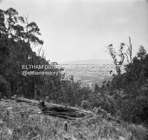
Photograph - Negative, Lewis Tulk, Scouting activities near Kinglake, Vic, c.May 1957
The Scouts used to set up camp at an old timber site near Tommys HutPrint copy stamped "17" on reverselewis tulk collection, kinglake, scout leader training, scouts victoria, tommys hut, timber mill -
 Eltham District Historical Society Inc
Photograph - Negative, Lewis Tulk, Scouting activities near Kinglake, Vic, c.May 1957
The Scouts used to set up camp at an old timber site near Tommys HutPrint copy stamped "17" on reverselewis tulk collection, kinglake, scout leader training, scouts victoria, tommys hut, timber mill -
 Bendigo Military Museum
Uniform - SLIDE SHOULDER BOARD
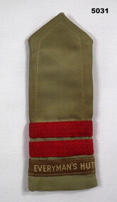
Established during world War Two, the first 'Everyman's Hut' was built at Bonegilla camp to serve army personnel. An 'Everywoman's Hut' was established at Bandianna and was staffed by women. The hut's were also staffed by ministers of religion who had returned to Australia due to war plus volunteers. Everyman's staff wore a military cut uniform and, where appropriate, were given officer status by local commanders. Today, Everyman's Welfare Service caters for the well being of members of the ADF and their families. Part of the Reverend Chaplain Major Thomas Bruce Williams, No556101, Collection.Khaki coloured slide should backgrounder board in poly ester fabric. A label with fawn lettering on a brown background is sewn to the straight end of the board. Above the label are two horizontal red bands in cotton braid.Embroidered on a brown label: 'EVERYMAN'S HUT'.everyman's hut, major thomas b. williams -
 Lara RSL Sub Branch
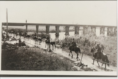
Photograph, Set 4 photographs. and others for Torquay Light Horse camp, 1940
These images capture for all time Light Horsemen travelling through Geelong on their way to camp at Torquay for the last Group meeting in Australia . information following - details obtained from .........https://torquayhistory.com/light-horse-brigade/ On Australia Day, 1997, Sir John Young unveiled this plaque on Point Danger, Torquay. Torquay history, Light Horse Training Camp, WW2 Plaque at Pt. Danger Note----- (See images to view plaque) The plaque identifies a significant event in Torquay’s history and the sentiments of ‘change’ for the Light Horse Brigade – from horses to machines. In 1940 the four Light Horse Regiments (4th, 8th, 13th and 20th), some 5000 Light Horse and 2000 horses camped and trained at Torquay. Three other regiments, formerly mounted on horses, were also at Torquay ‘mounted’ on privately owned trucks and cars. Division troops included Artillery, Engineers, Signals, Field Ambulance and other branches of the Army necessary to enable a Division to function. It wasn’t just the sheer numbers of men coming to this little town that made the event significant, it was also the fact that the men of the Light Horse were dramatic, almost glamorous figures and it is easy to see their exploits as some splendid adventure. Horses have played a special role in the story of Australia. They were the only means of transport across this huge country, so it was necessary for everyone to have the ability to ride a horse. When war broke out in 1899 between Britain and the Boers of South Africa (“Boer” was Dutch for “farmer”) Australia sent troops to fight. At first Britain was wary of using untried, unprofessional colonial cavalrymen but soon saw that the slouch-hatted Australian “bushmen” were a match for the fast-moving and unconventional mounted commandos of the Boers. The Australians proved themselves to be expert rough-riding horsemen and good shots. Bush life had hardened them to go for long periods with little food and water. They also showed remarkable ability to find their way in a strange country and use its features for cover, in both attack and defence. By 1914, when Australia joined the war against Germany, there were 23 Light Horse regiments of militia volunteers. Many men from these units joined the Light Horse regiments of the Australian Imperial Force (AIF). Men were given remounts (if not using their own horses) – army horses bought by Commonwealth purchasing officers from graziers and breeders. These were called “walers” because they were a New South Wales stockhorse type – strong, great-hearted animals with the strains of the thoroughbred and semi-draught to give them speed, strength and stamina. On 1st November, 1914, Australia’s First Infantry Division and the first four Light Horse regiments sailed for England in a fleet of transport ships. The first of the Light Horse arrived at Gallipoli in May without their horses. Back with their horses after Gallipoli, they were formidable combatants across the Sinai and Palestine. Some British commanders observed that the light horseman moved with a “lazy, slouching gait, like that of a sleepy tiger” but described how the promise of battle “changes that careless gait, into a live athletic swing that takes him over the ground much quicker than other troops”. They had Light Horse, Torquay, training campdeveloped a reputation as formidable infantrymen. The Turks called them “the White Ghurkas” – a reference to their deadly skill with the bayonet. The Arabs called them “The Kings of the Feathers”. The plume had originally been a battle honour of the Queensland Mounted Infantry for their work in the shearer’s strike of 1891. During WW1 it was adopted by almost all the Light Horse Regiments. It was the proud badge of the light horseman. The most famous of their battles was the attack on Beersheba- the charge of the 4th Light Horse Brigade. Mounted infantrymen and their superb walers had carried out one of the most successful cavalry charges in history – against what seemed impossible odds. They surprised the Turks by charging cavalry-style, when they would normally have ridden close to an objective then dismounted to fight. The fall of Beersheba swung the battle tide against the Turks in Palestine; and changed the history of the Middle East. While 19 men from the Surf Coast Shire served with the 4th Light Horse over the course of WW1, only four were involved in the charge of Beersheba- John GAYLARD, Philip QUINN.(Winchelsea); Wallace FINDLAY (Anglesea); Harry TRIGG (Bambra). After the war, Light Horse units played a key role in the Australian Government’s compulsory military training programme. The Citizen Military Forces (C.M.F.) thrived on the glamour of the wartime Light Horse tradition, ignoring the possibility that motor vehicles would soon replace the horses. When training was no longer compulsory, the C.M.F. regiments declined and horses became more of a luxury during the 1930s depression years of poverty and unemployment. Some regiments were motorised. Then, in 1939, Australia joined Britain in another world war. Training was increased for the militia at both home bases and regional training camps. The camp at Torquay in 1940, commanded by Major General Rankin, was at Divisional strength. By the end of the camp some felt that the Division was ready for active service. Gradually, over the next four years, the Australian Light Horse units were mounted on wheels and tracks and the horses were retired. Six men enlisted at the Torquay camp and another 57 men and women enlisted at Torquay for service in WW2. Those who served in the Militia provided valuable Officers and NCOs and men for the armed services during the war. Each infantry division of the 2nd AIF had a Light Horse regiment attached to it. But the day of the Australian mounted soldier hadn’t quite passed. During World War II, Australia’s 6th Cavalry Regiment formed a mounted unit they called “The Kelly Gang” which did valuable scouting work. In New Guinea, a mounted Light Horse Troop did patrol duty and helped carry supplies. Some fully equipped walers were flown into Borneo for reconnaissance in rugged mountain country. But by the end of the war, in 1945, the horse had disappeared from the Australian Army. References: Australian Light Horse Association www.lighthorse.org.au National Australia Archives Australian War Memorial Surf Coast Shire WW1 memorials www.togethertheyserved.com The Light horse- a Cavalry under Canvas Light Horse, Training Camp, Torquay, WW2 Late in 1939 it was decided to set up a Lighthorse training camp in Torquay to train both men and horses for the battles of the Second World War. Horses, men and equipment came on special trains from all over Victoria and NSW, and as you would expect horseman came from areas such as Omeo and Sale, the Wimmera and the Western District. They arrived at the Geelong racecourse for watering in the Barwon River and then were ridden across the ford at the breakwater and began their 11 mile trek to Torquay. Light Horse, Training Camp, Torquay, WW2 Tent city By the end of January 1940 the camp at Torquay accommodated some 5000 men and 2500 horses of the Second Cavalry Division. The rows of horses, tents and huts near Blackgate Road were quite a sight. While the cavalrymen engaged in exercises on the land and on the beaches, many of the troops took over the Torquay School for special training of men and officers. Mr Bob Pettit local farmer and Councillor for the Barrabool Shire, wrote about the Light horse in the Surf Coast Community News in 1985 saying “They used to travel about the district riding four abreast in one long convoy. To my annoyance they went through my property and shut all the gates behind them. I had certain gates open to let stock in to the water holes and it would take me three -quarters of an hour to follow the horsemen up and put all the gates right again” he continued “the men from the Light Horse were here when the fire went through in March 1940. He recalled an incident when early one morning, as some one blew the bugle, a soldier putting a white sheet on the line frightened the horses. They panicked and ran off in all directions. Six went over the cliff near Bird Rock, five were never found, and the rest were gathered up after nearly a fortnight in the bush around Addiscott and Anglesea" Light Horse, Training Camp, Torquay, WW2, Geelong Parade Geelong parade The training camp culminated in a parade through the streets of Geelong on March 12th 1940. The salute was given at the Town Hall and the troops continued on a route to the You Yang’s for a training exercise. Note-----(see media section for photograph) The Camp was abandoned in mid 1940 as it was deemed unsuitable for training during winter and the cost of a permanent camp could not be justified if it could not be used all year. Historic.......Rare,,,Interpretive.Sepia photographs.set of four ....post card size ....Horses &LighthorsemenNo 1, Lighthorsemen Regiment Geelong 1940......No 2 Light Horse at Breakwater Geelong 1938 to 1940....No 3 Light Horse at Breakwater Geelong 1938 to 1940.....No 4 Light Horse crossing Breakwater camped at Geelong Showgrounds. These markings are on reverse of photographs.light horsemengeelong 1940., world war 2 -
 Lara RSL Sub Branch
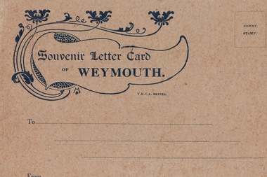
Postcards Booklet, Souvenir Letter Card of Weymouth
... Hut - Australian Base Camp... of the Weymouth area including the YMCA Hut - Australian Base Camp ...Following the landing of Australian & New Zealand troops, the Anzacs, at Gallipoli on 25th April 1915, casualties mounted rapidly and were initially transported to their base in Egypt, which was soon unable to cope, with wounded being sent to England. Here the troops found that there was no Australian base to which they could report once they had been discharged from hospital; what was needed urgently was a base in England where troops could be sent to convalesce. So on 31st May 1915 a command depot was set up at Monte Video House in Chickerell, some two miles from Weymouth. Weymouth then became the Australian Imperial Forces (AIF) Command Depot No.2 which accommodated those men not expected to be fit for duty within six months, therefore, most of the Diggers repatriated as a result of wounds or sickness passed through Weymouth. During the years 1915-1919 over 120,000 Australian and New Zealand troops passed through Weymouth. In Spring & Summer, Weymouth Esplanade would be full of Anzac soldiers in wheelchairs, being wheeled along by their more able mates. The first contingent of 200 wounded men arrived in the first week of June 1915, and two weeks later a group of local ladies organised a cream tea for the newcomers, followed by a concert party 'The Frolics' at the camp. So began the close connection that was to grow between the soldiers and the villagers of Chickerell. The ANZAC Memorial on Weymouth seafront commemorates the Australian and New Zealand troops who were accommodated in three camps in the town during WW1: Monte Video, Westham and Littlemoor. In Weymouth and Melcombe Regis Cemetery there are about eighty-six graves of those Anzacs who were never to return to their homelands. Also in memory of these troops, there a number of roads close to the camps named after Australian cities and states.A World War 1 Letter Card sent home by Australian troops repatriated in Weymouth, UK containing images of Weymouth and a picture of the Australian Base Camp.Front cover (see image) Souvenir Letter Card of Weymouth Inside are eight pictures of the Weymouth area including the YMCA Hut - Australian Base Campymca, uk, australian base camp, world war 1, ww1, aif, army, australian army, westham, littemoor, weymouth, melcombe regis cemetery, anzac -
 Bendigo Military Museum
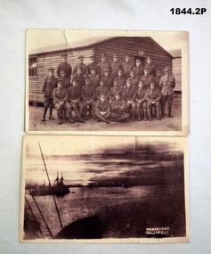
Postcard - PHOTOGRAPHS WW1, C.WW1
“Roy” is Roy Leslie Thurlow No 2493 AIF, KIA. Refer 1890P for his service history. Bovington Camp is in England..1) Photo shows a group of 28 Soldiers outside of hut No C18 The original card was written on. .2) Image shows ships in the bay. In white in the corner are the words "Moonlight Gallipoli" .1) “To Claude from Roy, we had this taken at Bovington Camp”photography - photographs, post cards -
 Phillip Island and District Historical Society Inc.
Photograph - Photographs of Phillip Island, 1920s and 1940s
Photographs associated with Public Schools camp, that started in the 1930s. Some boys worked on chicory at McFee's farm. 314-05 was possibly located at Trenavin Farm, Ventnor. (Source Jan Andrews ) Photo of people on cart with tank stand was off to a 7 picnic at the Nobbies 1917. [See 1124-01] Keeston Sambell driving, behind him is Betty Parker. on side from left is May Lambert, Jim Patterson, Jim Blake, Carmen Sambell and Bill Sambell.[ Source Jim Blake] Eight black & white photographs. 314-01. Photograph of horse and cart with 2 women, 2 girls and 5 boys. 314-02. Photograph of a mixed group of 7 people on a horse and drag. 314-03. Photograph of 3 young adult males and a dog standing in front of a wooden building. 1926 “Campers Rest” Labelled The Immortal camp at Ventnor. Poss. Trenavin Park 314-04. Photograph of 5 boys and 1 woman swimming in rock pool. 1 boy watching. 314-05. Photograph of old wooden hut with tank and chimney. Appears to have been used by boys when camping. 314-06. Photograph of 4 boys - 2 in swimming costumes - on the beach. 314-07. Photograph of 3 women and 1 girl sitting on sand dunes. 314-08. Photograph of 3 boys in uniform and 1 man sitting on bench - maybe watching sporting event?scotch college camp phillip island, scotch college boys, s j mcfee, c.k. newman, f. r. newman, trenavin park phillip island, sambell family, jim blake, betty parker -
 Phillip Island and District Historical Society Inc.
Photographs, Kodak, Early 20th Century to mid 20th Century
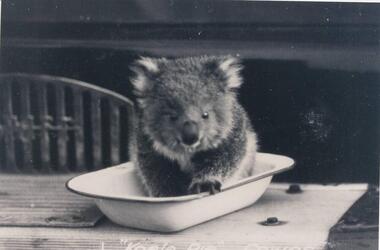
... westernport the two bridges san remo mutton bird eggers camp steam ...A collection of a group of photographs donated to the Society by Lun Blom, from the Photo Shop in Thompson Avenue, Cowes (was opposite the museum)A collection of 19 photographs of Phillip Island and surrounds. 293-01. Koala sitting in enamel bowl on table 293-02. 20 farmers having a break. 293-03. Reproduction of painting of The Nobbies. 293-04. Photograph of a Trophy for 1st prize for ploughing won by Mr L Morrison 1859. 293-05. Photograph of three men standing in front of a motor vehicle. 293-06. Photograph of view of Cleeland's House at Cape Woolamai. 293-07. Photograph of a whale beached on Phillip Island with people standing around it. 293-08. Photograph of a family and children in front of car - unknown. 293-09. Photograph of a painting of "Innishowen" Harbison's Property. Mr Harbison's portrait inset on the painting. 293-10. Photograph of an early map - possibly drawn by Bass & Flinders. 293-11. Photograph of the San Remo-Westernport Hotel, with vehicles in front. 293-12. Photograph of a fishing boat at the San Remo Jetty with the township in the background. 293-13. Photograph of a couta boat under full sail in Westernport. 293-14. Photograph of an aerial view of the Two Bridges taken from San Remo side. 293-15. Photograph of the Mutton Bird Eggers Camp - Bergins Bay Cape Woolamai. 293-16. Photograph of a Steam ferry decorated with flags. 293-17. Photograph of Fisherman's hut at Cowes with pier in the background. Possibly Mr Cox's. 293-18. Photograph of a couple standing on the bridge in Lover's Walk Cowes. 293-19. Photograph of an aerial view of Phillip Island looking towards Mornington Peninsula and the Heads to Port Phillip Bay in the distance.293-01. "Koala Pie" Cowes. 293-06. Mr Cleeland's Station. 293-09. "Innishowen" Mr. Harbison. 293-10. Phillip Island. 293-17. Phillip Island - Fisherman's Hut, Cowes. 293-18. Phillip Island - Lover's Walk, Cowes.wildlife - koala, wildlife - whale, the nobbies, ploughing trophy, cape woolamai - cleeland's house, innishowen, mr harbison, phillip island map, westernport hotel san remo, fishing boat san remo pier, couta boat westernport, the two bridges san remo, mutton bird eggers camp, steam ferry, fisherman's hut cowes, lover's walk cowes, aerial view of phillip island, lyn blom -
 Lorne Historical Society
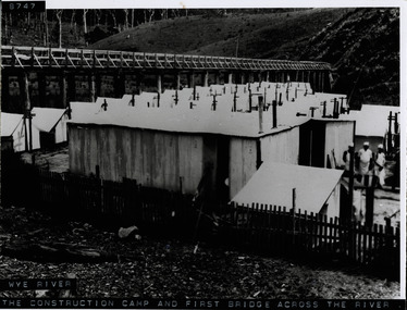
Photograph, Workers camp at Wye River Great Ocean Road
Photograph showing wooden bridge across Wye River, with workmen's camp below. Shows galvanized iron sheds, cooks standing outside huts, tents. Denuded hillside and dead trees. -
 Greensborough Historical Society
Photograph - Digital Image, Children playing at Greensborough and District Poultry Co-op, 1950c
Children playing outside Greensborough and District Poultry Co-op. Photograph from the collection of Elaine Drakeford (nee Roberts). [Refer to Frye Family for more Co-Op details]. This building was sited in the Watsonia Army Camp (hence the building looks like an old army hut).Digital copy of black and white photograph.elaine drakeford, greensborough poultry co op, poultry farm -
 Halls Gap & Grampians Historical Society
Photograph - Coloured
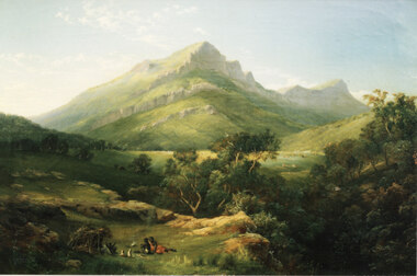
This is a photo of a painting by Nicholas Chevalier (1828-1902). The painting is "Mt Abrupt, Grampians", circa 1864, oil on canvas, 46.0 x 61.0 cm (held in a private collection, London).This is a photo of a painting. It shows a stylised view of a mountain with a further peak behind it. The front of the peaks have high, rock cliffs. In the foreground there is an aboriginal camp, including a shelter with two people sitting in it, two people and two dogs sitting outside on the grass and a camp fire between them and the hut.painting, landscape -
 4th/19th Prince of Wales's Light Horse Regiment Unit History Room
Booklet, Camouflage Military Training Pamphlet No 46 Part 3 Huts Camps and Installations 1944, April 1944
... Part 3 Huts Camps and Installations 1944 Booklet ...Soft covered booklet detailing the camouflage of camps, installations and dumps outside the effective range of enemy artillery. Restricted Supersedes the 1942 editioncamouflage, world war 2, -
 Kiewa Valley Historical Society
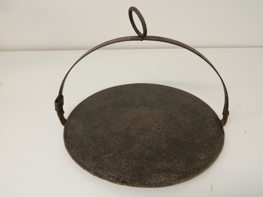
Plate Hot - Camp Fire, circa early 1900s
This "camp fire" hot plate has been used from the early 1900's on camp drafts /droving cattle onto and from the Victorian high plains. The size of "camp" kitchens would depend on the amount of "cattle" men required to collect and move the "herd" to and from the "lush" high plains.This "camp fire" hot plate is significant because it was donated by a member of the Roper family (the Roper's of the Kiewa Valley) a "pioneer" family. This particular camp fire hot plate originated in Tasmania however the Victorian Alps are very similar to the Tasmanian mountain regions and this type of cooking utensil was, and still is, used in isolated regions e.g. large cattle properties in the Northern Territory. This Camp Fire hot plate was used on the High Plains at the Roper Hut for approximately 35 years.This open fire hot plate is made from caste iron. It has a circular flat (cooking) base, ideal for a few thick pieces of prime steak, a high semi circular handle with a large circular carry ring, to apply a thick stick or rod through it as an insulated handle (to position the hot plate where required over a fire). The "handle" can be folded down to save space when packing it in the saddle bags. The handle has a strong metal rivet on each end (is loose enough to allow it to be moved to either side e.g. flattened). One end, of the handle, has a movable sleeve to fasten the the handle in an upright positioncamp fire cooking utensils, hot plate, cast iron cooking appliance, drovers kitchen, cattlemen -
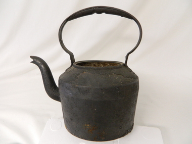 Kiewa Valley Historical Society
Kettle Cast Iron, Circa 1950
This kettle was used by pioneer families, mainly rural, folk that needed a constant readily available source of boiling water, in or mainly outside the homestead.. This kettle was used in the early to late 1900's for the refreshment of stock men and farmers that had irregular "tea" breaks under sometimes hard and gruelling conditions.This kettle belonged and was used by a Kiewa Valley, pioneer family, the Roper Family. This kettle was moved from their Kiewa Valley property to their hut built on the Bogong High Plains. A scientific study started in 1947 to study the impact of grazing cattle on the natural Alpine and sub Alpine vegetation found grazing cattle had an adverse affect on the natural Alpine and sub alpine vegetation, and grazing on the plains was stopped by the Victorian Government in 2005.This "camp draft" could take up to six weeks.This large cast iron kettle holds a capacity of three pints of water/tea. It has a flat base and mushroom shaped handle welded onto the "pot" below the rim of the pot opening. It has a rim to position the tea pot lid but no lid. It has a curved spout "welded" to the main body.Clark Qualitycamp fire cooking utensils, hot plate, cast iron cooking appliance, drovers kitchen -
 Kiewa Valley Historical Society
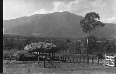
Black and white photograph of Surveyor's Camp, 1938, Kiewa River and surveyor's Camp 25/8/38, 25/08/1938
Surveying under the prevailing conditions at this time was an arduous and demanding task. There were no roads beyond Tawonga and access was by bridle tracks, on foot or horseback. This camp was to provide accommodation to those men who were surveying the road from South Tawonga to the Bogong High Plains which was commenced in April, 1938. The actual work was undertaken by the Country Roads Board, on behalf of the State Electricity Commission, using three Caterpillar diesel crawler tractors equipped with Kay Bruneriei (Brunner) lhydraulically operated trailbuilders (angle dozers)This photograph shows the primitive living conditions that were endured by those carrying out the initial field investigations and surveys for the Kiewa Hydro Electric Scheme. It is possibly one of the few photographs in existence of this camp and of the very rustic timber foot bridge across the West Kiewa river. It has been taken from approx. 100m up Simmonds Creek Road. A black and white photograph showing a small, timber foot bridge across the West Kiewa River. There is a man standing on the bridge and two small huts on the far side of the river, against a backdrop of Mt. Beauty and Mt. Bogong.At the top of the photograph, handwritten in black ink is the inscription "Kiewa River and Surveyor's Camp 25/8/38". The number 4 is stamped towards the right upper corner. On the back, in a circle, about 1.3cm in diameter, are the words "Kodak Print". The word "Velox" is faintly discernible on the back as well.surveyor, tawonga, west kiewa river, bridge, camp, secv -
 Kiewa Valley Historical Society
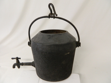
Pot Large with Tap, Circa 1950
This type of cast iron kettle was used by pioneer families, mainly rural in the early 1900's upon open fires (log). It covered rural activities that needed a constant readily available source of boiling water, in or mainly outside the kitchen of homesteads. This kettle was used in the early to late 1900's for the refreshment of stock men and farmers that had irregular "tea" breaks under sometimes hard and gruelling conditions.This kettle belonged to and was used by a Kiewa Valley, pioneer family, the Roper Family. This kettle was moved from their Kiewa Valley property to their hut built on the Bogong High Plains. The Bogong High Plains area provided Kiewa Valley cattlemen a good supply of fodder to supplement their Kiewa Valley grazing areas. This "camp draft" activity , in the high plains, could take up to six weeks.This large cast iron modified camp pot (cauldron) has a long tap connection located at the bottom end. The "tap" is made from brass and has a simple elongated "bar" control swivel at the end to control the water flow. The tap suggests that only water was heated (to a constant boil) for the replenishment of cattlemen's, or other horse rider's, tea or coffee mugs. Refreshments at a "temporary" location on the Bogong High Plains. There was a "log" hut built by the Roper family as temporary accommodation for cattlemen and other family members.Ot the flat bottom "FIRST QUALITY 2 GALLONS"camp fire cooking utensils, hot plate, cast iron cooking appliance, drovers kitchen -
 Kiewa Valley Historical Society
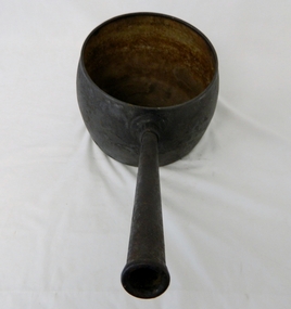
Saucepan, circa mid to late 1900's
This large deep pan (with a long handle) was used by pioneer families, mainly rural folk, that needed a pan which could cope with an open fire heat source, in or mainly outside the homestead. This pan was used in the early to late 1900's for the "stews" and other meals required by hard working stock men and farmers that had irregular "lunch and dinner" breaks under sometimes hard and gruelling conditions. Hot plates were normally not in use.This "open fire" saucepan belonged, and was used by a Kiewa Valley, pioneer family, the Roper Family. This saucepan was moved from their Kiewa Valley property to their hut built on the Bogong High Plains. This saucepan was one of an array of "open fire" cooking utensils used in the "camp draft" grazing in the Bogong High Plains and this could take up to six weeks. This kettle belonged and was used by a Kiewa Valley, pioneer family, the Roper Family. This kettle was moved from their Kiewa Valley property to their hut built on the Bogong High Plains. A scientific study started in 1947 to study the impact of grazing cattle on the natural Alpine and sub Alpine vegetation found grazing cattle had an adverse affect on the natural Alpine and sub alpine vegetation, and grazing on the plains was stopped by the Victorian Government in 2005.This large (black, soot infused) cast iron saucepan has a "ten pint" holding capacity and was used on the "open fire", possible on the fire direct. It has a long all metal handle coming from the top half of the pot and angled at approximately sixty degrees upwards. This angle insures that both distance from flame intensity and least bending of knees when lifting is at a minimum.On bottom of pan (underside) "N0. 8 JSJ SIDDONS" on the other side "WEST BROMWICH 5 QUARTS"camp fire cooking utensils, hot plate, cast iron cooking appliance, drovers kitchen -
 Kiewa Valley Historical Society
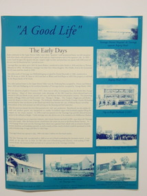
Posters - 9 in the Set, The Famous Bogong School, Beyond the Gate-(up and down) , A Good Life, The Precursors, Great Expectations, Windows to Yesterday, c1998
These posters were produced for a display during the Mt Beauty Music Festival in 1998. They cover the history of the Kiewa Valley from the early days, farming and the Kiewa Hydro Electric Scheme. These posters summarise the history of the Kiewa Valley and were compiled using memories, publications and documents. The posters are clear and useful for display.Large glossy cardboard posters: Mostly blue and white with photos and writing of the history of different aspects of the Kiewa Valley 1. Bogong School 2. Bogong Village 3. Mt Beauty 4. Tawonga 5. The Early Years 6. Kiewa Hydro Story 7. The Kiewa Valley Runs 8 & 9. Cattlemen & Huts of High Plains. Created for display with sources sighted. See KVHS 0956 bogong state school. bogong village. state electricity commission of victoria. tawonga. surveyors. mt beauty. camps. kiewa hydro electric scheme. kiewa valley. -
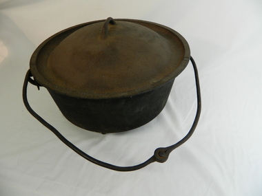 Kiewa Valley Historical Society
Pot Lid - Cast Iron
... bogong high plains. cattlemen. camp oven. cooking. roper's... plains. cattlemen. camp oven. cooking. roper's hut. Albion ...Cattlemen used cooking pots when on the High Plains.Used by the Cattlemen on the Bogong High Plains at Roper's Hut.This cast iron lid fits the cast iron pot. It has a handle (cast iron) on top. The lid is domed. The outer 1 cm edge is flat. Inside this edge the lid dips 2 cms before rising into the dome.Albion / No. 15 / Maryboroughbogong high plains. cattlemen. camp oven. cooking. roper's hut.