Showing 314 items
matching industrial building
-
 Eltham District Historical Society Inc
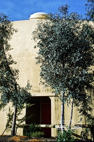
Photograph, Fred Mitchell, Bini Shell at Diamond Creek, 1983, 1983
In 1978 Diamond Valley Shire recognised the need for a new public hall in Diamond Creek. Council considered the Bini shell form of construction which was in operation overseas and in use in New South Wales as libraries, gymnasiums, sports centres and multi-purpose centres. The Council gave the go-ahead. A site was chosen opposite the Hotel and close to the railway line. One day in - the following year, in 1979, activity stood still in Diamond Creek as school children and other excited spectators watched the one-hour inflation of the Bini Shell. This unusual method of construction was invented by Italian industrial designer and architect Dante Bini. The construction pneumatically raises a level of reinforced concrete from ground level which has not been set, using an internal balloon. The inner membrane inflates and compresses the mesh and concrete against the outer membrane. A net of flexible steel rods was laid on the building’s circular base, on the top of a fabric bladder. 300 tonnes of reinforced concrete were poured onto the mesh and a sealed cover laid over the concrete making a sandwich of cover, bladder and mesh. Compressed air was pumped into the bladder and the sandwich slowly began to rise and become a massive self-supporting dome. After inflation and removal of the outer membrane workmen filled in any holes. It was some days before pneumatic drills pecked out the first opening. The ceiling of the concrete dome was lined with fluffy insulating material. The dome was 36 metres in diameter at the base and 12 metres high in the centre with a usable floor space of 670 square metres. An opening night dinner was held to celebrate the new facility on March 12, 1980. Shire President Ron Pata made a speech and unveiled a plaque. It was the first public building in Victoria to be erected using the Bini Shell design method of construction The facility could cater for up to 400 people and in 1980 a fee for use was $100 for up to 200 people, $150 for up to 300 people and $200 for up to 400 people. For the next ten years or so, locals attended the hall for marital arts classes, basketball and netball games and school discoes and various other activities. After pieces of concrete fell off a Bini shell interstate due to a construction fault, the Council closed the centre. Demotion took place during the Diamond Creek Town Fair in 1991, as part of the annual Town Fair’s program. Research by LP January 2022This was the first public building in Victoria to be erected using the Bini Shell design method of construction.Digital copy of colour photographfred mitchell collection, 1983, bini shell, diamond creek -
 Glen Eira Historical Society
Book - Chisholm Institute of Technology
Chisholm Institute of Technology’s Faculty of Technology Magazine, Feedback, No.3 1989. 1988 Prospectus of Chisholm Institute of Technology Official Invitation to opening of Continuity and Change, dated November 1985. Chisholm Institute of Technology Planning Brief (draft copy) dated 1985. Includes architectural drafts of campus. Fourteen pages including Building Plans. Official invitation to staff and students’ exhibition at Chisholm Institute of Technology 1983. Chisholm Institute of Technology Conferring of Awards booklet dated May 20, 1983. Includes list of graduates, staff and council. With handwritten notes on rear end pages. Undated brochure of advertising courses offered at Chisholm Institute of Technology. Loose card inside with description At Chisholm You’ll Get More Than Just A Piece Of Paper. Includes campus plans. Chisholm Institute of Technology Open Day brochure dated 1982. Includes map at back.vaughan geoffrey n. dr., jakovidis greg, mcleod ian, mckenry keith, chisholm caroline, jones b.o. hon., coogan c. k. dr., green k.d., aboriginal medicine, solar, engineering, applied physics, prospectus, chisholm history, school of art and design, david syme business school, school of education, school of nursing, school of social and behavioural studies, faculty of technology, centre for applied mathematical modelling, centre for business technology, centre for industrial tribology, centre for development of entrepreneurs, chisholm timber engineering technology centre, international business centre, polymer research centre, building plans, building construction, invitations, caulfield plaza, princes avenue, railway avenue, queens avenue, caulfield station, derby road, caulfield east, dandenong road, caulfield, chisholm institute of technology, caulfield campus, frankston campus, education, tertiary education -
 Glen Eira Historical Society
Article - Caulfield Institute of Technology
Four items about the establishment,history and courses provided at this Institute: 1/Research notes (2 pages in all) regarding the renaming of Caulfield Technical School to Caulfield Institute of Technology in 1968 sourced from La Trobe Library Reference Index. Several dates listed. Reference also to article on construction of building in 'Australian Builder' of January 1950. 2/Photocopy of article from 'The Australian Accountant', April 1975. Gives history of C.I.T. and of Business School courses plus photos. (3 pages) 3/Advertising flyer for 'The David Syme Business School at CIT' listing courses for enrolment by 15/12/1978. 4/Undated black and white photograph of building in progress on site of Caulfield Institute/Monash University Caulfield. Noted on reverse'Chisholm Tower', 'Contact June 29, PIC 3 PG3 100% pl2' ie likely taken by photographer for 'Caulfield Contact'.miller j.o. mr. (b.a. b. com. f.a.s.a.), huggan noel, halstead h.j. mr., kurtz david professor, holmes graham, collins mike, chataway graham, erdonmez hassan, gleeson june, voumard lou, coombe jack, caulfield technical college, caulfield technical school, caulfield institute of technology (cit), k.h. boykett building, monash university, dandenong road, caulfield east, victorian education department, school of business, school of applied sciences, school of engineering, school of industrial studies, school of general studies (humanities sociology art and design), technical schools, technical colleges, education, secondary education, mature age students, david syme business school, 'contact' -
 Federation University Historical Collection
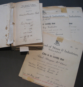
Book - Certificate stub book, School of Mines Ballarat, Ballarat School of Mines Certificate Stubb Book, 1938-1964
This certificate stub book contains the subject certificates of the graduates of the School of Mines and Indutsries, Ballarat, a predecessor of Federation University Australia.This item highlights the subjects studied and graduates of the School of Mines between 1938 to 1964. It also records the change of cursive over that time.This book includes stubs of subject certificates from the School of Mines and Industries, Ballarat. This also contains a number of uncollected certificates. It is a brown hardback book with black binding. Its contents covers certificates between 1938 to 1964. Names of recipients include: Charles Holt, Henry Elford, Irvin Singleton, J. H. Hughes, John Morcom, Alfred Amor, John Wastell, John Rudwick, Jared Hines, Harry Allan, L. F. J. Hillman, Arthur Davies, Letitia Stanley, Victor Wright,Raymond Ball, Mary O'Callaghan, Ethna Burke, Alec Foyster, James Duggan, Leonard Auchettl, Reeves Collins, James Patterson, Stanley Douglas Webb, Oswald Lyle, Marvis Orr, Eric Roberts, Jack Clennell, A. R. Millar, Heith Smyth, Walter Hines, Harold Leslie, Joseph Fisher, Geoffry Burns, Alick Dait, George Hill, Raymond Wines, Robert Manson, Albert O'Neill, Thomas Green, William Stargatt, William Harrison, Reginald Allen, Albert Wilson, Allan Curtis, Arthur Donald, John Wynn, Sydney Robinson, John Blackic, Percy Elsdon, Hubert Jenkins, Kingsley Callister, Douglas Hall, Norman Lawson, Winfield Tonkin, Artuhur Williams, Allan Curtis, Ernest, Billinge, John Daelon, Harold Bunting, Stanley Wilton, Robert Sugden, Heith Foster, Winsome Stevens, Herbert Stanbridge, Robert Pittard, Henry Brew, Ernest Berriman, Carlyle West-Onley, William Blackic, Lorna Dunstan, Cedric Pike, Stanley Jephson, Hugh Hendrick, Joseph Fisher, Ernest Grove, Ronald Fisher, Heith Halsall, Henry Harris, Maxwell Silvey, Stanley Trengove, Donald Trescowthick, Harold Tolliday, Russell Lucas, John Boyd, John Keys, Stanley Betteridge, Ernest Betteridge, Michael Ross, Robert Stewart, Joseph Beasley, William Beasley, Ray Deveson, George Hennessy, Charles Matthews, Maxwell Silvey, Ian Creek, Geoffrey Moorhouse, Hector Tonks, John Donald, Hugh Hendrick, Stanley Jephson, Ian McIntosh, Robert Nice, Ralph Scott, Walter Martin, Grant Coutts, Lindsay Hannah, John Tainsh, Hubert Robinson, John Donald, George Beaton, Heather Harris, Brian McCarthy, Samuel Perry, Valentine Pascoe, Philip McLean, Geoffrey Hewish, Hubert Robinson, John Borch, Frederick Gale, Ian Grundell, Albert Perry, Frank Hutchinson, Horace Shuttleworth, Kenneth Mason, David Hatt, Malcom Foster, George Jones, Graham McKinnon, Ronald Newton, John Betts, Leonard Wade, Robert McClure, David Beaumont, Leslie Powell, Samuel Perry, Donald Treweek, Edgar McArthur, Russell Fraser, Edgar McArthur Bartrop, Clive Carmichael, Leslie Fuhrmeister, Lindsay Coon, Zigurds Plavina, Victor Gingell, Rupert McKenna, Graham McKinnon, David Fairley, Johannes Meennen, Ronald Murphy, Johannes Naus, John McConville, Graham Melonie, William Cutter, Thomas Chalkley, Kenneth Morton, Stanley Shears, Robert Auld, Donald Campbell, John Cofield, Brian Whykes, William Milford, Noel Richards, Stewart Jacobs, James Robertson, Clement Rose, Eric Brown, Allan Raworth, Ernest Salter, Neville Cartledge, Peter Stacey, Robert McClure, Antonius Goossens, Rodney Cartledge, Rodney Hayes, Bevan Grigsby, James Robertson, Neil Stephens, John Riddle, Andreas Aaus, Bruce Fletcher, Keith Pedler, Allen Flavell, Robert Cartledge, Ronald Shaw, Kenneth Hibberd, William Lockland, Percival Bilney and Petrus Damen. Uncollected certificates for James Patterson, Robert Sugden, Ernest Berriman, Stanley Jephson, Henry Harris, Maxwell Silvey, Joseph Beasley, Charles Matthews, Maxwell Silvey, Ian Creek, Geoffrey Hewish, Robert McClure, Kingsley Callister, Winfield Tonkin, Raymond Wines, Oswald Wilde and Kenneth Mason are included within. The subjects covered include: Printing, mining, geology, metallurgy, mining geology, mine surveying, mechanics applied to mining, electric welding, machine shop practice, algebra, trigonometry, mechanics and heat, applied mechanics, heat treatment, graphics, oxywelding, engineering drawing, blacksmithing, shorthand theory advanced, shorthand speed, commercial English, intermediate English, plain dressmaking, dressmaking advanced, electric wiring, physics, electric technology, carpentry, machine shop, plumbing, trade science, carpentry and joinery, building construction, heat treatment, wiring, oxyacetylene welding, foremanship, turning and fitting, electric wiring, arithmetic, social studies, commercial correspondence, office routine, bookkeeping, typewriting, shorthand, electric refrigerator servicing, refrigeration, radio mechanics, trade maths, sheetmetal, wool sorting, motor mechanics, human relations in management and industrial supervision. Many of the stubbs are signed by principal Dick Richards. Each certificate is signed by the current principal of the School of Mines and Industries, Ballarat, and a number have also been signed by the students.school of mines, school of mines andindustries, certificate, richard w. richards, horace william shuttleworth, dick richards, charles holt, henry elford, irvin singleton, j. h. hughes, john morcom, alfred amor, john wastell, john rudwick, jared hines, harry allan, l. f. j. hillman, arthur davies, letitia stanley, victor wright, raymond ball, mary o'callaghan, ethna burke, alec foyster, james duggan, leonard auchettl, reeves collins, james patterson, stanley douglas webb, oswald lyle, marvis orr, eric roberts, jack clennell, a. r. millar, heith smyth, walter hines, harold leslie, joseph fisher, geoffry burns, alick dait, george hill, raymond wines, robert manson, albert o'neill, thomas green, william stargatt, william harrison, reginald allen, albert wilson, allan curtis, arthur donald, john wynn, sydney robinson, john blackic, percy elsdon, hubert jenkins, kingsley callister, douglas hall, norman lawson, winfield tonkin, artuhur williams, allan curtis, ernest billinge, john daelon, harold bunting, stanley wilton, robert sugden, winsome stevens, herbert stanbridge, robert pittard, henry bre, ernest berriman, carlyle west-onley, william blackic, lorna dunstan, cedric pike, stanley jephson, hugh hendrick, joseph fisher, ernest grove, ronald fisher, heith halsall, henry harris, maxwell silvey, stanley trengove, donald trescowthick, harold tolliday, russell lucas, john boyd, john keys, stanley betteridge, ernest betteridge, michael ross, robert stewart, joseph beasley, william beasley, ray deveson, george hennessy, charles matthews, maxwell silvey, ian creek, geoffrey moorhouse, hector tonks, john donald, hugh hendrick, stanley jephson, ian mcintosh, robert nice, ralph scott, walter martin, grant coutts, lindsay hannah, john tainsh, hubert robinson, john donald, george beaton, heather harris, brian mccarthy, samuel perry, valentine pascoe, philip mclean, geoffrey hewish, hubert robinson, john borch, frederick gale, ian grundell, albert perry, frank hutchinson, horace shuttleworth, kenneth mason, david hatt, malcom foster, george jones, graham mckinnon, ronald newton, john betts, leonard wade, robert mcclure, david beaumont, leslie powell, samuel perry, donald treweek, edgar mcarthur, russell fraser, edgar mcarthur bartrop, clive carmichael, leslie fuhrmeister, lindsay coon, zigurds plavina, zig plavina, victor gingell, rupert mckenna, graham mckinnon, david fairley, johannes meennen, ronald murphy, johannes naus, john mcconville, graham melonie, william cutter, thomas chalkley, kenneth morton, stanley shears, robert auld, donald campbell, john cofield, brian whykes, william milford, noel richards, stewart jacobs, james robertson, clement rose, eric brown, allan raworth, ernest salter, neville cartledge, peter stacey, robert mcclure, antonius goossens, rodney cartledge, rodney hayes, bevan grigsby, james robertson, neil stephens, john riddle, andreas aaus, bruce fletcher, keith pedler, allen flavell, robert cartledge, ronald shaw, kenneth hibberd, william lockland, percival bilney, petrus damen, james patterson, robert sugden, ernest berriman, stanley jephson, henry harris, maxwell silvey, joseph beasley, charles matthews, maxwell silvey, ian creek, geoffrey hewish, robert mcclure, kingsley callister, winfield tonkin, raymond wines, oswald wilde, kenneth mason, trades -
 Federation University Historical Collection
Booklet, The Ballarat School of Mines and Industries 1870-1920 Jubilee Booklet, 1920 (estimated)
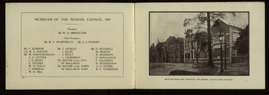
The first school of Mines in Australia was established at Ballarat in 1870. At the time of its jubilee (1930) the following people were members of the School Council: W.H. Middleton (President), W.T. Humphreys (VP), J.S. Vickery (VP), F. Barrow, Col. W.K. Bolton, William Baragwanath, A.E. Cutter, J.N. Dunn, G. Fitches, W.H. Fleay, F. Herman. W.D. Hill, T. Hurley, K. Kean. J. Kelly, L. Lederman, Mayor of Ballarat, Mayour of Ballarat East, D. Maxwell, M. Martin, R. Maddern, D. Ronaldson, F. Saunders, R. Stephenson, A.O. Stubbs, R.E. Tunbridge. The School Staff in 1920 comprised: Herbert H. Smith, Walter Rowbotham, Reginald L. Cutter, M.C. Young, Hilda Wardle, M. Wiliamson, P.S. Richards, L.H. Archibald, J. Woods, Ken Moss, W. Kenneth, Mrs McIlvena. B. Robinson, S. Rowe, E. Hope-Jones, Miss Abrams, L.St.G.P. Austin, Alfred Mica Smith, J.R. Pound, Herbert R. Murphy, N.H. Junner, Maurice Copland, L.H. Archibald, E.J.A. McConnon, Newton King, D.m. Hull, T.R. Gordon, John M. Sutherland, T.K. Jebb, Dick Richards, C. Tonkin, A.W. Steane, J. Paterson, H.W. Malin, R.V. Maddison, S.M. Mayo, F.A. King, W.H. Steane, T.R. Gordon, T.A. Williams, H. Waldron, G. Black, E.J. McConnon, R.V. Duncan. R. Cutter, E.G. Vawdrey, Hilda WardleWhite stapled booklet - landscape format - 20pp + soft covers with blue writing. Includes an historical sketch of the Ballarat School of Mines. Contains images of the school from around 1920. The history outlined in the booklet follows: 'Ballarat has helped to influence the life and destinies of Australia in many ways, the recital of which would perhaps prove tedious to the citizens of less favoured localities! However, it can be said, without much fear of contradiction, that only less known thought Australia than its fame as a gold field is the reputation won for it by its school of Mines, ... Ballarat was still quite a new place when the School was founded, but a very propserous and popular place all the same, with a go-ahead lot of citizens brim full of the spirit of enterprise which seemsto animate mining populations generally. Money was plentiful, and they launched out into ventures, which later, were to develop and take the place of the gold mines, while what is more to the point, they understood the value of education. the old digging days were passing away. So far as Ballarat itself was concerned the day of the cradle and tin dish had already passed into an antiquity "as dead and distant as the age of the Tubal Caon," said dir redmond Barry on declaring the School open. Mining had become a serious business, and the mining engineer, the metallurgist, and the geologist had become a power in the land. In these circumstances the suggestions to found a School of Mines met with ready acceptance. The late Mr James M. Bickett had the honor of bringing forward the proposition at a meeting of the Ballarat Mining Board in October, 1869. it was agreed to, and the Government, having been approached for assistance, granted a lease of the old Supreme Court buildings at a nominal reantal. A modest sum, including 100 pounds from the Borough Council of Ballarat West, was subscribed by a number of sympathisers, and on the 26th October, 1870, the inaugural address was delivered by Sir Redmond Barry, the first President of the School. Classes were commenced on the 23rd January, 1871. The students at first were mostly adults. They were chiefly men emloyed at the mines, who had the wisdom and energy to devote their spare time to study, and, though their attendance was somewhat irregular, they made very good progress. Old prints which have been preserved show them at work at furnaces, big bearded men of the old-fashioned type of miner. It is interesting to note that among those who gave evidence and encouragement was Sir Roderick Murchison, who many years before had advised Cornish miners to emigrate to Australia to search for gold, and who in 1848 was in possession of gold ore sent from this country. Sir Roderick sent a parcel of books for the library, and gave useful advice as to the curriculum which should be adopted. The Museum, which now contains a most valuable collection of minerals, was one of the first things attended to, and the reports presented to the Council from time to time speak of additions being made from all parts of the world. New equipment was constantly being added to the School, a good deal of assay work was done, and some specimens were sent from the East Indies for examination as far back as 1873. By this time there was a difficulty in providing accomodation for the students who wished to enrol, and the number of instructors had grown from two to four. In 1882 the first building was being erected on what was then part of the gaol reserve. A little more than ten years afterwards a buildnig formerly serving as a Methodist Church was absorbed, while later on, the demand for accomodation increasing, the attack upon the gaol was renewed. The School continued to grow in reputation and size, and became the science centre of the district, and in 1889 a learge new building was opened by Sir Alexander Peacock. Students came from over seas as well as from all the States of Australia, and after going through their courses they took with them the name and fame of the old School to all parts of the globe. School of Mines boys have played a great part in developing the mining fields of Western Australia, South Australia, and africa, while old students who have made a name in their profession are constantly dropping in to see how the old place is getting along. It was not to be expected, however, that the Ballarat School would be left without rivals, its very success inspiring competition. Mining Schools were started in other parts of Australia, and, at the same time, Victoria ceased to hold first place as a mining state. On the other hand there was a great advance in manufacturing, and the demand for technicaly trained men became a great and as insistent as ever it had been for trained mining men. The Council was quick to adapt the school to the new conditions, and the result is seen in the institution, which is one of Ballarat's proudest possession. Instruction is given in all branches of technical work, and the classes are filled with students who are building up for Ballarat a reputation as an industrial centre, which promises to equal that which it formerly held as a mining town. Owing to its bracing climate, its abundant opportunities for recreations, and its accessibilty, Ballarat as a city is an ideal place for educational purposed, and is yearly becoming more and more appreciated throughout the State. The chairman of one of Ballarat's biggests industries claims that the workman can do twice the day's work here that he can do in Melbourne. he was a little enthusiastic over it, perhaps, but it is a well-known fact that the healthy and invigourating Ballarat climate is conducive to both physical and mental activity, and the records of the School provide ample proof of it. One of the most interesting and successful branches of the School of Mines and Industries - if the name be enlarged with the enlargement of its scope - is the Technical Art School. "The City of Statues" has from its earliest days been a stronghold of art. Art schools have flourised here, and in 1905 the Education Department came to the conclusion that the best thing to do with them was to place them under the management of the School of Mines Council. A magnificent new Technical Art School was built at a cost of some 12,000 pounds on the site of the old Supreme Court building, and was formally opened on the 23rd July, 1915. The results have not only been justified but surpassed all anticipations. The most comprehensive list of subjects is taught, and this list is constantly added to. Students have flocked to the art School, which may be said to occupy a unique position in Australia, and its record of success is really astonishing. Its students supply art teachers for the newer schools that are being built, and many occupy leading positinos in important business houses. So well is its reputation known that orders are constantly being received, not only from Victoria, but from other States, for honor boards and challenge shields to be designed and made. The most recent addition to the School of Mines and Industries is the Junior Technical School, for which a new building is now being erected on a portion of the gaol site, transferred to the School of Mines Counci by the Government. At the present moment temporary quarters are being occupied. Some students after passing through the Junior School go straight to employment, continuing perhaps to attend the evening trade classes, while others move on to the senior School. In a review of the work of the School of Mines mention must be made of a series of industrial research carried out under supervision of the Principal. One in particular, regarding the suitability of the local ores for the manufacture of pigments attracted much attention, while the experiemtns on the manufacture of white potery from Victorian clayes were considered of sufficient importance by the Federal Advisory Council of Science and Industry to warrant the appointment of a special investigator. The results of these have been most encouraging, and may have far-reaching consequences. The vocational training of returned soldiers also should not be overlooked. The work was taken in hand from the first, before the Repatriation Department gave assistance, and now with the help of the department of the School has become one of the largest vocational training centres in Victoria outside of Melbourne. The soldiers, trained in a variety of occupations, have made remarkable progress, and already considerable numbers have found employment in local workshops and factories. To sum up, the School is divided into the following departments, each well staffed and equipped: - The School of Mines, science, and Engineering; the Techncial Art School, the Boys' Junior Technical School, the Girl's Preparatory Technical Classes, Trade Classes, and the Commercial School. The school of Mines, science and Engineering, comprises the following branches: - Mining, Metallurgy, Geology, Electrical Engineering, Civil Engineering, Mechanical Engineering, Applied Chemistry, and Pharmacy. Battery treatments, Cyanide Testing, Smelting, Assays, and Clay Testing from a regular part of the School's work. Students gaining qualifications obtain concession in their courses at the university, should they proceed there to continue their studies. The technical Art school curriculum includes training in all branches of pictorial and applied art, an Architectural Diploma Course, a Draughtman's Course, technical Art teachers' Course, Photography,Ticket Writing, Art Metal Work, Woodcarving, Needlework, and Leather work. The Trade Classes give instruction in Telephone Mechanics, telegraphy, Carpentry, Cabinet Making, Plumbing, Blacksmithing, Fitting, Electric Wiring, and Printing. Numerous Scholarships are offered every year, and altogether students will find few places to equal the Ballarat School of Mines and Industries as a training place for their life's work. One of the first in the continent to be established, its Jubilee finds it still in the front rank, keeping pace with the times, and offering to the youths of this country the means of taking advantage of Australia's teeming opportunities. william, battery, smith, herbert, drawing from the antique, ballarat school of mines botanical gardens, ballarat school of mines, redmond barry, alfred mica smith, james bickett, museum, dick richards, ballarat junior technical school, s m b, ballarat school of mines and industries, ballarat technical art school, model mine, james m bickett, j m bickett, roderick murchison, vocational training rooms, wesley church, methodist church, alexander peacock, lathes, repatriation, repatriatin department, war service, school council, baragwanath, gold mining, mining laboratory, plaster cast, r.w. richards, anniversary, jubilee -
 Federation University Historical Collection
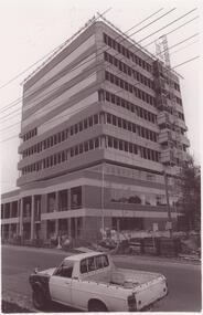
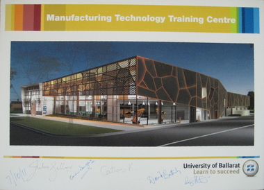
Photograph - Poster, University of Ballarat Manufacturing Technology Training Centre poster signed by Prime Minister Julia Gillard, 07/10/2011 (approx 11.15am)
The new Manufacturing Technology Training Centre (MTTC), a part of the proposed Building Construction Training Centre (BCTC), will be a purpose-built, stand-alone, fully fitted-out industry-standard facility. This new space will accommodate current course provision along with specialist training spaces for developing skill requirements in manufacturing technology such as robotics, mechatronics, engineering and industrial automation. Project funding was provided by the Education Investment Fund from the Australian Government Department of Education, Employment and Workplace Relations. The project budget is $18.09m, and the resulting building will have a floor space of 4,755m2. The Manufacturing Technology Training Centre is being built in conjunction with the Technical Education Centre (UBTec). While the buildings will have separate street identities the buildings will be joined with shared amenities areas. UBTec will provide a facility including individual learning spaces, learning studios, administration/office space, circulation, open plan learning space, staff common areas, computer rooms, meeting rooms, staff work areas and kitchen areas as well as car parking and site-wide amenities. While the buildings will have separate street identities the buildings will be joined with shared amenities areas. Funding for the UBTec component of the building is provided by Maintaining the Advantage: Skilled Victorians from the Victorian State Government. A colour poster prepared for the 'turning of the sod' at the site of the proposed University of Ballarat Manufacturing Technology Training Centre (MTTC), Grant Street, Ballarat. The poster was signed on Friday 7 October 2011 at about 11:15 am at the Building Construction Training Centre (BCTC), Grant Street, Ballarat by: Hon. Julia Gillard MP Hon. Catherine King MP (Ballarat ) Prof. David Battersby, Vice Chancellor, University of Ballarat Mayor, Cr Craig Fletcher, Mayor of the City of Ballarat appointed in December 2010 Mrs. Karen Douglas, Chair University of Ballarat Building & Infrastructure Committee The poster is signed by the Prime Minister of Australia, the Hon. Julia Gillard MP; Karen Douglas; the Hon. Catherine King MP (Ballarat ); Prof. David Battersby (Vice Chancellor); Craig Fletcher (Mayor, City of Ballarat)university of ballarat, david battersby, julia gillard, prime minister, catherine king, ubtec, karen douglas, manufacturing technology training centre, grant street, architecural feature -
Federation University Historical Collection
Booklet, Ballarat School of Mines Prospectus A and B, 1916-7, c1917
The Ballarat Technical Art School was part of the Ballarat School of Mines.1) Ballarat School of Mines Prospectus A .2) Ballarat School of Mines Prospectus B Contents includes teaching staff, school hours, curriculum, fee list, Travelling concessions, school library, classification of subjects. scholarships, Full art and Craft Courses (Industrial Design; Figure, Modelling, Painting and Design; Figure Drawing, Modelling, Painting and Design; Fashion Plate Drawing; Black and White Illustration; Modelling; Wood Carving and Lettering; Art Metal Work; Retouching, colouring, &c; Architectural Diploma; Draughtsmen's Courses; Art Teachers' Courses; Outdoor Sketching Classes; Photography; Building Construction and Architectural Drawing; Ticketwriting; Signwriting and Decorating COurse; Dressmaking, Needlework, etc; Preparatory Technical Classes for Girls; Day Commercial Classes; Other Branches of the School's Activities, examination results; Art Teachers' Certificate. Includes an image of W.H. Middleton, President of the Ballarat School of Mines; Staff of the Ballarat School of Minesballarat school of mines, ballarat technical art school, design, modelling, figure drawing, fashion plate drawing, black and white illustration, wood carving, lettering, art metal work, retouching, architecture, architectural diploma, draughtsmen's courses, art teachers' courses, outdoor sketching classes, photography, building construction, architectural drawing, ticketwriting, signwriting and decorating, dressmaking, needlework, art teachers' certificate. -
 Flagstaff Hill Maritime Museum and Village
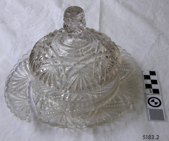
Domestic object - Butter Dish
The art of making glass can be traced back to 2600 BC in Mesopotamia. Egyptians practised making glass around 2500 BC. Artificial glass first appeared in the Egyptian or the Mesopotamian civilization, whereas they used tools made out of volcanic glass obsidian in the Stone Age. Ancient China, however, discovered how to make glass a little later. Glass beads are known to be one of the earliest products made out of glass. Their creation is thought to be primarily accidental. In the later Bronze Age, glassmaking came to a halt. Glass was a luxury material back then. Archaeological excavations suggest the use of glass in England during the middle ages. In the 10th century, stained glass found a place in cathedrals and windows of palaces. After the Renaissance, architectural methods changed substantially, leading to a decrease in stained glass as a building material. Domestic use of glass increased following the industrial revolution. Vessels, glass windows, and glass beads gained popularity in Europe during this period. During the 19th century, many people preferred glass windows and doors as a decorative option. In the late 19th century, some designers brought back stained glass in decorative windows. It was during this period that Mr Tiffany discovered several methods to make domed glass handicrafts. People discovered the true versatility of using glass as a building material only in the 20th century. With glassmaking technology receiving an industrial boom, you could produce several different types of glass. Toughened glass, laminated glass, bulletproof glass, and smart glass all boosted the use of glass in buildings. Today, several skyscrapers, small and big homes, and offices use glass in almost all aspects of construction and design. https://www.aisglass.com/glass-made-step-step-process/The invention and development of glass, both as domestic items and in building, has been nothing short of revolutionary. Prior to the use of glass for windows, the interior of buildings were extremely dark, even during sunny days. The use of glass domestic objects, that could be easily washed, led to improved hygiene.Moulded patterned glass butter dish. Base has been broken.None.flagstaff hill, warrnambool, shipwrecked-coast, flagstaff-hill, flagstaff-hill-maritime-museum, maritime-museum, shipwreck-coast, flagstaff-hill-maritime-village, glass, kitchen item, butter -
 Flagstaff Hill Maritime Museum and Village
Document - Framed Poster, Borough of Warrnambool, Victoria, Australia, after 30/06/1875
This document, also referred to as a word picture or Tablet, is framed in glass and timber with gilt trim, is handwritten with colour highlights. The penned letters rest on ruled guide lines, decorated where the lines intersect. The writing gives a description of the state of Borough of Warrnambool around 1875; its location, the area it covers, its population, Harbour and facilities, public buildings and institutions, imports and exports, financial worth, number of houses, connection with other areas of the Colony. A possible reason and origin for the document is found in an article ‘Link with US Exhibition’ from the Warrnambool Standard of December 19, 1981, written by local historian Bruce Morris. The writer mentions that the Warrnambool Borough Council met on 15th June 1875 and recorded a letter from G.C. Levey , secretary to the Melbourne group of commissioners representing the Colony, and Victoria in particular, for the Philadelphia Centennial Exhibition of 1876. The letter asks Council to provide “statistics as to the population, social condition and commercial and industrial state of the district in and around Warrnambool.” A sub committee was formed for the project. The Mayor, Cr. Thomas King, wrote and signed a Report, presented to the council on July 14, 1875, in which “The Committee … begs to recommend that a Tablet be prepared setting for the particulars respecting the following matters relating to the Borough”. The matters included area, population, annual income, churches, schools, other public buildings, societies and companies, general description of houses erected, and returns of exports and imports for 1874. The minutes note that the Report was adopted. The article above also notes the opinion of Warrnambool printers who have examined the document; it is almost certainly to be an old lithograph, which means there could be several copies. It is possible that there may be a copy in Melbourne and another in Philadelphia. It is interesting to note that (1) the quoted location co-ordinates are for an “Unnamed Road, Packsaddle NSW 2880, Australia”, and that the DMS co-ordinates for Warrnambool’s Council Offices differ, being 38.23.9.12 South, 142.28.52.887. (2) the date for “Exports and Imports for the Year Ending 30th June 1875” is different to the period mentioned by Cr. King in the sub committee’s Report of recommendation “returns of exports and imports for 1874”. The information required to have the figures for the end of June 1875 would need to have been compiled very quickly for the Tablet to be ready for the opening of the Philadelphia Exhibition on 10 May 1876. The document/certificate shows the following – - - - - - - - - - - - - - - -- - - - - - - - - - - - - - -- - - - - - - - - - - - - - -- - - - - - - - - - - - - - - “Victoria Australia, Borough of Warrnambool. Latitude, 30.24.50 South, Longitude 142.32 East The Principal Port in the Western District of the Colony and the Centre of its Choicest Agricultural Lands. Established a Municipality in 1855, and Created a Borough 1863. Population in 1875 4,500. Warrnambool is the nearest Port to Melbourne on the Western Seaboard, being about 160 miles distant. Coaches run to and from the Metropolis daily, in connexion [connection] with the Railway of Geelong and Steamers belonging to Local Companies sail between Melbourne, Warrnambool, Belfast [renamed Port Fairy], and Portland several times weekly. The Harbour is known as Lady Bay, and is partially protected by a reef of rocks stretching from the mouth of the Hopkins River. The formation of a Breakwater has been decided upon by the Government, to extend 600 yards, at an estimated cost of £100,000. There are two substantial Jetties, one of 800 and the other of 600 feet in length. The former is connected with the Town by means of a Tramroad, along which Goods, inwards & outwards, are conveyed, & the latter has been constructed solely for the purpose of facilitating the transit of material for the formation of the Breakwater. In addition to the trade of the Borough and District, the principal Townships up country receive their supplies from Melbourne and ship their exports through Warrnambool. Potatoes form the staple produce of the district, and the richness of the soil can be estimated by the fact that the Government Statistics for 1875 give as the average yield a return of Seven Tons to the acre. Several thousand acres between Warrnambool and Tower Hill are now being laid down in Potatoes by Tenants who have leased the lands at rates up to £5 per acre for the season 1875-6. Wool, Tallow, hides &c are also largely exported, while the shipments of all descriptions of Farm Produce are annually increasing. Area of Borough, 3362 Acres. Net Annual Value £27,000. Annual Revenue £5,500. Number of Houses in Borough 800. Public Buildings and Institutions Churches. Church of England, Roman Catholic, Presbyterian, Wesleyan, Congregational and Baptist. Schools. Three State Schools, average attendance nearly 1000. New Building in course of erection. Several private establishments. Banks. Bank of Australasia, Bank of Victoria, National Bank, Colonial Bank and Savings Bank. Public Buildings. Court house, Custom house, Post & Telegraph Offices, Survey & Land Offices, Shire £, Town Hall, Mechanics Institute, Volunteer Orderly Room, Odd Fellows Hall, Hospital & Benevolent Asylum, Temperance Hall &c. Companies & Societies. Steam Navigation Co, Woolen Mill Co, Gas Co, Racing Club, Amateur Turf Club, Agricultural Society, Farmers’ Club, Cricket Club, Anglers’ Society, Building Society, Freemasons Odd Fellows, Foresters, Druids, Hibernians. Protestant Alliance, Rechabites, Sons of Temperance, &c, Fire Brigade &c. --- Exports and Imports for the Year Ending 30th June 1875 –-- --Exports Total Tonnage 27,800 (Calculated at the Current Warrnambool Market Prices) Potatoes Wool Wheat Barley Hides Skins Fowls Butter Cheese Eggs Tallow Leather Ale Pigs Sheep Sundries --Imports 13,000 Tons Of the Estimated Value of £520,000 Total Tonnage of Exports and Imports 40m900 Tons, Value £806,627 Passenger Travels, to ad from Warrnambool during year, 10,000 persons Revenue from all sources paid through Warrnambool Sub Treasury From 1860 to June 1875 £1, 292, 300 Thomas King [signed] Mayor Henry T Read [signed] Town Clerk” - - - - - - - - - - - - - - -- - - - - - - - - - - - - - -- - - - - - - - - - - - - - -- - - - - - - - - - - - - - - The document is of historical, social, economic and local significance in that it summarises activities, business, community, trade, travel and government at a point in time in Warrnambool’s history – 30th June 1875.Document, also referred to as a ‘word picture’ or ‘tablet’. Document is framed in glass and timber with gilt trim, handwritten with colour highlights. The penned letters rest on ruled guide lines, decorated where the lines intersect. Document outlines the establishment of Warrnambool as a Municipality in 1855 and Borough in 1863, with a population of 4,500 in 1875. It states geographic location, public buildings and institutions, harbor facilities and imports and exports for the year ending 30th June 1875. Two signatures "Thomas King" Mayor and "Henry T Read" Town Clerk. It shows the Coat of Arms of the Borough of Warrnambool.Signatures - "Thomas King" Mayor and "Henry T Read" Town Clerk. Warrnambool Coat of Arms; “British Coat of Arms, above sailing vessel and sheaf of wheat in sun, motto “By these we flourish” and around circumference “Borough of Warrnambool 1855”flagstaff hill, warrnambool, shipwrecked coast, flagstaff hill maritime museum, maritime museum, shipwreck coast, flagstaff hill maritime village, great ocean road, borough of warrnambool, municipality of warrnambool, document borough of warrnambool 1875, word picture of warrnambool 1875, tablet of borough of warrnambool 1875, statistics borough of warrnambool 1875, lithograph borough of warrnambool 1875, coat of arms warrnambool, warrnambool city motto – in these we flourish, establishment of warrnambool, warrnambool history, thomas king mayor of warrnambool, henry t read town clerk of warrnambool, warrnambool breakwater, warrnambool jetty, warrnambool imports and exports 1875, warrnambool agriculture 1875, warrnambool business 1875, warrnambool population 1875, centennial exhibition philadelphia 1876, framed certificate -
 Federation University Historical Collection
Book - Newsclippings, Folder of Newspaper Cuttings Relating to University of Ballarat and Federation University Australia, 2004 onwards, 2004 onwards
Folder of newsclippings, including: Ballarat Courier 03 November 1999 - Ballarat Sporting Heroes (Shayne Reese, Tony Lockett, Dennis Shaw, Tessa Molloy, Lisa Bruty, Kirst Benoit, Brett Hunter) Ballarat Courier 19 May 2001 - State revenue Office Ballarat Courier 02 MaY 2003 - Brian Howlett Kembla Lines September 2006 - Inside Steel at Port Kembla Weekend Australian 23-4 September 2006 - Adams Forges a Legacy in Steel by Robert Gottliebson - Bluescope Steel, Kirby Adams. Port Kembla Ballarat Courier 14 May 2003 - Alan Webb received Honorary Doctorate Ballarat Courier 07 July 2007 - Exhibition Showcases A Century of Artworks by Dorothy Wickham - outlines an exhibition highlighting 100 years of Art Lectures curated by Clare Gervasoni Ballarat Courier 23 December 2010 - Historical Sites Study Launched - Ballarat Industrial Heritage Wiki launched. Ballarat Courier 21 April 2014 - Unknown Soldier, tunnellers par of project's research: Wartime Connections Ballarat News 14 February 2019 - FedUni VC to speak at leadership forum. (Photo: Helen Bartlett) Ballarat News 10 June 2021 - Taking a closre look at contact tracing by Katie Martin. (Contact tracing during the Covid19 pandemic) Ballarat News 21 October 2021 - Hospital adds temporary Covid-19 triage tent by Edwina Williamsfederation university, university of ballarat, tony lockwood, alfred deakin place, state regional freight links program, nazareth house, ballarat technology park, state revenue office, wendouree parade, deer park bypass, geelong road caravan park, brian howlett, alan webb, honorary doctorate, arthur pickford, mosaics, john pickford, janet holmes a court, mount helen campus history, ballarat techncial art school, tony flude, joseph flude, humanities, nurture the humanities, clunes school of mines, ballarat school of mines 140th anniversary, david battesby, john mcdonald, kath white, catherine laffey, neil trivett, greg simmons, ballarat & district industrial heritage wiki, federation university art collection, ballarat school of mines honor book, clare gervasoni, henry sutton, sutton's music house, john smythe, david caro, david caro obituary, student union, new university name, merger, gippsland, mount helen campus, univesity of ballarat alumni connect, name change, science building, y building, ballarat equine centre, ballarat brewery, ballarat and united breweries, feduni, former ballarat gaol, ballarat gaol basement cells, federation college, sam henson, janet cowles, alexandra tascas, helen bartlett, graduation, pandemic, covid19, covid-19, corona virus -
Glenelg Shire Council Cultural Collection
Photograph - Photograph - Portland Harbour, 1960-1966
Port of Portland Authority archivesFront: (no inscriptions) Back: Valuable reclaimed industrial land alongside main shipping berths at Portland (typed on sticker, centre)port of portland archives, aerial photography, portland harbour -
 Glenelg Shire Council Cultural Collection
Photograph - Photograph - Portland Harbour, 1960-1966
Port of Portland Authority archivesFront: (no inscriptions) Back: (no inscriptions)port of portland archives -
 City of Moorabbin Historical Society (Operating the Box Cottage Museum)
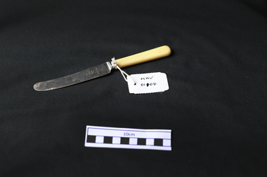
Kitchen Equipment, cutlery butter knife, c1930
Rodd's was established by George & Ernest Rodd in Melbourne in 1919.They were manufacturers and wholesalers of precious metal jewellery. Later they began to manufacture high quality silver plated cutlery under the brand name “Rodd”. They then expanded into holloware when they took over Platers Pty. Ltd. who produced a very high quality range of silver plated Sheffield Reproduction Silverware, under the brand name “Hecworth”. Rodd’s established a large factory at 150 Barkly St., St. Kilda, Melbourne. During WW2 with a staff some 200, the factory produced ordnance components to help with the war effort. Rodd’s established sales offices in the main city centres of all States. The company prospered. In December, 1960, Rodd [Australia] Ltd. was merged with Mytton’s Ltd., Melbourne, and became part of the newly formed company Mytton Rodd [Australia] Ltd. Mytton’s were also producers of silver plated cutlery under the brand name “Grosvenor” and were strong competitors to the Rodd brand of cutlery Australia wide. It was a friendly take over and the Directors of Rodd [Aust.] Ltd. were appointed to the board of Mytton Rodd [Aust.] Ltd., and some to the Holding Company Mytton’s Ltd. Mytton’s were heavy manufacturing engineers producing a large range of stainless steel products including: kitchen sinks of various design, beer barrels [9 and 18 gallon kegs] for the breweries, milk vats for cooling and storing milk on dairy farms, a large range of dairy and industrial vessels, road transport tanks, LPG tanks, low pressure pre-mix vessels for the soft drink industry. They also produced a range of domestic bathes, steel railway sleepers, using their 3000 ton hydraulic presses. Mytton’s also had their own non ferrous foundry and rolling mill which produced nickel silver sheet used in the manufacturer of their silver plated cutlery. They also produced copper sheet for their own and industrial use. Mytton’s had factories in York St., South Melbourne and Port Melbourne. Rodd [Aust.] Ltd. set up a manufacturing, distribution plant in Auckland, New Zealand, circa 1960. This company began producing precious metal jewellery in a rented space in the premises of Matthey Garret Ltd., Bullion Merchants, in Drake St., Auckland. Later they moved into their own building in Sale St., Auckland. The company prospered and purchased land and built a factory at 121 Apirana Ave. Glen Innes, Auckland, circa 1964. ( B. McCulloch Rodd Pty Ltd)A butter knife with stainless steel blade and bone handle c1930on blade; RODD / STAINLESScutlery, stainless steel, cheltenham, moorabbin, bentleigh, early settlers, rodd aust ltd, mytton rodd pty ltd, aukland, port melbourne -
 City of Moorabbin Historical Society (Operating the Box Cottage Museum)
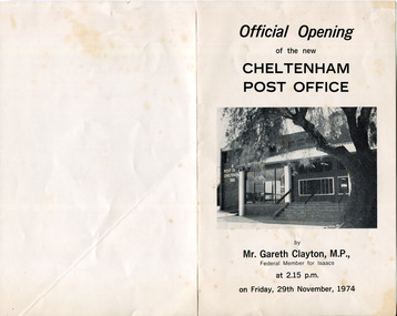
Document - Program Official Opening Cheltenham Post Office, Government Printer, 1974
John Hitchen was the manager of the first Cheltenham Post Office that opened 1/8/1857 in a boot and shoe store. Mail was transported to and from St Kilda to Cheltenham by coach 6 days a week and an additional service twice weekly to Tootgarook via Frankston also by coach. 1868 Post office Savings Bank began operation and the Telegraph office was established at the Railway Station 1885. A new building was built 1891 in Point Nepean Road for the official Cheltenham Post Office and a new manual telephone exchange began 1899 with 24 subscribers. By 1909 100 subscribers, 1951 there were 1700 and in 1974 12,000 subscribers . Hence this new building was designed by Oscar A. T. Gimsey & Assoc. and built by T W Morris & Sons Mordialloc. Mr G Clayton Federal MP Isaacs, opened the Post Office with Moorabbin City Council Mayor C.R McHutchison, Mr WJB Pollock, Director Posts and Telegraphs, and hands the Key of the post Office to Mr L De Longville Postmaster.The Post Office was an integral part to the development and prosperity of the Cheltenham area as the area grew from pioneer settlers in the 1850's to flourishing market gardens c1900 and industrial diversity of 1974.Program for the 'Official Opening of the Cheltenham Post Office' November 29th 1974 with a black and white photo of the building.city of moorabbin, county of bourke, moorabbin roads board, parish of moorabbin, shire of moorabbin, henry dendy's special survey 1841, were j.b., bent thomas, o'shannassy john, king richard, charman s, highett william, ormond francis, maynard dennis, post office, telegraph, st kilda station, tootgarook, frankston, clayton g mhr, mchutchison r.p mayor, pollock w j b mp, market gardens, early settlers, horse coach, de longville l postmaster -
 Bendigo Historical Society Inc.
Newspaper - JENNY FOLEY COLLECTION: CHARING CROSS
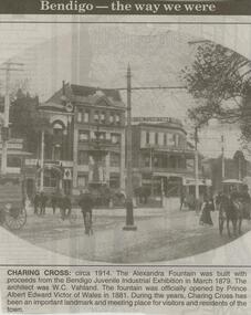
Bendigo Advertiser ''The way we were'' from 2000. Charing cross: circa 1914. The Alexandra Fountain was built with proceeds from the Bendigo Juvenile Industrial Exhibition in March 1879. The architect was W.C. Vahland. The fountain was officially opened by Prince Albert Edward Victor of Wales in 1881. During the years, Charing Cross has been an important landmark and meeting place for visitors and residents of the town. The clip is in a building.newspaper, bendigo advertiser, the way we were -
 Bendigo Historical Society Inc.
Photograph - DEEBLE'S PYRITIES WORKS, approx. 1950's
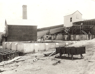
black and white photo - enlargement of industrial treatment works showing elevated building in background with two male adults. One by concrete vats at ground level, one on elevated landing. Container on trestles and timber in foreground. Weatherboard building by large concrete vat and acid ? Carboys at centre and left. Decorated brick chimneys ciovered race to upper building. On back in ink ? Foggit Jones? In grey lead Foggit Jones.organization, business, pyrites treatment plant -
 Bendigo Historical Society Inc.
Administrative record - Provisions Register 1897 - 1908
The Benevolent Asylum was established to provide both indoor and outdoor charitable relief for the destitute and aged. Initially it was in a slab and weatherboard building before getting it's permanent home in 1860. (Now Ann Caudle Centre). From 1868 - 1885 an industrial school for children was included. In 1884 a Lying in Hospital was included and this closed in 1920.Bendigo Benevolent Asylum Provisions Register 1897 - 1905. Green coloured marbled pattern cover with red and white tape on the spine with lined ledger pages. The ledger includes the provisions acquired and dispersed each day. All entries handwritten in ink. Standard supplies included with space to add special items.bendigo benevolent asylum, provisions register -
 Bendigo Historical Society Inc.
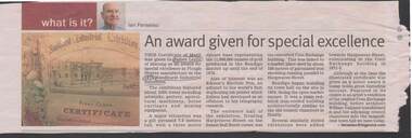
Document - CERTIFICATE OF MERIT: TO JAMES LESLIE
... PERSON Individual James Leslie Corn Exchange Building Sandhurst ...Certificate of Merit - to James Leslie for special excellence in Plough Shares manufacture, 1979 Sandhurst Industrial Exhibition. article by Ian Feneslau (Bendigo Advertiser/Miner - no date). Mention of engraving on Certificate of original Corn Exchange building.Ian Fenselau, Published by Bendigo Advertiser.person, individual, james leslie, corn exchange building, sandhurst industrial exhibition. plough shares manufacture. -
 Port Melbourne Historical & Preservation Society
Photograph - Gasworks, 1890s
Large sepia print, gasworks buildings with bottle works in foreground and gasometers in background, c1890sgasworks, built environment - industrial, bottle works -
Port Melbourne Historical & Preservation Society
Article - Deliverette van, 19 Mar 1987
The van was last registered in 1948, and forgotten when the factory began building Sabre jets. The van spent a number of years in Sir Lawrence's garage. It was rescued from local scrap metal dealers by Rosebus car dealer Barry Patterson.Newspaper article about Deliverette van which had a collapsible drivers seat instead of standing room only driving. The parcel van was designed and built by Sir Lawrence Hartnell in the early 1940s at the Commonwealth Aircraft Factory. Also a photocopy with the following notation "750 cc BMW engine on test bench at C.A.C. June 1941. Technician Rob Robinson, photographer Norm Robinson.built environment - industrial, transport - motor vehicles, sir lawrence hartnett, general motors-holden, gmh, ron robinson, norm robinson, commonwealth aircraft corporation, cac -
Port Melbourne Historical & Preservation Society
Photograph - Various buildings, Port Melbourne, Ron Laing, 1990s
Part of Ron Laing's collection of photographs recording Port Melbourne over a thirteen year period. Donated to the PMH&PS by the photographer.A set of 16 colour photographs by Ron Laing covering the Herald and Weekly Times building, the ex Borer's Bakery ovens and buildings, view from Coles parking area, Bridge Street industrial medical clinic and HMAS Lonsdale building 1990sbuilt environment - commercial, built environment - civic, ron laing -
Port Melbourne Historical & Preservation Society
Document - Agreement, Erect Emersol Plant at Ingles Street, Port Melbourne, J Kitchen & Sons Pty Ltd and H G White Pty Ltd, 1 Sep 1949
Pale green agreement between messrs J KItchen & Sons Pty Ltd & messrs H G White Pty Ltd to erect a new Emersol Plant Building at Ingles St, Port Melbourne. Schedule of conditions of building contract.No. 25944industry, manufacturing, built environment - industrial, j kitchen & sons pty ltd, h g white pty ltd, emersol, f oakley, c e serpell, c r hansen, louis thompson, charles henderson, alder & lacey, ingles street -
Port Melbourne Historical & Preservation Society
Document - Agreement, Erect single storey office building, J Kitchen & Sons Pty Ltd and Swanson Bros Pty Ltd, 17 Dec 1953
Pale green agreement between J Kitchen & sons Pty Ltd and Swanson Bros Pty Ltd of 663 Chapel St South Yarra to erect a single storey office building, Schedule of conditions of building contractNo. 56218industry - manufacturing, built environment - industrial, j kitchen & sons pty ltd, swanson brothers pty ltd, ingles street, harry a norris, p hall, d c swanson, l robinson, russell c stewart, r prentice -
Port Melbourne Historical & Preservation Society
Document - Agreement, Erect Edible Oils Department, J Kitchen & Sons Pty Ltd and H G White Pty Ltd, 14 Apr 1953
Faded green agreement between messrs J Kitchen & Sons Pty Ltd and messrs H G White Pty Ltd to erect and complete an Edible Oils Department. Schedule of conditions of building contract.No 48276industry - manufacturing, built environment - industrial, j kitchen & sons pty ltd, h g white pty ltd, ingles street, alders & lacey - architects and consulting engineers, w h gibbs, p webber, greenwood, p oakley, c e serpell, c r hausen, louis thompson -
Port Melbourne Historical & Preservation Society
Document - Chemicals for Industry, J Kitchen & Sons, 1960s
Kitchens. Blue covered ringbinder labelled "Chemicals for Industry". General information and sections on each product. Data sheets in each section give details of chemical makeup of each product and suggested applications. Early section called "the Kitchen Story" includes an aerial view photo with names of all buildings.industry, manufacturing, built environment - industrial, j kitchen & sons pty ltd, f g pott - managing director, unichema -
Port Melbourne Historical & Preservation Society
Booklet - Amenities Block, J Kitchen & Sons, Unilever Australia Pty Ltd, 1957
Nineteen page booklet with pale blue card cover (with drawing of Amenities Block) and brighter blue binding. The introduction states that the building is about to be completed and it is for all employees use. Written in 1957 it includes section headings - Progress of amenities, Port Melbourne; Design of the building ; Dining and canteen facilities ; Locker and toilet facilities ; Medical centre ; Entrance and time clocks ; Personnel Department ; Social Club library ; Conference room ; Vehicles; Changes in the use ofbuildings ; Use of the building; and drawing of the layout of each floor.industry - manufacturing, business and traders - soaps/candles, built environment - industrial, workers, unilever australia (holdings) ltd, j kitchen & sons pty ltd -
 Port Melbourne Historical & Preservation Society
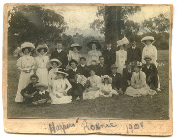
Photograph - Robert Harper & Co picnic, 1908
Robert Harper & Co had an industrial complex on Beach Rd from Sandridge lagoon to Post Office Place. A wide variety of goods were produced including rice, starch, spices, cocoa, flour, spices, oatmeal, jelly crystals. Most of the complex was demolished around 1980 but some buildings have been transofmed into apartment blocks.Digital copy of Black and White photo mounted on card with the words "Harpers Picnic 1908" written below. The group of twenty two (22) includes two young children and the whole group are dressed in their finery and one man in the centre appears to be playing the piano accordion. The location of the bushland setting is unknown.social activities, industry - food, industry - manufacturing, robert harper & co ltd -
Port Melbourne Historical & Preservation Society
Photograph - Decorated Busy Bee cart outside Swallow & Ariell building, 1914 - 1920
One of 44 black and white photos recording the work and contribution by Swallow & Ariell's "Busy Bee" for the First World War in Europe .15 - Decorated "Busy Bee" horse drawn cart outside Swallow & Ariell's building. Cart roof has "For our fighting men we will help until the War is won" written around it. built environment - industrial, business and traders, war - world war i, social activities, busy bee, swallow & ariell ltd, red cross -
 Port Melbourne Historical & Preservation Society
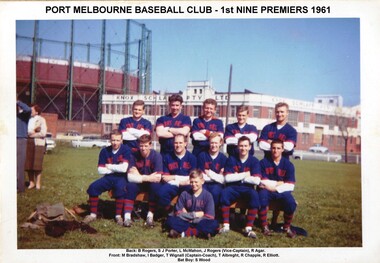
Photograph - Port Melbourne Baseball Club, 1st Nine Premiers, 1961
Back: B ROGERS, S J PORTER, L McMAHON, J ROGERS (Vice-Captain), R AGAR Front: I BADGER, T WIGNALL (Captain Coach). T ALBREGHT, R CHAPPLE, R ELLIOTT Bat boy: S WOODColour team photo of Port Melbourne Baseball Club - 1st Nine Premiers 1961. Background to team on Lagoon reserve shows the Knox Schlapps building and gasometersport - baseball, utilities - gas, built environment - industrial, built environment - commercial, parks and gardens, port melbourne baseball club, b rogers, s j porter, l mcmahon, j rogers, r agar, m bradshaw, i badger, t wignall, t albreght, r chapple, s wood, gasometer, knox schlapp pty ltd, lagoon reserve, r elliott -
Port Melbourne Historical & Preservation Society
Photograph - A E Wearne & Son Coachbuilders, corner Crockford and Ingles Streets, Port Melbourne, 1910
COPYRIGHT City of Port Phillip collection pm1036 Black and white photo of A E Wearne & Son Coachbuilders at the corner of Crockford and Ingles Streets. Motor vehicles were constructed here up until the 1930s. Photo shows staff lined up on footpath outside the building. Image used in 2015 PMHPS calendar (February)a e wearne & son, coachbuilder, transport - motor vehicles, transport - horse, built environment - industrial