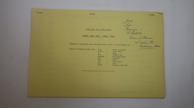
Showing 547 items matching "local historians"
-
 Flagstaff Hill Maritime Museum and Village
Cash Ball
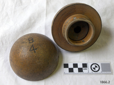
... of purchase”. [references: local historian John Lindsay, Warrnambool... on goods paid for at the time of purchase”. [references: local ...This cash ball was used by Cramond and Dickson, a large clothing store on the corner of Liebig and Timor Streets, Warrnambool. The Cash Ball system serviced the ground floor, which measured about 30 metres by 25 metres. An overhead pipe connected each service point in the store, with the pipes connected to the upstairs office. The ball would be filled with a note of details of the sale, and the cash payment; a vacuum system would be activated that would transport the ball upstairs to the office where details were recorded and change assembled. Change was placed in the ball, and the vacuum system activated to return the ball to the correct sales point. A frequent customer has reported that she never remembered the system not working efficiently, and the service was probably quicker than having a cash register at each sales location. John Glass Cramond and James Dickson migrated from Scotland to Melbourne where they opened a Cramond and Dickson store in St Kilda. They were inspired by the growth in Warrnambool after a visit and opened a second store there in 1855. The Cramond and Dickson store, grocers – drapery – ironmongery - chemist, was located on the corner of Liebig and Timor Streets, Warrnambool (now the site of a Mexican restaurant). Both Cramond and Dickson were involved in the business and social aspects of Warrnambool’s community. Cramond and Dickson closed in 1974. An advertisement placed by Cramond and Dickson in The Camperdown Chronicle, Saturday 6th April 1895, states them “showing the latest novelties for the coming winter season” … “import directly from English and Continental manufacturers” … “representatives in London … always in touch with the Newest Continental Fashions” ... “having been established for so many years we know the requirements of the Western District”… “allow 5 percent discount on goods paid for at the time of purchase”. [references: local historian John Lindsay, Warrnambool City Council’s CBD Heritage Trail leaflet, The Camperdown Chronicle, Facebook “Lost Warrnambool” site; WDHS Journal Volume 49 No2 2015] Cash ball, wooden, round, used by Cramond and Dickson clothing store. Two half spheres that fit into each other securely both are marked "B4" and one has "Fancy" marked on it.Carved into the surfaces of each half sphere are the characters "B4". Written on one is "Fancy"flagstaff hill, warrnambool, shipwrecked-coast, flagstaff-hill, flagstaff-hill-maritime-museum, maritime-museum, shipwreck-coast, flagstaff-hill-maritime-village, cash ball, cramond and dickson, office equipment -
 Eltham District Historical Society Inc
Photograph - Digital Photograph, Alan King, Cameron family graves, Kangaroo Ground Cemetery, Eltham-Yarra Glen Road, Kangaroo Ground, 28 January 2008
... soil which was hard to dig. According to local historian Mick... soil which was hard to dig. According to local historian Mick ...Six year old Judith Furphy was the first person known to have been buried at Kangaroo Ground Cemetery in May 1851. The cemetery is situated on an ancient river bed with exposed Nillumbik sands. The rest of the district is formed from black volcanic soil which was hard to dig. According to local historian Mick Woiwod (deceased) the site may have been a burial ground for the local Wurundjeri people as the exposed softer sands were always their prefered camping sites. The Hon. Ewen Hugh Cameron who lived at Pigeon Bank and was the Member for Evelyn for 40 years (1874-1914) was buried here in 1915. Published: Nillumbik Now and Then / Marguerite Marshall 2008; photographs Alan King with Marguerite Marshall.; p39 The Wurundjeri people might have buried their dead on the site of the Kangaroo Ground Cemetery, according to local historian Mick Woiwod. Kangaroo Ground was a premier hunting ground, but camping on the black volcanic soil would have been uncomfortable. Unlike most of Kangaroo Ground, its cemetery, on an ancient river bed, comprises a rare exposure of Nillumbik sands – always the preferred campsite for Aboriginal people. The cemetery area is the only place where the soil was soft enough to dig a grave easily.1 Six-year-old Judith Furphy was the first person known to have been laid to rest at the Kangaroo Ground Cemetery. She died on May 17, 1851, from a chill caught by resting on wet grass. Local Andrew Ross wrote ‘..no public burying place existed nearer than Melbourne. The case being considered urgent, a general meeting of the settlers took place on the evening of the 17th……. The result was the selection of unoccupied crown land …….which was subsequently granted by Government for a public cemetery.’2 Judith was buried the next day on May 18. Her grave was marked by the trustees with a plaque, which unfortunately states nine years old, when she was probably only six. Judith came from an illustrious family. Her brother, Joseph, was the author of Such is Life and other works. Another brother, John, developed and manufactured the famous Furphy water cart, which distributed water to World War One soldiers along with the latest rumours. Hence the name Furphy entered the Australian idiom, as synonymous with ‘rumour’. Judith’s father Samuel helped build the first Kangaroo Ground church school. Inside, near the entrance of the cemetery, on Yarra Glen Road, stand a rotunda and a water tank. Occasional benches invite mourners to pause and remember. The gate with wrought iron and brick supports, bears the inscription ‘Erected by Sir Ewen and Lady Cameron in memory of their daughter, Flora Margaret’. These are only two of the famous people connected with this cemetery. The Hon. Ewen Hugh Cameron JP and MLA from 1874 to1914, who lived at Pigeon Bank, Warrandyte Road, was buried here in 1915. Unrelated, but with the same name, was Sir Ewen Cameron who had been Minister for Health and was laid to rest there in 1964. Sir Herbert Gepp, a leading industrialist and the former owner of Garden Hill, at Yarra Glen Road, was buried there in 1954.3 Many of the more imposing tombstones belong to the earlier graves. Unfortunately bushfires have cracked several. But this adds to the melancholy attractiveness of the cemetery, graced by some beautiful eucalypts, cypress and pines. Early pioneering families represented at the cemetery include Armstrong, Barr, Bell, Harkness, Jardine, Johnston, Rogerson, Stevenson, Thomson and Walters. Armstrong and Bell were among the first families to come to the district and Stevenson owned the district’s first sheep station. It took in much of present day Christmas Hills, which was the name he gave his sheep station. Harkness was the first to suggest a Kangaroo Ground school be built, and one of the first to suggest establishing the Eltham District Road Board. Many of these families leased pastoral land before the mid-century and bought land when it came on sale in 1849. In the cemetery’s early days sections were devoted to the major Christian denominations (mainly the Protestant) and one section was set aside for ‘other’ or ‘non-believers’. However in modern times burial plots have not been placed in areas according to religious beliefs.This collection of almost 130 photos about places and people within the Shire of Nillumbik, an urban and rural municipality in Melbourne's north, contributes to an understanding of the history of the Shire. Published in 2008 immediately prior to the Black Saturday bushfires of February 7, 2009, it documents sites that were impacted, and in some cases destroyed by the fires. It includes photographs taken especially for the publication, creating a unique time capsule representing the Shire in the early 21st century. It remains the most recent comprehenesive publication devoted to the Shire's history connecting local residents to the past. nillumbik now and then (marshall-king) collection, kangaroo ground, eltham-yarra glen road, agnes bell cameron, agnes cameron (nee bell), cameron family, edward aubrey haughton, eugene cameron, evelyn florence cameron, ewen hugh cameron, gravestones, jane armstrong, jane bell, jessie agnes haughton (nee cameron), jessie cameron, john donald cameron, kangaroo ground cemetery, neville cameron, simon armstrong, vera cameron, william bell armstrong, wurundjeri -
 Flagstaff Hill Maritime Museum and Village
Photograph, 1883-1888
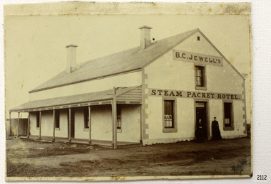
... ; Fact Sheet - Flagstaff Hill Maritime Village; local historian...; Fact Sheet - Flagstaff Hill Maritime Village; local historian ...This photograph taken between 1883-1888, shows the Steam Packet Inn, which was at the end of Stanley Street in Warrnambool, close to the Breakwater and Port of Warrnambool. It was renamed later as the Lady Bay Hotel. THE STEAM PACKET INN The Steam Packet Inn was originally located at the end of the first jetty that ran out into Lady Bay. It was purchased by Manifold and Bostock in 1854 with the first building being a private BOND STORE. An old horse-drawn tramway went past the Bond Store and out onto the Jetty, providing a method of transporting goods. The Bond Store was converted in 1863 into a hotel named the Western Steam Packet and then called the STEAM PACKET HOTEL or INN, a stone building. The Steam Packet Inn building was owned by E.D. Evans of the firm of Evans and Gleeson, livery stables. The Steam Packet Inn’s licensee between 1883-1888 was B.C. Jewell. In 1889 the building was reconstructed and a second storey added. At this time (1889-1890) the name was changed to the BAY VIEW HOTEL. The hotel was extensively damaged by the first of the two earthquakes in Warrnambool in 1903. The hotel was renamed LADY BAY in 1954 and altered and enlarged. It then occupied the site of two former hotels, the Bayview and the Prince of Wales. When the Lady Bay Hotel was demolished a few years ago to make way for the Lady Bay Apartments the original walls of the old Steam Packet Hotel were still clearly visible inside the main bar area. STEAM PACKET INN and BOND STORE at FLAGSTAFF HILL MARITIME VILLAGE (Note that there are two buildings at Flagstaff Hill Maritime Village, a Manifold and Bostock Bond Store and a Steam Packet Inn with a licensee, B. Jewell (1883-1888), both remembering the one building that incorporated these two institutions in Warrnambool’s past. The current Steam Packet Inn in the Flagstaff Hill Maritime Village has an image of one the licensee's B.C. Jewell. Today The Steam Packet Inn, provides Flagstaff Hill Maritime Village with a great venue to host some of our events through the year and can be used for functions upon request.) [References; Fact Sheet - Flagstaff Hill Maritime Village; local historian Glenys Phi8lpot] The subject of this photograph, the Steam Packet Inn, is of local historical significance for its role in the port of Warrnambool shipping trade in the mid to late 1800's. Photograph of B C Jewell's Steam Packet Inn, Warrnambool, 1883-1888. flagstaff hill, warrnambool, shipwrecked-coast, flagstaff-hill, flagstaff-hill-maritime-museum, maritime-museum, shipwreck-coast, flagstaff-hill-maritime-village, photograph of steam packet inn, steam packet inn warrnambool, lady bay hotel warrnambool, warrnambool breakwater, port of warrnambool, stanley street warrnambool, warrnambool jetty, manifold and bostock, bond store warrnambool, western steam packet, e.e. evans, b.c. jewell, bayview hotel warrnambool -
 Southern Sherbrooke Historical Society Inc.
Document - Helen Gibson obituary
... also been fondly remembered as a local historian and a woman... also been fondly remembered as a local historian and a woman ... -
 Bendigo Historical Society Inc.
Newspaper - PETER ELLIS COLLECTION: RECOLLECTIONS PICTORIAL LIFTOUT
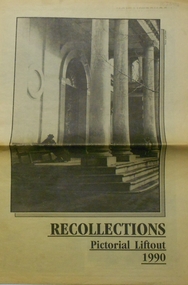
... ceiling. 19 new town hall 1861. Mike Butcher, local historian. 21..., local historian. 21 Interior plan of city hall (ground floor) 22 ...Historical lift out. Newspaper. Titled RECOLLECTIONS Pictorial Lift out 1990.1 looking down Mitchell St. from Railway Bridge. 2 Original railway station viewed from Mitchell St. bridge. 3 The great extended Hustlers mine. 4 1873 photo recently extended town hall with corn exchange at front left. 5 looking north westerly from city rec reserve at royal hustlers. 6 children play on mullock heap in front of a view of westerly quarter of Sandhurst. 7 Bank of Victoria, Mitchell St. left is Bendigo's original post office. 8 Looking down from what is now Rosalind Park. Shamrock Hotel can be seen on corner of Williamson St. and Pall Mall. This photo predates the construction of post office and law courts. 9 girl eating fairy floss. 10 4 kids on 1 horse in procession. 11 monkey and pedal car, a novelty attraction 1940's. 12 pony rides. 13 flying horses (ride). 14 processions past city hall. 15 Original ANZ bank corner Williamson St. & Pall Mall. 16 Chinese Dragons Bendigo Easter Fair 1940's. 17 City Hall viewed from Bull St. 18 City Hall original ceiling. 19 new town hall 1861. Mike Butcher, local historian. 21 Interior plan of city hall (ground floor) 22 circa 1920's 23 Tattered fragment original architect's drawing. 24 original assembly room. 25 Camp Hill PS Shamrock hotel without top story 27 shop with signage advertising Bushells, Bex and Swallow's Biscuits. 28 View from where fountain is now. 29 Hargreaves St. Looking south, now Hargreaves mall. Horse drawn water tank watering down road. 30 Central Deborah Gold mine poppet head. 31 Borough town hall, tram ways. 32 Original ANZ Bank corner Williamson St. and Pall Mall, demolished in mid 1960's. 33 Bush's store corner Williamson and Myer streets.34 Men on boat, don't know what or where. 35 Shearers. 36 men on a three wheeled bike. 37 4 Gold miners with shovels. 38 6pm closing, no trade Sundays, no women in main bar. 39 Peaceful scene Castlemaine 1940's Photographer Alan Doney. 40 Qantas Jet the City of Bendigo Tullamarine Airport. BCV-8 camera man & Advertiser photographer. 41 Ladies. 42 Tennis -> men and women (women in hats). 43 Sandhurst footy team. 44 Early school photos.bendigo, history, photographic history -
 Bendigo Historical Society Inc.
Document - RE-DEDICATION OF THE BENDIGO TEMPLE, VIEW STREET, BENDIGO, 19 October 1974
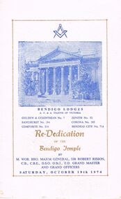
... 1874-1974. Local historian..., 1874-1974. Local historian, Bro. J. N. Macartney, in his book... View Street Bendigo 1874-1974. Local historian Bro. J. N ...a/ Re-Dedication of the Bendigo Temple, View Street, Bendigo. By M. Wor. Bro. Major General, Sir Robert Risson, C.B.E., D.S.O. O.St.J., E.D. Grand Master and Grand Officers. Saturday, October 19th 1974. Bendigo Lodges A. F. & A. Masons of Victoria. Golden & Corinthian No. 7, Zenith No. 52, Sandhurst No. 194, Corona No. 195, Composite No. 314, Bendigo City No. 714. Re-Dedication Team Presiding Officer: M.W.Bro. Sir. Robert Risson, G.M. Deputy Grand Master R.W.Bro. C. R. B. James, D.G.M. Grand Master of Ceremonies V.W.Bro. L. Retchford, G.D.C. Senior Grand Warden R.W.Bro. L. G. Grant, S.G.W. Junior Grand Warden R.W.Bro. A. J. L. W. Greenwood, J.G.W.Grand Chaplain V.W.Bro. Rev. J.R. Lawton, G.Chap. Grand Supt. Of Works V.W.Bro. F. C. Galbraith, G I.Wkgs. Grand Secretary R.W.Bro. G. W. Jackson, P.D.G.M., G.Sec. Grand Deacons for Dedication Wor.Bro. B. A. McMillian, S.G.D. and Wor.Bro. D. E. Plaisted, J.G.D. Grand Sword Bearer Wor.Bro. J. R. Evans, G.Swd.B. Gand Organist Wor.Bro. J. N. Cowan, G.Org. Grand Pursuivant Wor.Bro. A. A. Eagle, A.G.Purs. Grand Herald Wor. Bro. P. J. Grenfell, P.G.Std.B., G.Her. Censer Stewards Wor. Bro. H. J. Blunden, G.Stwd. And Wor.Bro. B. D. Cross, G.Stwd. Historical, Brief History on Bendigo Masonic Temple, View Street, Bendigo, 1874-1974. Local historian, Bro. J. N. Macartney, in his book had this to say:- ''The Masonic Hall is by far the grandest building in Sandhurst (Bendigo), and a fitting and right noble home for such an Order to place their ark in. The building is one on the pure Corinthian order, lofty without, and spacious within; therein is the finest Assembly Hall out of Melbourne Town Hall. What an imposing façade, with its tapering columns rearing the graceful acanthus-leaf capitals 40 feet. . . . With the growth of Freemasonry in Bendigo, new Craft Lodges were established, as were lodges of higher degrees. At present the following lodges use the Temple and hall facilities:- Golden & Corinthian Lodge No. 7. Zenith Lodge, No. 52. Sanhurst Lodge, No. 194. Corona Lodge No. 195. The Lodge Composite, No. 314. Bendigo City Lodge, No. 714. The Bendigo Lodge of Mark Master Masons, No. 12. Royal Golden Chapter, No. 3. The Bendigo Royal Ark Mariner Lodge, No. 12. The Bendigo Conclave, No. 143. Bendigo Masonic Lodge of Instruction, No. 14. Bendigo Sovereign Council, No. 16. Bendigo Sovereign Chapter No. 32. The National Trust of Australia has done much to preserve our heritage for the succeeding generations. In 1972 the Masonic Temple and Hall Received their ''D'' Classification. . . Program. Toasts and Harmony. Bro. C. Phillips. Wor. Bro. D. L. Killian, P.J.G.D. Bro. R. D. McPherson. b/ (letter) 3 Brodie St. Bendigo 3550. 28.10.1974. The Secretary, Bendigo Branch, RHSV, Bendigo. Dear Miss Parry, Bendigo Masonic Hall, The enclosed programme contains a short history of the above, and comes to your Society with the compliments of the Board of Management of the Bendigo Masonic Hall. Yours sincerely, Alex M Stone.a/ re-dedication of the bendigo temple, view street, bendigo. by m. wor. bro. major general, sir robert risson, c.b.e., d.s.o. o.st.j., e.d. grand master and grand officers. saturday, october 19th 1974. bendigo lodges a. f. & a. masons of victoria. golden & corinthian no. 7, zenith no. 52, sandhurst no. 194, corona no. 195, composite no. 314, bendigo city no. 714. re-dedication team presiding officer: m.w.bro. sir. robert risson, g.m. deputy grand master r.w.bro. c. r. b. james, d.g.m. grand master of ceremonies v.w.bro. l. retchford, g.d.c. senior grand warden r.w.bro. l. g. grant, s.g.w. junior grand warden r.w.bro. a. j. l. w. greenwood, j.g.w.grand chaplain v.w.bro. rev. j.r. lawton, g.chap. grand supt. of works v.w.bro. f. c. galbraith, g i.wkgs. grand secretary r.w.bro. g. w. jackson, p.d.g.m., g.sec. grand deacons for dedication wor.bro. b. a. mcmillian, s.g.d. and wor.bro. d. e. plaisted, j.g.d. grand sword bearer wor.bro. j. r. evans, g.swd.b. gand organist wor.bro. j. n. cowan, g.org. grand pursuivant wor.bro. a. a. eagle, a.g.purs. grand herald wor. bro. p. j. grenfell, p.g.std.b., g.her. censer stewards wor. bro. h. j. blunden, g.stwd. and wor.bro. b. d. cross, g.stwd. historical, brief history on bendigo masonic temple, view street, bendigo, 1874-1974. local historian, bro. j. n. macartney, ''the masonic hall the grandest building in sandhurst (bendigo), corinthian order, finest assembly hall. golden & corinthian lodge no. 7. zenith lodge, no. 52. sanhurst lodge, no. 194. corona lodge no. 195. the lodge composite, no. 314. bendigo city lodge, no. 714. the bendigo lodge of mark master masons, no. 12. royal golden chapter, no. 3. the bendigo royal ark mariner lodge, no. 12. the bendigo conclave, no. 143. bendigo masonic lodge of instruction, no. 14. bendigo sovereign council, no. 16. bendigo sovereign chapter no. 32. national trust of australia preserve our heritage. in 1972 received their ''d'' classification. . . program. toasts and harmony. bro. c. phillips. wor. bro. d. l. killian, p.j.g.d. bro. r. d. mcpherson. b/ (letter) 3 brodie st. bendigo 3550. 1974. bendigo branch, rhsv, bendigo. miss parry, programme short history board of management of the bendigo masonic hall., alex m stone. -
 Eltham District Historical Society Inc
Photograph - Digital Photograph, Marguerite Marshall, Hawthorn hedges, Eltham-Yarra Glen Road, Kangaroo Ground, 3 October 2006
... and the hedgerows were not trimmed. Then in late 2005, local historian Mick... and the hedgerows were not trimmed. Then in late 2005, local historian Mick ...Hawthorn hedges are important reminders of Kangaroo Ground's Scottish heritage. They are Registered on the Victorian Heritage Register. They are "historically significant because the planting of hawthorn hedges reflects the adoption of Eurorpean farming techniques by the Kangaroo Ground population in the period following settlement and because the grid pattern of paddocks that the Hawthorn hedges define is very different to today's farm landscapes." Covered under Heritage Overlay, Nillumbik Planning Scheme. Published: Nillumbik Now and Then / Marguerite Marshall 2008; photographs Alan King with Marguerite Marshall.; p21 Hawthorn hedges bordering Kangaroo Ground’s gently rolling farmlands are important reminders of its Scottish heritage and are rare so close to Melbourne.1 As early as the 1840s newly arrived farmers from Scotland planted hawthorn hedges around their properties, to protect crops from the numerous kangaroos and wallabies. Many of these hedges survive today. These farmers had the good fortune to settle some of the most fertile land available for cropping in the Colony of Victoria. At that time the black volcanic soil could sustain an amazing two crops a year. By the mid 1850s, 500 acres (202ha) of wheat were growing in Kangaroo Ground. But the crops were threatened by kangaroos, which were so plentiful, that Surveyor-General, Robert Hoddle, named the district Kangaroo Ground in 1838. As post-and-rail fences proved inadequate barriers for the bounding kangaroos, the Scots planted hawthorn hedgerows as they had done in Scotland. Some also used the hedges to net birds, presumably for the table. Interestingly the farmers in the bordering townships of Panton Hill and Christmas Hills, did not plant hawthorn hedges around their properties. Perhaps it was because by the time they settled in the 1860s and 1870s most of the wildlife had been gunned down by residents.2 The canny Scots planted the hedges on public land outside their own farms, as the hedgerows could spread to about five yards (five m) in width. With this impenetrable barrier Kangaroo Ground’s industrious farmers flourished to gain the economic power that saw the Shire of Eltham governed from Kangaroo Ground for 79 years (1858-1937). The Scots jealously guarded their land, so hard to get in Scotland. That is why they refused to release any of it ‘for local roads to follow easier grades as was the case in surrounding districts where roads generally followed ridgelines or streams’.3 Instead the roads were built in accordance with the magnetic bearings of their first survey in 1847 whether that suited the steep topography or not. This could force traffic to diverge when wet through Greensborough and Diamond Creek. Until 1921, the Eltham-Yarra Glen Road beside Wellers Restaurant, ‘dipped down into the upper reaches of Stony Creek’.4 Later some corners were compulsorily cut for the increasing motor traffic. As late as the 1960s, corners were cut to form sweeping curves above and alongside the Kangaroo Ground Cemetery and opposite the Emergency Operations Centre. In the latter case, the farmers – understanding their hedgerows as important heritage – insisted upon their reinstatement to conform to the altered road alignment. Kangaroo Ground’s ancient manna gums also point to the district’s history and to that of the hedgerows. The Aboriginal people had transformed the original forests into grasslands with the fires they lit to attract kangaroos, (which the Scots were to exclude by planting hedgerows). But the Wurundjeri hunters left the gums (Eucalyptus vimminalis cygnetensis), on the grasslands as ‘stalking trees’ to hunt kangaroos. The hawthorn hedges in Kangaroo Ground were neglected for around 60 years from about the middle of the 20th century. Bushfires had created gaps and the hedgerows were not trimmed. Then in late 2005, local historian Mick Woiwod, formed a group to lobby the Nillumbik Shire to restore the hedges, which could last for many centuries. Some hedges in parts of Britain date back to AD 800.5 Although the original Scottish farmers have gone, the hedges are a reminder of when they flourished in the district, which has changed little in 150 years.This collection of almost 130 photos about places and people within the Shire of Nillumbik, an urban and rural municipality in Melbourne's north, contributes to an understanding of the history of the Shire. Published in 2008 immediately prior to the Black Saturday bushfires of February 7, 2009, it documents sites that were impacted, and in some cases destroyed by the fires. It includes photographs taken especially for the publication, creating a unique time capsule representing the Shire in the early 21st century. It remains the most recent comprehenesive publication devoted to the Shire's history connecting local residents to the past. nillumbik now and then (marshall-king) collection, eltham-yarra glen road, hawthorn hedgerow, kangaroo ground -
 Eltham District Historical Society Inc
Photograph - Digital Photograph, Alan King, Memorial Arch Gateway, Nillumbik Cemetery, Diamond Creek, 23 January 2008
... was grandfather of local historian Reverend Jock Ryan. He was buried... was grandfather of local historian Reverend Jock Ryan. He was buried ...The Nillumbik Cemetery is of historical, architectural, aesthetic and social significance at a Regional level (North-east Melbourne). The memorial arch is of State significance. Nillumbik Cemetery, which was established in 1867, is of historical and social significance for its association with the early history of Diamond Creek and as a record of the pioneering families of the district. Significant graves include those of the famous writer Alan Marshall, author of 'I Can Jump Puddles', footballer Gordon Coventry, and William Ellis, notable early settler and benefactor. The 1897 Tudor/Gothic revival memorial arch, bequeathed by William Ellis, is a rare design in ornamental gateways and is relatively large for the size of the cemetery. It is unique in Victoria as a cemetery gateway arch. The burial ground has associated structures, such as the hexagonal timber sexton's office, post and wire fence and picket hand gate along Main Street, all probably built in the early twentieth century. Covered under Heritage Overlay, Nillumbik Planning Scheme. National Trust of Australia (Victoria) - Regional significance Published: Nillumbik Now and Then / Marguerite Marshall 2008; photographs Alan King with Marguerite Marshall.; p83 Entering Nillumbik Cemetery through an ornamental gateway and shaded by the Monterey Cypress hedge helps one leave the busy world outside and contemplate yesterday’s Diamond Creek. The gateway, classified by the National Trust of Australia (Victoria), and inscribed with ‘JANVA VITAE’ (gate of life), was a gift from a distinguished pioneer, William Ellis. Ellis, who was an original trustee of the Nillumbik Cemetery representing the Primitive Methodists and a successful farmer, bequeathed £100 to build the red-brick and carved stone gateway in 1887. In 1867 surveyor Edward Bage had set aside two acres (0.8ha) now 35 Main Street, for this cemetery, in what was then called the village of Nillumbik. Several earlier burials on private lands in the district might have been exhumed and re-interred in the new cemetery. The first burials in the cemetery are thought to be of ‘a Chinaman who hanged himself from a tree behind the Church of England’ and ‘another man who was drowned in a water-hole behind the same church’.1 The 1000 or so graves in the cemetery are grouped into five denominational sections: two Anglican and one each for the Methodist (the largest), Catholic and Presbyterian Churches. It is believed that several unmarked graves are of Aborigines and Chinese miners.2 Perhaps the most famous person buried in the cemetery was author Alan Marshall, who died in 1984 and wrote, among other books, I Can Jump Puddles. Surprisingly his grave is particularly modest consisting of only a grassed plot with a tiny boulder and a simple bronze plaque. It lies about halfway down the main path, at the west and third row back. The first European, interred at the cemetery on July 9, 1869, was Hannah, aged 13 years eight months, daughter of local orchardist John Lawrey and wife Honor.3 Each grave has a story which reflects a rich history. Phillip Cummings, who died in 1884, provided the barn for Diamond Creek’s first school, run by the Primitive Methodist Church. The barn stood at the corner of Phipps Crescent and the main road.4 Former Eltham Shire councillor George Stebbings, who died in 1896, built several prominent buildings in the district, including Shillinglaw Cottage in Eltham.5 The grave of miner James Joseph Whyte, who died in 1908, is a reminder of Diamond Creek’s gold mining history. At age 51, Whyte died from a rock fall in the Diamond Mine, Diamond Creek. Diamond Creek’s first butcher, Patrick Ryan, became President of the Shire of Heidelberg and Chairman of the Eltham Hurstbridge Railway Trust. A former gold miner, he was grandfather of local historian Reverend Jock Ryan. He was buried in an unmarked grave halfway down the central path. His son John Lawrence, who is buried elsewhere, had been a Mayor of the City of Heidelberg. George Martin Pizzey gave a hall, for what was to become The St John’s Anglican Church in Diamond Creek. He was a Crimean War veteran, mason and leather goods manufacturer in Melbourne, who died in 1915. The two world wars took a heavy toll of locals with 54 personnel buried here, two thirds of whom served in World War One. A sporting pioneer was Greensborough District Cricket Club founder, Andrew Webb, who was buried in 1971. Politician Roy Mountford Vale (Monte), who died in 1977, was a Member of the Legislative Assembly of Greensborough, and a founding councillor and president of the Diamond Valley Shire. Modern-day residents are also remembered in this cemetery. The tragic Ash Wednesday bushfires took their toll on the district: William Marsden of Panton Hill CFA died, aged 39, fighting bushfires at Upper Beaconsfield in 1983.6 Several graves tell of those who held distinguished positions overseas, including William Constable, who died in 1989. Constable was artistic director of a ballet company, art director of more than 30 films for London-based film productions, and was awarded best Film Art Director at the Moscow Film Festival in 1960.This collection of almost 130 photos about places and people within the Shire of Nillumbik, an urban and rural municipality in Melbourne's north, contributes to an understanding of the history of the Shire. Published in 2008 immediately prior to the Black Saturday bushfires of February 7, 2009, it documents sites that were impacted, and in some cases destroyed by the fires. It includes photographs taken especially for the publication, creating a unique time capsule representing the Shire in the early 21st century. It remains the most recent comprehenesive publication devoted to the Shire's history connecting local residents to the past. nillumbik now and then (marshall-king) collection, diamond creek, memorial arch, gateway, nillumbik cemetery, william ellis -
 Flagstaff Hill Maritime Museum and Village
Document - Framed Poster, Borough of Warrnambool, Victoria, Australia, after 30/06/1875
... of December 19, 1981, written by local historian Bruce Morris... the Warrnambool Standard of December 19, 1981, written by local historian ...This document, also referred to as a word picture or Tablet, is framed in glass and timber with gilt trim, is handwritten with colour highlights. The penned letters rest on ruled guide lines, decorated where the lines intersect. The writing gives a description of the state of Borough of Warrnambool around 1875; its location, the area it covers, its population, Harbour and facilities, public buildings and institutions, imports and exports, financial worth, number of houses, connection with other areas of the Colony. A possible reason and origin for the document is found in an article ‘Link with US Exhibition’ from the Warrnambool Standard of December 19, 1981, written by local historian Bruce Morris. The writer mentions that the Warrnambool Borough Council met on 15th June 1875 and recorded a letter from G.C. Levey , secretary to the Melbourne group of commissioners representing the Colony, and Victoria in particular, for the Philadelphia Centennial Exhibition of 1876. The letter asks Council to provide “statistics as to the population, social condition and commercial and industrial state of the district in and around Warrnambool.” A sub committee was formed for the project. The Mayor, Cr. Thomas King, wrote and signed a Report, presented to the council on July 14, 1875, in which “The Committee … begs to recommend that a Tablet be prepared setting for the particulars respecting the following matters relating to the Borough”. The matters included area, population, annual income, churches, schools, other public buildings, societies and companies, general description of houses erected, and returns of exports and imports for 1874. The minutes note that the Report was adopted. The article above also notes the opinion of Warrnambool printers who have examined the document; it is almost certainly to be an old lithograph, which means there could be several copies. It is possible that there may be a copy in Melbourne and another in Philadelphia. It is interesting to note that (1) the quoted location co-ordinates are for an “Unnamed Road, Packsaddle NSW 2880, Australia”, and that the DMS co-ordinates for Warrnambool’s Council Offices differ, being 38.23.9.12 South, 142.28.52.887. (2) the date for “Exports and Imports for the Year Ending 30th June 1875” is different to the period mentioned by Cr. King in the sub committee’s Report of recommendation “returns of exports and imports for 1874”. The information required to have the figures for the end of June 1875 would need to have been compiled very quickly for the Tablet to be ready for the opening of the Philadelphia Exhibition on 10 May 1876. The document/certificate shows the following – - - - - - - - - - - - - - - -- - - - - - - - - - - - - - -- - - - - - - - - - - - - - -- - - - - - - - - - - - - - - “Victoria Australia, Borough of Warrnambool. Latitude, 30.24.50 South, Longitude 142.32 East The Principal Port in the Western District of the Colony and the Centre of its Choicest Agricultural Lands. Established a Municipality in 1855, and Created a Borough 1863. Population in 1875 4,500. Warrnambool is the nearest Port to Melbourne on the Western Seaboard, being about 160 miles distant. Coaches run to and from the Metropolis daily, in connexion [connection] with the Railway of Geelong and Steamers belonging to Local Companies sail between Melbourne, Warrnambool, Belfast [renamed Port Fairy], and Portland several times weekly. The Harbour is known as Lady Bay, and is partially protected by a reef of rocks stretching from the mouth of the Hopkins River. The formation of a Breakwater has been decided upon by the Government, to extend 600 yards, at an estimated cost of £100,000. There are two substantial Jetties, one of 800 and the other of 600 feet in length. The former is connected with the Town by means of a Tramroad, along which Goods, inwards & outwards, are conveyed, & the latter has been constructed solely for the purpose of facilitating the transit of material for the formation of the Breakwater. In addition to the trade of the Borough and District, the principal Townships up country receive their supplies from Melbourne and ship their exports through Warrnambool. Potatoes form the staple produce of the district, and the richness of the soil can be estimated by the fact that the Government Statistics for 1875 give as the average yield a return of Seven Tons to the acre. Several thousand acres between Warrnambool and Tower Hill are now being laid down in Potatoes by Tenants who have leased the lands at rates up to £5 per acre for the season 1875-6. Wool, Tallow, hides &c are also largely exported, while the shipments of all descriptions of Farm Produce are annually increasing. Area of Borough, 3362 Acres. Net Annual Value £27,000. Annual Revenue £5,500. Number of Houses in Borough 800. Public Buildings and Institutions Churches. Church of England, Roman Catholic, Presbyterian, Wesleyan, Congregational and Baptist. Schools. Three State Schools, average attendance nearly 1000. New Building in course of erection. Several private establishments. Banks. Bank of Australasia, Bank of Victoria, National Bank, Colonial Bank and Savings Bank. Public Buildings. Court house, Custom house, Post & Telegraph Offices, Survey & Land Offices, Shire £, Town Hall, Mechanics Institute, Volunteer Orderly Room, Odd Fellows Hall, Hospital & Benevolent Asylum, Temperance Hall &c. Companies & Societies. Steam Navigation Co, Woolen Mill Co, Gas Co, Racing Club, Amateur Turf Club, Agricultural Society, Farmers’ Club, Cricket Club, Anglers’ Society, Building Society, Freemasons Odd Fellows, Foresters, Druids, Hibernians. Protestant Alliance, Rechabites, Sons of Temperance, &c, Fire Brigade &c. --- Exports and Imports for the Year Ending 30th June 1875 –-- --Exports Total Tonnage 27,800 (Calculated at the Current Warrnambool Market Prices) Potatoes Wool Wheat Barley Hides Skins Fowls Butter Cheese Eggs Tallow Leather Ale Pigs Sheep Sundries --Imports 13,000 Tons Of the Estimated Value of £520,000 Total Tonnage of Exports and Imports 40m900 Tons, Value £806,627 Passenger Travels, to ad from Warrnambool during year, 10,000 persons Revenue from all sources paid through Warrnambool Sub Treasury From 1860 to June 1875 £1, 292, 300 Thomas King [signed] Mayor Henry T Read [signed] Town Clerk” - - - - - - - - - - - - - - -- - - - - - - - - - - - - - -- - - - - - - - - - - - - - -- - - - - - - - - - - - - - - The document is of historical, social, economic and local significance in that it summarises activities, business, community, trade, travel and government at a point in time in Warrnambool’s history – 30th June 1875.Document, also referred to as a ‘word picture’ or ‘tablet’. Document is framed in glass and timber with gilt trim, handwritten with colour highlights. The penned letters rest on ruled guide lines, decorated where the lines intersect. Document outlines the establishment of Warrnambool as a Municipality in 1855 and Borough in 1863, with a population of 4,500 in 1875. It states geographic location, public buildings and institutions, harbor facilities and imports and exports for the year ending 30th June 1875. Two signatures "Thomas King" Mayor and "Henry T Read" Town Clerk. It shows the Coat of Arms of the Borough of Warrnambool.Signatures - "Thomas King" Mayor and "Henry T Read" Town Clerk. Warrnambool Coat of Arms; “British Coat of Arms, above sailing vessel and sheaf of wheat in sun, motto “By these we flourish” and around circumference “Borough of Warrnambool 1855”flagstaff hill, warrnambool, shipwrecked coast, flagstaff hill maritime museum, maritime museum, shipwreck coast, flagstaff hill maritime village, great ocean road, borough of warrnambool, municipality of warrnambool, document borough of warrnambool 1875, word picture of warrnambool 1875, tablet of borough of warrnambool 1875, statistics borough of warrnambool 1875, lithograph borough of warrnambool 1875, coat of arms warrnambool, warrnambool city motto – in these we flourish, establishment of warrnambool, warrnambool history, thomas king mayor of warrnambool, henry t read town clerk of warrnambool, warrnambool breakwater, warrnambool jetty, warrnambool imports and exports 1875, warrnambool agriculture 1875, warrnambool business 1875, warrnambool population 1875, centennial exhibition philadelphia 1876, framed certificate -
 Eltham District Historical Society Inc
Folder, Material prepared by Harry Gilham pertaining to draft Eltham Major Activity Structure Plan, 2004, 2004
... and local historians call upon Nillumbik Council to reject moves... and local historians call upon Nillumbik Council to reject moves ...Specific focus on history of and impact to the Eltham War Memorial property. Contents: Eltham Major Activity Structure Plan Comments Sheet; Response by Harry Gilham, 22 June 2004 Minutes for the policy and Services Committee of Nillumbik Shire Council held Wednesday 11 August 2004 Photocopy of Eltham War Memorial Trust Booklet cover and Honour Roll Board in Eltham War Memorial Hall Photocopy of newsclippings - Eltham War Memorial Trust: Ready Now for Forward Movement; Acknowledgements £722; publication unknown, c.1946 and Eltham War Memorial Trust: "Garden of Remembrance"; Baby Health Centre First Building, The News: The Newspaper of the City of Heidelberg and of the Shire of Eltham, 11 April 1947 (EDHS_04588) Abbreviated notes of the Eltham War Memorial Trust, Harry Gilham, February 1997 Notes prepared by Harry Gilham pertaining to draft Eltham Major Activity Structure Plan, 2004 referencing Memorial Hall Site Title (p45), EGAG on heritage (p73) and Design Guidelines (p73) Copy of Certificate of Title issued to Eltham War Memorial Trust Ordinary Meeting of Council Agenda, 15 September 2004, p55 with notes on vote for motion that any reference to the sale of the War Memorial be removed Letter from Cr Tony Raunic, Mayor to Harry Gilham regarding Eltham Major Activity Centre Structure Plan advising the removal of any reference to sale of the War Memorial and detailed consultation to be held with stakeholders regarding the former Shire of Eltham Office site; 8 October 2004 Copy of fax sent by John Cohen, OAM, JP to Diamond Valley News, re his support for the appeal for protection of the Eltham War Memorial 3 July 2004 Copy of letter sent by John Cohen, OAM, JP to the CEO, RSL Victoria requesting their opposition to sale of the Eltham War Memorial, 19 August 2004 Copy of letter sent by John Cohen, OAM, JP to Brigadier J.R. Deighton, State Secretary, Victorian RSL re his comments in Diamond Valley Leader regarding the Eltham War Memorial, 27 August 2004 Copy of letter sent by John Cohen, OAM, JP to Brigadier J.R. Deighton, State Secretary, Victorian RSL advising the War Memorial had been removed from the wider proposal of the Eltham Activity Centre, 16 September 2004 Fax from Catherine Dale, CEO, Nillumbik Shire Council to John Cohen re Renovation and Maintenance of Victorian War Memorials, 6 October 2004 Letter from Barry Rosewall, President, Eltham RSL to John Cohen advising the sub-branch strongly opposes the sale of the Eltham War Memorial, 20 October 2004 Fax from Bill Forrest, Interim CEO, Nillumbik Shire Council to John Cohen re Renovation adn Maintenance of Victorian War Memorials, 8 November 2004 Copy of letter from John Cohen to Bill Forrest, Interim CEO, Nillumbik Shire Council re Maintenance of Eltham War Memorial, November 2004 Handwritten notes prepared by Harry Gilham in preparation of presentation to Council pertaining to draft Eltham Major Activity Structure Plan, 2004 Letter from Eric Mack to the Hon. Steve Herbert,, Member for Eltham regarding draft Major Activity Centre Structure Plan, 22 June 2004 Letter from Eric Mack to Nillumbik Shire Council CEO and Councillors regarding draft Major Activity Centre Structure Plan, 2004 Reply to Eric Mack from the Hon. Steve Herbert, Member for Eltham regarding his letter of 22 June, 27 July, 2004 Copy of letter from John Cohen to President and Exectuive of the Eltham RSL regarding the Eltham War Memorial, 16 July 2004 Notice issued by Cr Greg Johnson of 11 August meeting by Council's Policy and Services Committee to consider a proposal to sell the Eltham War memorial and old shire office properties, 6 August 2004 Letter from Harry Gilham, President, Eltham District Historical Society to Diamond Valley Leader wishing to correct a historical inaccuarcy being circulated in the Draft Structure Plan for the Elham Major Activity Centre, 17 June 2004 Newspaper clipping - Protect war memorial, Harry Gilham, President, Eltham District Horical Society; Letter, Diamond Valley Leader, June 30, 2004, p16 Newspaper clipping - Sell-off a betrayal of trust, Ken Eckersall; Letters, Diamond Valley Leader, c.2004 Newspaper clipping - Don't insult memory of fallen servicemen, John Cohen; Letters, Diamond Valley Leader, c.2004 Newspaper clipping - Up in arms against sell-off, Dave Crosswaite, Diamond Valley Leader, July 14, 2004, p5 (War veterans and local historians call upon Nillumbik Council to reject moves to sell Eltham War memorial buildings to a private developer. Features a picture of John Cohen, Harry Gilham and Dr Ken Eckersall. On same page - "First Aboriginal mural by trust opens" by Dave Crossthwaite about a mural celebrating stories and culture of the Wurundjeri people being unveiled at the YMCA-run Eltham Leisure Centre.) Newspaper clipping - Shire plan 'sacrilegious' by Dave Crossthwaite, Diamond Valley Leader, Wednesday, August 19, 2004, p1 (Residents fight war memorial sale) Newspaper clipping - Our say on sale of land; Have you say, Diamond Valley Leader, August 18, 2004, p22 Newspaper clipping - School hall is not ratepayers' worry; Have your Say, Diamond Valley Leader, August 18, 2004, p23 Newspaper clipping - Clash over land sale by Dave Crossthwaite, Diamond Valley Leader, August 25, 2004, p1 Newspaper clipping - Mayor beset over arts agenda claim by Dave Crossthwaite, Diamond Valley Leader, August 25, 2004, p5 Newspaper clipping - Public assets are not for sale; Letters, Diamond Valley Leader, August 25, 2004, p11 Newspaper clipping - A lot of work has gone into shire structure plan; Letters, Diamond Valley Leader, August 25, 2004, p10 Newspaper clipping - Don't let a dream stay hijacked; Letters, Diamond Valley Leader, September 1, 2004, p11 Newspaper clipping - Future of memorial site on hold until poll by Caroline Gonzalez, Diamond Valley Leader, September 20, 2004 Newspaper clipping - Troops enlist for campaign by Fiona Willan, Diamond Valley Leader, 18 July 200751 pages of various types, A4, printed, handwritten notes, letters and newspaper clippingscr. greg johnson, diamond valley leader, eltham district historical society, eltham leisure centre, eltham major activity structure plan, eltham rsl sub-branch, eltham war memorial, eric mack, harry gilham, john cohen, ken eckersall, letters, nillumbik shire council, protests, steve herbert mp, wurrundjeri -
 Eltham District Historical Society Inc
Photograph - Digital Photograph, Marguerite Marshall, St John's Anglican Church, Diamond Creek, 7 September 2008
... Jock became a clergyman and a local historian heading... Jock became a clergyman and a local historian heading ...The building was designed by Charles Maplestone of Heidelberg, son-in-law to Anthony Beale of St Helena. Maplestone was a prominent architect who came out to Australia with his family in 1852. The foundation stone was laid by Mrs Isabella Maplestone on 11th November 1867. The bricklayers for the church were George Stebbing, H Limmer, H Spicer and a Mr Timm while Thomas Day was the stonemason. Another three years were to pass before sufficient money could be raised for its completion. It was opened by Bishop Perry on 1st November, 1870. The church bell which hung under a tree for 50 years until it was incorporated in the parish hall was brought out from England and presented by Charles Orme. In 1916, the estate of George Martin Pizzey left sufficient money to build the red brick hall, which still stands today (2023) though in January 1969 the hall and bell tower were badly damaged by bushfire. Coincidentally the former home of benefactor, George Pizzey was destroyed in the same fire. Of particular significance are the interior and exterior of the church, the Sunday school and hall with emphasis on pre-World War I fabric (excluding the 1990s additions) and the three coloured glass windows currently suspended in the 1990s entry foyer. In 2011 further alterations were made to the front of the Church. The church is historically significant because it was the oldest public building in the former Diamond Valley Shire, is amongst the oldest buildings in the Shire of Nillumbik and is associated with the early settlement of the Diamond Creek district. The church is historically, socially and spiritually significant because it has been a place of worship for over 150 years and continues to be, an important meeting place in the Shire. The church is aesthetically significant for the three stained glass windows executed by the noted stained glass manufacturers, Ferguson & Urie, as well as the supporting coloured glass windows in the church. The Sunday school & parish hall is architecturally significant because the hall is a well executed and preserved example of the work of noted church architects, North & Williams. It is historically significant because it is connected with local parishioner and Melbourne industrialist, George Pizzey, who bequeathed funds for its construction. Covered under Heritage Overlay, Nillumbik Planning Scheme. National Estate Ntionl Trust of Australia (Victoria) Local significance Published: Nillumbik Now and Then / Marguerite Marshall 2008; photographs Alan King with Marguerite Marshall.; p85 St John’s Anglican Church stands like a beacon on the hill on Main Street, Diamond Creek. Today the church has a large congregation, but its early years were marked by a small congregation struggling to find enough money to survive. It was gold in Diamond Creek that resulted in the building of this National Trust registered property.1 This church is far removed from William Wilson’s humble barn (later the Bowling Green) where the first Anglican church services were conducted – probably the first in the district.2 In the mid 19th century services were infrequent as the Rev Francis Hales, travelling on horseback, also conducted services elsewhere, including at Heidelberg, Coburg, Kinglake, Arthurs Creek, St Andrews and Kangaroo Ground. In 1860 Diamond Creek came under the jurisdiction of the Eltham Parish. Until the mid 1860s the Diamond Creek settlement included only about 20 families who were struggling farmers. But this changed when gold was found in 1862. Then the township grew to 200 families, including miners, civil administration workers and shopkeepers. The resulting growth of Church of England adherents prompted them to petition the Government in 1866 for land to build a church. The area chosen, on which the original building still stands, was at the centre of the proposed township. Today church leaders believe that this conspicuous location is one of the reasons for its exceptional growth. Prominent architect Charles Maplestone designed the building as he did the Presbyterian Church at Kangaroo Ground. St John’s, which is still intact, was built in the Gothic Revival style with the traditional rectangular plan of a central nave and sanctuary at the end. It is typical of small churches built in Victoria at that time, with polychromatic hand-made bricks, a porch, diagonal buttresses and a slate roof.3 The church was officially opened by Lord Bishop Perry on November 1, 1870. But during the next 40 years, due to the varying fortunes of gold mining, the church struggled to remain viable. In 1909 it separated from the Eltham Parish to form a parish with Greensborough. Life became more difficult with the privations of World War One. Then disaster struck in 1915 when fire destroyed the Diamond Creek Gold Mine, wiping out the major livelihood of most parishioners. However the church’s morale was lifted in 1916, when it received a bequest to build the red brick hall, from late parishioner and prominent leather manufacturer, George Pizzey. As prosperity grew, in 1924 the congregation separated from Greensborough, but they rejoined in the 1930s Depression. In the 1950s the wider population soared, impacting on St John’s, and it became a separate parish, becoming responsible for six churches at St Andrews, Hazel Glen, Hurstbridge, St Helena and Yarrambat. As parishioner numbers outgrew the building, extensions were added in 1989 and then in 1993, blending in well with the original building. Church members have made a huge contribution to the local community. John Ryan was a Heidelberg Shire Councillor for 25 years from 1931, Mayor in 1939 and headed several local sporting and other organisations. His son Jock became a clergyman and a local historian heading the Nillumbik Historical Society. Another parishioner, Dr Ted Cordner, came to Diamond Creek in 1920. One of his sons Donald, who was a local doctor, won the Brownlow Medal, was President of the Melbourne Cricket Club and President of the Melbourne Grammar School Council. Roy ‘Monty’ Vale was a state Liberal MP and was related to May Vale, a member of the Heidelberg School of Artists.4 In the early 21st century St John’s Anglican Church is one of the fastest growing congregations in Melbourne. References: St Johns Anglican Church complex, Sunday School and Parish Hall 61 Main Street DIAMOND CREEK, NILLUMBIK SHIRE. (2023, June 7). Retrieved from https://vhd.heritagecouncil.vic.gov.au/places/64023 Diamond Creek, VIC. – St John’s Anglican (2023, June 7). Retrieved from https://www.churchhistories.net.au/church-catalog/diamond-creek-vic-st-johns-anglican This collection of almost 130 photos about places and people within the Shire of Nillumbik, an urban and rural municipality in Melbourne's north, contributes to an understanding of the history of the Shire. Published in 2008 immediately prior to the Black Saturday bushfires of February 7, 2009, it documents sites that were impacted, and in some cases destroyed by the fires. It includes photographs taken especially for the publication, creating a unique time capsule representing the Shire in the early 21st century. It remains the most recent comprehenesive publication devoted to the Shire's history connecting local residents to the past. nillumbik now and then (marshall-king) collection, st john's anglican church, diamond creek -
 The Beechworth Burke Museum
Photograph, C1990s
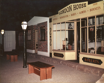
... a record of the curating work of Roy Harvey, a local historian ...This photograph is recorded as depicting a street of shops and London houses at Burke Museum in the 1990s. It features an indoor recreated historical streetscape of the 19th century. Within the shop window recreation are objects on display, including hats. The Street of Shops exhibition is still on display at Burke Museum and features objects collected in 1979 through the community by Roy Harvey (also author of Background to Beechworth from 1852), to provide insight into eras of the past. This exhibit displays a collection of over 30,000 items, many dating back over 150 years. The ‘street of shops’ tell the story of the changing town and its community.This photograph is of social significance to the Beechworth area and the Burke Museum as it depicts a still-exhibiting museum display that is of value to the community. The artefacts exhibited in the photograph all have a strong connection to the Beechworth area, having been donated by members of the local community, and are of special value to that community. It is also a record of the curating work of Roy Harvey, a local historian, author and museum curator, as well as a depiction of the curating and exhibition practices of the 1990s, when the photo was taken.This is a colour rectangular photograph printed on paper.Obverse: Est London House 1856 / mantles, manchester, robes, gowns, bonnets / rundle and roberts. Reverse: 53307street of shops, historical streetscape, recreated shops, roy harvey, museum exhibit, burke museum, beechworth, 19th century museum display, victorian artefacts, community, exhibition history, shop history, shop recreation, hats, bonnets, manchester, robes, gowns, rundle and roberts -
 The Beechworth Burke Museum
Geological specimen - Chalcopyrite
This specimen originated from Mount Lyell on the west coast of Tasmania, where a large group of open cut and underground copper-silver-gold mines began operating in 1883. Between 1893-1994, the Mt Lyell Mining and Railway Company were responsible for operations. The Mt Lyell copper-gold mines produce some excellent crystallised specimens of chalcopyrite and other minerals. The deposits are generally considered to be of Cambrian volcanic origin, but there are indications of Devonian granitic influence on the ores, plus local remobilisation during Devonian deformation. Over 120 million tonnes of ore was produced from several workings, including the main Prince Lyell mine and the North Lyell mine, which was also of great importance. The Mount Lyell mines have a long history of human and environmental disasters, including the 1912 North Lyell fire that killed 42 miners, and two separate incidents in 2013 in which three people lost their lives. The environmental impacts from this complex of mines are extensive, with waste tailings and heavy metal contamination flowing directly into the King and Queen River catchments. In 1954, the eminent Australian historian, Geoffrey Blainey, published 'The Peaks of Lyell' which delves into the history of the 1912 North Mount Lyell Disaster.Chalcopyrite does not contain the most copper in its structure relative to other minerals, but it is the most important copper ore since it can be found in many localities and occurs in a variety of ore types. The brassy-yellow colours in Chalcopyrite mean it is often confused with pyrites and gold, leading to use of the term, "fool's gold." Chalcopyrite has been the primary ore of copper since smelting began five thousand years ago. This specimen is part of a larger collection of geological and mineral specimens collected from around Australia (and some parts of the world) and donated to the Burke Museum between 1868-1880. A large percentage of these specimens were collected in Victoria as part of the Geological Survey of Victoria that begun in 1852 (in response to the Gold Rush) to study and map the geology of Victoria. Collecting geological specimens was an important part of mapping and understanding the scientific makeup of the earth. Many of these specimens were sent to research and collecting organisations across Australia, including the Burke Museum, to educate and encourage further study.This hand sized solid mineral specimen has shades of brass-yellow with spots of iridescent green-black tarnish. Chalcopyrite is a copper iron sulphide mineral and a major ore of copper common in sulphide veins and disseminated in igneous rocks. Chalcopyrite has a hardness of 3.5-4 on the Mohs Scale. It is a member of the tetragonal crystal system and has metallic lustre and opaque transparency.burke museum, beechworth, indigo shire, beechworth museum, geology, geological specimen, chalcopyrite, copper pyrites, copper mining, tasmanian geology, mount lyell, mount lyell mines, fools gold, mohs scale, crystals, minerals, historical geological collection, victorian geological survey, a.r.c selwyn, gold rush, van diemans land -
 Orbost & District Historical Society
program, 1931
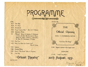
The official opening of the Obost Theatre was held on 20th August, 1931, opened by Hon. T. Paterson M.H.R. Thomas Paterson was Minister for Markets and Migration from June 1926 to January 1928. He was elected as the Country Party Member for Gippsland in 1922 and held the seat until he retired in 1943. In January 1928 his portfolio was changed to Minister for Markets and in December of that year it was again changed to Minister for Markets and Transport. Nance Gilbert was the sister of Mary Gilbert, Orbost teacher and historian. Nance Jenning was a professional golfer, daughter of Jonathon Gilbert and Annie Cameron.This item is reflective of local community events in the first half of the 20th century.A white, rectangular paper program with blak ink. It is for the official opening of the "Orbost Theatre".On front - "Nance Gilbert - Aged 6 years"orbost-theatre-program paterson-thomas -
 Orbost & District Historical Society
book, Barns of the Snowy River Orbost, 2006
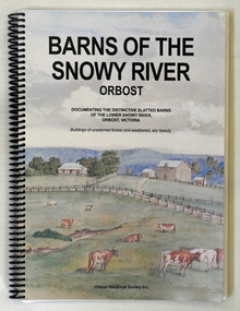
... gippsland This is a book written by a local historian containing ...This is a book written by a local historian containing historical information pertaining to Orbost and the surrounding district. A spiral bound book of 191pp. On the front and back covers are coloured print of the Morgan Barn c 1900, an original watercolour, artist unknown. The book documents the distinctive slatted barns of the lower Snowy River, Orbost, Victoria. The book was published by the Orbost Historical Society and was written by May Leatch and Ngaere Donald. It contains B/w photographs, drawings and stories of the barns and their histories.history-agriculture-orbost barns-slatted -
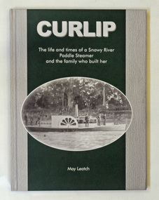 Orbost & District Historical Society
book, Curlip, November 2008
... was written in Orbost by a local historian. p.s.curlip paddle-steamers ...This book was written at the same time as the replica of the PS Curlip was being built in Orbost. The great grandson of Samuel Richardson is Gil Richardson who lives in Bete Bolong just outside Orbost. Gil and Heather Richards presented the author, May Leatch with a box of old diaries written by Sam Richardson and Sam's sons, Alan and Frank. Using these as the basis of the story, May wrote the full story of the Curlip and the Richardson family.This book about a local icon and a local family was written in Orbost by a local historian.A green and grey covered book titled, CURLIP The life and times of a Snowy River Paddle Steamer and the family who built her. On the front cover is a black and white photograph of the PS Curlip taken shortly after its launch in 1890. On the back cover is a black and white photograph of phragmites on the Snowy River floodplain. The book traces the history of the Richardson family from Godalming, Surrey, England to Orbost, East Gippsland, Victoria in Australia. It contains b/w photographs, diary extracts and newspaper extracts. The book was written by May Leatch.p.s.curlip paddle-steamers orbost richardson-family richardson-samuel -
 Flagstaff Hill Maritime Museum and Village
Book, The Discovery of Australia
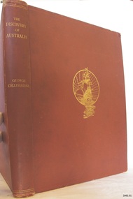
The Osburne Group was was three people, headed by Warrnambool Lawyer Dan Madden, who in the 1980’s republished a few local historical books. Collingridge’s (1847-1929) book ‘The Discovery of Australia’ was a work which supported the ‘legend’ of a Portuguese voyage of exploration, which led to the loss of one of its ships in 1522, believed to be the Mahogany Ship, on the coast south of Tower Hill. Hence European charting of the east coast of Australia centuries before Captain Cook, which the British historians viewed almost as heresy. TheOsburne Group acquired copies of Collingridge from the publisher, and saw that they were made available as a historical record supporting the research of Ken McIntyre, who in 1981 published separately a book called ‘The Secret Discovery of Australia’. The first book by the Osburne Group was republished in facsimile. It was the ‘History of Warrnambool’, collated and printed by Richard Osburne in 1887 after he had sold his newspaper the Warrnambool Examiner to Fairfax, which took up the name of Warrnambool Standard. Hence the name Osburne. Other books reproduced in facsimile form include ‘By These We Flourish’ by C.E.Sayers, and ‘Warrnambool Past and Present by Edward Vidler.The Discovery of Australia Author: George Collongridge Publisher: Kayes Brothers Date 1895 Has a sticker on front loose end page stating " Presented to Flagstaff Hill by Osburne Group"flagstaff hill, warrnambool, shipwrecked-coast, flagstaff-hill, flagstaff-hill-maritime-museum, maritime-museum, shipwreck-coast, flagstaff-hill-maritime-village, the discovery of australia, book, george collingridge, osburne group -
 Warrnambool and District Historical Society Inc.
Documents, Sheet Music Back to Warrnambool Song, 1930
This is the original manuscript for the song ‘Back to Warrnambool’, composed for the ‘Back To’ celebrations in Warrnambool in 1930 and reprinted for the ‘Back To’ celebrations in 1934. The song, described as a ‘souvenir foxtrot’ was written by Reginald Stoneham, a professional musician who was engaged to write the song. Reginald Stoneham (1879-1942) was a composer who was Australia’s leading exponent of jazz and ragtime piano styles in the first decades of the 20th century. He composed many tunes for anniversaries and celebrations in country towns and cities in Victoria. The original ‘Back to Warrnambool’ music was given to Henri Worland, the Town Clerk of Warrnambool in 1930 and handed over to the Warrnambool and District Historical Society by Keith Arnel, the Town Clerk in 1973. Note that the original song was ‘Respectfully dedicated to the Pioneers of Warrnambool’. This dedication, for some reason, was not printed on the music issued in the ‘Back To’ programs of either 1930 or 1934. This is a significant item as the song ‘Back to Warrnambool’ has great historical significance as it was popular in Warrnambool in the 1930s and 40s and is still played and sung occasionally today. It is one of the two local songs about Warrnambool composed by Reginald Stoneham. The other is the Warrnambool Waltz Song. It is of interest to historians and researchers to have the original music.This is the original handwritten manuscript of the song, ‘Back to Warrnambool’. There are two pages of pre-ruled music score papers, filled in on both sides of the paper. The paper is marked ‘Boomerang Brand No2’. The musical notes and the words of the song are in black ink. The name of the song is outlined in red ink. The first page has the heading ‘Souvenir Foxtrot Song, Back to Warrnambool, Words and Music composed by Reginald Stoneham, 1930, Respectfully dedicated to the Pioneers of Warrnambool’. The last page has the signature of Reginald Stoneham. The first page has the signature of Henri Worland. warrnambool, reginald stoneham, back to warrnambool -
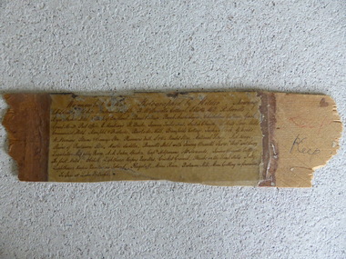 Warrnambool and District Historical Society Inc.
Frame Fragment, Frame Fragment from 1860 J Wilder, Late 19th century
Joseph Wilder, a professional photographer, came to Warrnambool in 1860 and took a series of photographs, two of which survive today. One was of the local Volunteer Corps and the other was a series of photographs taken from Cannon Hill showing Merri Street and the town and buildings beyond. It seems that copies of these last-mentioned photographs were framed to produce a large panoramic view of 1860 Warrnambool and one of these was given to the old Warrnambool Museum in the 1880s by James Astley Bromfield. He had established a chemist’s shop in Warrnambool in 1854 and showed his interest in the history of the young town by producing a map in 1856 showing the first landowners, a seminal resource today for historians. He again demonstrated this interest when he included the names of the people and places in the 1860 photograph he gave to the museum in the 1880s. The frame fragment was found amongst the collection of items from the old Museum at Flagstaff Hill Maritime Museum and brought to the Historical Society to accompany the original series of photographs. Bromfield went to live in Melbourne in the 1880s. It is presumed that the plastic cover has been placed on the frame fragment at a much later date than the 1880s.This frame fragment is interesting and very important for several reasons:- 1. It is one demonstration of the interest that James Astley Bromfield had in local history 2. It came from the old Warrnambool Museum and shows how that institution kept items of historical interest 3. It gives us the names of the people and places in the Joseph Wilder photographs of 1860 that placed together form a panorama that reveals what a major section of Warrnambool looked like only 13 years after its foundation. The list enables us to correctly identify the early places and people and so is invaluable for research purposes 4. It links a Museum exhibit of the 1880s with the original 1860 photographs which are held by the Historical Society This is a piece of wood broken from a frame containing a photograph. It has jagged edges. It contains the list of people and places depicted in the Joseph Wilder panorama photograph of Warrnambool in 1860. The list is handwritten in ink on paper which has been attached to the frame with a piece of plastic. Warrnambool in 1860 Photographed by Wilder. Showing children of the late Andrew Semple etc In red pencil – ‘Keep’, in ink, ‘Keep’ On separate piece of paper - Presented to Warrnambool Mechanics’ Muzeum by James Astley Bromfield, August 3rd 1886 joseph wilder 1860, panorama of warrnambool -
 Kiewa Valley Historical Society
Book - Mt Beauty Voters' Roll, Shire of Bright - Voters' Roll 1979 - Mt Beauty Riding, 1979
Electoral roles list people who are registered and eligible to vote at federal, state, territory and local government elections and referenda. Prior to 1990 the rolls list voters in alphabetical order by surname and first names within each Sub-division of an electoral Division of each State or Territory. The roll is useful and interesting for family historians and the study of demographics.Electoral rolls help to locate the residential address of a person in a particular year or over a period of years. They can be used as a substitute for census records for family historians and the history of a particular place, in this case Mt Beauty. Alex McCullough was a resident of Mt Beauty and Councillor in the Bright Shire. 40 pages of firm blue paper with black typed print on one side only in 'landscape' format. Held by three staples. Each page has columns - numbered 1 to 656; Surnames in alphabetical order; Given names; Occupation; Includes L = 'land'; Address followed by Lot number in the Parish of WermatongOn the cover, top right hand corner "Cr McCullough"shire of bright; mt beauty riding; voters roll; parish of wermatong; alex mccullough -
 Kiewa Valley Historical Society
Book - Kiewa Voters' Roll, Shire of Bright - Voters' Roll 1979 - Kiewa Riding, 1979
Electoral rolls list people who are registered and eligible to vote at federal, state, territory & local government elections and referenda. Prior to 1990 the rolls list voters in alphabetical order by surnames & first names within each Sub division of an electoral division of each State or Territory. The roll is useful & interesting for family historians and the study of demographics. Alex McCullough lived in the Shire of Bright and was on its Council. Electoral roles help to locate the residential address of a person in a particular year or over a period of years. They can be used as a substitute for census records for family historians and the history of a particular place in this case the Kiewa Valley - Tawonga and Tawonga South.Approx. 60 pages of firm yellow paper with black typed print on one side only in 'landscape' format. Held by three staples. Each page has column - numbered 1 to 943; Surnames in alphabetical order; Given names; Occupation; includes L (=land). Address followed by Lot number and parish. Includes Tawonga and Tawonga SouthOn the cover on the right hand side handwritten and difficult to read - "Jack? / Indi / Benambra / Nth Eastern / Division? of Dawson / 123 Victoria Rd. / Melbourne 3000"shire of bright; kiewa riding; voters roll; alex mccullough; tawonga; tawonga south -
 Kiewa Valley Historical Society
Papers - Mt Beauty Voters' Roll, Shire of Bright - Voters' Roll 1985 - Mt Beauty, 4th July 1985
Electoral rolls list people who are registered and eligible to vote at federal, state, territory and local government elections and referenda. Prior to 1990 the rolls list voters in alphabetical order by surnames and first names within each Subdivision of an electoral division of each State or Territory. The roll is useful & interesting for family historians and the study of demographics. Alex McCullough lived in Mt Beauty and was a councillor for the Shire of Bright.Electoral Rolls help to locate the residential address of a person in a particular year or over a period of years. They can be used as a substitute for census records for family historians and the history of a particular place - in this case Mt Beauty.9 pages of firm blue paper with black typed print on one side only. Held at the top left corner with one staple. Each page has columns with 100 people listed up to 864 on page 9. surnames are in alphabetical order followed by given names and then addresses.shire of bright; voters' roll; alex mccullough; mt beauty -
 Kiewa Valley Historical Society
Papers - Kiewa Riding Voters' Roll, Shire of Bright - Voters'Rolls 1985 (May and June) - Kiewa Riding, 4th July 1985
Electoral rolls list people who are registered & eligible to vote at federal, state, territory & local government elections & referenda. Prior to 1990 the rolls list voters in alphabetical order by surname & first names within each subdivision of an electoral division of each state or territory. The roll is useful and interesting for family historians & the study of demographics. Alex McCullough lived in Mt Beauty and was a councillor for the Shire of Bright.Electoral Rolls help to locate the residential address of a person in a particular year or over a period of years. They can be used as a substitute for census records for family historians and the history of a particular place - in this case Tawonga, Tawonga South, Falls CreekMay 1985 is 7 pages; June 1985 is 9 pages of firm yellow paper with black typed print on one side only. Held by one staple at the top left hand corner. The May 1985 - Each page has columns with 100 people listed up to 628 on page 7. Surnames are in alphabetical order followed by given names and then address. June 1985 Voters Roll (Non resident) is created from Property & lists Voters No. (up to 406) Property No. Name (alphabetical) & address and are non resident voters.shire of bright; voters' rolls; kiewa riding; tawonga; tawonga south; alex mccullough; falls creek -
 Warrnambool and District Historical Society Inc.
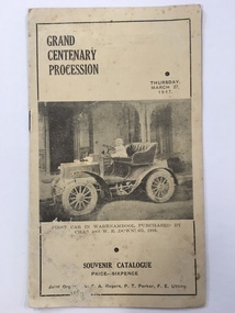
Booklet, Grand Centenary process, 1947
This is a program of the Centenary Procession that took place in Warrnambool in 1947 to celebrate the 100th anniversary of the city’s founding in 1847. It was originally intended to celebrate the 100th anniversary in 1940 but these celebrations were postponed because of World War Two. In 1947 centenary celebrations were held but on a less lavish style. 1947 was a more appropriate year as 1847 was the year of the first land sales for Warrnambool and the arrival of the first European settlers in the town. The 1947 celebrations included a Grand Procession which was estimated to have been watched by 20,000 people. A similar number saw the bonfire and fireworks display in Albert Park the same evening. The celebrations lasted a week and included a choral thanksgiving festival in the Botanic Gardens, a massed band display and a ‘Warrnambool Can Make It’ exhibition of local manufactures. The well-known historian and Town Clerk at the time, Henri Worland took a prominent role in the organizing of the celebrations. This little booklet is of considerable importance because it contains a short description of the floats and the names of those connected with the various floats of the Warrnambool Centenary Procession of 1947. It not only gives us a better idea of what and who were in the procession but it now enables us to better label the many photographs we have of this procession and to identify the people in the photographs. The program is a valuable source of information for historians. It also is a good example of the type of celebratory procession that was popular 70 years ago. This is a paper program of the Warrnambool 1947 Centenary procession. It has four pages and a buff-coloured cover. The front cover has a sepia-toned photograph of the first car purchased in Warrnambool (1906) and on the back cover there is an advertisement for Lane’s Bus Services. The inside front cover has an advertisement for Guyett and Sons Furniture Store and there are other advertisements throughout the pages. The printed text on buff-coloured paper gives details of the 29 floats in the ‘Mechanized’ Section and of the 27 floats in the ‘Back to the Horse Pageant’ Section. The pages were stapled but the staples have been removed. There has been some silverfish damage. Front Cover: ‘Grand Centenary Procession, Thursday, March 27, 1947, Souvenir Catalogue, Price Sixpence, Joint Organisers, C.A.Rogers, P.T.Parker, F.E.Utting’. warrnambool centenary, 1947 henri worland -
 Warrnambool and District Historical Society Inc.
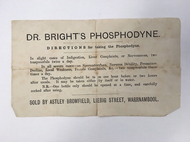
Document, Docket Dr Bright's Phosphodyne, Mid 19th century
This label accompanied a bottle of Dr Bright’s Phosphodyne. It was a form of medicine also known as ozonic oxygen which was developed and patented in 1869 by Dr Charles Bright, a 19th century Resident Surgeon at St Mary’s Hospital London, The medicine claimed to ease ‘indigestion, liver complaints, nervous debility, female complaints, premature decline, local weakness and spermatorrhea’. It was widely sold by chemists throughout Australia in the 19th century and in this case was supplied by the Warrnambool chemist, James Astley Bromfield. He was a significant person in Warrnambool’s history as he produced the 1856 map of the Warrnambool district showing all the original landholders, a seminal resource for historians today. Bromfield had a chemist shop in Warrnambool from 1854 to the late 1880s, initially in Timor Street and then in Liebig Street (number 80 and later number 78). Bromfield was very active in local community affairs. This label is of considerable interest as it shows the use in the 19th century of medicine that today would be labelled ‘quack’. It is of particular interest as it was supplied by James Astley Bromfield’s chemist shop and he is an important early identity in Warrnambool, involved in many activities in the town. He was a Justice of the Peace, a Trustee of the Savings Bank, Chairman of the Western Steam Navigation Company, a Director of the Gasworks and on the committees of the Harbour Committee, the Fire Brigade and the Anglers Protection Society. He was a Warrnambool Councillor (1858-60; 1865-1870) and a Shire Councillor (1875-1883). This is a sheet of paper that accompanied a bottle of Dr Brights’ Phosphodyne medicine. It is buff-coloured with black printed material. It is in two pieces and dog-eared at the edges.warrnambool, dr bright's phosphodyne, james bromfield chemist, warrnambool chemists -
 Warrnambool and District Historical Society Inc.
Book, Australian Military Forces, Notes on Horse Management, 1926
... interest to local historians as both the Mounted Rifles ...Australian Military Forces Book on Horse ManagementThis is a small book of 73 pages. It has a buff-coloured cover with black printing on the front cover. The pages contain printed text with one illustration. The pages are bound with two staplesnon-fictionAustralian Military Forces Book on Horse Managementaustralian military mounted units, horse management, lighthorse, australian lighthorse -
 Warrnambool and District Historical Society Inc.
Booklet - Tourism Booklet, A.H.Powell (Powell Print Ballarat), Warrnambool - The Blue Ribbon Pleasure Resort, 1913
This is a booklet by the Warrnambool Tourist Publication 1913This is a booklet of 62 pages. It has a white cover with red and blue printing on the front cover and a blue-toned photograph on the back cover. The pages contain printed text, advertisements and black and white photographs. The pages are stapled.non-fiction This is a booklet by the Warrnambool Tourist Publication 1913warrnambool tourism, visit to warrnambool 1915 by george mcdonald -
 Warrnambool and District Historical Society Inc.
Card, Hallmark, On your retirement, 1968
This card was presented to Bruce Morris on his retirement as editor of the Warrnambool Standard newspaper in 1968. The signatures on the card are those people who worked closely with him (the editorial staff?) on the newspaper. Bruce Morris (1903-1986) was the grandson of George Lance, well-known in Warrnambool in the 19th century as an artist, writer and musician who was deeply involved in the establishment of the Warrnambool Art Gallery. Bruce Morris was the staff training superintendent at Myer in Melbourne during the 30s and 40s. In 1946 he became the editor of the Warrnambool Standard and remained there until 1968. For 22 years he observed and recorded the events that affected the lives of the local people. He was noted for his historical articles (mostly with the initials BBM) and continued to write these articles for the Standard until the year he died. This card is of interest as a memento of Bruce Morris, one of Warrnambool’s important historians. This is a buff-colured card folded over to make a leaflet with a sheet of white paper folded over in the middle of the leaflet. The front cover has gold ornamentation and gold printing. There are a printing of a verse and eleven signatures in blue on the inside paper. ‘Ron Oakley, E. Fitzhenry, Eileen T, Horne, Don Burnett, Mac Jeffers, Peter Robertson, Terry Daffy, David Ferguson, Bruce Johnson, Ron Armstrong, Jim Ewing.’brue morris, warrnambool, warrnambool standard editors, history of warrnambool -
 Warrnambool and District Historical Society Inc.
Booklet, Port Fairy, Early to mid 20th century
This is a typed copy of William Earle’s History of Port Fairy written in 1896. The history is of interest to researchers and the information contained in it has been updated and extended by historians in recent times. William Earle, a printer with a business in Port Fairy came to Australia with his parents, William and Mary, in 1854. He was a Councillor and Mayor and was heavily involved in local community affairs. He died in 1902 at the age of 51. His 1896 history won a prize in a local Industrial Exhibition and was widely acknowledged as an important primary source of early Port Fairy history. This booklet is of minor interest as it is a copy of a 19th century Port Fairy history book and is not a rare item. It is retained as it came from the Baulch collection of documents and belonged to David Baulch of Koonongal Estate, HwakesdaleThis is a booklet of 59 pages of typed material bound into a brown cardboard cover with metal screws. The pages are typed on one side only and have a black border around all sides.David Baulch Koonongal Estate Hawkesdale 3287baulch family, dunmore and rose park, history of warrnambool -
 Warrnambool and District Historical Society Inc.
Publication, David Pitt and Perce Hampshire, Early Otway residents, 1989
This booklet has been collated by a committee of Otway Ranges residents in 1989. It contains historical information on 32 pioneer families in the Otways region. The material has been provided by the members of the families. This book is of interest as it contains short histories of some pioneer families in the Otway Ranges and will therefore be of particular use to historians.This is a soft-cover booklet of 35 pages. It is bound with metal staples. The booklet has a yellow cover with black printing. The booklet contains details on the lives of some Otway Ranges pioneer families and has been typed and produced by a local committee.otway ranges, victoria, pioneers of the otway ranges