Showing 212 items matching "moyne"
-
 Flagstaff Hill Maritime Museum and Village
Photograph - S. S. Casino, Early 19th century
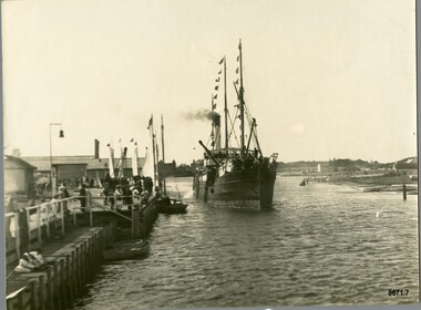
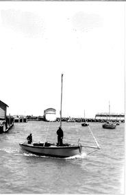
This photograph was one of ten photographs donated to Flagstaff Hill Maritime Museum and Village by Fred Trewartha. Frederick John Fox Trewartha (Fred) was a well-known Warrnambool businessman. He was born in Beeac near Geelong in 1920 and came to Warrnambool with his family as a very young child. He was apprenticed to his father John, as a saddler and later opened his own shop on Raglan Parade. He then moved into working with tarpaulins and canvases for the trucking industry. Fred was keenly interested in photography (and was a member of the Warrnambool Cine Club), yachting and boat building. He kept his yacht moored at Port Fairy for many years and participated in sailing events locally and interstate. He also built boats with his sons. He had the opportunity to meet many older sailors and it's thought this photo (and others in the set) may have been given to him by one of these men. Fred Trewartha died in 2016 in Warrnambool. The S.S. Casino was a passenger and freight steamer built in Dundee, Scotland, in 1882 for the Newcastle and Hunter River Steam Navigation Company of N.S.W. She weighed 425 tons gross with a length of 160.4 feet, beam of 24.1 feet and a depth of 10.2 feet. She had saloon accommodation for 35 people, a fore cabin for 25 more people, and she carried 300 tons of cargo. While on her delivery journey on May 30th 1882, the S.S. Casino called in at the Port of Warrnambool for coal, narrowly escaping going ashore in gale force winds due to the quick action of the pilot. At that time, still at anchor, she impressed the directors of the Belfast and Koroit Steam Navigation Company so much that they bought her immediately; she was ideal for trade along the West Coast of Victoria. (The Belfast and Koroit Steam Navigation Company was first managed by Messers. Saltau and Osburne and after the passing of Mr. Osburne, by produce merchants Messers H. Sautau and Sons, who had a hay and corn store and shipping agency on the corner of Liebig and Koroit Streets in Warrnambool. ) The S.S. Casino became “the most famous steamer to operate in Victorian waters along the West Coast” by author Jack Loney. Captain Boyd was her first Master, followed by Captain Chapman, who stayed with her from 1890 until 1924. Captain W. Robertson followed for a short term, and then Captain Middleton then took command from 1925 - 1932. An article published on Monday 11th June 1932 in The Sun News Pictorial (Melbourne) giving a detailed history of S. S. Casino said "owned by Port Fairy interests, she was an integral part of the town's development ... for a long time, her arrival in Port Fairy was an event, the townspeople going down to the wharf to see her come in". It also said "Except when the weather was bad, the Casino hugged the coast on her trips and passengers obtained wonderful views of the sandstone terraces and caves. A little time ago every member of her regular crew except one, was a Scotsman." This particular photograph of the S.S. Casino shows it decorated with numerous flags in "holiday rigging". During the years between 1884 and 1915, the Casino would take locals and holiday makers on excursions around the Port Fairy Bay. Local towns such as Terang, Penshurst and Mortlake held their Picnic Days in Port Fairy and excursions on the Casino would be available for them and in 1906 Terang and District Schools held an excursion to Port Fairy (where the Casino was organised to provide a series of trips around the Bay.) In 1916 new regulations introduced by the Marine Board requiring the Casino to carry enough lifebelts for every passenger on board, prevented the steamer from making trips around the Bay on excursion days. The S.S. Casino had several mishaps during her life. One was on 3rd January 1898 when she collided with the S.S. Flinders in Apollo Bay with minor damage. Another was on 24th October 1924 when she grounded on a reef at Point Hawdon near Grey River and most of her cargo (of Christmas goods) had to be dumped into the sea. Then in February 1929 she was ‘holed’ when she struck a submerged object as she entered Lady Bay, Warrnambool. In the years following the turn of the century, the S.S. Casino remained the only regular trader with normal passenger accommodation along the West Coast. From 1882 she had made at least 2,500 voyages on the one run. On the morning of 10th July 1932, after attempting to berth at Apollo Bay jetty in heavy seas, Captain Middleton decided to take her out into the bay and wait until the seas abated. It was not realised that the anchor used to steady her as she manoeuvred to her berth had pierced her hull. She put about and headed for the beach but sank. Captain Middleton and nine others lost their lives; nine people were rescued including the two female passengers. Captain Middleton had been in charge of the S.S. Casino for seven years. He was the first ship’s Master to lose his life in a shipwreck in the West Coast trade. In June 1932, the directors of the Belfast and Koroit Steam Navigation Company had proposed to celebrate the completion of fifty years of trading by the steamer Casino in August, but tragically the Casino was wrecked only one month later (and "was only one month off completing its fifty years of valuable service between Melbourne and Portland.") Flagstaff Hill’s collection has a photograph of a portrait of Captain Chapman, a ship model of the S.S. Casino that shows both forms of power under which she sailed, steam and sail. The ship is painted green and flies three flags. The inscription across the case of the ship model, incorrectly dated, tells the sad story of the wreck of the ship and the loss of lives on July 10th 1932 at Apollo Bay. A print in the Collection shows S.S. Casino underway in the heavy sea off Point Lonsdale, another two photographs show her at the Port of Warrnambool, leaving from the Breakwater in Lady Bay and another identifies the S.S. Casino as a ship from the Belfast and Koroit Steam Navigation Company. (Belfast is the original name for the township of Port Fairy).This photograph is significant because of its association with the coastal trader S.S. Casino and its significance to trade along Victoria's West Coast in the late 19th and early 20th centuries. The wreck of the S.S. Casino is considered an important part of Victorian and Australian cultural heritage and as such has been declared and protected as an Historic Shipwreck under State and Commonwealth Law in the Commonwealth Historic Shipwrecks Act (1976).A black and white photograph showing a small steamer with decorative flags on both masts, coming into up a river towards a pier where a small crowd is waiting. The pier on the left of the photograph has several buildings and a bell on it. Three small boats are tied up to the dock. Low lying land with several buildings scattered on it can be seen on the right hand side. On the back of the photograph are handwritten labels. One is printed in dark blue ink and one is written in cursive writing in biro. There is also the number 6944 stamped in the centre of the photograph.Back - Donors name, address and telephone number 6944 "CASINO IN HOLIDAY RIG" "at Port Fairy"flagstaff hill maritime museum and village, warrnambool, great ocean road, shipwreck coast, s. s. casino, steamer casino, casino, port fairy, captain chapman, belfast and koroit steam navigation company, saltau and osburne, captain middleton, apollo bay, apollo bay shipwreck, lady bay -
 Ballarat Heritage Services
Photograph - Digital photographs, L.J. Gervasoni, Infant Jesus Catholic Church Koroit, 2011-2016
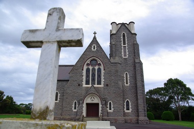
http://vhd.heritagecouncil.vic.gov.au/places/69285 " ... the foundation-stone of the new church at Koroit was laid by Bishop Goold on New Year's Day, 1867. It was said of Fr. Parle that his one. fault was "extravagant ideas of church building," and to his vision must be attributed what was called at the time "the most magnificent and costly ecclesiastical building in the Western District." Altogether about £6000 was spent on the Koroit church, a large sum in those days. It entailed much delay while the money was being collected, and Fr. Parle did not live to see the completion of the great work he had undertaken. .. " (The Advocate, 13 August 1947.) Digital images of a funeral congregation at Infant Jesus Catholic Church in Koroit, Victoria. church, catholic, koroit, infant jesus, exterior, presbytery, bluestone -
 Ballarat Heritage Services
Digital photographs, L.J. Gervasoni, Infant Jesus Catholic Church Koroit interior, 2011-2016
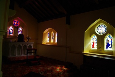
http://vhd.heritagecouncil.vic.gov.au/places/69285 " ... the foundation-stone of the new church at Koroit was laid by Bishop Goold on New Year's Day, 1867. It was said of Fr. Parle that his one. fault was "extravagant ideas of church building," and to his vision must be attributed what was called at the time "the most magnificent and costly ecclesiastical building in the Western District." Altogether about £6000 was spent on the Koroit church, a large sum in those days. It entailed much delay while the money was being collected, and Fr. Parle did not live to see the completion of the great work he had undertaken. .. " (The Advocate, 13 August 1947.)Digital images of the interior of the Catholic church at Koroitchurch, catholic, koroit, infant jesus, presbytery, bluestone, interior, religion -
 Federation University Historical Collection
Certificate, Lisa Lodge Certificate of Appreciation, 2003
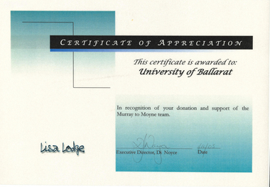
The Australasian Institute of Mining and Metallurgy was founded in 1893.Lisa Lodge Certificate of Appreciation awarded to the University of Ballarat in recognition of support of the Murray to Moyne team.university of ballarat, lisa lodge, murray to moyne, ceretificate, di noyce -
 Port Fairy Historical Society Museum and Archives
Photograph
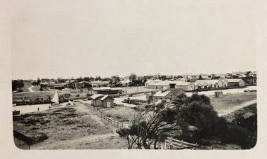
aerial view over Port Fairy looking across the river at the railway line and butter factoryBlack and white aerial photograph of Port Fairy looking across the Moyne river and railway stationaerial, railway, river, town -
 Port Fairy Historical Society Museum and Archives
Photograph - newspaper photograph
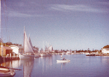
Moyne river moyne river, boats, sails -
 Wannon Water
Ornament
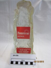
2002 Powercor Warrnambool- Moyne Business Achievement Awards South West Water's contribution to the region's environmental health was recognised at the 2002 Powercor Warrnambool-Moyne Business Achievement Awards.Clear resin ornamentPowercor Australia Environmental contribution South West Water Authority Deakin Universityawards, south west water authority -
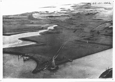
 Port Fairy Historical Society Museum and Archives
Photograph, R.W.Golding, 1925
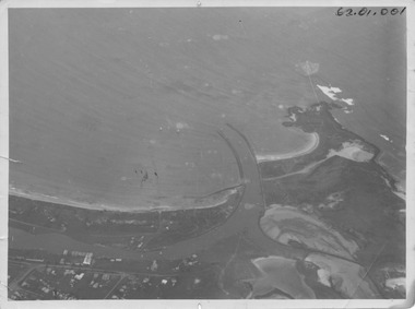
taken in 1925 by W Golding Aerial-Port Fairy Harbour 1925Black and White aerial view of Port Fairy ‘s waterways62.01.001 on front of photograph - on the back-Port Fairy Moyne River Entrance W Goldingaerial view, harbour, griffiths island, w.golding, training walls -
Port Fairy Historical Society Museum and Archives
Photograph
Moyne Bridge & Gardens 1904/06Black and white Photograph glued to cardboard Bridge and Gardens Port Fairy R. Scott photomoyne bridge, gardens, traffic, griffith street -
 Port Fairy Historical Society Museum and Archives
Photograph
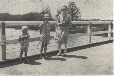
Family standing on Moyne River bridgeBlack and white family photograph bridge, moyne river, famiily, children, mother, traffic, car -
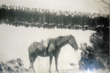 Ballarat Heritage Services
Photograph - Black and White Photograph, Tom Fitzgerald at Tarrone Starion
Torrone Station was on the Moyne River near Koroit. A black and white photograph with Tom Fitzgerald and his horse at Torrone Station. Many rabbits hang in the background.tom fitzgerald, torrone station -
 Port Fairy Historical Society Museum and Archives
Photograph
Martin's Point from battery hill side of Moyne riverColoured photograph of Martins Point with people fishing on the bankmartins point, moyne river, fence, signal -
 Port Fairy Historical Society Museum and Archives
Photograph, c. 1925
Black and white aerial of Martins Point Moyne River showing dredge. The original signed by R. W. Golding.Black and white landscapelocal history, photography, photographs, slides, film, aerial, martins point, moyne river, dredge -
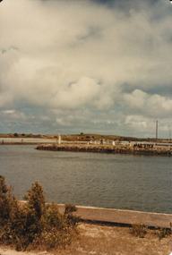
Glenelg Shire Council Cultural Collection
Map - Map - RACV Road Map, 1970s
RACV road map, Portland district, Port MacDonnell to Warrnambool. Large coloured map of Portland District, small maps of Portland, Mt Gambier, Hamilton, Mount Eccles National Park, Coonawarra Wineries. When folded, black and white phot of child fishing on jetty on Moyne River, Port Fairy on coverroad touring, racv, map -
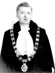 Port Fairy Historical Society Museum and Archives
Photograph, Brophy, John Sarsfield Mayor of Borough of Port Fairy 1956 1957 1975 1976 1977 1978
John Sarsfield Brophy Mayor 1956 1957 1975 1976 1977 1978 CEO of Port Fairy Hospital Greatly involved in the Moyneyana Festival which raises money for the Port Fairy Hospital or Moyne Health Services as it is now known.Black & white portrait of John Brophy in mayoral robes, jabot and gold chainbelfast, mayor, portrait, government, shire, council, municipal, local-government -
 Queenscliffe Maritime Museum
Photograph - Black & white photograph of the Couta boat "Lila" under way, Photographer unknown, Photographs
Photos of the LILARealism, historicalBlack & white photograph of the C Jurgens' Couta boat "LILA" under way at Fisherman's Pier, QueenscliffeOn the reverse - "P1A48 - Boat in front C Jurgens LILA at Fisherman's Pier - couta boat (on R) MOYNE - built W Blunt, Geelong owner Gus Johnson from B Richards" -
 Port Fairy Historical Society Museum and Archives
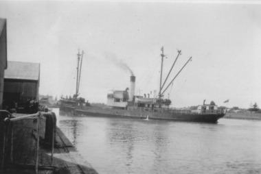
Photograph, TSS Coramba
Used primarily for shipping freight between Port Fairy and Melbourne, the Coramba was lost off Phillip Island during a storm on 30th November 1934. Her location was not discovered until 29th May 2011. This photograph is unique because it shows the ship using the turning basin in the Moyne River.B&W photograph ship, boat, sea, river -
 Warrnambool and District Historical Society Inc.
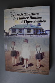
Book, From tents & tin huts to timber houses & tiger snakes: Soldier Settler stories from Hawkesdale, Macarthur & Penshurst, April 2021
Soldier settler family stories from the Hawkesdale, Macarthur and Penshurst areas.A4 soft bound book with photograph of timber house in country location with post and wire fence and three children walking towards the house; a girl in light-coloured dress carrying a school case is in the middle with a boy in crossover top shorts with school bag over their right shoulders on either side of her. Text is black.non-fictionSoldier settler family stories from the Hawkesdale, Macarthur and Penshurst areas.military history, soldier settlement wwii, hawkesdale, macarthur, penshurst, eugene von guerard, robert dowling, first australians -
 Warrnambool and District Historical Society Inc.
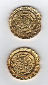
Medallions, Borough of Koroit, 1985
These medals were produced in 1985 to denote the closing of the Koroit Borough. Koroit is 18 kilometres north west of Warrnambool and the Borough of Koroit, established in 1870, covered 23.07 square kilometres. In 1985 the Borough of Koroit was incorporated into the Shire of Warrnambool as the Koroit Riding. In 1994 the Shire of Warrnambool ceased to exist and Koroit became part of the Shire of Moyne.These medals are interesting mementoes of the Borough of Koroit, a municipal authority that no longer exists.These identical gold coloured metal, almost circular, medallions feature a coat of arms with indistinguishable text and emblems , a second text and a wreath of laurel around the rim. The edge is notched and indented at the base.. The reverse side has text on a circular centre with the back of the laurel wreath surrounding it. Obverse BOROUGH OF KOROIT1870 Reverse 1870 1985koroit borough, warrnambool history -
Glenelg Shire Council Cultural Collection
Functional object - Lifebuoy, n.d
City of Portland Collection|Kurtze Museum|19/4/2000. The lifebuoy came from the S S Casino. A popular cargo ship, the Casino was a regular sight on the Moyne river and along the coast. The ship was an integral part of coastal life until she was shipwrecked in the 1930's, and objects from the Casino can now be found in collections from across the region.S S CasinoCanvas covered ring of bouyant material (possibly cork), with rope loop fixed to 4 ponts on the outside edge. Inscription "S.S. CASINO" centre top, "PORT FAIRY" at centre bottom, a flag painted centre left and centre right.Front: Centre top "S. S. CASINO"|Centre bottom "PORT FAIRY"|flag on centre left and centre rightss casino, port fairy, cargo ship, lifebuoy -
 Kew Historical Society Inc
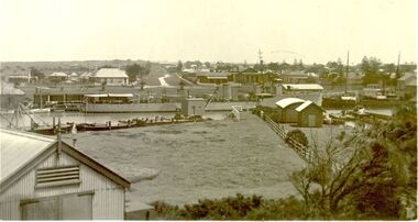
Photograph - Wharves and harbour on the Moyne River at Port Fairy, c.1926
Henry Beater Christian (1886-1962) , was a descendant of one of the earliest settler families in Kew. Employed at the Kew Asylum as a 'public servant', he was a skilled amateur photographer, photographing numerous scenes in Kew and on his travels around Victoria. The majority of his photographs date from 1916 to 1929. His finest photographs are housed in two photograph albums. Digital copy of a photograph from page 24 of the 47-page photograph album containing 261 gelatinous silver images, loaned by Diane Washfold with permission given to digitise and hold a copy in our collection. In what would appear to be one of his rare trips to coastal Victoria, Henry Christian took this photo of the wharves and harbour on the Moyne River at Port Fairy in c.1926. The photograph shows the buildings along the river and parts of the township in the distance. henry beater christian (1886-1962), landscape photography, christian-washfold collection, photograph albums, moyne river, port fairy (vic.) -
 Warrnambool and District Historical Society Inc.
Stamp, W'bool Co.op Commons Seal, 1945
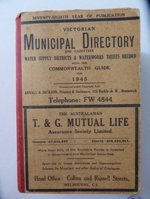
This is a Victorian Municipal Directory for 1945, containing general information on all municipalities in Victoria, a Gazeteer, a Commonwealth Guide and a Water Supply Record. Municipal Directories were published annually in Victoria from 1867 on. This directory came from the Shire of Mortlake which was established in 1864 when it had an area of 2137 square kilometres. The Shire of Mortlake was abolished in 1994 and merged with other neighbouring shires to form the present day Shire of Moyne. This book is very useful to researchers as it contains much information on the City, Borough and Shire structures, the Council employees and Government employees of all the municipalities. It has, therefore, important local information on Warrnambool and the surrounding areas in 1945. This is a soft cover book of 1114 pages. It has a buff- coloured cover with red binding on the spine. The printed material on the covers is printed in black. It has a blue stamp of the Shire of Mortlake on several pages. The book contains several advertisements for Melbourne businesses. ‘Shire of Mortlake’ shire of mortlake, local government in victoria, warrnambool history -
 Port Fairy Historical Society Museum and Archives
Photograph, 1921
HMAS Huon berthed at the wharf in Port Fairy Nov 1921. HMAS Huon (D50), named after the Huon River, was a River-class torpedo-boat destroyer of the Royal Australian Navy (RAN). Originally to be named after the River Derwent, the ship was renamed before her 1914 launch because of a naming conflict with a Royal Navy vessel. Huon was commissioned into the RAN in late 1915, and after completion was deployed to the Far East. In mid-1917, Huon and her five sister ships were transferred to the Mediterranean. Huon served as a convoy escort and anti-submarine patrol ship until a collision with sister ship HMAS Yarra in August 1918 saw Huon drydocked for the rest of World War I. After a refit in England, Huon returned to Australia in 1919. The destroyer spent several periods alternating between commissioned and reserve status over the next nine years, with the last three spent as a reservist training ship. Huon was decommissioned for the final time in 1928, and was scuttled in 1931 after being used as a target ship. She visited Port Fairy on a goodwill trip in November .Black and white photograph of naval ship berthedship, boat, sea, river, h.m.a.s.huon, moyne, naval ship -
 Warrnambool and District Historical Society Inc.
Label, Rosebrook Cheese and Butter Factory, Early 20th century
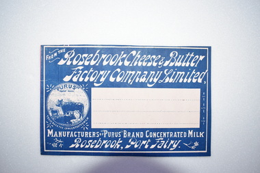
The Rosebrook Cheese and Butter Factory was opened in November 1888 by Messrs Lydiard &T F Rutledge & was a cooperative factory managed by Mr. Goldie. It operated out of the former Rosebrook Flour Mill which was built on the banks of the Moyne River near the Rosebrook bridge in the late 1840s. In 1896 the factory commenced the production of the condensation of milk. The company closed in 1911. The building and machinery were sold in 1917. Rosebrook is situated about 20 kilometres from Warrnambool on the Princes Highway. This label is of some local significance as the Rosebrook Cheese and Butter factory operated for 30 years Rectangular dark blue and white label featuring text and a trade mark. The latter is circular with three cows pictured. There are decorations of flowers and leaves. The central area of the label is white with three lines. The label is adhered to a piece of pink card.FROM THE Rosebrook Cheese & Butter Factory Company Limited, MANUFACTURERS OF "PURUS BRAND CONCENTRATED MILK Rosebrook, Port Fairy. "PURUS" TRADE MARK FOR CONCENTRATED MILKrosebrook, cheese and butter, concentrated milk, lydiard, rosebrook butter factory -
 Warrnambool and District Historical Society Inc.
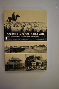
Book, StarPrinting Service Pty ltd, Soldiering On – Caramut and the Soldier Settler Movement, 2018
This book records the history of the post World War Two soldier settlement farms in the Caramut area. Number two in a series of books on Soldier Settlements in Western Victoria.This is a soft cover book of 315 pages. It has a buff-coloured cover with black and white photographs and white printing on the front cover and black printing on the spine. The book includes printed material, black and white photographs, maps and plans. non-fiction This book records the history of the post World War Two soldier settlement farms in the Caramut area. Number two in a series of books on Soldier Settlements in Western Victoria.james affleck, peterborough, soldier settlement, caramut, history of warrnambool, soldier settlement, caramut -
 Warrnambool and District Historical Society Inc.
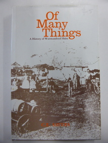
Book, Of Many Things, 1987
This book is the official history of the Shire of Warrnambool from 1863 to 1987. It was written by C.E. Sayers for the Shire of Warrnambool. Sayers also wrote the history of Warrnambool called By These We Flourish for the Warrnambool City Council. The Shire of Warrnambool was established in 1863 and the first meeting was held in January 1864. In 1992 the Shire covered an area of 1605 square kilometres and had a population of 8,940 and included the areas around Koroit, Allansford, Peterborough, Port Fairy and Nirranda. The Shire of Warrnambool was abolished in 1994 and was incorporated with other municipalities into the Shire of Moyne. This book is the official history of the Shire of Warrnambool and this copy is kept for future reference when the book is superseded or out of print. This is a hard cover book of 196 pages. It has a brown cover with gold lettering on the spine. The dust cover has a white background with an image on the front cover in brown and grey tonings of a rural property in the Shire of Warrnambool. The lettering on the dust cover is orange on the front cover and black on the spine. The book has a foreword, an introduction, 14 chapters of text, appendices and an index. There are many black and white photographs.shire of warrnambool, history of warrnambool, of many things -
 Kew Historical Society Inc
Photograph - River Moyne at Port Fairy, c.1926
Henry Beater Christian (1886-1962) , was a descendant of one of the earliest settler families in Kew. Employed at the Kew Asylum as a 'public servant', he was a skilled amateur photographer, photographing numerous scenes in Kew and on his travels around Victoria. The majority of his photographs date from 1916 to 1929. His finest photographs are housed in two photograph albums. Digital copy of a photograph from page 23 of the 47-page photograph album containing 261 gelatinous silver images, loaned by Diane Washfold with permission given to digitise and hold a copy in our collection. In the 1920s, the photographer travelled throughout Victoria, including on the west coast from Port Campbell to Port Fairy. Trips were presumably made by train and by foot. Lynda Tieman and her team at the Port Fairy Historical Society have tentatively identified a number of Henry Christian's photographs of Port Fairy, of which this is one. The scene is believed to be the River Moyne.henry beater christian (1886-1962), landscape photography, christian-washfold collection, photograph albums, river moyne, port fairy -
 Ballarat Heritage Services
Photograph - Photograph - Colour, Clare Gervasoni, Koroit Post Office, 2015, 21/12/2015
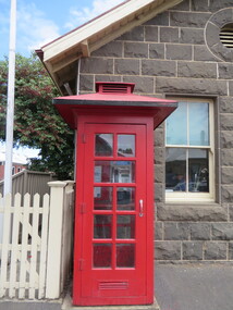
The town borrows its name from the Koroitch Gundidj people who occupied the area prior to European settlement. (https://en.wikipedia.org/wiki/Koroit, accessed 21 December 2016) Koroit was first surveyed as a township in 1847. Around the 1850 the district had the highest population of Irish immigrants in rural Australia. The Koroit Post Office was designed by architect and engineer John Mason of Port Fairy. (Moyne Shire Heritage Study 2006 Stage 2, Volume 2: Environmental History, Prepared for Moyne Shire Council Helen Doyle in association with Context Pty Ltd, 2006.) Rosebrook Bridge, Rosebrook (1853; replaced) Post Office buildings, Bank Street, Port Fairy (c.1857) The author Henry Handel Richardson lived in the Koroit Post Office as a child after her family moved to Koroit in 1878. Remembering Koroit from her youth, the third volume in her The Fortunes of Richard Mahony trilogy is set in the town. When the author was six, her father Walter died in Koroit on 1 August 1879 and was buried at the Koroit cemetery. (https://en.wikipedia.org/wiki/Koroit, accessed 21 December 2016) In 1878 Mary Richardson was appointed postmistress of the Koroit Post Office at a salary of 72 pounds with free quarters, firewood and kerosene. She lived at the back of the Post Office. (From a Green and Pleasant Land by H. McCorkell and P. Yule.) Photographs showing the bluestone Koroit Post Office, phone box and postbox. It is located at 99 Commercial Road, Koroit. "Historic Area Statement of Significance: The significance of Koroit derives from its role as the urban centre of one of the most concentrated Irish Roman Catholic rural districts in Australia, noted for its mixed livestock and cropping argicultural patterns. This is reflected in two separate and distinctive areas in the town - the administrative/commercial area and the church precinct. The administrative and commercial area (focussing on the Boundary-Commercial Road/High Street intersection and the Koroit Hotel) consists of a number of significant public buildings and leads to a street of relatively intact humble shopfronts and kerbline verandahs, visually punctuated by opposing bank facades. The church precinct is dominated by a group of Catholic buildings larger in scale and more complete in range than those in any comparably sized Victorian town." http://vhd.heritagecouncil.vic.gov.au/places/69338#sthash.ELLuSMvg.dpuf, accessed 21 December 2016."koroit, post office, phone box, payphone, bluestone, henry handel richardson, koroit post office -
 Bendigo Historical Society Inc.
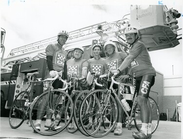
Photograph - BENDIGO ADVERTISER COLLECTION: BIKES, 1996
8091.264a Photograph: Five men in CFA Tops with racing bikes, Fire truck behing. On Rear of Photo: 15/3 PH/WG Murray to Moyne charity ride L to R John Flood, Barry Cole, Bob Ellis, Dirk Vetch, Rod Roberts. Stick on label on rear: Editorial PMT Order Pub Date 5/4 Size Width 36:6 Depth 14.5 Section National, Page 2, Description Bike Riders. Special instructions/percentage S/S Order W Date 4/4 8091.264b Newspaper Article Bendigo Advertiser 5/4/1994recreations, sports, cycling, bendigo advertiser -
 Victorian Aboriginal Corporation for Languages
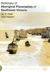
Book, Ian D Clark et al, Dictionary of Aboriginal placenames of Southwest Victoria, 2002
Dictionary including Indigenous and European place names. Origins are given.maps, b&w photographsdhauwurd wurrung, giraiwurrung, djargurd wurrung, gadubanud, buandig, gulidjan, moyne, corangamite, colac-otway, wimmera, glenelg, warrnambool