Showing 209 items
matching north beach
-
 Port Melbourne Historical & Preservation Society
Photograph - Photocopy, Shipping at north shore of Port of Melbourne (Liardet's Beach), 1700 - 2000
From red binder of family history of Caroline and Willbraham Liardet consisting of photocopies of various photos and documents, family trees, etc.donated by Philippa Gamlin, granddaughter of Leonora. .22 - Photocopy of picture showing shipping at North shore of Port of Melbourne (Liardet's Beach). Also copy of newspaper articles dated 02.02.2008 and 08.03.1997 from "The Age" Liardet pioneer family.Each leaf is numberedliardet family, phillippa gamlin, ynys grecian -
Port Melbourne Historical & Preservation Society
Document - 2014 Calendar, Pat Grainger, Historic Port Melbourne - Hotels, Sep 2013
Researched, written and designed by member Pat GRAINGER as a fundraiser for PMH&PS. 2014 PMHPS calendar ; Hotels. Cover shows Bay St from the North west showing Scott's Hotel and the National Bank of Australasia All following years calendars also recorded against cat no 1864built environment - commercial, business and traders - hotels, piers and wharves, sport - australian rules football, natural environment - beaches and foreshore, port melbourne historical & preservation society, pmhps, scott's hotel, lamb's hotel, chusan hotel, royal mail hotel, exchange hotel, united states hotel, t thomas, chequers inn, bay and boundary hotel, freemasons hotel, donaldson, peter gallienne grut, whithorn and son, foresters arms hotel, flower hotel, boundary rovers football club, wilbraham frederick evelyn liardet, pier hotel, london family hotel, prince alfred hotel -
 Port Melbourne Historical & Preservation Society
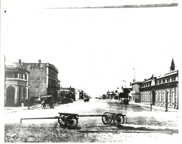
Photograph - Morley's Coal Depot cart, Bay Street, Sandridge, c. 1873
Copy of photo looking north in Bay Street from Beach and Bay, Morley's Coal Depot cart in foreground, c1873On back: view up Bay St circa 1872-3business and traders, william morley -
 St Kilda Historical Society
Photograph - Photo map, 08/02/1966
One of a series of photo-maps produced for the Department of Crown Lands and Survey (1857-1983). For correlation with a current map, and access to other historical photo maps of Victoria, see the Historic Photo-Maps Index published by the Department of Environment, Land, Water and Planning at https://services.land.vic.gov.au/DELWPmaps/historical-photomaps/Black and white aerial photographVic 1916 Melbourne 1966 Project Run 13 E 8.2.66 Lens 122 151.75MM 9.800 111st kilda, balaclava, caulfield, caulfield north, st kilda east, elsternwick, elsterwick park, elwood park, elwood canal, elwood beach, ripponlea, 1966 -
Tatura Irrigation & Wartime Camps Museum
Folder, Quobba Station
Folder put together for Tatura Historical Society and Museum.Folder describing the beaching of survivors of the Kormoran at Quobba Station near Carnarvon WA and relevant history. Photos included.17 miles well and shore. Quobba Station north north west of Carnarvon WA -
Tatura Irrigation & Wartime Camps Museum
Photograph, 1910
Taken by photographer for State Rivers and Water Supply Commission.Small black and white photograph. Waranga Reservoir embankment (north end) man left of picture, looking towards narrow gauge railway line along which the beaching material is transparent from a nearby hill. Windmill left of centre and small boat and house right corner.goulburn weir, victorian state rivers and supply commission -
 Lake Bolac & District Historical Society
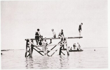
Black and white photograph, Diving Board, 2nd Beach, Lake Bolac
... beach on the north side of Lake Bolac, circa 1935.... at the second swimming beach on the north side of Lake Bolac, circa 1935 ...Red gum diving board and pontoon at the second swimming beach on the north side of Lake Bolac, circa 1935.lake bolac, swimming , diving board, pontoon, 1935. -
 Lake Bolac & District Historical Society
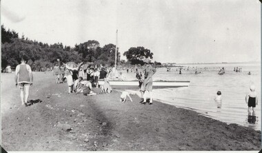
Black and white photograph, Swimming at Lake Bolac, 1946
... Lake Bolac. Swimming at the 1st beach on the north side... Highway Lake Bolac grampians Lake Bolac. Swimming at the 1st beach ...Lake Bolac. Swimming at the 1st beach on the north side of the lake in 1946.lake bolac, swimming, 1946 -
 Uniting Church Archives - Synod of Victoria
Photograph, undated c.1980s
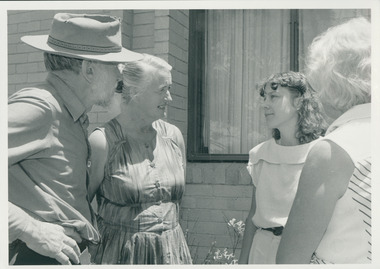
Rosalie Rayment originally trained and worked as an Occupational Therapist. Following completion of studies in Theology she worked for 11 years with the Church in Thailand. Rosalie was ordained in 1988. Fred Vanclay B.D., Dip AgS. ordained 1964 in the Presbyterian Church. Served: Queensland 1961 - 1975; Victoria 1976 - 1985 Vermont - Parkmore; Northern Territory Tennant-Barkly Patrol 1985 - 1993. Died in 2016. Adapted from the eulogy given by his son, Jerry Vanclay One of Fred’s first placements as a minister was in Mackay, North Queensland. Mackay was a wonderful place for Fred, his wife Donna and their young family. They all loved the beaches and the bush, and the children completed a significant part of their schooling there. Whilst posted in Mackay, Fred and Donna enjoyed long road trips in their modest HR Holden sedan, with the family, to Uluru, to Broome via the Borroloola Track, and down the Birdsville Track to the Flinders ranges; along the way, developing the bushcraft that would stand them in good stead later in the Tennant-Barkly Patrol. After many years in ministry in Mackay, then in Vermont, Victoria, Fred and Donna were called to the Tennant-Barkly Patrol in the Northern Territory, where he served for eight years, probably Fred’s most satisfying years. All Fred’s parishes were welcoming and rewarding, but Fred said on more than one occasion that he had a special love for the Patrol. He felt that in an urban congregation, he ministered mainly to those who came to Church, but in the Patrol he ministered to everyone, and especially to those in need. Fred loved to get involved with the day-to-day activities of his people, to develop a deeper relationship and greater understanding. Some remarked that when Fred helped, everything took longer, but they loved him and his assistance nonetheless. Fred was proud to follow in the footsteps of his predecessor Padre Fred McKay, and sometimes joked that he was “Fred the 2nd”, not Fred McKay, but “Fred from Mackay”. During his last few weeks in hospital, Fred liked to reminisce on his time in the Patrol. He joked about how he surprised the selection panel with his knowledge of bush tracks and outstations – knowledge that he had gained on those long road trips from Mackay. He reflected that many aspects of his life were good preparation for his time in the Patrol. After their Patrol, Fred and Donna retired to Mt Waverley, in Melbourne, but they were both restless in retirement, and undertook supply ministries in Wedderburn, Kerang and North Cairns, and made several long journeys into the interior and into their beloved Patrol [in Tennant Creek] – as well as frequent visits to their eight grandchildren and two great-grandchildren, and occasional trips to Europe to reunite with distant family. They never tired of ministering and adventuring, but as age and infirmity progressively clipped their wings, they travelled more in spirit and less by car. Despite the many celebrations that he blessed – baptisms, marriages, and funerals – Fred never sought the limelight, and I think he would be surprised by our gathering today. I can almost hear him saying “Don’t make a fuss; just say a heartfelt prayer together”. – Jerry Vanclay Informal B & W gloss photo of Rev. Fred Vanclay, his wife Donna, Rosalie Rayment (later ordained) and one other unidentified person. -
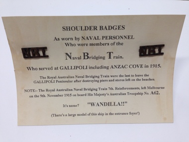 Geelong Naval and Maritime Museum
Shoulder Titles, Royal Australian Naval Bridging Train Shoulder Titles
The Royal Australian Naval Bridging Train (RANBT) was formed of 300 men based initially at Kangaroo Beach on the Gallipoli Peninsula from 1915, during WWI. They built and maintained jetties and were constantly under fire. Some of these men lost their lives and a number were wounded during their 5 months of service here. As a result the RANBT was the most highly decorated unit during WWI. The unit then continued to the Middle East, operating bridges over the Suez Canal before the unit was disbanded (Australian War Memorial online, 2014).These badges represent a highly specialised and decorated Unit from WWI. The RANBT was made up of 300 men who served in Gallipoli and in the Middle East from 1915-1917. The badges are associated with Australian defense and form significant links to ANZAC history. A pair of brass shoulder titles "NBT" from the Naval Bridging Train attached to paper card. They have a loop shank at the back for fastening."NBT" Naval Bridging Trainshoulder title, royal australian naval bridging train, ranbt, navy shoulder badge -
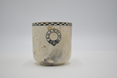 Geelong Naval and Maritime Museum
Teacup
The Orungal was originally built in Glasgow in 1923 for the Khedival Mail Steamship & Graving Dock Company of Egypt and named the S.S. Fezara. Due to the effects on steamship companies of the Great Depression including the steep costs of building new ships and increases in running costs and port charges, no new passenger ships had been ordered in Australia since before World War One. To meet demand for passenger berths, the Fezara (5826 tons) along with its sister ship the Famaka (5856 tons, renamed Ormiston), were chartered by the Australasian United Steam Navigation Company Ltd (A.U.S.N.Co.) in 1927. Both the A.U.S.N.Co and the Khedival Mail Steamship Co. were part of the P&O Group. The Orungal operated in this role as an interstate passenger and mail steamer between 1927 and 1940, being used mainly on the Melbourne to Queensland and Western Australian runs, with 240 single class berths. Following the outbreak of World War Two six of the nine large passenger liners servicing mainland Australian passenger and mail trades were requisitioned by the Government to ferry equipment, troops and supplies. Some of them were converted to armed merchant cruisers and used for patrol work and escort duties in the Indian and Pacific Oceans. The Orungal had originally been requisitioned by the government along with the Zealandia on 25 June 1940, to transport troops to Darwin, but was returned to commercial service because "of her unsuitability", perhaps too slow for the demands of the work. Despite being rejected for patrol and convoy duties the Orungal still had a vital role as one of only three passenger liners left to service the mainland Australian trade. Following its requisitioning by the Government shortly after war broke out, it had been fitted out with defensive armament. On its final voyage arriving at Port Phillip Heads from Sydney, Captain Gilling was attempting to enter the Heads ahead of a worsening south-westerly storm and, with a minefield known to have been laid in the area, had been warned by the Navy not to deviate from the swept channel. The captain and crew held fears that in the stormy seas a mine may have been carried away. In the worsening weather a blur of lights at Barwon Heads was mistaken for Port Lonsdale, and the Orungal steamed ashore onto Formby Reef, just east of the entrance of the Barwon River - instead of passing safely through the middle of the Rip. At the Marine Board Inquiry Capt. Gilling - who had been master of the Orungal since 1926 - stated that after becoming uneasy about his position and changing course to starboard one point: " At 10.21 pm I ordered the engine room to stand by and gave instructions for the patent log to be hauled in and for the sounding-gear to be got ready. Approximately two minutes later, in a flash of lightning, I saw land off the port beam. I immediately recognised it as Barwon Heads, and ordered the helm to be put hard to starboard, but the vessel struck before she had time to answer the helm" Barwon Heads and Ocean Grove residents were startled to hear the shrill blast of the ship's whistle, followed by the bright flares and explosions of signal rockets. The Queenscliff lifeboat crew, who had responded to the tragic collision between the Goorangai and another passenger liner the Duntroon in Port Phillip Bay less than 24 hours earlier, were later praised for their efforts in safely taking off all the passengers and crew. Most of the passengers were asleep at the time of the wreck, and were woken up by the commotion, the ship shaking "from stem to stern" and stewards ordering them to lifeboat stations in driving rain. It was a dramatic time with the ship siren wailing and distress rockets being fired. It was reported that "When it was found the ship was safe, the passengers all went to the music room. There they sang and danced for several hours. The ship's orchestra played merrily, and amateur performers among the passengers clowned, danced and sang to keep the laughter going. In the early hours of the morning passengers went to their cabins, most of them to sleep soundly while the keel grated on the rocks". At dawn the Queenscliff lifeboat arrived at the scene having been launched at 2.30am, and cautiously approached the ship which was being "battered by mountainous seas". By 5am oil from a burst oil line was helping to calm seas around the Orungal sufficiently enough for the lifeboat to approach, and all the passengers and crew were taken off in several trips by the lifeboat. A Court of Inquiry later found that the wreck was caused by an abnormal set of current to the north-west and cleared the officers and crew of neglect of duty. The sight of a huge liner almost on the beach saw an unprecedented amount of traffic as people drove an estimated 10,000 cars, using some 60,000 gallons of fuel in a time of strict petrol rationing, to see the spectacle. Salvage operations began in an attempt to refloat the vessel, scheduled for the high tide on 15 December 1940. However, during these operations, at 2.30 am on 13 December 1940, a major fire broke out, believed to have been caused by spontaneous combustion in the boiler room. The ship was soon ablaze, with smoke pouring from its hatches and ventilators, and at mid-morning the magazine exploded fiercely. Of the 60 men working aboard the vessel two were severely burned and had to be taken to Geelong Hospital. The gathered spectators witnessed the eerie sight of the ship's hull glowing red when night fell. The well-known building demolition contractor Whelan the Wrecker bought the salvage rights, and methodically proceeded to dismantle the ship and its fittings. The drama was not yet over for the wreckers when - without warning - the burnt-out hulk was 'attacked' by RAAF for strafing practice. Salvage rights were transferred to another private owner in 1963. By 1945 the combined effects of the exposed location, fire and salvage had seen what was left of the wreck disappear beneath the waves. The site today is marked by two of the four Scotch type boilers sitting upright and exposed at low tide, just north-east of the small boats channel at the entrance to Barwon Heads. Large sections of steel hull plating and framing, and impressively large pieces of ships structure and machinery including masts, booms, deck winches, propeller shaft, flywheel, and a thrust block lie scattered about and make the site an interesting shallow dive. It is interesting to compare the site of the Orungal with the intact remains of similar large passenger ships scuttled in deep water in the Ships' Graveyard, such as the Milora and Malaita. The site is subject to waves and surge, and is best dived on flat calm days The teacup originated from the SS Orungal and was likely used heavily in the ship's life as a passenger, mail and cargo carrier around Australia. The teacup is significant for its connections to SS Orungal and of this ships connected story of being sunk in extraordinary circumstances in the local region. A.U.S.N. Co. Ltd. Teacup salvaged from SS Orungal ss orungal, fezara, world war two, barwon heads, ocean grove -
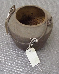 National Wool Museum
Pot, smelting
... south from Western Beach Road between Dalgety North building... running south from Western Beach Road between Dalgety North ...Found by Roger Cummings and J Lewis in laneway running south from Western Beach Road between Dalgety North building and Dennys Lachelles building (old Corio Tannery site). -
National Wool Museum
Pot, smelting
... south from Western Beach Road between Dalgety North building... running south from Western Beach Road between Dalgety North ...Found by Roger Cummings and J Lewis in laneway running south from Western Beach Road between Dalgety North building and Dennys Lachelles building (old Corio Tannery site). -
 Ballarat Tramway Museum
Negative, Wal Jack, early 1950's
Negative and Digital images of the Wal Jack Ballarat Negative file of Geelong 32 in Aberdeen St, just after turning from Pakington St. The tram has the destination of North. In the background is a shop advertising Spartan paints. Photo early 1950's.trams, tramways, geelong, pakington st, aberdeen st, beach, tram 32 -
 Ballarat Tramway Museum
Photograph - Digital image Set of 2, Doug Colquhoun, c1955
Set of two colour digital images of Geelong trams photographed by Doug Colquhoun? .1 - Geelong No 8 at the Chilwell terminus, c1955. Note the tram stop furniture on the pole behind. Tram has the destination of Beach. .2 - Trams 31 and 34 photographed in Moorabool St at a Safety Zone stop. Safety Zone stop sign in photograph. Trams have the destination of Belmont and North. Kays pastries and Austral Art Furnishers stores building in the background.trams, tramways, geelong, north, belmont, moorabool st, safety zone, tram 8, tram 31, tram 34 -
 Bayside Gallery - Bayside City Council Art & Heritage Collection
Map, Department of Crown Lands and Survey et al, Moorabbin, County of Bourke, Government Roads, 1920
The cadastral map of the Parish of Moorabbin in Victoria (L.6104) shows parish boundaries and land ownership 1920 when Sandringham was a Town. The government roads have been coloured in red pencil.moorabbin, county of bourke, map, plan, land subdivision, land titles, foreshores, hampton, beaumaris, highett, cheltenham, department of lands and survey, land owners, cartographic material, brighton, sandringham, town of sandringham, government roads -
 Bayside Gallery - Bayside City Council Art & Heritage Collection
Map, Department of Crown Lands and Survey, Moorabbin, County of Bourke, c. 1918
The cadastral map of the Parish of Moorabbin in Victoria (L.6104) shows parish boundaries and land ownership c. 1918 when Sandringham was a Borough.moorabbin, county of bourke, map, plan, land subdivision, land titles, foreshores, sndringham, hampton, beaumaris, highett, cheltenham, department of lands and survey, land owners, cartographic material, borough of sandringham, brighton -
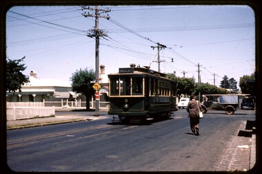
 Kew Historical Society Inc
Functional object - Destination Roll, Melbourne & Metropolitan Tramways Board, 1960s
... / Domain Rd / Hanna St Depot / South Melb & St Kilda Beach... St Depot / South Melb & St Kilda Beach / Prahran / North ...In an era predating the computerisation of equipment on public transport, where trams in Melbourne were driven by drivers and conductors sold fares, destinations were shown at the front and rear of the tram within a glazed box. A driver adjusted the roll to select each new trip destination. Given the length of rolls, in this case approximately nine metres, this could be a time consuming process. In addition to the named destination roll, each tram included a separate roll listing the route numbers.The roll was purchased at a Leski Auction in Armadale as part of a large group of tramways memorabilia including tram 'rolls' from New South Wales, Victoria, South Australia and Tasmania. The auction house described the collection as "The collection of destination blinds or rolls that forms the core of the Railways Trams & Buses Section (Lots 655 – 732) is the best we have ever offered and represents a life-time of collecting by an Adelaide enthusiast, now deceased." Melbourne & Metropolitan Tramways Board Tramways Destination Roll. Black and white paint on linen roll. Forty-eight named destinations including four depots - Camberwell, Hanna Street, Hawthorn, Kew. Multiple destinations in what is now the City of Boroondara (Kew, Hawthorn and Camberwell); including East Kew, Kew, Kew Post Office, Kew Depot, and Cotham Road.Named destinations beginning to end: “Olympic Park / Special / Football / Racecourse / Richmond / Burnley / Riversdale / Wattle Park - Warragul Rd / Wattle Park - Elgar Rd / City / Burwood / Hartwell / Bowen St / Camberwell Depot / Camberwell Jucn / Leura Grove / Gardener / Glenferrie Rd / Chapel St / St Kilda Rd / Camberwell / City / Lonsdale St / University / City via William St / Domain Rd / Hanna St Depot / South Melb & St Kilda Beach / Prahran / North Richmond / Windsor / Hawthorn Depot / Hawthorn / Spencer St / Toorak Rd / Swan & Church St Cnr / North Balwyn / City Flinders & Spencer Sts Corner / City - Market St / Swanston St / Simpson St / East Kew / Kew / Kew Post Office / Kew Depot / Cotham Rd / Malv Tn Hall"melbourne & metropolitan tramways board -
 Williamstown Botanic Gardens- Hobsons Bay City Council
Oral History - Williamstown Botanic Gardens - Cyril Curtain, 24 July 2014
The interview is one of a series recorded in 2013-2014 to document memories and experiences of the Williamstown Botanic Gardens Cyril Curtain was born in Williamstown in 1928. He attended North Williamstown Primary School and Williamstown High School. Shortly after marrying he purchased a house on the Esplanade, where he still lives and in which this interview took place. Cyril’s work in conservation of the natural and built heritage is highly regarded. The recently developed Cyril Curtain Reserve in Williamstown is named in his honour. In this interview Cyril discusses the Gardens and the foreshore area including the beach and L A Parker Reserve A primary source of information on memories of the Gardens.CD and transcript of interview with Cyril Curtain and his memories of the Gardens and surrounding environs.fish pond, curator, cannons, williamstown botanic gardens, hobsons bay city council, aviary, pinetum, centennial reserve, midsummers night dream, cable tram car seats, infrared photography, , rotunda, gloucester reserve, 1934 storm, national trust, bateman house, clarke statue -
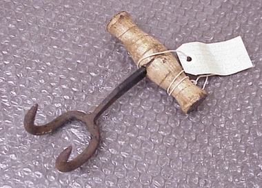 National Wool Museum
Bale Hook
... Western Beach Road between Dalgety North building and Dennys... from Western Beach Road between Dalgety North building ...Found by RC and J Lewis in laneway running south from Western Beach Road between Dalgety North building and Dennys Lachelles building (old Corio Tannery site). -
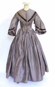 Brighton Historical Society
Clothing - Dress, Day dress, Circa 1850
A dress believed to have belonged to a family member of Mrs. Jessie Somerville Singer (nee Watson), 1849-1935. As the dress dates from circa 1850, it could have belonged to someone from one generation previous, possibly her mother Elizabeth Watson. Jessie Somerville Singer was the second wife of Mr. Edward Singer (1829 – 1904) of 'Somerville', New Street, Brighton Beach. Edward's first wife, Maria, died in 1861; their son William died approximately 12 months later. In the 1861 census of North Bradley England, Edward was recorded as a carpenter journeyman. After these tragedies Edward, then aged 30, left England to start a new life in Australia. He emigrated as an unassisted passenger on the steamship 'Great Britain', departing from Liverpool and arriving in Melbourne in April 1863. Edward worked as a joiner and overseer for a timber merchant in Franklin Street, Melbourne. In December 1869 he bought a property at 1115 Hoddle Street, East Melbourne, between Hotham and George Streets. At some stage he also acquired 1117 Hoddle Street. He also owned another property in Rushall Crescent, North Fitzroy. On 10 July 1873 Edward married Jessie Somerville Watson, the daughter of William Watson and Elizabeth Martin. They lived at Hoddle Street for some years, later moving to Rushall Crescent, North Fitzroy before in the 1880s settling in what was then the semi-rural suburb of Brighton. Edward is recorded as working there as a joiner. The house 'Somerville' was built by the Singers in circa 1880 at 100 (now 78) New Street, Brighton. The family moved there upon Edward's early retirement and lived there until 1941. 'Somerville' was sold, the house demolished and the land subdivided in the 1930s. Edward and Jessie appear to have lived comfortably. Edward died on 30 July 1909. Jessie died on 11 November 1935. Many members of the Singer family have lived in and around Brighton since Edward and Jessie first made their home there. The donor, Mrs Dorothy Constance Cook, was Jessie's granddaughter.A silver and brown striped silk taffeta dress comprising separate bodice (.1) and skirt (.2). The dress features a high round neckline fastening down the centre front with concealed hook and eye closures with ten (two missing) decorative brown silk velvet buttons. The front and back feature a briown silk velvet ribbon that forms a v shape from the shoulder to the centre front just below the bust and centre back below the shoulder blades. From the ribbon falls a brown and silver silk fringe approx seven cms deep. The bodice is shaped and boned into the waist and finishes in a deep v over the stomach. At the back the bodice is shaped to the body finishing in a smaller curved v over the small of the back. The sleeve attaches to the bodice at the true shoulder and falls in a pagoda sleeve to the mid forearm. The sleeve is also trimmed with brown silk velvet ribbon near the base of the sleeve. The full skirt is pleated at the waist, falling to the floor, longer at the back to accommodate the crinoline.somerville, new street brighton, jessie somerville singer, edward singer, elizabeth martin, brighton, 1850s -
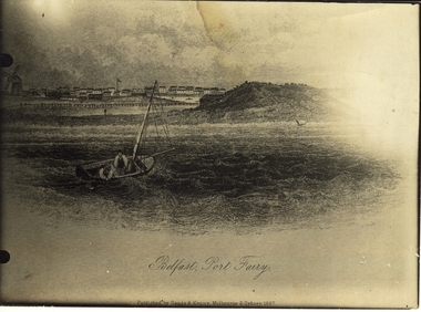 Port Fairy Historical Society Museum and Archives
Work on paper - Lithograph, S.T.Gill, Belfast, Port Fairy, 1857
Seascape from original drawing ascribed to S.T. Gill - "Belfast, Port Fairy" published 1857Photograph of etching of seascape drawing of Port Fairy (artistic view) town looking north west from the sea showing town and windmill on the left, a man in a dingy, island in the middle and a sailing ship and Battery Hill on the rightBelfast, Port Fairy - Published by Sands and Kenny Melbourne and Sydney 1857beach, ocean, dingy, windmill, town, sea, ship -
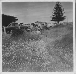 Port Fairy Historical Society Museum and Archives
Photograph, East Beach parking 1950-1960s
East Beach parking 1950-1960s looking North and upwards from the beach trackBlack and white landscape showing cars parked overlooking the East Beach with a Norfolk Island pine in the backgroundbeach, sea, seascape, east beach, norfolk island pine -
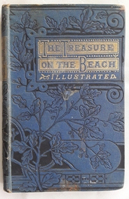 Mont De Lancey
Book, M.A.P, The Treasure on the Beach and What it did for Gilbert West, c late 1800's
A young boy finds what he thinks is treasure when he walks along the beach near his home. The story has religious themes and depicts family life in England in the late 1800'sSmall blue hardcover children's book - The Treasure on the Beach and what it did for Gilbert West by M.A.P. The front cover has a black floral design which continues onto the spine and the back, with the title surrounded in gold boxes and the word, Illustrated, in gold lettering underneath. On the back is a symbol for the publisher Sunday School Union. Black and white illustrations throughout with one on the frontispiece of Gilbert West on the beach. Black and white illumination style lettering is used for the first word of each new chapter. Tissue paper covers the title page. 107p.fictionA young boy finds what he thinks is treasure when he walks along the beach near his home. The story has religious themes and depicts family life in England in the late 1800'schildren's fiction, family life fiction, adventure stories -
 Mont De Lancey
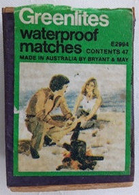
Container - Matchbox
A Bryant & May Greenlites matchbox containing wooden waterproof matches. The front of the box has the name Greenlites waterproof matches printed in white and black lettering on a green background with an illustration of a man and a woman boiling a billy on an open fire at the beach. There are worn striking surfaces on each side. The box is covered in purple paper.Greenlites waterproof matches E2994 Contents 47 Made in Australia by Bryant & Maymatches, matchboxes, safety matches, cases -
 Mont De Lancey
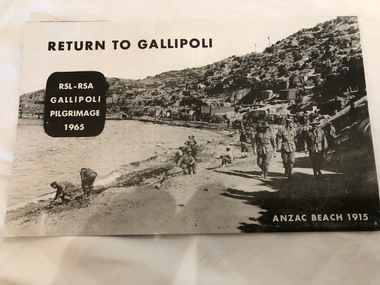
Pamphlet, 1965
Black and White printed pamphlet with yellow coloured pictures inside."Return to Gallipoli RSL-RSA Gallipoli Pilgrimage 1965 Anzac Beach 1915"pamphlets -
 Mont De Lancey
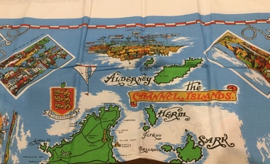
Functional object - Tablecloth
A square, souvenir tablecloth from the Channel Islands. On an azure background, all the islands are printed and named on the tablecloth, as well as the names of the towns, villages and the bays of both Jersey and Guernsey. There are four rectangular pictures, surrounded by a white border, representing significant places and buildings, as well as others, without borders, depicting old and modern ships, a compass, a coat of arms and the distinctive Jersey and Guernsey cow.There is a red and white border, almost at the edge of the azure background and in each corner is printed a white anchor and rope. There is also a 3 cm. plain white outer border around the tablecloth.Names of places, beaches and bays on the Channel islands. Pictorial representations of significant places and buildings and a white anchor and rope in each of the four corners. "Exclusive to Creaseys of Guernsey" is printed at the bottom left hand corner of the tablecloth.table ware., household textiles., table linen. -
 Phillip Island Conservation Society Inc.
Work on paper - Photocopy of newspaper cutting, "PENGU/ CHOK/ IN/ OIL" (meant to be : "Penguins choke in oil"
With the establishment of the large heavy industrial zone at Hastings in the late 1960s, which included the BP oil refinery using the Port of Hastings at the north-western arm of Western Port, a number of environmental problems predicted by both scientists and conservationists arose. The main shipping channel on the western arm of Western Port was dredged, causing suspended particles affecting seagrass beds. With inadequate regulation around discharge of bilge water within the bay, and oil spillage, oil pollution affecting both seabirds and coastal areas was not uncommon. This report of 40 penguins actually known to have been killed by an oil spill event was typical of reports at the time. The 2 men quoted – Vernon Johnson and Ken Pound – were well known conservationists. Vernon and his wife Nora owned the Kingston Gardens picnic and zoo business where they cared for many injured wildlife. Ken was a Phillip Island counsellor for a few years, and instrumental in the establishment of the Phillip Island conservation Society. He also contributed various documents and newspaper cuttings to this archive.This article is significant for being a record of an exact number of penguins found dead from oil spill pollution in Western Port. Also as a record of conservationists in the early years of community and environment movements both locally and in Australia. The article further gives evidence of linking tourism with wildlife.Photocopy of newspaper cutting. Black print with very dark black and white photo of Fairy (Little) Penguin. Poor reproduction due to older photocopy machine.(indecipherable) - late/1960s.little penguins, fairy penguins, eudyptula minor, penguin behaviour, phillip island tourist attractions, phillip island conservation society, oil spills, bp refinery hastings, port of hastings, western port, marine pollution, oil tankers, vernon johnson, ken pound, phillip island promotion association -
 Phillip Island Conservation Society Inc.
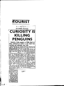
Work on paper - Newspaper cutting, Unknown journalist, the Express newspaper, Wonthaggi, "Tourist Curiosity is killing penguins", 30.01.1964
Due to increased numbers of tourists in the post-World War Two era, and the increased popularity of the Penguin Parade, without sufficient public education or protection of the penguin habitat, many Little Penguins perished during the 1960s. Trampling, unsupervised interference with the birds, unrestricted access to their dune habitat, plus predation by foxes, cats and dogs, led to most of the rookeries outside of the Summerland patrolled areas - such as on the west and north Phillip Island coasts, and parts of the south coast - being obliterated by the mid 1970s.this article is highly significant as it was published shortly before the establishment of the Phillip Island Conservation Society Inc in 1968, which commenced agitation to make management of Crown Land by Phillip Island Shire Council and government bodies accountable for protection of wildlife habitat on Phillip Island.photocopy of newspaper cutting. Black print on white paper. 3--1-64phillip island, penguin parade, little penguin, habitat destruction, penguin parade committee, shell house, -
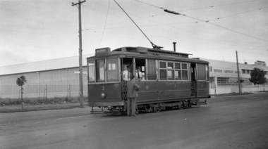
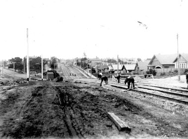 Ballarat Tramway Museum
Photograph - Geelong Tramway North line
Men laying sleeper tram tracks for the North tram route along The Esplanade. In the midddle distance, the double track towards the city is in Mercer St. (now The Esplanade South). The street off to the left is Victoria Tce., (now Western Beach Road). 1928Black and white print on paper.GRS710/25/1/10 and 25-10, written on the reverse in paper. The No., 2 inside a circle, written on the reverse in ink.geelong tramway, geelong tramway laying sleeper tracks