Showing 632 items
matching river st
-
 Warrnambool and District Historical Society Inc.
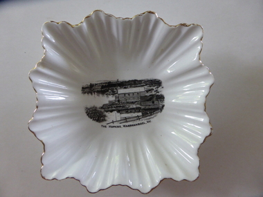
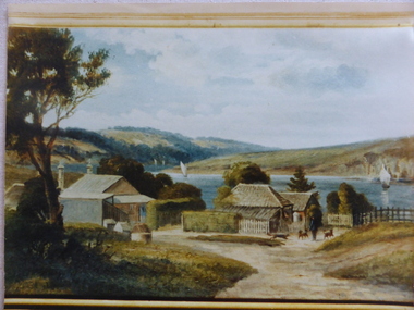
Plate, The Hopkins Warrnambool
This is a dish sold to tourists visiting Warrnambool in the 1920s as a souvenir of Warrnambool and the Hopkins River. It was made by the Royal Stafford Bone China Company which was founded in the mid 1800s and based in Stoke-on-Trent in Staffordshire, England. The scene depicting the Hopkins River mouth shows the Lyndoch windmill, the Lyndoch bungalow built in the early 1920s by Florence Lake, Proudfoots Boathouse and the Rowing Club building. This dish is an interesting example of the high-quality souvenirs sold to tourists in the mid 1920s. Local Warrnambool residents may also have purchased an item such as this. Souvenir items depicting local scenes are still sold today in most places in Australia.This is a square-shaped white china dish with a fluted edge and gold colouring on the edge of the fluting. In the centre of the dish is a black and white image of the mouth of the Hopkins River near its mouth. On the base is a blue stamp of the maker of the dish. ‘The Hopkins, Warrnambool, Vic.’ ‘Guaranteed Royal Stafford English Bone China, Made in England’ hopkins river, warrnambool, lyndoch, warrnambool, history of warrnambool -
 Warrnambool and District Historical Society Inc.
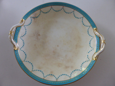
Plate, Rolfe dinner plates x 4, 1864
These dishes were part of a crockery set used in the George Rolfe household at Lyndoch, Warrnambool. George Rolfe (1836-1919) was a Melbourne tea merchant who acquired land at the mouth of the Hopkins River in Warrnambool from the 1880s on as a holiday home. He developed the property over the years, adding a windmill and reservoir, bone and chaff sheds, a stable, jetty and boathouse and an extensive garden. In 1891 he married Mrs Annie Lake and it was his stepdaughter, Florence Lake who built the house, Lyndoch in the 1920s. This building today forms part of an Aged Care Facility. This item is part of the larger Rolfe dinner set as described on Victorian Collections at VC001421 and VC001422These dishes are of importance as they belonged to the George Rolfe family of Lyndoch, Warrnambool. They demonstrate the quality of the household goods used by more affluent families in the second half of the 19th century. These are four china serving dishes or plates which are part of a set of crockery used in the Rolfe Lyndoch household in Warrnambool. The dishes have a circular base with a circular dish resting on the base. The dishes have or had two handles with these handles and the edges of the dishes being gold trimmed. Around the rim of the dishes is a pattern of loops and dots etc of teal and gold. One dish (.1) has no handles, one dish (.4) has one handle only and two dishes are cracked (.3 & .4) . Two dishes are stained, one severely (.2 & .4) ‘Minton’ george rolfe, florence lake -
 Warrnambool and District Historical Society Inc.
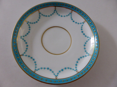
Plates, Rolfe Saucers x 6, 1864
These saucers are part of a crockery set that belonged to George Rolfe and his family. George Rolfe (1836-1919) was a tea merchant in Melbourne who bought land at the mouth of the Hopkins River in Warrnambool in the 1880s. He had adjoining land and the properties of ‘Shipley’ and ‘Fairy Hill’ and developed ‘Lyndoch’, adding stables, jetty, boat house, windmill and reservoir, chaff and bone sheds and an extensive garden. In 1891 he married Annie Lake and it was his stepdaughter, Florence Lake who built the ‘Lyndoch’ house still standing today. ‘Lyndoch’ today is now the site of an Aged Care Facility. This item is part of the Rolfe Dinnerset as described on Victorian Collections at VC001420 and VC001422.These saucers, part of a crockery set, are kept because they belonged to George Rolfe, a prominent property owner and farmer in Warrnambool in the late 19th century and early 20th century. The items, dating from 1864, have social significance showing the type of crockery used by a more affluent family in the 19th century. These are six circular china saucers with a gold rim and ornamentation in a scallop design in gold and teal around the rim and the outer edges. The base of the saucers has a gold rim. One of the saucers has a chip on the edge and four show significant wearing of the inner gold circle. Some of the outside gold edging also shows wear. The maker’s marks and name are indented on the bottom of the saucers ‘Minton’ lyndoch, warrnambool, rolfe and co., george rolfe, history of warrnambool, florence lake -
 Warrnambool and District Historical Society Inc.
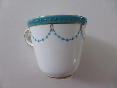
China, Cups x 4, 1864
These dishes were part of a crockery set used in the George Rolfe household at Lyndoch, Warrnambool. George Rolfe (1836-1919) was a Melbourne tea merchant who acquired land at the mouth of the Hopkins River in Warrnambool from the 1880s on as a holiday home. He developed the property over the years, adding a windmill and reservoir, bone and chaff sheds, a stable, jetty and boathouse and an extensive garden. In 1891 he married Mrs Annie Lake and it was his stepdaughter, Florence Lake who built the house, Lyndoch in the 1920s. This building today forms part of an Aged Care Facility. This item is part of the larger Rolfe dinner set as described on Victorian Collections at VC001421 and VC001422These cups are part of a crockery set, and are kept because they belonged to George Rolfe, a prominent property owner and farmer in Warrnambool in the late 19th century and early 20th century. The items, dating from 1864, have social significance showing the type of crockery used by a more affluent family in the 19th century.Four small white cups decorated with aqua band around the top of each cup . A scalloped pattern of dots are suspended from the solid band which is decorated with a row of gold dots. There is a gold rim at the base of the cup.Mintonrolfe, lyndoch, warrnambool, minton cups, mrs annie lake -
 Warrnambool and District Historical Society Inc.
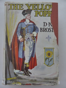
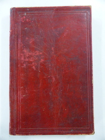
Book, The Yellow Poppy by D K Broster, 1937
This book comes from the property of Lyndoch near the mouth of the Hopkins River. George Rolfe, a tea merchant from Melbourne, established Lyndoch in 1875 and Miss Florence Lake, daughter of Miss Annie Lake, later Mrs George Rolfe, inherited the property with her sister Annie. In 1920 Florence Lake built a large house called Lyndoch. She had a Rolls Royce car and a chauffeur and was a tireless worker for local charities. Florence Lake died in 1946 and the property became the site of an Aged Care Facility in Warrnambool. Florence Lake’s house now forms part of the hostel section of this facility. This book would have been in the Lyndoch library during Florence Lake’s time there. D K Broster ( Dorothy Kathleen) was a popular writer of historical novels in the early part of the 20th century. The Flight of the heron being her most acclaimed This book is of interest as it came from the historically-important property and house known as Lyndoch and so it is connected to Miss Florence Lake, a prominent person in Warrnambool in the first half of the 20th century. This is a hard cover book of 439 pages. It has a red cover with black lettering on the front and spine. It also has a dust cover which has a colour image of a man in late 18th century attire and a shield containing a yellow poppy. The dust cover is partly torn away. The book has 46 chapters. The inscription is handwritten in black ink. ‘Lyndoch Xmas 1937’lyndoch, florence lake, history of warrnambool -
 Warrnambool and District Historical Society Inc.
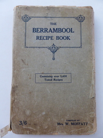
Book, The Berrambool recipe book, 1915
This recipe book has been compiled by Mrs W. Moffatt to raise funds for the Wickliffe Hall Improvement Fund (1915). Wickliffe is a small town in Western Victoria situated on the banks of the Hopkins River on the Glenelg Highway 100 kilometres from Warrnambool. Jessie Moffatt (nee McLellan) married William Moffatt in 1885 and died in 1938. William Moffatt leased the Berrambool Estate near Wickliffe in 1893, bought it in 1903 and the Moffatts lived there until their deaths in the 1930s. This recipe book is of interest because of its social history, telling us what recipes were popular in the early 1900s and the use made of a recipe book to raise funds for local community funds. The book is also of interest because it is an example of the voluntary work done by a woman in the Western District in the early 20th century. The book is also of interest because the names of some of those who contributed the recipes are listed and many of them have local connections. The Warrnambool names listed include Williams and McCormick. This is a soft cover book of 149 pages. The cover is grey with dark blue lettering and some ornamental patterning. The book contains over 1400 recipes and many advertisements for businesses in Victoria at the back and front of the book. There are two loose sheets of paper with recipes. The binding has come apart and has been loosely mended with adhesive tape. The cover and some of the pages are a little tattered. jessie and william moffatt of berrambool, history of warrnambool -
 Warrnambool and District Historical Society Inc.
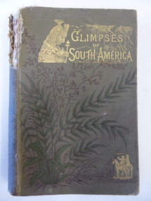
Book, Glimpses of South America, 1882
This book was given as a Sunday School prize to James Cassady. The donor was William Wines. The Wines families were pioneers in the Woodford district. James Cassady was the son of William and Elizabeth Cassady and the family lived at Boughton on the Merri River (near Cassady’s Bridge, Caramut Road today). This property was established about 1845. Charley and Joe, whose names have also been written in the book, were James’ brothers. This book is of interest because it belonged to James Cassady, the son of pioneer settlers in Cassadys’ Bridge/Woodford area. This is a hard cover book of 220 pages with 32 extra pages at the back of the book giving information on other books produced by the same publisher. The cover is grey-green with gold lettering, green and black floral decorations and gold images of two men on horseback and a South American Indian chief. The spine is torn away at the top and the cover and pages are stained and crumpled. There are many black and white illustrations throughout the text, with the frontispiece protected by a piece of tissue. The inscriptions are handwritten in black ink and pencil.‘Woodford Sunday School presented to James Cassidy (sic) by his well-wisher William Wines’ (this is re-written underneath in pencil with the correct spelling of ‘Cassady’) ‘Chaley cassady, boughton, merri river (sic) “Joe’ james cassady,, boughton, william wines, woodford sunday school, history of warrnambool -
 Warrnambool and District Historical Society Inc.
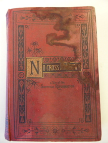
Book, No cross no crown
This book has been given by the Woodford Sunday School to Edith Cassady (note the misspelling of ‘Cassady’). Edith Cassady was the daughter of William and Elizabeth who lived at Boughton on the Merri River (near Cassady’s Bridge, Caramut Road today). This property was established about 1845. The donor of the book was William Wines, a member of a pioneering family in the Woodford district. This book is of some interest as it belonged to Edith Cassady, a member of a pioneering family who lived at Boughton on the Merri River. This is a hard cover book of 344 pages. The cover is red with black border decorations and black and gold lettering. There are several full page black and white illustrations scattered throughout the book which has 23 chapters of story. The cover and pages are much water-stained. The inscription is handwritten in black ink. ‘Woodford Sunday School Presented to Edith Cassidy (sic) by her well-wisher William Wines’ william wines, woodford, history of woodford, edith cassady, boughton property, cassady family -
 Warrnambool and District Historical Society Inc.
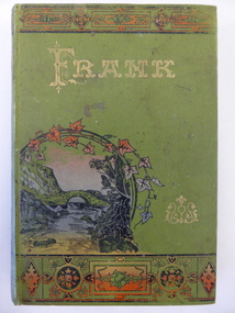
Book, Frank, Late 19th century
This book was given as a prize in 1892 to Joseph Cassady from the Cassady’s Bridge State School. This school, once located near Cassady’s Bridge on the present-day Caramut Road, was opened on 19th January 1891 and closed in December 1892. The first teacher was Janet Ada McDougall and the teacher when the school closed was J. H. Delahenty. The Cassady family had the farm, Boughton and this was established about 1845 on the Merri River near where the bridge is today. Joseph was born in 1882 to William and Elizabeth Cassady.This book is of considerable importance as it is the only memento we have of Cassady’s Bridge State School. This school only existed for two years.This is a hard cover book of 208 pages. The cover is green with coloured borders and a coloured sketch of a stream and a bridge. The lettering on the front cover and the spine is gold and the pages are gilt-edged. The cover is much faded. Some of the back pages are partly torn away. The book has two black and white sketches at the front of the book and 28 chapters of story. The inscription is handwritten in black ink and the inscription page is stained. ‘State School Cassady’s Bridge Xmas 1892 Presented to Joseph Cassady 3rd Class for Good Progress. J.H. Delahenty Head Teacher’ cassady family, boughton, history of warrnambool -
 Warrnambool and District Historical Society Inc.
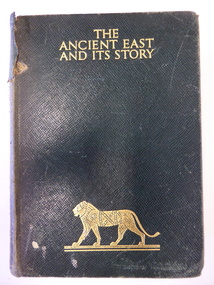
Book, The Ancient East and it's story, Mid 20th century
This book was given in 1943 by the Warrnambool Technical School to Joyce Goodall. Considering that World War Two was in progress at the time, the book was an expensive one to be given as a school prize. But the donor was Miss Florence Lake, the daughter of John and Annie Lake and the step-daughter of George Rolfe of Lyndoch, near the Hopkins River mouth. Miss Lake inherited the property and built the residence known as Lyndoch that is today part of the Lyndoch Aged Care Facility. Miss Lake was known for her philanthropy and community work in Warrnambool. John King’s name has been crossed out in the book as he was no longer Principal in 1943. He was the founding principal of Warrnambool Technical School in 1911 and remained there for 29 years. The Goodall family established Wanstead Farm in East Warrnambool in the 19th century and Joyce Goodall was descended from the Mortlake branch of that family.This book is of interest because of its association in 1943 with Joyce Goodall, Florence Lake and Warrnambool Technical School. This is a hard cover book of 472 pages. The cover is brown with gold lettering and the image of a lion on the front cover and a scroll pattern on the spine. The book has a preface, 41 chapters and an index. There are eight colour plates scattered throughout the text. The book plate on the first page is printed and pasted in and it has typed material added to it. Another inscription has been handwritten in pencil. There are also several notes and quotations handwritten in pencil on the back page. The cover is stained and torn in some places and many of the pages are stained. ‘Warrnambool Technical School, Labor to Efficiency, 8th December 1943, for Outstanding Efficiency in Art Subjects, Donated by Miss Lake, Awarded to Joyce Goodall, John King Principal’ (the name ‘John King’ has been crossed out) ‘Joyce Goodall 198 Timor Street Warrnambool’ joyce goodall, florence lake, warrnambool technical school, history of warrnambool -
 Warrnambool and District Historical Society Inc.
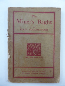
Book, The Miner’s Right, 1922
This book about the New South Wales goldfields was written by Rolf Boldrewood in 1890. It is retained because the author played a significant part in Warrnambool’s history. Rolf Boldrewood, the pen name of Thomas Browne, first came to the Warrnambool district in 1842, visiting the Bolden brothers’ property, Grasmere. He camped on the banks of the Merri River for about six months and described the area, including Warrnambool Bay, some years later in his book Old Melbourne Memories. In 1844 Thomas Browne established the property, Squattleseamere near Bessiebelle, north west of Portland. He remained there for ten years then moved to New South Wales. The last forty years of his life were spent writing and he became well-known for the classic Australian novel, Robbery Under Arms. This book is retained because it is a 19th century example of the writings of Rolf Boldrewood. He is important in Warrnambool’s early history as he was in the area in the early 1840s. His account of the area at that time is the most important one we have of the area that was later to be the site of the new settlement of Warrnambool.This is a soft cover book of 188 pages. The cover is brown with red edging and lettering and is partly detached from the binding. The spine is partly missing. The pages are dog-eared and there is some foxing. The text is printed in two columns to a page. Frank J. Donovanrolf boldrewood (thomas browne), bolden brothers in the warrnambool area, warrnambool history, the miners right -
 Warrnambool and District Historical Society Inc.
Book, The Holy Bible, 1838
This book is one volume of a series of six volumes of Bible commentaries. It was a 30 year project for the writer, Adam Clarke. He was the great uncle of Daniel Clarke, a 19th century resident of Warrnambool. Daniel Clarke, as a social worker for the Anglican Church, established the Framlingham Aboriginal Reserve in the 1860s. For thirty years he was a prominent businessman in Warrnambool as a photographer and artist. He is well-known today for his paintings of Tower Hill and the Hopkins River mouth. This book is retained not only because of its antiquarian value but also because of its link with Daniel Clarke, important in Warrnambool’s 19th century history. This is a hard cover book with a black leather spine and black leather trimming on the cover edges. The cover is green with gold lettering and ornamentation on the spine. The pages have a mottled blue and brown pattern on the edges. The cover is a little torn and stained. adam clarke, daniel clarke, bible commentary -
 Warrnambool and District Historical Society Inc.
Photograph, Old Lyndoch - Photograph of Painting, Late 19th century (original painting); late 20th century (photograph of painting)
This is a photograph of a painting by the noted artist George Webb (1861-1949). Webb was best known for his portraits of civic dignitaries in Melbourne and Adelaide but he also produced many landscapes and seascapes. Some of these feature Warrnambool landmarks as he married, in the late 1890s, Christina Lake, the step-daughter of George Rolfe who owned the property known as ‘Lyndoch’, near the mouth of the Hopkins River. Webb painted the early cottages at ‘Old Lyndoch’ using a photograph taken some time earlier. The painting was given to Dick Allan, the chauffeur in the employ of Florence Lake, Christina’s sister. Florence Lake owned and resided at Lyndoch after her parents’ death. Dick Allan’s son, living in Tasmania, acquired the painting and Les O’Callaghan obtained the photograph of the painting from him. Although this is only a photograph of an original painting, it is of some considerable importance as the painting has great historical significance and this is the only representation we have of it. The man in the photograph represents George Rolfe and the story of Rolfe and his ownership and development of the property of Lyndoch is an important one in Warrnambool’s history. The original by George Webb is also an important work of art in its own right.This is a colour photograph of a painting. The frame of the original painting can be seen at the bottom of the photograph. The photograph is in on old frame which has two wooden edgings with the outer one having an ornate gold plaster edging and an inner one with a gold velvet insert next to the glass. The ornate gold plaster has a piece missing near the top left hand corner. The photograph is set into a gold-coloured wooden frame inside the glass. The photograph is mounted onto cardboard and covered with cardboard at the back with a small piece of wood attached (from the original frame). The backing is nailed on. lyndoch, george webb, george rolfe -
 Warrnambool and District Historical Society Inc.
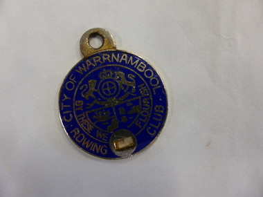
Badge - City of Warrnambool Rowing Club
The Warrnambool Rowing Club was formed in the 1880s when there was a renewed interest in rowing and many young men were taking up competitive rowing. The Warrnambool Rowing Club used the new boatsheds erected in 1885 by Fanny Nelson near the mouth of the Hopkins River where the Hopkins Hotel was operating (Simpson Street). This badge belonged to a member (number 333) in the 20th century but the name of the owner is unknown.This badge is of interest but has no provenance so is useful for display purposes onlyThis is a small metal badge enamelled in blue and silver. It has a loop at the top for attachment to a chain or pin and a hole at the bottom – another attachment device. The back is gold-sprayed. Front: City of Warrnambool Rowing Club, W.C.C. logo , ‘By These We Flourish’ Back: Not Transferable, 333, Taiwan warrnambool rowing club, warrnambool, fanny nelson -
 Warrnambool and District Historical Society Inc.
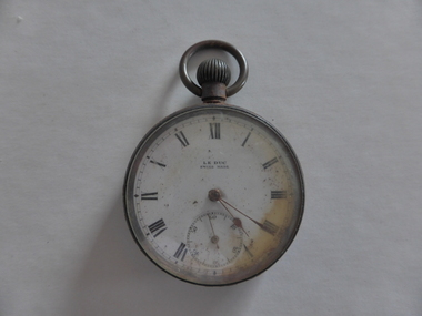
Watch, Watch from Nestor
This watch belonged to Norman Borthwick of Ecklin, who, with his wife and two children, Janet, aged 7 and Jack, aged 6, were survivors of the sinking of the cruise boat, Nestor, on the Hopkins River in January 1921. The boat was on its regular trip from the Hopkins River boatsheds to Jubilee Park with 80 passengers. Ten people were drowned when the boat began to take water and sank about a kilometre upstream. Norman Borthwick was wearing the watch at the time and the hands have stopped at 5.20 p.m. on the day of the tragedy. A hero of the day was Constable Sharrock who drowned after saving the lives of several of those on boardThis watch is of great significance as it is an item that belonged to Norman Borthwick who was wearing the watch when he survived the sinking of the Nestor in the Hopkins River in 1921. This was one of the great tragic incidents in Warrnambool in the early 20th centuryThis is a Swiss-made watch made of gunmetal with a glass face and a metal winder at the top and a ring to attach the watch to a chain. The figures are Roman numerals and there is a separate minute hand dial. The watch is much rusted and is not able to be easily opened to see the mechanism. The gold-coloured hands point to the time of 20 past 5. The face of the watch is discoloured on the right hand side.‘Le Duc, Swiss made’nestor sinking, norman borthwick, constable sharrock -
 Warrnambool and District Historical Society Inc.
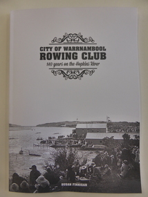
Book, City of Warrnambool Rowing Club, 2016
This book gives the history of the Warrnambool Rowing Club. The club was formed in 1873. In 1885 Mrs Fanny Nelson built a boathouse on the Hopkins River bank and leased it to the Warrnambool Rowing Club. A two-storeyed building for the Rowing Club was opened in 1889 and today the club operates from Proudfoot’s Boathouse near the mouth of the river. This is an important book as it details the history of the Warrnambool Rowing Club. Rowing has been a popular recreational pursuit in Warrnambool since the early days of settlement as the proximity of two rivers makes this possible and the Warrnambool Rowing Club has a history well worth recording. This is a soft-cover book of 85 pages with a white cover with a black and white photograph on the front of the old rowing club sheds on the Hopkins River and several images on the back cover of Warrnambool in the 19th century. The book has eight chapters and has pages with information on life members and committees, a Foreword, a Contents page, an Acknowledgements page, an Index and Endnotes. The book is written by Susan FinneganFront Cover: ‘City of Warrnambool Rowing Club, 140 Years on the Hopkins River’warrnambool rowing club, warrnambool -
 Warrnambool and District Historical Society Inc.
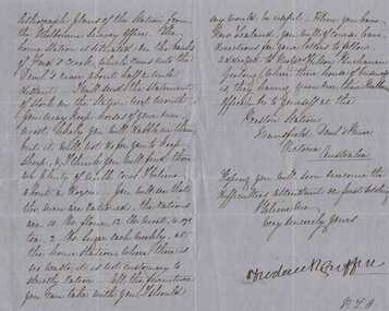
Letter, Frederick Griffin re moving to New Zealand
A letter written from Preston Estate telling of issues regarding conditions of station life. Preston station and Devil’s river are both in the vicinity of Mansfield in North East Victoria A letter which is typical of the time and as such has social and historical significance and interest.Blue paper hand written in black pen. Written front and back of paper. The signature is in a different hand.Signed Frederick Griffin preston estate, bostock, warrnambool -
 Warrnambool and District Historical Society Inc.
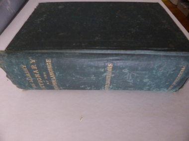
Book, The library dictionary of the Eng language
This dictionary belonged to John Brass, an early settler in South Warrnambool. He owned several block of land and operated a lighterage business with John Young. As a lighterman and boatman he was well-known in Warrnambool. He was drowned in March 1895 while attempting to cross a temporary foot bridge across the Merri River. His house (probably in Stanley Street) was built in 1868 and remained as an interesting example of a lighterman’s cottage until1974. The dictionary probably became the property of W. Macdonald after John Brass’ death. No information has been found on this W. Macdonald. This book is of interest as it belonged to John Brass, an important early settler in South Warrnambool. This is a hard cover book of 974 pages. The cover is green with embossed patterning and lettering on the front cover and gold lettering on the spine. The book has a Preface, a Contents page, the Dictionary entries and an Appendix. There are many illustrations, from engravings on wood, scattered throughout the text. The cloth binding is coming loose and there are several loose pages. The last page is missing. The inscriptions are written in pencil and in blue ink and there are red stamps of John Brass. The cover is stained and faded. ‘John Brass, South Warrnambool, Victoria, Aust- 1893’ ‘June 5 x 6 x 93’ ‘J.Brass, Jetty’ Stamps – ‘John Brass, South Warrnambool’ ‘W.J. Macdonald, Moyston, Dec.23-11-95’ ‘W.J.McDonald’ john brass, history of south warrnambool, w. macdonald (moyston), warrnambool’s maritime history -
 Warrnambool and District Historical Society Inc.
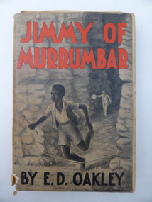
Book, Jimmy of Murrumbar by E D Oakley, 1938
This book subtitled, ‘A Story of the Amazing Ability and Fidelity of an Australian Black Tracker’, has been written in the late 1930s by Edward Daniel Oakley (1877-1962). He was the fourth child of Thomas and Eliza Oakley who had the farm, Oakbank, near the mouth of the Hopkins River, Warrnambool (Otway Road area today). Edward Oakley first worked at Saltau’s shipping office in Warrnambool then ran a dairy farm, Halifax, near Cudgee. He later had wheat farms in the Grampians area and at Willaura before returning to Warrnambool in 1923. He built a row of shops in Liebig Street and opened a boot and shoe store. He was instrumental in persuading Fletcher Jones to open a shop in Warrnambool. After he retired he researched and wrote the story of Jimmy of Murrumbar. This book is of high significance because: 1. It was written by a local Warrnambool businessman, Edward Oakley. He and other members of his family were prominent residents of the city in the late 19th and early to mid 20th centuries 2. It was written in the late 1930s and tells of the story of a young aboriginal boy, one of the early writings appreciating the talents and worth of young aborigines. This is a hard cover book of 181 pages. A buff-coloured dust cover has been pasted over the hard cover and it has a black, grey and white illustration of a young aboriginal boy being chased. This illustration is repeated in black and white on the second page. The titling on the cover is in red and black printing. The front cover has become almost detached from the pages. An inscription on the inside cover is handwritten in black ink. The book has a foreword, an appreciation, a contents page and 23 chapters. ‘Best Wishes for a Happy Birthday from Graeme Dorman Dec 8th 1942’ edward oakley, history of warrnambool, aboriginal literature, jimmy of murrumbar, thomas and eliza oakley -
 Warrnambool and District Historical Society Inc.
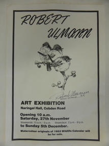
Poster, Poster for Robert Ulman exhibition, 1982
This is a poster advertising an art exhibition by the Warrnambool artist, Robert Ulmann. The exhibition was held in the Naringal Hall in November/December 1982. Robert Ulmann (1927-1999) was born in Zurich, Switzerland where he studied sculpture and painting. After living in Canada for some time he came to Australia in 1969. From 1970 to 1972 he was employed by the Northern Territory Administration as a manual arts instructor to the aboriginal people of Docker River west of Uluru. He exhibited extensively in city and regional galleries and won numerous awards for his artistic works. His love of wildlife extended to his interest in the Southern Right Whale and he was greatly responsible for publicizing the annual appearance of the whales at Logans Beach in Warrnambool and protecting their environment. His studio in Warrnambool is still visited by many tourists. This poster is of interest as it concerns an art exhibition of the work of Robert Ulmann, a well-known Warrnambool artist of the 20th century. This is a sheet of white paper with black edging. It is an advertisement for a Robert Ulmann Art Exhibition. The page has a sketch of three birds with Robert Ulmann’s signature underneath. robert ulmann, history of warrnambool -
 Warrnambool and District Historical Society Inc.
Book, John Ross notebook, 1890s
This small note book belonged to John Ross, the Warrnambool Town Surveyor and Engineer (1889-1906 & 1913-1914). The book lists the levels taken for the benefit of contractors undertaking jobs for the Warrnambool Council from 1898 to 1902. The jobs include ‘Russells Creek from the Merri River upwards’, ‘Outlet at the Flume’, ‘Guns at the Battery’ and Drainage from the Terminus Hotel to the end of the Japan Street Tunnel’. John Ross was also in private practice with the architectural firm of Ross and Jackman. This notebook is of considerable interest because it is an original note book that belonged to John Ross, the Warrnambool Town Surveyor and Engineer in the late 19h century and early 20th century. The note book contains important information on the engineering projects in Warrnambool and district from 1898 to 1902. This note book has a red leather cover. The cover is a little creased. The inside pages have ruled red lines and printed headings regarding the levels taken of a site and the location of the site (1898 to 1902). The engineer’s entries in the printed columns are handwritten , mostly in pencil. The inscription on the first page is handwritten in black ink. ‘Jno C Ross, Town Surveyor Wbool 19/5/98’ john ross, warrnambool town council, history of warrnambool -
 Warrnambool and District Historical Society Inc.
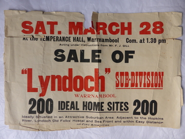
Poster, Lyndoch Sub-Division
This is a poster advertising the sale of the Lyndoch sub-division in Warrnambool with the sale of 200 housing sites. The sale took place about 1958 with the land sold by Frederick Gill, a Warrnambool jeweller. The land was previously owned by George Rolfe who had acquired the land near the mouth of the Hopkins River in the 1880s and named the property ‘Lyndoch’. He bought the surrounding land at a later time. This sub-division came to be known as the Gill Estate. It was a valuable site as many of the allotments fronted the sea and others were adjacent to the Hopkins River. This poster, although tattered, is of interest as it has many details of the Gill Estate sub-division and will be useful to researchers. This is a cream-coloured paper poster with black and red printing. The poster has a small map in a circle shape showing the location of the streets and a larger map section showing the streets and the allotments to be sold. The poster is in two pieces and the edges are torn and, in some sections, missing. The streets map has some pencil annotations. history of warrnambool, lyndoch, warrnambool, george rolfe, frederick gill -
 Warrnambool and District Historical Society Inc.
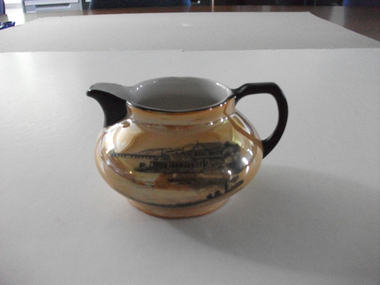
Jug, Souvenir Warrnambool Jug, Between 1921 and 1938
This is a souvenir jug showing an image of the boat sheds (Proudfoots) at the mouth of the Hopkins River, Warrnambool. It would have been purchased in the 1920s or 1930s. These boatsheds were erected for Thomas Proudfoot in 1885. At that time the sheds housed the boats of the local Gordon Rowing Club. This jug is of interest as an example of the type of souvenir available to tourists and locals in the Warrnambool district in the 1920s and 30s. This is a lustre ware china jug with a black handle and a black lip and black edging around the opening. The jug has a squat spherical shape and has gold colouring with an image in black and grey of the boatsheds at the mouth of the Hopkins River, Warrnambool. The lettering is in black and on the base are the maker’s symbols. ‘Boat Houses on the Hopkins, Warrnambool ’23 R.K.G. Made in Cechoslov (sic)’ proudfoots boatsheds. warrnambool, hopkins river, warrnambool, history of warrnambool -
 Warrnambool and District Historical Society Inc.
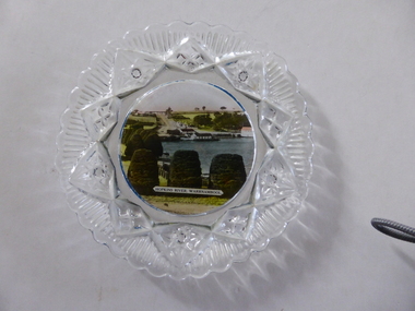
Platter, Transfer Hopkins River
This is a souvenir dish or small plate with an illustration of the Hopkins River in Warrnambool. Included in the illustration are the rowing shed, the boathouses and the lambertiana trees in the property of Lyndoch. The souvenir dish would have been sold to tourists visiting Warrnambool or Warrnambool residents in the 1920s and 30s. This type of souvenir was popular at the time in any tourist town or place in Australia. Tourism has been an important industry in Warrnambool since the late 19th century. This item is of interest as an example of the type of souvenir produced for tourists in the 1920s and 30s. It was both a useful and decorative item. It will be useful for display. This is a small glass souvenir dish. The centre of the dish features a colour illustration of the Hopkins River, Warrnambool (near its mouth). The glass around the illustration is heavily patterned and embossed. The bottom of the dish is dark blue. ‘Hopkins River Warrnambool’ tourism in warrnambool, warrnambool history -
 Warrnambool and District Historical Society Inc.
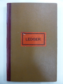
Document - Ledger, Standard Articles, Mid 20th century
This ledger contains original Warrnambool Standard newspaper cuttings of the eleven articles written by Henri Worland on the early history of Warrnambool. The subject matter includes the Post and Telegraph Office, Punts over the Merri and Hopkins Rivers, Transport in the Early Days, Early Exploration, Minjah Station and the History of the Breakwater. Henri Worland (1883-1972) was Warrnambool’s most important 20th century local historian. He was the Town Clerk of Warrnambool from 1918 to 1949 and his intense interest in Warrnambool’s history led him to collect and preserve a great amount of local history material. He wrote extensively on Warrnambool’s history and gave talks on the local radio station over a period of many years.These newspaper cuttings are of interest as examples of the many local history articles written by the important Warrnambool historian Henri Worland. The Warrnambool and District Historical Society has a collection of Worland’s original writings in his own handwriting. This is a ledger book with a brown-coloured cover with red binding. There is a label pasted on to the front cover with black printing on it. The ledger has indented alphabet tabs and the pages are ruled with red lines for ledger purposes but these have not been used. The ledger has been used to paste in original cuttings from the Warrnambool Standard newspaper (Henri Worland articles from the 1940s). One page contains two copies of old photographs. Some of the pages have been reinforced with staples and some pages have become detached from the binding. ‘Ledger’ henri worland, history of warrnambool -
 Warrnambool and District Historical Society Inc.
Document, Wollaston sale, 1919
This is a poster advertising the sale of part of the Wollaston Estate in Warrnambool in 1919. The sections for sale were Allotments 1, 18 and 19 which included the Wollaston Homestead. The original Wollaston property of 679 acres was selected by Thomas Manifold in the late 1840s. This land, on the northern side of the Merri River, near the Woodford Road was three kilometres from the Warrnambool town. The first farmer we know who leased the property was William Simpson. Walter Manifold inherited the property and he took it over in 1884. The swing bridge he built in 1890 still stands today. In 1919 the Closer Settlement Board of Victoria acquired Wollaston and 17 lots were sold to returned soldiers for farming purposes. By 1930 there were only five soldier settlers remaining. In 2009 further subdivision took place with lots sold for residential purposes. The homestead allotments were sold separately in 1919 with various owners of the homestead itself recorded since that time. This poster is of interest as it shows the areas of the Wollaston Estate which were sold in 1919. The history of this estate is well-documented and of importance in the history of Warrnambool. This is a sheet of paper with red and black printing and a map of the Wollaston Estate which is photo-lithographed. The sheet has been folded three times. It has some small tears at the top of the page. wollaston, history of warrnambool, walter manifold -
Warrnambool and District Historical Society Inc.
Sale Poster, Mercer Print, "Arran" 1967, 1967
This Auction notice is for the sale of an Ellerslie property called "Arran" , owned by Mr Philip M. Ormsby. The date of the auction is Thursday 16th February 1967. Vendors solicitors are Archer Naughtin and Forrest of Mortlake and the sale agents are Dennys, Lascelles Limited. Portions of "Arran" had been in the family since 1865. The property has 3/4 mile frontage to the Hopkins river.This sale notice is of general interest as a well established property in a good farming region. Long sheet with sale details of the property Arran The majority of the text is black with some highlighted in red.There is a map of the property on the reverse.warrnambool, arran, ellerslie -
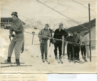 Kiewa Valley Historical Society
Photographs – Skiers at Falls Creek – Set of 10 black and white photographs
After World War II, the Kiewa Hydro-Electric Scheme was started in the Kiewa River valley by the State Electricity Commission of Victoria. On land previously used only for summer cattle grazing in the natural alpine grasslands, the first ski lodge was built in 1948 by workers from the hydro scheme as skiing was a popular recreation. Many of the hydro employees were of European background and had grown up enjoying skiing and snow sports in their homelands and were keen to continue to pursue their winter sports interests. The first lift, a rope tow, was built in 1951 and the first chairlift in Australia was constructed there in 1957. Two T-Bars were opened in 1961. In 1964, the Victorian Municipal Directory recorded that Falls Creek had 29 ski club lodges and 16 commercial lodges.Employees of the State Electricity Commission of Victoria in the Kiewa River Valley were the earliest skiers on the Bogong High Plains and built one of the first ski lodges at Falls Creek. They were amongst those pivotal in the development of the skiing and tourist industry at Falls Creek and on the Bogong High Plains. Set of 10 black and white photographs of various skiers at Falls Creek Victoria1. From Left-John Robertson Myrtleford; Bill Bridgford, St Trinians; Girl not known; Roy Wolpole, Myrtleford; Fin McAuliffe, Myrtleford; Looking on foreground, Toni St Elmo 2. Falls Creek. Property of State Electricity Commission of Victoria Publicity Photo Negative No PB4046. Publicity Branch, 15 William St Melbourne. 3. Avic Lajons 4. No markings 5. Bill Bridgeford (lower person on slope) 6. Max Lawrence? Facing skiers 7. 6575. Indistinguishable red stamp on back 8. 6875. Ces Dobson on tractor 9. From left on tow. John Robertson (Myrtleford); Bill Bridgeford (St Trinians); Girl unknown; Roy Walpole (Myrtleford); Vin McAuliffe (Myrtleford); Looking on foreground Toni Beveridge. 10. From Left 1; 2; 3. Bill Bridgeford; 4. George McPherson ? (Myrtleford); 5. John Robertson (Myrtleford); 6. Elsbeth Rollenson? (Myrtleford); 7; 8; 9. 11. Bogong. Looking N.E from Big River fire track. Skiers on way to Falls Creek. Spion Kop on left. Going around Ropers Cerner near the 18 mile post falls creek, skiing, bogong high plains -
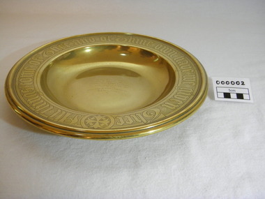 Christ Church Anglican Parish of Warrnambool
Plate, Untitled, Brass Alms dish, C.1902
Brass Collection Plate presented to St Paul's Anglican Church, Allansford, by the mother of Joseph & Frank Dallimore as a Memorial to the two brothers who drowned at Ryan's Den (near Cape Otway) on Jan 1st 1903. Major Joseph Dallimore (aged 32) was on leave from Sth Africa during the war and he, his wife (Beatrice Wiggs) and baby, his brother Frank Rupert Dallimore (aged 22), a farm hand Arthur Geach (aged 19) and a house maid servant, were picnicing at Ryan's Den (near Cape Otway) when the three men went walking, but never returned, all assumed drowned. One theary has it - Mrs M.E. Dallimore was picnicing at Lake Gillear beach when an enormous wave swept over the shore - (much larger than any other during that day) and rolled in all along the beach. This wave may have also reached the area where the three men were walking on the rocks and swept them into the ocean. Only one body was recovered - some 4 weeks later - that of Frank Rupert Dallimore and washed into Brown's Creek, 1 mile from the Johanna River and ten miles east of Ryans Den.It is a memorial plate and records the family's attachment and importance to the Church.Brass engraved and embossed Memorial Collection PlateEmbossed wording around edge of plate in Old English font reads - "All things come of Thee and of Thine own have we given Thee". The inscription on the tondo of the plate reads - "TO THE GLORY OF GOD / AND IN MEMORY OF / JOSEPH & FRANK RUPERT DALLIMORE, / WHO WERE DROWNED AT RYAN'S DEN, / JAN 1ST 1903. / PRESENTED BY THEIR LOVING MOTHER, / M.E.DALLIMORE."brass st pauls anglican church allansford warrnambool church of england christ church parish of warrnambool collection plate memorial plate dallimore drowning ryan s den alms dish -
 Warrnambool and District Historical Society Inc.
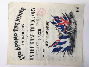
Leisure object - Sheet music, On the road to victory, 1941
This piece of music has been produced during World War Two (1941) as a propaganda and fund-raising piece for the people of Alexandria in Egypt. It has both Greek and British backing with the headings on the cover in both languages. The music is a march and the title suggests that victory is on the way so the emotions are being stirred to keep up the morale. Egypt in World War Two was still under British influence and Alexandria is a port in Egypt at the mouth of the Nile River. In 1941 British battleships were based in the Alexandria harbor and two of them were disabled by Italian Navy divers. Hence it is not clear why it was the Hellenic (Greek) Red Cross raising funds for Alexandria through the sale of this music which was produced in that city by the Moharrem Press (founded 1938) and composed by Lena Bonfiliou, probably a Greek person. It is not known if this piece of music was bought in Australia or brought back to Australia by an Australian military person during World War Two.This is an interesting piece of music. Its connection to Warrnambool is not known but it is an example of the type of music produced during World War Two to help the war effort. This is a four page piece of music, ‘On the Road to Victory’ (a march) with a front cover, a blank end page and two pages of musical notation. The latter pages have black printing on white pages. The front cover has both Greek and English printing and a colour image of four British and Greek flags resting on a gun carriage with armaments underneath and indications of an explosion. There is a red stamp on the cover (Hellenic Red Cross). The pages are in good condition. English printing: ‘On the Road to Victory, March, P12’ Stamp: ‘For the Hellenic Red Cross, Alexandria’ alexandria, hellenic red cross, warrnambool, on the road to victory music