Showing 120 items matching "topographical maps"
-
 Federation University Historical Collection
Map - Geological, Tallangatta, New South Wales: 1:250,000 Geological Series, SJ 55-3, 1966, 1966
Compiled by the Geological Survey of N.S.W., Division of Regional Geology. Topographical base compiled from Snowy Mountains Hydro Electrical Authority, Department of Lands, County maps and Snowy Lease Map. Other sheet adjoin this map. There are 13 formation sections grouped into 9 - Quaternary, Tertiary, Middle Devonian, Lower to Middle Devonian, Lower Devonian, Upper Silurian, Silurian, Upper Ordovician and Ordovician.Large coloured map showing geological features, faults, bores, rivers and mineral deposits.Scale of map, longitude and latitude, river names. "Tallangatta 1:250,00" written in black pen.tallangatta, new south wales, geological survey, topographical base, snowy mountains hydro electrical authority, department of lands, snowy lease map, department of mines, quaternary, tertiary, middle devonian, lower to middle devonian, lower devonian, uper siluran, silurian, upper ordovician, ordovician -
 Orbost & District Historical Society
book, Effingham, Wilson, A Geographical Dictionary of the Australian Colonies, 1848
A geographical dictionary or gazetteer of the Australian colonies : their physical and political geography : together with a brief notice of all the capitals, principal towns, and villages. William Wells travelled to Australia as a sponsored immigrant in 1838. Her became a freelance surveyor with an office in Bligh Street, Sydney. He wrote this book in order to better inform the British public on the colonies of Australia. The information contained in the book is both topographical and statistical and was a very useful refernece book at the time.This book is a rare detailed contemporary record of the Australian colonies in the mid 19th century.A hard back 453 pp book with a dark brown patterned cover which has a white label with the title, "Dictionary of Geography" over a map of Australia. It is illustrated with numerous maps and drawings.history-australia wells-william-henry geographical-dictionary-of-the-australian-colonies -
 Federation University Historical Collection
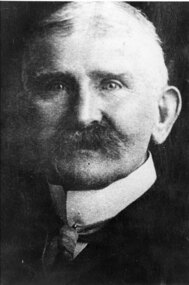
Photograph - Photograph (black & white), Ferdinand Moritz Krause
Civil engineer and geologist Ferdinand Moritz Krause lecturered at the Ballarat School of Mines from 1880 to 1895. He was born at Kassel, Germany on 24 February 1841, the youngest son of Frederich Wilhelm Krause. Ferdinand Krause married Amy Augusta Dimock. He died in South Africa 16 June 1918. In June 1880 Krausé was appointed to the Ballarat School of Mines as lecturer in 'geology, palaeontology, mineralogy, electricity, magnetism, scientific mining, geological and topographical surveying' and as museum curator. In 1881 he was appointed Professor of Geology and in 1892 was elected president of the Staff Association. He was held in high repute by his students and also known as a keen musician. He resigned from the School of Mines to be lecturer in mining at the University of Melbourne from June 1895 to January 1897. Whilst at Ballarat in 1887-90 he had completed geological maps and reports on the parishes of Haddon, Carngham, Scarsdale, Lillerie, Smythesdale and Comeralghip; these were published in 1898. The Institute of Surveyors elected him a member in 1891. His Introduction to the study of Mineralogy for Australian readers was published in Melbourne in 1896. In January 1897 he became manager of the General Gordon mine near Kalgoorlie. In 1900 he contributed an article to the Ballarat School of Mines Students' Magazine on the mining geology of Kalgoorlie. Invited by a former student, George Denny, Krausé left for South Africa in 1901. His last work was a geological map of the Barberton area, Transvaal, published in March 1918. He died on 16 June, survived by his wife, three sons and a daughter. (http://adb.anu.edu.au/biography/krause-ferdinand-moritz-3971, accessed 20 November 2018) Black and White photograph of the head and shoulders of Professor Ferdinand Krause of the Ballarat School of Mines.ballarat school of mines, ferdinand krause, geology, fm krause, krause, ballarat school of mines museum -
 Federation University Historical Collection
Map, Topographical Map Creswick A & B
... Topographical Map Creswick A & B... Topographical Map Creswick A & B Map Map Department of Lands and Survey ...Printed map on papercreswick, clunes, lexton, waubra, smeaton -
Federation University Historical Collection
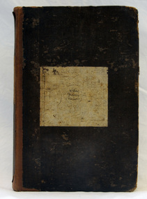
Map, Creswick Gold Field Map, 1981
A fragment of the original 1880 map is also held in the collection. See 116Rectangular geological map with brown paper strip on top edge with 4 holes on top edge. Scale is 40 chains to one inch.Geologically and topographically surveyed by Ferdinand M Krause. Lithographed by R. Shepherd. Printed by J. Finnie. Mining Department, Melbourne. Preprinted with additional shaft and lead detail. F. D. Atkinson, Government Printer 1981creswick, krause, surveyor, smeaton, spring hill, tourello, ascot, dean, bullarook, gold fields, gold -
 Federation University Historical Collection
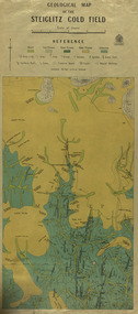
Map, Geological Map of The Stieglitz Gold Field, 1940
At the bottom of the 2nd page, there is text that reads "Geologically and topographically surveyed in 1909 by W.H. Ferguson, Assistant Field Geologist. Published 1940."Rectangular geological map edged in masking tape showing Steiglitz, Victoria. Scale 48 chains to 4 inches.steiglitz, geology, geological map, north albion, moreep, mining, mine, caribald reef, durdidwarrah, gilbraltar hill, mount pleasant gully, township of steiglitz, w.h. ferguson, garibaldi reef, yankee gully, kinglock mine engine shaft, herbert werner frederick de nully, albion gully, virago reef, mulrooney's reef -
 Coal Creek Community Park & Museum
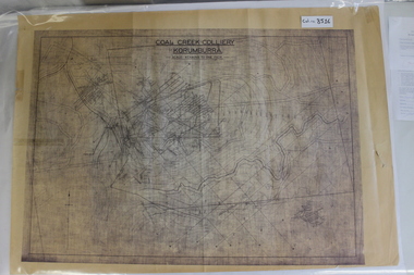
Map of Mine and Details, Coal Creek Colliery Korumburra
8516.1 - Schematic/map of coal creek mine workings, also detailing number surface features such as topographic heights, roads, railways, boreholes, etc. No Legend. Most information seems to be printed, with topography drawn on. -
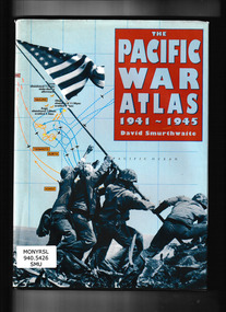 Monbulk RSL Sub Branch
CIS, The Pacific War Atlas 1941-1945, 1995
... than 60 full-color maps combining topographical detail ...Traces the campaign in the Pacific in detail, from its conception through the dropping of the atomic bombs on Hiroshima and Nagasaki. It brings a new clarity to the disposition of military units in all major battles and to the complicated web of strategic problems posed by fighting over such a huge area. Special map projections, perspective views and sophisticated treatment of time phases recreate the action from both Allied and Japanese viewpoints. Includes more than 60 full-color maps combining topographical detail with troop movements.Index, bibliography, ill, maps, p.141.non-fictionTraces the campaign in the Pacific in detail, from its conception through the dropping of the atomic bombs on Hiroshima and Nagasaki. It brings a new clarity to the disposition of military units in all major battles and to the complicated web of strategic problems posed by fighting over such a huge area. Special map projections, perspective views and sophisticated treatment of time phases recreate the action from both Allied and Japanese viewpoints. Includes more than 60 full-color maps combining topographical detail with troop movements. world war 1939 – 1945 – campaigns – pacific ocean, world war 1939 – 1945 – campaigns – pacific ocean - maps -
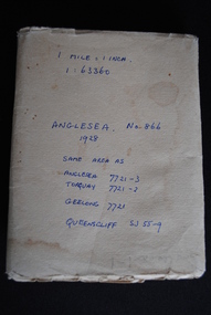 Anglesea and District Historical Society
Map, Royal Australian Survey Corps, Anglesea, Victoria, 1954
... Anglesea great-ocean-road anglesea map topographic map (See above ...Anglesea, Victoria [cartographic material] produced by Royal Australian Survey Corps. Colour; Scale [1:63,360] 1 mile to 1 inch; transverse Mercator projection; Sheet No. 866, Zone 7. Two stamps: 1. Rankine and Dobbie Pty Ltd. 2. Authorised for sale / Price 2/- / By Department of the Army Original date: November 1928.(See above)anglesea map, topographic map -
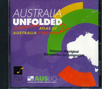 Victorian Aboriginal Corporation for Languages
CD-ROM, Australian Surveying and Land Information Group, Australia unfolded : interactive atlas of Australia, 1996
... Street Brunswick melbourne topographic maps Australian maps ...Systems requirements: Macintosh version: Mac Plus (68030 or higher recommended), 5 MB hard disk space, 2 MB RAM (4 MB RAM recommended), CD-ROM drive, mouse, System 7 or above. "9314231106006"--CD-ROM. System requirements: Windows version: IBM compatible 386 or higher, 5MB hard disk space, 4MB RAM (8MB RAM recommended), VGA monitor, CD-ROM drive, mouse, Windows 3.1 or above. In box (19 x 27 x 5 cm.).CD-ROMtopographic maps, australian maps, surveying -
Clunes Museum
Map - SURVEYERS MAP OF CLUNES, J. FINNIE, 1883
A SURVEYORS MAP OF CLUNES. GEOLOGICALLY AND TOPOGRAPHICALLY SURVEYED BY R.A.F. MURRAY.LITHOGRAPHED BY R. SHEPHERD AND PRINTED BY J. FINNIE MINING DEPARTMENT, MELBOURNE,1883document, surveyers map of clunes, map of clunes -
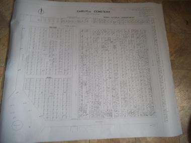
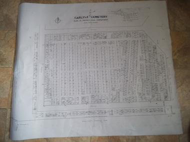 Rutherglen Historical Society
Carlyle Cemetery Map, Plan of Presbyterian Compartment, 1952
This is a map produced to attempt to bring order to the cemetery. Originally the layout was not well defined and it is difficult to use this plan to locate a particular grave, also the fact that not all graves are marked and foot paths are not defined has exacerbated this issue. Photocopy, White paper, black printing, black line work showing lot and compartment boundariesReferences Grid Survey points at 50 feet centres shown (as a cross with the reference mark number in brackets) Lot Number shown at left side of graves. Burial Number shown at right side of grave. Lots with unidentified burials show with dashed cross with in the lot. topographic survey, cadastral survey, carlyle cemetery, burials, graves, lot boundary, rotunda -
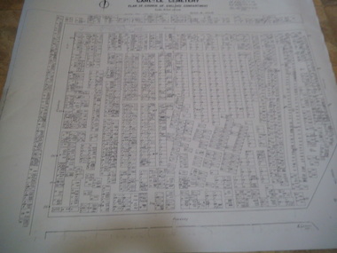
 Rutherglen Historical Society
Carlyle Cemetery Map, Plan of Roman Catholic Compartment, 1952
This is a map produced to attempt to bring order to the cemetery. Originally the layout was not well defined and it is difficult to use this plan to locate a particular grave, also the fact that not all graves are marked and foot paths are not defined has exacerbated this issue. Photocopy, White paper, black printing, black line work showing lot and compartment boundariesReferences Grid Survey points at 50 feet centres shown (as a cross with the reference mark number in brackets) Lot Number shown at left side of graves. Burial Number shown at right side of grave. Lots with unidentified burials show with dashed cross with in the lot. topographic survey, cadastral survey, carlyle cemetery, burials, graves, lot boundary, rotunda -
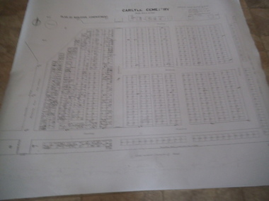
 Rutherglen Historical Society
Carlyle Cemetery Map, Plan of Church of England Compartment, 1952
This is a map produced to attempt to bring order to the cemetery. Originally the layout was not well defined and it is difficult to use this plan to locate a particular grave, also the fact that not all graves are marked and foot paths are not defined has exacerbated this issue. Photocopy, White paper, black printing, black line work showing lot and compartment boundariesReferences Grid Survey points at 50 feet centres shown (as a cross with the reference mark number in brackets) Lot Number shown at left side of graves. Burial Number shown at right side of grave. Lots with unidentified burials show with dashed cross with in the lot. topographic survey, cadastral survey, carlyle cemetery, burials, graves, lot boundary, rotunda -
 Rutherglen Historical Society
Carlyle Cemetery Map, Plan of Wesleyan Compartment, 1952
This is a map produced to attempt to bring order to the cemetery. Originally the layout was not well defined and it is difficult to use this plan to locate a particular grave, also the fact that not all graves are marked and foot paths are not defined has exacerbated this issue. Photocopy, White paper, black printing, black line work showing lot and compartment boundariesReferences Grid Survey points at 50 feet centres shown (as a cross with the reference mark number in brackets) Lot Number shown at left side of graves. Burial Number shown at right side of grave. Lots with unidentified burials show with dashed cross with in the lot. topographic survey, cadastral survey, carlyle cemetery, burials, graves, lot boundary, rotunda -
Beechworth Honey Archive
Topographic Map, Beechworth, Australia
... , Wooragee and Eldorado. Topographic Map, Beechworth, Australia ...Map 1:50,000. Sheet 8225-111 Printed by Royal Australian Survey Corp, 1967. Map includes Beechworth, Everton, Muirmungee, Wooragee and Eldorado. -
Beechworth Honey Archive
Map- Albury
Map centred on Albury, showing Wodonga, Beechworth, Yackandandah and Chiltern. Topographic survey scale 1:100,000. Map is colour, printed on paper. Produced by Department of Minerals and EnergySheet 8225 (ed.1) series R. 652 Notes written on side regarding brigade boundaries, constructed access roads and fire trails, dams suitable for quick fill pump and areas 'fuel reduction burns Autumn 76'.map, albury, wodonga, beechworth, yackandandah, chiltern, paper, topographic, beechworth honey -
Tarnagulla History Archive
Photocopies of historic maps - Tarnagulla region, varied
David Gordon Collection. Four photocopies in clear sleeve: (a) topographic with mines near Tarnagulla (b) Parish map ?- Tarnagulla & surrounds (c) Parish map ?- Tarnagulla & surrounds (d) Plan of Roads, Tarnagulla & Newbridge -
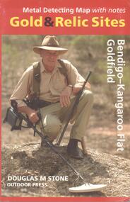 Bendigo Historical Society Inc.
Map - METAL DETECTING MAP WITH NOTES: GOLD AND RELIC SITES - BENDIGO KANGAROO FLAT GOLDFIELD
BHS CollectionMap of the Bendigo and Kangaroo Flat Goldfields with key to diggings, structures, locations of nuggets previously found and topographical features. Enclosed in a coloured cardboard cover with photograph of gold detector.Douglas M Stone, Outdoor Pressmap, bendigo, goldfields -
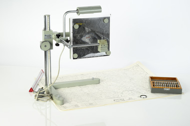 Department of Energy, Environment and Climate Action
Zeiss Sketchmaster
The Zeiss Sketchmaster was used to transfer information from aerial photographs onto scale maps. The operator views the aerial photograph and the map simultaneously and manually traces detail from the photograph onto the map. It utilises the principle of the camera lucida, patented in 1806. Various lens combinations were used on a to adjust for scale and then “rubber sheet” the image to line up topographic features like streams and roads. The photo information was then laboriously transferred using a light table onto large A0 paper maps or translucent drafting film. The maps were later hand coloured with either Derwent pencils or delicately painted with Pelikan ink wash. This item is kept at Erica.Zeiss Sketchmaster. c1970s. Includes adjustable stand, various lens in sperate box, adjustable light, map holder and magnetsforests commission victoria (fcv), forest measurement, mapping, surveying -
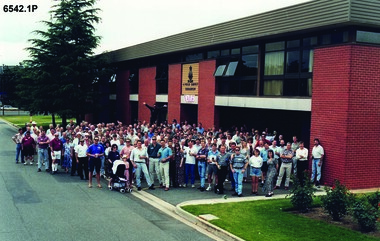 Bendigo Military Museum
Photograph - 4 Fd Svy Sqn Closure Ceremony 25 Nov 1995, 4 Fd Svy Sqn, Keswick Barracks, Adelaide, 25.11.1995
Between 1915 and 1951, military topographical mapping in SA was conducted by Royal Australian Survey Corps (RASvy) units based outside the state. In February 1952, Army HQ Field Survey Section (Central Command Detachment) was established in Adelaide in a drill hall at Largs Bay. It was tasked with providing map coverage in the Woomera and Southern areas of the state. The section was subsequently reorganised as Central Command Field Survey Section moving firstly to Hampstead Barracks, Hampstead in 1953 and then into accommodation at Keswick Barracks in 1954. In 1957 the Section commenced mapping operations in the NT. The Unit was relocated to the old cavalry stables in 1961 and was redesignated Central Command Survey Unit and remained there till 1973. In 1970 the Unit was redesignated 4 Fd Svy Sqn and engaged in operations conducted in PNG from 1972 to 1974 inclusive. In 1973 the Squadron moved into a brand new two-storey specially designed and purpose built building adjacent to the old building. The old building then became the Squadron Q and Map store with an interconnecting lobby to the new building. Since 1975 the Unit was involved in the 1:50,000 Mapping Programme in WA, NT, QLD, SA and conducted many other operations within Australia and overseas. Post disbandment of the Corps the old Squadron building (cavalry stables) now houses the Army Museum of South Australia (AMOSA). The Royal Australian Survey Corps was amalgimated into the Royal Australian Engineer Corps in July 1996. In the lead up to this amalgamation, 4 Field Survey Squadron Keswick Barracks, Adelaide, South Australia was disbanded in 1995. A closing Ceremony was held on 25 November 1995 at 4 Fd Svy Sqn Keswick Barracks attended by about 208 former members of the Unit. A photo was taken of attendees at that event on the day and a list was prepared of attendees. All attendees were sent a copy of the photograph and the list of names as a momento of the Unit and the ceremony..1P A4 Print of an original photo of attendees at the 4 Fd Survey Sqn Closure Ceremony at Keswick Barracks 25 Nov 1995. .2P A4 Print of the names of the attendees at the 4 Fd Survey Sqn Closure Ceremony at Keswick Barracks 25 Nov 1995. Approx 208 attendees.royal australian survey corps, rasvy, fortuna, army survey regiment, army svy regt, asr, 4 fd svy sqn -
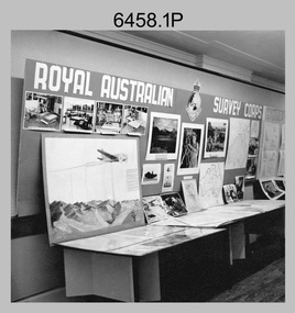 Bendigo Military Museum
Photograph - Royal Australian Survey Corps role and technical capabilities display, c1960s
This is a collection of four photographs taken in the 1960s of Royal Australian Survey Corps displays promoting its role and technical capability to acquire, process and disseminate topographic information to the Australian Defence Force. Map products formed a large part of this topographic Support. The photos may have been taken at a Careers Expo or a Department of Defence promotion. It is possible the photos were taken at separate events. This is a collection of four photographs taken in the 1960s of Royal Australian Survey Corps displays promoting its role in Defence and technical capabilities. The black and white photographs were printed on photographic paper and are part of the Army Survey Regiment’s Collection. The photographs were scanned at 300 dpi. .1) to .4) - Photo, black & white, 1960s. Royal Australian Survey Corps Display at unknown location.There are no annotations.royal australian survey corps, rasvy, army survey regiment, army svy regt, fortuna, asr -
 Bendigo Military Museum
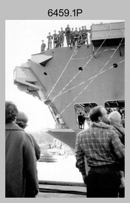
Photograph - A Section, 1st Topographic Survey Troop, Vung Tau, Vietnam, 1966
This is a set of 12 photographs of A Section, 1st Topographic Survey Troop taken from the 25th of May to the 12th of June 1966 during their deployment to Vung Tau, Vietnam. Led by OC CAPT Bob Skitch, the ten personnel from A Section 1st Topo Svy Tp and six personnel from supporting units were the first contingent from the Royal Australian Survey Corps deployed to provide topographic support to the Australian Task Force in Vietnam. They arrived in Saigon, Vietnam on the 10th of June 1966 enroute to the Australian Reinforcement Unit (ARU) “back beach” camp in Vung Tau. The ten RA Svy technical personnel from 1st Topo Svy Tp deployed were: WO2 David Christie, SGT Stan Campbell, SGT Dave King, CPL Jim Roberts, CPL Dennis Duquemin, CPL Des Ceruti, SPR Derek Chambers, SPR Brian Firns, SPR Joe O’Connor and SPR Ron Smith. External personnel deployed were: WO2 Snow Rollston from Northern Command Field Survey Unit, T/CPL Peter Clarke – orderly room corporal, T/CPL Alan Carew – Technical Storeman, SPR Stan Johns – Map Storeman, SPR Boots Campbell – batman/driver and PTE BNF Brunning – cook. The ship featured in photos .1P and .2P was the aircraft carrier HMAS Sydney on its 4th voyage to Vietnam. On board were SGT Stan Campbell and SPR Brian Firns, tasked to manage A Section’s stores and equipment. The rest of A Section deployed to Vietnam by air on the chartered Qantas 707B ‘City of Longreach'. A Section’s main tasks were to establish a Theatre Grid, map compilation and map revision; Engineer Survey Support in the camp and to the civil community; give assistance to the Cordon Search Missions by producing large scale plots from aerial photos with every house and fence etc plotted; and then reproduce these by silk screening usually, within a 24-hour period. RA Svy’s support concluded with the withdrawal of Australian troops from Vietnam in 1972. More information on the A Section, 1st Topographic Survey Troop and the Army Survey Regiment’s supporting role is provided in pages 89 to 94 of Valerie Lovejoy’s book 'Mapmakers of Fortuna – A history of the Army Survey Regiment’ ISBN: 0-646-42120-4.This is a set of 12 photographs of A Section, 1st Topographic Survey Troop (1st Topo Svy Tp), taken from the 25th of May to the 12th of June 1966 during their deployment to Vung Tau, Vietnam. The black and white photographs were printed on photographic paper and are part of the Army Survey Regiment’s Collection. The photographs were scanned at 300 dpi. .1) &.2) - Photo, black & white, 1966. HMAS Sydney departing Woolloomooloo wharf en-route to Vietnam. .3) - Photo, black & white, 1966. A Section 1 Topo Svy Tp relaxing in a bar before deployment. OC CAPT Bob Skitch in centre of photo. .4) - Photo, black & white, 1966. Unidentified A Section 1 Topo Svy Tp personnel and troops from other units relaxing in a bar before deployment. .5) - Photo, black & white, 1966. A Section 1 Topo Svy Tp personnel arrival by bus at Saigon (Tan Son Nhut) Airport. OC CAPT Bob Skitch 4th from right. .6) - Photo, black & white, 1966. A Section 1 Topo Svy Tp personnel boarding the USAF Hercules aircraft enroute from Saigon (Tan Son Nhut) Airport to Vung Tau Airfield. OC CAPT Bob Skitch on left. .7) - Photo, black & white, 1966. A Section 1 Topo Svy Tp personnel and troops from other units boarding the USAF Hercules aircraft enroute from Saigon (Tan Son Nhut) Airport to Vung Tau Airfield. .8) & .9) - Photo, black & white, 1966. A Section 1 Topo Svy Tp personnel arrive at the Australian Reinforcement Unit (ARU) “back beach” camp. .10) - Photo, black & white, 1966. A Section 1 Topo Svy Tp personnel in oppressive conditions work on map products. .11) - Photo, black & white, 1966. Group photo of A Section 1 Topo Svy Tp. OC CAPT Bob Skitch on far right. .12) - Photo, black & white, 1966. Group photo of A Section 1 Topo Svy Tp. OC CAPT Bob Skitch 3rd from right.Annotated with the photo set - ‘ DET 1 Topo Svy Tp Vung Tau 25 May to 12 of Jun 66’royal australian survey corps, rasvy, army survey regiment, army svy regt, fortuna, asr, 1st topographical survey troop -
 Bendigo Military Museum
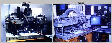
Photograph - AUTOMAP 2 Production - Army Survey Regiment, Fortuna, Bendigo, c1986
This collection of 23 photos of map production on the AUTOMAP 2 computer-based system in Air Survey and Cartographic Squadrons, was most likely taken in 1986. The AUTOMAP 2 system was an upgrade to the AUTOMAP 1 system, comprising Intergraph graphic edit workstation terminals networked to VAX 750/785 main frame computers. Unlike AUTOMAP 1, operators could display digital topographic features on monitors for editing. Successful adaptation of this system meant RASvy was at the forefront of digital mapping/cartographic systems in Australia and overseas. The system comprised Input (Wild B8 Aviograph feature extraction) Raster Scanning (digitising from compilation sheets, Graphic Edit (cartographic completion) and Plot Verification Sub Systems. The system was operational from 1984 to its ‘Newheart’ upgrade in 1993. Throughout its life, the system was progressively refined with productivity gains, achieved from award winning technical development in-house by talented and innovative Army Survey Regiment personnel.This is a set of 23 photograph of AUTOMAP 2 production at the Army Survey Regiment at Fortuna, Bendigo, c1986. The photographs were on 35mm colour slides and were scanned at 96 dpi. Photos .5P and .6P are also printed on photographic and scanned at 300 dpi. They are part of the Army Survey Regiment’s Collection. .1) - Photo, colour, c1986, AUTOMAP 2 Production - Army Survey Regiment, Fortuna, Bendigo. c1986. .2) - Photo, colour, c1986, AUTOMAP 2 Wild B8 Aviograph stereoplotter. .3) - Photo, colour, c1986, AUTOMAP 2 Wild B8 Aviograph stereoplotter feature extraction, unidentified technician. .4) - Photo, colour, c1986, Wild B8 Aviograph stereoplotter feature extraction, LCPL Raelene (Munting) Brodie. .5) - Photo, colour, c1986, AUTOMAP 2 computer tape maintenance, SPR Steve Linane. .6) - Photo, colour, c1986, AUTOMAP 2 Graphic Edit Workstation, SPR Steve Linane. .7) to .8) - Photo, colour, c1986, AUTOMAP 2 Graphic Edit Workstation, unidentified technician. .9 to .10) - Photo, colour, c1986, AUTOMAP 2 Graphic Edit Workstation. .11) - Photo, colour, c1986, AUTOMAP 2 Graphic Edit Workstation feature coding and command menu. .12) - Photo, colour, c1986, AUTOMAP 2 high resolution computer monitor. .13) to .16) - Photo, colour, c1986, AUTOMAP 2 production output comparison to AUTOMAP 1. .17) to .18) - Photo, colour, c1986, AUTOMAP 2 computer system components. .19) - Photo, colour, c1986, AUTOMAP 2 Intergraph 7596 verification plotter. .20) - Photo, colour, c1986, AUTOMAP 2 Benson verification plotter, SPR Steve Coulson. .21) - Photo, colour, c1986, AUTOMAP 2 drainage, contour, roads and cultural digital data verification plot. .22) - Photo, colour, c1986, AUTOMAP 2 drainage, contour, roads and cultural digital data on computer monitor. .23) - Photo, colour, c1986, AUTOMAP 2 3D digital terrain model on computer monitor. .1P to .23P - Some of the equipment is annotated on the frame of the 35mm slides. .5P & .6P prints annotated incorrectly ‘Steve Lenane’. Correct spelling is - ‘Steve Linane’ royal australian survey corps, rasvy, army survey regiment, army svy regt, fortuna, asr, automap 2 -
 Bendigo Military Museum
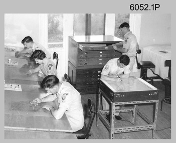
Photograph - Scribing at the Army Survey Regiment, c1950s to 1979
These 10 photographs were taken over two decades from the late 1950s to 1979 at the Army Survey Regiment, Fortuna, Bendigo. The two photos taken in 1961 are annotated with named personnel and the date. The other photos are not annotated with dates, locations and names of personnel, although the technicians in the last three photos taken in 1979 are positively identified. The photos were most likely taken in the Ballroom, Ante Room and Attic, Cartographic Squadron’s main production rooms on the top floor of Fortuna Villa. Scribing was the cartographic process of drafting topographic features such as drainage, relief, vegetation, roads and culture on specially coated map reproduction material. The cartographic technician scribed out the map feature such as a creek to a specified line width on the map sheet, using a tool affixed with a metal or sapphire tipped cutter.This is a set of 10 photographs of technicians scribing topographic features at the Army Survey Regiment, Bendigo. The photographs were printed on photographic paper and are part of the Army Survey Regiment’s Collection. The photographs were scanned at 300 dpi. .1) - Photo, black & white, c1950s. unidentified personnel in Cartographic Squadron .2) - Photo, black & white, c1960s. unidentified personnel in Cartographic Squadron .3) - Photo, black & white, c1960s. unidentified personnel in Cartographic Squadron Attic .4) - Photo, black & white, c1960s. Cartographic Squadron Attic .5) - Photo, black & white, Oct 1961. L to R: PTE P. Carseldine, PTE H.S. Pasley, PTE C.A. Brown, WO2 M.A. McLaren, CPL Jennifer H. Murray. Cartographic Squadron .6) - Photo, black & white, Oct 1961. CPL Jennifer H. Murray. Cartographic Squadron .7) - Photo, black & white, 1979. SPR Mick Ellis in Cartographic Squadron .8) - Photo, black & white, 1979. SPR Mark Casey in Cartographic Squadron .9) - Photo, black & white, 1979. SPR Sharon (Jones) Treble in Cartographic Squadron .10) - Photo, black & white, 1961. PTE BJ Madex. Cartographic Squadron.1 to .4 - annotated “Scribing” .5 – annotated “Scribing PTE P. Carseldine, PTE H.S. Pasley, PTE C.A. Brown, WO2 M.A. McLaren, CPL Jennifer H. Murray. Oct 1961” .6 - annotated “Scribing CPL Jennifer H. Murray. Oct 1961” .7 to .9 - annotated “Scribing” .10 – annotated “PTE Madex Oct 61”royal australian survey corps, rasvy, army survey regiment, army svy regt, fortuna, asr, carto -
 Bendigo Military Museum
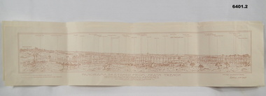
Map - Panorama sketch from Heath Trench Sector Factory Farm to Messines, 11 April 1917
Panoramic sketch by George W Bleach A 2nd Anzac Topographical Section. April 11th 1917. View from Heath Trench. Co-ords of O.P.U13.b 30.20Panoramic view of Messines. Printed on cream card. Sepia image. By George W Bleach A 2nd Anzac Topographical Section. April 11th 1917. George W Bleach A 2nd Anzac Topographical Section. April 11th 1917.panoramic view of messines -
 Bendigo Military Museum
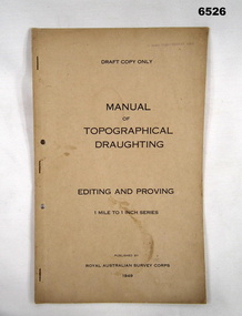
Document - Royal Australian Survey Corps - Manual of Topographical Draughting - Editing and Proving 1949, Royal Australian Survey Corps, 1949
This Draft document is part of the Topographical Drafting Manual produced by the Royal Australian Survey Corps in 1949. This document covers the guidelines for Editing and Proving (quality control) of the 1 Mile to 1 Inch map series that was widely produced by the Corps over Australia.A 10 x page foolscap sized buff coloured covered document, stapled and two hole punchedStamped on cover "E Comd Field Survey Unit"royal australian survey corps, rasvy, fortuna, army survey regiment, army svy regt, asr -
 Bendigo Military Museum
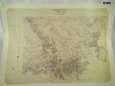
Map - Australian Topographical Survey SYDNEY / 56III Southern Half, NE Plane Table Field sheet 1915, Australian Survey Corps, 6 Dec 1915
... Plane Table Field sheet 1915 Map Australian Topographical Survey ...This is a unique example of a hand drawn plane table sheet produced in the first year of the Australian Survey Corps by original members of the Corps. Roseblade and Lynch 5 Dec 1915. Of interest is the documented times that it took to create the original field sheet. Also of interest is the fact that this field sheet that was used to create the actual SYDNEY map sheet was contoured, many map sheets produced up until now were purely planimetric and lacked contouring that was needed for military use. This is a reproduction print of a photograph of the original field sheet and was printed at the Army Survey Regiment, Bendigo.Reprinted coloured Image of Australian Topographical Survey SYDNEY /56 III Southern Half, hand drawn NE Plane Table field sheet. Includes an itemized summary of work performed by HA Roseblade CSM Australian Survey Corps 1915, Signed by J Lynch Lieutenant.royal australian survey corps, rasvy, fortuna, army survey regiment, army svy regt, asr -
 Bendigo Military Museum
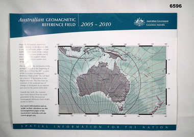
Flyer - Australian Geomagnetic Reference Field 2005-2010, Geoscience Australia, 2005
Front side shows a map of australia with red lines of Magnetic Declination and blue lines depicting contours of the projected rate of declination change 2005 - 2010. The reverse side shows a world map with lines of magnetic declination at five-degree intervals. There are also three smaller Australian maps showing contours of "Total Field", "Horizontal Field (H)" and "Vertical Field (V)." Magnetic information was used extensively on the majority of maps produced by the Royal Australian Survey Corps, both topographic and aeronautical.Single A4 size sheet printed in colour on both sidesroyal australian survey corps, rasvy, fortuna, army survey regiment, army svy regt, geoscience australia -
Stawell Historical Society Inc
Map, Stawell Gold Mine, Plan of Surface Topographical Detail, 27 March 2007
... Magdala Decline as at 27 March 2007 Plan of Surface Topographical ...Stawell Victoria Showing Magdala Decline as at 27 March 2007 Stawell Gold Mines mining, gold