Showing 182 items matching "trees of significance"
-
 Victorian Interpretive Projects Inc.
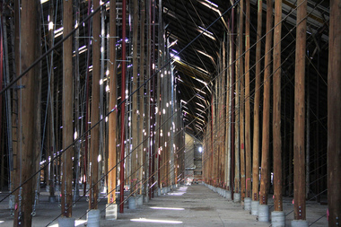
Photograph - digital, LJ Gervasoni, Murtoa Stick Shed 00031, 13/08/2011
From the Victorian Heritage Register statement of significance H0791 The Marmalake/Murtoa Grain Store, originally the No.1 Murtoa Shed, is located within the Murtoa Grain Terminal, adjacent to the grain elevator tower and railway line. The shed is 280m long, 60m wide and 19m high at the ridge with a capacity of 3.4 million bushels. The hipped corrugated iron roof of the shed is supported on approximately 600 unmilled hardwood poles set in a concrete slab floor and braced with iron tie rods. These poles are the reason for use of the term "stick shed". With its vast gabled interior and the long rows of poles the space has been likened to the nave of a cathedral. An elevator at one end took wheat from railway trucks to ridge level where it was distributed by conveyor along the length of the shed, creating a huge single mound of grain. Braced internal timber bulkheads on either side took the lateral thrust of the wheat, and conveyors at ground level outside the bulkheads took wheat back to the elevator for transport elsewhere. Wheat had been handled in jute bags from the start of the Victorian wheat industry in the mid nineteenth century. Bulk storage had been developed in North America from the early 1900s. NSW began building substantial concrete silos from 1920-21. In Western Australia, farmers' co-operatives, who had to supply their own bulk storage from 1934-5, pioneered the use of low-cost horizontal sheds of timber and corrugated iron for bulk storage. Following its establishment in 1935 the Victorian Grain Elevators Board (GEB) planned a network of 160 concrete silos in country locations, connected by rail to the shipping terminal at Geelong. By the outbreak of the Second World War there was a worldwide glut of wheat, and Australia soon had a massive surplus which it was unable to export. Only 48 silos had been established under the Victorian Silo Scheme so far, and wartime material and labour restrictions prevented progress with this scheme. The storage deficit had become an emergency by 1941 as Britain obtained its imports from North America, rather than over the lengthy and difficult shipping route from Australia. In 1941 the GEB, under chairman and general manager Harold Glowrey, proposed large temporary versions of the horizontal bulk storage sheds already in use in Western Australia. The proposal was approved by the Victorian Wheat and Woolgrowers Association, who considered the use of shed storages as a longer term proposition. After initial resistance from the Australian Wheat Board, some of whose members represented wheat bagging interests, the Commonwealth and Victorian governments agreed to split the costs, and Murtoa was chosen as a suitable site for the first emergency storage. The main contractor, Green Bros, commenced work on the No.1 Murtoa Shed in September 1941, deliveries of bulk wheat began in January 1942, and the store was full by June of the same year. In the following years the Council for Scientific and Industrial Research (later CSIRO) conducted valuable research and experiment on the impacts and control of insect pests at the Murtoa No.1 shed. With these discoveries, and the development of more effective pesticides, use of the No.1 shed and the larger No.2 shed, erected in 1942/43, continued for many years. The No.2 shed was demolished in 1975. By the 1990s, pest resistance to pesticides and requirements for both pest free and insecticide free grain rendered open storage of this type unviable. The No. 1 store was also becoming increasingly expensive to maintain, and its use was phased out from 1989.Image of the Marmalake/Murtoa Grain Store which is of historical, architectural, scientific (technical) and social significance to the State of VictoriaDigital colour image of the interior of the Marmaduke . Murtoa grain storage facility better known as the Stick Shed. The shed was constructed in World War Two to store grain. The supporting columns are trees.marmalake, murtoa grain store, wheat store, stick shed, murtoa -
 Wangaratta Historical Society
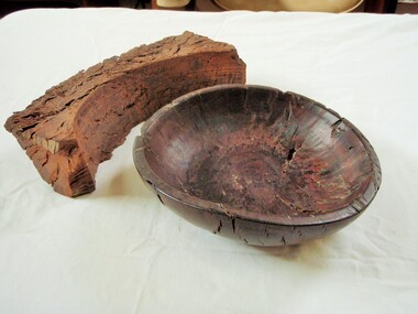
Wooden Fruit Bowl, Red Gum Bowl
This wood is made from Red River Gum tree wood, these trees live for between 500 to 1,000 years of age. The wood in this bowl has been carbon dated in the USA to be 4,500 years old.This bowl is significant because of the age of the wood it is made from. 000016 Wooden Fruit Bowl The timber this fruit bowl was made from was a red gum tree taken from the Ovens river at Tarrawingee (12 km from Wangaratta)where it had been submerged for years. It was made on a lathe by Ken Hill. The bowl warped and cracked shortly after being turned. A piece of the wood was taken to the USA by a visitor where it was carbon dated to be 4500 years old Measurements: Diameter: 22cm Height: 6cm Colour: Dark red brown Photographed beside a piece of natural red gum Tarrawingee is 12 Km North East of Wangaratta on the Great Alpine Road Significance: 4500 year old red gum wood is rare in this area. red river gum wooden bowl wangaratta historical society -
 City of Ballarat
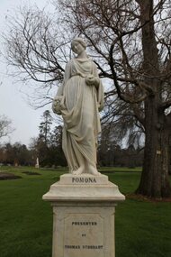
Artwork, other - Public Artwork, B. Raggi, Pomona, Circa 1880
Thomas Stoddart (1828 - 1905) bought 12 white marble statues during a visit to Italy. Stoddart arranged for them to be shipped to Victoria and placed on pedestals of Sicilian marble and on bases of Victorian granite. These statues were unveiled in the gardens on Queen Victoria's birthday, 24th May, 1884. His intention was for the statues to adorn and add interest to the gardens. The Roman Goddess of fruit trees, Pomona, is shown holding a vessel and fruit to illustrate her care and cultivation of trees and the bearing of fruitful abundance.The artwork is of historic and aesthetic significance to the people of BallaratWhite marble figure of a woman holding a vessel and fruitPomona by B. Raggipomona, stoddard, botanic gardens -
 City of Ballarat
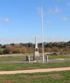
Ceremonial object - Public Artwork, F. W. Commons, Miners Rest Soldiers Memorial by F. W. Commons, 1920
Erected in the township of Miners Rest in 1920 in remembrance of fallen soldiers, this granite plinth cenotaph stands at the West end of an Avenue of Honour with 25 trees. The memorial is of Harcourt colonial granite, with bronze face plates, and contains the names of twenty-four soldiers of the district who sacrificed their lives at war. The monument was designed by the well-known sculptor, Mr F. W. Commons, and the work executed by returned soldiers employed at his studio on Creswick Road, Ballarat.The memorial is of historic and social significance to the people of BallaratGranite stone memorial including plaques on a bluestone base. 4 smaller granite posts and flag pole. In honour of our men of this district who gave their lives in the great war 1914-19. Duty Nobly Done. Erected by residents A.D.1920. Unveiled by Sir A. J. Peacock K.C.M.C., M.L.A. 23rd May 1920 Soldiers named; L.C. Blackman, D.G. Chisholm, J. Dowie, D. Dobson, H. Fisher, A.E. Gray, E.S. Holgate, H.S. Holgate, A. Kennedy, W.C. Kilfeder, G.A. Loader, H.R. Lonsdale, W. Miller, P. Morgan, C.A. Morrison, J. McDonald, N. McKenzie, L. Pollock, W.G. Pollock, A. Robertson, C.F. Shelton, P.J. Shelton, G.F. Smith, J.T. Swain.miners rest cenotaph, miners rest avenue of honour -
 City of Ballarat
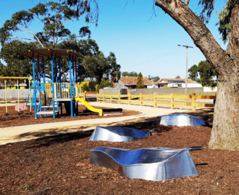
Artwork, other - Public Artwork, Col Henry, Spirit of the Forest by Col Henry, 2018
The artwork sought inspiration by the local history of Wendouree West and is a feature at the Wendouree West Recreation Reserve commissioned as part of a redevelopment of the park in 2017-2018. The artwork is located within close proximity to new playground facilities and promotes positive stories about Wendouree West to locals and the wider community.The artwork is of aesthetic significance to the people of BallaratThree stainless steel sculptures of Kurrajong tree leaves Col Henry 2018spirit of the forest, wendouree west, col henry, australian sculpture -
 City of Ballarat
Artwork, other - Public Artwork, Ratartat, Crossing Rubicon, 2008
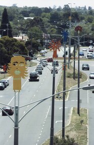
“This public art project honours the people and suburb of Sebastopol, as well as providing a strong visual identity for Albert Street. It will make the street a lot more attractive and welcoming. The project is the outcome of extensive consultation with groups and individuals in the Sebastopol community, who have made suggestions both as to the nature of the project but also the aspects of life in their community they wanted to represent through the artwork.”Crossing Rubicon by Ratartat is located in Albert Street, Sebastopol, Ballarat. A row of 16 lampposts in Sebastopol’s main street are topped with large enamelled steel sculptures of trees, representing different aspects of Sebastopol’s community life and history. Ratartat is an artistic collaboration of Ballarat-based artists Geoff Bonney and Pete Widmer. The name, Crossing Rubicon, refers to Rubicon Street, the boundary between Redan and Sebastopol. The street was named after the Rubicon River, an ancient boundary between Italy and Gaul. Julius Caesar’s decision to cross the river, thereby rebelling against the Roman Senate, gave rise to the expression “crossing the Rubicon”, meaning going past the point of no return.Sixteen powder-coated steel sculptures mounted on light polesrubicon, sebastopol, ratartat -
 Hume City Civic Collection
Photograph, early 1990s
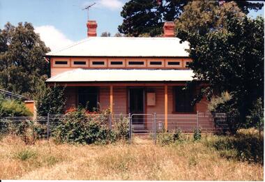
The weatherboard house is one of the six weatherboard cottages which were built on the east side of O'Shanassy Street in the early 1900s. It has been listed in the Heritage Study in 1998. Scheduled as having some significance and recommended for further investigation.A coloured photograph of a weatherboard Victorian cottage with an overhanging verandah across the double fronted building. The weatherboard walls are painted biscuit and the window and door frames are tan. A wooden tile trim painted in biscuit, tan and dark green. There are two stepped chimneys protruding from the white painted corrugated iron roof. The overgrown garden has low growing trees and shrubs.george evans collection -
 Nillumbik Shire Council
Sculpture: Tony Trembath (b.1946 Sale, Victoria), Tony Trembath, The Fences Act 1968 - Location: Edendale Farm (entrance) 30 Gastons Road, Eltham, 1989 - 1994
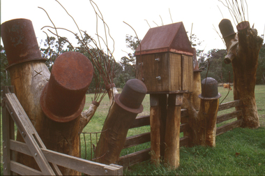
Eltham Council (now the Shire of Nillumbik) commissioned this work in 1989 to create an entrance / gateway to Edendale Community Farm. It was also aided by a grant from the Ministry of the Arts (now Arts Victoria). The former name of this work was "Gateway to Edendale Farm". Edendale Farm is a demonstration farm modelling sustainable environmental practices, providing support to the local residents of Nillumbik. Established in 1986, the land was purchased in 1970. It was previously an English gentleman's residence and was used for grazing. It consists of 5.6 hectares, with the Diamond Creek meandering through the property. The Victorian Fences Act 1968 governs liability of occupiers of adjoining lands to fence, and deals with disputes between neighbours regarding boundaries fences and costs. This work took into consideration ideas and suggestions from residents and committees, who required the use of recycled materials and that the work celebrate man's relationship with nature, animals and the earth, as well as relate to the fence-line on the far side of the carpark. Trembath also absorbed significant aspects of local history, making references to Eltham's agricultural past, the clearing of the land, the destruction of trees, the ruthless pruning of trees by suburban Councils and incorporated such Australian features as the post and rail fence. 'The Fences Act 1968' is significant for aesthetic, historic and social reasons at a regional level. It makes prominent the historical and social significance of Edendale and the rural aspects of Nillumbik. The use of existing tree stumps and salt pots in the work explores the iconography of the countryside such as the isolated farmhouse, pioneering farming practices, post and rail fencing and the regrowth of lopped trees. The title of the work, as well as the extensive community involvement in its creation, also makes reference to the Victorian Fences Act 1968, which makes neighbours jointly responsible for the cost of construction and maintenance of fences in the partitioning of land for settlement. 'The Fences Act 1968' has been classified as of regional significance by the National Trust of Australia. The work is an installation of wood and metal, approximately twenty five meters long. The design is very informal and rustic and runs the full width of the fence-line. It comprises groups of recycled tree trunks fitted with metal caps (chrome-nickel 'salt pots' that are shaped like tall bowler / top hats). Metal rods protrude from the trunks and some of these rods have metal birds. Two larger, sentinel-like stumps at the two outer ends have metal flame-like wings, which bend inward. To the left of the entrance, a simple architectural element indicates an isolated farmhouse. The rustic fence runs between the groups of tree trunks with native planting in clumps along it. The fence-line incorporates a functional engineered double gate and post and rail fencing. There may be many interpretations of the work and the intention is to stimulate interest and imagination rather than alienate. Interpretation is based on the personal experience that a visitor brings. The artist recommended that no explanation of the design logic be positioned with the work. N/Apublic art, sculpture, edendale, recycled, wood, metal, fences act 1968, gate, trembath, salt pot, tree stumps -
 Westbourne Grammar Heritage Collection
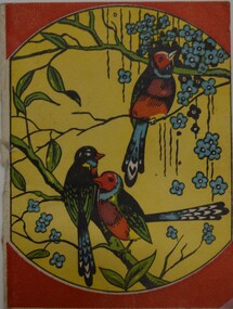
Card - Christmas Card from M.M. Molland
This card was sent to a student of the school in the 1950s. It was donated to the heritage collection along with another personal letter from Principal Molland, sent to the student when she was away from school, ill with measles. The card demonstrates the personal attention that students received from Mabel Molland and has historic significance and interpretive capacity in understanding the kind of leader and educator that Mabel Molland was. Small card with printed front, featuring a yellow circle in the centre with areas of red at the top and bottom. The image in the yellow circle consists of two birds on a lower tree branch and a further bird on an upper thin branch surrounded by blue flowers. Predominant colours are yellow, red, green and blue.Inside the card there is a message to a student. The message is signed M.M. Molland. -
 Whitehorse Historical Society Inc.
Document, Guidelines for areas of special significance, 2002
A brochure to provide guidelines for the siting of buildings, layout of gardens, and retention of trees to retain the environmental and neighbourhood characteristics of areas within the City of Whitehorse.A brochure to provide guidelines for the siting of buildings, layout of gardens, and retention of trees to retain the environmental and neighbourhood characteristics of areas within the City of Whitehorse.A brochure to provide guidelines for the siting of buildings, layout of gardens, and retention of trees to retain the environmental and neighbourhood characteristics of areas within the City of Whitehorse.city of whitehorse, gardens, environment, trees -
 Ballarat Tramway Museum
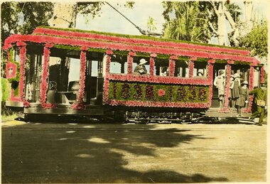
Photograph - Colour Photograph/s, State Electricity Commission of Victoria (SECV), 1938
Yields information a tram that was decorated for the 1938 centenary celebrations of the State of Victoria. Refer to pages 70 & 71 of "The Golden City and its Tramways" for these photographs and others in use and notes. The hand colour and then photographic reproduction adds to the significance of this print.Colour print of an original black and white photo print that has been hand coloured for reproduction of Ballarat (SEC 1st) No. 23, decorated for the centenary of settlement in the Ballarat district in 1938. Tram has female students on board, with conductor alighting. Shows track brakes on the tramcar. Tram has been coloured with pink and green colours, including the conductors uniform and the trees behind the tram. See also Reg Items 1021, 1361 and 1362 for other photographs of this tram, in particular 3861 which is the black and white version of this photograph and See page 70 & 71 of "The Golden City and its Tramways" for these photographs and others in use and notes. Hi Res scan added 25/3/2011.centenary, decorated trams, special trams, floral tram, tram 23 -
 Ballarat Tramway Museum
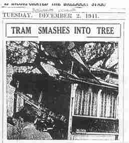
Document - Photocopy, Alan Bradley, "Tram smashes into tree", mid 1990's
... and in particular on in 1941 when a tram was derailed and hit a tree ...Yields information about tramway accidents in Drummond St Ballarat, during the SEC era and in particular on in 1941 when a tram was derailed and hit a tree resulting in substantial damage. Significance is reduced by the quality of the photocopy but gives the source details.Photocopy of a photograph that appeared in The Courier, Ballarat newspaper of 2-12-1941 of tram No. 24 that had collided with a truck at corner of Drummond Sth and Dana St the previous day. Refer to Reg Item 4045 for further details. Shows the tram in collision with the tree and boys on bicycles around tram. See Reg item 4046 for another photograph of the same accident - ex The Age newspaper. Collected by Alan Bradley from State Library - see note on Reg Item 4045.trams, tramways, accidents, collision, drummond st, dana st -
 Bendigo Historical Society Inc.
Document - WHITE HILLS BOTANIC GARDENS, BENDIGO: HERITAGE SIGNIFICANCE ASSESSMENT AND STRATEGY PROJECT
Four hundred and forty three page report titled 'White Hills Botanic Gardens, Bendigo - Heritage Significance Assessment and Strategy Project by Lee Andrews & Associates Heritage Consulting, dated 31 October 2006. Contains History of White Hills Botanic Gardens, Physical Survey ad Analysis, Comparative Analysis, Analysis and Assessment of Cultural Significance, Developing the Conservation Policy, Conservation Policy, Conservation Guidelines, Conservation Actions,References and Appendices. Also contains a number of photos, copies of plans and documents, and a plan of the area with the trees marked and identified.document, white hills botanic gardens bendigo - heritage significance assessment and strategy project, bendigo historical society, jim evans, tim buykx, greater bendigo city council, lee andrews & associates heritage consulting, bendigo advertiser, the bendigonian, bendigo independent, argus, bendigo homes and property, mal gregory, mitch kemp, anthony sheean, casey ely, vicki johnson, sandra crump, friends of bendigo's botanic gardens, jane cleary, judy milner, jan orr, heritage victoria, john hawker, department of sustainability and environment historic places, norm stimson, bill dundas, janette hodgson, royal botanic gardens melbourne, roger spencer, university of melbourne burnley campus, greg moore, goldfields research centre, bendigo library, vivien newton, rita hull, state library of victoria, matheson library monash university, mueller correspondence project, sara maroske, library of the royal botanic gardens melbourne jill thurlow, helen cohn, gwen pascoe, john dwyer, larritt and russell -
 Buninyong & District Historical Society
Photograph - Original B/W Photograph, De Soza park, Warrenheip St., Buninyong, with poppet head, rotunda and Chilean Wheel sculpture
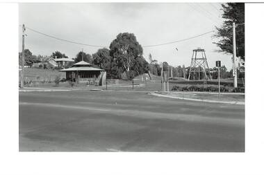
De Soza park was developed as a public amenity from the early 1980s. The poppet head and Chilean wheel sculpture are representative of the gold mining origins of the town.The park, located centrally in Buninyong is of social and historic significance.Original B/W photograph of streetscape of De Soza park frontage to Warrenheip St., Buninyong, with poppet head, rotunda and Chilean Wheel sculpture, former post office in background. Large eucalypt tree present behind rotunda, large cypress tree to north of park.buninyong, de soza, park, rotunda, poppet head, sculpture, chilean wheel, post office, warrenheip st, streetscape -
 Buninyong & District Historical Society
Photograph - Original B/W Photograph, View over the Gong towards the Buninyong Gardens, with established trees and early model motor vehicles
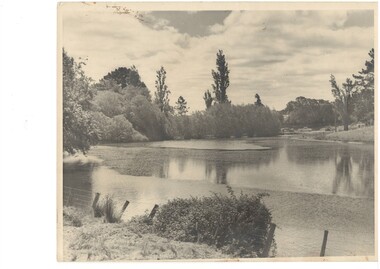
The photograph, taken c 1940 show The Gong and the view to the Buninyong Gardens. The trees in the Gardens are well established and early model motor vehicles are seen parked on the Gong dam wall. The Gong and the Buninyong Botanic Gardens are iconic features of the town. They are of great historic, aesthetic and social significance. They are representative of early parklands.Original B/W photograph of the view over the Gong towards the Buninyong Gardens, with established trees and early model motor vehiclesthe gong, buninyong, gardens, botanic gardens, cars, parklands -
 Buninyong & District Historical Society
Photograph - Original B/W photograph, Mr Clive Brooks, Streetscape of Learmonth St., Buninyong, looking over roundabout to Town Hall and businesses, 18th September 1993
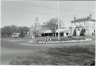
Part of a photographic record of Buninyong township. The buildings range from 1960s back to 1896, 1887, 1866, to a remnant of 1855, hidden within the shop of D. Brown electrician, consequently reflecting much alteration and change when compared to earlier photos.The streetscape is of historic significance, recording the detail of the streetscape in 1993. Many of the buildings have since undergone significant renovation/change.Streetscape of Learmonth St., Buninyong, looking over roundabout to Town Hall and businesses. Elm trees in the grounds of the Uniting (formerly Presbyterian) Church are seen in the background. Buildings are the fire station, council offices, Town Hall, Whykes Butchers, M. & D. Brown electrician, Buninyong Cake Shop and former bank, now a residence. Oak trees are in front of the council offices and shire hall. One tree planted in 1959 to mark the occasion of the connection of a water supply to Buninyong. A variety of elm is at the end of the row outside the Bank, now a residence. Junipers on each side of the former bank door was planted c1970.learmonth st, buninyong, bank, cake shop, m & d brown, electrician, whykes butchers, whykes, town hall, council offices, fire station -
 Kew Historical Society Inc
Functional object - Wrought iron nails from 'Reno', St John's Parade, c. 1864
Comparatively few weatherboard houses in Kew survived from the early years of settlement into the second half of the 20th century. One such property was ‘Reno’, which once stood on the east side of St John’s Parade. Its earliest recorded owner was the architect Samuel Cocking who lived there from c.1865 until his death in 1888. The original landholding was bordered by Cotham Road, Glenferrie Road, Wellington Street, and Charles Street. The southern portion of this land included a fine orchard, with many imported trees. The old summer house, at first in the orchard, was later removed to the house garden. The MMBW Detail Plan No.1576 (1904) shows the remaining portion of the original land holding, including a semi-circular pathway at the front, and garden features such as an aviary, a fountain and grotto, and a fernery. None of these are apparent in photographs dating from the 1960s, where the garden, which once included rare plants provided by Baron Von Mueller, surrounds the cottage in a tangled frenzy. Despite a ‘local significance’ classification by the National Trust, the house was demolished in 1977.7 square headed iron nails collected from Reno before its demolition. In envelope marked with the name Joy Stewartreno, nails, samuel cocking -
![Wallpaper from 'Reno', St John's Parade [Kew]](/media/collectors/550653872162f11fb04854aa/items/57975996d0cdd1098c81d980/item-media/579759ded0cdd1098c81f6fa/item-fit-380x285.jpg) Kew Historical Society Inc
Kew Historical Society IncDecorative object - Wallpaper sample from 'Reno', St John's Parade, 1890s
Comparatively few weatherboard houses in Kew survived from the early years of settlement into the second half of the 20th century. One such property was ‘Reno’, which once stood on the east side of St John’s Parade. Its earliest recorded owner was the architect Samuel Cocking who lived there from c.1865 until his death in 1888. The original landholding was bordered by Cotham Road, Glenferrie Road, Wellington Street, and Charles Street. The southern portion of this land included a fine orchard, with many imported trees. The old summer house, at first in the orchard, was later removed to the house garden. The MMBW Detail Plan No.1576 (1904) shows the remaining portion of the original land holding, including a semi-circular pathway at the front, and garden features such as an aviary, a fountain and grotto, and a fernery. None of these are apparent in photographs dating from the 1960s, where the garden, which once included rare plants provided by Baron Von Mueller, surrounds the cottage in a tangled frenzy. Despite a ‘local significance’ classification by the National Trust, the house was demolished in 1977. Wallpaper fragment from ‘Reno’. This small fragment of floral wall paper is a bolder design than the delicately drawn flowers in 1977.0005.1. The flowers in this example were impressionistically created using printing blocks that allowed for different thicknesses of paint to be applied in the hand-blocking process. wallpaper, reno, st john's parade, kew -
![Wallpaper from 'Reno', St John's Parade [Kew]](/media/collectors/550653872162f11fb04854aa/items/57975a62d0cdd1098c8232a8/item-media/57975cabd0cdd1098c836f91/item-fit-380x285.jpg) Kew Historical Society Inc
Kew Historical Society IncDecorative object - Wallpaper sample from 'Reno', St John's Parade, 1870s
Comparatively few weatherboard houses in Kew survived from the early years of settlement into the second half of the 20th century. One such property was ‘Reno’, which once stood on the east side of St John’s Parade. Its earliest recorded owner was the architect Samuel Cocking who lived there from c.1865 until his death in 1888. The original landholding was bordered by Cotham Road, Glenferrie Road, Wellington Street, and Charles Street. The southern portion of this land included a fine orchard, with many imported trees. The old summer house, at first in the orchard, was later removed to the house garden. The MMBW Detail Plan No.1576 (1904) shows the remaining portion of the original land holding, including a semi-circular pathway at the front, and garden features such as an aviary, a fountain and grotto, and a fernery. None of these are apparent in photographs dating from the 1960s, where the garden, which once included rare plants provided by Baron Von Mueller, surrounds the cottage in a tangled frenzy. Despite a ‘local significance’ classification by the National Trust, the house was demolished in 1977.Wallpaper fragment from ‘Reno’. This large single example is interesting as it represents a change in fashion and style from the finely drawn flowers (1971.0002.1) of an older paper, parts of which can be seen behind this sample. Typically the updating of wallpapers was accomplished by laying a new paper over the old. The ‘newer’ wallpaper is of a single colour, the tone of which may have suffered from colour distortion due to ageing. The new block-printed design, featuring repeated sprays of flowers and leaves combines a bold use of colour with an elegance of design.reno, st john's parade, kew, samuel cocking, wallpaper -
![Wallpaper fragment - Reno, St John's Parade [Kew]](/media/collectors/550653872162f11fb04854aa/items/57975cd6d0cdd1098c838ddb/item-media/57975d42d0cdd1098c83c222/item-fit-380x285.jpg) Kew Historical Society Inc
Kew Historical Society IncDecorative object - Wallpaper sample from 'Reno', St John's Parade, 1870s
Comparatively few weatherboard houses in Kew survived from the early years of settlement into the second half of the 20th century. One such property was ‘Reno’, which once stood on the east side of St John’s Parade. Its earliest recorded owner was the architect Samuel Cocking who lived there from c.1865 until his death in 1888. The original landholding was bordered by Cotham Road, Glenferrie Road, Wellington Street, and Charles Street. The southern portion of this land included a fine orchard, with many imported trees. The old summer house, at first in the orchard, was later removed to the house garden. The MMBW Detail Plan No.1576 (1904) shows the remaining portion of the original land holding, including a semi-circular pathway at the front, and garden features such as an aviary, a fountain and grotto, and a fernery. None of these are apparent in photographs dating from the 1960s, where the garden, which once included rare plants provided by Baron Von Mueller, surrounds the cottage in a tangled frenzy. Despite a ‘local significance’ classification by the National Trust, the house was demolished in 1977. Wallpaper fragment from ‘Reno’. These three boldly designed samples from a single room are in shades of green and brown, highlighted by yellow and red floral sprays. While more accurately printed and coloured, the fragment lacks the freedom of design of the earlier samples.wallpaper, reno, st john's parade, kew, samuel cocking -
![Reno, St John's Parade [Kew] - Reno, St John's Parade [Kew]](/media/collectors/550653872162f11fb04854aa/items/57975dcbd0cdd1098c840aaf/item-media/57975e31d0cdd1098c84343d/item-fit-380x285.jpg) Kew Historical Society Inc
Kew Historical Society IncDecorative object - Wallpaper samples from 'Reno', St John's Parade, 1880-1910
Comparatively few weatherboard houses in Kew survived from the early years of settlement into the second half of the 20th century. One such property was ‘Reno’, which once stood on the east side of St John’s Parade. Its earliest recorded owner was the architect Samuel Cocking who lived there from c.1865 until his death in 1888. The original landholding was bordered by Cotham Road, Glenferrie Road, Wellington Street, and Charles Street. The southern portion of this land included a fine orchard, with many imported trees. The old summer house, at first in the orchard, was later removed to the house garden. The MMBW Detail Plan No.1576 (1904) shows the remaining portion of the original land holding, including a semi-circular pathway at the front, and garden features such as an aviary, a fountain and grotto, and a fernery. None of these are apparent in photographs dating from the 1960s, where the garden, which once included rare plants provided by Baron Von Mueller, surrounds the cottage in a tangled frenzy. Despite a ‘local significance’ classification by the National Trust, the house was demolished in 1977.Wallpaper fragment from ‘Reno’. These two large fragments of wallpaper have a formality of design that is accentuated by the wide borders and narrow vertical lines that separate the repeated designs of rose garlands in vases on a vertical trellis design. The design is in tones of pink and green with gilding.reno, st john's parade, kew, samuel cocking, wallpaper -
![Wallpaper from 'Reno', St John's Parade [Kew]](/media/collectors/550653872162f11fb04854aa/items/57975eabd0cdd1098c846619/item-media/57975ee7d0cdd1098c8484f7/item-fit-380x285.jpg) Kew Historical Society Inc
Kew Historical Society IncDecorative object - Wallpaper samples from 'Reno', St John's Parade, 1880-1914
Comparatively few weatherboard houses in Kew survived from the early years of settlement into the second half of the 20th century. One such property was ‘Reno’, which once stood on the east side of St John’s Parade. Its earliest recorded owner was the architect Samuel Cocking who lived there from c.1865 until his death in 1888. The original landholding was bordered by Cotham Road, Glenferrie Road, Wellington Street, and Charles Street. The southern portion of this land included a fine orchard, with many imported trees. The old summer house, at first in the orchard, was later removed to the house garden. The MMBW Detail Plan No.1576 (1904) shows the remaining portion of the original land holding, including a semi-circular pathway at the front, and garden features such as an aviary, a fountain and grotto, and a fernery. None of these are apparent in photographs dating from the 1960s, where the garden, which once included rare plants provided by Baron Von Mueller, surrounds the cottage in a tangled frenzy. Despite a ‘local significance’ classification by the National Trust, the house was demolished in 1977. Wallpaper fragment from ‘Reno’. This small fragment is part of the larger design shown in the previous sample (1971.0002.5). It includes a detail of the trellis element from the larger scheme.wallpaper, samuel cocking, reno, st john's parade, kew -
![Letter Plate, 'Reno', St John's Parade [Kew]](/media/collectors/550653872162f11fb04854aa/items/57a03863d0cdd1210435bac1/item-media/57a038b1d0cdd1210435f155/item-fit-380x285.jpg) Kew Historical Society Inc
Kew Historical Society IncFunctional object - Letter Plate, 'Reno', St John's Parade, c.1900
Comparatively few weatherboard houses in Kew survived from the early years of settlement into the second half of the 20th century. One such property was ‘Reno’, which once stood on the east side of St John’s Parade. Its earliest recorded owner was the architect Samuel Cocking who lived there from c.1865 until his death in 1888. The original landholding was bordered by Cotham Road, Glenferrie Road, Wellington Street, and Charles Street. The southern portion of this land included a fine orchard, with many imported trees. The old summer house, at first in the orchard, was later removed to the house garden. The MMBW Detail Plan No.1576 (1904) shows the remaining portion of the original land holding, including a semi-circular pathway at the front, and garden features such as an aviary, a fountain and grotto, and a fernery. None of these are apparent in photographs dating from the 1960s, where the garden, which once included rare plants provided by Baron Von Mueller, surrounds the cottage in a tangled frenzy. Despite a ‘local significance’ classification by the National Trust, the house was demolished in 1977.Brass letter plate, originally from the front door of Reno in St John's Parade, Kew. Donated by Miss McDowell in 1977, in the year the house was demolished.reno, st john's parade, kew -
![Wallpaper sample from 'Reno', St John's Parade [Kew]](/media/collectors/550653872162f11fb04854aa/items/5670dfde2162f10b54fac48a/item-media/5797600bd0cdd1098c854c29/item-fit-380x285.jpg) Kew Historical Society Inc
Kew Historical Society IncDecorative object - Wallpaper sample from 'Reno', St John's Parade, 1850-1880
Comparatively few weatherboard houses in Kew survived from the early years of settlement into the second half of the 20th century. One such property was ‘Reno’, which once stood on the east side of St John’s Parade. Its earliest recorded owner was the architect Samuel Cocking who lived there from c.1865 until his death in 1888. The original landholding was bordered by Cotham Road, Glenferrie Road, Wellington Street, and Charles Street. The southern portion of this land included a fine orchard, with many imported trees. The old summer house, at first in the orchard, was later removed to the house garden. The MMBW Detail Plan No.1576 (1904) shows the remaining portion of the original land holding, including a semi-circular pathway at the front, and garden features such as an aviary, a fountain and grotto, and a fernery. None of these are apparent in photographs dating from the 1960s, where the garden, which once included rare plants provided by Baron Von Mueller, surrounds the cottage in a tangled frenzy. Despite a ‘local significance’ classification by the National Trust, the house was demolished in 1977.Original sample of nineteenth century wallpaper from one of the earliest homes in Kew (Victoria).Wallpaper fragment from ‘Reno’. These two samples of light brown Victorian-period wallpaper were overprinted with flowers and leaves that are outlined in maroon. Flowers and foliage are painted in blue of varying intensity, giving the impression of being hand painted. The style of this wallpaper would have been suited to a bedroom or drawing room.wallpaper, samuel cocking, reno, st john's parade, kew -
 Kew Historical Society Inc
Slide - 'Reno', St John 's Parade, 1977
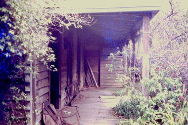
‘Reno’, stood on the east side of St John’s Parade. Its earliest recorded owner was the architect Samuel Cocking who lived there from c.1865 until his death in 1888. The original landholding was bordered by Cotham Road, Glenferrie Road, Wellington Street, and Charles Street. The southern portion of this land included a fine orchard, with many imported trees. The old summer house, at first in the orchard, was later removed to the house garden. The MMBW Detail Plan No.1576 (1904) shows the remaining portion of the original land holding, including a semi-circular pathway at the front, and garden features such as an aviary, a fountain and grotto, and a fernery. The garden including rare plants supplied by Baron Von Mueller, surrounds the cottage in a tangled frenzy. Despite a ‘local significance’ classification by the National Trust, the house was demolished in 1977.Rare photograph of an historically important weatherboard cottage in St John's Parade.Colour positive transparency (slide) of the verandah of 'Reno' in St John's Parade, Kew (demolished 1977). historic houses -- kew (vic.), reno -- st john's parade -- kew (vic.) -
 Kew Historical Society Inc
Slide - 'Reno', St John 's Parade, 1977
‘Reno’, stood on the east side of St John’s Parade. Its earliest recorded owner was the architect Samuel Cocking who lived there from c.1865 until his death in 1888. The original landholding was bordered by Cotham Road, Glenferrie Road, Wellington Street, and Charles Street. The southern portion of this land included a fine orchard, with many imported trees. The old summer house, at first in the orchard, was later removed to the house garden. The MMBW Detail Plan No.1576 (1904) shows the remaining portion of the original land holding, including a semi-circular pathway at the front, and garden features such as an aviary, a fountain and grotto, and a fernery. The garden including rare plants supplied by Baron Von Mueller, surrounds the cottage in a tangled frenzy. Despite a ‘local significance’ classification by the National Trust, the house was demolished in 1977.Rare photograph of an historically important weatherboard cottage in St John's Parade.Colour positive transparency (slide) of the a doorway of 'Reno' in St John's Parade, Kew (demolished 1977). historic houses -- kew (vic.), reno -- st john's parade -- kew (vic.) -
 Kew Historical Society Inc
Slide - 'Reno', St John 's Parade, 1977
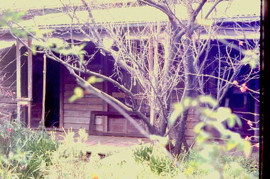
‘Reno’, stood on the east side of St John’s Parade. Its earliest recorded owner was the architect Samuel Cocking who lived there from c.1865 until his death in 1888. The original landholding was bordered by Cotham Road, Glenferrie Road, Wellington Street, and Charles Street. The southern portion of this land included a fine orchard, with many imported trees. The old summer house, at first in the orchard, was later removed to the house garden. The MMBW Detail Plan No.1576 (1904) shows the remaining portion of the original land holding, including a semi-circular pathway at the front, and garden features such as an aviary, a fountain and grotto, and a fernery. The garden including rare plants supplied by Baron Von Mueller, surrounds the cottage in a tangled frenzy. Despite a ‘local significance’ classification by the National Trust, the house was demolished in 1977.Rare photograph of an historically important weatherboard cottage in St John's Parade.Colour positive transparency (slide) of the verandah of 'Reno' in St John's Parade, Kew (demolished 1977). historic houses -- kew (vic.), reno -- st john's parade -- kew (vic.) -
 Kew Historical Society Inc
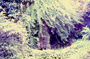
Slide - Grotto of 'Reno', St John 's Parade, 1977
‘Reno’, stood on the east side of St John’s Parade. Its earliest recorded owner was the architect Samuel Cocking who lived there from c.1865 until his death in 1888. The original landholding was bordered by Cotham Road, Glenferrie Road, Wellington Street, and Charles Street. The southern portion of this land included a fine orchard, with many imported trees. The old summer house, at first in the orchard, was later removed to the house garden. The MMBW Detail Plan No.1576 (1904) shows the remaining portion of the original land holding, including a semi-circular pathway at the front, and garden features such as an aviary, a fountain and grotto, and a fernery. The garden including rare plants supplied by Baron Von Mueller, surrounds the cottage in a tangled frenzy. Despite a ‘local significance’ classification by the National Trust, the house was demolished in 1977.Rare photograph of an historically important weatherboard cottage in St John's Parade.Colour positive transparency (slide) of the grotto in the garden of 'Reno' in St John's Parade, Kew (demolished 1977). historic houses -- kew (vic.), reno -- st john's parade -- kew (vic.) -
 Kew Historical Society Inc
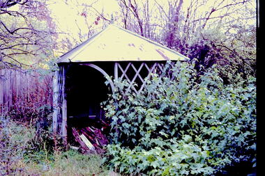
Slide - Former Summerhouse in the Garden of 'Reno', St John 's Parade, 1977
‘Reno’, stood on the east side of St John’s Parade. Its earliest recorded owner was the architect Samuel Cocking who lived there from c.1865 until his death in 1888. The original landholding was bordered by Cotham Road, Glenferrie Road, Wellington Street, and Charles Street. The southern portion of this land included a fine orchard, with many imported trees. The old summer house, at first in the orchard, was later removed to the house garden. The MMBW Detail Plan No.1576 (1904) shows the remaining portion of the original land holding, including a semi-circular pathway at the front, and garden features such as an aviary, a fountain and grotto, and a fernery. The garden including rare plants supplied by Baron Von Mueller, surrounds the cottage in a tangled frenzy. Despite a ‘local significance’ classification by the National Trust, the house was demolished in 1977.Rare photograph of an historically important weatherboard cottage in St John's Parade.Colour positive transparency (slide) of the former summerhouse in the garden of 'Reno' in St John's Parade, Kew (demolished 1977). historic houses -- kew (vic.), reno -- st john's parade -- kew (vic.) -
 Kew Historical Society Inc
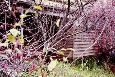
Slide - 'Reno', St John 's Parade, 1977
‘Reno’, stood on the east side of St John’s Parade. Its earliest recorded owner was the architect Samuel Cocking who lived there from c.1865 until his death in 1888. The original landholding was bordered by Cotham Road, Glenferrie Road, Wellington Street, and Charles Street. The southern portion of this land included a fine orchard, with many imported trees. The old summer house, at first in the orchard, was later removed to the house garden. The MMBW Detail Plan No.1576 (1904) shows the remaining portion of the original land holding, including a semi-circular pathway at the front, and garden features such as an aviary, a fountain and grotto, and a fernery. The garden including rare plants supplied by Baron Von Mueller, surrounds the cottage in a tangled frenzy. Despite a ‘local significance’ classification by the National Trust, the house was demolished in 1977.Rare photograph of an historically important weatherboard cottage in St John's Parade.Colour positive transparency (slide) of the garden of 'Reno' in St John's Parade, Kew (demolished 1977). historic houses -- kew (vic.), reno -- st john's parade -- kew (vic.)