Showing 110502 items matching " roads"
-
 Eltham District Historical Society Inc
Slide, Belmont Crescent, Montmorency, c. Mar. 1981
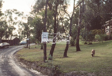
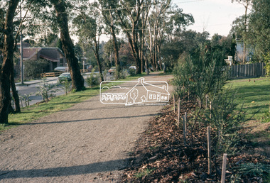
... roads ...One of a series of images of road infrastructure focussed on Belmont Crescent in Montmorency taken by Eltham Shire Council Planning and Engineering officers. They provide perspective of the changes in housing styles and road development that began sweeping in from the mid 1970s with increasing urbanisation of what was once more outlying suburbs and regions. All images have been identified with GPS35 mm colour positive transparency (1 of 8) Mount - Kodak Kodachrome CardProcessed Mar 1981infrastructure, montmorency, roads, belmont crescent -
 Clunes Museum
photograph, KODAK
VIEW OF GRAVEL ROAD FROM CLUNES TOWNSHIP TO STATION FLAT. LOWER PART OF PORT PHILLIP MINE ON LEFT OF PHOTO.VIEW OF ROAD LEADING TO STATION FLAT, CLUNES - ANGLICAN CHURCH ON HILL IN BACKGROUNDlocal history, clunes landscape. -
 Melbourne Tram Museum
Slide, John Webster, 9/03/1960 12:00:00 AM
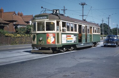
Colour slide, Kodak, white cardboard of Tram 823, in Riversdale Road, Hawthorn with the destination of Burwood Route 74. Tram has adverts for Chateau Taundra Brandy and ? Slide dated 9-3-1960.Hand writing on rear in ink "9-3-60- Track - Tram 823 Riversdale Road Melbourne"trams, tramways, riversdale rd, burwood, route 74, w5 class, tram 823 -
 Greensborough Historical Society
Photograph - Photograph (Framed), Greensborough from Diamond Creek Road
Greensborough from Diamond Creek Road, includes a view of lower Main Street and lower parkFrom the John Mackey collection. this item was displayed at the offices of Ryan, Mackey and Kelly, solicitors, Main Street Greensborough.Timber-framed photograph of view of Greensborough from Diamond Creek Road, black and white.greensborough, john mackey, blue stone bridge, marble hall -
 Whitehorse Historical Society Inc.
Article, 5 Longland Road, Heatherdale, 1984
Auction Notices of 100 year old Home,Auction Notices of 100 year old Home, 5 Longland Road, Heatherdale, on 10th March 1984.Auction Notices of 100 year old Home, longland road, heatherdale, no. 5 -
 Hume City Civic Collection
Photograph, c1960s
The photograph overlooks former railway land along Vineyard Road which is now a commercial and light industrial estate. It was taken before curbing and footpaths were laid and Vineyard Road was narrow strip of asphalt with the sides of the road unmade.A black and white photograph of Vineyard Road with the Sunbury Railway line visible across the middle distance and the former Sunbury Asylum site in the background.vineyard road, sunbury asylum, sunbury railway line, george evans collection -
 Lorne Historical Society
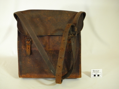
Functional object - Bag, circa1925
One of the toll bags used to collect tolls on the Great Ocean Road. First "Toll Gate" at Sunnymeade Estate as the road went through land owned by Mr C J Lane. Toll gates followed at "Stradbroke Point",later changed to "Stradbroke Knoll" named after the Govenor of Victoria, Lord Stradbroke, Grassy Creek and "The Springs". Mr W D McKay first toll keeper, then Mr & Mrs Wright. Toll commenced circa 1925 and ended 2nd October 1936. Cars were charged at 2/6 for car and driver and 1/- for each passenger. Motor cycles 2/-. Brown leather bag, with adjustable shoulder strap for carrying. Enclosed with a flap done up by 2 buckles.Hand scratched on front of bag:-"GREAT OCEAN ROAD TRUST".leather bag, toll gates, toll keepers, great ocen road -
 Glen Eira Historical Society
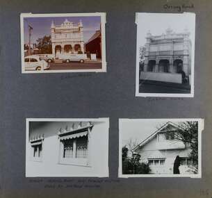
Album - Album page, Orrong Road, Circa 1972
This photograph is part of the Caulfield Historical Album 1972. This album was created in approximately 1972 as part of a project by the Caulfield Historical Society to assist in identifying buildings worthy of preservation. The album is related to a Survey the Caulfield Historical Society developed in collaboration with the National Trust of Australia (Victoria) and Caulfield City Council to identify historic buildings within the City of Caulfield that warranted the protection of a National Trust Classification. Principal photographer thought to be Trevor Hart, member of Caulfield Historical Society. Most photographs were taken between 1966-1972 with a small number of photographs being older and from unknown sources. All photographs are black and white except where stated, with 386 photographs over 198 pages.Victorian Heritage Database https://vhd.heritagecouncil.vic.gov.au/places/35576 No. 70 Orrong Road is important as an exceptionally ornate Boom style villa residence in the terraced form and in this respect is rare in Caulfield. Its architectural value is enhanced by its intact state and by the manner in which its bold architectural expression is carried through into the hallway and staircase. Victorian Heritage Database - National Trust local significance 284 Orrong Road Caulfield https://vhd.heritagecouncil.vic.gov.au/places/65700 A house designed by Harold Desbrowe Annear in 1917 and believed to have been the first "all electric" house in Melbourne. It has been extensively altered.Page 164 - four photographs of 2 different houses on Orrong Road. The top left photo is in colour while the others are in black and white.Handwritten: Orrong Road [top right] / Lisborn House [ (ed. correct name is LISBON HOUSE), under top left photo] / Lisborn House [under top right photo] / [under bottom right photo] / CORNER ORRONG ROAD AND PEARSON AVENUE / HOUSE BY DESBROWE ANNEAR [under bottom left photo] / 164 [bottom right]trevor hart, orrong road, lisbon house, lisborn house, elsternwick, pearson grove, st kilda east, caulfield north, terrace houses, cast iron work, verandahs, balconies, parapets, arches, cars, streetscapes, attic houses, desbrowe annear -
Whitehorse Historical Society Inc.
Pamphlet, Eastern freeway extension, 1/02/2000 12:00:00 AM
Eastern Freeway extension Between Springvale Road and Ringwood: flora and fauna assessment.Eastern Freeway extension Between Springvale Road and Ringwood: flora and fauna assessment. Supplement no 13 : mapping of trees and native vegetation within the Deep Creek Road realignment [by] Botanicus Australia Pty Ltd for VicRoads.Eastern Freeway extension Between Springvale Road and Ringwood: flora and fauna assessment. eastern freeway extension, native plants, wild life, vicroads, deep creek road, mitcham -
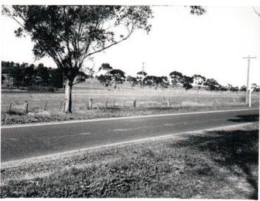
 Eltham District Historical Society Inc
Slide, Old Eltham Road, Lower Plenty, Jun. 1981
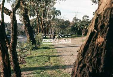
... roads ...Roll of film taken by Eltham Shire Council officers specifically focussed on road infrastructure and maintenance. Many roads of the shire were only relatively recently sealed towards the late 1980s/early 1990s.35 mm colour positive transparency (1 of 8) Mount - Kodak Kodachrome CardProcessed July 1981infrastructure, roads, lower plenty, old eltham road, road sealing -
 Eltham District Historical Society Inc
Slide, Old Eltham Road, Lower Plenty, c. Jan 1983
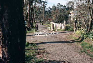
... roads ...Roll of film taken by Eltham Shire Council officers specifically focussed on road infrastructure and maintenance. Many roads of the shire were only relatively recently sealed towards the late 1980s/early 1990s.35 mm colour positive transparency (1 of 8) Mount - Kodak Kodachrome CardProcessed July 1981infrastructure, roads, lower plenty, old eltham road, road sealing -
 Eltham District Historical Society Inc
Slide, Main Road, Eltham, c. Jun 1981
... roads ...Roll of film taken by Eltham Shire Council officers specifically focussed on road infrastructure and maintenance. Many roads of the shire were only relatively recently sealed towards the late 1980s/early 1990s.35 mm colour positive transparency (1 of 8) Mount - Kodak Kodachrome CardProcessed July 1981infrastructure, roads, main road, eltham, footpaths and gutters -
 Phillip Island and District Historical Society Inc.
Photograph, 1978/79
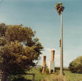
Photograph of two chimneys of George Dorward's home on the hill of Newhaven-Rhyll Road. A very tall standing Palm tree, two bushes part of a fence and in background glimpse of Westernport Bay.Remains of the home of George Dorward on the hill on Newhaven-Rhyll Road.local history, photographs, historic, buildings - historical, coloured photograph, john cook, phillip island, george dorward -
 City of Kingston
Photograph - Black and white, c. 1960
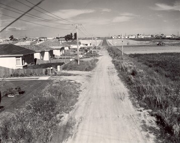
This image depicts a scene of East Bentleigh in 1960, viewed along Thomasina Street as it crosses Gladwyn Street towards East Boundary Road in the distance. The gardens and new homes are well-tended, but the street surfacing is unsealed.Developing urban area now located within the City of Glen Eira, formally City of Moorabbin. This image illustrates the mid century urban sprawl of new suburbs and the subdivision of market gardens within the municipality and the changing demographic of the district as new houses are constructed and infrastructure established. Black and white photograph of unsealed road in new development in the area of Moorabbin, new houses appear on the lefthand side with paddocks on right side of image with installation of electric poles. Sealed road in the distance. Thomasina Street, as it crosses Gladwyn Street, East Bentleigh towards East Boundary Road. Handwritten in blue ink: 60 - 373 D Handwritten in red ink: 80% Handwritten in black ink: Ch. 6bentleigh, east bentleigh, market garden, housing, suburbs, infrastructure, moorabbin -
 Melbourne Tram Museum
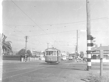
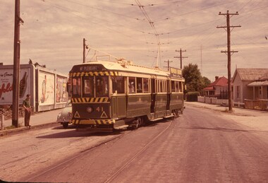
Photograph - Tram 678 crossing Geelong Road Footscray, Jim Seletto, c1960
The photograph shows an X2 class No. 678, north bound in Droop St Footscray, crossing Geelong Road with the destination of Ballarat Rd. Another tram can be seen southbound. Note the street fire alarm pillar on the right side of the photograph.Yields information about the trams in Droop St Footscray, c1960.Black and White photograph with photographer's notes on rear"678 Crossing Geelong Road" and "J Seletto photo" in ink.trams, footscray, x2 class, tram 678, droop st, geelong road -
 Kew Historical Society Inc
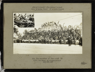
Photograph, The Sears Studio, Centenary Celebrations : Kew "Strong Post" St Kilda Road, 1934
Cr. W.D. Vaughan in 'Kew's Civic History' (1960) records that: "In connection with the Melbourne Centenary Celebrations in 1934, the Kew Council decided to organise a strong post as an appropriate gesture of welcome to H.R.H. the Duke of Gloucester. Also that the municipality be represented by a symbolic floral float in the Royal pageant. This was a striking entry and won first prize, and evoked much comment on account of its originality and truly Australian motif." The photograph of the Kew Strong Post was once part of the Municipal Collection of the former City of Kew and was presented to the Kew Historical Society before the move from the Walpole Street (Kew) Town Hall to new Civic offices in Charles Street in 1971.Historic photograph of participation by the City of Kew in celebrations for a royal visitFramed and glazed photograph on its original inscribed mount and original frame of the Kew "Strong Post" in St Kilda Road on the occasion of the visit to Melbourne of the Duke of Gloucester. The photograph has two components, at the upper left is a photo of the royal carriage while the man photo shows the people of Kew on a decorated 'Strong Post' on St Kilda Road, along which the procession progressed. T"Centenary Celebrations / Kew "Strong Post" St Kilda Road / On the occasion of the visit of / H.R.H. The Duke of Gloucester / October 18th 1934."royal visits - melboure - 1934, duke of gloucester, kew (vic.) — municipal collection -
Whitehorse Historical Society Inc.
Document, Electing members of the District Road Board, 1862
Copy from Ivan Southall''s 'A Tale of Box Hill', public meeting for the election of members of the Nunawading District Road Board, for fixing the rate for the current year and appointing auditors.Copy from Ivan Southall''s 'A Tale of Box Hill', public meeting for the election of members of the Nunawading District Road Board, for fixing the rate for the current year and appointing auditors. Extract from Road Board minute book, 10 Sept 1862.Copy from Ivan Southall''s 'A Tale of Box Hill', public meeting for the election of members of the Nunawading District Road Board, for fixing the rate for the current year and appointing auditors.local government, nunawading district roads board -
 Whitehorse Historical Society Inc.
Photograph, Railway Station from Car Park, 1/06/2009
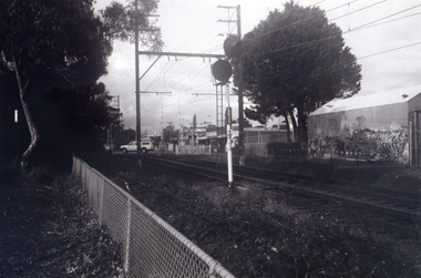
One of a collection of photographs taken of the Nunawading Railway Station prior to the lowering of the railway line and building of the new railway station on the western side of Springvale Road so that the Springvale Road Rail Crossing can be eliminated.Black & white photograph of the precinct surrounding the Nunawading Station and the Springvale Road Railway crossing. This photograph is of the station taken from the car park on west side of Springvale Road, north of railway line behind Recreation Centre. See NP 3545 to NP3567 for the complete set of photographsnunawading railway station, springvale road nunawading, redevelopment of railway line/springvale road, nunawading recreation centre -
 Orbost & District Historical Society
black and white photograph, late 19th - early 20th century
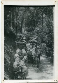
This is a photograph of bullock teams on the Cann Road. out of Cann River, East Gippsland.This is a pictorial record of transport in the mid 18th - early 19th century. Bullock teams could travel in country inaccessible to larger horse - drawn carts or wagon.A black / white photograph of two bullock teams travelling side by side along a bush road.transport-bullocks cann-river -
 Whitehorse Historical Society Inc.
Document, Auction Notice
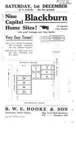
Auction notice for 9 home sitesAuction notice for 9 home sites in Molleton Street, Baldwin Road and Main Street, BlackburnAuction notice for 9 home sitesauction notice for molleton street, baldwin road, blackburn -
Whitehorse Historical Society Inc.
Document, Certificate of Title - Frederick Charles Phillips, 1909, 1934
Certificate of Title.Certificate of Title for Lot 19, Springvale Road, Tunstall and correspondence re outstanding rates on the propertyCertificate of Title.shire of blackburn and mitcham, rates, land titles, phillips, frederick charles, springvale road, nunawading -
 Ringwood and District Historical Society
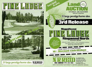
Flyer, Land Auction Sale Brochure, Pine Lodge, Ringwood North, Victoria - 3rd Release 1978
Refer also to Reg. No. 5171 for Pine Lodge Land Auction previous release, 1977.Green tri-fold advertisement for auction of home sites, with map of subdivision, photographs, and summary of local features and services for Pine Lodge, Kalinda Road, Ringwood North - 3rd release - Auction date, Saturday, 18th November, 1978, at 2:30pm.Subdivision plan includes Mundara Drive, Bidston Court, Parkgate Drive, Frodsham Road, and Bebington Close. (Agent) N.R. Reid & Co. Pty. Ltd., 10A Hewish Road, Croydon (Phone) 725 0999, 450 Little Collins Street, Melbourne (Phone) 67 1746, and 207 Stud Road, Wantirna South (Phone) 221 2222. -
Canterbury History Group
Photograph - Old Timber House in Maling Road, Jan Pigot, 1992
Part of a set of 8 coloured photographs taken by Jan Pigot to record the demolition of some buildings in Maling Road to make way for new shops and car park.Old timber house on corner of Scott Street and Maling Road 1992. canterbury, maling road, timber house, scott street, shopping centres -
 Ballarat Tramway Museum
Slide - 35mm slide/s, Wal Jack, 4/11/1961 12:00:00 AM
Photo of Ballarat No. 41, derailed in Barkly St. Ballarat near main road on 4-11-1961. Image is going red. Tram fitted with dash canopy lights, small white stripe, large triangles. Penfold Sherry ad on roof. Numerous markings on road surface of previous? derailments. Note advertisement hoardings in background of photo, one featuring an ad for Penfolds. Tram has a destination of 'Mt. Pleasant.''SEC Ballarat No. 41 derailed in Barkly St. near Main Road, 4-11-61 1.40pm' in blue ink.tramways, trams, barkly st., derailments, accidents, mt. pleasant, tram 41 -
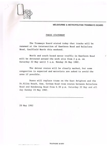 Melbourne Tram Museum
Document - Press Release, Melbourne & Metropolitan Tramways Board (MMTB), "Press Statement", Jun. 1982
Set of four MMTB Press Statements or Press Releases with MMTB letterhead. Photocopied onto A4 paper. 1. Renewal of tracks - Caulfield North - 20/5/1982. 2. Maintenance of railway crossing - Riversdale Road - 15/6/1982. 3. Maintenance of Bridge Rd and Church St Richmond - 1/6/1982 4. Maintenance work in Pascoe Vale Road, Moonee Ponds - 16/6/1982Item 4 has a handwritten note in ink "NB now half a "Grand Union" at Sydney Road & Moreland Rd"trams, tramways, mmtb, trackwork, road works, news broadcasts -
Whitehorse Historical Society Inc.
Article, Blackburn Level Crossing
Blackburn Road level Crossing was closed for 2 weeks.Blackburn Road level Crossing was closed for 2 weeks for the rail line to be lowered under Blackburn Road. More than 1,000 piles will be drilled to reinforce the rail corridor which is due to be completed 2017.Blackburn Road level Crossing was closed for 2 weeks. level crossing removal authority, blackburn road, blackburn railway crossing, blackburn railway station -
Whitehorse Historical Society Inc.
Document, City of Nunawading Heritage Survey Project, 1/10/1994 12:00:00 AM
Database of places recognised in the field survey.Database of places recognised in the field survey. List of buildings, roads etc with indexes by value and by street name.Database of places recognised in the field survey. city of nunawading heritage survey, street name -
 Eltham District Historical Society Inc
Photograph, Vacant Lot, 57 Park Road, Eltham, Dec. 1980
... roads ...Roll of film taken by Eltham Shire Council officers of roads and houses in the Eltham East area in December 1980. They provide perspective of the changes in housing styles and road development that began sweeping in from the mid 1970s with increasing urbanisation of what was once more outlying suburbs and regions. Typically part of the Beard street group, a private street scheme that developed the road infrastructure commencing in February 1982.35mm colour positive transparency Mount - Kodak Kodachrome Cardeltham, housing estate, infrastructure, park road, roads