Showing 32121 items matching "buildings."
-
 Port Melbourne Historical & Preservation Society
Flyer - Promotional material from Mission Arts Centre, 1987 - 1988
The Missions to Seamen building, designed by architect Harry Norris and built in 1937, was located on the site proposed 50 years later for development by the Sandridge Development Company. The building fell into disrepair after it was closed by the church in 1972, but enjoyed a brief and energetic period in 1987-90 when it was used as a community arts centre. These documents record the campaign waged to save the building from demolition. It was demolished in October 1995.Material relating to a campaign to save the Missions to Seamen building, 1987-88: flyers, campaign and promotional material from the Mission Arts Centremission to seamen, arts and entertainment, mission arts centre, national trust of victoria, harry a norris, pat grainger, barry merat, brian couldrey -
 Wodonga & District Historical Society Inc
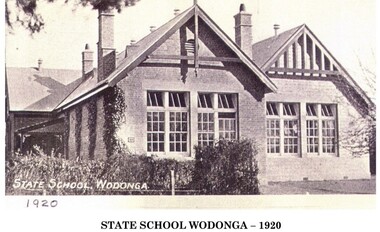
Photograph - First State School in Wodonga, 1920
Wodonga township’s first school was conducted in a small rented wooden cottage from September 1857. It was called the Belvoir National School. The building of a new schoolhouse, No. 378, began in October the same year near the corner of High and South Streets. In 1872 it changed to No. 37 Wodonga. The name was changed to Wodonga State School in 1875. This name remained until which remained until 1938 when it became a Higher Elementary School. In 1951 the Victorian Education Department purchased 12 acres of land in Ariel Street for the purpose of re-siting the State School. At this stage there were 600 pupils attending the school of which 170 were in the secondary section. Initially the Infant department moved into pre-fabricated classroom on the new site and by 1954 the whole primary school had been transferred.. The building was used became the temporary home of the Wodonga High School and later the Wodonga Technical School until they moved to new premisesA black and white image of school building mounted on card.At bottom of image: "WODONGA STATE SCHOOL 1920"wodonga state school, education wodonga -
 Port Fairy Historical Society Museum and Archives
Photograph
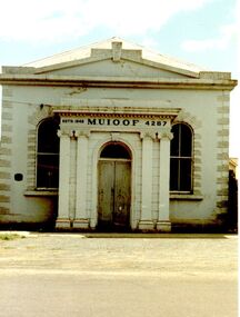
This building is the second of the Manchester Unity Independent Order of Oddfellows rooms the first built in 1862 and opened in that year on the fifteenth anniversary of the foundation of the Lodge in Belfast/Port Fairy. In 1872 a 35foot addition was added to the back and in 1873 the grand porch was added. The hall was destroyed by fire in 1875 and the only item saved was the cedar Dispensation frame of the past Grand Masters made by John Gallin that now resides in the Historical Society Rooms. The Trustees bought another building which occupied the land now occupied by the National Australia Bank on the corner of Sackville and Cox Streets but it was not suitable so they decided to re-instate the building whose ruins in the meantime had been used by Cobb and Co. This new building was designed by Charles Neylon an architect and built by Robert Ireland. The completed building was re-opened in December 1888 with four front rooms, a mezzanine floor and a hall measuring 32' by 26' and capable of holding 200. The Trustees of the Loyal Prince Albert Lodge sold the building in 1978 and is now a private home.Coloured photograph of Imposing M.U.i.O.O.F. Society building with a faux columned portico, double door entry two large windows either sideinstitution, loyal prince albert lodge, m.u.i.o.o.f., manchester unity independent order of oddfellows, society, muioof hall pt fairy -
 Kilmore Historical Society
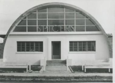
Photograph, 88-90 Sydney Street
17.5cm x 12.5cm black and white photograph of the Spicers Paper Manufacturer building. The building is a domed structure, similar to an aircraft hanger. top half of the building has windows with "Spicers" in front of them.paper manufacturing, architecture -
 Rutherglen Historical Society
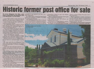
Newspaper article, Historic former post office for sale, 7/02/2018
Article from the Corowa Free Press, Wednesday 7th February 2018, page 7, relating to the former Wahgunyah Post Office, at 5 Foord Street, Wahgunyah. The building was built in 1863 by John Foord for his daughter and son-in-law, Roderick Killborn. It ceased to operate as a post office in 1942. The present owner is Ms Jenny Tutton, who bought the property about two years ago. It is now on sale in the price range $445,000 to $485,000.Newspaper article with coloured photograph of a brick building.wahgunyah, post offices, wahgunyah post office, john foord, roderick kilborn, real estate sales -
 Rutherglen Historical Society
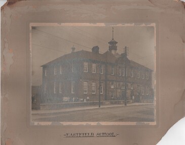
Image, Eastfield School, c1910
Eastfield School is one of the schools in Rutherglen Scotland that, for some years, maintained a relationship with Rutherglen State School No. 522 in Rutherglen Victoria. We have been told by a visitor from Rutherglen Scotland that this building has been demolished.Black and white photograph, mounted on cardboard, showing a two storey school buildingAt bottom of mount: "Eastfield School" Stamped on back: "L. Morrison"schools, rutherglen scotland, rutherglen connection, eastfield school -
Clunes Museum
Document - REPORT, NADIA GASPARETTO et al, CLUNES TOWN HALL AND COURT HOUSE CONSERVATION PLAN, MAY 2000
THE HISTORY AND CONSERVATION POLICY IS AIMED AT RETAINING AND CONSERVING THE BUILDINGCONSERVATION PLAN OF CLUNES TOWN HALL AND COURT HOUSE COMPILED BY NADIA GASPARELTO , ARCHITECT AND HEPBURN SHIRE COUNCIL, INCLUDING PLAN OF BUILDINGLIST OF ILLUSTRATIONS AND PHOTOSclunes town hall, clunes courthouse -
Hume City Civic Collection
Photograph, Bulla Shire Hall
The building in the image was the original Shire of Bulla council offices where councillors met until 1901 when they relocated to Sunbury and conducted their meetings in the Mechanics Institute Hall later known as the Memorial Hall.This building was originally the offices for the Bulla Roads Board and was the first council office built in the bulla shire'A photocopy of a non digital black and white photograph with a cream border of a historic bluestone building.council offices, bulla bulla township, bulla shire hall, bulla shire council, councillors, bluestone -
 Bendigo Military Museum
Photograph - Army Survey Regiment - Fortuna & Surrounds, Bendigo, c1985
This set of 30 photographs of the Army Survey Regiment’s Fortuna Villa and surrounding facilities was taken circa 1985. The photos feature much of Fortuna’s exterior and most of the out-buildings spread over the property’s fifteen acres of grounds. After Defence took possession of Fortuna in 1942, the Q-store and engineering workshops were added during the wartime period. Soldiers were accommodated in tents during WW2 for 20 years next to the parade ground before the construction of accommodation buildings in 1962. In 1990 most of the weatherboard buildings in the Q-store area were replaced. A climate-controlled building was also constructed to house a map library and digital data media. This photo set also includes the exterior of Air Survey Squadron’s Building 16 and two modular buildings -16A and 16B that were added in the early 1980s to accommodate map production and technical services. See item 6457.22P for photos of Fortuna Villa’s interior that were taken at the same time.This set of 30 photographs of the Army Survey Regiment’s Fortuna Villa and surrounding facilities was taken circa 1985. The colour photographs were printed on photographic paper and are part of the Army Survey Regiment’s Collection. The photographs were scanned at 300 dpi. .1) - Photo, colour, c1985. Fortuna Villa – view from the lake. .2) to .4) - Photo, colour, c1985. Fortuna Villa – front view. .5) - Photo, colour, c1985. Fortuna Villa – balcony view of transport compound and Air Survey Squadron. .6) - Photo, colour, c1985. Fortuna Villa – balcony view of Q-store and transport compound. .7) - Photo, colour, c1985. Fortuna Villa – balcony view of transport compound and Bendigo. .8) - Photo, colour, c1985. Fortuna Villa – balcony view of Q-store buildings. .9) - Photo, colour, c1985. Fortuna Villa – Pompeii Fountain and Stables. .10) - Photo, colour, c1985. Fortuna Villa – coach house. .11) - Photo, colour, c1985. Lithographic Squadron delivery docks. .12) - Photo, colour, c1985. Fortuna Villa - Original Roman Bath entry. .13) - Photo, colour, c1985. RAEME and carpentry buildings. .14) - Photo, colour, c1985. Q-store buildings. .15) - Photo, colour, c1985. Q-store buildings. .16) - Photo, colour, c1985. Transport compound. .17) - Photo, colour, c1985. Fortuna Villa’s original laundry, gardeners’ building. .18) - Photo, colour, c1985. Duty Room. .19) - Photo, colour, c1985. L to R: Side of Duty Room, RAP building. .20) - Photo, colour, c1985. Transport compound, Q-store in background. .21) - Photo, colour, c1985. Air Survey Squadron’s Building 16 viewed from carpark. .22) - Photo, colour, c1985. Technical Services, Building 16B. .23) - Photo, colour, c1985. Air Survey Squadron’s Building 16 courtyard. .24) - Photo, colour, c1985. Technical Services, Building 16B viewed from Building 16 courtyard. .25) - Photo, colour, c1985. Air Survey Squadron’s Building 16A and fernery viewed from walkway. .26) - Photo, colour, c1985. Officers Accommodation. .27) - Photo, colour, c1985. Other Ranks (OR’s) ‘New’ Barracks. .28) - Photo, colour, c1985. OR’s Kitchen and Dining Room. .29) & .30) - Photo, colour, c1985. Army Survey Regiment - Front Entry GateThere are brief descriptions on a note behind each photograph.royal australian survey corps, rasvy, army survey regiment, army svy regt, fortuna, asr -
 Sunbury Family History and Heritage Society Inc.
Photograph, Glengala Park Primary School, 3rd March 1993
The building is the Glendale Park Primary School situated in Sunshine West and opened in 1976. The multicultural school with 150+ students from thirty different cultural backgrounds runs a very inclusive program. The students from Bulla Primary School visited on the 3rd March 1993 and enjoyed the day learning about the school and participating in a number of activities with the students. The visit to a school located in one of Melbourne's western suburbs was a contrast to the semi-rural primary school for the students from Bulla Primary School in the 1990s.A non-digital coloured photograph of a red-brick school building.glendale park primary school, bulla primary schooil, school excursions -
 Hume City Civic Collection
Photograph, Bulla Community Centre, c1980s
The building is the Bulla Community Centre, which replaced an older hall that was situated in the Bulla Sports Ground precinct in Greene Street. Over the years many community activities have been staged within the precinct such as district school sports, local dances and community social group functions.A black and white photograph of a brick building with large windows and a return verandah.bulla community centre, bulla township -
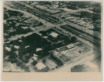 Chelsea & District Historical Society Inc
Photograph - Aerial Photo of Chelsea, c 1923
Points of interest in the photo are Fox Theatre, Chelsea Railway Station and the building site of Masons Theatre on the corner of Chelsea Road and Station Street. Mr William Herbert Hansom was a pioneer of aerial photography in Australia.Black and white aerial photo of Chelsea, bordered by Thames Promenade, Balantyne Avenue, Catherine Avenue and Chelsea Road, Station Street, The Strand, Bath Street.W. H. Hansom ("Manders") Aerial Artist, Personally Conducted Flights over Melbourne and Suburbs St James' Building Bourke Street, Melbournechelsea, aerial photo, station street, chelsea road, the strand, bath street, fox theatre, masons theatre, w. h. hansom, chelsea railway station -
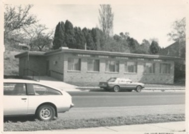 Kilmore Historical Society
Photograph, Kilmore Senior Citizens Club Rooms, 1980's
Is on the site of the Oriental Bank Corporation, but in a different building. 18cm x 12.5cm black and white photograph of the Senior Citizens Club Rooms at 7 Sydney Street Kilmore. Single story brick building with an access ramp on the south side of the building. Two cars are parked on the street, one on each side of the road. Printed on glossy standard photo stock. Possibly the same cite as the Oriental Bank Corporation. Stamped on the back of the item: John Squire Photography 633 Rathdowne Street N. Carlton - Phone 347 4922 NEG No. B4049-16banks -
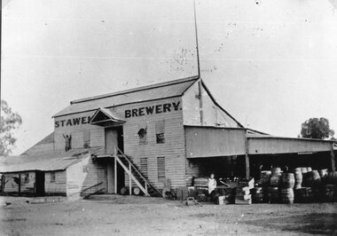 Stawell Historical Society Inc
Photograph, Brewery Building of the Stawell Brewery originally owned by Thomas Powell and later Bryant and Co in Stawell West near the Botanical Reserve
Wooden Brewery Building Stawell Brewery originally owned by Thomas Powell and later Bryant and Co. Located Stawell West near the Botanical Reserve. Closed about 1918.Brewery Building with large flagpole. Worker and barrels on right. Man or boy standing on roof at left.stawell, stawell brewery -
 Federation University Historical Collection
Photograph - Colour, Clare Gervasoni, Ballarat School of Mines E.J. Barker Building, Albert Street, Ballarat, 2017, 26/03/2017
... buildings ...A multi storeyed red brick building on Albert Street Ballarat. It is the E.J. Barker building at the Federation University SMB Campus. ballarat school of mines, e.j. barker building, albert street, buildings -
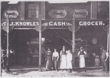 Rutherglen Historical Society
Image, c1890
Black and white photograph of the front of a store with a number of people standing in front of it.Sign above veranda: "J. Knowles Cash Grocer." Sign on the top front of the building: "Graham's Buildings | A.D. | 1897"john knowles, knowles grocery store, j knowles cash grocer, grahams buildings, shops, main street rutherglen -
 Stawell Historical Society Inc
Photograph, Stawell Technical School in Skene Street Stawell
Stawell Technical School, Skene Street Stawell. The school had its first origins in an inquiry in c 1882 by the inspector of Schools of Design. A meeting was called Sept.1882, the first outcome of this meeting, was to advertised for, Friday 12th October 1882 from 7.30 pm to 9.30 pm in the Mechanic's Institute. The School of Mines was opened in the old market building. A complete new building in Patrick Street "Gold Reef Campus".Black & white photograph of a brick building with two pairs of windows on either side of the main entrance, with a parapet. Stawell Technical Schoolstawell building education -
 Ithacan Historical Society
Photograph, Clarendon Street, South Melbourne, 1994
Anthi Chilianis is standing to the right of the building, located in Clarendon Street, South Melbourne, which her family occupied and operated as a fruit shop from 1935 to 1945. When the photograph was taken in 1994 the building functioned as a Commonwealth Bank. The verandah across the front is an original structure. There was an upstairs residence where the Chilianis family lived from 1939 to 1945. It was the ninth house that Anthi had lived in since she arrived in Melbourne. A coloured photograph of a cream building occupied by the Commonwealth Bank in a shopping centre with a lady standing on the extreme right.ithacan businesses -
 Port Melbourne Historical & Preservation Society
Photograph - Outside rear buildings, Administration Building, J Kitchen & Sons, Port Melbourne, Lionel Layfield, 2014 - 2015
Photographs taken by ex-employee of Kitchen's, Lionel Hayfield (refer catalogue numbers 3411 and 3412) just before the building sold to "The Block" - a Channel 9 TV program. See also cat nos 3846, 3847 and 3848First floor series of colour photographs taken inside and from the J Kitchen & Sons Administration Building, Ingles St, Port Melbourne. Details where possible are on the back of the photographs. .01-.04 ; outside rear of buildingsindustry - manufacturing, built environment - commercial, built environment - industrial, demolitions, j kitchen & sons pty ltd -
 Charlton Golden Grains Museum Inc
Photograph, High St Charlton c. 1988, c.1988
High St Charlton looking west from the Armstrong St corner. Buildings on the RH side are the Globe Hotel, Bilton/Dillon building, Westpac Bank, Arundell's Shoe Store. Shire of Charlton photo taken after footpath renovations in 1987-88Colour photograph of High St Charlton looking west from the Armstrong St corner. Buildings on the RH side are the Globe Hotel, Heather's Choice Gift Shop, Mallee Kitchen, Charlton Pharmacy, Westpac Bank. White car parked in front of Globe Hotel building. Bush Poet Cafe sign on LH side of photo.charlton, globe hotel, bilton building, westpac bank, arundell's shoe store, business, armstrong street -
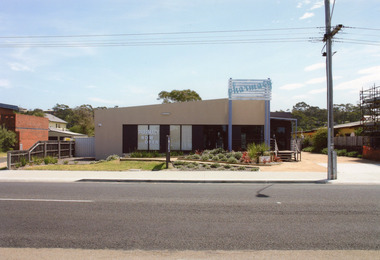 Lakes Entrance Historical Society
Photograph - Kiora Guest House Site, 2008
The pharmacy building has since been removed from this site, it is now vacant. The pharmacy is now situated in the Safeway Arcade.Colour photograph of the pharmacy situated in a temporary building on Esplanade. This site was originally the Kiora Guesthouse. Lakes Entrance Victoriaarchitecture, township, tourism, room display -
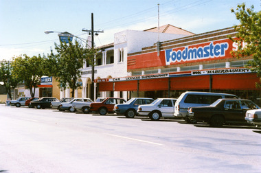 Charlton Golden Grains Museum Inc
Photograph, Foodmaster Supermarket High St Charlton
Originally Luth's General Store purchased from John Flug in 1875. Renovated and enlarges several times over the years. Business sold to Wignall's in 1971, then O'Donnell's, Currans, Carroll & H?son (C&H) and Graeme Paterson purchased the building in 1986. Colour photograph of Foodmaster SUPERMARKET. Signage on the verandah reads C&H LICENCED SUPERMARKET, WOOL, HABERDASHERY. Red blinds down on verandah. Cars parked along the street in front of buildings. White two story building next door, sIgnage reads EAST CHARLTON HOTEL. Sign above building for Quality MEATS further down the street.luth's general store, john flug, wignall's, o'donnell's, curran, c&h, graeme paterson, business -
 Bendigo Military Museum
Painting - SOLDIERS MEMORIAL INSTITUTE
The building is the Soldiers Memorial Institute Pall Mall Bendigo. The period of the painting is between the years 2008 and 2016 after the remodeling of the Forecourt and the major renovations to the building 2016 - 18. This is the first of 3 water colours by Stan Thomas. The building was the HQ of the Bendigo RSL now known as the Bendigo Military Museum. Refer Cat No's 8000.2, 8222, 8224 for the building history.Painting, water colour, timber gold frame, painting is set in two white insets, painting shows a large building greyish colour with a dome on top by artist Stan Thomas.Hand painted on, "RSL Hall Bendigo", "Stan Thomas"brsl, smirsl, painting, rsl hall -
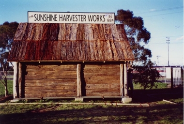 Sunshine and District Historical Society Incorporated
Replica of McKay Smithy, Opened on 10 October 2001
This Smithy is a replica of the building in which the first H. V. McKay harvester was built at Drummartin in northern Victoria in 1884. The original Smithy was moved from Drummartin to Sunshine Victoria where it remained for many years outside the H. V. McKay manufacturing plant. With the construction of the standard gauge railway line the road outside the Smithy was demolished, and the original Smithy was taken to the Melbourne Museum.The original Smithy is now in a fragile state and is no longer on public display at the Melbourne Museum. The site where the original Smithy stood in Sunshine was no longer available so the replica Smithy was erected a few hundred metres away, in the South East corner of Barclay Reserve on King Edward Ave, Albion 3020.The replica Smithy permits the public to view a full sized model of the building which eventually led to the formation of the H. V. McKay Sunshine Harvester Works. This firm grew to being considered the main manufacturing plant in the southern hemisphere, and also led to the local area being renamed in 1907 from Braybrook Junction to Sunshine.Brown wooden building with bark roof. This building is a FULL SIZED REPLICA of the original SMITHY that was used by H. V. McKay.THE SUNSHINE HARVESTER WORKS 1884smithy, h. v. mckay, sunshine harvester works, drummartin, replica, massey harris, massey ferguson -
 Clunes Museum
Photograph, 1869
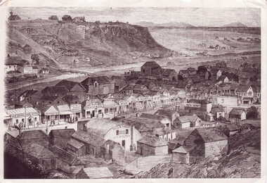
UNION BANK - LATER A.N.Z. NOW PRIVATE RESIDENCE. CORNER OF TEMPLETON ST. NEXT TO C. OF E. - NOW SUNDAY SCHOOL. NEXT TO PRESENT C. OF E. NOTE BELL ON BUILDING NEXT TO RED BOOT WAS A SCHOOL.- TWO CHURCHES ON TOP OF NORTH CLUNES HILL. ONE OF THESE BECAME THE ASSEMBLY HALL AT TOWN HALL. SIGNS ON BUILDINGS, KENT EDWARD DART HOTEL, PITCHER BROS, PORT PHILLIP BAKERY R. HARVEY, C. WILES WASHINGTON HOTEL, R. MORRISON AGE OFFICE NEWS, BULL & MOUTH COACH OFFICE J. H. DALTON.1 PHOTOGRAPH OF A PORTION OF A LITHOGRAPH OF LOWER FRASER STREET, CLUNES. WOODEN BUILDINGS IN FOREGROUND, CRESWICK CREEK BEHIND BUILDINGS. HILL IN BACK GROUND. .2 .3 BLACK AND WHITE COPIES OF THE ABOVE PHOTOGRAPH PRINTED ON GLOSS PAPERshops, red boot palace, clunes township -
 Sunbury Family History and Heritage Society Inc.
Photograph, Former Sunbury Methodist Church
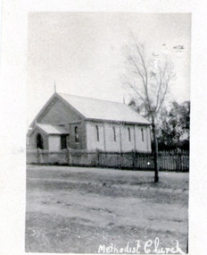
The church in the photograph is the former Methodist Church which is on the NW corner of Barkly and Harker Streets inn Sunbury. It was built on land donated by Thomas Woods at Lot 14 Barkly Street where in 1870 a small weatherboard building was built. In 1879 John Browning gifted land at 13 Barkly Street for the building of a new brick church on that site. The brick church continued to be a place of worship until the June 1977 when the Presbyterian, Methodist and Congregational churches came together and worshipped as the Uniting Church. St. Andrews Uniting Church have been the owners of this building since that time. A non-digital black and white photograph of a little Church building with the words Methodist Church written across the bottom of the image.methodist church, methodism, barkly street, harker street, uniting church -
 Orbost & District Historical Society
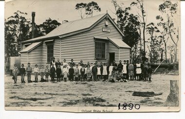
black and white photograph, 1890
This photograph is part of the Mary Gilbert Collection. This photo shows the first Orbost State School which is now known as Ruskin Street Primary School. "The 19th of March 1886 proved an important day in the lives of many early settlers in the Orbost area, because on this day the Orbost State School opened. The fact that the school had first operated temporarily in a leased building, and on a half-time basis with SS2745 Jarrahmond, did not dampen the enthusiasm of the local inhabitants as they saw their offspring commence their education under the guidance of HT Campbell Mackay. However he remained in charge only until 12th of May 1886. The second HT, John Rowe, served until 1908. On 30th of June 1887, a portable room was provided; it being brought to the area by schooner. The school now had accommodation for 30 pupils; the teacher's welfare was considered because quarters of two rooms were attached. As the population increased so did the needs of the school. This was reflected in the provision of a larger classroom in 1898. During 1910-11 the first approaches were made to the Department for the establishment of a HES in Orbost and this became a reality in 1912. Orbost HES supplied post-primary education in the district until a high school was built in 1948. When fire destroyed the school in 1941 local halls were used as classrooms until a new school was built. Work was quite rapid and a new brick structure was opened by the Hon. A. E. Lind, MLA, on 13th of February 1942. This new building was a fine type of school of which both the pupils and the HT Leslie Collins were indeed proud. But Orbost continued to develop and the new school was soon overtaxed. This resulted in the erection of two Bristol classrooms in 1947. By 1950, when the school population had reached 500 pupils the opening of the new school at Orbost North was welcomed by all concerned. In 1963 the Department purchased land diagonally opposite the school and developed it as a playing area. In 1965 two LTCs were opened in November, and in October 1968 the Brodribb School building was moved to SS2744 Orbost for use as a general purpose room." (re.f Schools East Gippsland")This item is associated with education in Orbost.A black / white photograph showing a group of children posed in front of a wooden school building. A sign on the building has "STATE SCHOOL No. 2744"3127.1 - "front row left is W.J. Cameron" 3127.2 - "Teachers, Mr Rowe, Miss Lucy Watt (sewing) back row Mrs Kerr (Hilda Temple) Miss Hofen back left W. Roadknight 4 from left back Annie Cameron 1 left centre row" 3127.3 - as per above education-orbost state-school-orbost -
 Lakes Entrance Historical Society
Photograph - Information Centre Lakes Entrance, 1993
Original centre was built by voluntary labour, a Chamber of Commerce initiative, officially opened November 1987, by Joan Kirner, building extension completed April 1993.Black and white photograph of the Tourist Information Centre, following building extension works. Lakes Entrance Victoriatourism, public utilities -
 Charlton Golden Grains Museum Inc
Photograph, Brownjohn, Reg, Rear of Johnson's Bridge Store c. 2000, c.2000
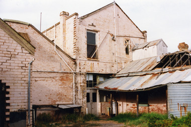
Derelict rear of building built as Bridge Store in 1872 for Peter Johnson, later Wylie's Building and a furniture store. Photo taken for the Museum by R. Brownjohn.Colour photograph of the rear of an old, brick two storey building. Building appears derelict and disused. Part of the roof is missing on the lower section and the beams are exposed. Verandah is sagging. Gas tank/hot water service in corner in the centre of the photo. Single door to the right of the gas tank and double doors to the left. One large and one small window in the upstairs section. Chimney on LH side of upper storey.bridge store, peter johnson, wylie's building, charlton, business -
 Sunbury Family History and Heritage Society Inc.
Photograph, Former Yakka Factory
In the 1950s there was a move to bring some light industries into Sunbury. The large building in Barkly Street, which was used to make gloves and other items of clothing was taken over by the Yakka Company and boys shorts were made there. In the 1960s the Yakka Company moved to new and larger premises in Broadmeadows resulting of the closure of the Sunbury factory. A car park which services the business owners and employees from O'Shanassy Street now occupies the site.The Yakka Factory was one of the early manufacturing ventures to be started in Sunbury.A non-digital scanned copy of a coloured photograph of a large shed-like building with two utility trucks parked in the street in front of the building. There are some tall shrubs on either side of the building and a tall electric light pole on the RHS of the picture.He photograph has a narrow cream border.yakka factory, barkly street, manufacturing