Showing 11032 items matching "gippsland"
-
![Painting - Artwork, Rodney Forbes et al, [Printery], c1982](/media/collectors/530576742162ef0fa09a2288/items/57ecace9d0cdd12be41850de/item-media/57ecad44d0cdd12be4188585/item-fit-380x285.jpg) Federation University Art Collection
Federation University Art CollectionPainting - Artwork, Rodney Forbes et al, [Printery], c1982
Rodney FORBES (1951- ) Born Melbourne Rodney Forbes' work is figurative narrative painting and uses autobiographical and incident-as-metaphor methods to explore wider issues of knowing and belonging in oral traditions such as working class, children’s and artisan subcultures. His practice draws on pop, cartooning and joke narrative structures within contemporary culture. (http://www.australiangalleries.com.au/artists/rodney-forbes/, accessed 07 April 2017)A large painting showing aspects of a printery. Rodney Forbes and fellow student Linda Karklins worked on this painting as an undergraduate student at the Gippsland School of Art (Gippsland Institute of Advanced Education, now the Gippsland Centre for Art and Design, Federation University Gippsland Campus). The painting hung for many years in the campus printery. The Gippsland Gippsland Centre for Art and Design is now part of Federation University Gippsland Campus.rodney forbes, printery, gippsland campus, churchill, linda karklins, gippsland school of art, gippsland institute of advanced education, printing -
 Marysville & District Historical Society
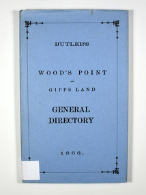
Book, Butler's Wood's Point and Gipps Land General Directory 1866, 1985
A directory of the local businesses, road guides and table of distances in the Wood's Point, Jamieson, Omeo and Bairnsdale areasHardback. Blue dust cover. Title in black on the front cover.Stamp of the Marysville & District / Historical Society Inc / P.O. Box 22 / Marysville 3779directory, wood's point, gippsland, victoria, history, jamieson, bairnsdale, omeo, road guide, table of distances, advertisements -
 Orbost & District Historical Society
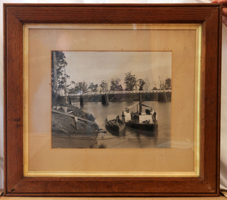
framed black and white photograph, C1900
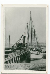
The P.S. Curlip was built by Samuel Richardson & Sons at a Tabbara sawmill in 1889. Alan Richardson, shown in the photograph, was the captain. It was operated along the Snowy River in Australia's Gippsland region between 1890 and 1919, before being washed out to sea, and broken on Marlo beach, by a flash flood in 1919. James Winchester was born in Geelong in 1856. He first sailed into Marlo, aged 15 and returned in the 1870's. he worked on the snagging punt on the Snowy River and also on the Paddle Steamer Curlip which towed the barges to collect the maize grown along the Snowy River. Wooden chutes were constructed along the river banks to load bagged maize onto the barges. The bags of maize were sent down the chutes into the waiting barges. This is a pictorial record of the iconic Paddle Steamer Curlip which has a significant association with Orbost. It records the method of loading maize onto barges through a wooden cchute.A large framed black / white photograph of the Paddle Steamer Curlip and a barge on a river. The barge is being loaded with maize through a large chute. In the background is the Snowy River bridge. the frame is wood. There is also a copy.on back of copy - " Jim Winchester, Alan & Frank Richardson, Curlip - barge & chute for loading maize"p.s.-curlip transport-shipping richardson winchester-james snowy-river maize-loading -
 Orbost & District Historical Society
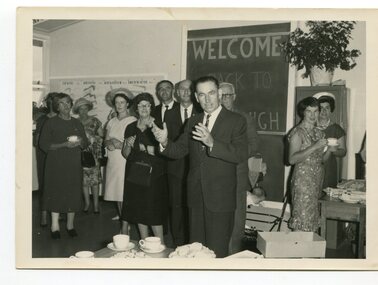
black and white photograph, 1962
This photo shows Bert May addressing a group of ladiers at the 1962 Golden Jubilee of the Orbost High School. Bert May served as the Member for Gippsland in the Legislative Council from 1957 until 1973. With earlier levels of schooling available at the Orbost State School or nearby schools of Newmerella and Jarrahmond School, it was not until April 1912, and after much campaigning from parents and other notable community members, that the Orbost Higher Elementary School was opened. Mr Richard Trembath was appointed the new Head teacher of Orbost Higher Elementary School and was assisted by Miss Olga Hirst. The senior class consisted of 26 pupils, and the junior class, 16 pupils. A limited curriculum was available which included lessons in Latin, Arithmetic, Algebra, Geometry, Geography, History, Drawing and advanced English. (ref. O.S.C. website)Orbost High School / Orbost Secondary College has played a significant part in the education of senior students in the Orbost district . It is the sole senior educational institution. This item is representative of its history and is a useful reference tool.A black / white photograph of a man giving a speech to a group of ladies in a classroom. all are standing.on back - Bert May, Orbost H.S. Jubilee 1962orbost-education orbost-high-school -
 Orbost & District Historical Society
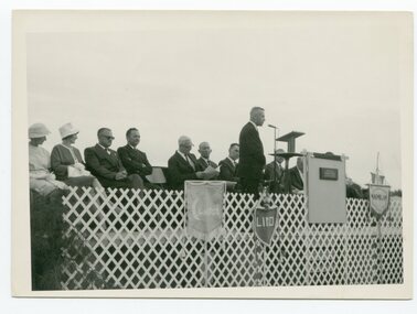
black and white photograph, 1962
This photograph was taken at the Golden Jubilee of Orbost High School in 1962. Bert May is addressing crowds. Bert May served as the Member for Gippsland in the Legislative Council from 1957 until 1973. With earlier levels of schooling available at the Orbost State School or nearby schools of Newmerella and Jarrahmond School, it was not until April 1912, and after much campaigning from parents and other notable community members, that the Orbost Higher Elementary School was opened. Mr Richard Trembath was appointed the new Head teacher of Orbost Higher Elementary School and was assisted by Miss Olga Hirst. The senior class consisted of 26 pupils, and the junior class, 16 pupils. A limited curriculum was available which included lessons in Latin, Arithmetic, Algebra, Geometry, Geography, History, Drawing and advanced English. (info. from O.S.C. website.Orbost High School / Orbost Secondary College has played a significant part in the education of senior students in the Orbost district . It is the sole senior educational institution. A black / white photograph of Mr Bert May, on a stage, addressing an audience, most seated, some standing behind him.back - hand-written - "Orbost H.S. Jubilee, 1962 - Bert May".orbost -education orbost-high-school -
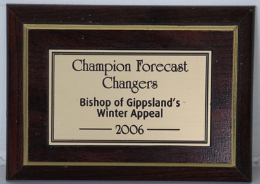 Grey Street Primary School, Traralgon
Plaque, Champion Forecast Changers
Bishop of Gippsland's Winter Appeal 2006 -
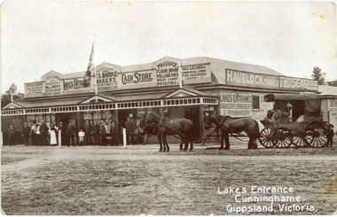 Lakes Entrance Historical Society
Photograph - Barke's Store, 1900c
This is the before paired photograph used in the 150 year, Lakes Entrance 1858-2008 display.|The after paired photograph number is 01402.1|Also one 12 x 16 framed photograph used in room display.Black and white photograph of Barkes Store. Store was built in 1893, opposite the Post Office on Esplanade. Photo shows a large weatherboard building, hipped iron roof, imitation gables and timber frieze decorate the veranda roof. Building has many signs advertising various goods, products and services. A four-horse drawn wagon and crowd of people at front of the store, on ground-level wooden veranda floor. Lakes Entrance VictoriaLakes Entrance Cunninghame Gippsland, Victoriatransport, township, retail trade, room display -
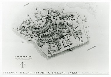 Lakes Entrance Historical Society
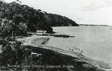
Photograph - Bullock Island, 1991
Date made September 1991Black and white photograph of a concept plan for a proposed multi million dollar tourism complex to be built on Bullock Island, Lakes Entrance, Victoria.Bullock Island Resort Gippsland Lakes islands, development -
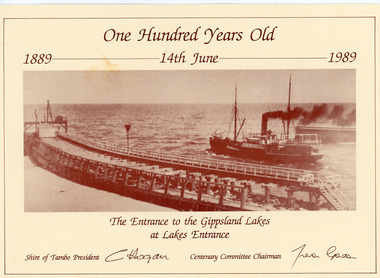 Lakes Entrance Historical Society
Postcard - The Entrance, 1989
Card printed by Shire of Tambo for the Centenary 14 June 1989, original photo taken 1910cSepia photograph on card advertising 100 years celebration 1889 - 1989 of opening of the Entrance. Photo shows S S Wyralla going out to Bass Strait and the original wooden piers, at Lakes Entrance, Victoria.The Entrance to the Gippsland Lakes at Lakes Entrancehistoric site, celebration -
 Bendigo Historical Society Inc.
Document - ROYAL HISTORICAL SOCIETY OF VICTORIA - MEETING MINUTES - 16/02/1985, 16 Feb 1985
Document. Four-page copy of the minutes of the quarterly meeting of the State Committee of Member Societies. Meeting held on 16 Feb. 1985 at the headquarters of the Royal Historical Society of Victoria, 1 City Road, South Melbourne. Apologies recorded from Miss F Kingerlee of the Bendigo Branch. On top left of front page handwritten in red biro 'Alec H Stone'.Mr J Irving (Gippsland) Chairmandocument, royal historical society of victoria, meeting minutes, miss f kingerlee, alec h stone. -
 Lakes Entrance Historical Society
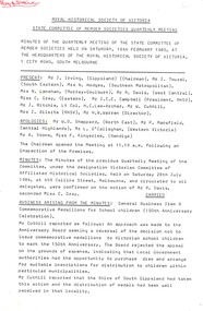
Photograph - Kalimna Jetty, Valentine Series, 1915c
Black and white photograph of the lake shore at Kalimna, showing Kalimna jetty and storage shed, low sandy shore in foreground contrasting with steep cliffs beyond jetty. Indistinct distant view of New Works area at southern shore of Cunninghame Arm. Lakes Entrance VictoriaKalimna Lakes Entrance Gippsland Victoriajetties, waterways -
 Lakes Entrance Historical Society
Photograph - Bullock Island, Lakes Post Newspaper, 1991
Date made September 1991Black and white photograph of the concept plans for the boat harbour of the proposed tourism facility on Bullock Island, Lakes Entrance, Victoria.Bullock Island Resort Gippsland Lakes islands, commercial development -
 Department of Energy, Environment and Climate Action
Phillips FM 828 Radio
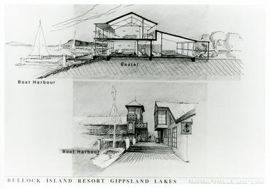
After the 1939 bushfires, the Forests Commission Victoria invested heavily in a radically new communications network. After suffering some inevitable delays due to the war, radio VL3AA switched into full operation in October 1945 proudly beaming out 200 watts across the State. But by today’s standards, the technology was primitive and the reception poor unless the user was on a high point somewhere. The radio signal was "line-of-sight" and bounced between fire towers and relay transmitters across the mountains back to the District offices. The advent of solid-state electronics in the 1960s replaced the more delicate valve sets which enabled greater use of vehicle mounted radios. The Commission continued to research, develop and build new radios at its many workshops around Victoria. The network was supported by a large team of skilled radio technicians. The more secure and versatile State Mobile Radio (SMR) digital trunk system came into operation in about 1995. Upgraded Tait Radios were purchased in 2014 after recommendations of the 2009 Bushfires Royal Commission. But it was the convergence of separate technologies such as 5G mobile phones, high-capacity and light-weight lithium batteries, Wi-Fi, the ever-expanding internet, cloud data storage, digital cameras, GPS, personal organisers and hundreds of supporting Apps into powerful smartphones and tablets which revolutionised bushfire communications from the mid-2000s. Aircraft radio with handsetCentral Gippsland Region 09/067bushfire, radios, forests commission victoria (fcv) -
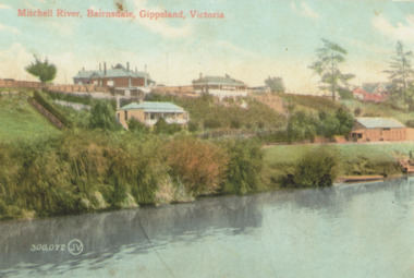 Lakes Entrance Historical Society
Photograph - Mitchell River Bairnsdale Victoria, 1910 c
Copy of old hand coloured postcard of Mitchell River showing St Johns Church top right, rowing club boat shed bottom right with steps down to river and landing Bairnsdale VictoriaMitchell River Bairnsdale Gippsland Victoriabridges, rivers, churches -
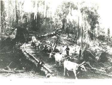 Lakes Entrance Historical Society
Photograph - two bullock teams , Tambo Crossing Victoria, 1900
Black and white photograph of two bullock teams and drivers hauling large logs down a steep bush track first team crossing a log bridge, man on bridge, Tambo Crossing VictoriaNear Tambo Crossing East Gippslandaccommodation, hotels, transport -
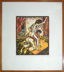 Federation University Art Collection
Artwork - Printmaking, 'Blind Date' by Stewart MacFarlane, 1992
Stewart MacFARLANE (1953- ) Born Adelaide, South Australia Stewart MacFarlane entered the South Australian School of Art when 16 years of Age. He traveled to New York in 1975 to study at the School of Visual Arts for 2 years. He remained living and working in New York for several years, receiving residences and fellowships to Skowhegan School of Sculpture and Painting in Maine, the Fine Arts Work Center in Provincetown, Massachusetts and the MacDowell Colony, New Hampshire. He exhibited in group shows as well as having three solo exhibitions in New York. Firstly at Razor Gallery, SoHo in 1979, then Belanthi Gallery in 1979 and the Australian Consulate New York in 1983. MacFarlane returned to Australia in 1983, undertaking post-graduate studies at the Victorian College of the Arts in 1984. He taught at The Gippsland Institute of Advanced Education (now Federation University Gippsland Campus) in 1885, and the following year moved to Darlinghurst, Sydney to paint. Later that year, he was artist-in-residence in the Besozzo Studio, Italy. In 1987, MacFarlane lived and painted in Mornington, Victoria for several months before receiving an initial residency with the Roswell Artist-in-residence program, New Mexico, for a year. Over the next eight years he moved between Melbourne, Sydney and Roswell, producing one or more solo exhibitions each year. In 1994 he received a residency at The Bemis Center, Omaha, Nebraska, then traveled to Mexico to paint for 3 months. MacFarlane worked in Queensland upon his return, and for the next seven years. He moved to Hobart, Tasmania in 2002, returning to the mainland in 2011.(http://www.stewartmacfarlane.com/bio-cv/) A framed linocut. This linocut was one of the Patron Print Series produced as a fundraiser to assist Gippsland School of Art students.printmaking, artist, artwork, gippsland campus, stewart macfarlane -
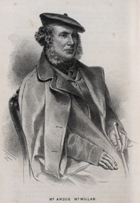 Federation University Historical Collection
Drawing - Image - black and white, Angus McMillan, c1835
Angus McMillan named the Avon River after the river of the same name in his native Scotland. In 1840 he established a pastoral run at Bushy Park, north-west of the township. William Odell Raymond established a run in the area in 1842, and built his house, Strathfieldsaye, during 1848–54. European settlement did not take place without resistance, and in return, massacres were inflicted by Angus McMillan and others on Gunai people, especially between the years of 1840 and 1850. (wikipedia) The first application for the 'Bushy Park' run appears in the “Port Phillip Gazette” on 13 August 1843. It was taken up by Angus McMillan, who also took up the 'Boisdale' run for his employer Lachlan Macalister at the same time. In March 1844 a Licence to occupy the 16,000 acre 'Bushy Park' was granted to McMillan. In the late 1840s Andrew Martin and Matt McCraw built Angus McMillan's Bushy Park homestead. Aboriginal killings in Gippsland area most often were never formally recorded, but lived on in folklore, mainly in place names pinpointing what some historians now refer to as "massacres", and others as "conflicts". There is Boney Point, on Lake Wellington, Butchers Creek, near Metung, Slaughterhouse Gully, at Buchan, Skull Creek, at Lindenow, and, notoriously, Warrigal Creek, at Woodside. "Here, according to a couple of contemporary - though not eyewitness - reports, between 50 and 150 blacks were killed in an orgy of revenge after the murder and mutilation of a leading Scots settler, Ronald Macalister. If anybody had any doubts about the fitness of commemorating McMillan's name, no one voiced them then. Gippsland was, and still is, dotted with stone cairns tracing his route from Omeo, down the Tambo Valley to the fertile plains where he was to make (and lose) his fortune. And where, according to a growing body of opinion, he was to lead the "Highland Brigade", a band of armed settlers, against the Kurnai. History is fiction agreed on, and it is written by the winners. For most of the past 150 years, McMillan has been hailed as a trail-blazing pioneer. The legend began to crumble 20 years ago with publication of new histories, which at first outraged Gippsland historical societies and old residents, but which have gradually changed the way McMillan is viewed. ... Still, not all McMillan's contemporaries agreed with the "Highland Brigade" and its methods. Henry Meyrick, an English-born squatter, wrote to relatives in disgust about his neighbours. He estimated that 450 had been killed, and wrote: "Men, women and children are shot down whenever they can be met with. Some excuse might be found for shooting the men by those who are daily getting their cattle speared, but what they can urge in their excuse who shoot the women and children I cannot conceive." (http://www.theage.com.au/articles/2002/04/26/1019441303552.html, accessed 20 September 2016.) The Gippsland electorate is called 'McMillan' in his honour. Black and white image of a man wearing a coat and beret. He is Scottish born Victorian Squatter Angus McMillan of Bushy Park, Gippsland.angus mcmillan, squatter, aboriginal massacre, bushy park, gunai, avon river, pioneer -
 Orbost & District Historical Society
brochures, Snowy River Mail as "Mail" Print, Shire of Orbost Information Brochure, December 1970
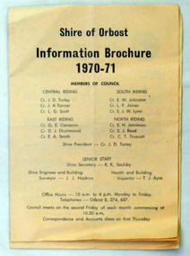
The Shire of Orbost was a local government area about 380 kilometres east of Melbourne, the state capital of Victoria, Australia. The shire covered an area of 9,347 square kilometres ), and existed from 1892 until 1994. Originally, Orbost was part of the Bairnsdale Road District which was created on 30 April 1867. Splitting away as part of the Shire of Tambo in 1882, Orbost was first incorporated as a shire in its own right as the Shire of Croajingolong on 30 May 1892. It received its present name on 17 February 1893. On 3 January 1913 part of its western riding was annexed to Tambo as its Cunninghame Riding. On 2 December 1994, the Shire was abolished, and merged with City and Shire of Bairnsdale, Shire of Tambo, most of Shire of Omeo and the Boole Boole Peninsula from Shire of Rosedale into the Shire of East Gippsland This is a useful research tool.Two copies of a triple fold paper brochure. It is titled"Shire of Orbost Information Brochure" in black print. It contains the names of councillors, staff, the work program and budget.shire-of-orbost -
 Orbost & District Historical Society
booklet, Snowy River Mail, Shire of Orbost By Laws No 28, 1920's
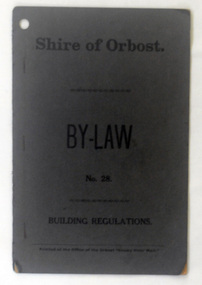
This booklet contains by law No 28 pertaining to building regulations. The Shire of Orbost was a local government area about 380 kilometres east of Melbourne, the state capital of Victoria, Australia. The shire covered an area of 9,347 square kilometres ), and existed from 1892 until 1994. Originally, Orbost was part of the Bairnsdale Road District which was created on 30 April 1867. Splitting away as part of the Shire of Tambo in 1882, Orbost was first incorporated as a shire in its own right as the Shire of Croajingolong on 30 May 1892. It received its present name on 17 February 1893. On 3 January 1913 part of its western riding was annexed to Tambo as its Cunninghame Riding. On 2 December 1994, the Shire was abolished, and merged with City and Shire of Bairnsdale, Shire of Tambo, most of Shire of Omeo and the Boole Boole Peninsula from Shire of Rosedale into the Shire of East Gippsland. This item is a useful research tool.A dark grey, stapled, paper covered booklet with title "Shire of Orbost By Law No 28" in black print. -
 Orbost & District Historical Society
information sheet, Welcome to the Shire of Orbost, 1992
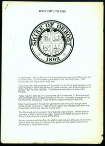
This was possibly produced for an open day in the centenary year. The Shire of Orbost was a local government area about 380 kilometres east of Melbourne. The shire covered an area of 9,347 square kilometres and existed from 1892 until 1994. Originally, Orbost was part of the Bairnsdale Road District which was created on 30 April 1867. Splitting away as part of the Shire of Tambo in 1882, Orbost was first incorporated as a shire in its own right as the Shire of Croajingolong on 30 May 1892. It received its present name on 17 February 1893. On 3 January 1913 part of its western riding was annexed to Tambo as its Cunninghame Riding. On 2 December 1994, the Shire was abolished, and merged with City and Shire of Bairnsdale, Shire of Tambo, most of the Shire of Omeo and the Boole Boole Peninsula from Shire of Rosedale into the Shire of East Gippsland. This is a useful reference tool.Two stapled pages of printed information. On the front page is the logo of Orbost Shire Council. There is information on the role of the Shire Councillors for 1992/93. It has a map of the council building.orbost-shire-council -
 Orbost & District Historical Society
black and white photograph, before 1912
This photo shows the Storm Bird at the end of the jetty and the Wangrabelle in the foreground. Both ships were well known traders. the Wangrabelle became beached and wrecked in 1916 and the Storm Bird became obsolete when the railway from Bairnsdale to Orbost arrived in 1916. (ref. Story of Gippsland Shipping - J.C. Bull) At the start of the river trade goods were shipped from Marlo to Melbourne but when the railway reached Bairnsdale this became unprofitable and the ships plied only between Marlo and Cunninghame. Eventually river transport became economically unviable. The Wongrabelle is still buried in the sands of the entrance of the Snowy River (albeit where the entrance used to be). It took from April 11th 1912 to August 12th 1912 for the loss of the Wongrabelle to be complete, the final entry in the Orbost Shipping Co. records reads:- "The Wongrabelle is completely covered in sand." (ref River, Road, Railway Newsletter O.D.H.S.) This is a pictorial record of a time when the water highways were the only feasible transport mode in sending goods from Orbost and Marlo to Melbourne.A black / white photograph of a ship, sails down, anchored at the Marlo jetty.on back - "M. Gilbert, Wangrabelle at Marlo"storm-bird wangrabelle shipping transport- marlo -
 Orbost & District Historical Society
black and white photograph, late 19th century - early 20th century
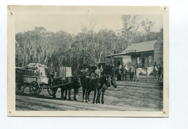
This is a photograph of Alice Swallow's hotel at Cabbage Tree. The settlement of Cabbage Tree Creek is located on the Princes Highway, 27 km east of Orbost in East Gippsland. The first white settler arrived in the valley in 1887 cutting a dray track from Marlo to the south-west. Several families cleared the alluvial flats, growing maize, peas and beans and raising pigs, cattle and sheep. Later the farmers milked cows, sending cream to Orbost. In the late 1890s, small quantities of alluvial gold were found in the creek. A school commenced classes in 1913, but enrolment was small and at times the school operated part time with several other small schools in the area. The school building served as a hall for the district. From the 1920s the Cabbage Tree Hotel catered to drivers on the improved Princes Highway. (info. from Victorian Places)This is a pictorial record of Cabbage Tree, East Gippsland in the late 20th century. It shows a building that no longer exists.A black / white photograph of a small, single - storey wooden building in a bush setting. There are people standing in front of the building with a horse and wagon nearby. In the foreground is a wagon with four horses hitched to it and the driver seated behind the horses. -
 Orbost & District Historical Society
photograph, C 1900
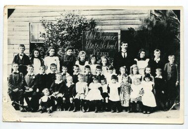
Club Terrace, situated in East Gippsland, is important as a timber milling centre. The name probably derived from the ‘Ace of Clubs’ mine which operated for a time there and which took its name from the ‘Ace of Clubs’ cattle brand of still earlier days. The school first opened on 1st of February 1900, the teacher being Samuel Beaver. In 1960 the number of children enrolled grew too great for the little one-room school that had served so well. A modern type school of two rooms, built on a new site away from the mills, was occupied at the beginning of the 1961 school year when R. Lawry and his wife were the teachers. Later in the same year the school was officially opened by the DI Cyril Bowden. Also present were B. Evans, MLA, B. May, MLC and several Councillors from Orbost Shire. This school record is of immediate interest and value to the pupils and staff who have learned and taught in the Club Terrace State State School. The record also has a much wider significance, to the community in which the school is situated, as a record and research tool.A black / white photograph of a group of students and their male teacher standing outside a wooden building. It is labelled " Club Terrace State School No. 3343"on back - "about 1898"education club-terrace-state-school -
 Orbost & District Historical Society
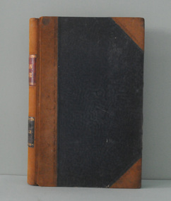
ledger, 1. 8. 1915 - 30 .6. 1923
This ledger was kept by the management of a rural property in Marlo, East Gippsland. Entries were made by Hugh Cameron and Alaster Cameron. Their property was reputed to be the largest private dairy producer in Australia at one stage. (ref. Mary Gilbert) Some station owners or managers kept records like diaries, wage and ration books, and registers of births, deaths and marriages. This one records federal transactions, costs of produce and payments for share farming at Brodribb and Marl, as well as a list of donations made. Hugh Cameron (1850-1921) was on the Orbost Shire council from 1892-1915. His son Alaster was also an Orbost Shire councillor representing the East riding from 1932 to 1954. Hugh died at Orbost on 3rd May 1921, aged 71, and was buried on 5th May at the Orbost cemetery. (more info. in O.D.H.S. newsletter -Tambo Shire)This is an example of record keeping on rural properties in the first half 20th century. It is associated with the Cameron family who were early settlers in the Orbost district.A large leather bound ledger with a dark blue patterned cover and suede leatherette binding and corners. There are pages with alphabetical indexing. Some pages are ruled for accounts. All entries are hand-written in blue or black ink.There is blotting paper inside.on spine on red leatherette in gold print - " "STATION LEDGER" and on black in gold print - "CLOVERDALE"cameron-marlo dairy-farm-cameron agriculture-records station-ledger-cameron -
 Orbost & District Historical Society
black and white photographs, 1890s
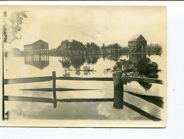
Peter Cameron, came to Orbost in 1885, at the age of 69, having sold his farm at Geelong. Peter bought the property ―Glen Avon from a Mr Street. The home was situated at the bottom of the paddock, near the corner of Morley and Livingstone streets. The farm stretched from Tennyson Street to the end of Snaggers Lane and along the river frontage to “Carinya” Cameron Home. In the Gippsland Times on Wednesday. 2 Jul 1890 on Page 3 is an article titled "THE SNOWY RIVER CALAMITY" which describes an ".unexpectedly sudden rush of water down the flats..... the terrified people commenced to remove their stock from the land and the work of saving property was continued all day ............ many head of cattle were washed away.......The river road, for its entire length, is obliterated, and the approaches to the bridge at Watt's Gulch are gone, with the enormous volume of flood water," These photographs are pictorial records of a significant event in the history of Orbost. There are few personal records of the very early floods.Three black / white photographs of wooden buildings with flood water in foreground. There are post and rail fences. 3193.2 has been taken from a distance.on back -" "Glenavon east of Lagoon 1897 Feb"floods-orbost-1890s glenavon-orbost -
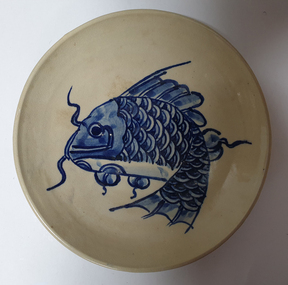 Federation University Art Collection
Ceramic, "Fish Plate" by Masako, c1981
Masako was a visiting lecturer to the Gippsland Centre for Art and Design (GCAD) in 1981.Stoneware plate with blue brushwork. Fish decoration. masako, ceramics, gippsland, jan feder memorial ceramics collection, gippsland campus, fish, visiting artist -
 Ambulance Victoria Museum
Vehicle, motor, ambulance, Mercedes Benz Sprinter, 2006, 2006
This ambulance is typical of thise used throughout Victoria in the 2000's. A very comfortable and manageable ambulance. It was stationed with the Gippsland Ambulance in Loch Sport, Victoria.A Mercedes Benz Sprinter four-wheeled vehicle fitted out as an ambulance. Body painted white with red and silver diagonal stripes in a strip along the mid-section of each side panel. The word Ambulance is written (in mirror image0 across the front of the vehicle.Registration number UHG 147motor vehicle, ambulance, mercedes benz, mercedes benz sprinter, gippsland -
 Orbost & District Historical Society
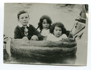
black and white photograph, Warren, Mrs H, late 19th century - early 20th century
This is a photograph of Jack Warren, Jessie and Sylvia McNaughton. The photographer was Warren, Helena (1871-1962) who was a self-taught photographer who became both the local press correspondent and a producer of humorous trompe l'oeil postcard images. Helena Warren was a thirty-two year old settler living on a small mixed farm with her husband, William, at Newmerella, near Orbost in Gippsland, Victoria, when she bought her first camera, an Austral Box quarter-plate. Her family says she was entirely self-taught, like many women photographers who started out with nothing but the instructions on the packets of film and chemicals. In over fifty years practice she graduated from the total novice, who opened all her first mail order plates in bright sunlight and ruined them, to a competent photographer who became both the local press correspondent and an inveterate producer of humorous trompe l’oeil postcard images.This photograph has significance in its association with Helen Frances Warren, a popular Orbost identity who was well known as an accomplished photographer and needleworker.A black / white photograph of three young chilodren sitting in a pumpkin in water. There is a Union Jack at each end.pumpkins-orbost warren-helena-photographer mcnaughton-jessie mcnaughton-sylvia -
 Orbost & District Historical Society
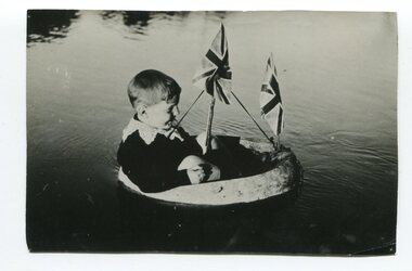
black and white photograph, Warren, Mrs H, late 19th century - early 20th century
The photographer was Warren, Helena (1871-1962) who was a self-taught photographer who became both the local press correspondent and a producer of humorous trompe l'oeil postcard images. Helena Warren was a thirty-two year old settler living on a small mixed farm with her husband, William, at Newmerella, near Orbost in Gippsland, Victoria, when she bought her first camera, an Austral Box quarter-plate. Her family says she was entirely self-taught, like many women photographers who started out with nothing but the instructions on the packets of film and chemicals. In over fifty years practice she graduated from the total novice, who opened all her first mail order plates in bright sunlight and ruined them, to a competent photographer who became both the local press correspondent and an inveterate producer of humorous trompe l’oeil postcard images. This photograph has significance in its association with Helen Frances Warren, a popular Orbost identity who was well known as an accomplished photographer and needleworker, A black / white photograph of a young boy in a carved out pumpkin in water. It has two flags.warren-helena-photographer pumpkins-orbost -
 Orbost & District Historical Society
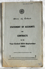
statement of accounts, Shire of Orbost Statement of Accounts, 1963
This document was made by the Shire of Orbost, local government. The Shire of Orbost was a local government area about 380 kilometres (236 mi) east of Melbourne, the state capital of Victoria, Australia. The shire covered an area of 9,347 square kilometres (3,608.9 sq mi), and existed from 1892 until 1994. Originally, Orbost was part of the Bairnsdale Road District which was created on 30 April 1867. Splitting away as part of the Shire of Tambo in 1882, Orbost was first incorporated as a shire in its own right as the Shire of Croajingolong on 30 May 1892. It received its present name on 17 February 1893. On 3 January 1913 part of its western riding was annexed to Tambo as its Cunninghame Riding. On 2 December 1994, the Shire was abolished, and merged with City and Shire of Bairnsdale, Shire of Tambo, most of Shire of Omeo and the Boole Boole Peninsula from Shire of Rosedale into the Shire of East Gippsland. Local governments play an important role in the lives of citizens in Australia. Local government authorities exist to provide services and amenities to local communities, and are also responsible for regulating and providing services for land and property in their district. This item is representative of a time when Orbost had its own Shire Council. A document with a light blue cover, black print. It is a "statement of accounts for the Shire of Orbost for the year ended 30th September, 1963".document-statement-of-accounts orbost-shire