Showing 4487 items
matching cities and towns
-
 Kew Historical Society Inc
Photograph, C.S. Tompkins (Ainar Studios), Kew Council Cricket Team, 1922-1924
Historically significant and rare photograph of Kew Councillors playing in a Cricket Team in the early 1920s.Kew Council Cricket Team. The City of Kew at times had its own cricket team. Identified players of the 1922-23 team include: Back row, left to right: Cr. Coleman, Cr. Edwards, Staff, Staff, Cr. Barnard, Mr Birrell, Cr. Wishart. Front row, left to right: Cr. Ramsey, Cr. Woolcock (Mayor), C. Cole, and Cr. Carnegie. Of the eight councillors in the team, each either had been or would be Mayors of Kew: William Wishart (1906-07), Jabez Carnegie (1908-09, 1924-25, 1934-35), Francis Barnard (1920-21), Henry Coleman (1921-22, 1929-30), James Woolcock (1922-23, 1923-24), George Ramsey (1925-26), George Cole (1926-27), and Percy Edwards (1928-29). W. D. Birrell became Town Clerk of Kew in 1938. The photographic studio's name at front is identified as C.S. Tompkins Ainar Studios, Auburn. Annotation on reverse include the names of the players, an original accession number "KH-22" and information about donor "Presented by Joy Stewart, given to her by the Edward[s] family, Mr Edward[s] once Mayor of Kew (1928-29)city of kew, kew councillors and staff, sports -- cricket -- kew (vic.) -
 Melbourne Tram Museum
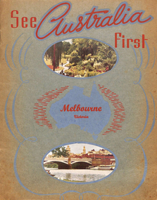
Book, Murray Views, "See Australia First - Melbourne Victoria", c1950
Book - 16 pages, including grey card covers, titled "See Australia First - Melbourne Victoria" featuring 12 pages of postcard photographs of Melbourne. Inside rear cover has a details of Melbourne's history, the city and its features. Produced by Murray Views of Gympie Qld, printed by Samuel Lee and Co. Images post second world war - late 1940's to early 1950's. Features images of: Alexandra Gardens River Yarra and Princes Bridge Flinders St Station St Kilda Road - tram track work being undertaken Flinders St and the Forum theatre The Exhibition Buildings Collins St Parliament House Bourke St - with cable tram tracks and the Metropole Hotel, Myer, Foys Aerial view of Melbourne Captains Cook's Cottage St Kilda Road with W2 287 Burns Memorial St Kilda Road St Paul's and Princes Bridge Town Hall Royal Melbourne Hospital Collins St with W2 turning Queen Victoria Gardenstrams, tramways, melbourne, flinders st station, collins st, town hall, princes bridge, st kilda rd -
 Bendigo Historical Society Inc.
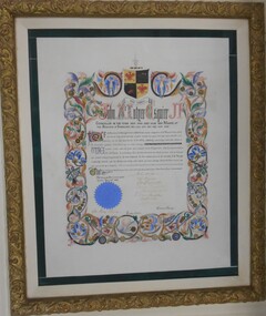
Award - ILLUMINATED ADDRESS :JOHN MCINTYRE ESQUIRE, 24/04/1868
Illuminated Address given to John McIntyre Esquire for his time in the Bendigo City Council in the years 1859 - 1860 - 1862 and Mayor of the Borough of Sandhurst: 1863, 1864, 1865, 1866, 1867, 1868. Signed by Councillors, John Holmes, Robert Burrowes, George Aspinall, James Boyd. M.D., J. Holdsworth, D. Macdougal, Ed. Garsed, John Latham, Town Clerk, George Avery Fletcher. Coloured hand drawn artwork on outline of address.Crest Per Ardua. Crest 2 red phoenix on gold background, hand with dagger, ship with red flags on black background. On top of crest hand with dagger blue and white with gold and black ribbon underneath. Blue corporate seal. *Currently on Loan in the National Museum. Loan extended till 31 May 2018. Loan Number IL 2010/0074, File No. 09/1062. Updated April 2016 Returned from National Museum 29.6.2018 * on the certificate John McIntyre's name appears to be John McIntyrr Esqirrartwork, illuminated address, 364/1 -
 City of Moorabbin Historical Society (Operating the Box Cottage Museum)
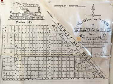
Document, photocopy of Plan of Beaumaris 1853, c1960
Beaumaris includes two early estates in the parish of Moorabbin developed by Josiah Holloway from 1852. Named Beaumaris Town and Beaumaris Estate (after the pastoral run in the area and ultimately after Beaumaris in Wales), the lots comprising them were marketed by Mr Holloway's suggesting that the railway was imminent and a canal would be built. The township developed slowly, a Post Office opened on 1 March 1868, but was replaced next month by Gipsy Village office (now Sandringham) In 1862 Beaumaris was one of the early settler communities within the boundaries of the Moorabbin District Roads Board , the region’s first local government authority. Beaumaris is a suburb in Melbourne, Victoria, Australia, 19 km south-east from Melbourne's central business district. .Since the Amalgamation of Councils 1994 the local government area is the City of Bayside which includes Brighton. A Photocopy of the Plan of Beaumaris 1853 A3moorabbin, county of bourke, brighton, beaumaris, pioneers, early settlers. market gardeners, cheltenham, king. john, holloway josiah, whorral charles, arthur’s seat road, nepean highway, morabbin district roads board, sandringham, mordialloc, mentone -
 Kiewa Valley Historical Society
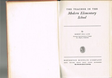
Book - Reference Teaching Infants, The Teacher in the Modern Elementary School, 1941
This teacher's aid publication was used by the teachers in the The Bogong Primary School from 1941 and also the Mount Beauty Primary School from its establishment in 1947. Both had most of their pupils recruited from SEC(Victoria) Hydro Electricity Scheme employees working for a limited time scale. Rural based children benefited greatly by the decision by the SEC to provide these facilities for their worker's families. This bypass of the "typical rural provisions" offered to other schools, by the Victorian Department of Education was a bonus to the Kiewa Valley educational community. These schools had a higher level of facilities available to them than other "typical" rural schools. Treasured facilities such as a comprehensive library, movie projector, tape recorder and public address system placed these two schools at the level of the Greater Public School of city or the larger towns rather than the small rural schools in Victoria.This item was used in Mount Beauty Primary School as part of a teacher's curriculum. The fact that it is in a rural area, in an enclosed SEC construction worker's village in the Kiewa Valley did present a slightly different learning atmosphere than in the larger towns and cities. The majority of parents within the Kiewa Valley, had a slight resentment of the "high and mighty" attitude of city dwellers with a "plum in their mouths" and the effectiveness that city bred teachers had to achieve was to overcome these ingrained mores. The majority of students at this primary school had parents who were working for (the closed "village" of the SEC Hydro Electricity Scheme. In the 1940s this school would have children from multi-cultural backgrounds as many of the parents were recruited as labourers or with European technical backgrounds. In the book,the black and white photographs detailing the classroom sizes and configurations point to larger classes and slightly different teaching methods than that which existed in Australia. This teacher's aid book presents the Australian rural teachers with an advanced American approach to teaching methods. These methods were based on the then modern "group" psychological teachings and were a good guide in the development of a more effective and progressive teaching platform. The one thing that it did not address was the easy going Australian psyche of "she'll be right mate" of the Australia rural community. The socio-economic identity of the Kiewa Valley rural community was not that of the typical city community (American) and this was a challenge for city based and trained teachers. The principles that the book presents is not constrained by the date of publication or its time of use (1954).This hard cardboard covered book is sleeveless but bound by a red cloth glued onto a thick cardboard base. It has the title printed in gold script on the spine with horizontal and fifteen black horizontal lines at the top and bottom. The front cover has the title printed in gold coloured letters (the first and last words are in freehand script style)On the spine and front cover is printed "The TEACHER IN THE MODERN ELEMENTARY School" school organisation, developmental stages of children, subliminal classroom mental and physical stimulation, usa 1940s teacher aids. -
 Bayside Gallery - Bayside City Council Art & Heritage Collection
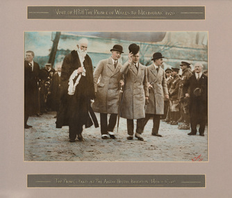
Photograph - hand tinted gelatin silver photograph, H. Singer, The Prince and party at The Anzac Hostel, Brighton, 1920
In 1920 the Prince of Wales embarked on a journey to Australia on behalf of his father, King George V. While the visit was intended to strengthen the relationship between Australia and the Empire, the main objective was to offer thanks to the Australian men and women for the sacrifices and contributions that they had made during World War I. The Royal Tour began in April 1920 and covered 110 cities and towns across the country. The Prince spent eleven days in New South Wales, nine days in Victoria, four days in Tasmania, eleven days in Western Australia, six days in South Australia and eight days in Queensland. On Saturday 5 June 1920, following a morning at the races in Flemington, the Prince spent the afternoon at ANZAC Hostel in Brighton, where he chatted to wounded soldiers and, according to the newspaper reports at the time, "won the hearts of all present."prince of wales, his royal highness, hrh, royal tour, anzac hostel, brighton, mayor, cr. thomas wilson, soldiers, diggers, crowd, north road, kamesborough, bayside -
 Ballarat Heritage Services
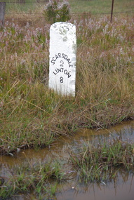
Photograph, LJ Gervasoni, Scarsdale/Linton Milepost (or Milestone), 20-06/2009
Stone mileposts dating from the 1870s are found on the Glenelg Highway. Stone and iron mileposts are now a rarity, and have remanining markers have become a tourist attaction in many smaller towns with remnant markers. The stone mileposts on the Glenelg Highway are listed on the Victorian Heritage Reigister as being significant to the State of Victoria. Their primary purpose is to inform the travelling public of distances and directions to various destinations. The stone milepost in the current City of Ballarat are located on the Glenelg Highway (between Ballarat and Scarsdale), Smythes Creek and Delacombe, and have been registered by Heritage Victoria, (HO155) Other stone mileposts are located In Golden Plains Shire at Smythesdale (Victorian Heritage Register H1701) Metrication in Australia caused former mile markers to be gradually replaced with 10 km markers on highways and country roads, which are referred to as "kilometre plates".Colour photograph of a stone mile post on between Ballarat, Scarsdale and Lintonmilepost, mile post, scarsdale, linton, ballarat, mile marker, stone milepost, milestone -
 City of Greater Bendigo - Civic Collection
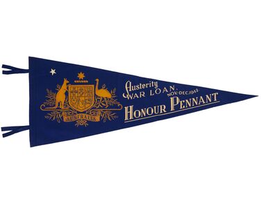
Award - Set of Twenty Two Security Loan Honour Pennants, Commonwealth of Australia, c 1946 - 1963
Australia, like many countries involved in both the First and Second World Wars realised that they would need more funds to resource their campaigns, so war loan programs were developed. These programs encouraged the population to purchase government war bonds which would be repaid with interest at a later time while immediately assisting the war effort. Post WW2 the government continued to encourage citizens to save money in an attempt to curb inflation. Security loans formed part of this countries economic program from the 1940's onwards. Districts were allocated a quota for which they encouraged citizens to subscribe and pennants were awarded for the highest per capita payment amongst the town population. In 1946 Bendigo was the first country city in Australia to record a quota success for the Second Security Loan, raising £260,480 from 1953 subscribers. Triangle felt screen printed pennants, various colours with two ties along left side. Pennants range in date from 1942 until 1963. 253.1 Blue felt triangle pennant with two ties on long side. Gold printed Commonwealth of Australia Coat of Arms, cream printed text and one star top left of crest. Dimensions: 1010mm W x 355 H x 3mm 253.2 Blue felt triangle pennant with two ties on long side. Gold printed Commonwealth of Australia Coat of Arms, printed cream, red and blue coloured text . One cream coloured printed star top left of crest. Dimensions: 985 W x 367 H x 3mm 253.3 Blue felt triangle pennant with two ties on long side. Gold printed Commonwealth of Australia Coat of Arms, printed cream, red and blue coloured text . One cream coloured printed star top left of crest. Dimensions: 955W x 355 H x 3mm 253.4 Green felt triangle pennant with two ties on long side. Gold printed Commonwealth of Australia Coat of Arms, printed cream, red and green coloured text . One cream coloured printed star top left of crest. Dimensions: 970 W x 367 H x 3mm 253.5 Green felt triangle pennant with two ties on long side. Gold printed Commonwealth of Australia Coat of Arms, printed yellow, pink and green coloured text . Two cream coloured printed stars top left of crest. Dimensions: 975 W x 370 H x 3mm 253.6 Red felt triangle pennant with two ties on long side and remnants of bronze ribbon stapled to long side. Yellow printed Commonwealth of Australia Coat of Arms, printed white, yellow, cream and light blue text . Two cream coloured printed stars top left of crest. One light blue star centre right. Dimensions: 1055 W x 355 H x 3mm 253.7 Light blue felt triangle pennant with two ties on long side and bronze ribbon stapled to long side. Yellow printed Commonwealth of Australia Coat of Arms, printed red, white and dark blue text . One cream coloured printed star top left of crest. Dimensions: 966 W x 355 H x 3mm 253.8 Green felt triangle pennant with two ties on long side. Yellow printed Commonwealth of Australia Coat of Arms, printed pink, white and yellow text . One cream coloured printed star top left of crest. Dimensions: 970 W x 350 H x 3mm 253.9 Red felt triangle pennant with two ties on long side and remnants of bronze ribbon stapled to long side. Yellow, blue, red and cream printed Commonwealth of Australia Coat of Arms with printed black, white and light blue text. Additional text on long side of pennant adjacent to ties. Three cream coloured printed stars top left of crest. Dimensions: 965 W x 350 H x 3mm 253.10 Blue felt triangle pennant with two ties on long side and remnants of bronze ribbon attached to ties. Yellow printed Commonwealth of Australia Coat of Arms with printed dark blue, cream and red text. Two cream coloured printed stars top left of crest. Dimensions: 930 W x 365 H x 3mm 253.11 Red felt triangle pennant with two ties on long side. Yellow, blue, red and cream printed Commonwealth of Australia Coat of Arms with light blue and cream text. Three cream coloured printed stars top left of crest. Dimensions: 1025 W x 355H x 2mm 253.12 Dark blue felt triangle pennant with two ties on long side. Yellow printed Commonwealth of Australia Coat of Arms with light blue text. Additional text on long side of pennant adjacent to ties. One cream coloured printed star top left of crest. Dimensions: 920 W x 338 H x 3mm 253.13 Dark blue felt triangle pennant with two ties on long side. Yellow printed Commonwealth of Australia Coat of Arms with maroon text. One cream coloured printed star top left of crest. Dimensions: 930 W x 360 H x 3mm 253.14 Dark blue felt triangle pennant with two ties on long side. Yellow printed Commonwealth of Australia Coat of Arms with yellow text. Two cream coloured printed stars top left of crest. Dimensions 910 W x 345 H x 3mm 253.15 Dark blue felt triangle pennant with two ties on long side. Yellow printed Commonwealth of Australia Coat of Arms with light blue text. one cream coloured printed star top left of crest. Dimensions: 905 W x 345 H x 3mm. 253.16 Dark blue felt triangle pennant with two ties on long side. Yellow printed Commonwealth of Australia Coat of Arms with brown text. One cream coloured printed star top left of crest. Dimensions: 930 W x 360 H x 3mm 253.17 Dark blue felt triangle pennant with two ties on long side. Yellow printed Commonwealth of Australia Coat of Arms with blue text. One cream coloured printed star top left of crest. Dimensions: 915 W x 350 H x 3mm 253.18 Dark blue felt triangle pennant with two ties on long side. Yellow printed Commonwealth of Australia Coat of Arms with blue text. One cream coloured printed star top left of crest. Dimensions: 950 W x 355 H x 3mm 253.19 Dark blue felt triangle pennant with two ties on long side. Yellow printed Commonwealth of Australia Coat of Arms with blue text. One cream coloured printed star top left of crest. Dimensions: 950 W x 355 H x 3mm 253.20 Dark blue felt triangle pennant with two ties on long side. Yellow printed Commonwealth of Australia Coat of Arms with cream text. One cream coloured printed star top left of crest. Dimensions: 965 W x 360 H x 3mm 253.21 Dark blue felt triangle pennant with two ties on long side. Yellow printed Commonwealth of Australia Coat of Arms with blue text. One cream coloured printed star top left of crest. Dimensions: 950 W x 365 H x 3mm 253.22 Dark blue felt triangle pennant with two ties on long side. Yellow printed Commonwealth of Australia Coat of Arms with cream text. One cream coloured printed star top left of crest. Dimensions: 940 W x 365 H x 3mm 253.1 Austerity /War Loan / Nov - Dec 1942 / Honour Pennant 253.2 Second / Security Loan / Oct - Nov 1946 / Honour Pennant 253.3 Third / Security Loan / April - May 1947 / Honour Pennant 253.4 Fourth / Security Loan / Oct - Nov 1947 / Honour Pennant 253.5 Fifth / Security Loan / April - May 1948 / Honour Pennant 253.6 Seventh/ Security Loan / March – April 1949 / Bendigo 253.7 Eighth / Security Loan / Sept – Oct 1949 / Honour Pennant 253.8 Ninth / Security Loan / March 1950 / Honour Pennant 253.9 Special Award / Tenth / Security Loan / August 1950 / City of Bendigo 253.10 Eleventh/ Security Loan / Nov-Dec 1950 / Honour Pennant 253.11 Special Award / 12th Security Loan / may- June 1951 / City of Bendigo 253.12 Sixteenth / Security Loan / Nov-Dec 1952 / Honour Pennant 253.13 Eighteenth / Security Loan / Sept – Oct 1953 / Honour Pennant 253.14 Nineteenth / Security Loan / March 1954 / Honour Pennant 253.15 Commonwealth / Security Loan / August 1954 / Honour Pennant 253.16 Commonwealth / Security Loan / august 1954 / Honour Pennant 253.17 Commonwealth / Security Loan / August 1956 / Honour Pennant 253.18 Commonwealth / Security Loan / August 1957 / Honour Pennant 253.19 Commonwealth / Security Loan / May 1960/ Honour Pennant 253.20 Commonwealth / Security Loan / September 1960/ Honour Pennant 253.21 Commonwealth / Security Loan / February March 1961/ Honour Pennant 253.22 Commonwealth / Security Loan / February 1963 / Honour Pennant commonwealth loan scheme, city of greater bendigo awards -
 Glen Eira Historical Society
Letter - Gardenvale Road, 78, Gardenvale
This file contains six items. Five items of typed correspondence concerning application to build four double-storey dwellings at 78 Gardenvale Road. Correspondence between City of Glen Eira and residents R.A. and P. Darke from 08/12/2008 to 20/03/2009, and Paul Siedle. Typed copy of resident Jonathon Breedon’s objections to the proposed plan. Copy of original plans for the dwellings dated 12/09/2008. Copy of amended plans for the four dwellings dated November 2008. Typed letter dated 20/03/2009 from Glen Eira Senior Town Planner to Richard and Peta Darke notifying of council’s decision of intention to grant a planning permit for the dwellings. Typed five page notice of decision to grant a planning permit for the four dwellings dated 20/03/09. Included is a one page description of the appeal process.gardenvale road, magnolia road, gardenvale, city of glen eira, city hall, glen eira road, hawthorn road, lloloma receptions, caulfield south, darke peta, darke richard, elster avenue, elsternwick, torres ron, kokkinos stella, glen eira city council, statutory planning department, breedon jonathon, lantana road, peter l. brown architects pty ltd., glen eira planning scheme, elsternwick library, bentleigh library, carnegie library, caulfield library, staniland grove, jasper road, shepparson avenue, bentleigh, carnegie, caulfield, siedle paul, townhouses, town planning, plans, aerial photographs, architectural drawings, architects, brick houses -
 Melbourne Tram Museum
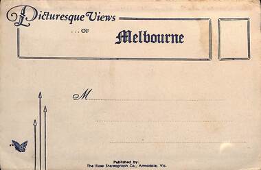
Postcard - Folder, Rose Stereograph Co, "Picturesque Views of Melbourne", mid 1930s
Comprises 12 photos of Melbourne, mid to late 1930s. Produced by Rose Stereograph of Armadale. 1 - Botanical Gardens and Government House 2 - The MacRobertson Fountain with Shrine in the background and Government house in the distance - no advanced trees. See reference - completed 1934. 3 - Flinders Street Railway Station with a W2 class tram in the view 4 - St Kilda Road Melbourne 5 - Collins St with the Regent Theatre, National Mutual and the Town Hall 6 - Princes Bridge and the City Skyline 7 - The Conservatory Fitzroy Gardens 8 - The Cathedral Corner - St Pauls and Gas & Fuel building 9 - St Kilda Road with the Shine of Remembrance in the distance 10 - Looking across Princes Bridge to St Kilda Road - is Prince Henry Hosptial there? 11 - Parliament House 12 - Captain Cook's Cottage, Fitzroy Gardens - which dates from 1934. Yields information about Melbourne city views and new attractions mid 1930s. Paper envelope folder with 6 photos on each side of a foldout section titled "Picturesque Views of Melbourne" melbourne, post cars, photo folders -
Bendigo Historical Society Inc.
Document - MUSIC ADVANCMENT SOCIETY OF BENDIGO, SECOND CONCERT 1956, TOWN HALL, 11 March, 1959
a/ Music Advancement Society of Bendigo, Second Concert 1956, Town Hall, Bendigo. The Pascal String Quartet. (Official String Quartet of the French National Radio). Violin: Jacques Dumont, Maurice Crut, Walter Gerhardt. 'Cello: Robert Salles. Monday, 23rd April, 1956. 8.15pm. Hon. Secs. Madge Edgar, Mary Stanistreet. Programme. Advertisments: Allan's, Allan's Walk, Bendigo. Frank J. Every & Sons, Hargreaves Street, Bendigo. Phone 874. Edgars', 293 Hargreaves St., Bendigo. Phone 238. b/ Music Advancement Society of Bendigo, Wednesday, 10th April, 1957. Darrenin String Quartet. Hon Secs.: Madge Edgar, Mary Stanistreet. Programme. Advertisements: Frank J Every & Sons. Hargreaves St., Bendigo, Ph. 874. A C Hampton, Mitchell St., Bendigo, Ph. 241. Edgars Autorised Newsagency. 293 Hargreaves St. Bendigo, Ph. 238. c/ Music Advancement Society of Bendigo, Presents the Third Concert 1957 series. Brian Hansford, Baritone, Graeme Buchanan, Piano. Town Hall, Bendigo. Wednesday, 25th September, 1957, 8.15 pm. Hon. Secs.: Madge Edgar, Mary Stanistreet. Advertising Phillips and Deutsche Recordings available at Allan's, Allan's Walk, Bendigo. A C Hampton, Newsagent stationer, Mitchell Street, Bendigo. Ph 241. Edgars' Authorised Newsagency. 293 Hargreaves St., Bendigo. Telephone 238. d/ Music Advancement Society of Bendigo Presents the First Concert 1959. Presenting Nancy Weir, Pianist. City Hall, Bendigo. Wednesday, 11th March, 1959. Hon. Secs. : Madge Edgar, Mary Stanistreet. Advertisements: Allan's A C Hampton, Edgars'. Pinned inside newspaper article titled 'Pianist Held Audience. Nancy Weir enthralled her bendigo Audience in the City Hall when she opened the 1959 concert series for the Music Advancement Society. Miss Weirs' 7th visit to Bendigo, 5 of them under the auspices of the MASB. Her unaffected style, her great reserves of strength for one so diminutive . . . Name of newspaper not included.Bolton Bros. Pty Ltd., Printers, Bendigoprogram, theatre, music advancement society of bendig, a/ music advancement society of bendigo, second concert 1956, town hall, bendigo. the pascal string quartet. (official string quartet of the french national radio). violin: jacques dumont, maurice crut, walter gerhardt. 'cello: robert salles. april, 1956. stanistreet. programme. advertisments: allan's. frank j. every & sons. b/ 1957. darrenin string quartet. advertisements: a c hampton. edgars autorised newsagency. c/ presents the third concert 1957 series. brian hansford, baritone, graeme buchanan, piano. 1957. advertising: phillips and deutsche recordings available. a c hampton, newsagent stationer. d/ first concert 1959. nancy weir, pianist. 11th march, 1959.. advertisements: edgars'. pinned inside newspaper article titled 'pianist held audience. nancy weir enthralled her bendigo audience in the city hall when she opened the 1959 concert series for the music advancement society. miss weirs' 7th visit to bendigo, 5 of them under the auspices of the masb -
Ringwood and District Historical Society
Plastic packet, PTC - Maroondah City Council, Public Transport Commission, Ringwood Railway Station Development Study, Interchange Upgrade, Community Workshops - various printed documents 1995-2013, 1995 to 2013
The urban consulting group commissioned Maroondah City Council and the Public Transport Feasibility Study, Ringwood Railway Station to be upgraded October 1995Various printed documents relating to PTC (Public Transport Commission), Maroondah City Council, Department of Transport - Ringwood Railway Station Redevelopment Study October 1995, Ringwood Station Bus interchange upgrade, designing new look Ringwood Station. Workshops were held for the community. +Additional Keywords: Ringwood Station Bus Interchange upgrade feed back sheet October 2011 / Ringwood Station Precinct Redevelopment Workshop held 26 July 2011 / Ringwood Station and bus upgrade December 2011 / Ringwood Town Centre South Project / Precinct Plans Planning Report. / Ringwood Town Centre Draft Report November 2000 / Ringwood Activities Community Newsletter August 2011 - Ringwood Station Update / State Government to sell Central Ringwood Railway land - Herald Sun 30 December 2013 / Ringwood Town Centre Precinct 4 Station Superblock for Railway Station July 2009 / Media release $66m station 15 April 2015 / Ringwood Station and Interchange Upgrade, Wednesday 27 August 2014 / Lifts left off upgrade plan - Leader Community Paper, 10 December 2013 / How to submit your feedback - Ringwood Station Precinct proposed concept, December 2011 / Designing a new look Ringwood Station workshop handout / State Government announces $66 million redevelopment of Ringwood Train Station, Herald Sun 6 June 2013 / Ringwood Station and bus interchange upgrade project update July 2012 / Set Concept design plans of $66 million Ringwood Railway Station over the years / Set photos of Ringwood Station taken between 2004 to 2005 / A3 drawing - Plan of Ringwood Station / A3 drawing - Ringwood Station proposed layout / A3 drawing - Old Station, Ringwood / A3 drawing - Proposed plan 2011 / A4 drawing - Final plan of Ringwood Station 2014 / A4 drawing - Proposed plan 2010 Ringwood Railway Station / A3 drawing - Proposed plan Ringwood Station with bridge across Maroondah Highway -
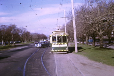 Ballarat Tramway Museum
Photograph - Digital image Set of 10, Tony Smith, 1971
Yields information about Ballarat Tramways and trams prior to the closure of the tramway system.Set of 10 digital images of Ballarat trams prior to closure, scanned from original slides by Tony Smith, 1971 prior to closure of the system. .1 - 13 at the Parker St loop, Sturt St west waiting for another tram to arrive - Mercedes Benz car pull out around the stationary tramcar. .2 - 13 and another single trucker at the City terminus, north side of Sturt St. Note the conductor in the distance with a point bar about to hop onto the tram turning into Lydiard St North. Has the Post Office in the background. .3 - 26 arriving at the City stop, with the Mechanics Institute and Cooks Provide Hotel in the background. Tram has destination of Gardens via Drummond St North. .4 - 33 and 12 in Lydiard St Nth at Sturt St. 33 (Lydiard St Nth), 12 (Sebastopol). Has the post office and other buildings in the background .5 - 12 and 26 at city stop, south side with Town Hall and Myers in the background. 12 has destination of Sebastopol. .6 - 12 at intersection of Drummond St and Sturt St with Mobil petrol station in background and ad for Marshall batteries. Has the tram stop sign on the left hand side. Tram has destination of Sebastopol and a Twin Lakes sign. .7 - 30 northbound in Drummond St south at Sturt St about to turn into Sturt St. Has destination of Lydiard St Nth. Has the Southern Cross hotel in the background. .8 - 31 turning from Drummond St North into Sturt St, en route to Victoria St with the Shell service station in the background. Hospital Corner. Tram has roof advertisements for Johnnie Walker whisky. .9 - 30 and 31 (from above photos) in Sturt St. .10 - Tony Smith standing on the doorstep of 26 at Mt Pleasant terminus. Has the store in the background with The Sun and Robur tea adverts. trams, tramways, parker st loop, sturt st west, sturt st, conductors, drummond st, hospital corner, mt pleasant, tram 13, tram 26, tram 12, tram 30, tram 33 -
 Kew Historical Society Inc
Plan, Melbourne & Metropolitan Board of Works : Borough of Kew : Detail Plan No.1588, 1904
The Melbourne and Metropolitan Board of Works (MMBW) plans were produced from the 1890s to the 1950s. They were crucial to the design and development of Melbourne's sewerage and drainage system. The plans, at a scale of 40 feet to 1 inch (1:480), provide a detailed historical record of Melbourne streetscapes and environmental features. Each plan covers one or two street blocks (roughly six streets), showing details of buildings, including garden layouts and ownership boundaries, and features such as laneways, drains, bridges, parks, municipal boundaries and other prominent landmarks as they existed at the time each plan was produced. (Source: State Library of Victoria)This plan forms part of a large group of MMBW plans and maps that was donated to the Society by the Mr Poulter, City Engineer of the City of Kew in 1989. Within this collection, thirty-five hand-coloured plans, backed with linen, are of statewide significance as they include annotations that provide details of construction materials used in buildings in the first decade of the 20th century as well as additional information about land ownership and usage. The copies in the Public Record Office Victoria and the State Library of Victoria are monochrome versions which do not denote building materials so that the maps in this collection are invaluable and unique tools for researchers and heritage consultants. A number of the plans are not held in the collection of the State Library of Victoria so they have the additional attribute of rarity.Original survey plan, issued by the MMBW to a contractor with responsibility for constructing sewers in the area identified on the plan within the Borough of Kew. The plan was at some stage hand-coloured, possibly by the contractor, but more likely by officers working in the Engineering Department of the Borough and later Town, then City of Kew. The hand-coloured sections of buildings on the plan were used to denote masonry or brick constructions (pink), weatherboard constructions (yellow), and public buildings (grey). This plan shows the original configuration of the Kew Post Office, Court House and Police Station, which had opened in 1888. This configuration was to essentially remain until the purchase of the Court House and Police Station by the City of Boroondara in 2007 and its subsequent renovation. Interestingly, the MMBW surveyors incorrectly labelled parts of the complex. In the triangle in front of the Post Office, before the erection of the Kew Cenotaph in 1925, was located a lawn and the Queen Victoria Jubilee Fountain. While many of the shops on the south side of High street had been constructed by 1903 a number of sites were still used as vegetable gardens. Further along High Street, on the corner of Charles Street, the Salvation Army Barracks can be seen on the plan. These Barracks predate the later Citadel and ‘Young People’s Hall’ that were opened in 1919. At 22 Charles Street can be seen the house of James Venn Morgan. Hailed as the ‘father of Kew’, Morgan arrived in Melbourne in 1840. He was first engaged as a bookmaker, but a fortunate venture on the goldfields enabled him to purchase land in Kew. He conducted a market garden and dairy in Kew for many years.melbourne and metropolitan board of works, detail plans, maps - borough of kew, mmbw 1588, cartography -
 Ballarat Tramway Museum
Photograph - Digital image Set of 10, George Coop, 1968 - 1970
Yields information about the tram operations and the landscape views of the Sturt St median strip.Ten (10) Digital images taken by George Coop during the period 1968 - 1970, of SEC trams in Sturt St, between the City and Pleasant Streets. .1 - Tram 26 climbing the Sturt St hill to Lydiard St, with the Cook's Private Hotel, the Commonwealth Bank and the National Mutual Life building in the background. Photo taken from the Titanic Bandstand. .2 - Tram 40 Sturt St, enough to Lydiard St North just before Raglan St. Has a lady passenger by the tram stop. .3 - Tram 30 - Sturt St north side, near Armstrong St, - has a blue framing line around the photograph. .4 - Tram 39, Sturt St, near Doveton St, shows the rotunda in the median strip. .5 - Tram 18, with median step in view. .6 - Tram 31, with two Johnnie Walker whiskey roof adverts, outside the National Mutual Life building with the Alan Bros Jewellers and Golden Star Chinese Cafe in the view. .7 - Tram 31, Sturt St south side with Town Hall and the Golden City Hotel in the view. Tram has destination of Gardens via Drummond North. .8 - Tram 41 - ditto - going to Sebastopol. .9 - Tram 13, south side, Gardens via Sturt West, about , near Ripon St, with the Ampol service station in the background and about to pick up a lady passenger .10 - Tram 17, near Doveton St. Has a Twin Lakes sign and a Wilkinson Sword Razor Bladese roof advert. trams, tramways, sturt st, raglan st, passengers, doveton st, tram 26, tram 40, tram 30, tram 39, tram 18, tram 31, tram 41, tram 13, tram 17 -
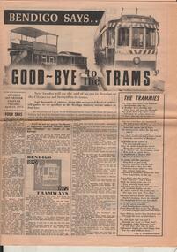 Bendigo Historical Society Inc.
Document - BASIL MILLER COLLECTION: BENDIGO SAYS GOOD-BYE TO THE TRAMS, c1972
13 April 1972. Bendigo Says Good-bye to the Trams. A1 sheet - double sided. Tramway history 1890 - 1972, 2 copies. At the stroke of 5 pm from Eaglehawk Town Hall clock 82 years of history will end as the last tram makes its sentimental journey to the city, while at the Bendigo Cemetery - the Quarry Hill line terminus - another tram will be leaving for its last resting place. Other articles include: Four Eras, of trams. The Trammies, covering Ballarat, Geelong in the form of a poem. 1927 and all that, by Basil Miller, remembering his 45 years of service with the trams. How it all started, The twin communities of Sandhurst and Eaglehawk were relatively early in considering the possibility of operating street tramways within their boundaries. Cabs, Battery Cars, Construction, Strikes, Bendigo 1890 to 1972 - Tramways. Man and his Mates, continued from previous page, Explosion, Touchy Task, A Quickey, Horrors. Electric in 1903, There was excitement galore in the City during April, 1903 - and the Advertiser recorded the progress of the new-fangled electric machine. One man's Memories, Tough times, humour, tragedy and comradeship - they all came flooding back as former Bendigo tramway-man Tom Griffiths recently turned the clock back. Keb Sir Keb Sir? 'Keg sir? Tram off the line,' was the call of the cabbies when a train pulled in at the Bendigo railway station. Altered Shopping Trend, With advent of the electric tram in Bendigo came change in shopping habits.organization, business, bendigo trams, bendigo advertiser -
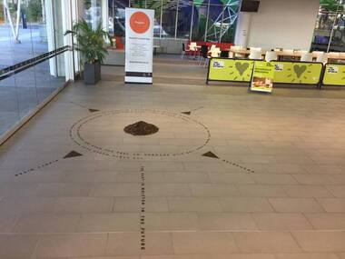 Greensborough Historical Society
Photograph - Digital Image, Art at WaterMarc, July 2017, 22/07/2017
Photographs of an art installation by Jessie Stanley at WaterMarc Greensborough on 22/07/2017. From Jessie Stanley's FaceBook page :Dust to Dust is complete... It's an ephemeral site-specific work about how the Melbourne suburb of Greensborough has transformed over time. This area's exceptionally fertile soil [used by] by white settlers for farms, market gardens and orchards reshaped the Wurundjeri's traditional lands - and today the private sale and division of these farms informs the streetscape and town plan. With soil sourced locally this work reveals some of the area’s history - the text running around the perimeter was written by former resident Val Wilson, a snippet of her recollections of growing up in the area in the 1950s. The arrows and text act like a compass to orientate this site with greater Melbourne. On display in the lobby of Banyule Council until chance, time (or a broom) sweeps it away, Many thanks to Banyule City Council, Greensborough Historical Society and Valerie Wilson. "An artistic representation of Greensborough's history.Digital photographs of art installation.jessie stanley, watermarc, greensborough historical society, banyule council -
 Kiewa Valley Historical Society
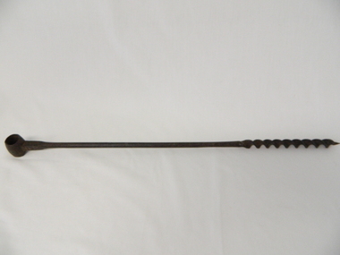
Drill Auger, Circa early 1900s
This item wasused before diesel, electric and battery drilling apparatus were used by farmers, and other trades requiring a portable yet reliable method of drilling holes. As this item is a 3/4 inch hole drill it would be suitable for fencing and providing holes for structural studs. As with all outdoor farm equipment, man power was required (be it the farmer or farm hands). Fitness of the operator was at a high standard but protective gloves were not highly thought of as it was before occupational, health and safety regulations became mandatory over all manual handling activities, be they on rural properties or town/city factories. This period was one where the male ego was at its pinnacle i.e. the harder the tasks the more of a man was required. Hard manual work was not only the "way to go" but also a necessity. Evolution of cheap portable electric/battery powered tools opened up a more efficient method available, especially to those with less muscle strength. This item personifies the rugged environment of the rural workplace. The Kiewa Valley with its main emphasis on farming and grazing provided ample opportunity to use this construction implement. The manufacturer being a Scottish tool company is very significant in the era when this hole maker was in high demand. British steel products were of high grade and had a good record of reliability. The reliability of any tool was a solid factor for farmers and tradesmen in this semi-isolated region (Circa early 1900s) within the Kiewa Valley and its regional area. This factor,although not as crucial, post 1960s, when Asian manufacturers entered the market place and produced cheaper tools and transportation and supplies was more frequent and reliable, the need for the more expensive British made tools diminished considerably. After the influx of tradesmen from war torn Europe (post 1945) and the increased availability of tradesmen in the Kiewa Valley and its region the price of tools was and still is not as crucial and the cost of all required tools has become a minimal part of the equation. It is only with the emerging younger trades person, farmer and grazier, who have more, "one eye on production costs" and no "old ties to the motherland" inert mind set that quality tools such as this auger and other hand tools "must be made to last a life time" is no longer part of the modern work environment.This cast iron, hand operated Auger has a short barrel shaped cylinder at one end (known as the "Eye") and at the other end a Helical screw blade (screws the cutting edge into wooden material, thereby creating a hole 3/4 inch diameter in the wood) . The barrel section at the top permits a metal or wooden leverage plank to be inserted. The main rod has a 180mm long cutting/screw blade running from the bottom up towards the "eye" end. From the end of the screw blade to the handle is 380mm and cylindrical, but this changes at 550mm from the "eye" end to a 14mm x 10mm rectangular shape shaft.This shaft end is welded to the "Eye".On the shaft below the "eye" is stamped " MATHESON GLASGOW" on the front side and a spade (cards) symbol on the back.auger, hand drill, fencing, tool, rural trades, brace & bit -
 Kiewa Valley Historical Society
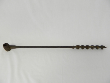
Drill Auger, Circa early 1900's
This item was before diesel, electric and battery drilling apparatus were used by farmers, and other trades requiring a portable yet reliable method of drilling holes. As this item is a 3/4 inch hole drill it would be suitable for fencing and providing holes for structural studs. As with all outdoor farm equipment, man power was required (be it the farmer or farm hands). Fitness of the operator was at a high standard but protective gloves were not highly thought of as it was before occupational, health and safety regulations became mandatory over all manual handling activities, be they on rural properties or town/city factories. This period was one where the male ego was at its pinnacle i.e. the harder the tasks the more of a man was required. Hard manual work was not only the "way to go" but also a necessity. Evolution of cheap portable electric/battery powered tools opened up a more efficient method available, especially to those with less muscle strength.This item personifies the rugged environment of the rural workplace. The Kiewa Valley with its main emphasis on farming and grazing provided ample opportunity to use this construction implement. The manufacturer being a Scottish tool company is very significant in the era when this hole maker was in high demand. British steel products were of high grade and had a good record of reliability. The reliability of any tool was a solid factor for farmers and tradesmen in this semi-isolated region (Circa early 1900s) of the Kiewa Valley and its regional area. This factor,although not as crucial, post 1960s, when Asian manufacturers entered the market place and produced cheaper tools and transportation and supplies was more frequent and reliable, the need for the more expensive British made tools diminished considerably. After the influx of tradesmen from war torn Europe (post 1945) and the increased availability of tradesmen in the Kiewa Valley and its region the price of tools is not as crucial and the cost of all required tools has become a minimal part of the equation. It is only with the emerging younger trades person, farmer and grazier, who have more, "one eye on production costs" and no "old ties to the motherland" inert mind set that quality tools such as this auger and other hand tools "must be made to last a life time" is no longer part of the modern work environment.This cast iron hand operated drill, has a short barrel-shaped cylinder, known as "the eye" welded across the main rod and is 30mm in circumference. It also has a hole drilled to allow a screw to be fastened onto the hand stock ( not available).The main rod is solid for 400mm and then has been flattened and coiled (Helical screw blade) for another 200mm. At the end of the larger screw blade there is a smaller gauged starter blade with a pointer thread 15mm long. This Auger produces a 1/8th inch hole (metric measurement not used at time of manufacture) See KVHS 0469 for 3/4 inch hole and KVHS 0471 for another 1/8th inch hole.A number 5 stamped on the flat sideauger, hand drill, fencing, tool, rural trades, brace & bit -
 Kiewa Valley Historical Society
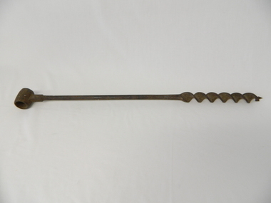
Drill Auger, Circa early 1900's
This item was before diesel, electric and battery drilling apparatus were used by farmers, and other trades requiring a portable yet reliable method of drilling holes. As this item is a 3/4 inch hole drill it would be suitable for fencing and providing holes for structural studs. As with all outdoor farm equipment, man power was required (be it the farmer or farm hands). Fitness of the operator was at a high standard but protective gloves were not highly thought of as it was before occupational, health and safety regulations became mandatory over all manual handling activities, be they on rural properties or town/city factories. This period was one where the male ego was at its pinnacle i.e. the harder the tasks the more of a man was required. Hard manual work was not only the "way to go" but also a necessity. Evolution of cheap portable electric/battery powered tools opened up a more efficient method available, especially to those with less muscle strength.This item personifies the rugged environment of the rural workplace. The Kiewa Valley with its main emphasis on farming and grazing provided ample opportunity to use this construction implement. The manufacturer being a Scottish tool company is very significant in the era when this hole maker was in high demand. British steel products were of high grade and had a good record of reliability. The reliability of any tool was a solid factor for farmers and tradesmen in this semi-isolated region (Circa early 1900s) of the Kiewa Valley and its regional area. This factor,although not as crucial, post 1960s, when Asian manufacturers entered the market place and produced cheaper tools and transportation and supplies was more frequent and reliable, the need for the more expensive British made tools diminished considerably. After the influx of tradesmen from war torn Europe (post 1945) and the increased availability of tradesmen in the Kiewa Valley and its region the price of tools is not as crucial and the cost of all required tools has become a minimal part of the equation. It is only with the emerging younger trades person, farmer and grazier, who have more, "one eye on production costs" and no "old ties to the motherland" inert mind set that quality tools such as this auger and other hand tools "must be made to last a life time" is no longer part of the modern work environment.This cast iron hand operated drill, has a short barrel-shaped cylinder, known as "the eye" welded across the main rod and is 30mm in circumference. It also has a hole drilled to allow a screw to be fastened onto the hand stock ( not available).The main rod is solid for 400mm and then has been flattened and coiled (Helical screw blade) for another 200mm. At the end of the larger screw blade there is a smaller gauged starter blade with a pointer thread 15mm long. This Auger produces a 1/8th inch hole (metric measurement not used at time of manufacture) See KVHS 0469 for 3/4 inch hole and KVHS 0470 for another 1/8th inch hole.auger, hand drill, fencing, tool, rural trades, brace & bit -
 Kiewa Valley Historical Society
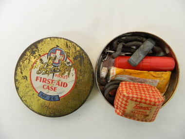
Functional object - Pocket First Aid, Circa mid 1900s
This pocket First Aid kit is small and compact which became available to those venturing out in the outback and required an easily managed first aid kit. It was manufactured in the mid 1900s well before vinyl and or plastic pouches or bags where used. It was in an era where valuable items were stored in durable containers due to the harsh and rugged conditions of the Australian bush. Cheaper and less durable containers from Asian manufacturers had been kept out by the heavy Tariff imposed on their goods. This changed in the 1980's when the Tariff Board was dismantled by a then Labour Government. The Australian manufacturing industry was severely reduced by the Influx of cheaper goods. This item was made by an Australian company when the motto "true blue" was the catch cry for quality Australian made goods. This was in the period where the isolation of many rural communities required the basic first aid kits to be of a tougher quality than those offered in large cities and towns.This pocket first aid kit was very compact and would have been easy to carry without taking up too much space for bush walkers, camping scouts, drovers and independent miners and cattlemen. The Kiewa Valley and surrounding rural settlements did not have the medical backup that the larger cities and towns had up until the mid 1900s when the Hydro Electricity Schemes were built and the additional influx of workers made it feasible to have a hospital and better local health facilities. This influx of the construction workers associated with the Hydro Scheme. also brought European workers who where more inclined to go bush walking and climbing the Victorian alps than the average Australian rural worker. This item is a Sanax pocket first aid round tin, gold in colour with red and white print. It's contents are: one small tube of Sanax antiseptic cream, one small one inch x six yards of gauze bandages, rubber band type ligatures with a cast iron tightener., one small tweezers three safety pins, and one lancet.On the lid there are: are outlined white cross on a blue circular background. underneath is a whiite circle encased with a red line with the following printed "Sanax pocket first aid case" (in red print underneath this is a small curved blue background and in black print "No. 26"medicine, first aid tin, camping medical supplies, personal first aid, sanax -
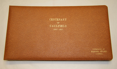 Glen Eira City Council History and Heritage Collection
Album - Album, photographic, "Centenary of Caulfield, 1857- 1957", c. 1957
The 100th anniversary of the proclamation and declaration of the "Caulfield Road District" was held on 15 October 1957. A variety of public events were organised to celebrate this memorable occasion between 13 October and 8 November 1957. The "Centenary of Caulfield 1857-1957" photograph album which contains annotated images of these events is considered of great historical importance as a unique record of Caulfield events, people and places during this time. The Caulfield Centenary events were held between 13 October and 8 November 1957. Key participants included the Mayor of the City of Caulfield, Councillors, officers, and a wide range of community groups. The events included: a special Centenary Council Meeting at the Town Hall on 15 October; an opening ceremony; two receptions; two religious services; a naturalisation ceremony; an evening community float parade; a children's carnival at Caulfield Racecourse; the crowning of Centenary Queen and an impressive fireworks display. Light brown leather bound photograph album with embossed in gold lettering on the front and centre of the Album. Contains a series of annotated B/W photographs taken as part of the Centenary of Caulfield celebrations which took place in the local area including the Caulfield Town Hall between 13 October and 8 November 1957. portico"Centenary of Caulfield 1857-1957 Photography by Hermes Studio Carnegie"caulfield road district, anniversary, centenary, 1957, city of caulfield -
 Wodonga & District Historical Society Inc
Domestic object - Meat Safe known as a "Coolgardie safe", Early 1900s
The Coolgardie safe was invented in the late 1890s on the Western Australian goldfields. Its invention was credited to a local contractor named Arthur Patrick McCormick. It was a practical system to preserve food prior to modern refrigeration. The wire grid kept the food safe from vermin and allowed breeze to blow through. It was often covered with wet hessian so that as the breeze circulated the water evaporated, creating the same concept as coolant in modern refrigerators and ice boxes. In most respects it was a variation of the bushman’s hessian bag hanging in a tree. In larger towns and cities during this time period large "ice works" could deliver block ice to areas that required a form of refrigeration. These ice blocks where held in early refrigerators to keep perishables cool. In isolated or rural households, the Coolgardie or meat safe was the next best, practical solution for food preservation. This safe was used in the home of the Conway family in Wodonga.This item is very significant to the Wodonga region as it represents the initiative and problem solving skills of the early settlers. It also reflects the primitive conditions in which they lived before the arrival of more modern services such as electricity.Meat safe or Coolgardie safe manufactured in Australia. This safe is made from metal and has been painted in green paint. 2 sides of the safe have a pattern of 6 squares of holes to allow for ventilation and air flow. The holes would also guard against insects and other vermin. There is one shelf inside, dividing it into 2 sections. The safe has a hook attached so that it can be suspended, often from a tree or on a verandah to increase air flow. The safe would often be covered by wet hessian to promote further cooling and preservation of foods such as milk, butter and meat.coolgardie safe, food preservation, pioneers innovation -
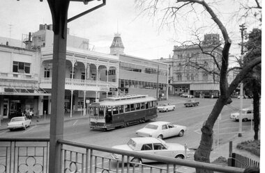
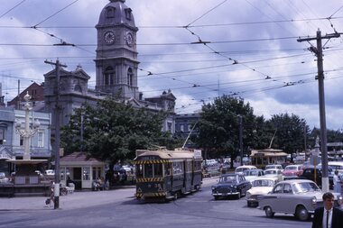
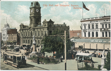 Ballarat Tramway Museum
Postcard, Valentine & Sons Publishing Co, "City Hall and Shoppers Square Ballarat", 1905
Printed colour postcard titled "City Hall and Shoppers Square Ballarat". Has an inbound tram showing the Grenville St sign on the rear, and one of the crossbench cars loading passengers outside the Town Hall. Shows Snows building, people in the median strip - busy holiday or a Sunday. Images of the front and back of the card and a close-up of the two trams in the bottom left-hand corner. Note the lamp or coloured destination sign on the roof of the inbound tram. On the rear, the postcard has been divided into two with the words "Post Card" and "Printed in Great Britain" on the top, a "Valentine Series" on the side. Addressed to Miss J Johnstone, 30 Weighbridge St, Flemington, and with the words "Dear Jeannie, / How do you like this one. / Maggie". Has a 1d Victorian stamp, cancelled in Melbourne "5" with the date "25-1-05" This is an incorrect date - electric trams did not open until August 1905. 2nd copy unused.Yields information about the intersection of Sturt and Armstrong StreetsPostcard, coloured, divided back - used.trams, tramways, sturt st, esco, town hall, cross bench tram, snows, armstrong st -
 Wodonga & District Historical Society Inc
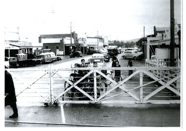
Photograph - High Street, Wodonga Level Crossing, 1954
This image is representative of many photographs illustrating the level crossing in the centre of Wodonga. Since its opening in 1873 the railway line had crossed High Street, originally called Sydney Road. It bisected the city with level crossing gates frequently stopping the flow of traffic and pedestrians as trains passed through. Signal Box B stood on the eastern side of the High Street level crossing and a big wheel closed and opened the gates. On 17th September, 1961, it was replaced by boom gates and flashing lights. The railway crossing was removed from High Street as part of the Wodonga Rail Bypass project. This involved a 5.5 kilometres bypass, the elimination of 11 level crossings and the relocation of the Wodonga station. It was moved from its original central location to a position on a new line on the northern edge of the town. The old station closed on 8 November 2008 and the new station opened on 25 June 2011.This image has local and statewide significance as it captures the former crossing in a major railway system. The railways played a critical role in opening up Victoria and connecting Australia for trade, business, social communication and transport.A black and white photo of the railway level crossing in High Street, Wodonga with gates closed. The Melbourne to Sydney railway line went through the centre of Wodonga and trains frequently held up internal vehicular and pedestrian traffic in the main street. railways wodonga, wodonga railway relocation, high st wodonga rail crossing -
 Ballarat Tramway Museum
Slide - 35mm slide/s - set of 14, Noel Simons, 23/11/1962 12:00:00 AM
Set of 14 Kodachrome transparencies taken on 23/11/1962. 1162.1 - tram 38 turning into Lydiard St. North from Sturt St. with tram 20 in background. Many motor vehicles in photo. 1162.2 - as above, but a minute of so later. Has Mutual Life building in background as well as Town Hall. 1162.3 - No. 40 entering Albert St. from Skipton St. outbound to Sebastopol. 1162.4 - No. 40 near start of side of the road running in Albert St. heading to Sebastopol. 1162.5 - No. 40 at the City terminus, on the South side of Sturt St. Has Town Hall and other buildings along the south side of Sturt St. in the background. 1162.6 - No. 40 at Sebastopol terminus - shows arrangement of the signs at the terminus. 1162.7 - No. 40 and No. 38 crossing at loop between Sayle and Grey St. No. 40 inbound. 1162.8 - No. 40 turning from Drummond St. South to Sturt St. at Hospital Corner with Southern Cross Hotel in background. 1162.9 - No. 18 in Wendouree Parade near Forest St. heading east with destination of "Victoria St." 1162.10 - Nos 41 and 39 at Depot Junction. Both trams have SEC ads. 1162.11 - No. 39 turning into the depot from Wendouree Parade - showing destination of "Gardens via Drummond Nth" 1162.12- No. 17 at Lydiard St. North terminus, showing destination of "Grey St. Sebas". Has a Twin Lakes sign 1162.13 - ditto, but with trolley pole turned around. Has SEC Briquettes roof ad and Whitehorse whiskey ad on rear dash panel. 1162.14 - No. 40 outbound to Sebastopol crossing Albert St. 1162.1 -"Nos. 38 and 20 in Sturt St. Ballarat at corner of Lydiard St." 1162.2 - "No. 38 turns into Lydiard St. as No. 20 waits at stop in Sturt St. Ballarat" 1162.3 - "No. 40 entering Albert St. from Skipton St. Redan on Sebastopol route." 1162.4 - "No 40 at beginning of reserved track on Sebastopol route, Albert St. Redan." 1162.5 - "No. 40 in Sturt St. Ballarat near cnr. of Armstrong St." 1162.6 - "No. 40 at Sebastopol terminus" 1162.7 - "No. 38 and 40 crossing at Sayle St. Loop on Albert St. reserved track, Sebastopol route" 1162.8 - "No. 40 turning into Sturt St. from Drummond St." 1162.9 - "No. 18 in Wendouree Pde. Ballarat near tramway depot" 1162.10 - "No. 41 and 39 outside Ballarat tramway depot, Lake Wendouree in background" 1162.11 - "No. 39 entering tramway depot from Wendouree Parade, Ballarat" 1162.12 - "No 17 at Lydiard St. North terminus, Ballarat North" 1162.13 - "No 17 at Lydiard St. North terminus, Ballarat North" 1162.14 - "No. 40 crossing Albert St. Sebastopol as reserved track switches from left to right of road" All have date stamp of "23 Nov. 1962" in purple ink. All black ink unless otherwise noted.tramways, trams, ballarat, albert st., sturt st., sebastopol, grey st., hospital corner, wendouree parade, depot junction, lydiard st. north, tram 17, tram 18, tram 20, tram 38, tram 39, tram 40, tram 41 -
 Kew Historical Society Inc
Plan, Melbourne & Metropolitan Board of Works : Borough of Kew : Detail Plan No.1350, 1910
The Melbourne and Metropolitan Board of Works (MMBW) plans were produced from the 1890s to the 1950s. They were crucial to the design and development of Melbourne's sewerage and drainage system. The plans, at a scale of 40 feet to 1 inch (1:480), provide a detailed historical record of Melbourne streetscapes and environmental features. Each plan covers one or two street blocks (roughly six streets), showing details of buildings, including garden layouts and ownership boundaries, and features such as laneways, drains, bridges, parks, municipal boundaries and other prominent landmarks as they existed at the time each plan was produced. (Source: State Library of Victoria). This plan forms part of a large group of MMBW plans and maps that was donated to the Society by the Mr Poulter, City Engineer of the City of Kew in 1989. Within this collection, thirty-five hand-coloured plans, backed with linen, are of statewide significance as they include annotations that provide details of construction materials used in buildings in the first decade of the 20th century as well as additional information about land ownership and usage. The copies in the Public Record Office Victoria and the State Library of Victoria are monochrome versions which do not denote building materials so that the maps in this collection are invaluable and unique tools for researchers and heritage consultants. A number of the plans are not held in the collection of the State Library of Victoria so they have the additional attribute of rarity.Original survey plan, issued by the MMBW to a contractor with responsibility for constructing sewers in the area identified on the plan within the Borough of Kew. The plan was at some stage hand-coloured, possibly by the contractor, but more likely by officers working in the Engineering Department of the Borough and later Town, then City of Kew. The hand-coloured sections of buildings on the plan were used to denote masonry or brick constructions (pink), weatherboard constructions (yellow), and public buildings (grey). MMBW Plan No. 1350 depicts the western end of Studley Park on the north side of the Studley Park Road. ‘Raheen’, then the home of Sir Henry Wrixon is named, the plan identifying those parts of the house that were built of brick and timber. The two houses between Raheen and the River Yarra are also shown. Other parts of the plan show neighbouring streets: Yarra Street, Studley Park Avenue, Studley Street and Fenwick Street. Each, apart from Fenwick Street was subsequently renamed. At the corner of Fenwick and Stawell Streets, the home of Joseph Butterworth Coombs, later called ‘Hope Mansell’, is represented but unnamed.melbourne and metropolitan board of works, detail plans, mmbw 1350, cartography -
 Kew Historical Society Inc
Plan, Melbourne & Metropolitan Board of Works : Borough of Kew : Detail Plan No.1565, 1905
The Melbourne and Metropolitan Board of Works (MMBW) plans were produced from the 1890s to the 1950s. They were crucial to the design and development of Melbourne's sewerage and drainage system. The plans, at a scale of 40 feet to 1 inch (1:480), provide a detailed historical record of Melbourne streetscapes and environmental features. Each plan covers one or two street blocks (roughly six streets), showing details of buildings, including garden layouts and ownership boundaries, and features such as laneways, drains, bridges, parks, municipal boundaries and other prominent landmarks as they existed at the time each plan was produced. (Source: State Library of Victoria). This plan forms part of a large group of MMBW plans and maps that was donated to the Society by the Mr Poulter, City Engineer of the City of Kew in 1989. Within this collection, thirty-five hand-coloured plans, backed with linen, are of statewide significance as they include annotations that provide details of construction materials used in buildings in the first decade of the 20th century as well as additional information about land ownership and usage. The copies in the Public Record Office Victoria and the State Library of Victoria are monochrome versions which do not denote building materials so that the maps in this collection are invaluable and unique tools for researchers and heritage consultants. A number of the plans are not held in the collection of the State Library of Victoria so they have the additional attribute of rarity.Original survey plan, issued by the MMBW to a contractor with responsibility for constructing sewers in the area identified on the plan within the Borough of Kew. The plan was at some stage hand-coloured, possibly by the contractor, but more likely by officers working in the Engineering Department of the Borough and later Town, then City of Kew. The hand-coloured sections of buildings on the plan were used to denote masonry or brick constructions (pink), weatherboard constructions (yellow), and public buildings (grey). MMBW Plan No.1565 is an example of a plan where a number of streets have been created since the area was surveyed, or in other cases renamed. The plan shows those streets that were bordered by Ross Street, Mount Street, Sackville Street and Burke Road. Since 1905, Mawson Street has been created and Mont Albert Road renamed as Dean Street. Named houses on the plan include ‘Tyrol’, ‘Glengorse’, ‘Theodore Villa’, ‘Arncliffe’, ‘Ballynira’ and ‘Hazeldene’. The plan also shows a Wesleyan Church in Sackville Street. In 1883, the Church’s Sunday School celebrated its silver anniversary.melbourne and metropolitan board of works, detail plans, mmbw 1565, cartography -
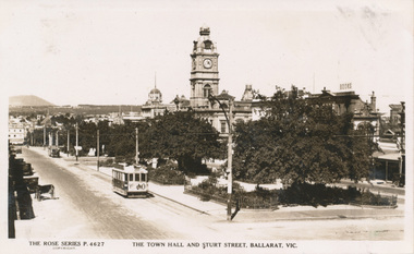 Ballarat Tramway Museum
Photograph - Digital image, Rose Stereograph Co, c1930
Yields information the appearance of Sturt St from Doveton St looking east and ESCo including the possibility of a horse tram being towed.Digital image from the Wal Jack Ballarat Album of Rose Series postcard No. 4627, of looking east from Doveton St along Sturt St with the Town Hall in the background. Two ESCo trams are in the photograph, the one nearest the camera with a "Vote No" advertisement on the back of the tram. The second tram, the furthermost from the camera appears to be towing a horse tram trailer. See image i3. Alan Bradley advised 22/12/11 - "The picture appears to be taken in 1930, which was the year of a local option referendum. There are several pics showing ESCo trams with "VOTE NO"on the ends. In my research someone noted a tram with "VOTE YES "on one end and "VOTE NO"on the other! A black car on the south side appears to be a late 1920s model. If the front tram is towing a horse tram trailer, it would be for the bicycle carrying service. Many employees on the morning shift rode to the depot to sign on, and signed off in the city so their bikes needed to be transported." Published by Rose Stereograph Co., Armadale Victoria. For rear of postcard - see image i2.trams, tramways, sturt st, esco, trailers -
 Federation University Historical Collection
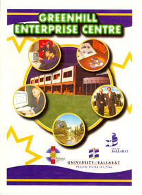
Magazine, Greenhill Enterprise Centre Magazine
This magazine was probably a supplement of the Ballarat Courier at the time of the opening of the Greenhill Enterprise Centre, Ballarat Technology Park. 31 October 1997 - Official opening of Greenhill Enterprise Centre by the Hon. Alan Stockdale, Treasurer and minister for multimedia. Coloured magazine of 18 pages relating to the Greenhill Enterprise Centre. Contents include: * What is an enterprise Centre? * Ballarat well placed to be regional IT leader * Alan Stockdale to open Greenhill Enterprise Centre * Push to create 6000 IT jobs by year 2010 * Internet to bring world to Ballarat * Boost for Remote Schooling * Keeping on track with OZtrack * Ozdate improves methods of data collection * Benefits in university and IBM relationship * Centre for Rural and Regional Information One of first tenants. * IT exchange program to benefit university students * Complementing the environment. * IBM Global first firm to invest in Ballarat Technology Park * University art on show at IBM Images include: * Professor David James and Premier Jeff Kennett planting a tree to mark the State Government's Support for the Greenhill Enterprise Centre * Vincent Chrisp's Architects impression of the completed Greenhill Enterprise Centre * Ballarat City Executive Director of Economic development, David Miller, at the Town Hall. *Greenhill Enterprise Centre floor plan * Associate Professor Gerry Anderson * Paul Kelly * Leanne Woodartgreenhill enterprise centre, ballarat technology park, stockdale, vincent chrisp, david james, geoff kennett, david miller, a.w. nicholson, gerry anderson, peter reid, oztrak, ozdata, centre for rural and regional information, ibm global services centre, michael chrisp, oswego state university, new york, peter biznet, ibm