Showing 8203 items matching " kew"
-
 Kew Historical Society Inc
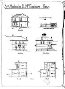
Drawing - Architectural Drawings [copy], William Pitt, Sir Malcolm D. McEacharn, Kew, 1901
... Sir Malcolm D. McEacharn, Kew..."Sir Malcolm D. McEacharn, Kew"...Studley Park Road, Kew, Victoria, Australia...Kew Historical Society Inc Kew Court House 188 High Street Kew melbourne A set of architectural drawings of additions to Goathland (originally Byram, and later Goathland and Lowan). ...A set of architectural drawings of additions to Goathland (originally Byram, and later Goathland and Lowan). The drawings, by the architect William Pitt represent additions to the size of Goathland. Pitt had previously worked with the original architect of the house, Edward George Kilburn, of Ellerker & Kilburn, who had designed Byram for the industrialist George Ramsden in 1888. 'Lost Glories: a memorial to forgotten Australian buildings' was published by David Latta in 1986. It tells the story of a number of significant Australian buildings that had previously been demolished. A chapter in the book was devoted to Goathland, later known as Tara Hall. To supplement the text, he sourced photographs from a range of suppliers, chiefly the Royal Women's Hospital which had once owned Tara Hall, but had sold it in 1960. This is one of the photographs donated to KHS by the author.Six black and white architectural drawings by the architect William Pitt for additions to the home of Sir Malcolm McEacharn in Studley Park Road. The original is in the collection of the State Library of Victoria."Sir Malcolm D. McEacharn, Kew"william pitt, malcolm mceacharn, architects -- melbourne (vic.) -- william pitt, architectural drawings, byram, tara hall, goathland -
 Kew Historical Society Inc
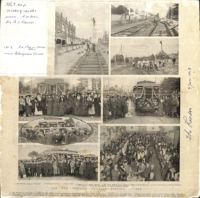
Article, The New Electric Tramway, Malvern to Kew
... The New Electric Tramway, Malvern to Kew...He worked as an adult as a clerk in the city office of the Metropolitan Gas Company, and in his role as a 'collector', he was able to photograph scenes including the construction of tramlines, railways and associated buildings in Kew, Hawthorn, Camberwell and Surrey Hills. ...Photo collage, published in The Leader newspaper in 1913, to commemorate the opening of the Malvern to Kew Tramway. The numbered photos are: 1. Kew Railway Gates at Glenferrie. 2. ...Inscribed in ink by Edgar J Dower top left: "The 3 top photographs were taken by E J Dower. No.3 Cotham Road Kew near Glenferrie Road"...Kew Historical Society Inc Kew Court House 188 High Street Kew melbourne One of a group of photographs, including three within a published photo collage , taken by Edgar James Dower in the second decade of the twentieth century. ...One of a group of photographs, including three within a published photo collage , taken by Edgar James Dower in the second decade of the twentieth century. Born and raised in Olinda, Dower later moved to Surrey Hills. He worked as an adult as a clerk in the city office of the Metropolitan Gas Company, and in his role as a 'collector', he was able to photograph scenes including the construction of tramlines, railways and associated buildings in Kew, Hawthorn, Camberwell and Surrey Hills. Later he established a real estate agency with his brother - the E.J. Dower Real Estate Agency, Mount Dandenong Office.The photo collage is an historically significant record of the development of transport infrastructure which was used to connect Victorians in the first two decades of the twentieth century. This development resulted from increases in population and the consequent extension of Melbourne's suburbs. The photographs, both individually and collectively, richly detail the labour of workers and the tools and machinery used to create and extend Melbourne's public transport network in the years preceding and during World War 1.Photo collage, published in The Leader newspaper in 1913, to commemorate the opening of the Malvern to Kew Tramway. The numbered photos are: 1. Kew Railway Gates at Glenferrie. 2. Burke Road Terminus. 3. Final Stages. 4. Ladies at the Official Opening. 5. The Acting Mayoress of Kew Cutting the Ribbon at the Kew Boundary. 6. Mayor and Councillors at the Kew Terminus. 7. The Cutting the First Ribbon. 8. Guests at the Hawthorn Town Hall.Inscribed in ink by Edgar J Dower top left: "The 3 top photographs were taken by E J Dower. No.3 Cotham Road Kew near Glenferrie Road"theme -- connecting victorians by transport and communications, theme -- travelling by tram -
 Kew Historical Society Inc
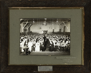
Photograph, Mayoral Concert, Kew Recreation Hall, 31 July 1906
... Mayoral Concert, Kew Recreation Hall...The Kew Recreation Hall was opened in 1880. For eighty years it was a major venue for concerts, performances, dances and civic events. ...Jellis) and the Mayoress in the audience at a mayoral concert in the Kew Recreation Hall in Wellington Street. ...[Inscription on mount] "Mayoral Concert, Recreation Hall, Kew, 31st July 1906. Cr. T. G. Jellis Mayor." ...Kew Historical Society Inc Kew Court House 188 High Street Kew melbourne The Kew Recreation Hall was opened in 1880. ...The Kew Recreation Hall was opened in 1880. For eighty years it was a major venue for concerts, performances, dances and civic events. It was demolished in 1960.This is an historically and culturally significant municipal photograph from Kew dating from 1906. The photograph has architectural significance as it is the only known, authenticated photograph of the interior of the Recreation Hall in Wellington Street before it was renovated. The Recreation Hall was of statewide significance as a centre of social activity in Kew from 1880-1960. The Mayor (Cr T.G. Jellis) and the Mayoress in the audience at a mayoral concert in the Kew Recreation Hall in Wellington Street. [Inscription on mount] "Mayoral Concert, Recreation Hall, Kew, 31st July 1906. Cr. T. G. Jellis Mayor." [Plaque] "Presented by Mayor T.G. Jellis, Mayor 1905-6"cr. t.g. jellis, mayors of kew, kew recreation hall (interior) -
 Kew Historical Society Inc
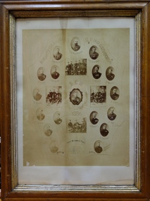
Award, Kew Fire Brigade / Best Average Time, 16 points / U.F.B.D. Sandhurst, 1886
... Kew Fire Brigade / Best Average Time, 16 points / U.F.B.D. ...1879 - The Argus, Friday 11 July 1879, page 4. The Kew Borough Council having decided to initiate a fire brigade, invited volunteers to send in their names. ...Certificate awarded to the Kew Volunteer Fire Brigade as an award for winning 'the best average time' in competition at Sandhurst. ...Inscription: "Kew Fire Brigade U.F.B.D. Sandhurst. Kew 1886: Best Average Time, 16 points"...Kew Historical Society Inc Kew Court House 188 High Street Kew melbourne 1879 - The Argus, Friday 11 July 1879, page 4. ...1879 - The Argus, Friday 11 July 1879, page 4. The Kew Borough Council having decided to initiate a fire brigade, invited volunteers to send in their names. About 40 complied with the invitation and met at the Town-hall to choose 12 of their number to form the brigade. The 12 elected then chose their officers as follows :— Councillor Gray, captain ; Mr. Thomas Greenhill, foreman ; and Mr. H. Loxton, secretary. The brigade decided to apply to the council for uniforms and a bell; and after adopting rules for their guidance the meeting separated. The brigade now possesses a reel and 500ft. of hose, and a shed is being erected in Little Walpole-street for a station. The council have applied for six additional fireplugs in the Main-road, so that the brigade may now be considered fairly established. 1886 - Globe (Sydney), Tuesday 16 March 1886, page 8 The Kew Fire Brigade, which obtained the pride of place at the recent fire brigades' demonstration, at Sandhurst, was met on their return at Spencer-street Railway Station by the Mayor and Councillors of that suburb, and were subsequently entertained at the Greyhound Hotel. 1886 - South Bourke and Mornington Journal, Wednesday 17 March 1886, page 2 It may be, deemed remarkable, but nevertheless a fact, 'that the Kew Fire Brigade, comparatively a new one, has gained premier place at the recent contest of brigades held at Ballarat, winning two first prizes and two second. On returning they were met at the station and escorted to Kew, preceded by the Borough banner. Certificate awarded to the Kew Volunteer Fire Brigade as an award for winning 'the best average time' in competition at Sandhurst. Surrounding the team's photo are a series of individual oval named portraits of the team. This framed version of the certificate, (there are two in the collection) is less faded than the framed version.The photograph without the mount (2016.0097a) has been digitally enhanced. Inscription: "Kew Fire Brigade U.F.B.D. Sandhurst. Kew 1886: Best Average Time, 16 points"kew volunteer fire brigade -
 Kew Historical Society Inc
Archive (sub-series) - Printed Civic Ephemera, Town of Kew et al, 1913-1981
... The Municipality of Kew (1860-1863), the Borough of Kew (1863-1910), the Town of Kew (1910-1921) and the City of Kew (1921-1994) were local government instrumentalities in the State of Victoria. ...Town of Kew...Kew, Greater Melbourne, Victoria, Australia...Kew Historical Society Inc Kew Court House 188 High Street Kew melbourne The Municipality of Kew (1860-1863), the Borough of Kew (1863-1910), the Town of Kew (1910-1921) and the City of Kew (1921-1994) were local government instrumentalities in the State of Victoria. ...Town Clerk's Office, City of KewPrinted cardsDate orderItems relating to civic events, typically held by mayors of the City of Kew, or invitations from other cities to Council officers or councillors. h h harrison -- town clerk -- borough of kew -- town of kew -- city of kew, w d birrell -- town clerk -- city of kew, civic ephemera - city of kewh h harrison -- town clerk -- borough of kew -- town of kew -- city of kew, w d birrell -- town clerk -- city of kew, civic ephemera - city of kew -
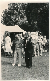 Ballarat Heritage Services
Photograph - Black and white photograph, Kew Festival, 1979
... Kew Festival...Two men stand in the Alexandria Gardens during the Kew Festival ....Kew, Victoria, Australia...Ballarat Heritage Services PO Box 2209 Bakery Hill Post Office goldfields city of kew kew festival colonial dance kew town hall bushwhackers martin o'toole lawrence o'toole Two men stand in the Alexandria Gardens during the Kew Festival . ...Two men stand in the Alexandria Gardens during the Kew Festival .city of kew, kew festival, colonial dance, kew town hall, bushwhackers, martin o'toole, lawrence o'toole -
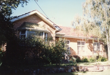 Ballarat Heritage Services
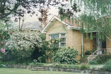
Photograph - Photograph - Colour, Chellowdene, 37 Wills St, Kew, c1973, 08/03/1990
... Chellowdene, 37 Wills St, Kew, c1973...A cream brick house in Wills Street, Kew. It was known as Chellowdene. ...37 Wills Street , Kew, Victoria, Australia...Ballarat Heritage Services PO Box 2209 Bakery Hill Post Office goldfields Chellowdene was demolished c1996, and four units were built on the block. chellowdene 37 wills st kew A cream brick house in Wills Street, Kew. ...Chellowdene was demolished c1996, and four units were built on the block.A cream brick house in Wills Street, Kew. It was known as Chellowdene. chellowdene, 37 wills st kew -
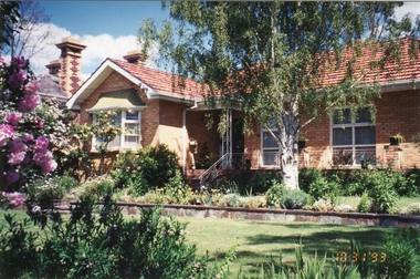 Ballarat Heritage Services
Photograph - Photograph - Colour, Chellowdene, 37 Wills St, Kew, 1993, 03/10/1993
... Chellowdene, 37 Wills St, Kew, 1993...A cream brick house in Wills Street, Kew. It was known as Chellowdene. ...37 Wills Street , Kew, Victoria, Australia...The Wood Family and the Gervasoni Family. chellowdene 37 wills st kew architecture A cream brick house in Wills Street, Kew. ...Chellowdene was demolished c1996, and four units were built on the block. It has two owners. The Wood Family and the Gervasoni Family.A cream brick house in Wills Street, Kew. It was known as Chellowdene. chellowdene, 37 wills st kew, architecture -
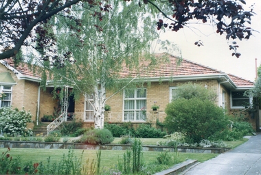 Ballarat Heritage Services
Photograph - Photograph - Colour, Chellowdene, 37 Wills St, Kew, 1990, c1990
... Chellowdene, 37 Wills St, Kew, 1990...A cream brick house in Wills Street, Kew. It was known as Chellowdene. ...37 Wills Street , Kew, Victoria, Australia...The Wood Family and the Gervasoni Family. chellowdene 37 wills st kew architecture A cream brick house in Wills Street, Kew. ...Chellowdene was demolished c1996, and four units were built on the block. It has two owners. The Wood Family and the Gervasoni Family.A cream brick house in Wills Street, Kew. It was known as Chellowdene. chellowdene, 37 wills st kew, architecture -
 Kew Historical Society Inc
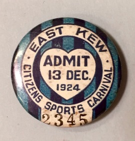
Badge - Fundraising Button, East Kew Citizens Sports Carnival: Admit 13 Dec. 1924, 1924
... East Kew Citizens Sports Carnival: Admit 13 Dec. 1924...Most of the ephemera assembled by Francis Rigg were patriotic buttons but also included come sporting event buttons including two associated with the East Kew Citizens Sports Carnival. The subdivision of the area now known as Kew East commenced before World War 1, but it was not until the 1920s that it became fully developed. ...A circular badge produced for the East Kew Citizens Sports Carnival in 1924. The badge has a ground of vertical stripes in shades of blue. ..."East Kew Citizens Sports Carnival / Admit 13 Dec. 1924"...Kew Historical Society Inc Kew Court House 188 High Street Kew melbourne Most of the ephemera assembled by Francis Rigg were patriotic buttons but also included come sporting event buttons including two associated with the East Kew Citizens Sports Carnival. ...Most of the ephemera assembled by Francis Rigg were patriotic buttons but also included come sporting event buttons including two associated with the East Kew Citizens Sports Carnival. The subdivision of the area now known as Kew East commenced before World War 1, but it was not until the 1920s that it became fully developed. At this time, there was a strong Progress Association and this body raised funds to purchase land and build the East Kew Citizen’s Hall in Normandy Road, the first stage of which was completed in 1922. This hall was designed to be extended, although this never occurred, and the building now forms part of the facilities of the East Kew Uniting Church. The ‘East Kew Citizens Sports Carnival’ may well have been a fundraiser event for the building fund. As far as is known, the carnival was only held for a couple of years.Frances Rigg was a local business identity in Kew, at one stage managing the local branch of the English, Scottish and Australian (ES&A) Bank at 175 High Street from c. 1920 until the 1940s. After Francis Rigg’s death, the collection of buttons and medallions was inherited by his son, Ken Rigg (1922-2014). The collection was subsequently donated to the Kew Historical Society in 2015 by Francis' grandson, Adrian Rigg, at the time of the Gallipoli & Beyond Commemoration in 2015. The collection covers a period of almost 40 years. The majority of the buttons are patriotic buttons, issued and sold during and immediately after the First World World War (1914-1918) to raise funds for national and overseas causes. The collection also includes a number of locally significant sporting event buttons and sporting club medallions, issued in the 1920s and 1930s.A circular badge produced for the East Kew Citizens Sports Carnival in 1924. The badge has a ground of vertical stripes in shades of blue. The name of the event is within a white circular band. A white shield in the centre includes the words “Admit” which would indicate that the badge was purchased and worn on the day of the carnival to indicate that the wearer had paid the admission fee."East Kew Citizens Sports Carnival / Admit 13 Dec. 1924"kew east, sport buttons -
 Kew Historical Society Inc
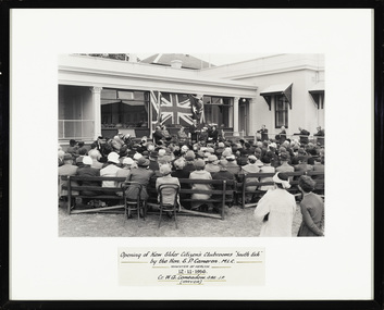
Photograph - Opening of the Kew Elder Citizens Clubrooms at 'Southesk', City of Kew, 1954
... The orthodox version of the origins and history of the Kew Elder(ly) Citizens’ Association was established by Cr. ...Framed, inscribed photograph of the opening of the Kew Elder Citizens Club at Southesk in 1954. ...‘Opening of the Kew Elder Citizens Clubrooms “South Esk” by the Hon. ...City of Kew...Kew Historical Society Inc Kew Court House 188 High Street Kew melbourne The orthodox version of the origins and history of the Kew Elder(ly) Citizens’ Association was established by Cr. ...The orthodox version of the origins and history of the Kew Elder(ly) Citizens’ Association was established by Cr. W. D. Vaughan in his book Kew’s Civic Century (1960), when he wrote that: "When Mrs. C. H. Simpson was Mayoress in 1952 she set up the Elderly Citizens’ Association to care for the needs of ages persons in Kew. The idea was strongly supported and a start was made by providing social afternoons for elderly folk at Southesk. Visiting sick people in their homes, providing firewood where needed, and other activities were undertaken by the Association. The aid of Council was sought to further the work. It was decided that a social unit for elderly folk be established at Southesk." (p.126-7). In the following pages, he describes in detail Council’s role in formally establishing the Association. This ‘official’ version was reasserted in the later Thematic Environmental History of the City of Boroondara (2012). However the origins and gestation of community of organisations is rarely straightforward. In 1965, five years after Vaughan’s book was published, the author of East Kew Women’s Club : Twenty Years : 20-7-1945-30-7-1965, writing about the period July 1947 to July 1950, described the role the Club played in establishing the Kew Elder Citizens Association. The author wrote: "At a meeting of the Kew Community Aid, the plight of many elderly people in Kew who were dependent on pensions was raised and in order to ascertain their needs the practice was begun of serving morning tea at the Masonic Hall in Walpole Street, where pensions were then paid. From this beginning the Kew Elder Citizens Association was formed in Kew with wide support, and Club members gave willing support on the committee, in helping serve afternoon tea and in entertainment." (p.4) Photographic evidence also leads to questions about Vaughan’s version of events. A framed photograph in the Society’s Collection shows a Public Meeting to form the Kew Elder Citizens Association in a room at Southesk a year earlier in 1951. Whatever version of the origins of the Association is correct, a later framed photograph in the Society’s collection shows the opening of the completed Clubrooms of the Kew Elder Citizens at South Esk by the Hon. E.P. Cameron M.L.C, Minister of Health, on 12 November 1956. The Association is still active in Kew and is currently located at Hamer Court, opposite the Boroondara General (Kew) Cemetery in High Street, Kew.Framed, inscribed photograph of the opening of the Kew Elder Citizens Club at Southesk in 1954. The ceremony would appear to be conducted on the western side of the house.‘Opening of the Kew Elder Citizens Clubrooms “South Esk” by the Hon. E.P. Cameron M.L.C, Minister of Health, 12.11.1956. Cr. W.A. Comeadow O.B.E., J.P. (Mayor).’southesk, kew elder citizens club, kew elderly citizens club, kew senior citizens club -
 Kew Historical Society Inc
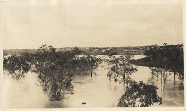
Photograph, Marnie McLeod, Floods on the River Yarra at Kew, 1916
... Floods on the River Yarra at Kew......kew...The Age published an article - Valuable Gardens Destroyed at Kew - on 25 September 1916: "VALUABLE GARDENS DESTROYED AT KEW. ...Inscription on reverse in ink "(pre 1920) Flood from Zig-zag bridge Yarra River, Kew Vic."...Kew Historical Society Inc Kew Court House 188 High Street Kew melbourne The donation was accompanied by the following letter from the donor: "Hi. ...The donation was accompanied by the following letter from the donor: "Hi. I found these in with family photos. Taken by family as Mamie McLeod was living in Fellows Street, Kew, so would be near there. Retain (or discard) as you see fit." [Donor's name and address withheld from public view]. To gain an insight into the flood levels at Kew, it is worth reading newspaper accounts of the event. The Age published an article - Valuable Gardens Destroyed at Kew - on 25 September 1916: "VALUABLE GARDENS DESTROYED AT KEW. From the heights of Studley Park, Kew, a splendid view of the flood waters can be obtained, and yesterday afternoon, despite continuous rain, crowds of citizens assembled there to witness the spectacle. There is a vast stretch of water some 300 or 400 yards broad, above the foot bridge connecting Gipps-street, Collingwood, and Studley Park. The river is only about 3 feet from the top of the embankment connecting with the ramp of the bridge on the Studiey Park side. When the upper llood waters come down it is almost a certainty that tne embankment will be submerged and the bridge rendered impassible. Below the bridge the waters again stretch out, and have submerged all the low-lying land on the Collingwood side and invaded the back premises ot the Kodak Co., Phoenix Biscuit Factory, a tannery adjoining thereto, the Shamrock Brewery, and Chinese gardens in the vicinity. At Walmer-street-bridge, at the end of Studley Park, the low-lying land on the Kew side is covered with water to the depth of many feet. Tlie land in question is owned in a great part by Mr Frank Lavers who haa gone in for intense culture on a pretty liberal scale on both the slopes of the hill and on the river flat. On the latter he is cultivating many acres of asparagus, and has at a considerable cost spent three years in preparing the ground and installing an irrigation system, reticulated from the Yan Yean water supply. This year the asparagus was put down, and the plants were in a promising condition. Tlie flood waters are now flowing fast over the land. The crop is ruined, and three years' work and expenditure destroyed. Mr. Laver's private residence fortunately is high above flood level, but two houses he owns off Young-street have been flooded out. Having been warned in time, the tenants removed their furniture hefore the water came down to Mr. Laver's residence, where they themselves have been given accommodation in the meantime. All the river flats in East Kew are under water. One or two low-lying houses have been flooded. Chipperfield's boat shed at Willsmere is nearly covered, and some Chinese gardens in the vicinity are several feet under water."This, and the other three photographs donated of floods in Kew are believed to be the earliest in the collection. Together with our original MMBW River Yarra map showing flood levels, these items, when compared allow researchers to gain a visual perspective of the extent of the flood in 1916. Panoramic view, believed to be looking north towards Fairfield from the Zig-Zag Bridge on the River Yarra. The inscription on the reverese identifies it as taken before 1920.Inscription on reverse in ink "(pre 1920) Flood from Zig-zag bridge Yarra River, Kew Vic."river yarra, kew, floods 1916, zig-zag bridge -
 Kew Historical Society Inc
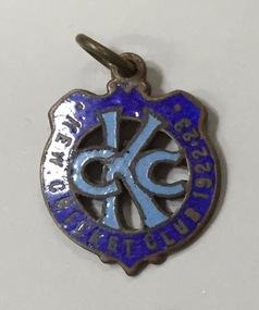
Unknown - Membership Medallion, Kew Cricket Club KCC 1922-1923, 1922
... Kew Cricket Club KCC 1922-1923...Frances Rigg was a local business identity in Kew, ultimately managing the local branch of the English, Scottish and Australian (ES&A) Bank at 175 High Street, Kew from c. 1920 until the 1940s. ...Blue enamel on metal membership medallion produced by the Kew Cricket Club for the year 1922-23 and which belonged to Francis Horace Rigg (1882-1946). ...Kew Cricket Club KCC 1922-1923...Kew Historical Society Inc Kew Court House 188 High Street Kew melbourne Frances Rigg was a local business identity in Kew, ultimately managing the local branch of the English, Scottish and Australian (ES&A) Bank at 175 High Street, Kew from c. 1920 until the 1940s. ...Frances Rigg was a local business identity in Kew, ultimately managing the local branch of the English, Scottish and Australian (ES&A) Bank at 175 High Street, Kew from c. 1920 until the 1940s. After Francis Rigg’s death, the collection of buttons and medallions was inherited by his son, Ken Rigg (14/11/1922-19/01/2014). The collection was subsequently donated to the Kew Historical Society in 2015 by his grandson Adrian Rigg at the time of the Gallipoli & Beyond Commemoration.The collection covers a period of almost 40 years. The majority of the buttons are patriotic buttons, issued and sold during and immediately after the First World World War (1914-1918) to raise funds for national and overseas causes. The collection also includes a number of locally significant sporting event buttons and sporting club medallions, issued in the 1920s and 1930s.Blue enamel on metal membership medallion produced by the Kew Cricket Club for the year 1922-23 and which belonged to Francis Horace Rigg (1882-1946). The medallion in shield shape is enameled in shades of blue with the initials of the Club, KCC surrounded by the full name of the club and the period for which the member would gain access to games.Kew Cricket Club KCC 1922-1923kew cricket club, membership medallions -
 Kew Historical Society Inc
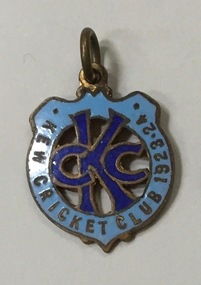
Unknown - Membership Medallion, Kew Cricket Club KCC 1923-1924, 1923
... Kew Cricket Club KCC 1923-1924...Frances Rigg was a local business identity in Kew, ultimately managing the local branch of the English, Scottish and Australian (ES&A) Bank at 175 High Street, Kew from c. 1920 until the 1940s. ...Blue enamel on metal membership medallion produced by the Kew Cricket Club for the year 1923-24 and which belonged to Francis Horace Rigg (1882-1946). ...Kew Cricket Club KCC 1923-1924...Kew Historical Society Inc Kew Court House 188 High Street Kew melbourne Frances Rigg was a local business identity in Kew, ultimately managing the local branch of the English, Scottish and Australian (ES&A) Bank at 175 High Street, Kew from c. 1920 until the 1940s. ...Frances Rigg was a local business identity in Kew, ultimately managing the local branch of the English, Scottish and Australian (ES&A) Bank at 175 High Street, Kew from c. 1920 until the 1940s. After Francis Rigg’s death, the collection of buttons and medallions was inherited by his son, Ken Rigg (14/11/1922-19/01/2014). The collection was subsequently donated to the Kew Historical Society in 2015 by his grandson Adrian Rigg at the time of the Gallipoli & Beyond Commemoration.The collection covers a period of almost 40 years. The majority of the buttons are patriotic buttons, issued and sold during and immediately after the First World World War (1914-1918) to raise funds for national and overseas causes. The collection also includes a number of locally significant sporting event buttons and sporting club medallions, issued in the 1920s and 1930s.Blue enamel on metal membership medallion produced by the Kew Cricket Club for the year 1923-24 and which belonged to Francis Horace Rigg (1882-1946). The medallion in shield shape is enameled in shades of blue with the initials of the Club, KCC surrounded by the full name of the club and the period for which the member would gain access to games.Kew Cricket Club KCC 1923-1924kew cricket club, membership medallions -
 Kew Historical Society Inc
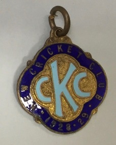
Unknown - Membership Medallion, Kew Cricket Club KCC 1928-29, 1928
... Kew Cricket Club KCC 1928-29...Frances Rigg was a local business identity in Kew, ultimately managing the local branch of the English, Scottish and Australian (ES&A) Bank at 175 High Street, Kew from c. 1920 until the 1940s. ...Blue and gilt enamel on metal membership medallion produced by the Kew Cricket Club for the year 1928-29 and which belonged to Francis Horace Rigg (1882-1946). ...Kew Cricket Club KCC 1928-29...Kew Historical Society Inc Kew Court House 188 High Street Kew melbourne Frances Rigg was a local business identity in Kew, ultimately managing the local branch of the English, Scottish and Australian (ES&A) Bank at 175 High Street, Kew from c. 1920 until the 1940s. ...Frances Rigg was a local business identity in Kew, ultimately managing the local branch of the English, Scottish and Australian (ES&A) Bank at 175 High Street, Kew from c. 1920 until the 1940s. After Francis Rigg’s death, the collection of buttons and medallions was inherited by his son, Ken Rigg (14/11/1922-19/01/2014). The collection was subsequently donated to the Kew Historical Society in 2015 by his grandson Adrian Rigg at the time of the Gallipoli & Beyond Commemoration.The collection covers a period of almost 40 years. The majority of the buttons are patriotic buttons, issued and sold during and immediately after the First World World War (1914-1918) to raise funds for national and overseas causes. The collection also includes a number of locally significant sporting event buttons and sporting club medallions, issued in the 1920s and 1930s.Blue and gilt enamel on metal membership medallion produced by the Kew Cricket Club for the year 1928-29 and which belonged to Francis Horace Rigg (1882-1946). The medallion is enameled in shades of blue and gold with the initials of the Club, KCC surrounded by the full name of the club and the period for which the member would gain access to games.Kew Cricket Club KCC 1928-29kew cricket club -
 Kew Historical Society Inc
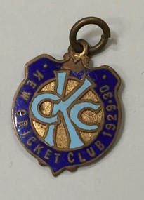
Unknown - Membership Medallion, Kew Cricket Club KCC 1929-1930, 1929
... Kew Cricket Club KCC 1929-1930...Frances Rigg was a local business identity in Kew, ultimately managing the local branch of the English, Scottish and Australian (ES&A) Bank at 175 High Street, Kew from c. 1920 until the 1940s. ...Blue and gilt enamel on metal membership medallion produced by the Kew Cricket Club for the year 1929-30 and which belonged to Francis Horace Rigg (1882-1946). ...Kew Cricket Club KCC 1929-1930...Kew Historical Society Inc Kew Court House 188 High Street Kew melbourne Frances Rigg was a local business identity in Kew, ultimately managing the local branch of the English, Scottish and Australian (ES&A) Bank at 175 High Street, Kew from c. 1920 until the 1940s. ...Frances Rigg was a local business identity in Kew, ultimately managing the local branch of the English, Scottish and Australian (ES&A) Bank at 175 High Street, Kew from c. 1920 until the 1940s. After Francis Rigg’s death, the collection of buttons and medallions was inherited by his son, Ken Rigg (14/11/1922-19/01/2014). The collection was subsequently donated to the Kew Historical Society in 2015 by his grandson Adrian Rigg at the time of the Gallipoli & Beyond Commemoration.The collection covers a period of almost 40 years. The majority of the buttons are patriotic buttons, issued and sold during and immediately after the First World World War (1914-1918) to raise funds for national and overseas causes. The collection also includes a number of locally significant sporting event buttons and sporting club medallions, issued in the 1920s and 1930s.Blue and gilt enamel on metal membership medallion produced by the Kew Cricket Club for the year 1929-30 and which belonged to Francis Horace Rigg (1882-1946). The medallion is enameled in shades of blue and gold with the initials of the Club, KCC surrounded by the full name of the club and the period for which the member would gain access to games.Kew Cricket Club KCC 1929-1930kew cricket club, membership medallions -
![William Stevenson, Mayor [of Kew] 1865-6](/media/collectors/550653872162f11fb04854aa/items/592282edd0cef20e04ba5fb5/item-media/5c1966fd21ea6e0dacb63aeb/item-fit-380x285.jpg?cb=6) Kew Historical Society Inc
Kew Historical Society IncPhotograph, J E Barnes, William Stevenson, Mayor [of Kew] 1865-6, 1906
... William Stevenson, Mayor [of Kew] 1865-6...Kew achieved independence from the Boroondara Roads Board in 1860. ...William Stevenson, Mayor of Kew 1865-6. The mounting and framing of the photograph follows a typical layout or style in that each is framed in dark wood, glazed, and laid down on an inscribed board. ...William Stevenson, Mayor [of Kew] 1865-6...Kew Historical Society Inc Kew Court House 188 High Street Kew melbourne Kew achieved independence from the Boroondara Roads Board in 1860. ...Kew achieved independence from the Boroondara Roads Board in 1860. As a new municipality, its first three leaders were designated as chairmen. On becoming a borough in 1863, its leaders were identified as mayors. The earliest photographs date from ca.1906, when the Town of Kew commissioned the noted local photographer Josiah E Barnes to produce standardised portraits of former mayors to be displayed in the Mayoral Chamber of the Town Hall. The collection also includes photographs by other well-known photographic studios such as Burlington Studios, Melba – Melbourne, Stuart Tompkins, Spencer Shier and Talma & Co. The majority of mounts identify the photographer. Eighty photographs are housed in their original frames.This portrait is one of a series of mounted and framed photographic portraits of mayors and town clerks of the former Borough, Town and City of Kew. The portraits were transferred by the City of Kew to the Kew Historical Society in March 1989. A Significance Assessment in 2018, funded by the National Library of Australia confirmed the historic, and often artistic significance of the series.Framed portrait of Cr. William Stevenson, Mayor of Kew 1865-6. The mounting and framing of the photograph follows a typical layout or style in that each is framed in dark wood, glazed, and laid down on an inscribed board. The inscription identifies the name of the mayor and the year/s that he/she served.William Stevenson, Mayor [of Kew] 1865-6mayors of kew (vic), cr. william stevenson, kew (vic.) — municipal collection -
![George Y. Fishley, Mayor [of Kew] 1870](/media/collectors/550653872162f11fb04854aa/items/5922836bd0cef20e04ba9c73/item-media/5c1ab43421ea770a582946ae/item-fit-380x285.jpg?cb=6) Kew Historical Society Inc
Kew Historical Society IncPhotograph, J E Barnes, George Y. Fishley, Mayor [of Kew] 1870, 1906
... Fishley, Mayor [of Kew] 1870...Kew achieved independence from the Boroondara Roads Board in 1860. ...George Y. Fishley, Mayor of Kew in 1870. The mounting and framing of the photograph follows a typical layout or style in that each is framed in dark wood, glazed, and laid down on an inscribed board. ...Fishley, Mayor [of Kew] 1870...Kew Historical Society Inc Kew Court House 188 High Street Kew melbourne Kew achieved independence from the Boroondara Roads Board in 1860. ...Kew achieved independence from the Boroondara Roads Board in 1860. As a new municipality, its first three leaders were designated as chairmen. On becoming a borough in 1863, its leaders were identified as mayors. The earliest photographs date from ca.1906, when the Town of Kew commissioned the noted local photographer Josiah E Barnes to produce standardised portraits of former mayors to be displayed in the Mayoral Chamber of the Town Hall. The collection also includes photographs by other well-known photographic studios such as Burlington Studios, Melba – Melbourne, Stuart Tompkins, Spencer Shier and Talma & Co. The majority of mounts identify the photographer. Eighty photographs are housed in their original frames.This portrait is one of a series of mounted and framed photographic portraits of mayors and town clerks of the former Borough, Town and City of Kew. The portraits were transferred by the City of Kew to the Kew Historical Society in March 1989. A Significance Assessment in 2018, funded by the National Library of Australia confirmed the historic, and often artistic significance of the series.Framed portrait of Cr. George Y. Fishley, Mayor of Kew in 1870. The mounting and framing of the photograph follows a typical layout or style in that each is framed in dark wood, glazed, and laid down on an inscribed board. The inscription identifies the name of the mayor and the year/s that he/she served.George Y. Fishley, Mayor [of Kew] 1870george y. fishley, mayors of kew (vic), kew (vic.) — municipal collection -
![Samuel Kellett, Mayor [of Kew] 1871-2](/media/collectors/550653872162f11fb04854aa/items/59228ebed0cf110e0409c6a2/item-media/5c1ec2de21eabb0988e9b722/item-fit-380x285.jpg?cb=6) Kew Historical Society Inc
Kew Historical Society IncPhotograph, J E Barnes, Samuel Kellett, Mayor [of Kew] 1871-2, 1906
... Samuel Kellett, Mayor [of Kew] 1871-2...Kew achieved independence from the Boroondara Roads Board in 1860. ...Samuel Kellett, Mayor of Kew]1871-2. The mounting and framing of the photograph follows a typical layout or style in that each is framed in dark wood, glazed, and laid down on an inscribed board. ...Samuel Kellett, Mayor [of Kew] 1871-2...Kew Historical Society Inc Kew Court House 188 High Street Kew melbourne Kew achieved independence from the Boroondara Roads Board in 1860. ...Kew achieved independence from the Boroondara Roads Board in 1860. As a new municipality, its first three leaders were designated as chairmen. On becoming a borough in 1863, its leaders were identified as mayors. The earliest photographs date from ca.1906, when the Town of Kew commissioned the noted local photographer Josiah E Barnes to produce standardised portraits of former mayors to be displayed in the Mayoral Chamber of the Town Hall. The collection also includes photographs by other well-known photographic studios such as Burlington Studios, Melba – Melbourne, Stuart Tompkins, Spencer Shier and Talma & Co. The majority of mounts identify the photographer. Eighty photographs are housed in their original frames.This portrait is one of a series of mounted and framed photographic portraits of mayors and town clerks of the former Borough, Town and City of Kew. The portraits were transferred by the City of Kew to the Kew Historical Society in March 1989. A Significance Assessment in 2018, funded by the National Library of Australia confirmed the historic, and often artistic significance of the series.Framed portrait of Cr. Samuel Kellett, Mayor of Kew]1871-2. The mounting and framing of the photograph follows a typical layout or style in that each is framed in dark wood, glazed, and laid down on an inscribed board. The inscription identifies the name of the mayor and the year/s that he/she served.Samuel Kellett, Mayor [of Kew] 1871-2cr. samuel kellett, mayors of kew (vic), kew (vic.) — municipal collection -
![H. Hedderwick, Mayor [of Kew] 1873-5](/media/collectors/550653872162f11fb04854aa/items/59228eeed0cf110e0409f209/item-media/5c1ebbcb21ea9009881b29b7/item-fit-380x285.jpg?cb=6) Kew Historical Society Inc
Kew Historical Society IncPhotograph, J E Barnes, H. Hedderwick, Mayor [of Kew] 1873-5, c.1906
... Hedderwick, Mayor [of Kew] 1873-5...Kew achieved independence from the Boroondara Roads Board in 1860. ...Hedderwick, Mayor of Kew 1873-5. The mounting and framing of the photograph follows a typical layout or style in that each is framed in dark wood, glazed, and laid down on an inscribed board. ...Hedderwick, Mayor [of Kew] 1873-5...Kew Historical Society Inc Kew Court House 188 High Street Kew melbourne Kew achieved independence from the Boroondara Roads Board in 1860. ...Kew achieved independence from the Boroondara Roads Board in 1860. As a new municipality, its first three leaders were designated as chairmen. On becoming a borough in 1863, its leaders were identified as mayors. The earliest photographs date from ca.1906, when the Town of Kew commissioned the noted local photographer Josiah E Barnes to produce standardised portraits of former mayors to be displayed in the Mayoral Chamber of the Town Hall. The collection also includes photographs by other well-known photographic studios such as Burlington Studios, Melba – Melbourne, Stuart Tompkins, Spencer Shier and Talma & Co. The majority of mounts identify the photographer. Eighty photographs are housed in their original frames.This portrait is one of a series of mounted and framed photographic portraits of mayors and town clerks of the former Borough, Town and City of Kew. The portraits were transferred by the City of Kew to the Kew Historical Society in March 1989. A Significance Assessment in 2018, funded by the National Library of Australia confirmed the historic, and often artistic significance of the series.Framed portrait of Cr. H. Hedderwick, Mayor of Kew 1873-5. The mounting and framing of the photograph follows a typical layout or style in that each is framed in dark wood, glazed, and laid down on an inscribed board. The inscription identifies the name of the mayor and the year/s that he/she served.H. Hedderwick, Mayor [of Kew] 1873-5cr. h. hedderwick, mayors of kew (vic), photographers - kew (vic) - josiah earl barnes, kew (vic.) — municipal collection -
![W.J. Runting, Mayor [of Kew] 1880-2](/media/collectors/550653872162f11fb04854aa/items/59228f56d0cf110e040a5d8d/item-media/5c1e2c6021eb000dec1edeaf/item-fit-380x285.jpg?cb=6) Kew Historical Society Inc
Kew Historical Society IncPhotograph, J E Barnes, W.J. Runting, Mayor [of Kew] 1880-2, c.1906
... Runting, Mayor [of Kew] 1880-2...Kew achieved independence from the Boroondara Roads Board in 1860. ...W.J. Runting, Mayor of Kew 1880-2. The mounting and framing of the photograph follows a typical layout or style in that each is framed in dark wood, glazed, and laid down on an inscribed board. ...Runting, Mayor [of Kew] 1880-2...Kew Historical Society Inc Kew Court House 188 High Street Kew melbourne Kew achieved independence from the Boroondara Roads Board in 1860. ...Kew achieved independence from the Boroondara Roads Board in 1860. As a new municipality, its first three leaders were designated as chairmen. On becoming a borough in 1863, its leaders were identified as mayors. The earliest photographs date from ca.1906, when the Town of Kew commissioned the noted local photographer Josiah E Barnes to produce standardised portraits of former mayors to be displayed in the Mayoral Chamber of the Town Hall. The collection also includes photographs by other well-known photographic studios such as Burlington Studios, Melba – Melbourne, Stuart Tompkins, Spencer Shier and Talma & Co. The majority of mounts identify the photographer. Eighty photographs are housed in their original frames.This portrait is one of a series of mounted and framed photographic portraits of mayors and town clerks of the former Borough, Town and City of Kew. The portraits were transferred by the City of Kew to the Kew Historical Society in March 1989. A Significance Assessment in 2018, funded by the National Library of Australia confirmed the historic, and often artistic significance of the series.Framed portrait of Cr. W.J. Runting, Mayor of Kew 1880-2. The mounting and framing of the photograph follows a typical layout or style in that each is framed in dark wood, glazed, and laid down on an inscribed board. The inscription identifies the name of the mayor and the year/s that he/she served.W.J. Runting, Mayor [of Kew] 1880-2mayors of kew (vic), cr. w.j. runting, kew (vic.) — municipal collection -
![Henry Gray, Mayor [of Kew] 1885-6](/media/collectors/550653872162f11fb04854aa/items/59228f6cd0cf110e040a76ff/item-media/5c1eafaf21ea670988cc3dc5/item-fit-380x285.jpg?cb=6) Kew Historical Society Inc
Kew Historical Society IncPhotograph, J E Barnes, Henry Gray, Mayor [of Kew] 1885-6, c.1906
... Henry Gray, Mayor [of Kew] 1885-6...Kew achieved independence from the Boroondara Roads Board in 1860. ...Henry Gray, Mayor of Kew 1885-6. The mounting and framing of the photograph follows a typical layout or style in that each is framed in dark wood, glazed, and laid down on an inscribed board. ...Henry Gray, Mayor [of Kew] 1885-6...Kew Historical Society Inc Kew Court House 188 High Street Kew melbourne Kew achieved independence from the Boroondara Roads Board in 1860. ...Kew achieved independence from the Boroondara Roads Board in 1860. As a new municipality, its first three leaders were designated as chairmen. On becoming a borough in 1863, its leaders were identified as mayors. The earliest photographs date from ca.1906, when the Town of Kew commissioned the noted local photographer Josiah E Barnes to produce standardised portraits of former mayors to be displayed in the Mayoral Chamber of the Town Hall. The collection also includes photographs by other well-known photographic studios such as Burlington Studios, Melba – Melbourne, Stuart Tompkins, Spencer Shier and Talma & Co. The majority of mounts identify the photographer. Eighty photographs are housed in their original frames.This portrait is one of a series of mounted and framed photographic portraits of mayors and town clerks of the former Borough, Town and City of Kew. The portraits were transferred by the City of Kew to the Kew Historical Society in March 1989. A Significance Assessment in 2018, funded by the National Library of Australia confirmed the historic, and often artistic significance of the series.Framed portrait of Cr. Henry Gray, Mayor of Kew 1885-6. The mounting and framing of the photograph follows a typical layout or style in that each is framed in dark wood, glazed, and laid down on an inscribed board. The inscription identifies the name of the mayor and the year/s that he/she served.Henry Gray, Mayor [of Kew] 1885-6mayors of kew (vic), cr. henry gray, photographers - kew (vic) - josiah earl barnes, kew (vic.) — municipal collection -
![Edward A. Atkyns, Mayor [of Kew] 1886-7](/media/collectors/550653872162f11fb04854aa/items/59228f84d0cf110e040a8b86/item-media/5c1eb11d21ea690988a2963e/item-fit-380x285.jpg?cb=6) Kew Historical Society Inc
Kew Historical Society IncPhotograph, J E Barnes, Edward A. Atkyns, Mayor [of Kew] 1886-7, c.1906
... Edward A. Atkyns, Mayor [of Kew] 1886-7...Kew achieved independence from the Boroondara Roads Board in 1860. ...Edward A. Atkyns, Mayor of Kew 1886-7. The mounting and framing of the photograph follows a typical layout or style in that each is framed in dark wood, glazed, and laid down on an inscribed board. ...Edward A. Atkyns, Mayor [of Kew] 1886-7...Kew Historical Society Inc Kew Court House 188 High Street Kew melbourne Kew achieved independence from the Boroondara Roads Board in 1860. ...Kew achieved independence from the Boroondara Roads Board in 1860. As a new municipality, its first three leaders were designated as chairmen. On becoming a borough in 1863, its leaders were identified as mayors. The earliest photographs date from ca.1906, when the Town of Kew commissioned the noted local photographer Josiah E Barnes to produce standardised portraits of former mayors to be displayed in the Mayoral Chamber of the Town Hall. The collection also includes photographs by other well-known photographic studios such as Burlington Studios, Melba – Melbourne, Stuart Tompkins, Spencer Shier and Talma & Co. The majority of mounts identify the photographer. Eighty photographs are housed in their original frames.This portrait is one of a series of mounted and framed photographic portraits of mayors and town clerks of the former Borough, Town and City of Kew. The portraits were transferred by the City of Kew to the Kew Historical Society in March 1989. A Significance Assessment in 2018, funded by the National Library of Australia confirmed the historic, and often artistic significance of the series.Framed portrait of Cr. Edward A. Atkyns, Mayor of Kew 1886-7. The mounting and framing of the photograph follows a typical layout or style in that each is framed in dark wood, glazed, and laid down on an inscribed board. The inscription identifies the name of the mayor and the year/s that he/she served.Edward A. Atkyns, Mayor [of Kew] 1886-7mayors of kew (vic), cr. edward a. atkyns, photographers - kew (vic) - josiah earl barnes, kew (vic.) — municipal collection -
![Harry A. Derham, Mayor [of Kew] 1891-2](/media/collectors/550653872162f11fb04854aa/items/59228feed0cf110e040ad5b1/item-media/5c1ec51921eabf0988cd79a3/item-fit-380x285.jpg?cb=6) Kew Historical Society Inc
Kew Historical Society IncPhotograph, J E Barnes, Harry A. Derham, Mayor [of Kew] 1891-2, c.1906
... Harry A. Derham, Mayor [of Kew] 1891-2...Kew achieved independence from the Boroondara Roads Board in 1860. ...Harry A. Derham, Mayor of Kew 1891-2. The mounting and framing of the photograph follows a typical layout or style in that each is framed in dark wood, glazed, and laid down on an inscribed board. ...Harry A. Derham, Mayor [of Kew] 1891-2...Kew Historical Society Inc Kew Court House 188 High Street Kew melbourne Kew achieved independence from the Boroondara Roads Board in 1860. ...Kew achieved independence from the Boroondara Roads Board in 1860. As a new municipality, its first three leaders were designated as chairmen. On becoming a borough in 1863, its leaders were identified as mayors. The earliest photographs date from ca.1906, when the Town of Kew commissioned the noted local photographer Josiah E Barnes to produce standardised portraits of former mayors to be displayed in the Mayoral Chamber of the Town Hall. The collection also includes photographs by other well-known photographic studios such as Burlington Studios, Melba – Melbourne, Stuart Tompkins, Spencer Shier and Talma & Co. The majority of mounts identify the photographer. Eighty photographs are housed in their original frames.This portrait is one of a series of mounted and framed photographic portraits of mayors and town clerks of the former Borough, Town and City of Kew. The portraits were transferred by the City of Kew to the Kew Historical Society in March 1989. A Significance Assessment in 2018, funded by the National Library of Australia confirmed the historic, and often artistic significance of the series.Unframed portrait of Cr. Harry A. Derham, Mayor of Kew 1891-2. The mounting and framing of the photograph follows a typical layout or style in that each is framed in dark wood, glazed, and laid down on an inscribed board. The inscription identifies the name of the mayor and the year/s that he/she served.Harry A. Derham, Mayor [of Kew] 1891-2photographers - kew (vic) - josiah earl barnes, cr. harry a. derham, mayors of kew (vic), kew (vic.) — municipal collection -
![Job Smith, Mayor [of Kew] 1893-4](/media/collectors/550653872162f11fb04854aa/items/59228fffd0cf110e040adf77/item-media/5c1ce8df21ea8a18c083e28e/item-fit-380x285.jpg?cb=6) Kew Historical Society Inc
Kew Historical Society IncPhotograph, J E Barnes, Job Smith, Mayor [of Kew] 1893-4, c.1906
... Job Smith, Mayor [of Kew] 1893-4 ...Kew achieved independence from the Boroondara Roads Board in 1860. ...Job Smith, Mayor of Kew 1893-4 . The mounting and framing of the photograph follows a typical layout or style in that each is framed in dark wood, glazed, and laid down on an inscribed board. ...Job Smith, Mayor [of Kew] 1893-4 ...Kew Historical Society Inc Kew Court House 188 High Street Kew melbourne Kew achieved independence from the Boroondara Roads Board in 1860. ...Kew achieved independence from the Boroondara Roads Board in 1860. As a new municipality, its first three leaders were designated as chairmen. On becoming a borough in 1863, its leaders were identified as mayors. The earliest photographs date from ca.1906, when the Town of Kew commissioned the noted local photographer Josiah E Barnes to produce standardised portraits of former mayors to be displayed in the Mayoral Chamber of the Town Hall. The collection also includes photographs by other well-known photographic studios such as Burlington Studios, Melba – Melbourne, Stuart Tompkins, Spencer Shier and Talma & Co. The majority of mounts identify the photographer. Eighty photographs are housed in their original frames.This portrait is one of a series of mounted and framed photographic portraits of mayors and town clerks of the former Borough, Town and City of Kew. The portraits were transferred by the City of Kew to the Kew Historical Society in March 1989. A Significance Assessment in 2018, funded by the National Library of Australia confirmed the historic, and often artistic significance of the series.Unframed portrait of Cr. Job Smith, Mayor of Kew 1893-4 . The mounting and framing of the photograph follows a typical layout or style in that each is framed in dark wood, glazed, and laid down on an inscribed board. The inscription identifies the name of the mayor and the year/s that he/she served.Job Smith, Mayor [of Kew] 1893-4 mayors of kew, job smith, australian photographers - josiah earl barnes, kew (vic.) — municipal collection -
![Charles Gardner, Mayor [of Kew] 1895-6](/media/collectors/550653872162f11fb04854aa/items/5922902dd0cf110e040b00a5/item-media/5c1e2ac621eb000dec1cdd63/item-fit-380x285.jpg?cb=6) Kew Historical Society Inc
Kew Historical Society IncPhotograph, J E Barnes, Charles Gardner, Mayor [of Kew] 1895-6, c.1906
... Charles Gardner, Mayor [of Kew] 1895-6...Kew achieved independence from the Boroondara Roads Board in 1860. ...Charles Gardner, Mayor of Kew 1895-6. The mounting and framing of the photograph follows a typical layout or style in that each is framed in dark wood, glazed, and laid down on an inscribed board. ...Charles Gardner, Mayor [of Kew] 1895-6...Kew Historical Society Inc Kew Court House 188 High Street Kew melbourne Kew achieved independence from the Boroondara Roads Board in 1860. ...Kew achieved independence from the Boroondara Roads Board in 1860. As a new municipality, its first three leaders were designated as chairmen. On becoming a borough in 1863, its leaders were identified as mayors. The earliest photographs date from ca.1906, when the Town of Kew commissioned the noted local photographer Josiah E Barnes to produce standardised portraits of former mayors to be displayed in the Mayoral Chamber of the Town Hall. The collection also includes photographs by other well-known photographic studios such as Burlington Studios, Melba – Melbourne, Stuart Tompkins, Spencer Shier and Talma & Co. The majority of mounts identify the photographer. Eighty photographs are housed in their original frames.This portrait is one of a series of mounted and framed photographic portraits of mayors and town clerks of the former Borough, Town and City of Kew. The portraits were transferred by the City of Kew to the Kew Historical Society in March 1989. A Significance Assessment in 2018, funded by the National Library of Australia confirmed the historic, and often artistic significance of the series.Framed portrait of Cr. Charles Gardner, Mayor of Kew 1895-6. The mounting and framing of the photograph follows a typical layout or style in that each is framed in dark wood, glazed, and laid down on an inscribed board. The inscription identifies the name of the mayor and the year/s that he/she served.Charles Gardner, Mayor [of Kew] 1895-6mayors of kew (vic), cr. charles gardner, australian photographers - josiah earl barnes, kew (vic.) — municipal collection -
![Arthur Wills, Mayor [of Kew] 1896-7](/media/collectors/550653872162f11fb04854aa/items/59229043d0cf110e040b160d/item-media/5c1eba4821ea870988dc7869/item-fit-380x285.jpg?cb=6) Kew Historical Society Inc
Kew Historical Society IncPhotograph, J E Barnes, Arthur Wills, Mayor [of Kew] 1896-7, c.1906
... Arthur Wills, Mayor [of Kew] 1896-7...Kew achieved independence from the Boroondara Roads Board in 1860. ...Arthur Wills, Mayor of Kew 1896-7. The mounting and framing of the photograph follows a typical layout or style in that each is framed in dark wood, glazed, and laid down on an inscribed board. ...Arthur Wills, Mayor [of Kew] 1896-7...Kew Historical Society Inc Kew Court House 188 High Street Kew melbourne Kew achieved independence from the Boroondara Roads Board in 1860. ...Kew achieved independence from the Boroondara Roads Board in 1860. As a new municipality, its first three leaders were designated as chairmen. On becoming a borough in 1863, its leaders were identified as mayors. The earliest photographs date from ca.1906, when the Town of Kew commissioned the noted local photographer Josiah E Barnes to produce standardised portraits of former mayors to be displayed in the Mayoral Chamber of the Town Hall. The collection also includes photographs by other well-known photographic studios such as Burlington Studios, Melba – Melbourne, Stuart Tompkins, Spencer Shier and Talma & Co. The majority of mounts identify the photographer. Eighty photographs are housed in their original frames.This portrait is one of a series of mounted and framed photographic portraits of mayors and town clerks of the former Borough, Town and City of Kew. The portraits were transferred by the City of Kew to the Kew Historical Society in March 1989. A Significance Assessment in 2018, funded by the National Library of Australia confirmed the historic, and often artistic significance of the series.Framed portrait of Cr. Arthur Wills, Mayor of Kew 1896-7. The mounting and framing of the photograph follows a typical layout or style in that each is framed in dark wood, glazed, and laid down on an inscribed board. The inscription identifies the name of the mayor and the year/s that he/she served.Arthur Wills, Mayor [of Kew] 1896-7cr. arthur wills, photographers - kew (vic) - josiah earl barnes, mayors of kew (vic), wills family, arthur wills, kew (vic.) — municipal collection -
![Thomas Greenhill, Mayor [of Kew] 1898-9](/media/collectors/550653872162f11fb04854aa/items/5922906bd0cf110e040b3528/item-media/5c1eb28221ea6a0988e46030/item-fit-380x285.jpg?cb=6) Kew Historical Society Inc
Kew Historical Society IncPhotograph, Thomas Greenhill, Mayor [of Kew] 1898-9, c.1910
... Thomas Greenhill, Mayor [of Kew] 1898-9...Kew achieved independence from the Boroondara Roads Board in 1860. ...Thomas Greenhill, Mayor of Kew 1898-9. The mounting and framing of the photograph follows a typical layout or style in that each is framed in dark wood, glazed, and laid down on an inscribed board. ...Thomas Greenhill, Mayor [of Kew] 1898-9...Kew Historical Society Inc Kew Court House 188 High Street Kew melbourne Kew achieved independence from the Boroondara Roads Board in 1860. ...Kew achieved independence from the Boroondara Roads Board in 1860. As a new municipality, its first three leaders were designated as chairmen. On becoming a borough in 1863, its leaders were identified as mayors. The earliest photographs date from ca.1906, when the Town of Kew commissioned the noted local photographer Josiah E Barnes to produce standardised portraits of former mayors to be displayed in the Mayoral Chamber of the Town Hall. The collection also includes photographs by other well-known photographic studios such as Burlington Studios, Melba – Melbourne, Stuart Tompkins, Spencer Shier and Talma & Co. The majority of mounts identify the photographer. Eighty photographs are housed in their original frames.This portrait is one of a series of mounted and framed photographic portraits of mayors and town clerks of the former Borough, Town and City of Kew. The portraits were transferred by the City of Kew to the Kew Historical Society in March 1989. A Significance Assessment in 2018, funded by the National Library of Australia confirmed the historic, and often artistic significance of the series.Framed portrait of Cr. Thomas Greenhill, Mayor of Kew 1898-9. The mounting and framing of the photograph follows a typical layout or style in that each is framed in dark wood, glazed, and laid down on an inscribed board. The inscription identifies the name of the mayor and the year/s that he/she served.Thomas Greenhill, Mayor [of Kew] 1898-9mayors of kew (vic), photographers - kew (vic) - josiah earl barnes, kew (vic.) — municipal collection -
![J.K. Merritt, Mayor [of Kew] 1904-5](/media/collectors/550653872162f11fb04854aa/items/592290c9d0cf110e040b7f1c/item-media/5c1ebf9321eaa909886632ba/item-fit-380x285.jpg?cb=6) Kew Historical Society Inc
Kew Historical Society IncPhotograph, J E Barnes, J.K. Merritt, Mayor [of Kew] 1904-5, c.1906
... Merritt, Mayor [of Kew] 1904-5...Kew achieved independence from the Boroondara Roads Board in 1860. ...J.K. Merritt, Mayor of Kew 1904-5. The mounting and framing of the photograph follows a typical layout or style in that each is framed in dark wood, glazed, and laid down on an inscribed board. ...Merritt, Mayor [of Kew] 1904-5...Kew Historical Society Inc Kew Court House 188 High Street Kew melbourne Kew achieved independence from the Boroondara Roads Board in 1860. ...Kew achieved independence from the Boroondara Roads Board in 1860. As a new municipality, its first three leaders were designated as chairmen. On becoming a borough in 1863, its leaders were identified as mayors. The earliest photographs date from ca.1906, when the Town of Kew commissioned the noted local photographer Josiah E Barnes to produce standardised portraits of former mayors to be displayed in the Mayoral Chamber of the Town Hall. The collection also includes photographs by other well-known photographic studios such as Burlington Studios, Melba – Melbourne, Stuart Tompkins, Spencer Shier and Talma & Co. The majority of mounts identify the photographer. Eighty photographs are housed in their original frames.This portrait is one of a series of mounted and framed photographic portraits of mayors and town clerks of the former Borough, Town and City of Kew. The portraits were transferred by the City of Kew to the Kew Historical Society in March 1989. A Significance Assessment in 2018, funded by the National Library of Australia confirmed the historic, and often artistic significance of the series.Framed portrait of Cr. J.K. Merritt, Mayor of Kew 1904-5. The mounting and framing of the photograph follows a typical layout or style in that each is framed in dark wood, glazed, and laid down on an inscribed board. The inscription identifies the name of the mayor and the year/s that he/she served.J.K. Merritt, Mayor [of Kew] 1904-5cr. j.k. merritt, mayors of kew (vic), kew (vic.) — municipal collection