Showing 11482 items matching "maps "
-
 Greensborough Historical Society
Map, Melbourne and Metropolitan Board of Works. Survey Division, MMBW, Yarra 2500 / 17.27. Central Hurstbridge, 1978_02
Melbourne and Metropolitan Board of Works. Yarra 2500 [base map] 17-27. Central Hurstbridge. Parish of Greensborough 2724, Municipalities of Diamond Valley 257, Eltham 238 and Whittlesea 239. Prominent streets include: Anzac Avenue and Hurstbridge-Arthurs Creek Road. MMBW Map in 1:2500 [scale] series. Cream parchment with green tape reinforcing on edges and punched holes on left edge.mmbw, melbourne and metropolitan board of works, shire of diamond valley, hurstbridge - maps -
 Greensborough Historical Society
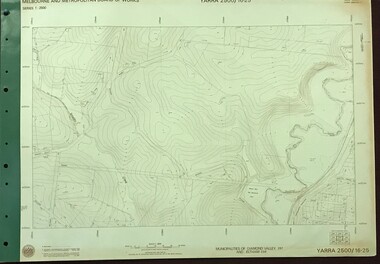
Map, Melbourne and Metropolitan Board of Works. Survey Division, MMBW, Yarra 2500 / 16.25. Wattle Glen, 1978_07
Melbourne and Metropolitan Board of Works. Yarra 2500 [base map] 16-25. Wattle Glen. Municipalities of Diamond Valley 257 and Eltham 238. Prominent streets include: Nimmo Road, Broad Gully Road and Heidelberg-Kinglake Road. Includes Yulong Park.MMBW Map in 1:2500 [scale] series. Cream parchment with green tape reinforcing on edges and punched holes on left edge.mmbw, melbourne and metropolitan board of works, shire of diamond valley, wattle glen - maps -
 Greensborough Historical Society
Map, Melbourne and Metropolitan Board of Works. Survey Division, MMBW, Yarra 2500 / 13.26. Yarrambat, Worns Lane, 1978_02
Melbourne and Metropolitan Board of Works. Yarra 2500 [base map] 13.26. Yarrambat, Worns Lane. Municipalities of Diamond Valley 257 and Whittlesea 239. Prominent streets include: Worns Road, North Oatlands Road and Licola Street. Features include Plenty River.MMBW Map in 1:2500 [scale] series. Cream parchment with green tape reinforcing on edges and punched holes on left edge.mmbw, melbourne and metropolitan board of works, shire of diamond valley, whttlesea, yarrambat - maps -
 Greensborough Historical Society
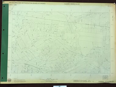
Map, Melbourne and Metropolitan Board of Works. Survey Division, MMBW, Yarra 2500 / 14.20. Montmorency, Sherbourne Road, 1977_06
Melbourne and Metropolitan Board of Works. Yarra 2500 [base map] 14.20. Montmorency, Sherbourne Road. Municipality of Diamond Valley 257 and Eltham 238. Prominent streets: Sherbourne Road, Karingal Drive and Calrossie Avenue. Features include Montmorency Station and Meruka Park.MMBW Map in 1:2500 [scale] series. Cream parchment with green tape reinforcing on edges and punched holes on left edge.mmbw, melbourne and metropolitan board of works, shire of diamond valley, montmorency - maps -
 National Vietnam Veterans Museum (NVVM)
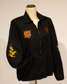
Memorabilia - Jacket, embroidered
Local tailors made these jackets with variations of the city name on the back: Vung Tau, Saigon, Vietnam. This item was purchased and worn by Lance-Corporal Ronald J Stibbe of the Royal Australian Engineers, who served in 1st Field Squadron in Vietnam from 21 Oct 1966 until 10 Oct 1967.Black cotton souvenir jacket with collar and front zip closure. On the back is a map of Vietnam with cities labelled, all in coloured embroidery. Above and below the map is white lettering. The upper sleeves of the jacket are embroidered with a dragon, whilst the front of the jacket features an embroidered tiger head and good luck symbol. It is lined with white silk.Adhesive tag "RJ Stibbe" Embroidered On back - 'WHEN I DIE I'LL GO TO HEAVEN BECAUSE / I'VE SPENT MY TIME IN HELL / SAIGON'. Below the map embroidered in white the lettering, 'VIET NAM - 66 67'.jacket, vietnam, souvenir, embroidered, stibbe, r j stibbe, anti-war, vietnam war, 1200492, bomber jacket -
 Tatura Irrigation & Wartime Camps Museum
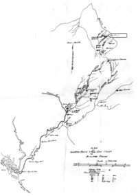
Map - Map - Photocopy, New Guinea Escape Route
At the end of January 1942 there was only about 250 men left in Wau, as the women and children had been evacuated by air a little earlier. With no planes to take the men they had to make their own way to Port Moresby and then travel by ship to Australia. Some men went down to Salamaua and made their way along the north coast, but small groups also made their way over the Owen Stanley Ranges; rafting down the Lakekamu RIver to Yule Island and by boat to Port Moresby. Donor Vanessa Kiessling's Father was part of the second group, and had drawn a detailed map of their route. This might be the same route taken by Rev. Willi Hertle (Ref C0750)Photocopy of New Guinea map showing escape routePlan of surveyed route from Edie Creek to Bulldog Dromepapua new guinea, escape, map, wau, willi hertle, kiessling -
 Ballarat Tramway Museum
Administrative record, State Electricity Commission of Victoria (SECV), "Queen Mother's visit - Tramway Arrangements", March 1958
Set of documents regarding the visit of the Queen Mother to Ballarat for the Begonia Festival on 2 March 1958. Comprises: 1 - SEC tramway arrangements - giving tramcar termination and restarting while the visit occurred 2 - Multiple copies of the Begonia Festival programme and the Music for the People event 3 - Letter from D I Graham thanking all those involved on Begonia Festival letterhead dated 7/4/1958 4 - Greater Ballarat map - with tram notes along the top edge. 5 - three page handwritten notes regarding tram arrangements, inspectors, and other notes.Yields information about the 1958 visit by the Queen Mother.Administrative record or documents - 8 sheets, and one folded map.tramways, queen mother, begonia festival, royal visit, map -
 Ringwood and District Historical Society
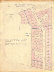
Map - Plan of Subdivision, Part of Crown Allotment 27 & 27B, Parish of Ringwood - (Undated, circa late 1950s)
Copy of land title map in manilla folder showing layout and size of 60 allotments in Railway Avenue, Victoria Street, Smithdene Avenue, Richard Court, Jeanette Court, Bruce Court and Loma Street, Ringwood East, Victoria.Note: Lot 15 is to be transferred to the Ringwood Borough Council for use as a children's playground. Map includes handwritten sales notations for several allotments, e.g. Sold. -
 Friends of Ballarat Botanical Gardens History Group
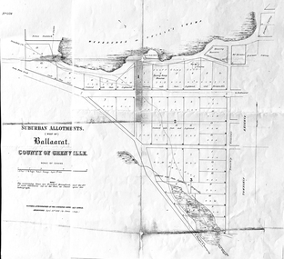
Work on paper - Suburban Allotments (west of) Ballaarat, Wendouree or Yuille's Swamp, County of Grenville 30/4/1856, 30/4/1856. No date given for photocopy
This map of the 1856 survey shows the numbered suburban allotments and the boundaries surrounding this area including Wendouree or Yuilles's Swamp close to where the Ballarat Botanical Gardens and the Lake exist today. This map gives a clear idea of an early survey of this western area and directions to areas of Ballarat surrounding these allotments.2 pages of the same map, except p.2 shows the Township Reserve on the lefthand side of the page. On the back of p.2, righthand corner is the Public Records Stamp.P2, righthand corner is the citation in pencil.john garner, doctor john garner, ballarat botanical gardens, friends of ballarat botanical gardens, map of western suburban allotments 1856, county of grenville, public record office of victoria, john garner collection, gardens, ballarat -
 Ballarat Tramway Museum
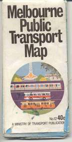
Map, Ministry of Transport, "Melbourne Public Transport Map" - "No. 12", 1982
Pocket size - folded - public transport map of Melbourne, printed in colour on paper, showing public transport services in greater Melbourne, including ticketing information, travelcards and an index of localities. The Central zone area shown in detail. On the rear, route numbers and line maps of tram routes and train lines or services and fare zones. The first map with the new three zone system of fares. Includes private bus routes. Printed 1982 by Government Printer. Issue No. 12.On inside, a circle route around Flinders, Queen, Little Collins and Swanston St in blue felt pen and arrow in blue ink. On the rear, a sketch map showing the location Charles St, Mantell St and William Road, and a circle around Upfield station.trams, tramways, melbourne, map, routes -
Tatura Irrigation & Wartime Camps Museum
Book, Emergence of Bioregionalism in the MD Basin, 1993
An exploratory essay on he ongoing history of Murray Darling Basin includes legacies, explorations, soil erosion, irrigation divsity, land degradation, change, regionalism, conservation, maps of Vic. NSW and QueenslandGloosy cover, brown marbled scenes from Berri Irrigation Area Reiver Murray, South Australia on back. Maps, water scenes, Pyap Estates on front.murray darling basin, legacies, erosion, degradation, diversity, tatura, murray river, books, rural, industry -
 Greensborough Historical Society
Map, Melbourne and Metropolitan Board of Works. Survey Division, MMBW, Yarra 2500 / 15.23. Diamond Creek Reserve, 1978_02
Melbourne and Metropolitan Board of Works. Yarra 2500 [base map] 15.23. Hurstbridge. Municipality of Diamond Valley 257. Prominent streets include: Challenger Street, James Cook Drive and Ryans Road / Main Street. Features include the Diamond Creek and Diamond Creek Reserve.MMBW Map in 1:2500 [scale] series. Cream parchment with green tape reinforcing on edges and punched holes on left edge.mmbw, melbourne and metropolitan board of works, shire of diamond valley, diamond creek - maps -
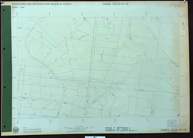 Greensborough Historical Society
Map, Melbourne and Metropolitan Board of Works. Survey Division, MMBW, Yarra 2500 / 14.25. Plenty, Heard Road, 1978_02
Melbourne and Metropolitan Board of Works. Yarra 2500 [base map] 14.25. Plenty, Heard Road. Parishes of Greensborough 2724, Nillumbik 3310 and Morang 3183. Municipality of Diamond Valley 257. Prominent streets include: Heard Road, Seymour Drive and Yan Yean Road.MMBW Map in 1:2500 [scale] series. Cream parchment with green tape reinforcing on edges and punched holes on left edge.mmbw, melbourne and metropolitan board of works, shire of diamond valley, plenty - maps -
Whitehorse Historical Society Inc.
Letter - Correspondence, Mullum Mullum Creek
Letter to the Minister of Land & Works from Richard R. Cross, George Hislop, Neil Faconer (sic) and Robert Leith .Letter to the Minister of Land & Works from Richard R. Cross, George Hislop, Neil Faconer (sic) and Robert Leith regarding a track through Crown Lands which has been applied for by Messrs. Logan and Galbraith. With map.Letter to the Minister of Land & Works from Richard R. Cross, George Hislop, Neil Faconer (sic) and Robert Leith .mullum mullum creek, roads and streets, cross, richard r., hislop, george, falconer, neil, leith, robert, warrandyte mitcham track, logan, galbraith -
Whitehorse Historical Society Inc.
Document, Australian Social History House Research Assignment, 1986
Social History of 2 Gordon Crescent, Blackburn,Social History of 2 Gordon Crescent, Blackburn, included - History of Blackburn, Architecture of the House and first owner, Thomas Richards Burrowes. Morton. Real Estate Brochures, Maps, Photos, Floor Plans.Social History of 2 Gordon Crescent, Blackburn, morton thomas richards burrowes, architecture -
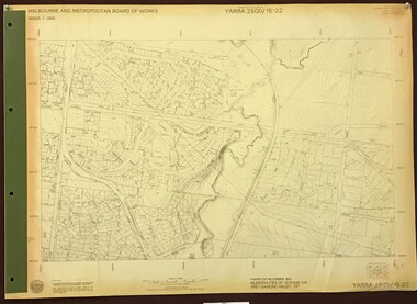 Greensborough Historical Society
Map, Melbourne and Metropolitan Board of Works. Survey Division, MMBW, Yarra 2500 / 15.22. Eltham North. Allendale Road, 1979_08
Melbourne and Metropolitan Board of Works. Yarra 2500 [base map] 15.22. Eltham North, Allendale Road. Parish of Nillumbik. Municipalities of Eltham 238 and Diamond Valley 257. Prominent streets include: Allendale Road, Godber Road and Ryans Road. Features include the Diamond Creek.MMBW Map in 1:2500 [scale] series. Cream parchment with green tape reinforcing on edges and punched holes on left edge.mmbw, melbourne and metropolitan board of works, shire of diamond valley, nillumbik, eltham - maps -
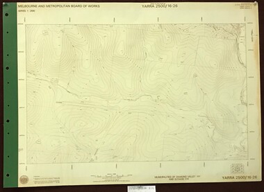 Greensborough Historical Society
Map, Melbourne and Metropolitan Board of Works. Survey Division, MMBW, Yarra 2500 / 16.26. Diamond Creek, Broadgully Road, 1978_07
Melbourne and Metropolitan Board of Works. Yarra 2500 [base map] 16.26. Diamond Creek, Broad Gully Road. Municipalities of Diamond Valley 257 and Eltham 238. Prominent streets include: Wadeson Road, Broad Gully Road and Glenhaven Road. Features include the Diamond Creek.MMBW Map in 1:2500 [scale] series. Cream parchment with green tape reinforcing on edges and punched holes on left edge.mmbw, melbourne and metropolitan board of works, shire of diamond valley, diamond creek - maps -
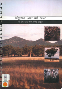 Victorian Aboriginal Corporation for Languages
Book, Elise Jeffery, Indigenous trees and shrubs of the west Port Phillip region, 2000
A series of information sheets on the west Port Phillip region, divided into zones, giving a guide to the tree and shrub species that occurred in those areas and where in the landscape they occurred.maps, b&w photographs, colour photographs, illustrations, word lists, wall mapindigenous plants, vegetation, species guide, revegetation -
Kew Historical Society Inc
Book, Donald Garden, Heidelberg : the land and its people, 1838-1900, 1972
Carlton, Victoria : Melbourne University Press, 1972 x, 219 pages : illustrations, maps, portraits, plates ; 23 cm non-fictionmelbourne --heidelberg to 1900, heidelberg (vic.) -- history. -
Kew Historical Society Inc
Book, Keith Cole, Letters from China 1893-1895: the story of the sister martyrs of Ku Cheng, 1988
Kew, Vic. : St. Hilary's Anglican Church, 1988 x, 136 p. : ill., map, ports. ; 21 cm. non-fictioneleanor saunders 1871-1895, elizabeth saunders 1873-1895, st hilary's anglican church -- kew -- (vic.), missionaries -- china -- biography -
Whitehorse Historical Society Inc.
Map, Township of Norwich, ca 1850
... maps ...Plan of the Township of Norwich being subdivision of Section III, Parish of Nunawading, County of Bourke, consisting of suburban farms, vineyard sites and town lots, for sale by auction by W. Casey & Co. [c. 1850]. Original in Vale Maps Collection, La Trobe Library.norwich village, vermont, parish of nunawading, vermont south, maps -
Tatura Irrigation & Wartime Camps Museum
Poster, Subdivision of Township Allotments
Poster depicting the land which was being sold by J S Darby on the 3 December 1890. Auctioneer was Martin Cussen and Co. Map shows location of land.Single sheet of paper, laminated. Advertising land subdivision for sale in the township of Rushworth. Being sold by Martin Cussen and Co, auctioneers for J S Darby. Shows map of land subdivision.rushworth, land subdivision, martin cussen and co, j s darby -
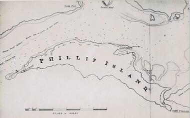 Phillip Island and District Historical Society Inc.
Photograph, Bryant West
... maps ...One of a collection of over 400 photographs in an album commenced in 1960 and presented to the Phillip Island & Westernport Historical Society by the Shire of Phillip IslandPhotograph of a Map of Phillip Island. The first to show Fort Dumaresq, track to beach and beginning of road to South coast. local history, photography, photographs, exploration, maritime, documents, maps, phillip island, john jenner, bryant west -
Whitehorse Historical Society Inc.
Map, Facilities provided for you, 1970
... maps ...Map of the City of Nunawading showing main roads and reserves with numbers indicating location of Halls, Infant Welfare Centres, Elderly Citizens Clubrooms and other major Council facilities. Route of proposes Healesville Freeway marked.Map of the City of Nunawading showing main roads and reserves with numbers indicating location of Halls, Infant Welfare Centres, Elderly Citizens Clubrooms and other major Council facilities. Route of proposes Healesville Freeway marked.Map of the City of Nunawading showing main roads and reserves with numbers indicating location of Halls, Infant Welfare Centres, Elderly Citizens Clubrooms and other major Council facilities. Route of proposes Healesville Freeway marked.city of nunawading, maps, maternal and child health centres, senior citizens centres, healesville freeway, parks and reserves -
 City of Kingston
Pamphlet - Colour, Stillwell and Co, The Hill Estate, Highett, 1917
Sales plan for land in the suburb of Highett, bounded by Point Nepean Road and including Sandford Street, Turner Road, Alfred Street and Peace Street.The developing urban area of Highett within the City of Kingston. This land sale pamphlet illustrates the subdivision of land within the municipality and the changing demographic of the district as new houses are constructed close to infrastructure.Colour pamphlet advertising for sale at auction The Hill Estate, Highett. Incorporates a map of the estate bordered by Point Nepean Road and including Sandford Street, Turner Road, Alfred Street and Peace Street.Handwritten in grey pencil on subdivision map next to subdivisions 91, 92, 93, 106, 107 and 108: x Handwritten in grey pencil on back cover: The / Hill Estate / Highettland sales, estate, highett -
 Bacchus Marsh & District Historical Society
Map, Plan of part of the road district of Bacchus Marsh circa 1856-1862
Local government in much of Victoria including the Bacchus Marsh area began with the formation of 'local committees'. These local committees could make representations to a Central Road Board regarding plans for road construction. Road construction and maintenance were seen as the essential tasks of these early local government authorities. By 1856 the local committee in Bacchus Marsh was constituted as the Bacchus Marsh Road District. This entity continued until 1862 when the name changed to the Bacchus Marsh and Maddingley Road District. This new entity lasted until 1871 when the local government authority in accordance with new statewide legislation became known as the Shire of Bacchus Marsh. The title of this plan being a plan of 'a portion of the road district of Bacchus Marsh' suggests that the plan was produced sometime between 1856 and 1862. The main purpose of this map was to shown the irrigable land in the district and the sources from which water for irrigation could be drawn. Bacchus Marsh was an early irrigation district in Victoria. Irrigation trusts were formed in the 1880s and 1890s to manage irrigation districts. But this was the culmination of many years of earlier attempts to construct irrigation systems in the Bacchus Marsh area and create a system to manage irrigation more broadly. This map dating from around 1856-1862 is an important cartographic document which provides evidence of how the early planning for irrigation was developing in the Bacchus Marsh region.A single page paper map showing a plan of part of the road district of Bacchus Marsh. The map is pasted into a bound volume containing 76 maps or plans in total. High resolution digital image stored on BMDHS computer network. bacchus marsh victoria maps, bacchus marsh road district, local government, road districts, irrigation -
![Map, Liquidator's sale, 1896. [Woolpack Estate, Bacchus Marsh]](/media/collectors/5e461d8021ea67224c82f2a1/items/6779ee97032b72846b5995f2/item-media/6779ef33032b72846b599b30/item-fit-380x285.jpg) Bacchus Marsh & District Historical Society
Bacchus Marsh & District Historical SocietyMap, Liquidator's sale, 1896. [Woolpack Estate, Bacchus Marsh]
The Woolpack Estate was an area of land owned by various landowners in the Bacchus Marsh area since the early Colonial period of the 1840s. The area was located on the eastern side of the Bacchus Marsh township about 7 kilometers from the town. The Lerderderg River ran through part of the land and so did the Melbourne to Ballarat Road. The historic Woolpack Inn associated with James Crook was also located on this land. By 1896 150 acres of this land was under the control of liquidators for the Federal Bank of Australasia who instructed that the land be sub-divided and sold in lots by public auction. A successful sale was held on 24 June 1896. Most of the blocks of land were sold for higher than expected prices and most of the buyers were people from the town and district of Bacchus Marsh. The map includes various details about the land which is described on the map as an "important sale of rich alluvial irrigable flat land in the Bacchus Marsh Valley, and other properties". The auction was conducted by the local agents W. Anderson and Bence in conjunction with Pearce Brothers also of Bacchus Marsh.A single page paper map showing a plan of 150 acres of land from the Woolpack Estate to be sold in various lots in June 1896. Also shown on the map are lots for sale at Robinson's Farm on Coimadai Creek and allotments near Bacchus Marsh railway station, including lots on Government Road (East Maddingley Road), View Street and Government Road (Parwan Road). No scale provided. The map is pasted into a bound volume containing 76 maps or plans in total. High resolution digital image stored on BMDHS computer network. land sales bacchus marsh, bacchus marsh victoria maps, woolpack estate bacchus marsh victoria -
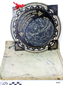 Flagstaff Hill Maritime Museum and Village
Planisphere, Early 20th Century
... maps ...The word Planisphere (Latin planisphaerium) was originally used in the second century by Claudius Ptolemy to describe the representation of a spherical Earth by a map drawn in the plane. This usage continued into the Renaissance: for example Gerardus Mercator described his 1569 world map as a Planisphere. The word describes the representation of the star-filled celestial sphere on the plane. The first star chart to have the name "Planisphere" was made in 1624 by Jacob Bartsch. Bartsch was the son-in-law of Johannes Kepler, discoverer of Kepler's laws of planetary motion. A significant item of celestial mapping used by marine navigators This particular item was made and used in the first quarter to half of the 20th centuryPlanisphere of northern hemisphere, with canvas bag. Planisphere consists of a circular star chart attached at its centre to an opaque circular overlay that has a clear elliptical window or hole so that only a portion of the sky map will be visible in the window or hole area at any given time. The chart and overlay are mounted so that they are free to rotate about a common pivot point at their centres. The star chart contains the brightest stars, constellations and (possibly) deep-sky objects visible from a particular latitude on Earth. The night sky that one sees from the Earth depends on whether the observer is in the northern or southern hemispheres and the latitude. A Planisphere window is designed for a particular latitude and will be accurate enough for a certain band either side of that. Planisphere makers will usually offer them in a number of versions for different latitudes. Planispheres only show the stars visible from the observer's latitude; stars below the horizon are not included. A complete twenty-four-hour time cycle is marked on the rim of the overlay. A full twelve months of calendar dates are marked on the rim of the starchart. The window is marked to show the direction of the eastern and western horizons. The disc and overlay are adjusted so that the observer's local time of day on the overlay corresponds to that day's date on the star chart disc. The portion of the star chart visible in the window then represents (with a distortion because it is a flat surface representing a spherical volume) the distribution of stars in the sky at that moment for the Planispheres designed location. Users hold the Planisphere above their head with the eastern and western horizons correctly aligned to match the chart to actual star positions. "Made in Germany for GEORGE PHILIP & SONS Ltd. Geographical and Educational Depot, 32 Fleet Street, London" Canvas bag has "Capt. H (Howard) Tyler from Captain H. F. Woolf" "Tyler 22 ? St East Brighton" also "13 Halls St Flinders"flagstaff hill, warrnambool, shipwrecked-coast, flagstaff-hill, flagstaff-hill-maritime-museum, maritime-museum, shipwreck-coast, flagstaff-hill-maritime-village, planisphere, star map, marine navigation, maps, george philip & sons -
 Greensborough Historical Society
Map, Melbourne and Metropolitan Board of Works. Survey Division, MMBW, Yarra 2500 / 14.21. St Helena, Weidlich Road, 1979_08
Melbourne and Metropolitan Board of Works. Yarra 2500 [base map] 14.21. St Helena, Weidlich Road. Parish of Nillumbik 3310. Municipality of Diamond Valley 257. Prominent streets St Helena Road, Weidlich Road, Karingal Drive and Progress Road. Features include the Blair Reserve.MMBW Map in 1:2500 [scale] series. Cream parchment with green tape reinforcing on edges and punched holes on left edge.mmbw, melbourne and metropolitan board of works, shire of diamond valley, st helena - maps -
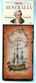 Orbost & District Historical Society
map, Shell Australia, 1970
This Shell road map was made as part of the 200 year celebration of Captain James Cook's voyage on the HM Endeavour and the first sighting of Australia at Point Hicks in 1770. The Bicentenary of James Cook in Australia was commemorated in Australia in 1970. The British explorer Lieutenant (later Captain) James Cook sailed and charted the East Coast of Australia in 1770, and claimed the eastern seaboard of the Continent for the British Crown. This was not considered the official bicentenary of Australia, but rather the mapping of the Eastern coastline. This item reflects the commemoration of a significant event in Australian history.A coloured foldout touring map of Australia with a picture of James Cook and the ship, Endeavour, on the front.map-australia bicentennial-cook-1970