Showing 2791 items
matching country victoria
-
 Kiewa Valley Historical Society
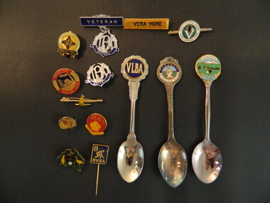
Medals & Spoons - Tawonga Bowling Club
Tawonga Bowling Club is well established with many local men and women involved. Bowling is a popular sport enabling locals to socialise and compete with each other and visit other clubs. Players formed teams representing the Tawonga Club and traveled to other clubs and on occasion represented their area eg. Nth East VictoriaVera Hore lived in Tawonga in the Kiewa Valley and was a prominent member of the Tawonga Bowling Club.5 silver spoons - 4 Tawonga Bowling Club with coloured picture on handle end. The 5th has 'Vera' on the handle end. 11 badges of varying shapes and colours all with pins, 2 silver, rest gold, 1 Ballarat, 1 Yallourn, 1 Bendigo, 6 Victoria, 1 Veteran and 1 'Vera Hore'tawonga bowling club, tawonga, vera hore -
 Kiewa Valley Historical Society
Photographs – Kiewa Cres Mt Beauty. Circa 1993. Set of 12 colour photographs, circa 1993
Established in 1946, during the construction of the Kiewa Hydro Electric Scheme, the township of Mt Beauty was developed by the State Electricity Commission of Victoria to provide additional accommodation for the thousands of workers during the construction of the country’s second largest hydro-electricity scheme. Although these towns were built as temporary accommodation for the workers and their families, many stayed after the scheme finished. Combined with the influx of European migrants, with their rich cultural backgrounds, all played a major part in shaping the future character of the Mount Beauty, the Kiewa Valley and Falls Creek. The Bright Council, now the Alpine Shire took over the control of the township in 1960. This relatively young town of Mount Beauty, along with the surrounding townships of Falls Creek, Bogong, Tawonga South and Tawonga, are all part of a prospering tourist area with excellent services, accommodation, food and a wide range of recreational activities available for all ages. According to Shire records, the population of Mt Beauty has grown from 1,500 in 1981 to 1,800 in 2016 with a projected increase to 2,000 in 2013The photographs taken around 1993 show a prosperous commercial centre catering for both locals and the needs of visitors. It provides a pictorial history of the changes which have occurred in the retail/commercial district of Mt Beauty over the years. It also demonstrates the attention paid by Alpine Shire towards providing accessible recreational green space around the town centre.Set of 12 colour photographs Kiewa Cres Mt Beauty. Circa 1993 showing retail services and streetscape of the time. No markingskiewa crescent mt beauty; shopping centre; -
 Kiewa Valley Historical Society
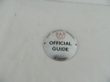
Badge -State Electricity of Victoria, Official Guide Badge
This is a badge which was worn by the official guides who led tours of the Kiewa Hydro Electric Scheme.This badge was issued by the State Electricity Commission of Victoria for use within the Kiewa Hydro Electric Scheme.Circular Metal disc with a large safety pin attached at the top of the back.In black print: State Electricity Commission/ SECV logo (in red) / Official Guide/ of Victoriastate electricity commission of victoria; guides; tours; kiewa hydro electric scheme -
 Kiewa Valley Historical Society
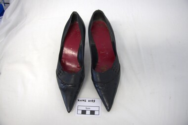
Shoes - Fashion, c1950s
Ladies fashion shoes made in Fitzroy by Ivan Porter of Goold & Porter Pty Ltd, during the 1940s and 1950s.Worn by Doris Melbourne, wife of Arthur, who worked for the State Electricity Commission of Victoria. They would have attended the many social events that took place in Bogong and Mt Beauty during the construction of the Kiewa Hydro Electric Scheme. They lived at Lower Bogong where the steps of their house can still be seen and later, at Bogong Village and Mount BeautyLadies fashion shoes, black, leather and latex with red insole and resin sole, pointed toes, low stiletto heels. Size 4 Three looped narrow black bands joining front and side of the shoe on the outer edge of each shoeBy Ivan porter'Made by/ Goold & Porter Pty Ltd./ Leather & Latex/ Insole/ Resin Sole (Size) 4 is indented on the sole between the toe and heelfashion shoes; lower bogong; secv; goold & porter shoe manufacturers -
 Kiewa Valley Historical Society
Papers - Edmondson's Hut, The letter is dated 8th October 1974
Edmondson's Hut is a cattleman's hut on the Bogong High Plains. Jim Edmondson obtained Run 33 (near Mt Nelse) in the early 1930s. He pre cut the timber at his property in Tawonga and along with iron for the walls, chimney and roof took it up to the Bogong High Plains on pack horse. The hut's wall and ceiling were lined and the hut had a 'fairly good floor and bunks'. In 1971 the hut was donated to the Education Department and was approved for transfer by the Lands Department in 1974. Bogong Outdoor School camp has been using the hut for students to camp in as well as National Fitness parties when walking in the area. The upper Kiewa Valley was settled from the mid 1860s and from its earliest days cattle were taken on to the Bogong High Plains to graze during summer. Jim Edmondson took his cattle from the Kiewa Valley to Mt Fainter and later to Run 33, near Mt Nelse. His hut is significant in the history of Cattlemen's huts on the Bogong High Plains.Four A4 typed sheets on white paper - 1. Acknowledgement of transfer of Edmondson's Hut. 2. History of Visitors (to the hut) Prior to 1971. 3. Two poems. 4. One poem 1. Emblem of Education Dept. Centre top of page. Addressed to James Edmondson, Tawonga, Victoria. 2. Page headed History and Visitors prior 1971. 3. My Old black Poley Cow (and) Roper's Track. 4. So Long, Mates!education department. edmondson's hut. bogong high plains. cattlemen. poetry. cattleman hut. bush walking. -
 Kiewa Valley Historical Society
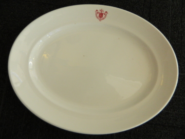
Plate - SECV dinner plates x2
The SECV had chalets, cafes, mess halls and tea rooms all over Victoria including their construction sites. The SECV had a stores system which purchased thousands of sets of crockery & cutlery for use by personnel. there was a system of chefs, cooks, tea persons etc. to supply food and beverages to the workers. 1921 signified the year the SECV was formed.This dinner plate was used at one of the sites on the Kiewa Hydro Electric Scheme which began construction in 1938 and concluded in 1961. Heavy white ceramic oval plate with State Electricity Commission of Victoria 1921 logo/insignia on the inside of one edge - middle of the long side of the plate. On the base, also inscribed in red are details of the makers.State Electricity Commission of Victoria / 1921. On the base: Vitrified / Sold by/ Cafe and Hotel Supplies / Pty. Ltd./ DunnBennett & Co. ITC / Burslem / Made in Englandstate electricity commission of victoria, dinner plate, crockery, kiewa hydro electric scheme, mess hall, mt beauty chalet -
 Kiewa Valley Historical Society
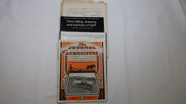
Journals - Department of Agriculture, 1. 1950s and 2. one 1932 & others 1970s
The Kiewa Valley has been a farming district from early settlement of white people. This has continued until the present although the nature of farming has varied over the years. Access to information has improved with transport and technology. The journals kept the farmers informed and up to date.These booklets and journals were one of the few sources of information during the 1950s for the isolated farmers of the Kiewa Valley. The Kiewa Hydro Electric Scheme improved both transport and technology during the scheme's construction from the 1940s. It provided the township of Mt Beauty at the upper end of the valley where shops and schools were constructed, roads were improved out of the valley and the supply of electricity for milking etc. became available. 1. 14 articles each bounded by 2 staples, and each reprinted from Dept. of Agriculture Journal on a particular topic relating to Agriculture. All black & white and c1950s. 2. 4 Journals with colored covers 3 from Victoria Dept. of Agriculture (1932, 1974 & 1975) and 1 from Sth. Australia.1. "J.H.Wallace" hand written top right corner of covers of pamphlets titled 'Diseases Affecting /Young Cattle' and 'Mastitis'. "AHW" hand written top right corner of cover of pamphlet titled ' Grading Land for Irrigation' 2. Nonefarming, agriculture, cattle, pasture, kiewa valley, department of agriculture in victoria, kiewa hydro electric scheme, -
 Kiewa Valley Historical Society
Papers - Falls Creek Tourist Area Management Committee, August 1984
Falls Creek is a ski resort in the north east of Victoria on the Bogong High Plains. Members of business's (accommodation & restaurants) formed the Falls Creek Chamber of Commerce to promote tourism 'under' the Falls Creek Tourist Area Management Committee. The Falls Creek Tourist Area Management Committee under the direction of the State Electric Commission of Victoria came into effect in 1959 and from then on building sites were leased and building and sewerage controls were applied. In 1979 the Victorian State Government had established the Ski Industry of Victoria working party with a brief report on its operation. These papers give an insight into the business of the Falls Creek Chamber of Commerce in 1984 eg. car parking, noise, closure of the resort due to heavy snow falls, the media and general development of the resort. Local business people are named as attending the meeting indicating many non English surnames. 4 yellowed papers typed on both sides of the first 3 pages. irst paper has 6 items listed re Falls Creek Chamber of Commerce / Sub Committee on General Booking Conditions.Dated 15th August 1984 Next 3 papers dated 13th August 1984 Falls Creek Chamber of Commerce / Minutes of General Meetingfalls creek, ski resort, bogong high plains, falls creek chamber of commerce, snow, ski lodges, -
 Kiewa Valley Historical Society
Book - Kiewa Voters' Roll, Shire of Bright - Voters' Roll 1979 - Kiewa Riding, 1979
Electoral rolls list people who are registered and eligible to vote at federal, state, territory & local government elections and referenda. Prior to 1990 the rolls list voters in alphabetical order by surnames & first names within each Sub division of an electoral division of each State or Territory. The roll is useful & interesting for family historians and the study of demographics. Alex McCullough lived in the Shire of Bright and was on its Council. Electoral roles help to locate the residential address of a person in a particular year or over a period of years. They can be used as a substitute for census records for family historians and the history of a particular place in this case the Kiewa Valley - Tawonga and Tawonga South.Approx. 60 pages of firm yellow paper with black typed print on one side only in 'landscape' format. Held by three staples. Each page has column - numbered 1 to 943; Surnames in alphabetical order; Given names; Occupation; includes L (=land). Address followed by Lot number and parish. Includes Tawonga and Tawonga SouthOn the cover on the right hand side handwritten and difficult to read - "Jack? / Indi / Benambra / Nth Eastern / Division? of Dawson / 123 Victoria Rd. / Melbourne 3000"shire of bright; kiewa riding; voters roll; alex mccullough; tawonga; tawonga south -
 Kiewa Valley Historical Society
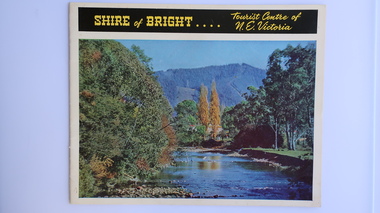
Brochure - Shire of Bright, Shire of Bright Tourist Centre of N.E. Victoria, Pre 1966
Bright and the surrounding towns were developing a large tourism industry which the Shire of Bright continues to promote, encouraging tourists to visit throughout the year. This high quality brochure has magnificent photos with a map showing the area and the distance (in miles) from the centre - the township of Bright.This brochure is promoting the Shire of Bright encouraging tourism in the area. This is important for the Shire as tourism is the main industry for the Shire. It is interesting to see how tourism has changed (or not) in the area.14 pages on glossy paper including colored and black and white photos. The front cover has the title at the top with yellow print on black background. Below the title is a large colored photo of a river, autumn trees and mountain. The back cover is a large colored photo of a man amongst the snow gums in the snow. The towns covered are Bright, Wandiligong, Eurobin, Mt Buffalo, McKay Creek Power Station, The Kiewa Hydro Electric Scheme, Mt Beauty, Kiewa, Bogong including tourist destinations in these areas and their surrounds.tourism; mt beauty; the kiewa valley; bright shire -
 Kiewa Valley Historical Society
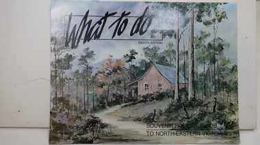
Brochure - Tourism, What to do - Souvenir Holiday Guide to North-Eastern Victoria
The Kiewa Valley has promoted itself as a tourist hot spot since the Kiewa Hydro Electric Scheme concluded. Mt Beauty began as a construction town and was to be sold off but tourism became promising so the SECV handed the town over to the Bright Shire, houses were sold and businesses commenced. From the early 1960s the town promoted itself and Falls Creek as a tourist destination. The Kiewa Valley Accommodation group combined with the local advertisers to publish this brochure.This brochure promotes tourism all year round promoting the local businesses enabling them to succeed. As tourism is the main industry in Mt Beauty and Falls Creek since the Kiewa Hydro Electric Scheme finished, this advertising is important. It is interesting to note the businesses - their type, their location and the comparison with those in the area now.19 black and white pages including maps and advertisements. Cover is a 'washed' color of a hut in the bush. The title is in black across the top and at the bottom right hand corner. The front cover is in 'landscape' format but the rest of the book is 'portrait'.mt beauty; falls creek; kiewa valley; tourism; north east victoria -
 Kiewa Valley Historical Society
Papers - Kiewa Hydro Electric Scheme, State Electricity Commission of Victoria / Kiewa Hydro Electric Project / Progress of the Undertaking, November 1953
The SECV constructed the KHES from 1939 to 1961 on the Bogong High Plains. It included work on Power Stations, Dams, Tunnels, Race-lines and transmission lines as well as camps, towns, roads, telecommunications and infra structure. These papers give an understanding of where the project was up to in late 1953. These papers give information on the KHES on the aspects of work, its progress and technical detail.3 foolscap pages, stapled in the top left hand corner. Each page has sub headings re the progress of the works being undertaken on the Kiewa Hydro Electric Scheme.state electricity commission of victoria; kiewa hydro electric scheme; power stations; dams; tunnels; bogong high plains -
 Kiewa Valley Historical Society
Booklet - Victoria's Hydro Power x2, Victoria's Hydro Power - SEC, August 1975
... Centre 31 Bogong High Plains Rd Mt Beauty high-country Booklet ...The State Electricity Commission of Victoria built several hydro power stations from 1928-1981. This book names each - up to 1975 - with a summary and explanation.The State Electricity Commission of Victoria built the Kiewa Hydro Electric Scheme which included the construction of Bogong Power Station, McKay Creek Power Station and West Kiewa Power Station. It also established infrastructure such as the townships of Bogong and Mt Beauty and the opportunity for tourism in the area Colored green/blue 'splash' of water on front cover with SEC logo in white centred under the yellow printed title. On the back cover is the SEC logo at the bottom in the middle.state electricity commission of victoria; kiewa hydro electric scheme; mckay creek power station; clover power station; west kiewa power station -
 Kiewa Valley Historical Society
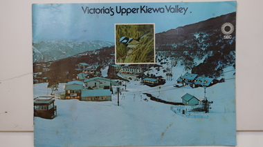
Booklet - SEC x2, 1. Victoria's Kiewa Valley 2. Victoria's Upper Kiewa Valley, No. 2 is dated October 1978
The State Electricity Commission of Victoria built the Kiewa Hydro Electric Scheme and was keen to promote tourism in the area. The booklet includes Facilities, Falls Creek Ski Resort, the Kiewa Works Area, the Three Floras of Bogong, the Geology of the Kiewa area, the Bird and Animal life of Bogong and the Kiewa Hydro Electric Scheme. The colored photos and the map on the back appeal to the reader/tourist.The SECV promoted tourism in the Kiewa Valley especially the area of the Kiewa Hydro Electric Scheme. This booklet is attractive and informative with a lot of detail. This proved to be the early stages of tourism in the area in what is now a very popular tourist destination and the main industry for the Upper Kiewa Valley.Blue cover with photo of Falls Creek at night. Title in black print at the centre top under which is an insert photo of a blue wren and SEC logo in white towards the top far right. Back cover is light green with a tourist map of the area. The text is complimented with brightly colored photos throughout.state electricity commission of victoria; kiewa hydro electric scheme; tourism; bogong; flora; fauna; geology; -
 Kiewa Valley Historical Society
Leaflet - Kiewa, Welcome to Kiewa
The State Electricity Commission of Victoria constructed the Kiewa Hydro Electric Scheme from 1938 to 1961. The Scheme included three power stations, dams, tunnels and was becoming a popular tourist destination with Falls Creek Ski field within its boundaries.This leaflet was published by the SECV to ensure all visitors to the Kiewa Hydro Electric Scheme were made aware of safety measures with regard to their driving and to bush fires. These were necessary as the area was unique with driving on mountainous roads, changeable and extreme weather and the threat of bush fires. The gatehouse existed during construction, when the SECV was in charge, as a restriction to entry to the Scheme for SECV workers and those with permission to enter. The SECV controlled the area so in case of accident, the SECV was the body to contact not eg. the police.Small white and green leaflet made from one sheet of glossy paper and folded in half. Front cover has the title in the middle, the SECV emblem at the centre top and across the bottom is a message to read the inside pages which are safety messages for driving and bush fires. The back cover has a RACV road map of Kiewa and its 'works' including the Gatehouse which was the entrance to the scheme.The map also has an insert of the main roads & nearby cities. state electricity commission of victoria; kiewa hydro electric scheme; gatehouse; safety rules; kiewa -
 Kiewa Valley Historical Society
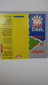
Brochure - Falls Creek Tourism, Falls Creek Never Out of Season
Falls Creek is a Ski Resort in the north east of Victoria. This brochure has been produced to encourage tourists to visit throughout the year.Tourism to the Kiewa Valley is an important industry for the area. Falls Creek is a ski resort with accommodation during winter for skiers, snow boarders and other snow sports. It involves entertainment, restaurants and associated workers. This brochure is produced to promote the resort throughout the year to increase the occupancy of these lodges. The tourist industry has increased steadily with fishing, cycling and bush walking increasing numbers in the area.Glossy square brochure folded in in half and half again. Front page is yellow on the left with black print on the far left. The right side has the title with blue, green and grey background with yellow, orange and white as part of the title. The back is a man standing in front of a sunset with print in a column towards the right side. Inside includes a map with advertisements for accommodation surrounding it.falls creek ski resort; alpine region in victoria; mountain lodges; -
 Kiewa Valley Historical Society
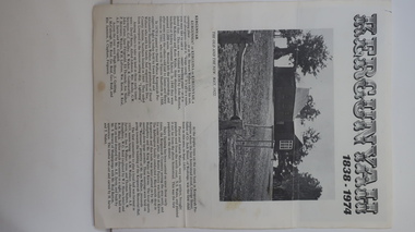
Leaflet - Kergunyah, Kergunyah 1838 - 1974, 1974
Kergunyah is a small town in the Kiewa Valley in north east Victoria. It is 10km south of Kiewa (town) and 23 km north of Dederang (town). it is farming country commencing in 1838, developing into a small community in 1974 with a School, Church, Post Office, Football Club, Young Farmer Club C.W.A. Netball Club, Card Club and Fire Brigade.Kergunyah is in the Kiewa Valley. Its history is important in the valley as it developed from a large pastoral run in 1838 into a small community supporting the local farming industry with essential organisations eg. school, fire brigade and social organisations eg. sporting teams, C.W.A.. Its history is significant as this leaflet has details of the organisations up to 1974 and this detail can be compared to organisations at Kergunyah today and can be compared to the history of other small rural communities. White stiff paper, folded to A4 size, with black and white photos on each of the 4 pages. Each page has detailed information under headings of community buildings and clubs in the small town. kergunyah; kiewa valley; small community; rural town; -
 Kiewa Valley Historical Society
Maps - Bogong x2, Tawonga, Omeo, Dargo, Victoria and others, 1. Bogong Alpine Area; 2. Bogong 8324; 3. Tawonga Topographical; 4. Omeo 8433; 5. Dargo 8323; 6. Victoria State
1. Bogong Alpine Area (outdoor Leisure Map. survey & Mapping Victoria, Government of Victoria, Edition 2, reprinted 1991 with an image of Mt. Feathertop on the front. Information for tourist in the Alpine National Park: Bogong Area. Including: recreational activities, history, weather and vegetation and a list of walks together with locality maps and photographs. The front cover has an image of Mt Feathertop against a blue sky with yellow writing 'Bogong Alpine Area', there is a yellow triangular block on the right hand top corner with black writing 'Outdoor Leisure Map. On the bottom edge is a block of yellow with black writing 'Survey & Mapping Victoria' and a light green map of Victoria with 'VICMSP' printed in white. 2. 8324 Bogong Victoria, Edition 1, Commonwealth of Australia 1981. A topographical Map: 1:100,000 scale (1 cm to 1 KM). Map has a red cover with white writing together with a white block and black writing and a map insert. 3. Tawonga Topographical Map - Forests Commission Victoria, / revised 5/9/77, DEG No. 68-G/399. A Tawonga 803 folded map in a beige colour with the back blank. 4. Omeo 8433 Victoria, Edition 1, Department of Natural Resources. The map has a red and white cover with black writing and a simple map of Australia at the bottom. 5. 8323 Dargo, Edition 1, Commonwealth of Australia. A red and white cover with a map insert. 6. Victoria State Map, Hema Maps, 2002. Hema Maps, State Map, colourful cover with a map of Australia and four tourism photographs. Scale 1: 850,000 An inscription handwritten in blue pen "Trappers Gap to Mitta Mitta 1" to 1 mile". There are some pen markings and notations of tracks.maps, bogong, omeo, tawonga, dargo, victoria, bogong alpine area -
 Kiewa Valley Historical Society
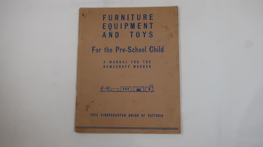
Book - Educational for Pre-School Child, Furniture, Equipment and Toys
Homemade toys were common in 1943.Mt Beauty's kindergarten had homemade toys.Faded cardboard cover with blue print on its front. 40 pages held by 2 staples on spine.'Furniture / Equipment / and Toys / For the Pre-School Child / A Manual for the / Homecraft worker / Picture of train / Free Kindergarten Union of Victoria' 1943mt beauty, kindergarten, toys, homemade equipment, pre-school -
 Kiewa Valley Historical Society
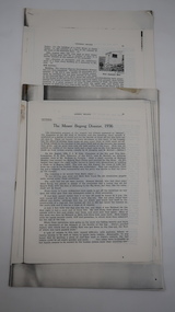
Papers - Mt Bogong (Two articles), Australian & New Zealand Ski Year Book: 1. Pages 91-94 and 2. Pages 45 -55
Mt Bogong is visited all year round. In 1936 Cleve Cole died after having been lost in a blizzard close to its summit. This resulted in the erection of snow poles and the Cleve Cole Hut.Mt Bogong, the highest mountain in Victoria, used by skiers in winter and bushwalkers in summer. The weather is variable.1. Article includes 'New Summit Hut' & includes effect of cattle on skiing conditions - 4 pages stapled top left corner 2. The Mt Bogong Disaster, 1936 Cleve Cole, Rescue. 10 pages stapled top left cornercleve cole, mt bogong, summit hut, snow, skiing disaster. -
 Kiewa Valley Historical Society
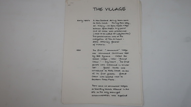
Papers - Falls Creek History, The Village
Timeline of Falls Creek during the 1950sFalls Creek is a snow resort on the Bogong High Plains, Victoria. The 1950s saw the village develop from its beginning to a popular ski resort.10 pages stapled top left corner. Includes a timeline of Falls Creek from early 1950s to the late 1950s. Titled 'The Village' and handwritten on one side only.falls creek, skiing, tourism, snow resort -
 Kiewa Valley Historical Society
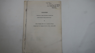
Memoir - Adrian Rufenacht, The Kiewa Project
Adrian Rufenacht, BCE (S.F.I.T. Zurich) MIE Aust. former Chief Civil Engineer of the State Electricity Commission of Victoria, retired 1967. Insight into the Kiewa Hydro Electric Scheme.First hand knowledge of the history of the Kewa Hydro Electric Scheme.40 pages stapled with 4 staples. The Kiewa Hydro Electric Scheme by Adrian Rufenacht, former civil engineer of SECV. Includes maps.On the front page - handwritten: 'To Ron / in memory of happy / and interesting times. / Adrianadrian rufenacht, khes, kiewa project, construction, secv -
 Kiewa Valley Historical Society
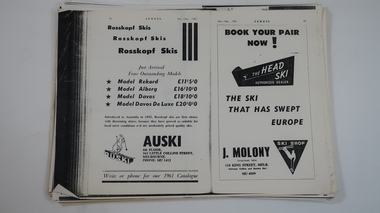
Papers - Skiing at Falls Creek
Skiing at Falls Creek from the 1940s has changed re - equipment, including eg. types of tows, gear and clothes. These pages give an insight into the 1960 and 1961 developments re accommodation, social scene, ads re equipment etc. and articles eg.on Tow-bar lifts, people, workers and tourists.Falls Creek, one of Victoria's most popular ski resorts, was developing quickly in the early 1960s. Photocopies of pages from 'Schuss' ski magazine 1960 and 1961 selected for the references to Falls Creek.falls creek, skiing, tourism -
 Kiewa Valley Historical Society
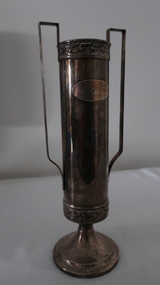
Trophy - Lieut. L.A. Heywood WWII and 58th Battalion
Lieut. L. A. Heywood was a Captain in 1945. The 58th Battalion was made up mostly of men from Victoria including Hume and was iniatially a militia unit before becoming part of the AIF in WWIIWWII and the connection of the 58th Battalion with local soldiers and possibly with L.A. HeywoodTall tarnished silver trophy with 'cup' base, small neck and long cylinder with a long straight handle on each side.On steel plate - inscribed "Presented by / Liut. L.A. Heywood / No 7 PL. 58th BN. / Awarded to / (blank)/ For best attendance / 1930 - 31" Under base: "Hecworth / E. P. (diamond shape) N.S."58th battalion, lieut. l.a. heywood -
 Kiewa Valley Historical Society
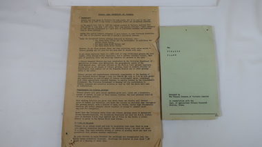
Papers - The Tobacco Industry
Tobacco in the Kiewa Valley. Tobacco was grown in Victoria for many years but the main areas (from the 1960s) included the Upper Kiewa River Valley where areas were suited. A Tobacco Research Station was established in Myrtleford, the geographical centre of the North Eastern tobacco growing area.Tobacco was grown successfully in the Kiewa Valley1. Leaflets x2 Green paper - 'The Tobacco Plant' Prepared by The Tobacco Growers of Victoira Limited in consultation with the Dept. of Agriculture Tobacco Research Station, Ovens. 1980s 2. papers yellowed and printed on both sides. - 'The Golden Leaf - The story of the tobacco leaf. Prepared by the Tobacco Growers of Victoria Ltd.' 1980stobacco, kiewa valley, agricultural farming -
 Kiewa Valley Historical Society
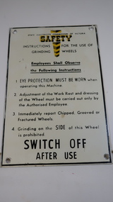
Sign - SECV, Safety - Grinding Wheels
The State Electricity Commission of Victoria produced and displayed safety signs for their employees during the construction of the Kiewa Hydro Electric Scheme.KHES was constructed from the late 1940s to early 1960s and included the construction of Mt Beauty and Bogong townships. Safety was a concern for the SECV towards its workers. Metal black print on white background with yellow 'emphasis' at the top - 'Safety'. "Instructions for the use of / Grinding Wheels". There is a circular hole in each corner with a black frame around the perimeter.state electricity commission of victoria, kiewa hydro electric scheme, safety sign, grinding wheels -
 Kiewa Valley Historical Society
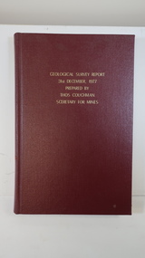
Book - Geographical Survey, Geographical Survey Report 31st Dec. 1977 prepared by Thos. Couchman Secretary for Mines
Office of Mines published progressive reports on the Geological Survey of parts of Victoria.This book includes a chapter on 'Dargo and Bogong' Pages 96 - 117 and includes a fold out map of this area. These pages show heavy use.Hard deep red cover with gold printed title located at the centre top. Bound with spine blank. 217 pages. Date 1878 First chapter and some pages have pencil marks including page 97.geological survey 1878, dargo, bogong -
 Kiewa Valley Historical Society
Book - Craft, Dressmaking Made Easy, 1958
... tawonga. country woman's association of victoria... for women and children in the country. This was achieved by getting ...Tawonga C.W.A. was involved in dressmaking and other home industries.The Tawonga branch of the C.W.A. commenced on the 7th Feb. 1946 and often combined activities with the other branches in the Kiewa Valley. The C.W.A. aimed to improve health, welfare and education for women and children in the country. This was achieved by getting together and exchanging ideas on dressmaking while providing for their families and the local community, possibly selling their products at fetes.Women living in Tawonga were mostly on farms and, in 1946, when the branch commenced would have been feeling more remote with WW11 having an effect on available workers and the well being of the women and children.Small white and grey book with picture of tape measure and cotton reel on the cover. It has 15 pages including the cover which is printed on too. It has general instructions for sewing. Held by 2 staplesCover: Woman's Realm presents / Dressmaking / made easy / Simple instructions and / step-by-step diagrams for / making your own clothes tawonga. country woman's association of victoria. dressmaking. woman's realm. c.w.a. -
 Kiewa Valley Historical Society
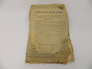
Papers - Kiewa Valley Rifle Club
Kiewa Valley Rifle Club belonged to the Australian Rifle Clubs. They were in Military District No. 304 and operated as early as the 1920's. In 1876 an Australian Rifle Team, consisting of shooters from N.S.W. and Victoria, was the first team ever to officially represent Australia in any sport in international competition. In 1885 the first civilian Rifle Club was formed. After 1901 all Rifle Clubs came under army control. In 1921, they were reconstituted as a purely civilian organisation where they have remained ever since.These papers are evidence that the Kiewa Valley Rifle Club existed from the 1920's, enabling its members to participate in a sport that had 12232 members and 313 Rifle Clubs in Victoria by 1939.Old yellowed torn papers titled Australian Rifle Clubs / Annual Return for the year ended 1929, 1934,1935, 1936, 1937, 1938, 1939, 1940, kiewa valley. rifle club. community -
 Kiewa Valley Historical Society
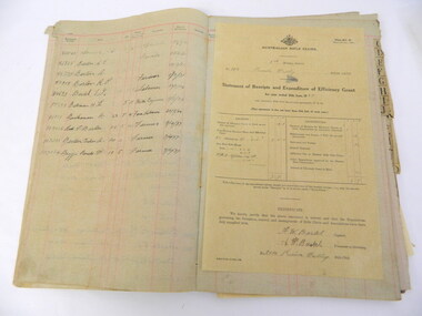
Ledger - Kiewa Valley Rifle Club
The Kiewa Valley Rifle Club belonged to the Australian Rifle Clubs. They were in Military district No. 304 and operated as early as the 1920s. In 1876 an Australian Rifle Team, consisting of shooters from N.S.W. and Victoria, was the first team ever to officially represent Australia in any sport in international competition. In 1885 the first civilian Rifle Club was formed and after 1901 Rifle Clubs came under army control. In 1921, they were reconstituted as a purely civilian organisation where they have remained ever since.This ledger is evidence that the Kiewa Valley Rifle Club existed in the 1920's and 1930's, enabling its members to participate in a sport that had 12232 members and 313 Rifle Clubs in Victoria by 1939.Large yellowed alphabetical ledger covering the 1920's and 1930's with names, age, height, occupation and date of enrolment. There are not many entries Inserted between pages are forms from the 'District Base Headquarters' with the headings filled out for - 'Name of New Member' and his 'Registration Number Allotted'rifle club. kiewa valley. ledger. community.