Showing 1557 items
matching e. s.
-
 Tatura Irrigation & Wartime Camps Museum
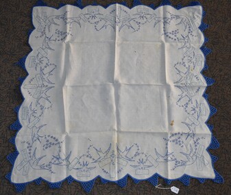
Domestic object - Tablecloth, Mrs Slender, 1920's - 1930's
Names included on cloth: Colliver, Whelpdale, E. Williams, Ms Lynch, Slender, Dowell, Corrigan, McDonald, Hutchinson, Loveden, Young, Hogan, Maher, Reilly, Fraser and Fahey.Square cotton tablecloth embroidered in blue silk, crocheted around edges. Fancy worked blue birds holding cards with local family names from reserve, south of Tatura,1920's - 1930's.local craftwork, cotton tablecloth, colliver, whelpdale, e williams, lynch, slender, dowell, corrigan, mcdonald, hutchinson, loveden, young, hogan, maher, reilly, fraser, fahey -
 Tatura Irrigation & Wartime Camps Museum
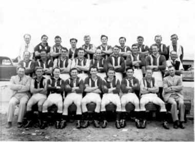
Photograph, Football Club Premiers 1952
Tatura Premiership Football Team, 1952.|Back row: C. Ryan, B. McHugh, T. Ryan, I. Bunn, T. Deane, W. Corrigan, J. Mactier, B. Young, K. Anderson, H. Parker.|Centre row: S. Vagg, K. Binion, P. Crawford, L. Joyce, V. McKenzie, R. Connors, F. Joyce, R. McDonald, B. Ransom.|Front row: J. Trevaskis, R. Warnett, R. Smith, R. Daly, W. Pritchard, D. Brown (cc), G. Kerrins, P. Warnett, E. Davies.|A local football team was in existence from about 1885, and it is interesting to note that the members were called the "Tatura Bohemians" in 1888!|In 1894, when D. Heaphy was the first President of Tatura Football Club, they joined the Goulburn Valley Football Association.|"Travel to distant matches was undertaken by horse and jinker, buggy and pair until Charlie Brady, the storekeeper, suggested that special trains be run and put up the guarantee" ...quote from W.H. Bossence "Tatura" history.|Tatura teams were Premiers in 1898, 1901-02, 1904-05, 1952-53.|Tom Hogan was the first local player to be offered a game in the city of Melbourne, soon followed by Archie Wilson.|Robert Mactier, V.C. had played football for Tatura before leaving for service in WW1.tatura, recreations, sports, costume, male -
 Tatura Irrigation & Wartime Camps Museum
Photograph, Tatura Lady Bowlers 1973
... . Blake, E. Evans, J. Stewart, L. McLeod, J. Sudholz, S.... Campbell, E. Butcher, E. Green, A. Todd, R. Huggins, P. Crawford, E ...Tatura Lady Bowlers, 9th January 1973.|Front row: J. Davies, M. Campbell, E. Butcher, E. Green, A. Todd, R. Huggins, P. Crawford, E. Dudley, D. Davies, M. Ducat, K. Mactier.|Middle row: M. Blake, E. Evans, J. Stewart, L. McLeod, J. Sudholz, S. Hetherington, M. Beckwith, E. Curtis, O. Daykin, F. Stammers, L. Dawson, H. McCracken, M. Wheeler, D. Maskell, D. Godbehere, F. Mason, A. Robbins, C. Uebergang, M. Leaf, A. Groom, R. Donaldson.|Back row: N. Smith, A. Hoffman, P. Bollard, D. Dunlop.tatura, recreations, sports, games, costume, female -
 Tatura Irrigation & Wartime Camps Museum
Box, Tatura & District Co-Operative Housing Society Ltd, 1964 - 1981
Applications for Co-Operative Housing Loans. - 1964 - 1981Dark brown and white archival boxandrews r, bear r, baldwin e, batey l, beer m, beqir t, boccabella a, boschetti p, brown j, bunn j, caiafa g, callaghan j, cassidy j, cleary p, clement r, corrigan v, cross d, doller h, downie t, draper r, elliott s, gale d, gledhill j, gledhill k, glover a, green d, greenaway i, gregory w, hepworth r, hoelter c, iorio c, kiss j, letizia f, lockwood r, matheson r, mcardle b, mcintyre f, mcleod b, mcmahon f, muto d, nash b, oliver r, pinner l, rogers a, ross s, serra a, sinclair j, trevaskis j, wall f, whiteacre g, willaton a, williams r, tatura, housing loans, documents, agreements -
Tatura Irrigation & Wartime Camps Museum
Photograph, D. Clark, Tatura Football Team 1946, Original 1946 copy 1989
Tatura 2nd 18 Sunday football team: B. Cummins, R. Connors, S. Chance, G. Revell, M. Dowell (goal umpire), M. Hogan, N. Colliver (trainer), B. Quinn, B. Alexander, E. (Ted) Normington, V. Cummins, M. Harding, M. Keating, A. McDonald, M. Huggard, P. Grant, G. Huggard, N. Williams, J. Corrigan.Black and white photograph of Tatura Football 2nd eighteen Sunday team 1946. Copy. Original 261.1.on back: Tatura 2nd 18, 1946 Sunday team. Names (see below). -
Tatura Irrigation & Wartime Camps Museum
Photograph - copy, D. Clark, H. S. Davy's Funeral, 1989 copy
Photograph of H. S. Davey's funeral. 9.2.27. Hearse belonging to C. J. Mitchell. C. J. and E. D. Mitchell sitting up front. H. S. Davey bought the Guardian Newspaper in 1906.Black and white copy photograph of funeral procession of H. S. Davey, Tatura. Victory Hall and Sacred Heart Church in background. 9 February 1927.on back: funeral procession of H. S. Davey 9.2.27. Other details below -
Tatura Irrigation & Wartime Camps Museum
Photograph - original, Kodak, F. E. Williams Store c 1920, 1920
original photograph of grocery window display, arranged and photographed by Frank Stevenson. Later to have his own grocery store. reflection of fire brigade station across the road. original sepia photograph of store grocery window display, F. E. Williams store. c 1920. Exterior.on back: F. E. Williams Shop. Grocery window display. c 1920. Arranged and photographed by Frank Stevenson 1920's. Reflection of fire brigade station.f. e. williams store -
Tatura Irrigation & Wartime Camps Museum
Photograph - copy, D. Clark, F. E. Williams Store c 1920, 1920 original 1989 copy
Copy of original photograph of grocery window display, arranged and photographed by Frank Stevenson. Later to have his own grocery store. reflection of fire brigade station across the road. Original photograph L0330Copy of original sepia photograph of store grocery window display, F. E. Williams store. c 1920. Exterior.on back: F. E. Williams Shop. Grocery window display. c 1920. Arranged and photographed by Frank Stevenson 1920's. Reflection of fire brigade station.f. e. williams store -
 Tatura Irrigation & Wartime Camps Museum
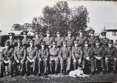
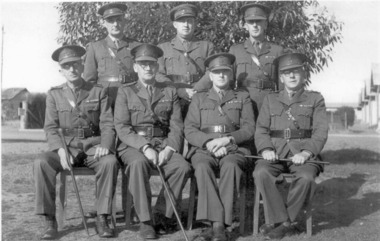
Photograph, Camp 1 Staff Officers, copy 1989 original 1942
WW2 internment camp 1, Tatura, Army officers of headquarters and A Company 17th garrison Battalion no 1 camp Tatura. 15 June 1943. Back row (l to r): Captain E A Scates; Lieutenants J A Travers, S H Edwards, J H Trend, C L White, Captain F G Jones, Lieutenants B A Stinson, L P Brown, A L Mackay. Front row: Lieutenant E K Horwood, Captain W A A Tyler, Captain N E Bacon, Major A H Clerke, Captain G B Russell, Lieutenant Colonel F W D Forbes, Major G E Blight, Major E C Foster, Major J Morlet, Captain A E OwensGroup of 19 Army staff officers in uniform. Hut rear right. Tree background. Black and white hound dog foreground.internment camps, tatura internment camps, internment camp army staff, staff officers, captain e a scates, lieutenant j a travers, lieutenant s h edwards, lieutenand j h trend, lieutenant c l white, captain f g jones, lieutenant b a stinson, lieutenant l p brown, lieutenant a l mackay, lieutenant e k horwood, captain w a a tyler, captain n e bacon, major a h clerke, captain g b russell, lieutenant colonial f w d forbes, major g e blight, major e c foster, major j morlet, captain a e owens -
Tatura Irrigation & Wartime Camps Museum
Poster, Guardian Print, Tatura and Kyabram, Gala Dance, 1950's
Associated with the Kindergarten, Francis Street, Tatura building appeal of early 1950's. Dancing and Euchre.Poster advertising "Gala Dance" and euchre party in aid of Tatura Kindergarten building appeal. Printed by The Guardian with red ink. Admission 7/6. Advertisements from L. H. Collison and H. E. Blake.tatura kindergarten -
 Tatura Irrigation & Wartime Camps Museum
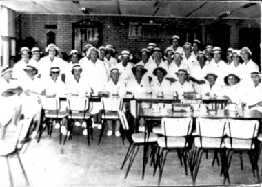
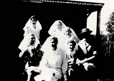
Photograph, AWAS Sisters
AWAS sisters from Tatura Group internment camps. Rear: Sisters S O'Shannessy, M Morrison and E Chalmers. Seated: Sisters Robinson, D Evans, M Peck and Lorraine Danson.Black and white photograph of 7 nursing sisters, 3 standing, 4 seated, in uniform. Building behind them and a tree on the far right. Sister on right has a hat on.sister o'shannessy, sister morrison, sister chalmers, sister robinson, sister evans, sister peck, sister lorraine danson, awas -
 City of Ballarat
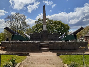
Artwork, other - Public Memorial, Eureka Monument, 1923
... . Haynes, P. Gittins, T. Mullins, S. Green, R. Julien, E. Thonen, J.... Mullins, S. Green, R. Julien, E. Thonen, J. Hassle. Soldiers ...HistoricA sandstone plinth with tablet commemorating the Eureka Stockade Rebellion of December 3, 1854 including the names of diggers and soldiers whom fought and fell in battle, surrounded by a bluestone border. Set on a larger platform surrounded by four cannons and bluestone edge. Set in parkland with entry gateway at Eureka Street, Ballarat.Eureka Stockade Sunday Morning December 3rd 1854. This tablet was created by the Eureka Improvement Committee 1923. To honour the memory of the Heroic Pioneers who fought and fell, on this Sacred spot, in the cause of liberty. And the Soldiers who fell at Duty's call. Diggers: W. Emmerman, J. Diamond, T. O'Neill, J. Donaghey, W. Clifton, E. Quin, W. Quinlan, J. Hafele, J. Crowe, T. Moore, J. Brown, Lieut. Ross, J. Robertson, Fenton, E. McGlyn, J. Haynes, P. Gittins, T. Mullins, S. Green, R. Julien, E. Thonen, J. Hassle. Soldiers: Capt. H.C. Wise, Ptes. W. Webb, M. Roney, J. Wall, F. Boyle, J. Hall.eureka -
 City of Ballarat
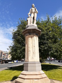
Sculpture - Public Artwork, George Grant, Thomas Moore Memorial Statue George Grant, 1889
Irish poet and balladeer Thomas Moore, best-known for penning The Minstrel Boy and The Last Rose of Summer, is honored in this statue prominently located in Sturt Street created by sculptor George Grant from white Carrara marble. George Grant was trained at the School of Art associated with the National Gallery of Victoria, apparently in the 1880s, and then worked as an artist, specialist house painter, and banner artist. Several of his paintings are held by the Ballarat Art Gallery. Moore`s writings range from lyric to satire, from prose romance to history and biography. His popular "Irish Melodies" appeared in ten parts between 1807 and 1835. Moore was a good musician and skillful writer of songs, which he set to Irish tunes, mainly of the 18th century. This statue is of historic and aesthetic significance to the people of Ballarat.Marble statue of Thomas Moore above a large sandstone pillar West: Presented to the City Council of Ballaarat by the following citizens: H.F. Elliot, The Honorable E. Morey M.L.C., Cr C.R. Retallick, Cr J. Heinz. South: R.S. Mitchell, P. Papenhagen, T. Elliot, J. Snow, G.K. Coutts, C. Bailey, J.J. Goller & Co, W.E. Ballhausen, G. Thompson, W.H. Figgis. North: S. Seward, F.G. Haymes, Craig Williamson, R. Giddings, G. Berry, R. Inge, J.A. Pittard, L. Lederman, H. Bremer, D. Jones. thomas moore -
 Wangaratta RSL Sub Branch
Photograph, c1945
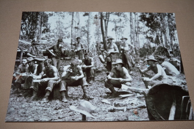
SATTELBERG AREA, NEW GUINEA. 1943-11-15. TROOPS OF THE 2/24TH. AUSTRALIAN INFANTRY BATTALION EATING MEAL DURING A LULL IN THE BATTLE FOR SATTELBERG. THEY ARE: NX10044 ACTING SERGEANT Stewart COLDHAM. (1) VX68432 PRIVATE Harold ANQUETAL. (2) VX80603 PRIVATE Thomas. F. BRYCE. (3) VX41167 PRIVATE Samuel T. SHERLOCK. (4) VX28432 LANCE CORPORAL Kenneth G. NORRIS. (5) ACTING CORPORAL Ralph F. KENYON. (6) VX43055 SIGNALMAN Ernest W. HORNER. (7) NX33751 PRIVATE Arol. J. PEIRCY. (8) VX71588 SIGNALMAN Francis. J. KELLY. (9) VX26381 PRIVATE John BUNNETT. NX86910 SIGNALMAN Ronald E. AMERY. QX13958 SERGEANT James S. GREGORY. SX30255 PRIVATE Cyril MARSHALL VX29721 SIGNALMAN Martin W. REIDY.The 2/24th Battalion was an infantry battalion of the Australian Army, which served during World War II .A unit of all-volunteers, it was formed in July 1940 from primarily Victorian volunteers and was known as "Wangaratta's Own" because of the time the battalion spent in the town during its formative period prior to deployment overseas. It served in North Africa in 1941–1942 as part of the 26th Brigade, which was assigned to the 7th Division, before being reassigned to the 9th Division. In early 1943, the battalion returned to Australia and later took part in campaigns against the Japanese in New Guinea in 1943–1944 and Borneo in 1945, before being disbanded in 1946. The 2/24th suffered the highest number of casualties of any 2nd AIF infantry battalion. The Unit was granted the Freedom of the City by the Rural City of Wangaratta in 1990 and one of the first, if not the first, to receive this type of honourReproduced black and white photograph of large group of soldiers having a meal. Soldiers are seated in the foreground and five standing behind. Nearly all have shirts removed.2/24th battalion, new guinea, ww2 -
 Wangaratta RSL Sub Branch
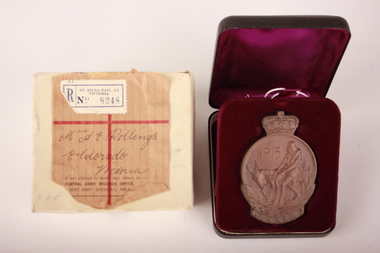
Anzac Commemorative Medallion and Box, Raymond Ewers, 1967
Anzac commemorative medallion issued to the next of kin of Private Thomas Emanuel Rollings - 1983 - 24th Battalion, Wangaratta. See also 213. The Anzac Commemorative Medallion was instituted 1967. It was awarded to surviving members of the Australian forces who served on the Gallipoli Peninsula, or in direct support of the operations from close off shore, at any time during the period from the first Anzac Day in April 1915 to the date of final evacuation in January 1916.Bronze commemorative medallion depicting Simpson and his donkey on the front and Australia, New Zealand and the southern cross on the back.Medallion is set inside a plastic hinged lid box with a deep purple velvet lining. Original white cardboard box with two sections. Top section has brown paper label with handwritten address and white/blue stamp on outside. The medallion is cast in bronze and is approximately 75 millimetres high and 50 millimetres wide. The obverse of the medallion depicts Simpson and his donkey carrying a wounded soldier to safety. It is bordered on the lower half by a laurel wreath above the word ANZAC. The reverse shows a map in relief of Australia and New Zealand superimposed by the Southern Cross. The lower half is bordered by New Zealand fern leaves. The name and initials of the recipient is engraved on the reverse. The medallion is issued in a presentation box.Medallion - Front: "1915" "ANZAC" Back: "T. E. ROLLINGS" hand engraving Cardboard box - Top section: "St Kilda Rail., S.2 / Victoria / No. 8248"printed "Mrs A E Rollings / Eldorado / Victoria" handwritten "If not claimed in seven days return to :- Central Army Records Office, Albert Park Barracks, Melb" anzac, medallion, commemorative medallion, bronze, eldorado, 24th battalion, wangaratta, gallipoli, ww1 -
Tatura Irrigation & Wartime Camps Museum
Photograph, Premiership Football Team
Premiership Football Team. Back Row : C.Ryan, B McHugh, T Ryan, I Bunn, T Deane,W Corrigan, J Mactier, B Young, K Anderson, H Parker Centre Row: S Vagg, K Binion, P Crawford, L Joyce, V McKenzie, R Connors, F Joyce, R McDonald,B Ransom. Front Row: J Trevaskis, R Warnett, R Smith, R Daly, W Pritchard, D Brown ( c.c.) P Kerrins, P Warnett, E Davies -
 Tatura Irrigation & Wartime Camps Museum
Photograph, Camp 1 Garrison
Army officers of A Company, 17th Garrison Battalion, No Camp 1 Tatura. (2 different size photographs) Front row (l to r): Lieutenant J A Frances, Lieutenant Cyril Leyshon White MM, Major E C Foster MC, Captain E A Scates Back row (l to r): Lieutenant S H Edwards, Lieutenant I H Trend, Lieutenant L F Brown.Black and white photograph of 7 officers in full uniform, (3 standing, 4 sitting). Tree directly behind them. Buildings can be seen on either side in backgroundlieutenant s h edwards, lieutenant trend, lieutenant brown, captain scates, camp 1 officers, lieutenant j a frances, lieutenant cyril leyshon white, major e c foster, 17th garrison battalion -
 Uniting Church Archives - Synod of Victoria
Certificate - Methodist Girls' Comradeship, Charter
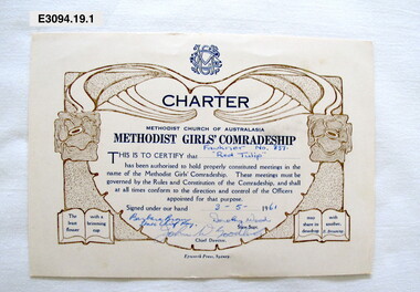
The Methodist Girls' Comradeship was formed in 1918 with the first Branch being in Bondi, NSW. There were three sections: Junior Rays, 8 - 11 years; Senior Rays, 11 - 15 years and Comrades, 15 years and over. The aims of the MGC was to "challenge young people with the saving power of Jesus Christ and provide avenues of christian service" and "to provide for the spiritual, social, physical and educational welfare of the members". The MGC's motto was "The Utmost for the Highest".Six cream coloured charters with blue and gold print and handwritten information. E3094.19.1 Fawkner No 337; E3094.19.2 Snow Myrtle No 369; E3094.19.3 Traveller's Joy No 292; E3094.19.4 Box Hill No 391; E3094.19.5 Ivy Leaf No 396 and E3094.19.6 West Newport No 325.E3094.19.1 "Fawkner No. 337 Red Tulip 3-5-61 Barbara Brown State Chief Ray Dorothy Waod John W Goodluck" "E3094.19.2 ""SNOW MYRTLE" BRANCH NO 369 12th march 63 S.P.Arhur S.C.R. Margaret Nevitt John W Goodluck" E3094.19.3 "Traveller's Joy Branch No 292 6th May 58 J Green" E3094.19.4 "Box Hill no.391 "Sunflower" 26th March 65 Norma E Pearce STATE CHIEF RAY Beverley J. Lowe" E3094.19.5 "Ivy Leaf Branch No. 396 26-4-65 Beverley J. Lowe Bruce Rollins" E3094.19.6 "Chrysantemum Rays' Branch Wes Newport No.325 24-5-60 Barbara Brown State Chief Ray Dorothy Wood Graeme W Speedy"methodist girls' comradeship, methodist girls' comradeship rays' section, charters, methodist church of australasia, youth groups, barbara brown state chief ray, graeme w speedy chief director, beverley j lowe state supt., bruce rollins chief director, ivy leaf branch no 396, chrysanthemum west newport no 325, norma e pearce state chief ray, sunflower box hill no 391, traveller's joy no 292, j green state supt., snow myrtle no 369, s p arthur state chief ray, margaret nevitt state supt., john w goodluck chief director, dorothy wood state supt., red tulip fawkner no 337 -
 Robin Boyd Foundation
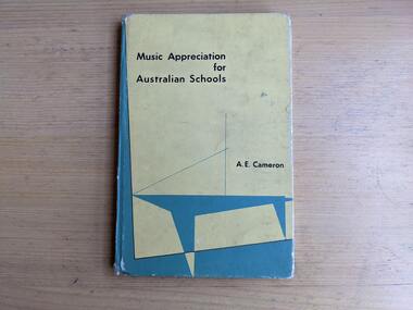
Book, A. E. Cameron, Music Appreciation for Australian Schools, 1958
Hardcover, No Dust Jacket"S. Boyd" inside front cover.walsh st library -
 Robin Boyd Foundation
Book, E W Parker (selected), The Poet's Way: Stage Two, 1954
HardcoverS. Simms. Poetry on leaves. Some annotations in pen throughout.poetry, walsh st library -
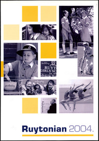 Ruyton Girls' School
Magazine, Ruyton Girls' School, The Ruytonian, 2004
In July 1909, a modest 12-page booklet was put together by members of the fledgling Old Ruytonians Association (ORA) and distributed to the Ruyton Girls' School community. It was one of their first projects, and their aim was to nurture continuing interest in the School among former and current students. They named it "The Ruytonian." At first, The Ruytonian was produced twice yearly, and always bore a plain cover with a simple name banner. Initially, it was the work of volunteer editors from the ORA, but in 1913 they handed the publication over to the first student editors, Esther Gibson and Lucy Tickell. Since that time, the style and content of The Ruytonian has continuously evolved. The biggest shifts occurred in 1942 when it transitioned to a yearly publication, and in 1969 when it moved to a larger A4 format with a cover image specifically selected for that year.The record has strong historic significance as it pertains to the fourth oldest girls' school in Victoria, Australia. Ruyton was founded in 1878 in the Bulleen Road, Kew, home of newly widowed Mrs Charlotte Anderson (now High Street South). Thus, the record can be used as a reference example for research into Victorian school history. The record's significance is further enhanced by its exceptionally well-documented provenance, having remained the property of Ruyton Girls' School since its production.Colour publication printed on white paper. 104 pages.Front Cover: establishing / g / n / i / p / o / l / e / v / e / d / building / extending / RUYT / GIRLS' SC / Est. 1878 / elbourne Roa / enlarging / producing / elevating / g / n / i / s / i / m / i / x / a / m / Ruytonian 2004. /ruyton girls' school, the ruytonian, kew, old ruytonians association, yearbook, school, publication, girls school, junior school, senior school, journal, students, teacher -
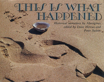 Victorian Aboriginal Corporation for Languages
Book, Luise Hercus, This is what happened : historical narratives by Aborigines, 1986
This book is devoted to the contact history of a hunting and gathering people where they themselves tell the stories in their own languages. Presented as transcriptions of the original stories in Language in facsimile with introductions, gloss and translations by the transcribers. Contains stories by B. Kerwin, R. Moses, H.P. Kulambunt. B. Roberts, M.M. Irinjili D. Harris, J.S. Karntin, C.G. Wurramarrba, Barrengwa, B. Murray, W. Clegg, S. Day, T. Ejai, A. Baranga, I. Joshua, B. Clarmont and C. Omeenyo, H. Goetz, A. Coulthard, J. Boxer; (Lalarin), B.A. Sommer, J. Jack, E. Kennedy, L.J. Kyngayari, V. Lingiari, J.C. Maliwanga and J. Flinders, separately annotated.maps, b&w photographs, word listsyandruwandha, innamicka, nicholson river, djaru, wawarl, western dialect, murinypata, alawa, mission, wangganguru, ngiyambaa, cobar, cape keerweer, wik-ngatharra, macassar, anindilyakwa, dhirari, afghan, chinaman, wagaya, wemba wemba, bilikin brothers, bardi, ngarinjin, massacres, hodgson downs, warndarang, mindiri, wangganguru, old paddy, umpila, native police, gugu-badhun, boninb, atynyamatana, constable mcleay, bowman, oykangand, kukatj, roper creole, paradise, dhirari, fanny brown, wave hill strike, gurindji, vincent lingiari, mainoru station, rembarrnga, land rights, flinders island -
 Uniting Church Archives - Synod of Victoria
Photograph
duboring, c., whewell, j., catford, h., cook, ro, moore, h., heyward, g., quick, w., davies, e., lelean, w. d., hart, richard, bath, h., watsford, j., blamins, w. l., symon, j. c., waugh, j. s., bullas, m., cope, j., annear, d., burridge, w., marsland, j. a., pennell, j., burns, e. b., fison, l., fitchett, w., williams, s., edwards, b., worth, w. s., nicholson, j., allen, j., simpson, j., bickford, j., bogle, a., rigg, a., binks, w., patchell, g., burgess, h. t., james, t., wells, w. p., read, j., newman, c. t., lee, g., edmeades, t., llyod, t. -
 Uniting Church Archives - Synod of Victoria
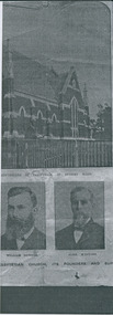
Photograph, Parkville Presbyterian Church, Undated
The College Church congregation initially worshipped in Ormond College in 1891. In 1895 they purchased the site of the present building. A committee set out certain specifications (including the crown tower), and a competition for the best design was won by architect RA Lawson. The building, constructed by Lang Brothers of Parkville at a cost of 2,170 pounds, was opened in 1898. College Church remained the only parish church in Parkville until 1934. The outstanding element is the crown tower, a choice of the first minister, the Reverend Alexander Yule. It is a copy, albeit on a reduced scale, of King's College Chapel, Aberdeen University, of which Reverend Yule was a former student. This crown tower is the only example in Victoria and is possibly unique in Australia. The church is constructed of red brick and Oamaru sandstone with a steeply pitched slate roof and parapeted gables. Windows are in the Gothic pointed arch style. The interior of the Church has a fine timber ceiling with arch braces. There are a number of quality stained glass windows, the two largest being dedicated to Mungo Scott and his wife, Scott having been a benefactor of the Church. The late nineteenth century pipe organ was built by George Fincham and Son (Richmond), with Professor Franklin Peterson as consultant, and was completed in November 1903. In the 1940s College Church was internally re-ordered and this work was designed by prominent church architect, Louis Williams. The church became part of the Uniting Church in Australia in 1977, and ownership subsequently passed to Mar Thoma Syrian Church in 2008. From The Argus, Friday 19 April 1907: Rev. Alexander Yule washeld in highest esteem in his ministerialbrethren and a large circle of friends was abundanrly evident by the expressions ofsorrowful regret at his death and of sympathy with his widow and her three sonsby those who attended the funeral servicesyesterday morning. To most of those present the announcement of Mr. Yule's death, made in "The Argus" on Wednesday, came as a painful surprise. It was known that at the time of his ministerial jubilee last January he shown symptoms of failing health, and that his illness had gradually become more serious, but few among the intimate friends of the family thought the end was so near. Although Mr. Yule suffered much physical weakness, his mental faculties were unimpaired, and he was able to carry on his ministerial work almost to the last. He even conducted the services at the College Church, Parkville, on Sunday, March 31. Testimony is borne that his ministry was appreciated most highly by the important congregations, both in Scotland and Victoria, under his charge; that in the church courts he was a safe and wise counsellor; and that he did excellent service on various committees, and as the convenor of the Theological-hall committee, on which he was appointed by the General Assembly. The esteem in which he was regarded by the Presbyterian Church as a whole was expressed in his election in 1891 to the Moderator's chair of the Victorian Church, and to that of the Federal Assembly in 1901. The funeral service was held at College Church, the scene of Mr. Yule's ministry since 1891. The building was filled to overflowing by a congregation that included most of the members of the metropolitan presbyteries, representatives from several of the provincial presbyterues, the students of the Theological-hall, members of the Parkville congregation, and the children of Miss Sutherland's Home. The pulpit and furniture were draped in black, and the plain oak coffin rested on the communion-table. The simple yet impressive service usual with the Presbyterian Church was conducted by Professor Rentoul, president of the Theological-hall Senatus, who was assisted by Professor Skene, Rev. W. Fraser (moderator of the Melbourne North Presbytery), Rev. D. S. McEacharn, and the Rev. John Thomson, a life-long friend of the departed minister. The Dead March in "Saul" was played on the organ as the coffin was borne to the hearse. The procession along Parkville-crescent to the cemetery gates was a notable one, and in the following order:—Theological-hall students; the hearse; the chief mourners—Dr. Yule, Rev. A. Yule, Mr. James Yule, and Mr. Groom, M.H.R., a relative of the family; the Theological-hall professors and committee; members of the presbyteries; and other friends, making a large and repre-sentative gathering. At the grave Professor Rentoul, Rev. Dr. Meiklejohn, Rev. D. Ross, and the Rev. Dr. Marshall officiated. The pall-bearers were Revs. D. S. McEachran, J. Thomson, A. McDonald, R. J. Smith,Mr. P. McLennan and Mr. L. E. Groom, M.H.R. The funeral arrangement were in the hands of Mr. Josiah Holdsworth.Portion of photocopy of the church and two of the portraits.college church, presbyterian church, yule, rev. alexander -
 Uniting Church Archives - Synod of Victoria
Photograph, Parkville Presbyterian Church, Undated
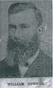
The College Church congregation initially worshipped in Ormond College in 1891. In 1895 they purchased the site of the present building. A committee set out certain specifications (including the crown tower), and a competition for the best design was won by architect RA Lawson. The building, constructed by Lang Brothers of Parkville at a cost of 2,170 pounds, was opened in 1898. College Church remained the only parish church in Parkville until 1934. The outstanding element is the crown tower, a choice of the first minister, the Reverend Alexander Yule. It is a copy, albeit on a reduced scale, of King's College Chapel, Aberdeen University, of which Reverend Yule was a former student. This crown tower is the only example in Victoria and is possibly unique in Australia. The church is constructed of red brick and Oamaru sandstone with a steeply pitched slate roof and parapeted gables. Windows are in the Gothic pointed arch style. The interior of the Church has a fine timber ceiling with arch braces. There are a number of quality stained glass windows, the two largest being dedicated to Mungo Scott and his wife, Scott having been a benefactor of the Church. The late nineteenth century pipe organ was built by George Fincham and Son (Richmond), with Professor Franklin Peterson as consultant, and was completed in November 1903. In the 1940s College Church was internally re-ordered and this work was designed by prominent church architect, Louis Williams. The church became part of the Uniting Church in Australia in 1977, and ownership subsequently passed to Mar Thoma Syrian Church in 2008. From The Argus, Friday 19 April 1907: Rev. Alexander Yule washeld in highest esteem in his ministerialbrethren and a large circle of friends was abundanrly evident by the expressions ofsorrowful regret at his death and of sympathy with his widow and her three sonsby those who attended the funeral servicesyesterday morning. To most of those present the announcement of Mr. Yule's death, made in "The Argus" on Wednesday, came as a painful surprise. It was known that at the time of his ministerial jubilee last January he shown symptoms of failing health, and that his illness had gradually become more serious, but few among the intimate friends of the family thought the end was so near. Although Mr. Yule suffered much physical weakness, his mental faculties were unimpaired, and he was able to carry on his ministerial work almost to the last. He even conducted the services at the College Church, Parkville, on Sunday, March 31. Testimony is borne that his ministry was appreciated most highly by the important congregations, both in Scotland and Victoria, under his charge; that in the church courts he was a safe and wise counsellor; and that he did excellent service on various committees, and as the convenor of the Theological-hall committee, on which he was appointed by the General Assembly. The esteem in which he was regarded by the Presbyterian Church as a whole was expressed in his election in 1891 to the Moderator's chair of the Victorian Church, and to that of the Federal Assembly in 1901. The funeral service was held at College Church, the scene of Mr. Yule's ministry since 1891. The building was filled to overflowing by a congregation that included most of the members of the metropolitan presbyteries, representatives from several of the provincial presbyterues, the students of the Theological-hall, members of the Parkville congregation, and the children of Miss Sutherland's Home. The pulpit and furniture were draped in black, and the plain oak coffin rested on the communion-table. The simple yet impressive service usual with the Presbyterian Church was conducted by Professor Rentoul, president of the Theological-hall Senatus, who was assisted by Professor Skene, Rev. W. Fraser (moderator of the Melbourne North Presbytery), Rev. D. S. McEacharn, and the Rev. John Thomson, a life-long friend of the departed minister. The Dead March in "Saul" was played on the organ as the coffin was borne to the hearse. The procession along Parkville-crescent to the cemetery gates was a notable one, and in the following order:—Theological-hall students; the hearse; the chief mourners—Dr. Yule, Rev. A. Yule, Mr. James Yule, and Mr. Groom, M.H.R., a relative of the family; the Theological-hall professors and committee; members of the presbyteries; and other friends, making a large and repre-sentative gathering. At the grave Professor Rentoul, Rev. Dr. Meiklejohn, Rev. D. Ross, and the Rev. Dr. Marshall officiated. The pall-bearers were Revs. D. S. McEachran, J. Thomson, A. McDonald, R. J. Smith,Mr. P. McLennan and Mr. L. E. Groom, M.H.R. The funeral arrangement were in the hands of Mr. Josiah Holdsworth.William Downes - one of the founders.college church, presbyterian church, yule, rev. alexander -
 Uniting Church Archives - Synod of Victoria
Photograph, Parkville Presbyterian Church, Undated
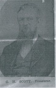
The College Church congregation initially worshipped in Ormond College in 1891. In 1895 they purchased the site of the present building. A committee set out certain specifications (including the crown tower), and a competition for the best design was won by architect RA Lawson. The building, constructed by Lang Brothers of Parkville at a cost of 2,170 pounds, was opened in 1898. College Church remained the only parish church in Parkville until 1934. The outstanding element is the crown tower, a choice of the first minister, the Reverend Alexander Yule. It is a copy, albeit on a reduced scale, of King's College Chapel, Aberdeen University, of which Reverend Yule was a former student. This crown tower is the only example in Victoria and is possibly unique in Australia. The church is constructed of red brick and Oamaru sandstone with a steeply pitched slate roof and parapeted gables. Windows are in the Gothic pointed arch style. The interior of the Church has a fine timber ceiling with arch braces. There are a number of quality stained glass windows, the two largest being dedicated to Mungo Scott and his wife, Scott having been a benefactor of the Church. The late nineteenth century pipe organ was built by George Fincham and Son (Richmond), with Professor Franklin Peterson as consultant, and was completed in November 1903. In the 1940s College Church was internally re-ordered and this work was designed by prominent church architect, Louis Williams. The church became part of the Uniting Church in Australia in 1977, and ownership subsequently passed to Mar Thoma Syrian Church in 2008. From The Argus, Friday 19 April 1907: Rev. Alexander Yule washeld in highest esteem in his ministerialbrethren and a large circle of friends was abundanrly evident by the expressions ofsorrowful regret at his death and of sympathy with his widow and her three sonsby those who attended the funeral servicesyesterday morning. To most of those present the announcement of Mr. Yule's death, made in "The Argus" on Wednesday, came as a painful surprise. It was known that at the time of his ministerial jubilee last January he shown symptoms of failing health, and that his illness had gradually become more serious, but few among the intimate friends of the family thought the end was so near. Although Mr. Yule suffered much physical weakness, his mental faculties were unimpaired, and he was able to carry on his ministerial work almost to the last. He even conducted the services at the College Church, Parkville, on Sunday, March 31. Testimony is borne that his ministry was appreciated most highly by the important congregations, both in Scotland and Victoria, under his charge; that in the church courts he was a safe and wise counsellor; and that he did excellent service on various committees, and as the convenor of the Theological-hall committee, on which he was appointed by the General Assembly. The esteem in which he was regarded by the Presbyterian Church as a whole was expressed in his election in 1891 to the Moderator's chair of the Victorian Church, and to that of the Federal Assembly in 1901. The funeral service was held at College Church, the scene of Mr. Yule's ministry since 1891. The building was filled to overflowing by a congregation that included most of the members of the metropolitan presbyteries, representatives from several of the provincial presbyterues, the students of the Theological-hall, members of the Parkville congregation, and the children of Miss Sutherland's Home. The pulpit and furniture were draped in black, and the plain oak coffin rested on the communion-table. The simple yet impressive service usual with the Presbyterian Church was conducted by Professor Rentoul, president of the Theological-hall Senatus, who was assisted by Professor Skene, Rev. W. Fraser (moderator of the Melbourne North Presbytery), Rev. D. S. McEacharn, and the Rev. John Thomson, a life-long friend of the departed minister. The Dead March in "Saul" was played on the organ as the coffin was borne to the hearse. The procession along Parkville-crescent to the cemetery gates was a notable one, and in the following order:—Theological-hall students; the hearse; the chief mourners—Dr. Yule, Rev. A. Yule, Mr. James Yule, and Mr. Groom, M.H.R., a relative of the family; the Theological-hall professors and committee; members of the presbyteries; and other friends, making a large and repre-sentative gathering. At the grave Professor Rentoul, Rev. Dr. Meiklejohn, Rev. D. Ross, and the Rev. Dr. Marshall officiated. The pall-bearers were Revs. D. S. McEachran, J. Thomson, A. McDonald, R. J. Smith,Mr. P. McLennan and Mr. L. E. Groom, M.H.R. The funeral arrangement were in the hands of Mr. Josiah Holdsworth.G. H. Scott - Treasurer.college church, presbyterian church, yule, rev. alexander -
 Uniting Church Archives - Synod of Victoria
Photograph, Parkville Presbyterian Church, Undated
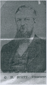
The College Church congregation initially worshipped in Ormond College in 1891. In 1895 they purchased the site of the present building. A committee set out certain specifications (including the crown tower), and a competition for the best design was won by architect RA Lawson. The building, constructed by Lang Brothers of Parkville at a cost of 2,170 pounds, was opened in 1898. College Church remained the only parish church in Parkville until 1934. The outstanding element is the crown tower, a choice of the first minister, the Reverend Alexander Yule. It is a copy, albeit on a reduced scale, of King's College Chapel, Aberdeen University, of which Reverend Yule was a former student. This crown tower is the only example in Victoria and is possibly unique in Australia. The church is constructed of red brick and Oamaru sandstone with a steeply pitched slate roof and parapeted gables. Windows are in the Gothic pointed arch style. The interior of the Church has a fine timber ceiling with arch braces. There are a number of quality stained glass windows, the two largest being dedicated to Mungo Scott and his wife, Scott having been a benefactor of the Church. The late nineteenth century pipe organ was built by George Fincham and Son (Richmond), with Professor Franklin Peterson as consultant, and was completed in November 1903. In the 1940s College Church was internally re-ordered and this work was designed by prominent church architect, Louis Williams. The church became part of the Uniting Church in Australia in 1977, and ownership subsequently passed to Mar Thoma Syrian Church in 2008. From The Argus, Friday 19 April 1907: Rev. Alexander Yule washeld in highest esteem in his ministerialbrethren and a large circle of friends was abundanrly evident by the expressions ofsorrowful regret at his death and of sympathy with his widow and her three sonsby those who attended the funeral servicesyesterday morning. To most of those present the announcement of Mr. Yule's death, made in "The Argus" on Wednesday, came as a painful surprise. It was known that at the time of his ministerial jubilee last January he shown symptoms of failing health, and that his illness had gradually become more serious, but few among the intimate friends of the family thought the end was so near. Although Mr. Yule suffered much physical weakness, his mental faculties were unimpaired, and he was able to carry on his ministerial work almost to the last. He even conducted the services at the College Church, Parkville, on Sunday, March 31. Testimony is borne that his ministry was appreciated most highly by the important congregations, both in Scotland and Victoria, under his charge; that in the church courts he was a safe and wise counsellor; and that he did excellent service on various committees, and as the convenor of the Theological-hall committee, on which he was appointed by the General Assembly. The esteem in which he was regarded by the Presbyterian Church as a whole was expressed in his election in 1891 to the Moderator's chair of the Victorian Church, and to that of the Federal Assembly in 1901. The funeral service was held at College Church, the scene of Mr. Yule's ministry since 1891. The building was filled to overflowing by a congregation that included most of the members of the metropolitan presbyteries, representatives from several of the provincial presbyterues, the students of the Theological-hall, members of the Parkville congregation, and the children of Miss Sutherland's Home. The pulpit and furniture were draped in black, and the plain oak coffin rested on the communion-table. The simple yet impressive service usual with the Presbyterian Church was conducted by Professor Rentoul, president of the Theological-hall Senatus, who was assisted by Professor Skene, Rev. W. Fraser (moderator of the Melbourne North Presbytery), Rev. D. S. McEacharn, and the Rev. John Thomson, a life-long friend of the departed minister. The Dead March in "Saul" was played on the organ as the coffin was borne to the hearse. The procession along Parkville-crescent to the cemetery gates was a notable one, and in the following order:—Theological-hall students; the hearse; the chief mourners—Dr. Yule, Rev. A. Yule, Mr. James Yule, and Mr. Groom, M.H.R., a relative of the family; the Theological-hall professors and committee; members of the presbyteries; and other friends, making a large and repre-sentative gathering. At the grave Professor Rentoul, Rev. Dr. Meiklejohn, Rev. D. Ross, and the Rev. Dr. Marshall officiated. The pall-bearers were Revs. D. S. McEachran, J. Thomson, A. McDonald, R. J. Smith,Mr. P. McLennan and Mr. L. E. Groom, M.H.R. The funeral arrangement were in the hands of Mr. Josiah Holdsworth.G. H. Scott - Treasurer.college church, presbyterian church, yule, rev. alexander -
 Uniting Church Archives - Synod of Victoria
Photograph, Parkville Presbyterian Church, Undated
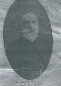
The College Church congregation initially worshipped in Ormond College in 1891. In 1895 they purchased the site of the present building. A committee set out certain specifications (including the crown tower), and a competition for the best design was won by architect RA Lawson. The building, constructed by Lang Brothers of Parkville at a cost of 2,170 pounds, was opened in 1898. College Church remained the only parish church in Parkville until 1934. The outstanding element is the crown tower, a choice of the first minister, the Reverend Alexander Yule. It is a copy, albeit on a reduced scale, of King's College Chapel, Aberdeen University, of which Reverend Yule was a former student. This crown tower is the only example in Victoria and is possibly unique in Australia. The church is constructed of red brick and Oamaru sandstone with a steeply pitched slate roof and parapeted gables. Windows are in the Gothic pointed arch style. The interior of the Church has a fine timber ceiling with arch braces. There are a number of quality stained glass windows, the two largest being dedicated to Mungo Scott and his wife, Scott having been a benefactor of the Church. The late nineteenth century pipe organ was built by George Fincham and Son (Richmond), with Professor Franklin Peterson as consultant, and was completed in November 1903. In the 1940s College Church was internally re-ordered and this work was designed by prominent church architect, Louis Williams. The church became part of the Uniting Church in Australia in 1977, and ownership subsequently passed to Mar Thoma Syrian Church in 2008. From The Argus, Friday 19 April 1907: Rev. Alexander Yule washeld in highest esteem in his ministerialbrethren and a large circle of friends was abundanrly evident by the expressions ofsorrowful regret at his death and of sympathy with his widow and her three sonsby those who attended the funeral servicesyesterday morning. To most of those present the announcement of Mr. Yule's death, made in "The Argus" on Wednesday, came as a painful surprise. It was known that at the time of his ministerial jubilee last January he shown symptoms of failing health, and that his illness had gradually become more serious, but few among the intimate friends of the family thought the end was so near. Although Mr. Yule suffered much physical weakness, his mental faculties were unimpaired, and he was able to carry on his ministerial work almost to the last. He even conducted the services at the College Church, Parkville, on Sunday, March 31. Testimony is borne that his ministry was appreciated most highly by the important congregations, both in Scotland and Victoria, under his charge; that in the church courts he was a safe and wise counsellor; and that he did excellent service on various committees, and as the convenor of the Theological-hall committee, on which he was appointed by the General Assembly. The esteem in which he was regarded by the Presbyterian Church as a whole was expressed in his election in 1891 to the Moderator's chair of the Victorian Church, and to that of the Federal Assembly in 1901. The funeral service was held at College Church, the scene of Mr. Yule's ministry since 1891. The building was filled to overflowing by a congregation that included most of the members of the metropolitan presbyteries, representatives from several of the provincial presbyterues, the students of the Theological-hall, members of the Parkville congregation, and the children of Miss Sutherland's Home. The pulpit and furniture were draped in black, and the plain oak coffin rested on the communion-table. The simple yet impressive service usual with the Presbyterian Church was conducted by Professor Rentoul, president of the Theological-hall Senatus, who was assisted by Professor Skene, Rev. W. Fraser (moderator of the Melbourne North Presbytery), Rev. D. S. McEacharn, and the Rev. John Thomson, a life-long friend of the departed minister. The Dead March in "Saul" was played on the organ as the coffin was borne to the hearse. The procession along Parkville-crescent to the cemetery gates was a notable one, and in the following order:—Theological-hall students; the hearse; the chief mourners—Dr. Yule, Rev. A. Yule, Mr. James Yule, and Mr. Groom, M.H.R., a relative of the family; the Theological-hall professors and committee; members of the presbyteries; and other friends, making a large and repre-sentative gathering. At the grave Professor Rentoul, Rev. Dr. Meiklejohn, Rev. D. Ross, and the Rev. Dr. Marshall officiated. The pall-bearers were Revs. D. S. McEachran, J. Thomson, A. McDonald, R. J. Smith,Mr. P. McLennan and Mr. L. E. Groom, M.H.R. The funeral arrangement were in the hands of Mr. Josiah Holdsworth.Rev. Alexander Yule M.A.Born 1830 - 1907.college church, presbyterian church, yule, rev. alexander -
 Uniting Church Archives - Synod of Victoria
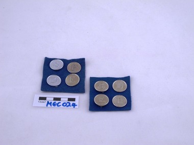
Merit Badges, Methodist Girls Comradeship
... silver metal merit badges on a square of blue felt. S - Service.... S - Service, D - Devotional, E - Educational, P - Physical ...MGC024.1 - MGC024.2 Methodist Girls Comradeship round silver metal merit badges on a square of blue felt. S - Service, D - Devotional, E - Educational, P - Physical. -
 Uniting Church Archives - Synod of Victoria
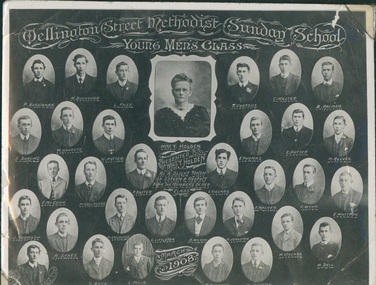
Photograph, 1908
Mrs Mary Holden (1843 - 1930) was the mother of the Rev Albert Thomas Holden CBE V.D., B.A., D.D. Director of the Methodist Inland Missions, Chaplain-General of the A.I.F. and President-General of the Methodist Conference of Australasia. She was the mother-in-law of the Rev. Samuel HobanB & W composite photo of the Young Men's Class at Ashby Methodist Sunday School in Wellington Street, comprising 30 oval head and shoulders photos of the young men, and 1 rectangular head and shoulders photo of their teacher, Mrs T. Holden."Wellington Street Methodist Sunday School Young Men's Class. Presented to Mrs T. Holden as a slight token of esteem and respect from the members of her class. March 1908. P. Buchanan,N. Buchanan, L. Pash, T. Cortous, C. Walter, B. Palmer, S. Dorling, W. Hancock, N. Potter, E. Thomas, E. Potter, H. Reeves, R. McCann, H. Gallagher, P. Baxter, L. Viccars, F. Walker, F. Wynn, E. Whitton, J. Thomson, A. Sykes, W. Gallagher, G. Littleton, A. Wilson, N. Johnston, H. Viccars, H. Bell, C. Cortous, C. Bond, L. Muir, R. Thomson, H. Johnston.mary holden, rev albert thomas holden, rev samuel hoban, ashby methodist, sunday school