Showing 1265 items
matching neil
-
 Bendigo Historical Society Inc.
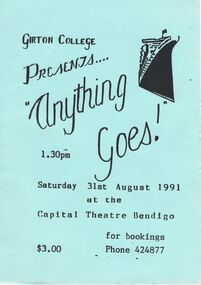
Document - GIRTON COLLEGE PRESENTING ANYTHING GOES, CAPITAL THEATRE BENDIGO, 27 August, 1991
Girton College Presenting Anything Goes, Capital Theatre Bendigo. a/ Flyer: 1.30pm Saturday 31st August 1991. $3.00 Bookings 42 4877. b/ Girton College Presents ''Anything Goes!'' 27th, 28th August, Capital Theatre, Bendigo. The Plot. Cast: John Elder, Genevieve Gilbert, Scott Williams, Amber McDonald, Brendon Marshall, Kaye Porter, Lok Thornton, Anna Ledwich, Jason Burns, Simon Evans, Sarah Tweed, Amelia Doble, Jane Phillips, Linden Whiting, David Pearse, Jenni Rosen, Nick Evans. Girls: Louisa Dalley, Caroline Davey, Allisa Gullan, Adam Middlemis, Alistair Hampton, Jarrod Harris, Adrian Currie, Mark Tierney, Ben Brown, James Brook, Georgia Laughton, Carolyn Macdonald, Lachlan King, Luke Tracey, Sally Branson, Michael Elphinstone, Natalie Lawson, Tanya Kairn, Matthew Evans, Sally Thorn, Emma Chuck, Natalie Davey, Geraldine Carney, Henry Chan, Rossetti Luk, Kelly Chuck, Corinne McAlpine, Tania Ray, Sally Morris, Rachel Roberts. Dancers: Rachel Campbell, Alisa Gullan, Kate Harris, Carolyn Macdonald, Rachel Millar, Jane Phillips, Carlie Sutton, Linden Whiting, Lisa Owen, Kim Davis. Sound: Bronwyn Letts, Anthea Moncrieff. Technical Lighting Spot: Davydd Griffiths, Matthew Whiting. Backstage: Emma Goulding, Dallas Anson, Sarah Carlile, Alix Osborn, Matthew Williams, Michael Porter, Kasie Watson, Alexandra Hocking, Nerida Clark, Lisa Bibby, Sher Anson, Emma Toon, Mandi Smith. Production Mrs R Pedersen, Mr R Cooke, Matthew Tilling, Michael Chittick, Mrs K Branson, Mrs A Leech with year 9 Design Students. Mr L Young, Mrs R Pederson, Mrs J Whiting, Brenda Macdonald, Pam Sutton, Mrs S Draffin, Kara Draffin, Miss M Somerville, Mr S Jackson, Mrs S Neale, Adelle Middlemis, Moira Christie, Wendy McKinlay, Shona Christie, Mrs V Jackman. Orchestra: Mr R Cooke, Maria Ciancio, Grant Welling, Susannah Breaden, Meredith Cox, Kylie Smith, Jane Davies, Jeremy Breaden, Mal Hausler, Norm Gray, Kevin Kieley, Neil Bassett, Kevin Simmonds, Betty Higgs, John Snowdon, Peter Stewart. We gratefully acknowledge the assistance of: Keith Macdonald, Macdonald's Spring Gully Nursery. Graham & Irene Keogh, Limerick Tavern. Ashman's Formal Hire. Program produced by Ms S Albion. Program designed by Jason Williams, Lok Thornton and Matt Robinson. Graphics by Broughton Snell and Amber McDonald. C & d/Tickets no.s K8 & K9, Girton College Presents Anything Goes! 7.30pm, Wednesday 28th August 1991 at the Capital Theatre Bendigo Adult $6 Conc. $3.entertainment, theatre, anything goes, girton college presenting anything goes, capital theatre bendigo. a/ flyer: 1.30pm 31st august 1991. $3.00 bookings 42 4877. b/ girton college presents ''anything goes!'' 27th, 28th 1991, capital theatre, bendigo. the plot. cast: john elder, genevieve gilbert, scott williams, amber mcdonald, brendon marshall, kaye porter, lok thornton, anna ledwich, jason burns, simon evans, sarah tweed, amelia doble, jane phillips, linden whiting, david pearse, jenni rosen, nick evans. girls: louisa dalley, caroline davey, allisa gullan, adam middlemis, alistair hampton, jarrod harris, adrian currie, mark tierney, ben brown, james brook, georgia laughton, carolyn macdonald, lachlan king, luke tracey, sally branson, michael elphinstone, natalie lawson, tanya kairn, matthew evans, sally thorn, emma chuck, natalie davey, geraldine carney, henry chan, rossetti luk, kelly chuck, corinne mcalpine, tania ray, sally morris, rachel roberts. dancers: rachel campbell, alisa gullan, kate harris, carolyn macdonald, rachel millar, jane phillips, carlie sutton, linden whiting, lisa owen, kim davis. sound: bronwyn letts, anthea moncrieff. technical lighting spot: davydd griffiths, matthew whiting. backstage: emma goulding, dallas anson, sarah carlile, alix osborn, matthew williams, michael porter, kasie watson, alexandra hocking, nerida clark, lisa bibby, sher anson, emma toon, mandi smith. production mrs r pedersen, mr r cooke, matthew tilling, michael chittick, mrs k branson, mrs a leech with year 9 design students. mr l young, mrs r pederson, mrs j whiting, brenda macdonald, pam sutton, mrs s draffin, kara draffin, miss m somerville, mr s jackson, mrs s neale, adelle middlemis, moira christie, wendy mckinlay, shona christie, mrs v jackman. orchestra: mr r cooke, maria ciancio, grant welling, susannah breaden, meredith cox, kylie smith, jane davies, jeremy breaden, mal hausler, norm gray, kevin kieley, neil bassett, kevin simmonds, betty higgs, john snowdon, peter stewart. we gratefully acknowledge the assistance of: keith macdonald, macdonald's spring gully nursery. graham & irene keogh, limerick tavern. ashman's formal hire. program produced by ms s albion. program by jason williams, lok thornton and matt robinson. graphics by broughton snell and amber mcdonald. c & d/tickets no.s k8 & k9, 7.30pm, 28th august 1991 adult $6 conc. $3. -
 Bendigo Military Museum
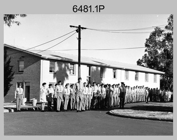
Photograph - Commanding Officer’s Parade at the Army Survey Regiment, Fortuna Villa, Bendigo, c1977
This is a set of 11 photographs of a Commanding Officer’s (CO’s) Parade held at the Army Survey Regiment, Bendigo in circa 1977. Key appointments at the time were LTCOL Bob Skitch, the Commanding Officer from 1976 to 1980 and WO1 Aub Harvey, the RSM of the unit from 1976 to 1982. The dates on the cover sheet are incorrect as female personnel appear in the summer uniform that was superseded in early 1979.This is a set of 11 photographs of a Commanding Officer’s (CO’s) Parade held at the Army Survey Regiment, Bendigo in circa 1977. The photographs were printed on photographic paper and are part of the Army Survey Regiment’s Collection. The black and white photographs were scanned at 300 dpi. .1) - Photo, Black & white, c1977. Air Survey Squadron L to R: WO1 Bob Mason, PTE CPL Marrianne (Van De Zee) De Groot, PTE Julia (Spark) Fitts, CPL Greg Gilbert, unidentified (x2), SGT Bruce Gordon, remainder unidentified. WO1 Graeme Birrell on far right. .2) & .3) - Photo, Black & white, c1977. Air Survey Squadron L to R: SPR Bob Clisby, CPL Alan Staley, unidentified, CPL John Smith, unidentified, CPL Phil McGuire, CPL Peter Mustart, SPR Gary Ames, WO1 Bob Mason – in foreground, unidentified, PTE Julia (Spark) Fitts, unidentified (x2), PTE CPL Marrianne (Van De Zee) De Groot, unidentified (x2), CPL Greg Gilbert, SGT Bruce Gordon. .4) - Photo, Black & white, c1977. Headquarter Squadron L to R: WO2 Max Neil, WO1 Alex Cairney, unidentified, SSGT Pat Lumsden, unidentified (x2), CPL Eddie Jacobs, unidentified (x3), SSGT Alan Strain, CPL Jim Cook. .5) - Photo, Black & white, c1977. Lithographic Squadron L to R: WO1 Tibby Szentirmay BEM, SSGT Jeff Lynch, unidentified, WO1 Fred Panknin, unidentified, SPR Mick ‘Buddha’ Ellis, unidentified, CPL Warren ‘Waldo’ Shirley, CPL John ‘Flash’ Anderson, SGT Trevor Osborne, unidentified, SPR Keith Quinton, unidentified, CPL Bill Jones, unidentified, PTE Janet (Chopping) Justin, WO2 Tom Pattison, SGT Gavin Neilson, SGT Graeme Jeffers, SGT Jeff Willey, SGT Greg Francis-Wright. .6) - Photo, Black & white, c1977. Cartographic Squadron – unidentified personnel. .7) - Photo, Black & white, c1977. Lithographic Squadron – unidentified personnel. .8) - Photo, Black & white, c1977. L to R: WO2 Tom Pattison, RSM WO1 Aub Harvey – facing camera, unidentified (x3), CO LTCOL Bob Skitch facing away receiving salute, remainder unidentified. .9) - Photo, Black & white, c1977. L to R: CAPT Graham Baker, unidentified, CO LTCOL Bob Skitch facing away, unidentified (x3), RSM WO1 Aub Harvey taking notes, unidentified. .10) - Photo, Black & white, c1977. Cartographic Squadron L to R: CO LTCOL Bob Skitch facing away receiving salute, unidentified, MAJ Robin Wilson, unidentified, RSM WO1 Aub Harvey, unidentified. .11) - Photo, Black & white, c1977. Lithographic Squadron undergoing inspection. WO1 Marj Knight at far left..1P to .11P – There are no personnel identified. “Parade 1979 or 1980” annotated on the cover sheet. Note – Dates are probably incorrect.royal australian survey corps, rasvy, army survey regiment, army svy regt, fortuna -
 Flagstaff Hill Maritime Museum and Village
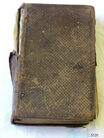
Book - Religious Book, The Holy Bible, 1836
This Holy Bible is entitled "The Holy Bible containing the Old and New Testaments, translated out of the original tongues: and with former translations diligently compared and revised by His Majesty's Spiritual Command." It was printed by Sir D. Hunter Blair and M.T. Bruce in Edinburgh, 1836, printers to the King's most Excellent Majesty, H.B.S." The Bible belonged to David and Alice Ellis, a young couple married in Dublin in 1855. It has been handed down in the Ellis family until it was donated, together with other personal effects, in 2004 by David and Alice’s granddaughter, daughter of David Ellis Junior. Alice treated the Bible as an important posession. On 6th October 1855 newlyweds David and Alice Ellis set sail for Australia in the brand new Schomberg, considered the most perfect clipper ship. She was built as an emigrant ship in Aberdeen and set sail from Liverpool on her maiden voyage, bound for Melbourne, Australia. She was loaded with 430 passengers plus cargo that included iron rails and equipment intended for building the Geelong Railway and a bridge over the Yarra from Melbourne to Hawthorn. On 27th December 1855, only one day from her Melbourne destination, the Schomberg was grounded on a sand-spit on the Victorian coast near Peterborough. The passengers and crew were all safely rescued by a passing small steamer, the SS Queen, which traded between Melbourne and Warrnambool, and taken to Melbourne. The passengers had been told, when leaving the sinking Schomberg, that all they could take with them was a small basket or handbag. A newspaper article later mentioned that one of the things Alice made space for in her basket was her Bible. (It is unclear whether Alice took any possessions with her onto the SS Queen, but a note accompanying the donation of the Bible and basket states that the items were “left on deck and salvaged as Schomberg went down”.) Another steamer was despatched from Melbourne to retrieve the passengers’ luggage from the Schomberg and Alice was reunited with all of her boxes of belongings. Other steamers helped unload the cargo until the change in weather made it too difficult. Although the Schomberg was wrecked there were no lives lost. At that time David was 23 years old (born in Wales, 1832) and his new bride Alice was 26 (born in Dublin, 1829). They had been given letters of introduction to people in Tasmania so they travelled there from Melbourne. However the couple only stayed on that island for about a year before they returned to the Western District of Victoria. David worked for Mr Neil Black as a gardener for a while then, when the land in the area was made available by the Victorian government, David and Alice claimed a selection of land on Noorat Road in the Terang district. They settled there for the remainder of their lives, expanding their property “Allambah” as opportunities arose. A document accompanying the donation lists the names of six children; William, Grace (c. 1859-1946), Thomas (c. 1866 – 1939), David (c. 1962 – 1953), James and Victor. David died on 13th April 1911, aged 79, at their property. Alice passed away the following year, November 1912, aged 83. Alice’s obituary described her as “a very homely, kindly-natured woman, who was highly esteemed by a large circle of friends; and she was also a firm adherent of the Presbyterian Church”. At the time of Alice’s death she left behind three sons and one daughter. Her daughter Grace Ellis was also a very active member of the Terang Presbyterian Church and a member of the PWMU (Presbyterian Women’s Missionary Union). She was also involved in the Red Cross and other charities. Grace passed away in 1946, aged 87. David and Alice Ellis were amongst the very earlies pioneers of the Terang district of Western Victoria. Their donated possessions are a sample of the personal effects of emigrants to Australia. The donated items are a sample of the personal goods carried aboard a significant migrant ship in 1855. They are also significant for their association with the Schomberg. The Schomberg, which is on the Victorian Heritage Register (VHR S612), has great historical significance as a rare example of a large, fast clipper ship on the England to Australia run, carrying emigrants at the time of the Victorian gold rush. She represents the technical advances made to break sailing records between Europe and Australia. Flagstaff Hill’s collection of artefacts from the Schomberg is significant for its association with the shipwreck, The collection is primarily significant because of the relationship between the objects, as together they have a high potential to interpret the story of the Schomberg. It is archaeologically significant as the remains of an international passenger Ship. It is historically significant for representing aspects of Victoria’s shipping history and for its association with the shipwreck and the ship, which was designed to be fastest and most luxurious of its day Bible, known as the Ellis - Schomberg Bible, with patterned brown leather cover. Printed by Sir D. Hunter Blair and M.T. Bruce, Edinburgh 1836. Bookmark of card placed within Bible’s pages is from Keswick Book Depot, Melbourne. Bible has hand written inscriptions inside front and back covers and has been well used. Bible was amongst the possessions of David and Alice Ellis, passengers on the Schomberg when wrecked in 1855.Scripture references and notes are hand written in pencil on front and back inner pages. Bookmark card has printed inscription; on front “BOOK MARK / KESWICK / BOOK / DEPOT / EVERYTHING / EVANGELISTIC / 315 COLLINS ST / MELBOURNE / CENT. 3013”, on back is line drawing of a stem of iris flowers above the verse “The entrance of Thy / words giveth light; it / giveth understanding / unto the Simple. Ps. 119-30” flagstaff hill, warrnambool, shipwrecked coast, flagstaff hill maritime museum, maritime museum, shipwreck coast, flagstaff hill maritime village, great ocean road, schomberg, holy bible, schomberg bible, d hunter blair and m t bruce, 1836 bible, 1855 shipwreck, peterborough shipwreck, ss queen, david ellis, alice ellis, allambah terang, dublin emigrants, terang presbyterian church, western district victoria -
 Federation University Historical Collection
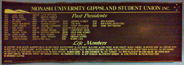
Photograph - Photograph - Colour, Monash University Gippsland Students Union Past Presidents Board, 2014
The Monash University Gippsland Students Union (MUGSU) closed its doors in 2016.Timber honour board with gold painted names. Past Presidents 1972 John Vines 1973 Peter Vines 1974 Cal Callister 1975 Ed Brew 1976 Phillip McRoberts 1977 Chris Hobson 1978 Ken jeanes 1979 Greg Vines 1980 Michael Flynn 1981-2 Chris Allen 1983 Roslyn Heuer 1984 John Dougan 1985-6 Clive Pattison 1987 Martin Gamble 1988 Timothy Feely 1989 Peter Shacklock 1990 Sharon Cooke 1991 Jerome Foenander 1992-3 Josh Beggs 1994 Graeme Wiggins 1995-6 Heather Anderson 1997 Ross Goeman 1998-9 Jenny Farrar 2000-1 Ken Hull 2002 Andrew Schmidt 2003 Tim Burl 2004 Terry Pritchard 2005-6 Sean McLoughlan 2007 Christopher Milne 2008 Leslie Anne Schmidt 2009 Julia Aucello 2010 Maghan Hopper 2011 Rowan Lace 2012 Ben Rogers 2013 Ben Rogers / Jason O'Dea 2014 Daniel Whittingham Life Members John Vines, Val Callister, Winifred Miller, Chris Hobson, Peter Herbert, Julie Patrick, Ed Brew, Chris Fraser, Neil Hanley, Max Campbell, Anthony Benn, Christine Body, Abdel Halabi, Murray Homes, Tony Manning, Keith Hamilton, Beatrice Faust, Graham Middlemiss, Jenny Hill, Christian Zahra, Jenny Farrar, Ken Hull, Faye G., Chris Allen, John Harris, Glenn Doolan, Simon Parsons, Brian Grimes, John Hutchinson, Judy Tennant, Brian MacKenzie, Chris Milne, Aspen Kilby, Sarah Lawless, Michael Taplin, Kingsley Pursch, Samantha Fryer, Jeff Gordon, Dorothy Herbert, John Preston, Oscar Ri Hao Tengstudent union, churchill, gippsland, john vines, val callister, winifred miller, chris hobson, peter herbert, julie patrick, ed brew, chris fraser, neil hanley, max campbell, anthony benn, christine body, abdel halabi, murray homes, tony manning, keith hamilton, beatrice faust, graham middlemiss, jenny hill, christian zahra, jenny farrar, ken hull, faye g., chris allen, john harris, glenn doolan, simon parsons, brian grimes, john hutchinson, judy tennant, brian mackenzie, chris milne, aspen kilby, sarah lawless, michael taplin, kingsley pursch, samantha fryer, jeff gordon, dorothy herbert, john preston, oscar ri hao teng, peter vines, cal callister, phillip mcroberts, ken jeanes, greg vines, michael flynn, roslyn heuer, john dougan, clive pattison, martin gamble, timothy feely, peter shacklock, sharon cooke, jerome foenander, josh beggs, graeme wiggins, heather anderson, ross goeman, andrew schmidt, tim burl, terry pritchard, sean mcloughlan, christopher milne, leslie anne schmidt, julia aucello, maghan hopper, rowan lace, ben rogers, ben rogers / jason o'dea, daniel whittingham, gippsland campus, gippsland campus collection -
 Bendigo Military Museum
Photograph - 4th Field Survey Squadron – Operation MIZMAZE 92, Kimberley region, Western Australia, 1992
This is a set of 40 photographs taken in 1992 during 4th Field Survey Squadron’s deployment on Operation MIZMAZE 92 in the Kimberley region of Western Australia from the 13th of May to the 14th of July 1992. The area of operations was Wyndham, Halls Creek and Sandfire Flat. It was a two-part operation involving the field completion of topographic maps and the acquisition of mapping control by GPS field parties utilising Texas Instruments TI4100 Global Positioning System receivers. Survey parties conducted field checking of topographic maps and GPS control acquisition in Perentie 110 Series Survey variant FFR Land Rovers. Three Bell Kiowa LOH helicopters provided by 162 Recce Sqn supported field checking and limited deployment of GPS surveys parties. C-l30 Hercules from 36 Sqn supported deployment and extraction of personnel and equipment to and from from the AO. A Cessna 404 Titan Ambassador from Vee-H Aviation was used as the Wild RC10 camera platform for aerial photography acquisition.This is a set of 40 photographs taken in 1992 during 4th Field Survey Squadron’s deployment on Operation MIZMAZE 92 in the Kimberley region of Western Australia. The colour photographs are on 35mm negative film and are part of the Army Survey Regiment’s Collection. The photographs were scanned at 96 dpi. .1) - Photo, colour, 1992. CAPT Craig Hersant. .2) - Photo, colour, 1992. Unidentified officer/soldier. .3) & .4) - Photo, colour, 1992. Aboriginal rock art - Wandjina Gunduran, Donkey Creek. .5) - Photo, colour, 1992. Aboriginal rock art - Track Wandjinas, Donkey Creek. .6) & .7) - Photo, colour, 1992. CAPT Craig Hersant. .8) - Photo, colour, 1992. Kimberley region topography. CPL Glen Weatherell. .9) - Photo, colour, 1992. Unidentified personnel .10) - Photo, colour, 1992. Supermarket at unknown location. .11) to .13) - Photo, colour, 1992. Caravan park at unknown location. .14) - Photo, colour, 1992. Old bridge at Fitzroy Crosssing. .15) & .16) - Photo, colour, 1992. Survey party in Perentie 110 Series Land Rover. .17) & .18) - Photo, colour, 1992. Kimberley region topography. .19) - Photo, colour, 1992. Kimberley region topography. CPL Glen Weatherell. .20) - Photo, colour, 1992. Kimberley region topography, possibly the Bungle Bungles. .21) - Photo, colour, 1992. Kimberley region topography. SGT Frank Downie. .22) - Photo, colour, 1992. Kimberley region topography: the Bungle Bungles. .23) - Photo, colour, 1992. Kimberley region topography: the Bungle Bungles. .24) - Photo, colour, 1992. Kimberley region topography: the Bungle Bungles. SPR Neil Pedler. .25) & .26) - Photo, colour, 1992. Kimberley region topography: the Bungle Bungles. .27) - Photo, colour, 1992. Kimberley region topography. .28) - Photo, colour, 1992. Survey party with Perentie 110 Series Land Rover. .29) - Photo, colour, 1992. Kimberley region topography. .30) - Photo, colour, 1992. Survey party outside Perentie 110 Series Land Rover. .31) & .32) - Photo, colour, 1992. Survey party operating TI4100 GPS Receiver next to Perentie 110 Series Land Rover. SGT Eddie Jacobs. .33) & .34) - Photo, colour, 1992. Survey party operating TI4100 GPS Receiver next to Perentie 110 Series Land Rover. Unidentified surveyor. .35) - Photo, colour, 1992. Kimberley region topography. Hand water pump at well. .36) - Photo, colour, 1992. Survey party in Perentie 110 Series Land Rover. .37) - Photo, colour, 1992. Kimberley region topography. CPL Glen Weatherell. .38) - Photo, colour, 1992. Kimberley region topography viewed from Bell Kiowa LOH helicopter. .39) & .40) - Photo, colour, 1992. Unidentified surveyor field checking a preliminary map in a Bell Kiowa LOH helicopter..1P to .40P – There are no personnel identified. ‘1992 OP MIZMAZE annotated on negative sleeve.royal australian survey corps, rasvy, 4 fd svy sqn, op mizmaze 92 -
 Federation University Historical Collection
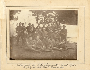
Photograph - Photograph - Sepia, Ballarat School of Mines Cadets, 1916, c1916
Field Marshal Viscount Kitchener of Great Britain was invited by Prime Minister Deakin in 1909 to visit Australia and advise on the best way to provide Australia with a land defence. Kitchener’s report echoed the bill, introduced to Parliament in 1909 and supported by the Opposition Labor Party at its 1908 conference, to introduce compulsory military training in peace time (referred to as universal training). On 1 January 1911, the Commonwealth Defence Act 1911 (Cth) was passed as law and all males aged 12 to 26 were required to receive military training. Men were divided according to age, with junior cadets comprising boys 12-14 years of age, senior cadets comprising boys 14-18, and young men aged 18-26 assigned to the home militia defence. The support of schools was vital to the success of the scheme, since the system of cadet training began in the primary schools, with physical training prescribed by military authorities. Junior cadet training was entirely in the hands of school teachers, who had first been trained by military officers. This early training was less military in nature than focused on physical drill and sport. It also acted to inculcate boys with the notions of loyalty to country and empire. At this age, uniforms were not worn, although there were schools with pre-existing uniformed cadet units, who continued to do so. Senior Cadets were organised by Training Areas, administered by Area Officers. If a school had at least 60 senior cadets, they could form their own units. Unlike their junior counterparts, Senior Cadets were issued uniforms, a rifle, and learned the foundations necessary for service in any arm of the defence forces. Boys and men could be exempted from compulsory training if they lived more than five miles from the nearest training site, or were passed medically unfit. Those who failed to register for training were punished with fines or jail sentences, and the severity of this punishment generated some of the strongest opposition to the scheme. While institutions such as the political parties and most churches generally supported universal training, some in the broader labour movement were less enthusiastic, as evidenced in the Daily Herald newspaper’s editorials and letters. Universal military training persisted after the conclusion of World War 1, with the Junior Cadet scheme the first to go, in 1922. Senior cadets and service with the militia was suspended in November 1929. (http://guides.slsa.sa.gov.au/content.php?pid=575383&sid=4788359, accessed 29/10/2015) According to Neil Leckie, Manager of the Ballarat Ranger Military Museum: * Originally 12 – 14 year olds went to Junior Cadets attached to their school. * From age 14 – 17 they were Senior Cadets attached to the local militia unit. * After 1 July of the year a Cadet turned 18, the Cadet left the Senior Cadets and became a member of the Citizen Military Force. * In October 1918 the AIF, Militia and Cadets were renamed to give some connection to the AIF battalion raised in the area. Ballarat saw: 8th Australian Infantry Regiment comprising: * 8th Battalion AIF renamed 1st Battalion 8th Australian Infantry Regiment * 70th Infantry Militia renamed 2nd Battalion 8th Australian Infantry Regiment * 70th Infantry Cadets renamed 3rd B, 8th Australian Infantry. 39th Australian Infantry Regiment comprising: * 39th Battalion AIF renamed 1st Battalion 39th Australian Regiment * 71st Infantry Militia renamed 2nd Bn, 39th Australian Infantry Regiment * 71st Infantry Cadets renamed 3rd Bn, 39th Australian Infantry Regiment Prior to the reorganisation in 1918 the 18th Brigade was the 70th, 71st and 73rd Infantry. It is thought that the 18th Brigade Cadet units in 1920 were those that came from the old: * 69th Infantry (Geelong/Queenscliff) * 70th Infantry (Ballarat/Colac) * 71st Infantry (Ballarat West) * 72nd Infantry Warrnambool) * 73rd Infantry (NW Vic) The next name change came in 1921!Mounted sepia photograph of 21 young males. They are the Ballarat School of Mines Cadets on a training camp at Lake Learmonth. Back row left to right: Harold Wakeling; ? ; T. Wasley; H. Witter; H.V. Maddison (staff); Lieutenant S.J. Proctor, Joe ? ; ? ; B.C. Burrows. Centre left to right: Howard Beanland; ? ; F.N. Gibbs; H. Siemering; P. Riley; ? : E. Adamthwaite. Front row left to right: Albert E. Williams; Francis Davis (RAAF Dec.); A. Miller; W. Shattock; T. Rees From the Ballarat School of Mines Magazine, 1916 "Our Competition Team, 1916 At a parade, held on the 25th August competition teams were called from from the three colleges - Ballarat College, St Patrick's College, and the School of Mines. In each case, a large muster was obtained, twenty-nine volunteering fro the School of Mines. On account of the number in a team being limited to 21, some had to be weeded out. The team decided to have a camp at Learmonth in the vacation for the benefit of training for the coming competitions. The tents, within our baggage, were brought to the Junior Technical School at 10 a.m. on Monday, 11 September. Everything was carted to the station on a lorry, which was very kindly lent by Mr C. Burrow. ... Arriving at our camp, which was in the Park, we first raised the tents. This was done in record time. Three large tents, A.B.C., were pitched one behind the other. We also pitched a smaller one to act as a provisions tent. The provisions supplied by each cadet were placed in this tent. Dinner was ready by 3.30, and was prepared by the three senior non-coms., who also acted as orderlies. Things went alright Monday night, the two senior non-coms. acting as sentries for the first two hours. On Tuesday morning Reville sounded at 7. There was no need for it, however, as nearly all the cadets were up before daylight, owing to their beds being too hard. After physical exercises were gone through we had breakfast. We then had rifle exercises until Messrs A.W. Steane and F.N. King arrived. The former put the team through the table of physical exercises set down for competition work, many valuable points being obtained. The visitors remained for dinner, afterwards returning to Ballarat. Wednesday was uneventful, until the soldiers arrived at about 11 a.m., stopping at the park for lunch. As we handed over the coppers, etc., to them, our lunch was delayed. Two more visitors arrived after lunch, and after taking a few photos returned home. That night we had a "Sing-a-long" in C Tent until "Lights out" sounded at 9.30. After physical exercises ad breakfast on Thursday, we went for a six mile route march round the lake, doing skirmishing on the way. In the afternoon we practised rifle exercises and the march past. A concert was arranged for that night, the chief singers being cadets H. Siemering and W. Shattock. Supper was served at the end of the entertainment. On Friday, Reveille sounded at 6.30 instead of 7, and, as usual, we had physical exercises before breakfast, after which the team went through skirmishing at the reserve. In the afternoon, section drill and the march past were practised. Friday night, being our last night in camp, leave was granted until 10 p.m., "lights out" sounding at 11. Reveille sounded on Saturday at 4.30, the reason being that all kits, tents, etc., had to be packed away ready to catch the 8.15 train to Balalrat. At 7.30 we were all ready to leave for the station. We had a very enjoyable time in the train, each cadet having a chip in at the patriotic songs. On arriving at Ballarat, we found the lorry awaiting us. The luggage was carted to the Junior Technical School, the team following. The team were here dismissed, everyone feeling that he had had a very good time. F.G. Davis"Written in ink on front 'cadet camp at Lake Learmonth about 1916. Training for South Street Competitions. ballarat school of mines, cadets, ballarat school of mines cadets, lake learmonth, world war one, boomerang, camp, cadet camp, h.g. wakeling, harold wakeling, f.g. davis, albert w. steane, f.n. king, h. siermering, w. shattock, francis davis, harold wakeling, t. wasley, h. witter, h.v. maddison, s.j. proctor, b.c. burrows, howard beanland, f.n. gibbs, h. siemering, p. riley, e. adamthwaite, albert e. williams; francis davis, a. miller, w. shattock, t. rees, photography, foto, boxing gloves -
 Federation University Historical Collection
Letter - Document, Correspondence to the Ballarat School of Mines, 1899-1901
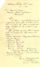
The Ballarat School of Mines held specialist classes for State School Students, including Chemistry and Electricity & Magnetism. Thirty three letters to the Ballarat School of Mines between 1899 and 1904. Some of the correspondence relates to Electricity, Chemistry, Physics and Mineralogy classes for State School students run by the Ballarat School of Mines. The Schools involved were Urquhart Street, Brown Hill, Queen Street, Dana Street, Eureka Street, Mount Pleasant, Sebastopol, Little Bendigo, Mount Clear, Golden Point, Humffray Street, Macarthur Street, Pleasant Street, and Wendouree. .2) Handwritten on lined foolscap paper: 'Golden Point S.S. 1493 10.8.04 F.J. Martell Esq Director, School of Mines, Ballarat Sir, I have much pleasure in informing you that I shall be able to send the full number of boys allotted to my school, viz., seven (7). The following are their names with the subject they desire to take: Walter Sneddon Magnetism & Electricity Cecil Major Magnetism & Electricity Norman Nice Magnetism & Electricity Charles Tinsworth Magnetism & Electricity Leslie Reed Magnetism & Electricity Ernest Booth Magnetism & Electricity David Both Magnetism & Electricity David Birch Chemistry Will you kindly let me know per bearer when the classes will be started. I am Yours respectfully, E.C. Perrin, Head Teacher.' ********* .8) Handwritten on lined paper 'State School 1071 Eureka St, Ballarat East 13/8/04 Sir, In reply to your letter of 8th Inst. I wish to infrom tou that seven boys from teh above school will attend the science classes at teh School of Mines and all of them desire to rak Chemsitry and mineralogy. Yours respectfully R.J. Burke Fred. J Martell Esq.' ********* .22) Eureka St S.S. Ballarat East 23 Aug 1904 Dear Sir, In reply to your last letter I wish to state that Friday afternoon will suit my school the better (for boys attending science lectures) Yours faithfully R.J. Burke F.J. Martell.' ********* .26) Handwritten on lined foolscap paper 'State School 1493 Golden Point 1.9.04 F.J. Martell Esqr. Director School of Mines Sir, The following are the names and classes of the boys from the above school: Charles Tinworth Electricity Ernest Book Electricity Neil Petch Electricity Cecil Major Mineralogy Norman Nice Physics Walter Sneddon Physics David Baird Chemistry Yours faithfully E.C. Perrin, Head Teacher education, school, state school, golden point state school, golden point primary school, eureka street state school, eureka street primary school, perrin, frederick martell, dana street primary school, sebastopol primary school, pleasant street state school, sebastopol state school, mount pleasant state school, mt pleasant state school, mount pleasant, sebsatopol, golden point, charles tinworth, chemistry, electricity, physics, mineralogy, cecil major, norman nice, david baird, walter sneddon, e.c. perrin, leslie reed, ernest booth, david birch, david booth, dana street state school -
 Stawell Historical Society Inc
Archive, Red Cross Records, 1939 - 2004
2 Archive Boxes: Archive Box 18 contains: BAG 1 1 Red Cross First Aid Group. Black Folder 1954 - 1968 Exams 1 Grey Cover July 1944 to April 1945 (Minutes). Group to Disband & Join Red Cross and become Stawell Red Cross Emergency Company. 1 Red Cover - Red Cross Service Company Annual & General Meeting Minutes July 1970 to 1 September 1989. March & September 1978 Meetings abandoned due to insufficient persons attending. 21 September 1989 Meeting called to finalise all Accounts & distribute equipment. BAG 2 1 Plastic Sleeve: Contains 1 X Loose sheets of Miscellaneous Information. 1 Green cover Shell Exercise book - Miscellaneous Information. 1 The Great Blood Bank Evolution with Blood Donor Book Mark. 1 X3 Exercise Books: Monthly List of Donors. 1 Green Cover Shell Exercise Book Aug 1960 - Feb 1968 1 Green Cover Shell Excerise Book April 1968 - July 1979 1 Angle Striped Cover Student Excercise Book Spet - 1979 - March 1982. BAG 3 Blood Bank: Blood Donors & Voluntary Staff at "Blood Takes" 1962 - 1989 1. Blue and White Dimond COver Exercise book: Sept. 1964 - June 1968 1. Blue and White Check with Green Border Embassy Exercise Book: July 1968 - June 1973. 1. Blue Dimond Cover Exercise Book. Aug 1973 - Mar. 1983 1. Red Bound Bound Blue Book. Aug 1with Blood Bank Sticker: April 1983 - June 1989. BAG 4 1 X Bank Statements BAG 5 1. Plastic Bag: 2 Junior Red Cross First Aid Booklets. 1. Grey Cover, Red bound Disaster Times Register & Catering Register. 1. Gordon Exercise Book. Brown Cover Bool Disaster Times & Catering Registers 1984--1988 ( 2 Entries) BAG 6 1. Plastic Sleeve: Assorted Newspaper cuttings, Photos, cerftifcates 3 X Plastic Scapbooks 1961 Mid 1990's BAG 7 1 Plastic Sleeve: Red Cross Recollections Cassette Tape Made By Mrs Rene Hall, Mrs AliceBurton, Mrs Mill Walker, Mrs Jean Hughes; recorded by Elizabeth and2 hand written recollections my Mrs Jean Hughes and Mrs Ivy Newman. 1 Blue Cover Invicta Reservoir Esercise book: Distributing Book: List of Materials and wool supplied to members & What They Made for solders. 1939 - 9/06/1943. 1: Australian Red Cross Knitting Book. 1. Australian Red Cross Victorian Division Pyjamas etc. 1. Small Book Tennis Tournament 1939 with Photocopy of 2 Newspaper Cuttings. BAG 8 1 Plastic Sleeve: 6 News Sheets. 1. Branch Management Book 1940 1. Unit Information Handbook 1985 1 Treasurer's Handbook 1997 1 Office Bearer's Handbook.' 1999 *1 . Stawell Unit Award & Commendation in green folder 1985. 1. Roll of Article from Stawell Times 1,9,1999' 1 Cardboard around wrap for Pewter Wien Goblet sold as a Fundraiser 1. Pewter Bell donated for meeting by Annie N=Neil, and engraved as the Annie Neil Bell 1. Blue Covered book: Study of Red Cross Services ( Stawell Branch) 1939 - 1945 By Christina Joy. * Calico Cloth with Australian Red Cross These were attached to Garments owned by Red Cross. e.g. Short Gowns used at Blood Bank Had one on the Pocket. Archive Bos 19 BAG 1 1 Mottled Black over Red bound. Mon Oct 2 1939 Public Meeting called to form branch in Stawell. Committee meeting to Aug 1946 Page 281. Pages282 - 283 Minutes of Special Meeting: Feb 1942 June 1940 Aug. 1940 2. Public Meeting called to reform the Red Cross Emergency Service 29/07/1942 to 20/03/1970 BAG 2 1: The Original Subscription Book 1939-1940 2: Annual Roll Call Books 1941 1: Gordon Exercise book - Memberships 1941/42 1942/43 2: Membership Rolls: 1944/45 - 1950/51 Membership Rolls 1952/52 - 1959/1960. 1: Red bound Mottled Grey Cover Book - Memberships 1942 - 1968 Sundry Entries 1: Blue Cover Roll Call 1975 - 2002 1: Striped Cover Roll Call 1991 - 2005 1: Membership Subscriptions 2002 - 2004 1 Yellow Cover Office Bearers and Committee Members BAG 3 1 Treasurer's Cash Book 1939 - 1943 1 Receipts & Expenditure 1939 - 1943 1 Red Cover Receipts and Expenditure 1965/66 - 1983 1 Red Bound Receipts and Expenditure 1989 1993 1 Green Cover Receipts & Expenditure 1994 -2003 1 Red and Black Cover Receipts & Expenditire 1995 - 2004 1 White Cash Book 2004 BAG 4 1 Red & Grey Marble cover Red Cross Committe Meeting May 1947 - Oct 1955 2 Special Meeting Minutes: Feb 1951 Nov 1951 1 Brown Bound Minute Book Red Cross Committe Meeting Nov 1955 - Feb 1963 Special Meeting November 1960 1 Red Bound Account Book Used as Minutes March 1963 - Sept 1970. BAG 5 1 Red Bound Black book: Annual Meeting Book 1942- 1989 1 Red Mottled Cover Book Annual Meeting Book 1990 - 2004 BAG 6 1 Red Cover Book: Oct 1970 - June 1978 1 Red Mottled Cover Book: July 1978 - Nov 1987 1 Red Mottled Cover Book July 1996 - May 2004 Tray Cloth with Red Cross Identification Tag Stitched on. (Donated by Graeme McDonough Aug 2010) stawell -
 Ballarat Tramway Museum
Magazine, Melbourne and Metropolitan Tramways Board (MMTB), "MMTB News", 1966
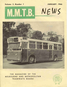
Eight issues of "MMTB News" - The Magazine of the Melbourne and Metropolitan Tramways Board. Two copies of issues 1 to 6 held. Second copy added 31/8/2004. All issues printed with an cream colour paper cover with the rest of the magazine white gloss paper. 2720.1 - Vol. 3, No. 1 - 16 pages, January 1966, with a photo of the Mark VI bus No. 702 on the front cover, notes on Traffic Congestion, motor cars and supermarkets, depot masters, engineering, bus maintenance, sports and social club news. On rear cover includes a photo of a Christmas function with past senior employees - left to right - H. R. Steains (architect), H. S. McComb (Chief Surveyor), Mr. Aird, Mr. P. M. Ireland (Rolling stock engineer), J Fisher (Civil Engineer) and H. A. Warner (Secretary) 2720.2 - Vol. 3, No. 2 - 16 pages, February 1966, with a photo of counting decimal coins, Tribute to the W2 class tram written by Norm Cross, (with photo), Hawthorn Clothing Depot, retirement of Harry Munroe, introduction of decimal currency, donation of 1B bogies to SPER, tramways band, death of Neil Olsen, sports and social club news. See btm2720i9.jpg for image of the Norm Cross photograph. 2720.3 - Vol. 3, No. 3 - 12 pages, March - April 1966, with a photo of Tramways Bowl Tournament presentation on the front cover, Recent developments in public transport in North America, Vera Cruz Mexico, cable cars at Rushworth, sports and social club news and photo of the Melbourne bogies under Sydney tram. 2720.4 - Vol. 3, No. 4 - 16 pages, May 1966, with a photo of W2 321being overhauled at Preston Workshops, change over to decimal currency for accounting machines, "Tram Driver Salutes the L class tram" - written by A. Bailey, Melbourne's New Trams, retirement of Gordon Wilson, sports and social club news. 2720.5 - Vol. 3, No. 5 - 16 pages, June 1966, with a photo of the track relaying in Camberwell Rd with Camberwell fire station in background, Melbourne cable tram routes, opening and closing dates, retirement of G. H. Box, visit of SPER members to Melbourne, memories of Malvern Depot, sports and social club news. 2720.6 - Vol. 3, No. 6 - 16 pages, July - August 1966 with a photo of the view from the St Kilda Junction signal box, more trams for Russia, retirements of 31 Employees, a contest to win an old W2, St Kilda Road Junction box - and how it works - signalling and interlocking, closure of Port Melbourne bus depot, sports and social club news. 2720.7 - Vol. 3, No. 7 - 16 pages, September - October 1966 with a photo of 610 on the Maribyrnong River Bridge, during the SPER tour, "Public Transport in Big Cities" - R. Risson - with photo - see image i10, MMTB Ambulance division, new trams, trams or buses, death of Harry Hood, Chas Samuels, retirement of Jack Ferguson, Reg Maxwell, manufacture of trackwork, cable tram working, sports and social club news. 2720.8 - Vol. 3, No. 8 - 16 pages, November - December 1966 with a photo of a wedding party on a tram (Richards / Fuller), apprenticeship training, Christmas message from the Chairman, tramway canteens, art of rostering by R. Drummond, Wattle Park Chalet, clock and instrument shop at North Fitzroy, tramways band, sports and social club news.Each issue has stamped on the front cover or inside "The Australian Railway Historical Society (S.A. Branch).trams, tramways, mmtb, sper, wattle park, port melbourne, st kilda junction, decimal currency, w2 class, l class, hawthorn -
 Bendigo Military Museum
Photograph - Flag Day – Various Sports, Army Survey Regiment Verses School of Military Survey, Bendigo, 1977
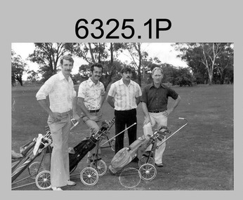
These 15 photographs of golf, sailing, rifle shooting and squash team and sports action were taken on Flag Day, an annual sports competition between the Army Survey Regiment (ASR) and the School of Military Survey (SMS), at Bendigo on the 13th of May 1977. Sailing was most likely held at Lake Eppalock and rifle shooting at Wellsford Rifle Range. The venues for golf and squash are unknown. The two RA Svy units took turns each year to host the event. The day competition usually comprised basketball, cross country, golf, sailing, squash softball, tennis, rifle shooting, touch football, tug-of-war and volleyball. The evening competition often included darts, carpet bowls, hookey, quoits and snooker. See item 6025.15P for photos of softball team and sports action taken on the day.This is a set of 15 photographs of golf, sailing, rifle shooting and squash team and sports action was taken on Flag Day, Army Survey Regiment (ASR) versus the School of Military Survey (SMS), at Bendigo on the 13th of May 1977. The photographs were printed on photographic paper and are part of the Army Survey Regiment’s Collection. The 35mm positive photographic proofs were scanned at 600 dpi. .1) - Photo, black & white, 1977, Golf - L to R: Kevin ‘Chuck’ Berry, George Austen, unidentified, Roy Morgan. .2) - Photo, black & white, 1977, Golf - L to R: Stan Vote, Gordon Lowery, Peter Warwick, John ‘JB’ Barrie. .3) - Photo, black & white, 1977, Golf - L to R: Peter Warwick, John ‘JB’ Barrie. .4) - Photo, black & white, 1977, Golf - unidentified. .5) - Photo, black & white, 1977, Sailing – Back row L to R: Chris Osborne, Josh De Groot, unidentified (x2), Greg Francis-Wright, Peter Breukel. 3rd row L to R: Marrianne (Van De Zee) De Groot, unidentified, Kim Reynolds, Alex Cairney, unidentified. 2nd row L to R: Les Dixon, Jim Macdonald, unidentified, George Graham, Ted ‘FOT’ Burgess. Front row L to R: Doug Carswell, Allan Adsett, Peter Mustart, Tony Waldon. .6) - Photo, black & white, 1977, Sailing – Back row L to R: Chris Osborne, Josh De Groot, unidentified (x2), Greg Francis-Wright, Peter Breukel. 3rd row L to R: Marrianne (Van De Zee) De Groot, unidentified, Kim Reynolds, Alex Cairney, unidentified, Sam Chambers. 2nd row L to R: Les Dixon, Jim Macdonald, unidentified, George Graham, Ted ‘FOT’ Burgess. Front row L to R: Doug Carswell, Alan Adsett, Peter Mustart, Tony Waldon, Dave Miles. .7) - Photo, black & white, 1977, Sailing on Lake Eppalock, Victoria. .8) - Photo, black & white, 1977, Shooting – unidentified, 2nd back right: Tony Lawler. .9) & .10) - Photo, black & white, 1977, Shooting - Back row L to R: Paul Davis, unidentified (x2), Max Neil, Rhys De Laine. Front row L to R: Tony Lawler, Rene van den Tol, unidentified, Warren ‘Waldo’ Shirley. .11) & .12) - Photo, black & white, 1977, Shooting - Back row L to R: John Ashby, unidentified (x3). Front row L to R: Dave Murphy, Wolfgang Thun, John ‘Stormy’ Tempest, unidentified. .13) - Photo, black & white, 1977, ASR Squash Team– Back row L to R: Andy Wilson, Terry Danger, Errol Fletcher, Dennis Puniard. Front row L to R: Lynn Johnson, Kerry Browne. .14) - Photo, black & white, 1977, SMS Squash Team – Back row L to R: Graham Squire, Peter Constantine AM, Peter Colwell, Bill Boyd OAM, Front row L to R: unidentified, Dick Barwald, Colin Darch, unidentified. .15) - Photo, black & white, 1977, ASR Squash Team –Terry Danger..1P to .15P –No personnel are identified.royal australian survey corps, rasvy, army survey regiment, army svy regt, fortuna, asr, school of military survey, flag day -
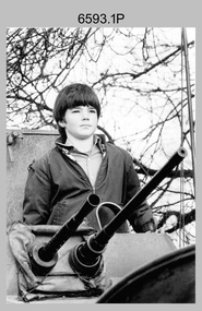 Bendigo Military Museum
Photograph - Miss Golden North Charity Queen - 2LT Kathie Ryan Army Survey Regiment, Fortuna, Bendigo, 1985
This is a set of 12 photographs of the Army Survey Regiment’s winning entrant in the Miss Golden North Charity Queen quest - 2LT Kathie Ryan, taken on three occasions in 1985. The following article was compiled by the unit summarising her campaign. ‘On Friday 20 September 1985, 2LT Kathie Ryan of the Army Survey Regiment, Bendigo, faced a selection panel of a different kind. Kathie is an entrant in this years Miss Australia Quest and is sponsored by her unit. Together with seven other girls from Central Victora, Kathie vied for the Regional Title of Miss Golden North, held on 20 September 1985. With enthusiastic shouts of joy from the members of the Regiment present, Kathie Ryan was crowned Miss Golden North 1986. She is now one of 19 finalists contesting the title “Miss Victoria 1986”. “It has been a very rewarding experience being involved in raising money for such a worthwhile cause” said Kathie. “Organisations such as the Spastic Society, have a very important role in helping people with disabilities. To be involved with this society has been both enjoyable and a great learning experience”. The aim of the Miss Australia Quest is to raise funds for the Spastic Society of Australia. Kathie entered the Quest in March then, together with her committee, started to raise money. Over the next seven months, many fund-raising activities were conducted. These included an Open Day at the Army Survey Regiment, a Bingo night, several raffles, and several tin shakes in the streets of Bendigo as well a participating in several of the functions organised at a Regional or State level in the name of the Spastic Society. The total raised this year was in excess of $11,500. The Army Survey Regiment has now had 3 entrants in the Miss Australia Quest since 1981 and has raised over $23,000 for the Spastic Society in that time’ An abbreviated article with photo 6593.4P was published on page 12 of the Army Newspaper on 28 November 1985. Two articles with photographs were published in the Bendigo Advertiser Newspaper on 23 September and 30 October 1985. Clippings from these newspapers, a detailed breakdown of the funds raised during the campaign and the Army Survey Regiment’s Open Day Administrative Instruction are stored with these photographs. The Open Day was held on the weekend of 24-25 August 1985. Activities included static displays of armoured vehicles, map production displays, Army recruiting displays historical tours of Fortuna Villa, refreshments including Devonshire Teas, craft stalls, live music and children's rides.This is a set of 12 photographs of the Army Survey Regiment’s winning entrant in the Miss Golden North Quest - 2LT Kathie Ryan, taken on three occasions in 1985. The photographs were printed on photographic paper and are part of the Army Survey Regiment’s Collection. The colour and black and white photographs were scanned at 300 dpi. Included in this set are negatives of photo 6593.4P, 6593.5P and 6593.6P. .1) - Photo, black & white, Open Day 23-24 Aug 1985. Unidentified visitor on APC vehicle. .2) - Photo, black & white, Open Day 23-24 Aug 1985. Unidentified pipe band performs in front of APC vehicle. .3) - Photo, black & white, Open Day 23-24 Aug 1985. View of Fortuna Villa. .4) - Photo, black & white, Miss Australia Quest Presentation at All seasons Motor Inn 20 Sep 1985. 2LT Kathie Ryan crowned Miss Golden North Queen by former holder of the title Miss Celine Hull. Unidentified compere in background. .5) - Photo, black & white, Miss Australia Quest Presentation at All seasons Motor Inn 20 Sep 1985. 2LT Kathie Ryan reacts winning the Miss Golden North Queen. Winner of the Miss Golden North Charity Queen title Miss Noelene Earle is on her right. .6) - Photo, black & white, Miss Australia Quest Presentation at All seasons Motor Inn 20 Sep 1985. Title winners L to R: Miss Golden North Charity Queen - Noelene Earle, Miss North-West/Sunraysia & Charity Queen – Jo-Anne Collier and Miss Golden North Queen - 2LT Kathie Ryan. .7) & .8) - Photo, colour, Miss Australia Quest Presentation at All seasons Motor Inn 20 Sep 1985. 2LT Kathie Ryan is escorted to the ceremony dais by LT Greg Oaten. .9) - Photo, colour, Miss Australia Quest Presentation at All seasons Motor Inn 20 Sep 1985. 2LT Kathie Ryan with her escorts L to R: LT Greg Oaten and CAPT Neil Taylor. .10) - Photo, colour, Miss Australia Quest Presentation at All seasons Motor Inn 20 Sep 1985. Miss Golden North Queen 2LT Kathie Ryan with her organising committee L to R: SPR Sherri (Dally) Burke, WO2 Pat Lumsden, RSM WO1 Bob Mason, 2LT Kathie Ryan, MAJ Alex McLennan - President, SPR Gae (Robinson) Amato – Secretary, CPL Mick Minchin – Treasurer. .11) - Photo, colour, 1985. MAJ Alex McLennan presents 2LT Kathie Ryan with the Miss Golden North Queen prizes she had won at a celebration BBQ. In background L to R: SPR Wally Twidale, unidentified, SPR Dave Lambton-Young, SPR Jann (Caithness) Lambton-Young, unidentified, Mrs Pam Mason, WO2 Pat Lumsden. .12) - Photo, colour, 1985. L to R: MAJ Alex McLennan, Miss Golden North Queen 1985 Miss Celine Hull, CO LTCOL Jorge Gruszka, CPL Mick Minchin, Miss Golden North Queen 1986 2LT Kathie Ryan. 2x unidentified ladies in background double exposure.‘Miss Australia Quest 1985' annotated on cover sleeve. .7P to .11P – names annotated on back of photographs. ’15 October 1985’ annotated on back of photographs .7P to .9P is probably incorrect, based on other reports and newspaper articles. royal australian survey corps, rasvy, army survey regiment, army svy regt, fortuna -
 Bendigo Historical Society Inc.
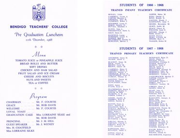
Document - LA TROBE UNIVERSITY BENDIGO COLLECTION: BENDIGO TEACHERS' COLLEGE PRE GRADUATION LUNCHEON 1968
A white document titled Bendigo Teachers' College. Pre Graduation Luncheon. 11th December, 1968. Below the title is a copy of the Menu being offered and an outline of the Program: Chairman - Mr. F. Courtis. Grace - Mr. Rob Davis. Welcome - Mr. F. Courtis. Loyal Toast and Graduation cake - Miss Lorraine Silke and Mr. Rob Davis. Principal - Mr. J. M. Hill. Guest Speaker Mr. J. Witney. Also included Mrs. H. Chatfield and Miss Lorraine Silke. On the back of the card is a list of the Students of 1966 - 1968. Trained Infant Teacher's Certificate: Linda Boxall, Carole A. Campbell, Maureen J. Carter, Alice M. Chiswell, Robyn J. Clemson, Lynn F. Dewhurst, Rosslyn D. Doble, Elizabeth J. Duvall, Nola L. Flynn, Dawn E. Freemantle, Dawn E. Gray, Louise Hadfield, Laurel Y. Harrison, Beth A. Harrop, Jennifer N. Hildebrand, Merren J. Hurlston, Helen M. Jasper, Glenise F. King, Rosalie D. King, Wendy J. Lanyon, Anne T. Luddington, Bernadette M. Moore, Judith M. Olsen, Cheryl D. Peace, Janet E. Pollock, Glenda J. Ritchie, Sandra F. Ross, Patricia Scott, Lorraine M. Silke, Kaye E. Speers and Robyn M. Walker. Students of 1967 - 1968. Trained Primary Teacher's Certificate: Garry D. Aitchison, David C. Allsop, Susan M. Blacket, Leonie J. Bock, Coral M. Brown, Glenys M. Brown, Helen E. Campbell, Merril A. Campbell, Dianne J. Cheong, Roslyn O. Chisholm, Lloyd R. Christopher, Therese A. Curran, Tanyth M. Dainton, Robert J. Davis, Elaine Duncanson, Janice Eddy, Joyce P. Evans, Kerrie F. Featherston, Heather F. Fehring, M. Selby Fidler, E. R. Lia Filisone, Lindsay J. Fisher, Jennifer K. Goode, Kaye D. Gribben, Patricia J. Grigg, Susan A. Haines, Rhonda M. Hall, Mary J. Hallinan, Raymond C. Harvey, Neil J. Harrington, Robin C. Hill, Gayle L. Hinks, Carol A. Hitchens, Aileen M. Hooley, Susan M. Hunt, J. Maree Hutchins, Rhonda E. Jobling, Cherrill J. Johnson, Roslyn M. Jordan, Leonard J. Jude, Mary Kappadais, James C. Kennedy, Cheryl A. Little, Helen M. Lynas, Brian D. McDonald, Elaine T. Mace, Patricia Mackin, Christine E. Maddern, Michael J. Maher, Janet F. Markey, Averil N. Miles, Helen A. Moait, Kenneth D. Molyneux, Edna M. Morrison, Jillian M. Morrison, Noelene E. Morrison, Marilyn F. Nadenbousch, Christine D. Napier, Sandra Nesbit, Maxine J. Nicolson, Jane L. Nisbet, Jeanette M. Norman, Shane J. O'Brien, Jillian R. Ogden, John G. Pease, Pauline E. Peck, Peter C. Powles, Denise M. Quinn, Georgia A. Radcliffe, John Reid, Kaye Retallick, Glenice W. Rice, Kirtis R. Richards, Judith H. Richards, Pamela M. Schroeter, Marjorie R. Shaw, Christopher F. Sharpley,Beverly L. Smith, M. Anne Stuchbery, Heather Sutherland, Elaine R. Sutton, Ian H. Taylor, Julie A. Thirwell, Margaret A. Thomas, Jennifer R. Thorne, Faye E. Tonkin, Rosemary D. Turner, Robert R. Walsh, Helen J. Watt, Glenda K. Wilson and Eugeniusz Zolnieczyk.bendigo, education, bendigo teachers' college, la trobe university bendigo collection, collection, bendigo teachers' college, bendigo, education, teaching, teachers, students, menu, graduation luncheon, lunceon, tertiary education, graduates, graduands, graduation, bendigo teachers' college staff, bendigo teachers' college students -
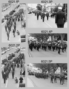 Bendigo Military Museum
Photograph - Army Survey Regiment Freedom of Entry Parade, 1980
The Freedom of Entry to the City was an honour conferred by the Bendigo City Council to the Army Survey Regiment in 1970. 1980 was the third time the unit exercised its freedom of marching into the city with swords drawn, bayonets fixed and drums beating. The honour is usually bestowed upon local regiments, in recognition of their dedicated service, and it is common for military units to periodically exercise their freedom by arranging a parade through the city. Led by the Regiment’s CO – LTCOL Bob Skitch, the unit marched down View St in the CBD, along Pall Mall and up Gaol Rd to the Queen Elizabeth II Oval. The ceremonial parade followed with a march past the guests of honour, Mayor of Bendigo Councillor Paul Tomkinson and military dignitaries. The parade concluded after formal inspections of the troops. The Regiment also exercised its Freedom of Entry with anniversary parades in 1977, 1980, 1985, 1990 and 1995.These black and white photographs of the Army Survey Regiment were taken on the occasion of the Freedom of Entry parade to the City of Bendigo in 1980. The photographs were printed on photographic paper and are part of the Army Survey Regiment’s Collection. The photographs were scanned at 300 dpi. .1) Photo, black & white, L to R: MAJ Don Swiney, LTCOL Bob Skitch, WO1 Aub Harvey, unidentified, photographer in foreground – SGT Garran Hill .2) Photo, colour, black & white, L to R: MAJ Don Swiney, LTCOL Bob Skitch, WO1 Aub Harvey, unidentified .3) Photo, black & white, L to R: MAJ Don Swiney, WO1 Aub Harvey, LTCOL Bob Skitch, unidentified .4) Photo, black & white: 3rd MD Band .5) Photo, colour, L to R: MAJ Don Swiney, WO1 Aub Harvey, LTCOL Bob Skitch, unidentified .6) Photo, black & white, L to R: MAJ Don Swiney, WO1 Aub Harvey, unidentified, LTCOL Bob Skitch .7) Photo, black & white, L to R: SGT Stu Thaxter, LT Neil Taylor, CAPT Bob Roche .8) Photo, black & white, L to R: SPR Per Andersen – right marker .9) Photo, black & white, L to R: MAJ Peter Eddy .10) Photo, black & white, L to R: CPL Frank Lenane, CPL Flash Anderson, SGT Rhys De Laine, SPR Per Andersen .11) Photo, black & white, L to R: Mayor Paul Tomkinson .12) Photo, black & white, L to R: MAJ Don Swiney, WO1 Aub Harvey, unidentified, LTCOL Bob Skitch .13) Photo, black & white, L to R: unidentified personnel .14) Photo, black & white, L to R: unidentified personnel .15) Photo, black & white, L to R: unidentified personnel .16) Photo, black & white, L to R: unidentified personnel .18) Photo, black & white, L to R: CAPT Paddy Strunks, Mayor Paul Tomkinson, LTCOL Bob Skitch .19) Photo, black & white, L to R: Mayor Paul Tomkinson, CPL Bill Jones, CPL Gary Drummond, WO2 Tom Pattison .20) Photo, black & white, L to R: CAPT Paddy Strunks, WO1 Aub Harvey, Mayor Paul Tomkinson, SGT Rick Warren, CPL Andy Wilson …, WO2 Ted Burgess .21) Photo, black & white, L to R: LTCOL Bob Skitch, SPR Roy Hicks, Trevor Osborne, SPR Paul Baker, CAPT Stan Vote, CPL Bill Jones, Greg Francis-Wright .22) Photo, black & white, Air Survey Squadron inspection. Rear rank: SSGT Russell ‘Rusty’ Williams. Centre rank L to R: CPL Peter Treble, SGT Jim Beard, SPR Peter Hardy, SPR Steve Hilton, SPR John Lane, CPL Mick Hogan, Mayor – Councillor Paul Tomkinson. .23) Photo, black & white, L to R: Mayor Paul Tomkinson, CPL Marrianne (Van De Zee) De Groot, SPR Cathy Regan, SPR Ginny Turner, SPR Ilen Isaac, SPR Penny Knott, SPR Santina Argetto, SPR Gina Coore .24) Photo, black & white, L to R: Mayor Paul Tomkinson, SPR Cathy Regan, SPR Ginny Turner, SPR Ilen Isaac, SPR Penny Knott, SPR Santina Argetto, SPR Gina Coore, WO2 Pat Lumsden .25) Photo, black & white, L to R: LTCOL Bob Skitch, Mayor Paul Tomkinson, SPR Ilen Isaac, SPR Penny Knott, SPR Santina Argetto, SPR Gina Coore, WO2 Pat Lumsdenroyal australian survey corps, rasvy, fortuna, army survey regiment, army svy regt, asr -
 Bendigo Historical Society Inc.
Book - BENDIGO SALEYARDS COLLECTION: RECORD OF TOKENS
BHS CollectionPale green covered exercise book with Victory printed in orange at the top right. Below is a circle with Victory at the top and Natural below. Across the centre is 100% Recycled Paper. Below is 96 page printed in white on an orange background. Below that is Exercise Book printed in dark green, and below that is the name plate. On the name line is a date 31-10-91. Book was used as a record of who bought tokens for the truckwash and how much they paid. Later the money was paid to the Council. Names in the book included: Robt Blake, Gib Davey,M Tappe, John Wilson, Allan Somerville, Peter Harris, ? Hearn, Andrew Beer, Jack McKenna, Don White, J Govett, J Wignall, Matthews Transports, Pickthalls Transport, Carlisle Bros, Noel Hartland, Grogans Livestock, K Stratton, Rutlands Transports, J Truscott, Des Byrne, Commercial Pig Co, Rick Thompson, M Connally, K Otoole, B McLean, K Stevens, S Bennitt, Alan Pickdall, L Boyd, Mathews Transport, Mathews, Cowan Transport, H J Sooble, John Kerr, Stone, John Wilson, Brendan Morgan, Bruce Stewart. Jack Covett, Len Terry, Neil Adams, P Llewellyn, Peter Norris, Steve Nann, Glen Bish, R Frazer, Rutland, S Johnston, R Hearn, Ronald D Stone, Stephen Bennett, Nick Connally, Wayne Wignall, G Chapman, Noel Hartland, Stan Rutland, Mr Preston, K Barrow, John Wilson, Mr McGrath, W Lanz, John Truscott, Craigs, M Vick, Craig Hoy, Cliff Johnson, N Johnson, Sullivan, Colin Bloomfield, R Thompson, M Vick, Jan Wignall, Bicknalls, JJ Wilson, Des Byrne, Keith O'Toole, Llewellyns transports, Reg Hearn, Don White, J Boon, Mr Webb, W Fergson, Glen Bish, G Pollock, Penview Pastoral Co, G Pollock, Meehan, Woodstock Holdings, J W Pekthall & Sons, John Wilson, Kerrs Transports, K Stevens, John Kerr, Benview Elmore, Steve Mann, Mr Anfuso, K Wignall, D Fawcett, P Johnson, Llewingtons, R Hearn, Paynes Transports, G Watson, Ian Johnson, G G Muller & Son, Pichard O'Sullivan, Gib Davies, Adams Transport, Kevin Marlow, Lewington, Maurie Bick, Isaac, Des Byrne, Lewington, J Govett, N Hartland, S Bennett, J Govett, R Thompson, B Morgan, Colin Bloomfield, J Kerr, Mr Carver, Richards, K Isaac, Amfuso, Bob McLean, Mr Marke, Geodie, Ted Goddard, Kulpinski, Hollingworth, W Hodge, G F Farmer, R Hearn, Kevin Stevens, Don White, Morrie Vick, Mr Gallagher, R McKenzie, L Lanz, L Kirk, D Harrigan, RG & F Moon, E J Hooper, Des Byrne, G Medlyn, J Wilson, N Hartland, H Green, D Vick, G D Gamble, Con Mulvahill, Pietorala Transports, C Reece, Graham Miller, Rinaldi, Les Smith, Brendan Morgan, Pickhalls Transports, Mr Dawn, Steven Bennett, Steve Mann, Les Smith, H Green, Connallys, Lewington, I Gallagher, Ray Collins, Burrow, Hugh Green, C Congrim, D Byrne, Don White, grogan, Mr Selly, Adams Transports, Kevin Marlow, Roberts Transports, J W Pickhalls, Wick Lockington, G Bish, Don White, GG Muller & Son, McKenna's, T Smith G Watson, Blacky, B Lee, Don Wright, Hue Green, John Wilson, Carl Cooke, Mr Connally, N Northland, Jan Hollingsworth, Mr Preston, Mr Hooper, Mr Rose, D White, Ron Mellier, GD Gamble, K Richards, Bond Bros, J Govett, Victorian Producers, Gavin O'Sullivan, Neil Adams, Mr Dowell, I Gallagher, W Lanz, Mr Boyd, Peter Bish, J McKay, Farmer, Joe Blow, J Matthews, M Vick, N Adams, Colins Pastoral Co, Younghusband, K Barrow, K Richards, Steve Bennett, Les Smith, Ben Webb, John Wilson, Gavin O'Sullivan, Mr McCarthy, Col Warrack, Steve Ellis, Charlie Reece, Mr Vanderene, D Hannagan, P Morgan, Don White, Sommerville, McDonald, P Meighan, Don White, Les Smith, Carl Koch, Ron Stone, M Connally, J Gover, Mr Craig, M Vick, Eddy Smith, B Morgan, B Hickson, Len Reid, Mr Curt, Mr Grogan, Rob Blake, Mr Goulthorpe, Bob McLean, O'Sullivans, Ricky thompson, Johnson, Mr Coffey, J McKay, D White, Giles, Johnstone, Nicholls, Govett, White, Wilson, Don White, Geoff Gill, D Gorden, Ray Collins, Pellegrino, Cory Watson, W Ferguson, Pickthall, McDonald, Cook, S Mann, J Govett, Collins Pastral, Broad, Rick thompson, R Hearn, S Bennett, W Fitzpatrick, Noel Hartland, K Rotheran, David Beers, Congran, R Blake, R Weeks, Taylor, R Frazer, K Stratton, M Connally, N Adams, Don White, Milgate, Findlays, J Dury, McKibbins, Morgan, Roberts, R Stone, K Stevens, M Vick, C Reece, Steve Bennett, Ahern, S Boyd, Rick thompson,McClean, Hearn, Govett, Peter harris, Graham Medlyn, McAllister, Noel Hartland, Beer, RJ Grogan, Hindle, Bendigo Horse Transport, Jack McKenna, R Hearn, J McKay, T Rinaldi, Hayes, G Muller, J Govett, Ranoldi, D Ford, K O'Toole, J Talbot, McKibbons, Barr, S Bennett, P Johnston, J Hird, Paynes Transport, D White, P Harris, Maurie Vick, P Bish, Don Hollingsworth, C Gilmore, Jack Talbot, G Chapman, J Wilson, Kevin Stevens, Eddy Smith, C Bloomfield, R thompson, Davies, Truscott, D Byrne, Hayes Transport, Yanga Pty Ltd, M Connally, A Rothacker, Coad, D Byrne, R O'Sullivan, K Stevens, Cliffton, M Douglas, Trevor Mathews, Botly, Anufson, w Fitzpatrick, R Hearn, R Collins, Craig Dorman, Brian Bentley, M Johns, T Sully, W Fawcett, Bob McLean, D White, Hugh Green, B Harris, Rod thompson, P Meighan, Allan McAllister, Mark Barri, Don White, M Connelly, P Lewellyn, G Gill, G Rand, Hayes, S O'Sullivan, D White, Bob Blake, R Stone, B Liddle, Bentley Trans, J Govett, Stevens Transport, N Broad, Govett, G Young, M Footh, Geoff Gill, Gamble, D Holingworth, C Reece, S White, S Bennett, M Barri, John Wilson, D Byrne, P Morgan, R Stone, Bentley, Pollock, Des Byrne, Doug Rinaldi, J Govett, B Harris, R Brunt, Roberts, R Burt, Tang, Peter Morgan, M Oxley, G W Nunn, D Boyd, Findley, C Johns, W Craig, A Beer, A & M Rinaldi, D Illingworth, M Barri, G Rand, G & P Nunn, R Hearn, A Broad, C Bloomfield, K Marlow, P Trailer, J Govett, Talbot, J Beer, M Gray, J Kerr, R Stone, R Stewart, English Trans, Argyle Transport, Bentley's, B Stewart, G Davey, Leavinitons, Lewington's, Miller, G Muller, J Talbot, S Mann, McKibbins, Hanson, D Boon, R Burt, English, Oxley, N Collier, Broadacres, Murphy, M Oxley, G Thomas, Holly, Dalgety, Elders, McKean, Nevins, Nuttall, Rodwell, Vains, VPC, Allan MacAllister, Hyland, Gathercole, Gilbertson, Hardwick, Le frankie, Midfield, Osullivans Wignall, John Crimmins, D Lane and Jack Fisher.bendigo, council, cattle markets, bendigo saleyards collection - record of tokens, robt blake, gib davey, m tappe, john wilson, allan somerville, peter harris, ? hearn, andrew beer, jack mckenna, don white, j govett, j wignall, matthews transports, pickthalls transport, carlisle bros, noel hartland, grogans livestock, k stratton, rutlands transports, j truscott, des byrne, commercial pig co, rick thompson, m connally, k otoole, b mclean, k stevens, s bennitt, alan pickdall, l boyd, mathews transport, mathews, cowan transport, h j sooble, john kerr, stone, john wilson, brendan morgan, bruce stewart. jack covett, len terry, neil adams, p llewellyn, peter norris, steve nann, glen bish, r frazer, rutland, s johnston, r hearn, ronald d stone, stephen bennett, nick connally, wayne wignall, g chapman, noel hartland, stan rutland, mr preston, k barrow, john wilson, mr mcgrath, w lanz, john truscott, craigs, m vick, craig hoy, cliff johnson, n johnson, sullivan, colin bloomfield, r thompson, m vick, jan wignall, bicknalls, jj wilson, des byrne, keith o'toole, llewellyns transports, reg hearn, don white, j boon, mr webb, w fergson, glen bish, g pollock, penview pastoral co, g pollock, meehan, woodstock holdings, j w pekthall & sons, john wilson, kerrs transports, k stevens, john kerr, benview elmore, steve mann, mr anfuso, k wignall, d fawcett, p johnson, llewingtons, r hearn, paynes transports, g watson, ian johnson, g g muller & son, pichard o'sullivan, gib davies, adams transport, kevin marlow, lewington, maurie bick, isaac, des byrne, lewington, j govett, n hartland, s bennett, j govett, r thompson, b morgan, colin bloomfield, j kerr, mr carver, richards, k isaac, amfuso, bob mclean, mr marke, geodie, ted goddard, kulpinski, hollingworth, w hodge, g f farmer, r hearn, kevin stevens, don white, morrie vick, mr gallagher, r mckenzie, l lanz, l kirk, d harrigan, rg & f moon, e j hooper, des byrne, g medlyn, j wilson, n hartland, h green, d vick, g d gamble, con mulvahill, pietorala transports, c reece, graham miller, rinaldi, les smith, brendan morgan, pickhalls transports, mr dawn, steven bennett, steve mann, les smith, h green, connallys, lewington, i gallagher, ray collins, burrow, hugh green, c congrim, d byrne, don white, grogan, mr selly, adams transports, kevin marlow, roberts transports, j w pickhalls, wick lockington, g bish, don white, gg muller & son, mckenna's, t smith g watson, blacky, b lee, don wright, hue green, john wilson, carl cooke, mr connally, n northland, jan hollingsworth, mr preston, mr hooper, mr rose, d white, ron mellier, gd gamble, k richards, bond bros, j govett, victorian producers, gavin o'sullivan, neil adams, mr dowell, i gallagher, w lanz, mr boyd, peter bish, j mckay, farmer, joe blow, j matthews, m vick, n adams, colins pastoral co, younghusband, k barrow, k richards, steve bennett, les smith, ben webb, john wilson, gavin o'sullivan, mr mccarthy, col warrack, steve ellis, charlie reece, mr vanderene, d hannagan, p morgan, don white, sommerville, mcdonald, p meighan, don white, les smith, carl koch, ron stone, m connally, j gover, mr craig, m vick, eddy smith, b morgan, b hickson, len reid, mr curt, mr grogan, rob blake, mr goulthorpe, bob mclean, o'sullivans, ricky thompson, johnson, mr coffey, j mckay, d white, giles, johnstone, nicholls, govett, white, wilson, don white, geoff gill, d gorden, ray collins, pellegrino, cory watson, w ferguson, pickthall, mcdonald, cook, s mann, j govett, collins pastral, broad, rick thompson, r hearn, s bennett, w fitzpatrick, noel hartland, k rotheran, david beers, congran, r blake, r weeks, taylor, r frazer, k stratton, m connally, n adams, don white, milgate, findlays, j dury, mckibbins, morgan, roberts, r stone, k stevens, m vick, c reece, steve bennett, ahern, s boyd, rick thompson, mcclean, hearn, govett, peter harris, graham medlyn, mcallister, noel hartland, beer, rj grogan, hindle, bendigo horse transport, jack mckenna, r hearn, j mckay, t rinaldi, hayes, g muller, j govett, ranoldi, d ford, k o'toole, j talbot, mckibbons, barr, s bennett, p johnston, j hird, paynes transport, d white, p harris, maurie vick, p bish, don hollingsworth, c gilmore, jack talbot, g chapman, j wilson, kevin stevens, eddy smith, c bloomfield, r thompson, davies, truscott, d byrne, hayes transport, yanga pty ltd, m connally, a rothacker, coad, d byrne, r o'sullivan, k stevens, cliffton, m douglas, trevor mathews, botly, anufson, w fitzpatrick, r hearn, r collins, craig dorman, brian bentley, m johns, t sully, w fawcett, bob mclean, d white, hugh green, b harris, rod thompson, p meighan, allan mcallister, mark barri, don white, m connelly, p lewellyn, g gill, g rand, hayes, s o'sullivan, d white, bob blake, r stone, b liddle, bentley trans, j govett, stevens transport, n broad, govett, g young, m footh, geoff gill, gamble, d holingworth, c reece, s white, s bennett, m barri, john wilson, d byrne, p morgan, r stone, bentley, pollock, des byrne, doug rinaldi, j govett, b harris, r brunt, roberts, r burt, tang, peter morgan, m oxley, g w nunn, d boyd, findley, c johns, w craig, a beer, a & m rinaldi, d illingworth, m barri, g rand, g & p nunn, r hearn, a broad, c bloomfield, k marlow, p trailer, j govett, talbot, j beer, m gray, j kerr, r stone, r stewart, english trans, argyle transport, bentley's, b stewart, g davey, leavinitons, lewington's, miller, g muller, j talbot, s mann, mckibbins, hanson, d boon, r burt, english, oxley, n collier, broadacres, murphy, m oxley, g thomas, holly, dalgety, elders, mckean, nevins, nuttall, rodwell, vains, vpc, allan macallister, hyland, gathercole, gilbertson, hardwick, le frankie, midfield, osullivans wignall, john crimmins, d lane, jack fisher -
 Bendigo Military Museum
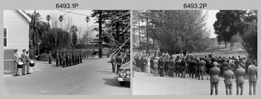
Photograph - Military Funeral for SSGT Peter Dew, Army Survey Regiment, Fortuna, Bendigo, 1977
This is a set of 29 black & white photographs of troops from the Army Headquarters Survey Regiment undertaking ceremonial drill at the military funeral for SSGT Peter Dew on the 28th of September 1977. The location of the funeral service was at Fortuna, Bendigo. He was buried at Bendigo Cemetery in Quarry Hill. Peter Dew died in a tragic accident at home. He was fondly remembered as one of Lithographic Squadron’s colourful personalities. See item 6243.7P for photos of Peter Dew at work in Lithographic Squadron. The "Super Animal of the Year" Peter Dew Memorial Award was an award presented to a member of the squadron for a crude act. To view a photo of this award, refer to item 6230 of the Victorian Collections. Some photos in this set were also printed on photo paper and catalogued under item 6335.5P.This is a set of 29 black & white photographs of troops from the Army Headquarters Survey Regiment undertaking ceremonial drill at the military funeral for SSGT Peter held in 1977. The photographs are on 35mm negative film and scanned at 96 dpi. They are part of the Army Survey Regiment’s Collection. .1) - Photo, black & white, 1977. Rifle party commander: CPL Greg Kidman. Right file right marker: SPR Russ Mollenhauer, unidentified soldiers and civilians. .2) - Photo, black & white, 1977. Unidentified soldiers and civilians. .3) - Photo, black & white, 1977. R to L: SSGT Alan Adsett, WO2 John McCulloch, SGT Graeme Jeffers in foreground holding hats. Remainder unidentified. .4) to .6) - Photo, black & white, 1977. Unidentified soldiers and civilians. R to L: SSGT Alan Adsett, WO2 John McCulloch, unidentified soldiers and civilians. .7) - Photo, black & white, 1977. Pall bearers position the coffin onto the gun carriage. Rifle party commander: CPL Greg Kidman. Right file right marker: SPR Russ Mollenhauer. Seen in background to the right of pall bearers: L to R: CPL Ian Belmont, unidentified, facing away- PTE Le-anne (Smallshaw) Shirley, CPL Di Chalmers, unidentified soldiers and civilians. .8) - Photo, black & white, 1977. Rifle party rear rank right marker: Russ Mollenhauer. Front rank rifle party commander next to right marker: Greg Kidman. Pall bearers in front of vehicle L to R: Dave Miles, Dick Barwald. Remainder unidentified. .9) - Photo, black & white, 1977. In position at beginning of funeral procession, unidentified soldiers and civilians. .10) & .11) - Photo, black & white, 1977. Rifle party commander: CPL Greg Kidman and the rifle party slow march past the front of Fortuna Villa. .12) - Photo, black & white, 1977. The rifle party slow march past the front of Fortuna Villa. Rifle party commander: Greg Kidman. Right file front to back: SPR Russ Mollenhauer, SPR Peter Breukel, SPR Bill Jones, SPR John Anderson. Remainder unidentified. Left file front to back: SPR Jeff Willey, unidentified, SPR Rhys De Laine, SPR Frank Lenane, SPR Josh Degroot, SPR Gary Drummond. .13) - Photo, black & white, 1977. The rifle party slow march past the front of Fortuna Villa. Rifle party commander: Greg Kidman. Right file: SPR Russ Mollenhauer, Left file: SPR Jeff Willey, remainder unidentified. .14) - Photo, black & white, 1977. The rifle party march at quick time towards the entry gate. .15) - Photo, black & white, 1977. The rifle party march at quick time past the front of Fortuna Villa. Rifle party commander: Greg Kidman. Right file: SPR Russ Mollenhauer, Left file: SPR Jeff Willey, remainder unidentified. .16) - Photo, black & white, 1977. The procession marches at quick time towards the entry gate. .17) - Photo, black & white, 1977. The procession departs the entry gate. .18) to .21)- Photo, black & white, 1977. The procession passes through the cemetery. .22) - Photo, black & white, 1977. The procession passes through the cemetery. RSM Wo1 Aub Harvey at far left. Remainder unidentified. .23) - Photo, black & white, 1977. Pallbearers carry Peter Dew’s coffin to the grave site. .24) - Photo, black & white, 1977. The rifle party in position at ‘rest on arms reverse’. .25) - Photo, black & white, 1977. Service at grave site. Left of minister: SGT Alan Toogood. On right of tree L to R: WO2 Max Neil, WO2 Bob Hayden, WO1 Dave Malligan, PTE Le-Anne (Smallshaw) Shirley, CAPT Stan Vote. Remainder unidentified. .26) - Photo, black & white, 1977. The rifle party fire volleys. .27) - Photo, black & white, 1977. The rifle party presents arms. .28) - Photo, black & white, 1977. Service at grave site. SGT Greg Francis-Wright 4th from right. .29) - Photo, black & white, 1977. Outside Litho’s proofing hut at Fortuna. WO1 Darby Munro stands in contemplation next to the collection of flowers.There are no personnel identified. royal australian survey corps, rasvy, army survey regiment, army svy regt, fortuna, asr, litho sqn -
 Federation University Historical Collection
Photograph, Richards & co, Ballarat Junior Technical School Senior Cadet Team, 1918
In 1918 the Ballarat Junior Technical School Cadets were the champions of the Maryborough, St Arnaud, Mildura, Colac and Ballarat Districts. According to Neil Leckie, Manager of the Ballarat Ranger Military Museum: * Originally 12 – 14 year olds went to Junior Cadets attached to their school. * From age 14 – 17 they were Senior Cadets attached to the local militia unit. * After 1 July of the year a Cadet turned 18, the Cadet left the Senior Cadets and became a member of the Citizen Military Force. * In October 1918 the AIF, Militia and Cadets were renamed to give some connection to the AIF battalion raised in the area. Ballarat saw: 8th Australian Infantry Regiment comprising: * 8th Battalion AIF renamed 1st Battalion 8th Australian Infantry Regiment * 70th Infantry Militia renamed 2nd Battalion 8th Australian Infantry Regiment * 70th Infantry Cadets renamed 3rd B, 8th Australian Infantry. 39th Australian Infantry Regiment comprising: * 39th Battalion AIF renamed 1st Battalion 39th Australian Regiment * 71st Infantry Militia renamed 2nd Bn, 39th Australian Infantry Regiment * 71st Infantry Cadets renamed 3rd Bn, 39th Australian Infantry Regiment Prior to the reorganisation in 1918 the 18th Brigade was the 70th, 71st and 73rd Infantry. It is thought that the 18th Brigade Cadet units in 1920 were those that came from the old: * 69th Infantry (Geelong/Queenscliff) * 70th Infantry (Ballarat/Colac) * 71st Infantry (Ballarat West) * 72nd Infantry Warrnambool) * 73rd Infantry (NW Vic) The next name change came in 1921! The Ballarat Star, Saturday 22 June 1918, Page 4 Junior Technical School Cadet Team. The Ballarat Junior Technical School Cadet Team, which was very successful in the competitions recently held at Colac, hopes to be able to compete in similar events at Maryborough. Mildura, and St. Arnaud, but unfortunately they have no funds available for the purpose. An appeal is to be made to the citizens of Ballarat to assist them in defraying the cost of their participation in the competitions at the places mentioned. The Ballarat Star, Saturday 6 July 1918, Page 3 MARYBOROUGH MILITARY SPORTS SUCCESS OF BALLARAT CADETS Maryborough, Friday, The following were the principal results of the events held here on the occasion of the handing over of' the 1900 quota of cadets to the Citizens' Forces, the ceremony in connection with which' was supplemented by arranging a programme of military events. Rifle Exercises, - Ballarat Technical School (85 pts:). l; St: Arnaud (75 pts.). 2; Maryborough High School (68 pts.). 3. Maryborough (66 pts), also competed. Despatch Race. 400 yards— Maryborough (No. 1); 1; Ballarat Technical School, 2. Squad Drill with Arms — Ballarat Technical. School (85. pts): 1; St. Arnaud (72 pts.) 2; Maryborough High School (70- pts), 3. Maryborough No. 1 (68 pts.) 3. Night Alarm: — Ballarat Technical School (3 min. 35. sees), 1; Maryborough High School (4 min. 4 secs), 2; Maryborough No. I (3- min 50 secs), 3. St. Arnaud (4 min. 10 secs). Placing Indian Club. — Maryborough No. 1,1; Ballarat Technical School, 2 Physical Training. Ballarat Technical School (85 pts), 1 ; Maryborough High School, (76 pts). 2; St. Arnaud (70. pts), .3. Tunnel Ball: Maryborough No. 2, 1'; Ballarat Technical School, 2; St. Arnaud; 3. Chase Ball in Two Lines.— Ballarat Technical School. 1; Maryborough; 2. Obstacle Race.. — Sergeant C. F. W. Krahnert (Ballarat), 1; T. Brown (High School) 2; Aggregate Points — Following are the aggregate points scored by the four leading teams :— Ballarat Technical School; 21; Maryborough. 9; Maryborough High School, 6; St. Arnaud 6. The Ballarat Star, Monday 28 October 1918, Page 4. Junior Technical School Cadet Team. —The Junior Technical School's cadet team, which won the championship at the South street competitions this year, was tendered a dinner by the staff in appreciation of the honor they had brought to the school. The function was held at Miss Brazenor's tea rooms, and a most dainty repast was served, the tables being arranged in the artistic fashion which is characteristic of these ladies. Mr W. H. Middleton (president of the School of Mines), Mr H. Smith (principal of the Art School), Lieut. P. Miller (instructor of the High School team), and Sgt. S. Fry were also present. Mr A. W. Steane (head master of The Junior Technical School) presided. After the toast of the King, Mr Middleton proposed, and Mr H. Smith supported, the health of the team and their instructor, Lieut. H. Wakeling, who suitably responded. The toast of the High School team was proposed by Mr. R. Cutler.; and Lieut D. Miller responded. The cup won at the recent competitions was then handed over to Mr - Steane; in accepting the trophy, said he was pleased to see swell a clean, sportsmanlike spirit between the rival teams. He hoped it would continue. He was proud to accept the cup from the team for the school. The Ballarat Star, Monday 12 April 1920 SENIOR CADET COMPETITION. 18th BRIGADE CHAMPIONSHIP. WON BY HIGH SCHOOL. On Saturday afternoon the championship of the 18th Brigade was decided as a preliminary to the State Championship, which will be held on the M.C.C. ground, Melbourne, on Anzac Day. Results, after a keen contest : Ballarat High School .... 1, Junior Technical School .. 2 As a result of this competition, High School will represent the 18th Brigade which embraces Ballarat, Geelong, Colac and the Western District, in the State event. Black and white photograph of 23 men in military uniform. Most wear a slouch hat, with the number 71 on the hat band. Two trophies are positioned in the front. Four men in the front row hold rifles. Back: R. Hirt; Percy Trompf; J. Nicholls; Robert Serjeant; J. Jones; A. Hannah; A. Duncan; L. Lindsay. Centre: H. Ashley; H. Beanland; J. Finlayson; F. Larkin; G. Chambers; A. McCallum; T. Shattock; E. Rowsell. Front: Sergeant A. Roe; John Dulfer, Major Tucker; Lieutenant Harold Wakeling; Sergeant-Major Reeves; Sergeant K. Krahnert; W. Middleton. .1) Mount and frame are wood grain. Top right hand corner of frame is chipped. .5) Framed black and white print of 1918 Ballarat Junior Technical School senior cadet team. 23 men in uniform. The St Arnaud event was for boys born in 1900 (the Quota). They would turn 18 in 1918..2) Reverse of photograph - "Ballarat Tech School Cadet Corp, 1918 / H Wakeling in charge / Photo property of H. Beanland / A Williams not in photo / H Wakeling & A Williams completed teacher training courses as I did but were 3 or 4 years my senior." .5) Top of mount - "Ballarat Junior Technical School Senior Cadet Team / champions 1918" Bottom of mount - "Winners of Following Competitions:- Stawell Colac Maryborough St Arnaud Mildura South Street "A" Grade" r hirt, percy trompf, j nicholls, robert serjeant, j jones, a hannah, a duncan, l lindsay, h ashley, h beanland, j finlayson, f larkin, g chambers, a mccallum, t shattock, e rowsell, a roe, john dulfer, tucker, harold gordon wakeling, reeves, krahnert, w middleton, world war 1, world war i, world war one, ballarat junior technical school, ballarat school of mines, wakeling, harold wakeling, royal south street competitions, 71st regiment, howard beanland -
 Federation University Historical Collection
Book - Certificate stub book, School of Mines Ballarat, Ballarat School of Mines Certificate Stubb Book, 1938-1964
This certificate stub book contains the subject certificates of the graduates of the School of Mines and Indutsries, Ballarat, a predecessor of Federation University Australia.This item highlights the subjects studied and graduates of the School of Mines between 1938 to 1964. It also records the change of cursive over that time.This book includes stubs of subject certificates from the School of Mines and Industries, Ballarat. This also contains a number of uncollected certificates. It is a brown hardback book with black binding. Its contents covers certificates between 1938 to 1964. Names of recipients include: Charles Holt, Henry Elford, Irvin Singleton, J. H. Hughes, John Morcom, Alfred Amor, John Wastell, John Rudwick, Jared Hines, Harry Allan, L. F. J. Hillman, Arthur Davies, Letitia Stanley, Victor Wright,Raymond Ball, Mary O'Callaghan, Ethna Burke, Alec Foyster, James Duggan, Leonard Auchettl, Reeves Collins, James Patterson, Stanley Douglas Webb, Oswald Lyle, Marvis Orr, Eric Roberts, Jack Clennell, A. R. Millar, Heith Smyth, Walter Hines, Harold Leslie, Joseph Fisher, Geoffry Burns, Alick Dait, George Hill, Raymond Wines, Robert Manson, Albert O'Neill, Thomas Green, William Stargatt, William Harrison, Reginald Allen, Albert Wilson, Allan Curtis, Arthur Donald, John Wynn, Sydney Robinson, John Blackic, Percy Elsdon, Hubert Jenkins, Kingsley Callister, Douglas Hall, Norman Lawson, Winfield Tonkin, Artuhur Williams, Allan Curtis, Ernest, Billinge, John Daelon, Harold Bunting, Stanley Wilton, Robert Sugden, Heith Foster, Winsome Stevens, Herbert Stanbridge, Robert Pittard, Henry Brew, Ernest Berriman, Carlyle West-Onley, William Blackic, Lorna Dunstan, Cedric Pike, Stanley Jephson, Hugh Hendrick, Joseph Fisher, Ernest Grove, Ronald Fisher, Heith Halsall, Henry Harris, Maxwell Silvey, Stanley Trengove, Donald Trescowthick, Harold Tolliday, Russell Lucas, John Boyd, John Keys, Stanley Betteridge, Ernest Betteridge, Michael Ross, Robert Stewart, Joseph Beasley, William Beasley, Ray Deveson, George Hennessy, Charles Matthews, Maxwell Silvey, Ian Creek, Geoffrey Moorhouse, Hector Tonks, John Donald, Hugh Hendrick, Stanley Jephson, Ian McIntosh, Robert Nice, Ralph Scott, Walter Martin, Grant Coutts, Lindsay Hannah, John Tainsh, Hubert Robinson, John Donald, George Beaton, Heather Harris, Brian McCarthy, Samuel Perry, Valentine Pascoe, Philip McLean, Geoffrey Hewish, Hubert Robinson, John Borch, Frederick Gale, Ian Grundell, Albert Perry, Frank Hutchinson, Horace Shuttleworth, Kenneth Mason, David Hatt, Malcom Foster, George Jones, Graham McKinnon, Ronald Newton, John Betts, Leonard Wade, Robert McClure, David Beaumont, Leslie Powell, Samuel Perry, Donald Treweek, Edgar McArthur, Russell Fraser, Edgar McArthur Bartrop, Clive Carmichael, Leslie Fuhrmeister, Lindsay Coon, Zigurds Plavina, Victor Gingell, Rupert McKenna, Graham McKinnon, David Fairley, Johannes Meennen, Ronald Murphy, Johannes Naus, John McConville, Graham Melonie, William Cutter, Thomas Chalkley, Kenneth Morton, Stanley Shears, Robert Auld, Donald Campbell, John Cofield, Brian Whykes, William Milford, Noel Richards, Stewart Jacobs, James Robertson, Clement Rose, Eric Brown, Allan Raworth, Ernest Salter, Neville Cartledge, Peter Stacey, Robert McClure, Antonius Goossens, Rodney Cartledge, Rodney Hayes, Bevan Grigsby, James Robertson, Neil Stephens, John Riddle, Andreas Aaus, Bruce Fletcher, Keith Pedler, Allen Flavell, Robert Cartledge, Ronald Shaw, Kenneth Hibberd, William Lockland, Percival Bilney and Petrus Damen. Uncollected certificates for James Patterson, Robert Sugden, Ernest Berriman, Stanley Jephson, Henry Harris, Maxwell Silvey, Joseph Beasley, Charles Matthews, Maxwell Silvey, Ian Creek, Geoffrey Hewish, Robert McClure, Kingsley Callister, Winfield Tonkin, Raymond Wines, Oswald Wilde and Kenneth Mason are included within. The subjects covered include: Printing, mining, geology, metallurgy, mining geology, mine surveying, mechanics applied to mining, electric welding, machine shop practice, algebra, trigonometry, mechanics and heat, applied mechanics, heat treatment, graphics, oxywelding, engineering drawing, blacksmithing, shorthand theory advanced, shorthand speed, commercial English, intermediate English, plain dressmaking, dressmaking advanced, electric wiring, physics, electric technology, carpentry, machine shop, plumbing, trade science, carpentry and joinery, building construction, heat treatment, wiring, oxyacetylene welding, foremanship, turning and fitting, electric wiring, arithmetic, social studies, commercial correspondence, office routine, bookkeeping, typewriting, shorthand, electric refrigerator servicing, refrigeration, radio mechanics, trade maths, sheetmetal, wool sorting, motor mechanics, human relations in management and industrial supervision. Many of the stubbs are signed by principal Dick Richards. Each certificate is signed by the current principal of the School of Mines and Industries, Ballarat, and a number have also been signed by the students.school of mines, school of mines andindustries, certificate, richard w. richards, horace william shuttleworth, dick richards, charles holt, henry elford, irvin singleton, j. h. hughes, john morcom, alfred amor, john wastell, john rudwick, jared hines, harry allan, l. f. j. hillman, arthur davies, letitia stanley, victor wright, raymond ball, mary o'callaghan, ethna burke, alec foyster, james duggan, leonard auchettl, reeves collins, james patterson, stanley douglas webb, oswald lyle, marvis orr, eric roberts, jack clennell, a. r. millar, heith smyth, walter hines, harold leslie, joseph fisher, geoffry burns, alick dait, george hill, raymond wines, robert manson, albert o'neill, thomas green, william stargatt, william harrison, reginald allen, albert wilson, allan curtis, arthur donald, john wynn, sydney robinson, john blackic, percy elsdon, hubert jenkins, kingsley callister, douglas hall, norman lawson, winfield tonkin, artuhur williams, allan curtis, ernest billinge, john daelon, harold bunting, stanley wilton, robert sugden, winsome stevens, herbert stanbridge, robert pittard, henry bre, ernest berriman, carlyle west-onley, william blackic, lorna dunstan, cedric pike, stanley jephson, hugh hendrick, joseph fisher, ernest grove, ronald fisher, heith halsall, henry harris, maxwell silvey, stanley trengove, donald trescowthick, harold tolliday, russell lucas, john boyd, john keys, stanley betteridge, ernest betteridge, michael ross, robert stewart, joseph beasley, william beasley, ray deveson, george hennessy, charles matthews, maxwell silvey, ian creek, geoffrey moorhouse, hector tonks, john donald, hugh hendrick, stanley jephson, ian mcintosh, robert nice, ralph scott, walter martin, grant coutts, lindsay hannah, john tainsh, hubert robinson, john donald, george beaton, heather harris, brian mccarthy, samuel perry, valentine pascoe, philip mclean, geoffrey hewish, hubert robinson, john borch, frederick gale, ian grundell, albert perry, frank hutchinson, horace shuttleworth, kenneth mason, david hatt, malcom foster, george jones, graham mckinnon, ronald newton, john betts, leonard wade, robert mcclure, david beaumont, leslie powell, samuel perry, donald treweek, edgar mcarthur, russell fraser, edgar mcarthur bartrop, clive carmichael, leslie fuhrmeister, lindsay coon, zigurds plavina, zig plavina, victor gingell, rupert mckenna, graham mckinnon, david fairley, johannes meennen, ronald murphy, johannes naus, john mcconville, graham melonie, william cutter, thomas chalkley, kenneth morton, stanley shears, robert auld, donald campbell, john cofield, brian whykes, william milford, noel richards, stewart jacobs, james robertson, clement rose, eric brown, allan raworth, ernest salter, neville cartledge, peter stacey, robert mcclure, antonius goossens, rodney cartledge, rodney hayes, bevan grigsby, james robertson, neil stephens, john riddle, andreas aaus, bruce fletcher, keith pedler, allen flavell, robert cartledge, ronald shaw, kenneth hibberd, william lockland, percival bilney, petrus damen, james patterson, robert sugden, ernest berriman, stanley jephson, henry harris, maxwell silvey, joseph beasley, charles matthews, maxwell silvey, ian creek, geoffrey hewish, robert mcclure, kingsley callister, winfield tonkin, raymond wines, oswald wilde, kenneth mason, trades -
 Bendigo Historical Society Inc.
Document - LA TROBE UNIVERSITY BENDIGO COLLECTION: BENDIGO TEACHERS' COLLEGE GRADUATION CEREMONY 1962
Two copies of the Bendigo Teachers' College Graduation Ceremony 1962 program. On the front page is a list of the staff working at the college - Mr. S. H. Walters (Principal), Miss J. C. Burnett, Mrs. N. F. Fawdry, Mrs. F. M. Petri, Mrs. H. Knox, Mrs. D. J. Andrew, Mrs. B. F. Hughes, Miss K. Alexander, Mrs. D. M. Philpot, Miss B. H. Cowling, Mrs. A. J. Coleman, Mr. W. D. Kolle, Mr. F. M. Courtis, Mr. P. M. Divola, Mr. E. J. Major, Mr. C. L. Barker, Mr. T. J. McCabe, Mr. F. G. East, Mr. D. O'Brien, Mr. W. J. F. Bernoth, Mr. R. L. Strauch, Mr. M. A. James, Mr. C. F. Houston, M. J. R. R. McLeod, Mr. G. G. Woodfield, Mr. K. C. Coles and Dr. G. A. Miller. On the inside cover is the "Significance of the Ceremony" and the "Order of the Ceremony". Mr. F. M. Courtis welcomed the visitors and the Principal read the College Charge. The 'Graduation Book' was presented to Mr. W. F. R. Budge by Miss J. C. Burnett. Mr. C. L. Barker presented the T.P.T.C. graduating students to the Principal and Mrs. N. F. Fawdry presented the T.I.T.C. graduating students to the Principal. Congratulations were offered by the Mayor of Bendigo Cr. R. A. Rae, J.P., the President of Strathfieldsaye Shire Cr. K. Houlahan, J. P. and Mr. E. P. Seymour, Head Teacher, Violet Street State School. The Occasional Address was given by Mr. L. J. Pryor Superintendent of Teacher Education. The following page contains a list of the "Students of 1960 - 1962 Trained Infant Teacher's Certificate". They are Glenys Faye Barrett, Marlene Isabella Bemrose, Beth Adora Bodinnar, Margaret Isobel Brown, Doris Lillian Chambers, Marie Ann Crawford, Margaret Carol Donne, Kaye Beverley Exell, Jannette Joyce Hughes, Margaret Christina Jenkins, Kathryn Margaret Lackmann, Susan Anne Lewer, Barbara June Lord, Jennifer Beris Matheson, Joy Lynette Messer, Geraldine Mary, Moylan, Patricia Joan O'Bree, Helen Jeanette Rodda, Lesley Scott, Heather Dawn Shenfield, Nola May Steele, Jennifer Margaret Weston and Alicia Yvonne Young. It also contains a paragraph describing "The Perfect Teacher". The back cover of the booklet has a list of "Students of 1961 - 1962 Trained Primary Teacher's Certificate". John Walter Angel, Elisabeth Ann Arkinstall, Mary Christina Backway, Helen Elizabeth Barclay, Bruce Maxwell Bouch, Pamela Mary Braden, Howard Francis Briggs, Clare Antoinette Brown, Alan John Bruce, Peter John Burns, Valerie Jean Caldwell, Marie Lynette Chambers, Margaret Jeannette Christie, Alison Ruth Clement, Marie Elaine Collins, Gladys Helena Cooke, Lindsay Charles Coster, David John Cowan, Peter John Cronin, Berenice Margaret Cronk, Edeline May Crouch, Theodore Robert Dare, Lynette Joan Davis, Ian David Dawson, Mary DeAraugo, Kenneth Ross Erbs, Francis Elaine Mary Fallon, Margaret Fawcett, Janet Frances Filbey, Francesco Gargiulo, Ian John Glenister, Barbara Faye Gotch, Lynette Ellen Graham, Colin Athol Hayes, Marlene Grace Hazen, Desmond Brian Hearn, Brentford Graeme Heath, Carmel Jean Heslop, Pamela Joy Higgie, Lynette Rosemary Cecelia Hoare, Erica Fay Holloway, Marie Jean Jardine, Kenneth Neil Johnson, Laurel Robyn Jones, Glenys Lorraine Judd, Diane Elizabeth Kear, Ann Elizabeth Keenan, Monica Cecelia Kelly, Margaret Elizabeth Landini, Patricia Joy Langdon, Dorothy Margaret Leitch, Donald Alan Leslie, Mary Carmel McCormack, Helen Mary McCutcheon, Birgitt Marx, Claire Agnes Mullins, Lucille Anne Newcombe, Glenice Vivienne Orr, Judith Joyce Ozanne, Wilma Beverley Pape, Virginia Elizabeth Parke, Robin Parker, Dorothy Joan Peterson, Robin Joan Phillips, Cherril Margaret Probyn, Norma Lesley Rantall, Nola Read, Margaret Elaine Ridley, Thomas Charles Rilen, Marie Therese Sharkey, Judith Margaret Spackman, Desmond Thomas Stephens, Nancy Rae Telfer, Bernard James Trevaskis, Marjorie Ellen Warden, Laurice Helen Warwick, Judith Maree Weir, Maxwell John White, Norman Leslie Williams, Pamela Williams and Lloyd Reginald Wishart. Within this document is a loose page showing the seating arrangements for the graduation. Staff seating arrangements are as follows - Walters, Barker, Seymour, Fawdry, McCabe, Woodfield, Alexander, Hughes, Divola, Major, Strauch, Pryor, Budge, Burnett, East, Houston, Petri, Andrew, Coles, McLeod, James, O'Brien.bendigo, education, bendigo teachers' college graduatio, la trobe university bendigo collection, collection, bendigo teachers' college, bendigo, education, teaching, teachers, students, staff, bendigo teachers' college students, bendigo teachers' college staff, history, graduation, graduation ceremony, book, tertiary education, graduands, graduates -
 Bendigo Military Museum
Photograph - Annual Sport Competition: Flag Day - Army Survey Regiment Verses School of Military Survey, Bendigo, 1977
This set of 33 photographs of sports action was taken on Flag Day, an annual sports competition between the Army Survey Regiment (ASR) and the School of Military Survey (SMS), at Bendigo on the 13th of May 1977. Softball was held at Beischer Park Strathdale, sailing was most likely held at Lake Eppalock, rifle shooting at Wellsford Rifle Range and tug-of-war at Fortuna. The venues for basketball, golf, squash and volleyball are unknown. The two RA Svy units took turns each year to host the event. Personnel from the ASR’s Detachment located at Bonegilla were part of the SMS’s teams. The day competition usually comprised basketball, cross country, golf, sailing, squash softball, tennis, rifle shooting, touch football, tug-of-war and volleyball. The evening competition often included darts, carpet bowls, hookey, quoits and snooker. See items 6025.15P for photo proofs of sports action and 6326.25P for softball action and taken on the day. There are numerous duplicates previously published from these photo proofs; however they are inferior in quality.This is a set of 33 photographs of sports action was taken on Flag Day, Army Survey Regiment (ASR) versus the School of Military Survey (SMS), at Bendigo on the 13th of May 1977. The photographs were printed on photographic paper and are part of the Army Survey Regiment’s Collection. The black and white photographs were scanned at 300 dpi. .1) - Photo, black & white, 1977, Basketball. ASR Team Back row L to R: unidentified, Stuart Symonds, Bruce Gordon. Front row L to R: unidentified (x2), Bill Jones, unidentified. Sitting: unidentified. .2) - Photo, black & white, 1977, Basketball. SMS Team Back row L to R: Duncan Burns, Stuart Thaxter, unidentified (x2). Front row L to R: Owen Moss, unidentified, Steve Hansen. Sitting: unidentified. .3) to .5) - Photo, black & white, 1977. Basketball action. .6) - Photo, black & white, 1977, Golf - L to R: Kevin ‘Chuck’ Berry, George Austen, unidentified, Roy Morgan. .7) - Photo, black & white, 1977, Golf - L to R: Stan Vote, Gordon Lowery, Peter Warwick, John ‘JB’ Barrie. .8) & .9) - Photo, black & white, 1977, ASR Golf Team – Back row L to R: Peter Warwick, unidentified, Graeme Jeffers, John Sinclair. Front row L to R: Stan Vote, Roy Morgan, George Austen, Len Thirlwell. .10) & .11) - Photo, black & white, 1977, SMS Golf Team - Back row L to R: Kevin ‘Chuck’ Berry, unidentified, Gordon Lowery. Front row L to R: unidentified, Peter Hardy, unidentified, John ‘JB’ Barrie. .12) & .13) - Photo, black & white, 1977, Golf. Teeing off – unidentified. .14) - Photo, black & white, 1977, Golf. Teeing off – John Sinclair. .15) - Photo, black & white, 1977, Golf. Putting – Stan Vote. .16) - Photo, black & white, 1977, Golf. Putting - Peter Warwick. .17) - Photo, black & white, 1977, Golf. Putting – Roy Morgan. .18) - Photo, black & white, 1977, ASR Rifle Shooting Team - Back row L to R: Paul Davis, unidentified (x2), Max Neil, Rhys De Laine. Front row L to R: Tony Lawler, Rene van den Tol, unidentified, Warren ‘Waldo’ Shirley. .19) - Photo, black & white, 1977, ASR Rifle Shooting Team – L to R: unidentified (x4), 2nd back right: Tony Lawler, unidentified. .20) - Photo, black & white, 1977, SMS Rifle Shooting Team - Back row L to R: John Ashby, unidentified (x3). Front row L to R: Dave Murphy, Wolfgang Thun, John ‘Stormy’ Tempest, unidentified. .21) - Photo, black & white, 1977, Softball – L to R: Jenny Haddow, Debbie Brown, unidentified umpire. .22) - Photo, black & white, 1977, ASR & SMS Sailing Teams – Back row L to R: Chris Osborne, Josh De Groot, unidentified (x2), Greg Francis-Wright, Peter Breukel. 3rd row L to R: Marrianne (Van De Zee) De Groot, unidentified, Kim Reynolds, Alex Cairney, unidentified, Sam Chambers. 2nd row L to R: Les Dixon, Jim Macdonald, unidentified, George Graham, Ted ‘FOT’ Burgess. Front row L to R: Doug Carswell, Alan Adsett, Peter Mustart, Tony Waldon, Dave Miles. .23) - Photo, black & white, 1977, Sailing on Lake Eppalock, Victoria. .24) - Photo, black & white, 1977, SMS Squash Team – Back row L to R: Graham Squire, Peter Constantine AM, Peter Colwell, Bill Boyd OAM, Front row L to R: unidentified, Dick Barwald, Colin Darch, unidentified. .25) - Photo, black & white, 1977, ASR Squash Team – Back row L to R: Andy Wilson, Terry Danger, Errol Fletcher, Dennis Puniard. Front row L to R: Lynn Johnson, Kerry Browne. .26) - Photo, black & white, 1977, ASR Tug-of-War Team: Back row L to R: Russ Mollenhauer, Neville Stone, Jim Cook, Jeff Willey, unidentified (x3). Front row L to R: unidentified, John ‘Flash’ Anderson, Mick ‘Buddha’ Ellis, Ken ‘Sluggo’ Slater, Rob ‘Boges’ Bogumil, Frank Lenane, unidentified. .27) - Photo, black & white, 1977, SMS Tug-of-War Team: Back row L to R: unidentified, Stuart Thaxter, Steve Hansen, unidentified (x2). Front row L to R: Kim Lenson, unidentified (x4), Jamie ‘Fish’ McRae. .28) & .29) - Photo, black & white, 1977, ASR Tug-of-War Team in action. .30) - Photo, black & white, 1977, Volleyball action. .31) - Photo, black & white, 1977, Volleyball action. Chris Edwards blocking. .32) & .33) - Photo, black & white, 1977, Volleyball action..1P to .33P –No personnel are identified. ‘Regiment v School 13 May 1977’ annotated on cover sleeve.royal australian survey corps, rasvy, army survey regiment, army svy regt, fortuna, asr, school of military survey, flag day -
 Federation University Historical Collection
Magazine - Booklet, University of Ballarat, Everyone@UB, 2001
The University of Ballarat in 1998 comprised the Mt Helen Campus, SMB (Ballarat School of Mines) Campus and the Horsham Campus. It's current name is Federation University Australia. In 1998 Everyone@UB was a monthly staff newsletter edited by Peter Baird in consultation with Don Moconachie.A series of monthly bulletins covering all University of Ballarat campuses. .1) University merger, John Bailey, Michael Adermann, Vice-Chancellor, Jenny Nemeth, Katherine Birkin, Rowena Coutts, Ballarat Technology Park, Ron Wild .2) Chancellor appointment, Chancellor retirement, Geoffrey Blainey tribute, David Caro, Katherine Birkin, Arno Besse, George Murdoch, Bullarook, Stephen Kemmus, Neville French, ceramics, Tristan Smith, Horsham, Arnhem Land film, Ararat, Kerry Cox, anorexia, salary packages, University of Ballarat Brass Band, Natalie Radomski, becoming a university. Images: Geoffrey Blainey, David Caro, David James, Katherine Birkin, Arno Besse, George Murdoch, Geoffrey Blainey, Stephen Kemmis, Neville French, John Ackland, Richard Jardine, Glen Auld, Dennis Arne, Andrew Kotsonis, Kerry Cox, Suzanne McLaren, Marcia Pope, Rosemary Green, Leonie Otago, Natalie Rodomski .5) October 1998 - Carolyn Taylor, misogyny, Horsham campus building under construction, David Caro, Miranda Kerr, Martin Westbrook, Iain Reid, virtual monitors, teaching practice, Joanne Knight, John Pidgeon, Sally Buckland, arsenic, Ian Rae, Bob Allan, Patricia Cartwright, Matthew Baker, Sundru Sivamalai, Janine Smith, Pat Mann, International Student Market Research, Steve Mennen, Copyright, internet to the outback, Charters Towers, Engineering students, Darryl Dyason, Andrew McDougall, Dianne Jacono, Ross Morgan, Keith Boast, Cranbrook Academy of Art (Detroit), Helmut Stenzel, Mt Helen vegetation, Jan Bedggood, Ann-Maree Haintz, Kathleen Lakey, Adrienne Ryan, Fiona Schmidt. .11) Phil Candy, flexible learning, strategic planning. .12) diving, Reconciliation, Learning City, Student residence, Alex Rubinov, Graduate Centre, Ceramics, horse, Wimmera, tree regeneration, student poverty, UB museum, David Manterfeild, Heather Hatfeild. Redundancy, video conferencing Images: Steve Matthews, Craig Holloway, Peter Pilven, Sneha Kirubakaran, Phil Honeywood, Kerry Cox, David Manterfield, Martin Westbrooke, Ram Karan, Barry Jones, Gael Ramsay, Jenny Hargave, Heather Hatfield. .16) Jeff Kennett, Honorary Doctorate, Technology Park, Mary Atkinson, Ian Wright, Internet, Disability Action Plan, Robert Munt obituary, Sandra Stepcich obituary, Virginia Fenwlon, East Timor, Centre for Environmental Management, Wayne Jolly, 130th anniversary, Craig Hurley, Barry Wemyss, John Murray, Tori Power, Grant Curnow. Images: Vivienne Witwer, Claire Hetherington, Ian Wright, Virginia Fenelin .17) Broadband, AARNet, David James Retirement, wetlands, Debbie Eagles, Centre for Rural and Regional Health, numeracy, nursing, Sue Turale, Max Palmer, Camp Street, Arts Academy, library, SMB scholarship, Landcare, Mallee pipeline, Verna Barry, Alice Mills, Marian Brown, .18) Fiji, Texans, Greenhill, Robert Whitson, Ian Clark, Abororiginal history, Yuille St, Peter Baird, Martin Westrbrook, Robert Allen, Arts Academy, John McGrath, Phil Ruglen, 3BBB, John Ferrier .21) Beverley. Lassiter, Vice-ChAncellor appointment, Kerry Cox, Craig Hurley, Barry Wemyss, Ceramics, Bill Pryor, University Games, Olympics, Broken Hill, Alex Rubinov, Jonathan Halls, Dare to be different, Wayne Muir, Student Union Refit. Images: Wayne Muir, Alex Ruminov, Kerry Cox .22) December 2000 - nursing, David James, Phil Candy, John McLean, Debbie Eagles, brewery, brewing, Meredith Sussex, Lyn Faneco, TAFE,Joy Nunn, ARC, mosaics, Timor, Alfredo Pires, Centre for Rural and Regional Health, diabetes, kangaroos, Murray-Darling, Leagher Homestead, David Welch, Joy Nunn, Jill Blee, Maryanne Coutts, positive discrimination, Theresa Saunders, Imelda Crebbin .23) March 2001 - Nancy Lange, Paul Lambeth, Yvonne Button, Don Pennell, Natalie Radomski, Marcia Pope, McKinnon Walker, Marc Brodie, TAFE, WorldSkills, Horticulture, Ararat, Website, library, Leeanne Pitman, Liz Hartmann, nursing, Miranda Walker, Ciaran Pier, Anxiety Disorders, volcano, brewing, beer, Peter Aldred, Rob Greig, Jeremy Smith, Alice Mills, Geoff Burgess, .24) May 2001 - Graduations, Talia Venn, Stephen Carthew, Honory Doctorate, Steve Monaghetti, Heather Moore, Brendan O'Brien, Bill Pryr, Terry O'Brien, Carole Wilson, Carolyn Taylor, rape law reform, Federation at the Ballarat School of Mines, Work Skills, Debbie Eagles, Sue Purtle, Longerenong, Mohair, Early Childhood, Horsham, Kerry Cox, Willy Hobbs, David Firth, Kim Durban, BAPA, maryanne Coutts, Ewen McDonald, butterflys, Fukuoaka INstitute of Technology, Jane Wilkinson .25) Wayne Robinson, Neil McAdam retirement, Anne Beggs Sunter, nursing, Eileen Sellers, Hannelore Best, international nursing, Francis Adams, copyright, Roy Taylor, Wendy Bolger, unplugged, Horsham, Robert Irvine, Horsham graduations, Anxiety Clinic, Carole Wilson, Heart Mat, University of Ballarat Mission, Diabetes, Emelia Martinez-Brawley. Images include Wayne Robinson, Anne Beggs Sunter, Eileen Sellers, Hannelore Best, Phil Candy. Meg Tasker, Roy Taylor, Wendy Bolger, Robert Irvine, Angus McLachlan, Roger Castleman, Stephen Roberts, Philip Smith, Bob Allen, Rob Greig, Dennis Jeandet, Carole Wilson, Doug Lloyduniversity of ballarat, ballarat school of mines, wetland, broadband, david janes, smb, kennett, leadership, eagles, centre for rural and regional health, microwave, turale, arts academy, camp street, library, landcare, mallee, mallee pipeline, barry, verna barry, mills, brown, palmer, caro, geoffrey blainey, blainey, birkin, besse, kemmis, adermann, ackland, jardine, auld, mclaren, pope, green, otago, radomski, honorary doctorate, munt, stepcich, wemyss, rubinov, muir, everyone@ub, robinson, horsham, stawell, ararat, fukuoaka, taylor, moneghetti, coutt, hatfeild, westbrooke, karan, bailey, james, nemeth, wild, de bono, texas, sharpam, fiji, clark, ruyg, kropp, sugget, baird, allen, westbrook, rural health, stacpoole, mcgrath, ruglen, ferrier, manterfield, pilven, michael adermann, tafe, mount helen vegetation, dennis arne -
 Victorian Aboriginal Corporation for Languages
Periodical, Australian Institute of Aboriginal and Torres Strait Islander Studies, Australian Aboriginal studies : journal of the Australian Institute of Aboriginal and Torres Strait Islander Studies, 2010
Mediating conflict in the age of Native Title Peter Sutton (The University of Adelaide and South Australian Museum) Mediators have played roles in managing conflict in Aboriginal societies for a long time. This paper discusses some of the similarities and differences between older customary mediator roles and those of the modern Native Title process. Determinants of tribunal outcomes for Indigenous footballers Neil Brewer, Carla Welsh and Jenny Williams (School of Psychology, Flinders University) This paper reports on a study that examined whether football tribunal members? judgments concerning players? alleged misdemeanours on the sporting field are likely to be shaped by extra-evidential factors that disadvantage players from Indigenous backgrounds. Indigenous and non-Indigenous Australian Football League (AFL) players, matched in terms of their typical levels of confidence and demeanour in public situations, were interrogated in a mock tribunal hearing about a hypothetical incident on the football field. The specific aim was to determine if the pressures of such questioning elicited behavioural differences likely to be interpreted as indicative of testimonial unreliability. Mock tribunal members (number = 103) then made judgments about the degree to which a number of behavioural characteristics were evident in the players? testimonies. Under intense interrogation, Indigenous players were judged as presenting less confidently and displaying a greater degree of gaze aversion than non-Indigenous players. These behavioural characteristics are commonly ? and inappropriately ? used as cues or heuristics to infer testimonial accuracy. The paper discusses the implications for Indigenous players appearing at tribunal hearings ? and for the justice system more broadly. Timothy Korkanoon: A child artist at the Merri Creek Baptist Aboriginal School, Melbourne, Victoria, 1846?47 ? a new interpretation of his life and work Ian D Clark (School of Business, University of Ballarat) This paper is concerned with the Coranderrk Aboriginal artist Timothy Korkanoon. Research has uncovered more about his life before he settled at the Coranderrk station in 1863. Evidence is provided that five sketches acquired by George Augustus Robinson, the former Chief Protector of Aborigines, in November 1851 in Melbourne, and found in his papers in the State Library of New South Wales, may also be attributed to the work of the young Korkanoon when he was a student at the Merri Creek Baptist Aboriginal School from 1846 to 1847. Developing a database for Australian Indigenous kinship terminology: The AustKin project Laurent Dousset (CREDO, and CNRS, Ecole des Hautes Etudes en Sciences Sociales), Rachel Hendery (The Australian National University), Claire Bowern (Yale University), Harold Koch (The Australian National University) and Patrick McConvell (The Australian National University) In order to make Australian Indigenous kinship vocabulary from hundreds of sources comparable, searchable and accessible for research and community purposes, we have developed a database that collates these resources. The creation of such a database brings with it technical, theoretical and practical challenges, some of which also apply to other research projects that collect and compare large amounts of Australian language data, and some of which apply to any database project in the humanities or social sciences. Our project has sought to overcome these challenges by adopting a modular, object-oriented, incremental programming approach, by keeping metadata, data and analysis sharply distinguished, and through ongoing consultation between programmers, linguists and communities. In this paper we report on the challenges and solutions we have come across and the lessons that can be drawn from our experience for other social science database projects, particularly in Australia. A time for change? Indigenous heritage values and management practice in the Coorong and Lower Murray Lakes region, South Australia Lynley A Wallis (Aboriginal Environments Research Centre, The University of Queensland) and Alice C Gorman (Department of Archaeology, Flinders University) The Coorong and Lower Murray Lakes in South Australia have long been recognised under the Ramsar Convention for their natural heritage values. Less well known is the fact that this area also has high social and cultural values, encompassing the traditional lands and waters (ruwe) of the Ngarrindjeri Nation. This unique ecosystem is currently teetering on the verge of collapse, a situation arguably brought about by prolonged drought after decades of unsustainable management practices. While at the federal level there have been moves to better integrate typically disparate ?cultural? and ?natural? heritage management regimes ? thereby supporting Indigenous groups in their attempts to gain a greater voice in how their traditional country is managed ? the distance has not yet been bridged in the Coorong. Here, current management planning continues to emphasise natural heritage values, with limited practical integration of cultural values or Ngarrindjeri viewpoints. As the future of the Coorong and Lower Murray Lakes is being debated, we suggest decision makers would do well to look to the Ngarrindjeri for guidance on the integration of natural and cultural values in management regimes as a vital step towards securing the long-term ecological viability of this iconic part of Australia. Hearts and minds: Evolving understandings of chronic cardiovascular disease in Aboriginal and Torres Strait Islander populations Ernest Hunter (Queensland Health and James Cook University) Using the experience and reflections of a non-Indigenous clinician and researcher, Randolph Spargo, who has worked in remote Aboriginal Australia for more than 40 years, this paper tracks how those at the clinical coal-face thought and responded as cardiovascular and other chronic diseases emerged as new health concerns in the 1970s to become major contributors to the burden of excess ill health across Indigenous Australia. The paper cites research evidence that informed prevailing paradigms drawing primarily on work in which the clinician participated, which was undertaken in the remote Kimberley region in the north of Western Australia. Two reports, one relating to the Narcoonie quarry in the Strzelecki Desert and the other concerning problematic alcohol use in urban settings.maps, b&w photographs, colour photographs, tablesstrzelecki desert, native title, timothy korkanoon, merri creek baptist aboriginal school, austkin project, coorong, lower murray lakes district, south australia, indigenous health -
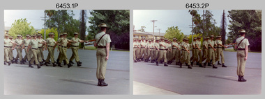 Bendigo Military Museum
Photograph - Officer Commissioning and CO’s Handover Parade, Army Survey Regiment, Fortuna Villa, Bendigo, 1992
This is a set of 28 photographs taken at a CO’s Parade at the Army Survey Regiment, Fortuna, Bendigo in 1992. On this parade WO1 Bill Jones received his commission and by promotion to Captain from CO LTCOL Rene van den Tol. Command of the unit was handed over to LTCOL Rob McHenry. It is probable the commissioning and handover ceremonies occurred on the CO’s Parade. LTCOL Rene van den Tol was CO from 1989 to 1992 and LTCOL Rob McHenry was CO from 1992 to 1993.This is a set of 28 photographs taken at a CO’s Parade at the Army Survey Regiment, Fortuna, Bendigo in 1992. The colour photographs are on 35mm negative film and scanned at 96 dpi. They are part of the Army Survey Regiment’s Collection. .1) - Photo, colour, 1992. Headquarters Squadron marches past RSM WO1 Graham Ragless. .2) - Photo, colour, 1992. Cartographic Squadron marches past RSM WO1 Graham Ragless. L to R: unidentified personnel, WO2 Steve Hansen, CPL Roger Pearson, WO1 Gary Warnest, SSGT Dennis Learmonth, SSGT Greg Else, CPL Ian Bowes, SGT Stuart Symonds. .3) - Photo, colour, 1992. Lithographic Squadron marches past RSM WO1 Graham Ragless. L to R: unidentified personnel, WO1 Steve Egan, LCPL John Bragg, unidentified personnel, WO2 Rob Bogumil, unidentified personnel, SPR Corey Hill. .4) - Photo, colour, 1992. Air Survey Squadron marches past RSM WO1 Graham Ragless. L to R: unidentified personnel, WO1 Allan Hancox, SSGT Wolfgang Thun, unidentified personnel, WO2 Neil ‘Ned’ Kelly, unidentified personnel, SGT Dave Longbottom, SGT Brian Johnson. .5) - Photo, colour, 1992. Cartographic Squadron. L to R: unidentified personnel, SGT Stuart Symonds, CPL Col McInnes, CAPT Mary Anne Martinek in foreground, SPR Jodi Seith, unidentified personnel, SPR Avril (Bray) Lloyd. .6) - Photo, colour, 1992. Air Survey Squadron. L to R: unidentified officer, SSGT Bruce Hammond, SPR Tracy Tillman, SPR Rachel (Stanford) Scott, SPR Paula (Golding) Brinsmead, SGT Graeme Reany, unidentified officer in foreground, unidentified personnel, CPL Steve Coulson. .7) - Photo, colour, 1992. Cartographic Squadron inspection. L to R: RSM WO1 Graham Ragless, unidentified, OC MAJ Graeme Wastell, CO LTCOL Rene van den Tol, unidentified personnel, CPL Col McInnes, SPR Jodi Seith, SPR Avril (Bray) Lloyd. CPL Steve Ellis, SPR Ian Brown, SPR Andrew Lazdovskis. .8) - Photo, colour, 1992. Cartographic Squadron inspection. L to R: OC MAJ Graeme Wastell, CO LTCOL Rene van den Tol, SPR Avril (Bray) Lloyd, CPL Steve Ellis, SPR Ian Brown, SPR Andrew Lazdovskis, SPR Adrian Taylor, unidentified, SPR Mick Knight, SPR Dawn Hoadley, CPL Craig Kellet. .8) to .12) - Photo, colour, 1992. Officer Commissioning Ceremony. L to R: CO LTCOL Rene van den Tol, WO1 Bill Jones promoted to Captain. .13) - Photo, colour, 1992. Officer Commissioning Ceremony. L to R: ADJT CAPT Geoff Ford, RSM WO1 Graham Ragless, CO LTCOL Rene van den Tol, WO1 Bill Jones promoted to Captain. .14) - Photo, colour, 1992. Officer Commissioning Ceremony. WO1 Bill Jones promoted to Captain. .15) - Photo, colour, 1992. Commanding Officer Handover. CO LTCOL Rene van den Tol delivers speech. .16) to .17) - Photo, colour, 1992. Commanding Officer Handover. R to L: CO LTCOL Rene van den Tol hands over to incoming CO LTCOL Rob McHenry. .18) - Photo, colour, 1992. Commanding Officer Handover. L to R: RSM WO1 Graham Ragless, ADJT CAPT Geoff Ford, CO LTCOL Rob McHenry. .19) - Photo, colour, 1992. Commanding Officer Handover. L to R: ADJT CAPT Geoff Ford, RSM WO1 Graham Ragless, CO LTCOL Rob McHenry. .20) - Photo, colour, 1992. Cartographic Squadron marches off parade ground. L to R: OC MAJ Graeme Wastell, unidentified officer, CAPT Greg Oaten, LT Matt Jackson, CAPT Mary Anne Martinek, SPR Mick Knight. .21) & .22) - Photo, colour, 1992. Cartographic Squadron marches off parade ground. .23) - Photo, colour, 1992. Lithographic Squadron marches off parade ground. L to R: OC Bob Coote, unidentified officer, SPR Scott Cameron, unidentified officer, SSGT Russ Mollenhauer, SGT Brian Fauth. .24) - Photo, colour, 1992. Lithographic Squadron marches off parade ground. L to R: LCPL Janet Murray, unidentified, SPR Mick Muzeen, Allison (Ottaway) Wooldrage, SGT Keith Quinton, SGT Frank Lenane, SGT Laurie Justin, SGT Dale Hudson, LCPL John Bragg, unidentified, SGT Kim Reynolds, SPR Corey Hill, SPR Andrew Arman, SPR Ross Anza, WO1 Peter Coombes. .25) - Photo, colour, 1992. Parade guests. L to R: unidentified guests, MAJ Peter Jensen. .26) - Photo, colour, 1992. Parade guests. L to R: unidentified guests, CAPT Doug Arman, unidentified guests. .27) - Photo, colour, 1992. Parade personnel march off. L to R: unidentified, WO2 Ted Burgess, WO1 Ken Slater. .28) - Photo, colour, 1992. Parade personnel. L to R: unidentified, SPR Allan Blake..1P to .28P – There are no annotations.royal australian survey corps, rasvy, army survey regiment, army svy regt, fortuna, asr -
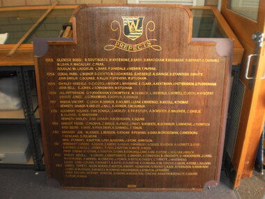 Wangaratta High School
WHS Prefects Honour Board, 1953-1963
Dark brown honour board with gold text shaped like a rectangle with a protrusion at the top to accommodate for a large WHS logo and a PREFECTS heading.PREFECTS 1953 GLENEISE ROSS: B. SOUTHGATE,W. KNEEBONE, D. BARR, B. BRADSHAW, F. BRISBANE, R. BRYANT, E. CANING, M. LEAN, R. MACAULAY, C. PARK. DOUGLAS McLAUGHLIN: L. BARR, P. DINSDALE, J. HERRIN, T. PAPPAS 1954 CORAL PARK: J. BISHOP, D. CIRUTO, M. COCHNEAS, S. HERBLE, A. SAVAGE, D. STANDISH, D. WHITE. JOHN EMSLIE: C. BOURKE, D. ELLIS, P. STEVENS, W. STUDHAM 1955 SHIRLEY HEBERLE: D. CIRCITO, J. BISHOP, L. BRISBANE, E. CLARK, A. KENTMANN, J. PETTERSON, G. TUDDENHAM. JOHN BELL: E. JONES, J. SONNEMANN, W. STUDHAM 1956 JILL PETTERSON: G. TUDDENHAM, V. CROWTHER, M. DERRICK, L. HEBERLE, L. HOWELL, C. LEIGH, M. VINCENT. ERNEST JONES: J. SONNEMANN, B. HOPPER, K. SAVAGE 1957 MARION VINCENT: C. LEIGH, M. DERRICK, R. HOLMES, I. LEAN, E. MARENGO, B. NICOLL, N. THOMAS. KENNETH SAVAGE: K. HADLEY, J. HALL, K. JOHNSON, D. McDONAGH 1958 ROSEMARY HOLMES: P. McDONALD, J. MORELY, B. PRIESTLY, A. BOWFITCH, E. MAUGHER, C. EMSLIE, B. GLOVER, S. BRADSHAW. KENNETH HADLEY: D. McDONAGH, N. ROSENGREN, R. SQUIRE 1959 MARGOT FISHER: C. PROBYN, C. EMSLIE, N. JONES, J. PRATT, W. ROBERTS, M. SCAMBLER, L. SIMMONS, J. THOMPSON. ROSS SQUIRE: A. BARR, B. PENDLEBURY, K. SCAMMELL, T. TONURI 1960 BARBARA JOB: N. JONES, L. BENSON, S. EDGAR, R. FERRARI, H. GIBB, M. GROSSMAN, C. KNEEBONE, F. NEWLAND, D. POLMEAR. NEIL STEWART: B. SUTTON, L. FRY, M, KNEENAN, J. STONE, G. WATSON 1961 MARGARET DUNDAS: S, EDGAR, E. AMERY, R. ANGUS, D. BRADBURY, V. CROSS, S. EVERTON, W. GERRETT, D. GIBB, E. MORRISS, S. NICHOLL, J. POWELL, R. REID, J. SUTTON, M. WHITE, R. WOOD. FRANK COBHAM: M. KEENAN, G. DUSTIN, D. FLINN, R. GROWLING, L. LANG,B. RAE, R. STONE, L. SULLIVAN, J. WELCH 1962 SHIRLEY NICOLL: V. CROSS, J. ADAMTHWAITE, C. BADGER, H. CAMERON, B. CROCKETT, C. HENDERSON, J. LANG, N. KINIBURGH, H. MORRIS, M. OSMOND, J. POWER, B. REITH, R. TANSLEY, C. TIPPETT, J. WHITEHEAD. LAURIE LANG: D. FLINN, P. BENNETT, R. BOYD, G. DUNSTEN, G. GOWLING, R. McCONCHIE, C. SQUIRE, R. STONE, L. SULLIVAN 1963 CHERYL TIPPETT: HELEN MORRIS, R. BENTON, R. BERRY, H. CAMERON, H. CROCKETT, R. EDE, R. FERGUSON, N. KINIBURGH, J. LANG, M. McKENZIE, B. MUNCEY, M. OSMAND, V. ROSEGREN, E. STANTON, J. STEWART. LANCE SULLIVAN: GEOFFREY7 DUSTIN, B. HANSEN, M. IRVINE, R. McCONCHIE, N. MARTIN, W. SCHULTZ, C. SQUIRE, C. STONE, R. SWAN -
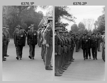 Bendigo Military Museum
Photograph - Army Survey Regiment – Corps Day Parade and Defence Force Service Medal Presentations, Fortuna Villa, Bendigo, 1987
This set of 18 photographs were taken at a Corps Day Parade held at the Army Survey Regiment, Bendigo in July 1987. The Parade Commander was CO LTCOL Don Swiney MBE, and the Reviewing Officer was the Colonel Commandant (honorary appointment) of the Survey Corps - COL Clem Sargent (Retd). The Corps Day Parade was held to commemorate the 72nd anniversary of the formation of the Royal Australian Survey Corps. These photos comprise inspections of the Regiment’s four squadrons, presentations of the Defence Force Service Medal in recognition of 15 years of efficient remunerated service to SSGT Phil Meagher and SGT Wayne Rothwell; and formal group photos of each of the four Squadrons, Officers, and Warrant Officers/Sergeants. See Item 6375.36P for additional photographs taken at the start of the Corps Day Parade, drill movements of the four Squadrons forming up on the parade ground and the formal arrival of the Reviewing Officer.This is a set of 18 photographs of a Corps Day Parade held at the Army Survey Regiment, Fortuna, Bendigo in July 1987. The black & white photographs are on 35mm negative film and are part of the Army Survey Regiment’s Collection. The photographs were scanned at 96 dpi. .1) - Photo, black & white, July 1987. Headquarters Squadron inspection. L to R: unidentified (x3), COL COMDT COL Clem Sargent, CO LTCOL Don Swiney MBE (obscured), OC MAJ Roger Rix. .2) - Photo, black & white, July 1987. Lithographic Squadron inspection. L to R: unidentified, CPL Brian Paul, CPL Gary Tremain, CPL Warren ‘Waldo’ Shirley, unidentified, CPL Stuart Ridge, SSGT Rob Bogumil, SSGT Steve Egan. CPL Roy Hicks, unidentified, COL COMDT COL Clem Sargent, CO LTCOL Don Swiney MBE, OC MAJ Mick Byrne, remainder unidentified. .3) - Photo, black & white, July 1987. Air Survey Squadron inspection. L to R: OC Daryl Hockings CSM, COL COMDT COL Clem Sargent, CO LTCOL Don Swiney MBE, SGT Graham Johnson, unidentified (x4), SGT Lyn Johnson, CPL Steve Rundle, SGT Wayne Rothwell, SGT Bruce Hammond, SGT Barrie Craymer, SPR Brett Parkin .4) - Photo, black & white, July 1987. Cartographic Squadron inspection. L to R: OC MAJ Bob McHenry, COL COMDT COL Clem Sargent, CO LTCOL Don Swiney MBE, CPL Rod Skidmore, SSGT Phil Meagher, SPR Craig Kellet, unidentified, CPL Col McInnes, SPR Nick Cowan, unidentified, CPL Jeff Le-Fevre, SPR Richard Arman, CPL Dan Cirsky, SPR Tom Bloxham, CPL Peter Johnson, unidentified. .5) - Photo, black & white, July 1987. Presentation of Defence Force Service Medal. L to R: WO2 Andy Wilson, COL COMDT COL Clem Sargent, MAJ Terry Edwards, SSGT Phil Meagher, CAPT John South (background). .6) - Photo, black & white, July 1987. Presentation of Defence Force Service Medal. L to R: COL COMDT COL Clem Sargent, SGT Wayne Rothwell, SSGT Phil Meagher, MAJ Roger Rix (background). .7) - Photo, black & white, July 1987. Corp Day Parade guests. L to R: MAJ Duncan Burns, SPR Dianne (Thomas) Soutar, unidentified guests, CPL Kevin ‘Chuck’ Berry, CPL Graeme Priestley, unidentified guests. .8) - Photo, black & white, July 1987. Corp Day Parade guests. L to R: unidentified guests, George Austen, SPR Dianne (Thomas) Soutar, Bob Mason, unidentified guests, CPL Graeme Priestley, unidentified guests, SGT Terry Danger, unidentified guests, CO LTCOL Don Swiney MBE (facing away), COL COMDT COL Clem Sargent. .9) & .10) - Photo, black & white, July 1987. L to R: unidentified guest, COL COMDT COL Clem Sargent, CO LTCOL Don Swiney MBE. .11) - Photo, black & white, July 1987. L to R: unidentified guests, 2IC MAJ Terry Edwards, ADJT CAPT Andrew McLeod. .12) - Photo, black & white, July 1987. WO1 Bob ‘Stretch’ Hayden. .13) - Photo, black & white, July 1987. Lithographic Squadron. Back Row L to R: CPL Paul Baker, CPL Greg Rowe, CPL Kerron South, CPL Stuart Ridge, SPR Rob Jones, CPL Laurie Justin, unidentified, SPR Geoff Webb, unidentified (x2) SPR Shona Hastie, SPR Trevor King, LCPL John Bateman, CPL Ken Peters, CPL Roy Hicks. Middle Row L to R: CPL Brian Paul, unidentified (x2), CPL Jim Ash, CPL Dale Hudson, CPL Gary Tremain, unidentified, LCPL Daryl South, CPL Graham Hales, SPR Bob Bousfield, CPL John ‘Flash’ Anderson, CPL Peter Dillon, CPL Peter Swandale, SPR Colin Yeats, CPL Lance Strudwick. Front Row L to R: CPL Warren ‘Waldo’ Shirley, SGT Gary Kerr, SGT Brian Fauth, SGT Graham Johnston, SSGT Steve Egan, WO2 Bill Jones, OC MAJ Mick Byrne, WO2 Ralph Chant, SSGT Rob Bogumil, unidentified UK exchange, SGT Alan Virtue, SGT Jeff Willey. .14) - Photo, black & white, July 1987. Headquarters Squadron. Back Row L to R: CPL Bob Thrower, PTE Mark Twiss, unidentified (x3), LCPL Bob Sheppard, unidentified, SGT Ian Belmont, SPR Peter Coles, SPR Tracy (Parker) Ash, CPL Steve McGuinness, SGT Bob Garritty, unidentified officer. Middle Row L to R: WO1 Doug Arman, WO2 Kevin Macquire, W01 Noel ‘Nesty’ Coulthard, WO1 Allan Adsett, WO2 Andy Wilson, CPL David Jobe, SGT Kevin Boehm, unidentified (x3), SSGT Greg Gilbert, WO2 George Graham, WO2 Dave Miles, WO2 Ted Burgess, WO1 Ken Slater. Front Row L to R: WO1 Bob ‘Stretch’ Hayden, CAPT Peter ‘Blue’ Blaskett, CAPT Bob Williams, ADJT CAPT Andrew McLeod, 2IC MAJ Terry Edwards, Acting RSM WO1 Dave Thompson, CO LTCOL Don Swiney MBE, OC MAJ Roger Rix, WO2 Alan Bunn, MAJ Duncan Burns, CAPT John South, LT Vicky Thompson, WO1 Peter Warwick. .15) - Photo, black & white, July 1987. Air Survey Squadron. Back Row L to R: SGT Lyn Johnson, CPL John ‘Toad’ Smith, SGT Roger Rees, SGT Wayne Rothwell, CPL Roger Pearson, SPR Leah (Hoffman) Peppler, unidentified, SPR Christine Gordon, SPR Jodi Bowman, SGT Paul Leskovec CSM, SPR Tony Jackson, CPL John Reid, unidentified, SPR Avril (Bray) Lloyd? SPR Diane (Thomas) Soutar, SSGT Brian Collings. Middle Row L to R: unidentified, SGT John ‘Stormy’ Tempest, CPL Perry Burt, SPR Rick Millar, CPL Graeme Priestley, SGT Bruce Hammond, CPL Max Watson, SPR Brett Parkin, SPR Peter Ball, CPL Dick Warsing, SPR Sue (Foote) Bourne, SPR Sandy Wynn, CPL Steve Hill OAM CSM, CPL Steve Rundle, CPL Andy Mallon, SPR Stafford Lester, SPR Steve Moss, CPL Rod Burton. Front Row L to R: SGT Ken Talbot-Smith, SSGT Phil Boyle, SSGT Max Coletti, WO2 Peter Tangey, LT Brian Sloan, WO1 Stevo Hinic, OC Maj Daryl Hockings CSM, CAPT Laurie Newton, WO1 Denis Marshall, SSGT Neil ‘Ned’ Kelly, SSGT Dennis McCarthy, SSGT Adrian ‘Charlie’ Creedy, SGT Barry Craymer, SSGT John ‘Shep’ Shephard. .16) - Photo, black & white, July 1987. Cartographic Squadron. Back Row L to R: unidentified, SPR Michelle Griffith, unidentified, SPR Raelene Munting, unidentified, SPR Ailsa (Sorby) Miller, SPR Kasey Northausen, CPL Lorraine (Daly) Talbot-Smith, SGT John Bettridge, SPR Richard Arman, CPL Colin McInnes, CPL Mick ‘Buddha’ Ellis, SPR Mark Donnelly, CPL Steve Coulson, LCPL Rick Millar, CPL Jeff Le-Fevre. 3rd Row L to R: CPL Paul Trent, unidentified, CPL Brian Johnson, CPL Peter Johnson, CPL Rod Skidmore, SPR Chad Hardwick, LCPL John Lane, LCPL Ken Dempster, unidentified CPL Dan Cirsky, SPR Ross Collishaw, SPR Craig Kellet, CPL Greg Sulman, SPR Tom Bloxham, SPR Ben Lucas. 2nd Row L to R: SPR Jim Humphrey, CPL Pat Drury-Lane, SPR Max Shaw, SPR Barry Hogan, unidentified, CPL David Murphy, SPR Ian Hill, SPR Bruce Graham, CPL Greg Honan, SPR Nick Cowan, CPL Steve Throssel, SPR Ben Tarasenko. Front Row L to R: SGT Eddy Jacobs, SGT Phil Smalley, SGT Rick Van der Bom, SSGT Phil Meagher, SSGT Allan Brown, WO1 Colin Cuskelly, WO2 Pat Lumsden, OC MAJ Bob McHenry, unidentified officer, WO2 Neville Stone, SSGT Ian ‘Rock’ Thistleton, SGT Martin Evans, SGT Terry Danger, SGT Bob Bright. .17) - Photo, black & white, July 1987. Sergeants Mess. Back Row L to R: SGT Graham Johnston, SGT Brian Fauth, SGT Gary Kerr, SGT Alan Virtue, SSGT Rob Bogumil, SSGT Brian Collings, SGT Roger Rees, SGT Phil Smalley, SGT Rick Van der Bom, SGT Martin Evans, SGT Bob Garritty, SSGT Phil Boyle, SGT John ‘Stormy’ Tempest, SSGT Allan Brown, SSGT Max Coletti, SSGT Neil ‘Ned’ Kelly, SSGT Dennis McCarthy. 3rd Row L to R: SGT Bruce Hammond, SGT Wayne Rothwell, SGT Eddy Jacobs, unidentified UK exchange, SSGT Steve Egan, SGT Bob Bright, SSGT Ian ‘Rock’ Thistleton, SGT Paul Leskovec CSM, SGT Barry Craymer, SSGT Greg Gilbert, SGT Kevin Boehm, Terry Danger, SGT Ken Talbot-Smith, WO2 Ted Burgess. 2nd Row L to R: WO2 Ralph Chant, WO2 Andy Wilson, WO2 Bill Jones, WO2 Alan Bunn, SGT John Bettridge, SSGT Adrian ‘Charlie’ Creedy, SGT Lyn Johnson, SSGT Phil Meagher, SSGT John ‘Shep’ Shephard, WO2 Kevin Macquire, WO2 Peter Tangey, WO2 Dave Miles, WO2 George Graham, WO2 Pat Lumsden, SGT Ian Belmont. Front Row L to R: WO1 Colin Cuskelly, Acting RSM WO1 Dave Thompson, WO1 Denis Marshall, 2IC MAJ Terry Edwards, WO1 Peter Warwick, CO LTCOL Don Swiney MBE, WO2 Neville Stone, WO1 Bob ‘Stretch’ Hayden, , W01 Noel ‘Nesty’ Coulthard, WO1 Stevo Hinic, WO1 Ken Slater, WO1 Allan Adsett. .18) - Photo, black & white, July 1987. Officers Mess. Back Row L to R: CAPT Laurie Newton, LT Brian Sloan, unidentified officer, CAPT John South, CAPT Peter ‘Blue’ Blaskett, CAPT Bob Williams, LT Vicky Thompson, unidentified officer, CAPT Andrew McLeod. Front Row L to R: MAJ Daryl Hockings CSM, MAJ Mick Byrne, MAJ Bob McHenry, COL COMDT COL Clem Sargent, CO LTCOL Don Swiney MBE, MAJ Terry Edwards, MAJ Roger Rix, MAJ Duncan Burns. .1P to .18P – There are no personnel identified.royal australian survey corps, rasvy, army survey regiment, army svy regt, fortuna, asr -
 Eltham District Historical Society Inc
Film - Video (VHS), Diamond Creek Fire Brigade, c.1955-1987
Combination of three movie films. Movie One (1950s): 00:00 – 13:14 Black and white footage of Diamond Creek firemen practising in Diamond Street in the 1950s for forthcoming demonstrations of abilities. Mentions of Gordon Brandy and Joe Hislop Running out hoses from old hose reels along Diamond Street, Diamond Creek Displays from various brigades running out and connecting hoses. Also scenes from the 1950s of Diamond Creek Fire Brigade competing in various locations around Victoria and Tasmania. Mentions of Brigade members Dave Kidd, Bruce Hackett, Ron Kirkbride, Jack Marks, Graham Upton who are prominent in these events. Members of Kyneton Fire Brigade also present. Members competing in running out hose reels, connecting hoses togethers and to hydrants then climbing towers to direct water from hose or at a target hanging above the road. Diamond Creek members identified wearing a diamond on their chest and back. Includes scenes of Scottish pipe bands at the events and significant crowds of spectators. Footage of Mel Stone and Beryl Marks, Stan Redpath and Ron Kirkbride, then Ron Kirkbride and Eric Holt viewing flower displays. Film changes to colour at Diamond Creek oval for practice with fire engine entering oval. Members depicted include Bill May, Jack Sinclair, Jim Cox, Bob Beale, Dave Kidd, Bruce Hackett and Captain Clarrie Stone. Reverts to black and white in the 1950s where the Brigade joins forces with the Diamond Valley Community Hospital for a Gala Day on the Diamond Creek Oval. Changes to colour again, possibly same event and scenes of children on bikes and scooters or with prams and carts racing around the oval. Mention of young lad Brian Laurie who has his own fire truck. Dart throwing, pony rides. Scenes with Dr Don Cordner, Gus Lyons, Vic Cohn (?) and spinning wheel and Diamond Creek School children entertain a large crowd with Maypole dancing. Movie Two (1950s): 13:25 – 19:00 This black and white film was taken by a TV film crew in the 1950s depicts a typical call out for the Diamond Creek Fire Brigade. In this case the careless action of a member of the public throwing a lighted match from a car, which can cause extensive damage. Footage features the Shire of Eltham War Memorial tower at Kangaroo Ground before it was modified with a fire spotter’s cabin. Discusses fire spotting operations from the tower. Shows a fire spotter walking around the top of the tower. A fire is detected, and the information is relayed to the nearest fire station, in this case, Diamond Creek. The telephone call is received, and the alarm sounded. Captain Clarrie Stone and firemen May and Shaw leave their workplaces and prepare for action. Scenes of running across the Main Hurstbridge road showing the shops (Shell service station and Chemist prominent). Scenes entering the fire station which has a pictorial warning covering the entire door “Only you can prevent forest fires – If you’re careless – we’re homeless!” Eric Holt pinpoints the location of the fire while Captain Clarrie Stone and Fireman Shaw take note. The advance vehicle (an FE Holden ute, rego GTE-696) leaves to assess the extent of the fire. Having assessed the fire, Fireman Shaw communicates with base showing radio with call sign VL3JZ. Eric Holt takes the call. In the meantime, Captain Clarrie Stone and Fireman Shaw undertake some limited action to address the fire. Firemen Bill May, Jim Bates and Hugh Bar (?) man the tanker. A photo portrait of Queen Elizabeth is visible hanging on the wall. They are later joined by Firemen Jim Cox, Eric DeBuse (?) and Jack Marks. The tanker is seen departing the station and diverging off before the bridge. Captain Clarrie Stone and Fireman Shaw are seen pumping water on the flames with hand pumps when the tanker arrives. The hose is unreeled, and water turned on the flames. Jack Sinclair joins the action. Jim Cox directs water to the high stuff. The fire put out, Jack Marks and Eric DeBuse wind in the hoses and the team head back to town. It’s peaceful again at the memorial tower. Movie Three (1969-1987): 19:14 – 34:34 Colour film “Fired with Dedication”, Country Fire Authority Victoria, produced by I.L. Wadeson, Commentary by A.M. Hem. Credits with CFA Victoria emblem and then placed over a view of an old-style ladder engine. Opens with the scene of a fire engine outside the Diamond Creek Fire Station then various trophies reflecting the competition success of the brigade in various track and disciplined events. Two trophies shown of particular pride to the brigade were for first place in the Torchlight Procession at the State Championships in Mildura in 1986 and also at Swan Hill in 1981. Still photo scenes of ex Captain Clarrie Stone, Brigade Captain for 21 years; ex Captain Jack Marks, 10 years; ex Captain Ian Douglas, 10 years. Cuts to scene of radio control room, January 1969, and news of a fire on the northern side of the township of Diamond Creek. With scenes of flames in bush, the narration explains that until the early 1960s the area was an orchard district which protected the town against the savagery of bushfires. But due to competition from other areas more suitable for orcharding and easier transport to Melbourne the district could no longer remain competitive, and orchards were replaced by grassed areas, which together with the bush areas were a feeding ground for fire. On 8th January 1969, high temperatures and strong north winds, were, with the carelessness of some individual all that was necessary to produce the worst fire the district had seen. Cuts to scene of blackened fields and cattle - Hundreds of hectares of grass land were blackened, and cattle had to be transported to other areas for agistment. Scene of destroyed buildings in the township – 13 houses and the public hall in the town were destroyed as was the theatre equipment which was owned by the fire brigade. The Church of England Hall and bell tower were badly damaged. The whole town could have been burnt out but for the determination, skill, and courage of the Diamond Creek Fire Brigade. Scenes of all that was left of the home on the hill on the west side of the Church of England. Also, the remains of the old Pisy (?) home on the top of the same hill near Lambert Street, and the ruined Crocker home. Cuts to a scene in the mid-1970s to mid-1980s of a house fire in Haley Street attended by the Diamond Creek Fire Brigade. Although the house was severely damaged, it was saved. Mentions that whilst assistance is appreciated, in some circumstances, those doing so are not properly dressed for fighting fires. Breathing apparatus is a must in structure fire attack. Next scene (either on Mangarook or Coventry oval) showing off four Diamond Creek Fire Brigade efficient and very expensive firefighting units. Features a forward control vehicle Toyota 4WD used for conveying task force personnel to the required areas; a Hino Model 3.2 tanker, diesel powered and carries 3,000 litres of water and has a 16 HP petrol driven pump which delivers 900 litres of water per minute; an International tanker (registration TCM-418) which carries 3,000 litres of water with pumping capacity of 600 litres per minute. The Ford diesel powered pumper (registration MXE-754) is a well-equipped vehicle with a water capacity of 1,000 litres and capable of pumping 1,900 litres of water per minute from the main pump, has many lockers which hose equipment such as breathing apparatus and various types of hose nozzles and foam making equipment. The vehicle carries 360m of 64mm diameter hose which can be laid out from the rear lockers and a portable lighting plant, an Oxy Viva resuscitator to revive smoke inhalation victims and forcible entry tools to gain access to structure fires. Views of the main pump and control panel on the vehicle. As well as the main pump, the vehicle is equipped with an auxiliary pump which allows the facility to pump whilst moving. Fire fighters must undergo constant training and hone their skills, Scenes of a training exercise using the pumper to pump from static water. First, the short lengths of suction hose are coupled, a strainer fitted to ensure debris does not foul the pump. Gauges must be constantly monitored to ensure manageable water pressures are maintained. Pressures are normally controlled to allow two fire fighters to work at each nozzle outlet. Two nozzles are tested, one adjustable jet fog type which is used on flammable gasses or within a structure fire to absorb heat. A straight jet nozzle to project water long distances to protect exposed surfaces close to a fire radiated heat. The pumper is quite a versatile vehicle in handling structure fires, but it also carries specialist equipment needed in containing hazardous chemical incidents. Cuts to scene of parade – the Diamond Creek Fire Brigade has with other neighbouring brigades participated in most town fairs and earns the respect of the watching public. It can be seen why this brigade has been so successful at disciplined contests. Views of Plenty Fire Brigade Road Rescue unit which is equipped with the “Jaws of Life” Scenes of athletic competitions – many neighbouring brigades indulge in friendly but keen competition at the Diamond Creek Town Fair. The young are also encouraged to participate in all aspects of Junior Fire Brigade activities and become tomorrow’s generation of volunteer fire fighters. Scene of the 1986 Diamond Creek Town Fair which was the last time veteran Captain Clarrie Stone BEM marched with the brigade. Clarrie was awarded the British Empire Medal for his service to the Country Fire Authority. Also, scenes of vehicles in the parade. Cuts to scene of brigade members in drill formation for inspection by Acting Chief Harry Rothsay (?) on the occasion of the opening of the new fire station extensions on August 29, 1987. Rudy Libel (?) Captain at the time. Scenes of crowds including many dignitaries of neighbouring brigades present including Lieutenant Gordon Grandy (who came down from Queensland for the occasion) and ex-Secretary David Kidd and wife Betty, also ex Captain Clarrie Stone and Mrs Nel Stone, a life member of the Ladies Auxiliary, the Reverend Jock Ryan, son of J.L Ryan, founder of the Diamond Creek Fire Brigade, Foundation Captain of the fire brigade, Keith Bradbury and Mrs Bradbury. Pauline Dick accepts a community service award for services to the CFA. Recognising over 47 and a half years of service, a presentation is made by Mr Neil Marshall, Acting Chairman of the CFA to ex Captain Clarrie Stone with response by Clarrie. Other members of the official party include Cr. Martin Wright, Shire President Wayne Phillips and local Member of Parliament, Mrs Pauline Toner. Ex foreman John Bennett is presented with a life member’s awards by Captain Rudy Libel. The camera also catches Gwen Cox, Jean Ryan and Bessie Layton (?) Provides historic footage of people, places and equipment and a record of the worst fires expoerienced in Diamond Creek in 1969BASF Standard Quality SQ E-180 VHS dubbing (poor quality) of three films Converted to MP4 file format 0:34:38, 1.85GBOn label: "Donation - August 2000 Diamond Creek Unit Old films made up from Fire Brigade shows at competitions - also Kangaroo Ground Tower being used"video recording, diamond creek fire brigade, 1986 diamond creek town fair, a.m. hem, acting chief harry rothsay, athletic competitions, beryl marks, bessie layton, betty kidd, bill may, bob beale, brian laurie, bruce hackett, captain clarrie stone, chemist, church of england hall, clarrie stone, clarrie stone bem, country fire authority victoria, coventry oval, cr. martin wright, crocker home, dart throwing, dave kidd, david kidd, diamond creek, diamond creek fire station, diamond creek oval, diamond creek school, diamond creek town fair, diamond street, diamond valley community hospital, dr don cordner, eric debuse, eric holt, fe holden ute, fire damage – buildings, fire spotter, fire spotter’s cabin, fire station extension, fired with dedication (film), firefighting units, fireman shaw, firemen jim cox, ford pumper, foundation captain, gala day, gordon brandy, gordon grandy, graham upton, gus lyons, gwen cox, haley street, hino model 3.2 tanker, house fire, i.l. wadeson, ian douglas, international tanker, j.l ryan, jack marks, jack sinclair, january 1969, jaws of life, jean ryan, jim bates and hugh bar, jim cox, joe hislop, john bennett, kangaroo ground, kangaroo ground tower, keith bradbury, kyneton fire brigade, lambert street, main hurstbridge road, mangarook oval, maypole dancing, mel stone, mildura 1986, mrs bradbury, mxe754 vic registration, neil marshall, nel stone, orchard district, oxy viva resuscitator, pauline dick, pauline toner mp, pisy home, plenty fire brigade road rescue unit, pony rides, radio control room, reverend jock ryan, ron kirkbride, rudy libel, shell service station, shire of eltham war memorial, shire president wayne phillips, spinning wheel, stan redpath, state championships, swan hill 1981, tcm418 vic registration, torchlight procession, toyota 4wd, trophies, vic cohn, victorian bushfires - 1969, vl3jz -
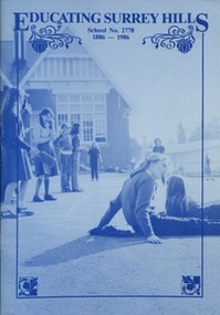 Surrey Hills Historical Society Collection
Book, Educating Surrey Hills - School No 2778, 1886-1986, 1986
Donation made on behalf of Surrey Hills Primary School. A second lesser copy was donated at a much earlier date.A 59 page informal history of Surrey Hills State School, No 2778. To quote the authors: "we have not used footnotes, nor a bibliography; and we have used reminiscence without always ensuring that facts and dates are strictly accurate." The book is richly illustrated with photos, excerpts of student work and other ephemera. It is not indexed. Headings are: Beginnings, The Cadet Corps, Head Teacher Bennett, School Days 1900-1925, War Time & Beyond, The Mothers' Club, Childhood Illness, School Days in '30s, Expansion, PWD Problems, Depression and Wartime, Post War Crowding, memories, Mr Wheeler, Migrants, Royal Tours, Pedestrian Crossings, The Canteen, Craft Room, Sports Days, Acquisition of Mr Prior's House, Parents Right to Know, Social Service, School Committee, Concerts & Balls, Mothers' Club to Parents' Club, Library, More PWD Problems, Changes, Camps, Recent Principals. This copy includes a copy of the Centenary Weekend Programme which has been stuck inside the front cover.wekworth, - (miss), reardon, edith, lauchlan, thelma, grant, mavis, higgins, nancy, kellan, coster, joyce, parker, marjorie, dyson, joy, sutton, phyllis, cadmar, gwennyth, mclaughlin, maurine, wendorf, winifred, broadbent, doreen, hawes, hilda, powell, crocker, beatrix, triggs, dorothy, peers, ker, pryde, norma, clemson, kathleen, owen, doris, glasscock, elaine, lovering, w b (mr), dyer, e a (mr), gamble, william, brown, j k (mr), raw, whitfield t, doyle, annie, st stephens presbyterian church, cadets, bennett, george t, brigadier general gordon, cottingham, r v (mr), day, george, greaves, arthur, servan, alice, renkin, anne, lutheran peace memorial home, gourlay, education, schools, doney, - (mr), collins, fyfe, alexander, fire brigades, maypoles, duck, lorraine, hendy, ives, alfred, reaburn, john, walduck, gwyneth, world war, 1914-1918, breeden, horace, horrie, wise, amy (miss), blogg, john kendrick, newington, lily (miss), parents clubs, brookes, - (mrs), lancashire, deans, johnson, herbert, -(mrs), travancore, jamieson, welch, mcdonald, harley, mclean, jack, rex theatre, surrey hills progress association, gamer, ernest, southall, ivan, influenza, barbara, ross, poliomyelitis, scott, moroney, daniel, thwaites, jean, constable, oswell, frank, large, gifford, a e (rev), gillies, j (rev), buxton, porter, jill, morgan, jan, 1939-1945, williamson, joan, cargill, jackson, van ernst, cooke, tyrell's milkbar, plaw, graeme, dairies, chenu, a h, rutzou, peter, bowie, heymann, megan, wilson, ritter, alan, martyn, dawson, l (mrs), mcgregor, d (mrs), e (mrs), fiedler, wheeler, lewis, marsh, rhyll, slater, games, gangell, pam, barrow, ford, henry, mcewan, marion, conlon, kathy, canterbury recreation reserve, surrey park, chatham oval, mooney, neil, kitson, surrey dive, monk, kay, saldineri, macqueen, lyndy, thomson, daley, susan, discombe, diane, hanson, robert, mulvey, albers, angela, tucker, david, glover, bright, lynette, mcinnes, jeanette, nethercott, turnball, eric, smith, roberts, chasemore, lyle, chislett, miss, capon program, k n (mr), fuller, i d (mr), henwood, j w (mr), g (mr), veitch, g (mrs), m (mrs), cheetham, j (mr), gardner, l (mr), d (mr), sepitka, lorna, balfe, win, wells, bob, keith, ian, kett, mr, elizabeth, liney, bruce, macarthur, rob, kelly, paula, neil b, sydenham, shirley, dixon, o'hagan, ros, van someren, fred, norman, burns, roberta, harry, christine, barker, henry j t, nutt, ernest h, richards, benjamin, lievesley, john h, knight, gabriel, clough, john s, hepburn, james, tinney, arthur h, blanchen, bernard j, somerwell, elizabeth j, john t, john m, caldicott, howard t -
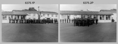 Bendigo Military Museum
Photograph - Army Survey Regiment – Corps Day Parade and Defence Force Service Medal Presentations, Fortuna Villa, Bendigo, 1987
This set of 36 photographs were taken at a Corps Day Parade held at the Army Survey Regiment, Bendigo on the 1st of July 1987. The Parade Commander was CO LTCOL Don Swiney MBE, and the Reviewing Officer was the Colonel Commandant (honorary appointment) of the Survey Corps - COL Clem Sargent (Retd). The Corps Day Parade was held to commemorate the 72nd anniversary of the formation of the Royal Australian Survey Corps. It was an occasion for great celebration at the Regiment. After 45 years in Bendigo, its future was finally secure. At the traditional anniversary parade, the Colonel Commandant COL Clem Sargent praised the efforts of the Regiment and led the soldiers in three cheers for the record production of the previous 12 months. More information is provided in page 140 of Valerie Lovejoy’s book 'Mapmakers of Fortuna – A history of the Army Survey Regiment’ ISBN: 0-646-42120-4. This set of photos cover the start of the Corps Day Parade, drill movements of the four Squadrons forming up on the parade ground and the formal arrival of the Reviewing Officer. See Item 6376.18P for additional photographs taken at the Corps Day Parade, comprising inspections of the Regiment’s four squadrons, presentations of the Defence Force Service Medal in recognition of 15 years of efficient remunerated service to SSGT Phil Meagher and SGT Wayne Rothwell; and formal group photos of each of the four Squadrons, Officers, and Warrant Officers/Sergeants.This is a set of 36 photographs of a Corps Day Parade held at the Army Survey Regiment, Fortuna, Bendigo in July 1987. The black & white photographs are on 35mm negative film and are part of the Army Survey Regiment’s Collection. The photographs were scanned at 96 dpi. .1) - Photo, black & white, July 1987. Unidentified personnel marching onto parade ground. .2) - Photo, black & white, July 1987. Squadrons marching on parade ground. 1st rank L to R: LCPL Ken Dempster, unidentified (x2), WO2 Neville Stone, remainder unidentified. .3) - Photo, black & white, July 1987. Right file L to R: WO2 George Graham, WO2 Dave Miles, remainder unidentified. .4) - Photo, black & white, July 1987. L to R: WO1 Stevo Hinic, 1st rank – unidentified, CPL Max Watson, unidentified, WO2 Peter Tangey. .5) - Photo, black & white, July 1987. L to R: WO2 Ralph Chant, CPL Gary Drummond, SGT Gary Kerr, unidentified, CPL Dale Hudson, unidentified, LCPL Daryl South, CPL Kerron South, CPL Peter Dillon, SGT Brian Fauth, SGT Graham Johnston, CPL Peter Swandale, CPL Jim Ash, unidentified, CPL Gary Tremain, unidentified, unidentified UK exchange, unidentified WO1 Ken Slater, WO1 Doug Arman. .6) - Photo, black & white, July 1987. L to R: WO2 Alan Bunn, CPL Bob Thrower, SGT Kevin Boehm, CPL Peter Coles, CPL John ‘JJ’ Smith, CPL Laurie Justin, LCPL Bob Sheppard, CPL Steve McGuiness, SGT Bob Garritty, SPR Jim Humphrey, unidentified (x2), SSGT Greg Gilbert, unidentified, WO2 George Graham. .7) - Photo, black & white, July 1987. L to R: CPL Rod Skidmore, SSGT Phil Meagher, WO1 Colin Cuskelly, unidentified, CPL Colin McInnes, unidentified, CPL Jeff Le Fe-Fevre, SPR Richard Arman, CPL Dan Cirsky, CPL Michelle Griffith, LCPL Tom Bloxham, SPR Ailsa (Sorby) Miller, CPL Peter Johnson, unidentified, LCPL Ken Dempster, unidentified (x2), WO2 Neville Stone. .8) - Photo, black & white, July 1987. L to R: CPL Bob Thrower, unidentified (x2), SGT Kevin Boehm, CPL Peter Coles, SGT John ‘Stormy’ Tempest, CPL John ‘JJ’ Smith, unidentified CPL Laurie Justin, unidentified, WO2 Alan Bunn, unidentified (x2), LCPL Bob Sheppard, unidentified, CPL Steve McGuiness, unidentified, SGT Bob Garritty, unidentified, SPR Jim Humphrey. .9) - Photo, black & white, July 1987. Foreground – Acting RSM WO1 Dave Thompson, background L to R: MAJ Daryl Hockings CSM, CAPT Bob Williams, CAPT Laurie Newton, ADJT CAPT Andrew McLoud, MAJ Bob McHenry, CAPT Peter ‘Blue’ Blaskett, MAJ Mick Byrne, MAJ Roger Rix. .10) - Photo, black & white, July 1987. Officers ready to take posts. Background L to R: MAJ Daryl Hockings CSM, CAPT Bob Williams, CAPT Laurie Newton, ADJT CAPT Andrew McLoud, MAJ Bob McHenry, CAPT Peter ‘Blue’ Blaskett, MAJ Mick Byrne, MAJ Roger Rix, LT Vicky Thompson, Foreground – 2IC MAJ Terry Edwards, Acting RSM WO1 Dave Thompson, WO2 Alan Bunn, CPL Bob Thrower, SGT Kevin Boehm, CPL Peter Coles, CPL John ‘JJ’ Smith, CPL Laurie Justin, LCPL Bob Sheppard. .11) to .13) - Photo, black & white, July 1987. Officers ready to take posts. L to R: MAJ Daryl Hockings CSM, CAPT Bob Williams, CAPT Laurie Newton, ADJT CAPT Andrew McLoud, MAJ Bob McHenry, CAPT Peter ‘Blue’ Blaskett, MAJ Mick Byrne, MAJ Roger Rix, LT Vicky Thompson, CAPT John South. .14) - Photo, black & white, July 1987. L to R: WO2 Alan Bunn, MAJ Roger Rix. .15) - Photo, black & white, July 1987. L to R: unidentified personnel, CAPT Laurie Newton, unidentified, CAPT Bob William, MAJ Mick Byrne, WO2 Dave Miles. .16) &.17) - Photo, black & white, July 1987. L to R: 2IC MAJ Terry Edwards handing Parade over to CO LTCOL Don Swiney MBE. .18) - Photo, black & white, July 1987. Arrival of Reviewing Officer- COL COMDT COL Clem Sargent. Saluted by CPL Kevin ‘Chuck’ Berry. .19) - Photo, black & white, July 1987. Arrival of Reviewing Officer- COL COMDT COL Clem Sargent. Saluted by CPL Kevin ‘Chuck’ Berry. MAJ Duncan Burns on right departing vehicle. .20) - Photo, black & white, July 1987, Reviewing Officer - COL COMDT COL Clem Sargent returning salute from CO LTCOL Don Swiney MBE. .21) - Photo, black & white, July 1987, Headquarters Squadron approaching the Dias. L to R: CAPT John South, unidentified, MAJ Roger Rix, unidentified, SPR Tracy (Parker) Ash, unidentified, T Vicky Thompson, CPL Bob Thrower, SGT Kevin Boehm, CPL Peter Coles, CPL John ‘JJ’ Smith, CPL Laurie Justin, LCPL Bob Sheppard, remainder partially obscured, CO LTCOL Don Swiney MBE, COL COMDT COL Clem Sargent. .22) - Photo, black & white, July 1987, Headquarters Squadron’s MAJ Roger Rix salutes the Reviewing Officer. L to R: CAPT John South, MAJ Roger Rix, unidentified, SPR Tracy (Parker) Ash, unidentified, Vicky Thompson, CPL Bob Thrower, SGT Kevin Boehm, CPL Peter Coles, CPL John ‘JJ’ Smith, CPL Laurie Justin, LCPL Bob Sheppard, CPL Steve McGuiness, SGT Bob Garritty, SPR Jim Humphrey, WO2 George Graham. .23) - Photo, black & white, July 1987, Headquarters Squadron’s MAJ Roger Rix salutes the Reviewing Officer. L to R: CAPT John South, MAJ Roger Rix, unidentified, SPR Tracy (Parker) Ash, unidentified, Vicky Thompson, CPL Bob Thrower, SGT Kevin Boehm, CPL Peter Coles, CPL John ‘JJ’ Smith, CPL Laurie Justin, LCPL Bob Sheppard, CPL Steve McGuiness, SGT Bob Garritty, SPR Jim Humphrey, WO2 George Graham, CO LTCOL Don Swiney MBE, COL COMDT COL Clem Sargent, .24) - Photo, black & white, July 1987, Headquarters Squadron continues past the Dias. L to R: unidentified (x3), Vicky Thompson, unidentified, CPL Bob Thrower, SGT Kevin Boehm, CPL Peter Coles, CPL John ‘JJ’ Smith, CPL Laurie Justin, LCPL Bob Sheppard, CPL Steve McGuiness, SGT Bob Garritty, SPR Jim Humphrey, WO2 George Graham. .25) - Photo, black & white, July 1987, Army Survey Regiment senior officers and Air Survey Squadron approaching the Dias. L to R: 2IC MAJ Terry Edwards, ADJT CAPT Andrew McLeod, OC MAJ Daryl Hockings CSM, acting RSM WO1 Dave Thompson, centre file marker CPL Max Watson, right marker CPL Perry Burt, CAPT Bob Williams, remainder unidentified, CO LTCOL Don Swiney MBE, COL COMDT COL Clem Sargent. .26) - Photo, black & white, July 1987, Army Survey Regiment senior officers and Air Survey Squadron salute the Reviewing Officer. L to R: 2IC MAJ Terry Edwards, ADJT CAPT Andrew McLeod, OC MAJ Daryl Hockings CSM, acting RSM WO1 Dave Thompson, centre file marker CPL Max Watson, right marker CPL Perry Burt, CAPT Bob Williams, remainder unidentified, CO LTCOL Don Swiney MBE, COL COMDT COL Clem Sargent. .27) - Photo, black & white, July 1987, Army Survey Regiment senior officers and Air Survey Squadron salute the Reviewing Officer. L to R: 2IC MAJ Terry Edwards, ADJT CAPT Andrew McLeod, unidentified, OC MAJ Daryl Hockings CSM, acting RSM WO1 Dave Thompson, unidentified, SGT Barrie Craymer, CAPT Bob Williams, centre file marker CPL Max Watson, right marker CPL Perry Burt, remainder unidentified, CO LTCOL Don Swiney MBE, COL COMDT COL Clem Sargent. .28) - Photo, black & white, July 1987, Air Survey Squadron salutes the Reviewing Officer. L to R: CPL Steve Hill OAM CSM, unidentified, SSGT Neil ‘Ned’ Kelly, WO2 Peter Tangey, WO1 Dennis Marshall. Followed by Lithographic Squadron L to R: SGT Graham Johnston, SGT Bryan Fauth, CPL Jim Ash, CPL Peter Swandale, CPL Roy Hicks, remainder unidentified. .29) - Photo, black & white, July 1987, Lithographic Squadron’s MAJ Mick Byrne salutes the Reviewing Officer. L to R: WO1 Dennis Marshall (Air Svy Sqn), SGT Graham Johnston, SGT Bryan Fauth, MAJ Mick Byrne, CPL Jim Ash, CPL Peter Swandale, unidentified (x2), CPL Lance Strudwick, CPL John ‘Flash’ Anderson, SGT Alan Virtue, CPL Greg Rowe, unidentified (x2), CPL Graham Hales, unidentified, CPL Paul Baker, SPR Colin Yeats, unidentified, WO1 Ken Slater, WO1 Doug Arman. .30) to .31) - Photo, black & white, July 1987, Lithographic Squadron’s MAJ Mick Byrne salutes the Reviewing Officer. L to R: SGT Graham Johnston, SGT Bryan Fauth, MAJ Mick Byrne, CPL Jim Ash, CPL Peter Swandale, unidentified (x2), CPL Lance Strudwick, CPL John ‘Flash’ Anderson, SGT Alan Virtue, CPL Greg Rowe, unidentified (x2), CPL Graham Hales, unidentified, CPL Paul Baker, SPR Colin Yeats, unidentified, WO1 Ken Slater, WO1 Doug Arman. .32) to .35) - Photo, black & white, July 1987, Cartographic Squadron’s MAJ Bob McHenry salutes the Reviewing Officer. L to R: MAJ Bob McHenry, CAPT Peter ‘Blue Blaskett, left file L to R: SPR Ross Collishaw, SPR Ben Lucas, centre file L to R: SGT Martin Evans, SSGT Ian ‘Rock’ Thistleton, SGT Eddy Jacobs, right file L to R: CPL Rod Skidmore, SSGT Phil Meagher, SPR Craig Kellet, unidentified, CPL Col McInnes, SPR Nick Cowan, unidentified, CPL Jeff Le-Fevre, SPR Richard Arman, CPL Dan Cirsky, SPR Tom Bloxham, CPL Peter Johnson, unidentified, LCPL Kenne Dempster. .36) - Photo, black & white, July 1987, Reviewing Officer - COL COMDT COL Clem Sargent returns salute..1P to .36P – There are no personnel identified.royal australian survey corps, rasvy, army survey regiment, army svy regt, fortuna, asr -
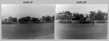 Bendigo Military Museum
Photograph - Army Survey Regiment Freedom of Entry Parade, Queen Elizabeth Oval, Bendigo, 1980
The Freedom of Entry to the City was an honour conferred by the Bendigo City Council to the Army Survey Regiment in 1970. 1980 was the third time the unit exercised its freedom of marching into the city with swords drawn, bayonets fixed and drums beating. The honour is usually bestowed upon local regiments, in recognition of their dedicated service, and it is common for military units to periodically exercise their freedom by arranging a parade through the city. Led by the Regiment’s CO – LTCOL Bob Skitch, the unit marched down View St in the CBD, along Pall Mall and up Gaol Rd to the Queen Elizabeth II Oval. The ceremonial parade followed with a march past the guests of honour, Mayor of Bendigo Councillor Paul Tomkinson and military dignitaries. The parade concluded after formal inspections of the troops. The Regiment also exercised its Freedom of Entry with anniversary parades in 1977, 1980, 1985, 1990 and 1995. Some photos in this set were also printed on photo paper and catalogued under item 6021.25P. Photos of the march are catalogued under item 6491.21P. Photos of the Freedom of Entry parade rehearsal are catalogued under item 6479.38P.These black and white photographs of the Army Survey Regiment were taken on the occasion of the Freedom of Entry parade to the City of Bendigo in 1980. The photographs are on 35mm negative film and scanned at 96 dpi. They are part of the Army Survey Regiment’s Collection. .1) to .7) - Photo, black & white, 1980. Squadrons formed up at beginning of parade. .8) & .9) - Photo, black & white, 1980. 3rd Military District Band marches to their parade position. .10) to .11) - Photo, black & white, 1980. Squadrons formed up parade with 3rd Military District Band playing music. .12) to .14) - Photo, black & white, 1980. Officers formed up before taking posts. L to R: MAJ Peter Eddy, LT Brendon Jaego-Banks, CAPT Peter Searle - UK Exchange, unidentified, ADJT CAPT John Harrison, MAJ Sam Schwartz US Exchange, unidentified, MAJ Robin Blackburn, remainder unidentified. .15) - Photo, black & white, 1980. Officers march to their posts. L to R: MAJ Peter Eddy, LT Brendon Jaego-Banks, CAPT Peter Searle - UK Exchange, unidentified, ADJT CAPT John Harrison, MAJ Sam Schwartz US Exchange, unidentified, MAJ Robin Blackburn, remainder unidentified. .16 - Photo, black & white, 1980. Officers march to their posts. .17 - Photo, black & white, 1980. Army Svy Regt awaits the arrival of the Mayor – Councillor Paul Tomkinson. .18 - Photo, black & white, 1980. CO LTCOL Bob Skitch escorts the Mayor – Councillor Paul Tomkinson and unidentified guest to the dais. .19) to .25) – Army Svy Regt salutes the Mayor – Councillor Paul Tomkinson. .26) - Photo, black & white, 1980. CO LTCOL Bob Skitch escorts the Mayor – Councillor Paul Tomkinson to Headquarters Squadron to inspect its personnel. .27) - Photo, black & white, 1980. Headquarters Squadron inspection. L to R: OC MAJ Paddy Strunks, RSM WO1 Aub Harvey, Mayor – Councillor Paul Tomkinson, SPR Chris ‘Charlie’ Brown, unidentified, SGT John Grove (orderly room), unidentified, SPR Jeff Ruiz, WO2 Max Neil, unidentified, SGT Alan Brown, SGT Tim Allanson. .28) - Photo, black & white, 1980. Headquarters Squadron inspection. L to R: OC MAJ Paddy Strunks, Mayor – Councillor Paul Tomkinson, unidentified, SGT Rick Warren, unidentified, CPL Andy Wilson, WO2 Ted Burgess. .29) - Photo, black & white, 1980. Headquarters Squadron inspection. L to R: OC MAJ Paddy Strunks, RSM WO1 Aub Harvey, unidentified civilian, Mayor – Councillor Paul Tomkinson, unidentified, SGT Rick Warren, unidentified, CPL Andy Wilson, WO2 Ted Burgess. .30) - Photo, black & white, 1980. Cartographic Squadron’s OC CAPT Bob Roche salutes the Mayor – Councillor Paul Tomkinson. L to R: unidentified civilian, CO LTCOL Bob Skitch. In background L to R: SSGT Bob Scaddan, unidentified, CPL John Tempest, CAPT Simon Lemon, SSGT Colin Cuskelly, CPL Trevor Bottomley, SPR Bob Sheppard, WO2 Bob ‘Stretch’ Hayden, unidentified, CPL Ian McKenzie, FLTLT Ron Aitken, SPR Ian Fitzgerald, SPR Greg Else. .31) - Photo, black & white, 1980. Cartographic Squadron’s OC CAPT Bob Roche salutes the Mayor – Councillor Paul Tomkinson. L to R: unidentified civilian, CO LTCOL Bob Skitch. In background L to R: CPL Terry Danger, SPR Rod Skidmore, SSGT Bob Scaddan, unidentified, CPL John Tempest, CAPT Simon Lemon, SSGT Colin Cuskelly, CPL Trevor Bottomley, SPR Bob Sheppard, WO2 Bob ‘Stretch’ Hayden, unidentified, CPL Ian McKenzie, FLTLT Ron Aitken, SPR Ian Fitzgerald, SPR Greg Else. .32) - Photo, black & white, 1980. Cartographic Squadron inspection. L to R: OC CAPT Bob Roche, Mayor – Councillor Paul Tomkinson. In background L to R: SGT Stu Thaxter, unidentified, SSGT John Barrie, CPL Roger Pearson, SGT Doug Carswell, SPR Peter Main, WO2 Bob ‘Stretch’ Hayden. .33) - Photo, black & white, 1980. Cartographic Squadron inspection. L to R: CO LTCOL Bob Skitch, OC CAPT Bob Roche, unidentified civilian, SGT Doug Carswell, Mayor – Councillor Paul Tomkinson, WO2 Bob ‘Stretch’ Hayden. .34) - Photo, black & white, 1980. Female Contigent inspection L to R: unidentified, SPR Gae (Amato) Robinson, SPR Scheryl Delforce, unidentified officer, unidentified civilian, Mayor – Councillor Paul Tomkinson, CPL Marrianne (Van De Zee) De Groot, SPR Cathy Regan, SPR Ginny (Turner) Rowe, SPR Ilen Isaac, SPR Penny Knott, SPR Santina (Argetto) Straube, SPR Gina (Coore) Neilson, WO2 Pat Lumsden. .35) - Photo, black & white, 1980. Female Contigent inspection L to R: SPR Scheryl Delforce, unidentified officer, CO LTCOL Bob Skitch, unidentified civilian, Mayor – Councillor Paul Tomkinson, SPR Ginny Turner, SPR Ilen Isaac, SPR Penny Knott, SPR Santina (Argetto) Straube, SPR Gina (Coore) Neilson, WO2 Pat Lumsden. .36) - Photo, black & white, 1980. Female Contigent inspection L to R: SPR Scheryl Delforce, unidentified officer, CO LTCOL Bob Skitch, unidentified civilian, Mayor – Councillor Paul Tomkinson, SPR Cathy Regan, SPR Ginny Turner, SPR Ilen Isaac, SPR Penny Knott, SPR Santina (Argetto) Straube, SPR Gina (Coore) Neilson, WO2 Pat Lumsden. .37) - Photo, black & white, 1980. Female Contigent inspection L to R: SPR Scheryl Delforce, unidentified officer, CO LTCOL Bob Skitch, CPL Marrianne (Van De Zee) De Groot, unidentified civilian, Mayor – Councillor Paul Tomkinson, SPR Ilen Isaac, SPR Penny Knott, SPR Santina (Argetto) Straube, SPR Gina (Coore) Neilson, WO2 Pat Lumsden. .38) - Photo, black & white, 1980. Air Survey Squadron’s OC MAJ Peter Eddy salutes the Mayor – Councillor Paul Tomkinson. L to R: unidentified civilian, CO LTCOL Bob Skitch. In background L to R: WO1 Jim ‘Triple J’ Jefferies, SPR Allan Choat, SPR Geoff Havelberg, CPL Alan Hawkins, CPL Dave Cook, LT Brendon Jaego-Banks, SGT Jim Beard, SSGT Russell ‘Rusty’ Williams, SGT Cam Chapman, SSGT Alan Derby, SSGT Greg Buckingham. .39) - Photo, black & white, 1980. Air Survey Squadron inspection. L to R: back of CAPT Kym Weston, OC MAJ Peter Eddy, Mayor – Councillor Paul Tomkinson, unidentified civilian. .40) - Photo, black & white, 1980. Air Survey Squadron inspection. L to R: CAPT Peter Searle - UK Exchange, unidentified officer, unidentified civilian, Mayor – Councillor Paul Tomkinson, unidentified, SSGT Alan Derby, LCPL Paul Hopes, SPR Peter Jones, SPR John Lane, WO2 Brian Meade, CPL Mick Hogan, CPL Greg Byers, SGT Cliff Webb. .41) - Photo, black & white, 1980. Air Survey Squadron inspection. Centre rank L to R: SGT Bruce ‘Stretch’ Gordon, WO2 Chris Parkinson. Rear rank L to R: SPR Allan Choat, unidentified, SPR Jamie McRae, SSGT Russell ‘Rusty’ Williams, SSGT Greg Buckingham, CPL Greg Byers, CPL Roger Rees, SPR Gary Ames, SGT Greg Gilbert, SSGT Peter Warwick, WO2 Mick Dempster. .42) - Photo, black & white, 1980. Air Survey Squadron inspection. Rear rank: SSGT Russell ‘Rusty’ Williams. Centre rank L to R: SPR Geoff Havelberg, CPL Peter Treble, SGT Jim Beard, SPR Peter Hardy, SPR Steve Hilton, SPR John Lane, CPL Mick Hogan, Mayor – Councillor Paul Tomkinson, OC MAJ Peter Eddy. .43) - Photo, black & white, 1980. Air Survey Squadron inspection. Centre rank L to R: SGT Bruce ‘Stretch’ Gordon, WO2 Chris Parkinson. Mayor – Councillor Paul Tomkinson, OC MAJ Peter Eddy. Rear rank L to R: SPR Allan Choat, unidentified, SPR Jamie McRae, SSGT Russell ‘Rusty’ Williams, SSGT Greg Buckingham, CPL Greg Byers, CPL Roger Rees, SPR Gary Ames, SGT Greg Gilbert, SSGT Peter Warwick, WO2 Mick Dempster. .44) - Photo, black & white, 1980. Lithographic Squadron’s OC MAJ Robin Blackburn salutes the Mayor – Councillor Paul Tomkinson. L to R: unidentified civilian, CO LTCOL Bob Skitch. In background L to R: WO1 Manfred Panknin, SSGT Peter Coombes, CPL Frank Lenane, SPR Per Andersen, CPL John ‘Flash’ Anderson, unidentified, MAJ Sam Schwartz US Exchange, CPL Warren ‘Waldo’ Shirley, SPR Warren ‘Wah’ Hall, unidentified, SPR Neville Carr, SPR Paul Davis, SPR Paul Baker, CPL Mick ‘Buddha’ Ellis, SPR Martin Van De Maele, CPL Bill Jones, SPR Greg Rowe. .45) - Photo, black & white, 1980. Lithographic Squadron inspection. L to R: RSM WO1 Aub Harvey, SPR Warren ‘Wah’ Hall, CO LTCOL Bob Skitch, SPR Paul Davis, unidentified civilian, unidentified, OC MAJ Robin Blackburn, CPL Lance Strudwick, Mayor – Councillor Paul Tomkinson, SPR Neville Carr, SPR Roy Hicks, SSGT Trevor Osborne, SPR Paul Baker, CAPT Stan Vote, CPL Bill Jones, SGT Greg Francis-Wright, SGT Ralph Chant, CPL Garry Drummond, WO2 Noel ‘Nesty’ Coulthard. .46) - Photo, black & white, 1980. Lithographic Squadron inspection. Front rank L to R: SGT Greig Kidman, SPR Garry Hudson, SPR Gary Tremain, CPL Steve Egan, SPR Greg Rowe, CPL Mick ‘Buddha’ Ellis, remainder unidentified. Centre rank: SSGT Kevin Macquire. Inspection party L to R: CO LTCOL Bob Skitch, OC MAJ Robin Blackburn, unidentified civilian, Mayor – Councillor Paul Tomkinson. Rear rank L to R: unidentified (x5), CPL Warren ‘Waldo’ Shirley, SPR Neville Carr, SPR Paul Baker, CPL Bill Jones, CPL Garry Drummond, SGT Graeme Jeffers, WO2 Tom Pattison. .47) - Photo, black & white, 1980. Lithographic Squadron inspection. Front rank L to R: SSGT Trevor Osborne, SGT Greig Kidman, SPR Garry Hudson, SPR Gary Tremain, CPL Steve Egan, SPR Greg Rowe, CPL Mick ‘Buddha’ Ellis, remainder unidentified. Centre rank: SSGT Kevin Macquire, SGT Ralph Chant. Inspection party L to R: OC MAJ Robin Blackburn, RSM WO1 Aub Harvey, unidentified civilian, Mayor – Councillor Paul Tomkinson. Rear rank L to R: SPR Paul Baker, CPL Bill Jones, CPL Garry Drummond, SGT Graeme Jeffers, WO2 Tom Pattison. 48) - Photo, black & white, 1980. Lithographic Squadron inspection. Inspection party L to R: OC MAJ Robin Blackburn, Mayor – Councillor Paul Tomkinson, CO LTCOL Bob Skitch, unidentified civilian. Rear rank L to R: WO2 Tom Pattison, SGT Graeme Jeffers, CPL Garry Drummond, CPL Bill Jones, CPL SPR Neville Carr, Warren ‘Waldo’ Shirley, unidentified. Rear supernumery: WO1 John McCulloch. 49) - Photo, black & white, 1980. Lithographic Squadron inspection. Inspection party L to R: OC MAJ Robin Blackburn, CO LTCOL Bob Skitch, Mayor – Councillor Paul Tomkinson, unidentified civilian, RSM WO1 Aub Harvey. Rear rank L to R: WO2 Tom Pattison, SGT Graeme Jeffers, remainer unidentified. 50) - Photo, black & white, 1980. 3rd Military District Band inspection. L to R: unidentified band master, CO LTCOL Bob Skitch, Mayor – Councillor Paul Tomkinson. 51) - Photo, black & white, 1980. CO LTCOL Bob Skitch delivers his speech. 52) & .53) - Photo, black & white, 1980. Army Svy Regt squadrons stand at ease during CO LTCOL Bob Skitch’s speech.There are no personnel identified. royal australian survey corps, rasvy, army survey regiment, army svy regt, fortuna, asr -
 Flagstaff Hill Maritime Museum and Village
Award - Medal, Nelson Johnson, November 1880
This medal for bravery, for rescue of the crew from the shipwreck “Eric the Red” on 4th September 1880, was awarded to one of the crew of the steamer S.S. Dawn by the President of the United States in July 1881. The medal is engraved with the name “Nelson Johnson” (the anglicised version of his Swedish name Neils Frederick Yohnson). It was donated to Flagstaff Hill Maritime Village in 2013 by Nelson’s granddaughter. Nelson had migrated from Sweden to Sydney in 1879. The next year in 1880, aged 24, he was a seaman on the steamship Dawn and involved in the rescue of the survivors of the Eric the Red. Nelson Johnson was a crew member of the S.S. Dawn and was one of the rescue team in the dinghy in the early morning of September 4th 1880. Medals were awarded to the Captain and crew of the S.S. Dawn by the President of the United States, through the Consul-general (Mr Oliver M. Spencer), in July 1881 “ … in recognition of their humane efforts in rescuing the 23 survivors of the American built wooden sailing ship, the Eric the Red, on 4th September 1880.” The men were also presented with substantial monetary rewards and gifts. The city of Warrnambool’s care of the survivors was also mentioned by the President at the presentation, saying that “the city hosted and supported the crew ‘most graciously’. Previously, a week after the shipwreck, the Australian Government had also conveyed its thanks to the Captain and crew of the S.S. Dawn “Captain Griffith Jones, S.S. Dawn, The Hon. Mr Clark desires that the thanks of the Government should be conveyed to you for the prompt, persevering and seamanlike qualities displayed by you, your officers and crew in saving the number of lives you did on the occasion referred to. The hon. The Commissioner has also been pleased to award you a souvenir in commemoration of the occasion, and a sum of 65 pounds to be awarded to your officers and crew according to annexed scale. I am, &c, W Collins Rees, for and in the absence of the Chief Harbour Master.” The Awards are as follows: - Crew of DAWN'S lifeboat-Chief Officer, Mr G. Peat, 15 pounds; boat's crew-G. Sterge, A.B., 5 pounds; T. Hammond, A.B., 5 pounds; J. Black, A.B., 5 pounds; H. Edwards, A.B., 5 pounds. Dinghy's Crew-Second Officer, Mr Christie, 10 pounds; boat's crew -F. Lafer, A.B., 5 pounds; W. Johnstone, A.B., 5 pounds; Mr Lear, provedore, 5 pounds; Mr Dove, purser, 5 pounds. Captain Jones receives a piece of plate. (from “Wreck of the ship Eric the Red” by Jack Loney) The medal’s history, according to the Editor of ‘E-Sylum’ (the newsletter of The Numismatic Bibliomania Society “… appears to be an example of an 1880 State Department medal, catalogued as LS-3 (page 322 of R. W. Julian's book, Medals of the United States Mint: The First Century 1792-1892). The reverse is mostly blank for engraving, surrounded by a thin wreath. It was designed by George Morgan, chief engraver for the Philadelphia Mint, and struck in gold, silver and bronze. The one pictured here (in The Standard newspaper, 2nd July 2013) appears to be silver.” The following is an account of the events which led to the awarding of this medal. The American ship Eric the Red was a wooden, three-masted clipper ship. She had 1,580 tons register and was the largest full-rigged ship built at Bath, Maine, USA in 1871. She was built and registered by Arthur Sewall, later to become the partnership E. & A. Sewall, the 51st ship built by this company. The annually-published List of Merchant Vessels of the U.S. shows Bath was still the home port of Eric the Red in 1880. The vessel was named after the Viking discoverer, Eric ‘the Red-haired’ Thorvaldsson, who was the first European to reach the shores of North America (in 980AD). The ship Eric the Red at first traded in coal between America and Britain, and later traded in guano nitrates from South America. In 1879 she was re-metalled and was in first-class condition. On 10th June 1880 (some records say 12th June) Eric the Red departed New York for Melbourne and then Sydney. She had been commissioned by American trade representatives to carry a special cargo of 500 exhibits (1400 tons) – about a quarter to a third of America’s total exhibits - for the U.S.A. pavilion at Melbourne’s first International Exhibition. The exhibits included furniture, ironmongery, wines, chemicals, dental and surgical instruments, paper, cages, bronze lamp trimmings, axles, stamped ware, astronomical and time globes, samples of corn and the choicest of leaf tobacco. Other general cargo included merchandise such as cases of kerosene and turpentine, brooms, Bristol's Sarsaparilla, Wheeler and Wilson sewing machines, Wheeler’s thresher machine, axe handles and tools, cases of silver plate, toys, pianos and organs, carriages and Yankee notions. The Eric the Red left New York under the command of Captain Zaccheus Allen (or some records say Captain Jacques Allen) and 24 other crew including the owner’s son third mate Ned Sewall. There were also 2 saloon passengers on board. The ship had been sailing for an uneventful 85 days and the voyage was almost at its end. As Eric the Red approached Cape Otway there was a moderate north-west wind and a hazy and overcast atmosphere. On 4th September 1880 at about 1:30 am Captain Allen sighted the Cape Otway light and was keeping the ship 5-6 miles offshore to stay clear of the hazardous Otway Reef. However, he had badly misjudged his position. The ship hit the Otway Reef about 2 miles out to sea, southwest of the Cape Otway light station. Captain Allen ordered the wheel to be put ‘hard up’ thinking that she might float off the reef. The sea knocked the helmsman away from the wheel, broke the wheel ropes and carried away the rudder. The lifeboats were swamped, the mizzenmast fell, with all of its riggings, then the mainmast also fell and the ship broke in two. Some said that the passenger Vaughan, who was travelling for his health and not very strong, was washed overboard and never seen again. The ship started breaking up. The forward house came adrift with three of the crew on it as well as a longboat, which the men succeeded in launching and keeping afloat by continually bailing with their sea boots. The captain, the third mate (the owner’s son) and others clung to the mizzenmast in the sea. Then the owner’s son was washed away off the mast. Within 10 minutes the rest of the ship was in pieces, completely wrecked, with cargo and wreckage floating in the sea. The captain encouraged the second mate to swim with him to the deckhouse where there were other crew but the second mate wouldn’t go with him. Eventually, the Captain made it to the deckhouse and the men pulled him up. At about 4:30 am the group of men on the deckhouse saw the lights of a steamer and called for help. At the same time, they noticed the second mate and the other man had drifted nearby, still on the spur, and pulled them both onto the wreck. The coastal steamer SS Dawn was returning to Warrnambool from Melbourne, and its sailing time was different to its usual schedule. She was built in 1876 and bought by the Portland and Belfast Steam Navigation Co. in 1877. At the time of this journey, she was commanded by Captain Jones and was sailing between Melbourne and Portland via Warrnambool. The provedore the Dawn, Benjamin Lear, heard cries of distress coming through the portholes of the saloon. He gave the alarm and the engines were stopped. Cries could be heard clearly, coming from the land. Captain Jones sent out crew in two boats and fired off rockets and blue lights to illuminate the area. They picked up the three survivors who were in the long boat from Eric the Red. Two men were picked up out of the water, one being the owner’s son who was clinging to floating kerosene boxes. At daylight, the Dawn then rescued the 18 men from the floating portion of the deckhouse, which had drifted about 4 miles from where they’d struck the reef. Shortly after the rescue the deckhouse drifted onto breakers and was thrown onto rocks at Point Franklin, about 2 miles east of Cape Otway. Captain Jones had signalled to Cape Otway lighthouse the number of the Eric the Red and later signalled that there was a wreck at Otway Reef but there was no response from the lighthouse. The captain and crew of the Dawn spent several more hours searching unsuccessfully for more survivors, even going back as far as Apollo Bay. On board the Dawn the exhausted men received care and attention to their needs and wants, including much-needed clothing. Captain Allen was amongst the 23 battered and injured men who were rescued and later taken to Warrnambool for care. Warrnambool’s mayor and town clerk offered them all hospitality, the three badly injured men going to the hospital for care and others to the Olive Branch Hotel, then on to Melbourne. Captain Allen’s leg injury prevented him from going ashore so he and three other men travelled on the Dawn to Portland. They were met by the mayor who also treated them all with great kindness. Captain Allen took the train back to Melbourne then returned to America. Those saved were Captain Zaccheus Allen (or Jacques Allen), J. Darcy chief mate, James F. Lawrence second mate, Ned Sewall third mate and owner’s son, John French the cook, C. Nelson sail maker, Clarence W. New passenger, and able seamen Dickenson, J. Black, Denis White, C. Herbert, C. Thompson, A. Brooks, D. Wilson, J. Ellis, Q. Thompson, C. Newman, W. Paul, J. Davis, M. Horenleng, J. Ogduff, T. W. Drew, R. Richardson. Four men had lost their lives; three of them were crew (Gus Dahlgreen ship’s carpenter, H. Ackman steward, who drowned in his cabin, and George Silver seaman) and one a passenger (J. B. Vaughan). The body of one of them had been found washed up at Cape Otway and was later buried in the lighthouse cemetery; another body was seen on an inaccessible ledge. Twelve months later the second mate James F. Lawrence, from Nova Scotia passed away in the Warrnambool district; an obituary was displayed in the local paper. Neither the ship nor its cargo was insured. The ship was worth about £15,000 and the cargo was reportedly worth £40,000; only about £2,000 worth had been recovered. Cargo and wreckage washed up at Apollo Bay, Peterborough, Port Campbell, Western Port and according to some reports, even as far away as the beaches of New Zealand. The day after the wreck the government steamship Pharos was sent from Queenscliff to clear the shipping lanes of debris that could be a danger to ships. The large midship deckhouse of the ship was found floating in a calm sea near Henty Reef. Items such as an American chair, a ladder and a nest of boxes were all on top of the deckhouse. As it was so large and could cause danger to passing ships, Captain Payne had the deckhouse towed towards the shore just beyond Apollo Bay. Between Apollo Bay and Blanket Bay, the captain and crew of Pharos collected Wheeler and Wilson sewing machines, nests of boxes, bottles of Bristol’s sarsaparilla, pieces of common American chairs, axe handles, a Wheelers’ Patent thresher and a sailor’s trunk with the words “A. James” on the front. A ship’s flag-board bearing the words “Eric the Red” was found on the deckhouse; finally, those on board the Pharos had the name of the wrecked vessel. During this operation, Pharos came across the government steamer Victoria and also a steamer S.S. Otway, both of which were picking up flotsam and wreckage. A whole side of the hull and three large pieces of the other side of the hull, with some of the copper sheathing stripped off, had floated onto Point Franklin. Some of the vessels' yards and portions of her masts were on shore. The pieces of canvas attached to the yards and masts confirmed that the vessel had been under sail. The beach there was piled with debris several feet high. There were many cases of Diamond Oil kerosene, labelled R. W. Cameron and Company, New York. There were also many large planks of red pine, portions of a small white boat and a large, well-used oar. Other items found ashore included sewing machines (some consigned to ‘Long and Co.”) and notions, axe and scythe handles, hay forks, wooden pegs, rolls of wire (some branded “T.S” and Co, Melbourne”), kegs of nails branded “A.T. and Co.” from the factory of A. Field and Son, Taunton, Massachusetts, croquet balls and mallets, buggy fittings, rat traps, perfumery, cutlery and Douay Bibles, clocks, bicycles, chairs, a fly wheel, a cooking stove, timber, boxes, pianos, organs and a ladder. (Wooden clothes pegs drifted in for many years). There seemed to be no personal luggage or clothing. The Pharos encountered a long line, about one and a half miles, of f locating wreckage about 10 miles off land, southeast of Cape Otway, and in some places about 40 feet wide. It seemed that more than half of it was from Eric the Red. The ship’s crew rescued 3 cases that were for the Melbourne Exhibition and other items from amongst the debris. There were also chairs, doors, musical instruments, washing boards, nests of trunks and flycatchers floating in the sea. Most of the goods were saturated and smelt of kerosene. A section of the hull lies buried in the sand at Parker River Beach. An anchor with a chain is embedded in the rocks east of Point Franklin and a second anchor, thought to be from Eric the Red, is on display at the Cape Otway light station. (There is a photograph of a life belt on the verandah of Rivernook Guest House in Princetown with the words “ERIC THE RED / BOSTON”. This is rather a mystery as the ship was registered in Bath, Maine, USA.) Parts of the ship are on display at Bimbi Park Caravan Park and at Apollo Bay Museum. Flagstaff Hill Maritime Village also has part of the helm (steering wheel), a carved wooden sword (said to be the only remaining portion of the ship’s figurehead; further research is currently being carried out), a door, a metal rod, samples of wood and this medal awarded for the rescue of the crew. Much of the wreckage was recovered by the local residents before police and other authorities arrived at the scene. Looters went to great effort to salvage goods, being lowered down the high cliff faces to areas with little or no beach to collect items from the wreckage, their mates above watching out for dangerous waves. A Tasmanian newspaper reports on a court case in Stawell, Victoria, noting a man who was caught 2 months later selling tobacco from the wreckage of Eric the Red. Some of the silverware is still treasured by descendants of Mr Mackenzie who was given these items by officials for his help in securing the cargo. The gifts included silver coffee and teapots, half a dozen silver serviette rings and two sewing machines. A Mr G.W. Black has in his possession a medal and a purse that was awarded to his father, another Dawn crew member who was part of the rescue team. The medal is similarly inscribed and named “To John Black ….” (from “Shipwrecks” by Margaret E. Mackenzie, 3rd edition, published 1964). The wreck and cargo were sold to a Melbourne man who salvaged a quantity of high-quality tobacco and dental and surgical instruments. Timbers from the ship were salvaged and used in the construction of houses and shed around Apollo Bay, including a guest house, Milford House (since burnt down in bushfires), which had furniture, fittings and timber on the dining room floor from the ship. A 39.7-foot-long trading ketch, the Apollo, was also built from its timbers by Mr Burgess in 1883 and subsequently used in Tasmanian waters. It was the first attempt at shipbuilding in Apollo Bay. In 1881 a red light was installed about 300 feet above sea level at the base of the Cape Otway lighthouse to warn ships when they were too close to shore; It would not be visible unless a ship came within 3 miles from it. This has proved to be an effective warning. Nelson Johnson married Elizabeth Howard in 1881 and they had 10 children, the father of the medal’s donor being the youngest. They lived in 13 Tichbourne Place, South Melbourne, Victoria. Nelson died in 1922 in Fitzroy Victoria, age 66. In 1895 the owners of the S.S. Dawn, the Portland and Belfast Steam Navigation Co., wound up and sold out to the Belfast Company who took over the Dawn for one year before selling her to Howard Smith. She was condemned and sunk in Suva in 1928. The State Library of Victoria has a lithograph in its collection depicting the steamer Dawn and the shipwrecked men, titled. "Wreck of the ship Eric the Red, Cape Otway: rescue of the crew by the Dawn". The medal for bravery is associated with the ship the “The Eric the Red which is historically significant as one of Victoria's major 19th century shipwrecks. (Heritage Victoria Eric the Red; HV ID 239) The wreck led to the provision of an additional warning light placed below the Cape Otway lighthouse to alert mariners to the location of Otway Reef. The site is archaeologically significant for its remains of a large and varied cargo and ship's fittings being scattered over a wide area. The site is recreationally and aesthetically significant as it is one of the few sites along this coast where tourists can visit identifiable remains of a large wooden shipwreck, and for its location set against the background of Cape Otway, Bass Strait, and the Cape Otway lighthouse.“ (Victorian Heritage Database Registration Number S239, Official Number 8745 USA) This medal was awarded to Nelson Johnson by the U.S. President for bravery in the rescue of the Eric the Red crew. The obverse of the round, solid silver medal has an inscription around the rim. In the centre of the medal is the head of Liberty to the left, hair in a bun, with a sprig of leaves in the top left of a band around her head. There is a 6-pointed star below the portrait, between the start and end of the inscription. There are two raised areas on the rim, horizontally opposite each other, from the edge to just below the lettering and coinciding with the holes drilled in the edge. Slightly right of the top is a round indentation in the rim. The reverse has a wreath of leaves as a border, joined at the bottom by a ribbon bow. In the centre of the medal is an inscription, decorated with 3-pronged design and dots. The edge is plain with 2 small, rough and uneven holes horizontally opposite to each other, as though they had been used for mounting the medal at some stage. The medal has a matte finish on both sides and is slightly pitted and scratched.“PRESENTED BY THE PRESIDENT OF THE UNITED STATES” around the perimeter of the obverse of the medal. “TO / Nelson Johnson, / seaman of the British, / str “Dawn”, for bravery, / at risk of life, / in / rescuing the crew of / the American Ship / “Eric the Red.” “M” on obverse, truncation of the portraitwarrnambool, flagstaff hill, flagstaff hill maritime village, maritime museum, shipwreck coast, great ocean road, shipwreck artefact, eric the red, zaccheus allen, sewall, 1880, melbourne exhibition, cape otway, otway reef, victorian shipwreck, medal, nelson johnson, neils frederick yohnson, s.s. dawn, george morgan, hero -
 Federation University Historical Collection
Book - Newspaper clippings, Eureka Stockade Newspaper Clippings, 1923-2015
The Eureka Stockade was fought on the Eureka Lead, Ballarat East on 03 December 1854. Keith Rash was a signwriter who learnt his trade at the Ballarat School of Mines. He was very interested in local history and wrote articles for the local newspapers. The clippings on Eureka would have been used to inform his articles, and research on the site of the Eureka Stockade. Ken Clements was former Academic Registrar at Ballarat College of Advanced Education (now University of Ballarat). He was a committee member of the Eureka Stockade Memorial Park Committee for a number of years. Dr Dorothy Wickham has researched Eureka over a number of decades, and has published a number of titles on the topic. Clare Gervasoni has researched Eureka over a number of decades, and has published a number of titles on the topic, including coordination of www.Eurekapedia.org for Ballarat Reform League Inc. Three white A4 folders of newspaper clippings dating from 1923 to 2012. The clippings are in chronological order. The clippings were collected by Keith Rash, and were later supplemented by clippings collected by Ken Clements. Further clippings collected by Dorothy Wickham, mainly around the 1990s were inserted throughout the folders in chronological order, as well as later clippings by Clare Gervasoni .1) Folder One - Eureka Cuttings 1923 - 1984 * Courier 05/05/1923 - Eureka Progress Association (W. Groves, Stockader Phillips of Rocky Lead, Stockader Wilson, G. Lakeland, Eureka Hall.) * Courier 10.08.1931 - Banquet at Eureka - Progress Association's Annual Meeting (McGregor, Parsons, W.J. McAdam, 75th anniversary. Elsworth, Kent, Robert McGregor) *Courier 11/08/1932 - Eureka Reserve - Committee Annual Social. (E. Parsons, C.C. Phillips, D.C. McGrath, T.T. Hollway, Bolster, Mackenzie, Mares, Hendy) * Courier 07/07/1939 - Eureka Improvement Committee, Eureka Reserve * Courier 04/12/1950 - Australian Democracy Was Born at Eureka * Courier 04/09/1951 - Council Seeks Development of Eureka Land - potential housing Commission development on site of Last Chance Mine. (J. Welsh). * Ballarat Courier 12/1952 - Few Remembered Eureka Affair (98th anniversary, A.W. Nicholson, C.E. Brown, L. O'Brien, R. Joshua, Soldiers' Memorial Band) * Courier 07/12/1953 - Few Commemorated the Affair at Eureka - 99th anniversary at the Stockade reserve (F.J. Cutts, L. O'Brien, R. Joshua, Peter Lalor, C.E. Brown. * Courier 14/04/1954 - Eureka Centenary - meeting to determine form of commemoration. * Courier 15/04/1954 - Getting ready - Centenary celebrations (Picture of Diggers Memorial, F.J. Cutts, C. Mott). * Courier 15/04/1954 - Eureka Centenary Planned (F.J. Cutts, Geoffrey Searle, Edgar Bartrop, G. Swenson, B. Parsons, T.E. Carter, M. Collins, Mrs L.M. Quinlan, Grenville, Eureka Progress Association, Arthur Jones, E.J. Crimmins, Bernard D'Arcy, A.W. [Bert] Strange). * Guardian 25/11/1954 - Diary of a Eureka Stockader [signed RDW] (Bentley, Fletcher, McIntyre, Westerby, Ballarat Reform League, monster meeting, Bakery Hill, Charles Hotham) * Argus 04/12/1954 - Eureka Day Marred by Storm (image of Bert O'Toole in Red Coat uniform, Peter Lalor Statue, A.C. Pittard, F.J. Cutts, Bernard D'Arcy, L. Moyle, Catherine Smith, wounded, death, Eureka Celebrations, anniversary, John Cain *Age Literary Supplement, 04/12/1954 - The motives that prompted the tragic Eureka rising . (image of Charles Hotham, government troops attack, Eureka Stockade Monument) 1851 discovery of gold in Victoria, centenary of Eureka Stockade, author MM, Governor Latrobe, law abiding nature of most miners, most miners were British but other nationalities represented, miners former occupations were varied, many did not "strike it rich", by 1853 the earnings of most diggers had fallen very low, 30/- licence fee, digger hunts, cries of "Joe" or "The Traps", 5 pound fine or 6 month imprisonment for not carrying Licence, La Trobe had hired ex-convicts as police, Governor Charles Hotham 1854, Bentlys Hotel, Commissioner Rede, miners leader Peter Lalor, Carboni Raffaello, Press warning by "Age", Ballarat Reform League, November 29 diggers meeting, licences burned, November 30 licence hunt, new flag and Southern Cross oath, the Stockade, revolution ?, Stockade Garrison, December 3 1854, the battle, 125 prisoners, 13 charged with high treason, all prisoners acquitted, Lalor and Vern into hiding, 'democratic revolution' or 'undisguised rebellion' ? , Miner's Right, Chartist ideas involved, Lalor became a member of Victorian parliament, Eureka monument inscription, little revolutionary significance. * The Argus 06/12/1954 - 100th Eureka Day ( [ Images - bearded miners, Bert O'Toole, simulated battle, red coats] battle tableau, Centenary celebrations. Mr Cain Premier, Spirit of Eureka). * Ballarat Courier 22/04/1961 Attack on the Paint ( [Image - Eureka Monument Guns] vandals). * Ballarat Courier 13/09/1962 - Little-Known Aspects of Eureka Affair (E.J. Crimmins and the 109th Eureka Anniversary); Eureka Drilling (Photo of M. Milligan drilling for water for the Eureka Pool) * Ballarat Courier 10/12/1963 - Eureka Relics in Public Display (Trev Negri), Little-known aspects of the Eureka affair (E J Crimmins, 13 State prisoners, Creswick men, M Greville), Eureka Request (Apex explanatory notice). * Ballarat Courier 12/05/1964 - Plaque to tell Eureka Story (Apex donation on monument). * Ballarat Courier 09/06/1964 - Permission is sought (re Eureka Reserve small Hall). * Ballarat Courier 28/08/ 1964 - Eureka should be much better attraction (Mayor Cr Webb, Rotary). * No Chlorination at Stockade Pool 24/08/1964 (A Jones secretary) * Ballarat Courier 10/10/1964 - Assurance given on Eureka Swimming Pool (Murray Byrne MLC, Bill Stephen MLA, pool plans [Images - Photo of Jones, Stephen Byrne - diagram of Eureka reserve swimming pools, caravan park, monument area] ) * Ballarat Courier 23/06/1964 - Pool plans ready for tenders MLA (Black Hill) * Ballarat Courier 26/11/1966 - Eureka: Was that clash in 1854 inevitable ? ([Image - Monument, Peter Lalor statue], by J J Sheehan, foreigners, Chartists, poorly armed. * 03/12/1966 Part 2 - Eureka: No plan by the Diggers to Attack, by j j Sheehan ([Images - Eureka collection, W C Colbourne and G Brookes with old rifle] Corrupt, Instructed, Withers' view, The last hunt, Police spies). * Ballarat Courier 19/12/1968 - Eureka commemoration definite next year,1854 - (Connolly Association, 3 December, 'Finest thing in Australasian history', few attending, L O'Brien, public apathy, A Williams, successful 1954 centenary, W. Roff, Eureka Progress Association) * 23/11/67 - Eureka and Miners' rights (G P Ryan letter, no representation, excessive licence system, offensive administration.brutality, Gov Hotham, barricade on Eureka lead, Miners' Rights replaced Licences but now worthless, mining monopolies, democracy). * Eureka Flag Ceremony (L O'Brien, false report, revive annual Eureka service). * Ballarat Courier 12/05/1867 Questions of Eureka (W Thompson letter, why military names on monument ? Why mount irrelevant cannons on monument ? Where is the flag ?). Lalor's refuge (between Bungaree and Bullarook ?, Fr t Linane ). Building linked with Ballarat (at French end of Collins Street Melbourne, Sir Robert Nickle, relief march to Ballarat, historian E Moorhead, 40th regiment link ). * Ballarat Courier 08/01/1968 - Too little history at Eureka says Visitor (Image - Eureka monument, Mrs L Riley, frequent complaint, B McOrist, proposed Stockade model). * Ballarat Courier c 1968 - Gallery Eureka flag may be the original (Cr W Roff, at Ballarat Art Gallery, fraud ?, matching pieces). * Ballarat Courier 11/04/1968 Pool of reflection ([Image - Eureka pool and willows], near full again). * Ballarat Courier 20/08/1968 - Eureka Reserve (Rotary Clubs' proposed project). *Ballarat Courier 05/10/1968 - Picturesque Willows ([Image- willows in good condition at Eureka Stockade]). * Ballarat Courier, November 1968 - Eureka Ceremony will be Revived (Eureka Progress Association to revive Eureka Commemoration at the site, Connolly Association Australia, J. Garvey, A. Jones) [Photo of L. O'Brien, A, Jones, R.A. Mitchell, Jim Styker and Alan Mills *Ballarat Courier 15/11/1968 - Walkathon for Stockade Diorama (planned life-size Diorama at Stockade depicting the Eureka riot, Rotary Cup walkathon fundraiser. *Ballarat Courier 26/11/1968 - Discussing plans ([Image - Les O'Brien, Arthur Jones, Alan Mills et al], memorial service Sunday). * Ballarat Courier 26/11/1968 - Eureka ceremony will be revived (four year lapse, Connolly Association, Eureka Progress Association) * Ballarat Courier 02/12/1968 - 500 attend Eureka ceremony (114th commemoration, on island in Lake, Mayor Cr M J Brown, speaker Mr Dudley Erwin MLA, significance to Australia, Connolly Association morning ceremony, Bernie Nolan, W Hartley). * Courier 1969 - Letters to the editor - Peter Lalor's Grave, Losing Places of Beauty loss of verandahs, Eureka Stockade Caravan Park, Eureka Swimming Pool), Ireland's Dilemma (Catholic Church), Small Group in "Affair" (F.R. Muller) * Courier 22/04/1969 - $7000 grant for Eureka Diorama (Sir Henry Bolte approves grant, $2 for $1, Rotary walkathon basis, City Council interest, Diorama details, information about Eureka for public, Eureka Park Sovereign Hill and Montrose cottage combination). * Courier 21/08/1969 - Mayor turns sod at Diorama site ([Image- Mayor Cr M J Brown et al], life size representation of stockade scene, Mr W F Stephen MLA). * Courier 06/12/1969 - The 'affair at Eureka' ([Image- Diorama] Few remembered anniversary of bid for democratic Government in 1850s, Mayor Cr Alec Mills, Murray Byrne, Colonial secretary J Foster resignation, reforms, hostility, unpopular, end of era). * Courier mixed 1969 - City link with Eureka Stockade threatened, - Eureka signposts [Diggers Memorial, Soldiers Memorial], - Eureka Anniversary - Souvenir of Eureka (William Cowland's pistol). * Courier :/05/1970 - Fascinated ([Image- children at near completed Diorama]). * Courier 10/08/1970 - Mayor opens Eureka Diorama ([Image- Diorama scene of 3 December 1854 battle], Mayor Cr A E Mills, Rotarians, Eric Pearce voice tape recording). * Courier 08/08/1970 - Eureka Diorama should be Popular-Rotarian ([Image- Diorama shed], City's new drawcard, Diorama Opening para and advert). * Courier 12/09/1970 - The Quick change Eureka Stockade ([Image- Eureka Stockade Hotel], was Australia Felix Hotel, Mr Kevin Worthington). * Courier 22/09/1970 - Missing golden opportunities (message unheeded, American tourists misled, bewildered tourists). * Courier 20/10/1970 - Ballarat's monument to vandalism ? (Ballarat, Wendouree and South Rotary clubs' pride: Eureka Diorama, joy and heartaches, vandalism damage, thoughtless and vicious). * Courier 20/10/1970 - Marked for demolition ([Image- Ballarat east railyard] troops path to Eureka stockade). * Courier 20/10/1970 - Diorama sound system target for vandals ([Image- Jack Redman removing foreign material from diorama starting mechanism). * Courier 03/11/1970 - Record Good but Facts are Wrong ([Image- depiction of Eureka scene], article by Paul Hughes, RCA LP record based on musical play re Eureka Stockade, errors) * Courier 11/03/1970 - Diorama for Eureka Stockade ([Images- view of park, view of diorama]). * Courier 4/12/1970 - Anniversary of Eureka uprising ([Images- Southern Cross flag over Montrose cottage, R Fenton and V Demedeze], 107th anniversary, Scouts Eureka re-enactment, Diggers didn't mind delay). * Courier 16/04/1971 - Lake disappearing ([Image- Lake Elsworth being filled], Olympic standard pool planned for same site). * Courier 31/07/1971 - Birthplace of Peter Lalor ([Image- 211 year old Lalor home in Ireland], Eureka Stockade (park) name change to Eureka Stockade Memorial Park (in Sept. 1972). * Courier 01/02/1971 Eureka Stockade Gardens - ([Images- Gardens near Caretakers Cottage, Miss J Hetherington and begonias in Eureka Stockade hothouse). * Courier 11/1971 - Eureka Grant (for toilet block in Eureka Caravan Park), Ancestor Died in Stockade Battle (William Clifton), $93,887 Tender for Eureka Pool) * Courier 10/12/1971 - Eureka FILM 'iMMORAL' ( Erwin's attack, DUDLEY ERWIN MP, suggested cuts). * Courier 21/02/1972 - It is not a subsidy (says Stockade Director, re film, Added bonus, also Descendant upset- letter from Peter A Lalor re film content). * Ballarat Courier 31/10/1973 - Eureka Stockade a National Shrine, (Editorial , Minister Grassby's support) - Eureka 'Shrine of our History', (Grassby's pledge). * Ballarat Courier 14/02/1973, - $1000 Grant for Eureka Flag (from State government to Ballarat Art Gallery, Bill Stephen MLA, Murray Byrne Minister for Tourism). * Ballarat Courier 26/05/1973, - Eureka Flag Restored (by Val D'Angri, Peter Lalor details, [Images- Val at work on flag, painting of 1854 Ballarat]). * Ballarat Courier 26/10/1973 - Taking another look at Eureka (Editorial, historical and social significance of Eureka Stockade, Neighbour attractions, Thinking BIG), and Editorial report, Put up the Stockade again - and a Monorail ? * Ballarat Courier 31/10/1973 - Eureka Stockade a National Shrine (Minister's support) * Ballarat Courier October 1973 - Eureka a 'Shrine of our History' (Grassby's pledge, Alex Barnett's plans for Eureka Stockade ). * Ballarat Courier 03/11/1973, - Build Eureka into a tourist drawcard ,(Challenge to Clubs. W H McGregor; Ceremony, Tram Link, the "Iceberg"). * Ballarat Courier 08/11/1973, - Grassby to get Eureka Plans - (from Alex Barnett). * Ballarat Courier 29/11/1973, - Memorial Plans with Town Hall (Architect plans also sent to Mr Grassby). * Ballarat Courier 13/11/1973, - Prime Minister will unveil Eureka Flag [Image - Erecting Flag frame at Ballarat Art gallery, Val D'Angri]. * Ballarat Courier 14/11/1973, - What plan for the Eureka memorial ? (Public entitled to know, National concept) and (Eureka Upgrading). * Ballarat Courier 24/11/1973, - Connolly Opposition to Eureka Proposals (Association protests about limited support for commemoration of Eureka) and (Gallery search for Lalor descendant). *Ballarat Courier 24/11/1973, - The Affair at Eureka (Part one by J J Sheehan) [Images -Jones' Circus tent, and Stockade location, also Peter Lalor photo, also artist's impression of the 13 men on trial]. Part 2 )3/11/1973 (Eureka Diorama) * Ballarat Courier 01/12/1973, - Grassby to see Eureka Plan on Site [Image- Architect's sketch of proposed $450,000 Museum building]. *Ballarat Courier 01/12/1973, - The Affair at Eureka (The fight for justice, concluding J J Sheehan series), [Images - painting of fight, and the supposed site of the Stockade]. * Ballarat Courier 02/12/1973, Victorian Treasures at Art Gallery (Eureka Flag and "Moonrise exhibition), [Image - J Nicholson cleaning 'Peter Lalor' portrait]. * Ballarat Courier 03/12/1973, - The Events Which led up to Eureka (Licence contentions,the perceived need for fortification around the workings at the Eureka lead, the death of James Scobie, the burning of Bentley's Hotel, the conviction of three miners on 20 November, arrival of armed soldiers at the Camp. Also Raffaello observations, and advert for public viewing of Eureka Flag. [Image - Diggers and Soldiers names on Eureka Monument]. * Ballarat Courier 03/12/1973, - The past celebrated but what of the future ? (119th anniversary of the Eureka Stockade uprising, but current politicians are under close scrutiny) * Ballarat Courier 03/12/1973, - Teacher-Politician is behind Eureka story (J J Sheehan profile). *Ballarat Courier 04/12/1973 - A Noteworthy Day in Ballarat - (Prime Minister Whitlam unveiled the famous Eureka Flag at the Art gallery). * Ballarat Courier 04/12/1973, - Newcomers told about migrants at Eureka (migrants from >20 countries, comradeship after battle and defeat, new nation in peace and tranquility. Minister for Immigration Mr Al Grassby at Sovereign Hill. Liberties. A Shrine. [Image- Al Grassby and newly arrived migrants at Sovereign Hill]. *Ballarat Courier 04/12/1973, - Grassby leads colorful Eureka commemoration (cheering school children, flag, wreath, World Fame for Eureka affair, boy's coach trip, two sides to Eureka battle.) [Image- Mr Grassby and group of children]. (National day proposed by Mr Grassby). * Ballarat Courier 04/12/1973, Eureka as National Monument (PM commends stockade plan, Mr Whitlam on Eureka commemoration day supports plans to make Eureka Stockade a national monument. Flag saved and restored, TV hitch. New Australian anthem needed to match the 'new nationalism'. [Image - Gough Whitlam and group at flag presentation and unfurling ceremony.] * Ballarat Courier 04/12/1973, - Eureka ! It's Digger Al (Al Grassby at 119th anniversary of the Eureka Stockade rebellion). [Images - scenes of Al Grassby at Sovereign Hill]. * Ballarat Courier 05/12/1973, - Talk, But No Cash: Stephen (Mr Bill Stephen MLA comments on visit by Whitlam and Grassby). - Eureka Flag Australia's most valuable relic: PM (Gough Whitlam report to Federal Parliament yesterday, Hospitality from Mr Dudley Erwin) * Ballarat Courier 10/12/1973, - Flag restorer stitched her way into history (Val D"Angri has stitched her way into Australian History as the person who restored the Eureka Flag. [Image - Mrs Val D'Angri, Eureka Flag needlewoman ]. * Ballarat Courier, 1974 - Location of the Eureka Stockade (Bert Strange), Misplaced Stockade (Maurice Calnin, T.C. Cleary, diary), Stockade Site (Bob O'Brien), Eureka Flag Stolen (John Shannon) *Ballarat Courier 6 May 1974, - Committee formed for $1.25 M. Eureka Project - ( a permanent memorial). *Ballarat Courier 6 May 1974, - Federal Govt Aid likely for Eureka (Federal Labor Government wants Eureka Stockade site to be a major tourist attraction, Eureka booklet proposed). *Ballarat Courier 10 May 1974, - Peter Lalor Stories Interest Society (Ballarat Historical Society seeks reports of Peter Lalor during escape after the Eureka affair). Also Eureka Shrine, The Eureka 'affair', Eureka film premier. * 29/07/1974 - Eureka Memorial Plans Need Full Support (Eureka Stockade Association) * Ballarat Courier 11/5/1974 and 6/6/1974 - Stockade Site (Rob O'Brien, Eureka Interesting Story * Ballarat Courier 30/01/1974 - Eureka Remembered in Italy (Al Grasby, Raffaello Carboni, Urbino); Eureka Memorial on Way (Eureka Stockade Association) {photo of Gordon Cornell, Alec Barnett, Bruce Bartrop] * Ballarat Courier, May 1974 and 11 May 1974 - Location of the Eureka Stockade (Bert Strange); Stockade Site (Bob O'Brien) * [Ballarat Courier?] 10/07/1979 - City's Oldest Memorial is Over Diggers' Graves. (An article on the grave over the diggers who were killed as a result of the Eureka Stockade battle which was erected on 22 March 1856. .2) Folder Two- Eureka Cuttings c1980-2004 Ballarat Courier ~9/1980, - First-hand account of hardship omitted (Frank Titan letter re Tom Evans' use of selected evidence in his proclamation that democracy was not born at Eureka Stockade. "Democracy was won at the Stockade on 3/12/1854. [Cartoon 'A beach view of the Eureka Flag debate']. Ballarat News ~1980, Names (Diggers & Troopers) of deceased on Eureka Stockade Monument. [Photo of white marble tablet] Ballarat Courier 4 July 1981, Eureka Papers Gift to City, Peter Lalor letters, Stephen Cumming diary. [Photo - Town Clerk Ian Smith, Cr Jessie Scott and donor Bruce Evans]. * The Sun Travel Supplement, 06 April 1984 - A Bloody Moment Re-visited by Alec Hepburn - (Diorama, Eureka Stockade Replica, Montrose Cottage) [Image of Gerard Rushforth to the reconstruction of the Eureka Stockade * Ballarat Courier, 10/04/1984 - Eureka Incident 'an uprising of the scum of goldfields. [photo of John Callinan with the Diggers Grave monument] * The Age, 06/05/1987 - Eureka! Man found whose father was there by John Lahey (Article on Terence Brady, who was a 4 month old baby at the Eureka Stockade battle. * Ballarat Courier 13 June 1984, 'Eureka Stockade'.....a Panning, (American critic J J O'Connor pans the Australian TV Mini-series. Book 2 - C1990-2004 * Ballarat Courier ~1990,- High-calibre Restoration, (World War I German Howitzer being restored after about 70 years exposure in the Eureka Stockade Memorial Park). [Photo of wheeled Gun, and article by author Peter Butters]. * Ballarat Courier, ~1990, A Changing Track to Eureka, a 'Room for a View' article by Alex Barnett OAM. (comment about the Stockade site and the tracks leading to it). [Photo of painting by Charles Doudiet depicting the diggers swearing allegiance to the southern Cross on 1 December 1854]. * Ballarat News 22 March 1990 - Eureka Troopers Slept Here (article on the Werribee Hunt Hotel, near the Ballarat Gold Course, where troopers slept and watered their horses on the way to Ballarat in 1854. [photograph of the hotel] * Ballarat Courier, 23 August 1991 - Eureka relics Return to Ballarat by Gemma Daley. Items acquired by Sovereign Hill - including a Ground plan of James Bentley's Eureka Hotel, autographed statement by Michael Carroll. (photograph of Peter Hiscock holding a set of percussion pistols, the Plan of the Eureka Hotel] * 30 November 1992 - Ballarat Courier 'Hayden Pays a Visit' by Julia Balderstone (Article on the visit of Governor-General Bill Hayden to Ballarat, the launch of Bob O'Brien's book 'Massacre at Eureka: The untold Story' ) [Photographs of Bill Hayden, Mayor James Coglan, Sovereign Hill, Bob O'Brien) * Ballarat Courier 03 December 1994 - Awareness grows of flag's meaning by Lorrie Brown (article on the Ballarat Trades Hall replica of the Eureka Flag. The replica flag was made by the then Trades Hall caretaker Tom Ellis. The replica flag was used in a Trades Hall march in 1945 and then disappeared until the mid 1980s (Image of David Miller nad Graeme Shearer in front of the flag.) Verso - Robert and Pamela Sublet and their link to the Eureka Stockade via their ancestor Charles Sublet de Bourgy and the site of the Eureka Stockade. * 04 May 1996 Ballarat Courier Saturday Magazine Extra 'Our Next Flag?' by Gabrielle Hodson (An article on the Australian Flag and the Eureka Flag with interview with Gayle Hart (Ballarat Fine Art Gallery) * Ballarat Courier, 15 February 1995 - 'Knockers' Harming the Story of Eureka - an opinion piece by Lewis L. Gay (descendant of William Gay) * Ballarat Courier, 10 July 1996 - Facts, not our bias, are Eureka's basis, an opinion piece by Tom Evans * Ballarat Courier 03 September 1996 - Tell Warts and All of Eureka by Weston Bate (image of Weston Bate) * The Age, 21 December 1996 - Mining a rich vein of passion by Mary Ryllis Clark (Eureka overview with information on Charles Doudiet). * Ballarat Courier, 07 July 1997 - Eureka Flag Row (Sale by auction of Eureka Flag piece held by Lex McClintock - associated with Communist Party and Evelyn Shaw) [Photo of Anne Beggs Sunter beside the Eureka Flag] * Ballarat Courier, 02 August 1997; images of the Eureka sail on the Eureka centre from different locations. * Ballarat Courier 23 October 1997, Eureka Stockade Centre Agreement is signed, (Sovereign Hill to manage new Eureka Centre). [p 1 Photo Doug Sarah, Janet Dore, James Coghlan, Peter Tobin, and Peter Hiscock at table; p 2 photo of new Eureka Centre and reference to 21 year management agreement between City of Ballarat and Sovereign Hill Museums Association. * Ballarat Courier 23 October 1997, 'A Handsome Addition to our Heritage Assets' [Plan of Bentley's Eureka Hotel ason 17 October 1854 it was when it burned ] * Ballarat Courier 03 November 1997 - Different Eureka Flag. Letter to the editor from A.D. Glasson. * * Ballarat Courier 23 October 1997, 'Did Eureka Claim the Drummer Boy' Dorothy Wickham prooves the Drummer Boy of the 12 Regiment. John Egan. did not die in the events leading to the Eureka Stockade. * Ballarat Courier ~1998, - Alex and Audrey thanked, (Total of 90 years work for Eureka Stockade Memorial Park Committee recognised), [Photo of Gordon Taite, Alex Barnett and John Barnes. * Ballarat Couruer, 04 February 1998 - Exciting Eureka Flag Find in UK by Stuart Howie. (Eureka Flag held in the Suffold Military Museum) [Jan Penney holds with a Eureka centre logo.] * Ballarat Courier 23 February 1998, Eureka Centre almost ready, (Workers adding finishing touches, description of $4m Centre by Manager Jan Penney). [Photo of new Eureka Centre, Mothers Art figures, Jan Penney, stage coach, Trooper John King]. [Photo Dorothy Wickham an d Governement Camp] * Ballarat Courier 23 February 1998, Forging links with Irish (Article by Leanne Keem on visitors from County Wicklow, 1798 Rebellion, convicts, Wicklow Historic Gaol.) [Photograph at Sovereign Hill of Joan Kavanagh, Pat Vance, Balise Treacy) * Ballarat Courier 28 March 1998, On to Camp Street, Premier urges at Eureka opening, (Comments by Mr Kennett about Eureka and the Ballarat community). [Various photos and paras about participants and about the Centre]. * Ballarat Courier 28 March 1998, EUREKA CENTRE SETS FULL SAIL, (celebration of launch of new centre by Premier Jeff Kennett). [Cartoon re Red Carpet and flag pieces]. * Ballarat Courier 17 November 1998, National Eureka Day idea 'could boost city' (Mayor Judy Verlin) * Ballarat Courier 28 November 1998, - MP backs Eureka Sunday, (Michael Ronaldson supports idea of a national Eureka Sunday to recognise Eureka's significance). [Photo of Michael Ronaldson MHR]. * Ballarat Courier 1/12/1998, - Red Eureka flag symbolic for anniversary, (red spotlight on giant Eureka flag model above the new Eureka Centre for 144th anniversary week, and outline of displays in Centre by manager Dr Jan Penny). [Photos - red 'Eureka Flag' on new Stockade Centre, and cartoon re 'tomato sauce']. * Ballarat Courier 2/12/1998, - Eureka enthusiast hopes for national day of celebration, (Jack Harvey expresses his hope that 'Eureka Day' might replace 'Australia Day' as our national day for celebration of anniversary of the formation of Australia, especially if Australia becomes a republic. History of the Dawn Walk in a list). [Cartoon re Eureka Walk Backpacker]. * The News 2/12/1998 - Lanterns to Light Path on Eureka Walk by Toni Lea-Howie - Dawn walk, lanterns, Jack Harvey, * Ballarat Courier 3/12/1998,- Marching the light fantastic, (Lighting the way, lanterns being prepared at Mining Exchange under direction of maker Graeme Dunstan in readiness for Sunday dawn walk, and other details of the Sunday program). [Photo of Belinda Dyer and Michael McTigue with several lanterns and a Eureka flag in the background]. * Ballarat Courier 4/12/1898, - Old trash reveals gold rush lifestyle , (display of artefacts dug from ground before new Eureka Centre built, Dr Jan Penny spoke, Minister Rob Maclellan launched the display, Cr James Coghlan announced the formation of the Eureka Stockaders support group with Peter Tobin and Alex Barnett as Life Members, article by Diane Squires. [Photo of Robert Maclellan and Gael Shannon with archaeological artefacts]. * Ballarat Courier 04/12/1998 'Many Behind New Eureka Centre' by Paul Murphy. (An article about the origins of the Eureka Stockade centre through the eyes of Paul Murphy, Executive Office of Eureka's Children. It includes the 1988 Bicentennial Eureka celebrations, Eureka Commemorative Society, Peter Tobin, Eureka Stockade Memorial Trust) Also inclides a letter from Bob O'Biren on the Origins of the Eureka Flag. * Ballarat Courier 5/12/1998, - Eureka walk revisits past , (Lantern bearers in a dawn walk will follow path taken in 1854 by troops as they marched to the Eureka Stockade, article by Rohan Wade). [Photo of Wayne Parker and Peter Freund discussing the internet recording of the dawn walk]. * Ballarat News 06/12/1995 - Lest we forget the fallen at Eureka by Peter Butters (William Westgarth, Captain Wise, Charles Rich, coffins, Bakery Hill meeting, Eureka monument, James Scobie, George Scobie. * Ballarat Courier 7/12/1998, - DAWN HOMAGE TO EUREKA HEROES, (300 take part in Dawn Walk, organiser Margaret Rich describes the community response and participation as fabulous and thanked Ballarat Fine Art Gallery for underwriting this years event). [Photo of dawn walkers on way to Eureka Stockade on Sunday, and photo of walk Leader Jack Harvey]. * Ballarat Courier 7/12/1998, - Walk sees the dawn of a national day, (3.30am marshalling of dawn walkers at Mining Exchange building by leader Jack Harvey and lantern maker Graeme Dunstan was spectacular; at the Eureka monument Don Chip addressed the large gathering on the significance of Eureka, Big turnout draws praise from Dore, Gallery echoes stirring oath).[Photo of Jack Harvey, Janet Dore, and Margaret Rich, Photo of Evelyn Healy, Cartoon re Ho Ho Ho ]. * Ballarat Courier 7/12/1998, - Miners were fighting for a fair go : Chipp, (Stirring Eureka address by Democrats founder Don Chipp,University lecturer Jack Harvey shares his passion, Walk invite for Jeff Kennett). [Photos of Don Chipp, Phil Cleary,Tobi and Chris Kelly, and other dawn walkers]. * Ballarat Courier 8/12/1998, - Eureka day just not for historians , (Editorial re inaugural National Eureka Sunday with comments about the program and the participation of many who are not historians). * Ballarat Courier 8/12/1998, - 'Children' threaten Eureka walk, (Paul Murphy declares that 'Eureka's Children' group would disrupt next years National Eureka Day Dawn Walk unless group criticisms of the 1998 program are heeded and changes made. Janet Dore states that Council noted advice from several community groups in setting the program). [Photo of 1998 dawn walkers]. * Ballarat Courier 9/12/1998, - Donors vital part of Eureka centre, (Dr Jan Penney, Manager of the Eureka Centre, praised donors towards cost of the Centre and the exhibits in contradiction of an article by Paul Murphy of 'Eureka's Children' group). [Photo of Dr Jan Penney]. * Ballarat Courier 9/12/1998, - Dawn Walk will continue to grow , (Editorial comment on Paul Murphy's criticism of the recent commemoration of Eureka Day including the date, the march, and use of the southern cross). * Ballarat Courier 9/12/1998, - People and Places: Eureka Dawn Walk [photographs of Dawn Walk participants, including Don Chipp and Jack Harvery * Ballarat Courier 17/12/1998, - Spirit of cooperation set up Eureka centre , (City of Ballarat chief executive officer Janet Dore gives the council's point of view on the story behind the Eureka Stockade centre, perhaps prompted by Paul Murphy's recent statements, : many individuals have participated cooperatively, the state and federal governments have cooperated as have the Eureka Stockade Memorial Trust Committee, the Eureka Project Special Committee, the Centre Historic Contents sub-committee, the Eureka's Children group, community donors, the Eureka Stockade Advisory Committee, and the Sovereign Hill Museums Association). [Photos of the Eureka Stockade centre, and Janet Dore]. * Ballarat Courier 13/2/1999, - Leaky Eureka Centre leaves visitors out in cold, (Leaky ceiling leads to closure of Eureka Stockade Centre at about 2.30pm yesterday after extremely high rainfall despite much work done on earthen wall after earlier trouble). [Photo of Dr Jan Penny in the Centre Cafe and a bucket catching water]. * Melbourne Weekly, 1-7 March 1999 - Ballarat's Eureka Stockade (overview of the Eureka Stockade centre, archaeology) [Photo of Eureka sail on the Eureka Stockade centre] * Sunday Age 7/11/1999, - Maintaining the Eureka rage, (Paul Heinrichs meets the heirs of Australia's first republicans; discussion of republican pressures and other community views in relation to the Eureka rebellion, assuming Paul H is the author of the article). [Photo of Veterans of the Eureka rebellion at a reunion in 1904 and photo of 'Eureka's Children' Robert Dublet. John Ireland, Christine Gillespie and Paul Murphy unfurling a Eureka flag at the Old Melbourne Gaol - cross purposes ?] * Family Salutes a Link with History by Tony Wright (John King descendants) [Owen and John King hold a Eureka Flag] * Eureka Children Claim Historic Flag Was Stolen by Rohan Wade (contends Eureka Flag was unlawfully removed from the Eureka Stockade. * The Making of a Eureka Myth by Tom Evans (too much emphasis on the role of Eureka in the move to Australian Independence) * Ballarat Courier, 06/12/1999 - Brave Terrier's Statue Unveiled by Peter Litras (Article about the statue to the Pikeman's Dog which was unveiled at the Eureka Stockade Centre by Victorian Premier, Steve Bracks. * Ballarat Courier 03/12/1999 - Streets to Light Up on Eureka Sunday (Article on the Eureka Dawn Walk and lanterns. The walk was attended by Irish Ambassador Richard O'Brien , and Federal Senator for Victoria Tsebin Tchen). * Ballarat Courier 1/2/2000, - Eureka myths, (Tom Evans, historian and former member of parliament, writes we should be wary of large claims about the significance of Eureka in the development of the Australian spirit). [Photo of Eureka/an artists impression, and photo of Historian Tom Evans]. * Ballarat Courier ~March 2000, - Monument to Eureka, (Peter Butters discusses the Eureka monument in relation to ecology of the Stockade reserve with particular reference to tree removal). [Photo of early view of Eureka monument]. * Ballarat courier 30 April 2000, - Eureka Stockade work a family tradition (Alex Barnett comments on his recent award of an OAM), [photo of Alex Barnett and new Eureka Centre]. * Ballarat Courier 13 May 2000, - In Retrospect (para 3 re 'Mrs Anne Franks'). * Balalrat Courier 18/07/2000 - Eureka Group Wants Headstone Removed by Lyndal Reading (Article about the headstone to the drummer boy, John Egan, erected in the Ballaarat Old Cemetery in 1988. Dorothy Wickham's research discovered that the drummer boy did not die as the result of a pre-Eureka inceident, therefore Eureka's Children called for the gravestone to be removed.) [Photo of Paul Murphy and the headstone] * Ballarat Courier 29 November 2000, - Eureka Guide to December 3, 1854 (four pages of articles, adverts and photos including authors Angela Carey, Joy King, Tom Evans, Anne Beggs Sunter, Bob O'Brien, Steve Bracks, Peter Kennedy and Weston Bate). * Ballarat Courier 12 December 2000, - Union should bow out of Eureka Debate (Tom Evans letter). * Ballarat Courier ~2002, - Eureka Stockade a Family Tradition (Alex Barnett receives OAM), [Photo of Alex and new Eureka Centre]. * Ballarat Courier, 30 October 2002 - Democracy's debt to goldfields pioneer by Paul Williams [photo of J.B. Humffray and a number of people around Humffray's grave] * Ballarat Courier, 03 December 2002 - Unfit to Fly by Mariza Fiamengo - Failed attempts to fly the Eureka Flag at Parliament House, Canberra) *Ballarat Courier 10 December 2002 – Charter Campaign rewrites history, by Tom Evans, including an image from Doudiet. * Ballarat Courier 31 July 2002, - No Right From Eureka (Mjner's Right and Australian Democracy not 'born at Eureka'), letter by Tom Evans. * Ballarat Courier, 07 September 2002 - Statue to honour Italian Eureka democracy fighter by Julia Hodges. (Preliminary sketches for a statue of Raffaello Carboni by Gary Anderson) [Preliminary sketch for statue] * Ballarat Courier 10 December 2002, - Charter Campaign Rewrites History (Eureka did not gain democracy for Victoria), article by Tom Evans, [Photo of C.Doudiet's sketch of soldiers at Eureka Stockade.] * Herald Sun, 04 April 2003 - Rebels with a cause * Ballarat Courier 5 August 2003, - Bloodline claim to Eureka irrelevant (Denial of claim by 'Eureka Children' that they know best about interpretation of Eureka), article by Dr Paul Laffey. * Ballarat Courier 21 August 2003, - Information session on Eureka Gardens (Notice of public meeting at Eureka Centre), * Ballarat Courier 24 October 2003, - Which is the true Eureka version ? (argument that there is only one true Eureka story), [letter by Tom Evans]. * Ballarat Courier 28 October 2003, - Many threads in a complex fabric (criticism of Tom Evans' case for the one true version of Eureka), letter by Ken Clements. * Ballarat Courier, 2004 - Australia Port Stamp Issue: Eureka 'spirit' honoured - stamps issued for 150th anniversary * Ballarat Courier, 2004 - Think About the Ideals by Dot Wickham (Ballarat reform League, Chartism (photo of military reenactors in the Ballaarat Old Cemetery) * Ballarat Courier, 2004 - The Flames that Lit Eureka by Peter Butters (burning of the Eureka Hotel) * Ballarat Courier 27 January 2004, - Democracy not born at Eureka (Claim that England granted 'Australian' colonies democracy two years before the Eureka battle), letter by Tom Evans. * Ballarat Courier 4 February 2004, - Forget Eureka, what about Westminster ? (Denial that Eureka was the birthplace of Australian democracy), letter by Tom Jobling, [plus Eureka flag cartoon and sundry other letters]. * Ballarat Courier 23 February 2004, - Eureka coin makes its mark (Minting of $1 coins to mark 150th anniversary of Eureka Stockade), report by Katie Maheras, [Photo of coin]. * Ballarat Courier 2004, -Eureka is for one and all (Eureka provides inspiration for many different ideologies but is not owned by any of them), Senator John Faulkner expresses his view about Eureka, [photo of new Eureka centre during recent dawn walk]. * Ballarat Courier ~2004, - Eureka : from the horse's mouth (An account by W Bourke of the Eureka fight as recorded in the Courier of 2 December 1904), one article in a series by Dot Wickham, [photo of Eureka veterans at 1904 jubilee celebrations, and photo of sketch of Eureka site]. * Eureka! The Past Gets a New Image with a Telling Makeover (an article by David Rood on historian Clare Wright's postdoctoral thesis 'Eureka's Women: An intimate History of Sex, Class and Culture on the Victorian Goldfields'. * The Sunday Age 31 October 2004 'Eureka: A job worth doing weld' (An article by Claire Miller on the 150th anniversary sculpture by Anton Hasell in the Eureka Stockade Gardens) * The Age 23 October 2004, - The Eureka Myth (An article by James Button discussing the meaning of the gold-rush uprising), [photos of tattered Eureka flag, impression of crowd hailing defendant after treason acquittal, and Peter Lalor actor; and copy of Mark Twain's famous 1890s quote re Eureka]. *`Ballarat Courier 27 October 2004, - Eureka flag to fly during historic journey to ice continent ('Ice Maidens' plan trek to South Pole), [Photo of 'Ice Maidens' and Minister Mary Delahunty, and modern version of Eureka flag]. * Ballarat Courier 1 November 2004, - Eureka 150th Anniversary Conference Dinner (Guest Speaker Gough Whitlam at University of Ballarat on 26 November), [Images of version of Eureka flag, and logos of Victoria, Eureka Spirit 150, City of Ballarat, and University of Ballarat]. * Ballarat Courier 5 November 2004, - Sculpture evokes life at Eureka (Interpretive sculpture titled 'Eureka Circle' by Dr Anton Hasell is being erected in Eureka Gardens), [Photo of Dr Hasell and image of the sculpture). * Ballarat Courier 5 November 2004, Plenty of stitches in time help re-create the history of Eureka (Eureka Women's Sewing Circle making banners based on the Eureka flag, report by Karen McCann), [Photo of Maisie Spry, Nancy Taite, Shirlie Jones, Thelma Lyle, Heather Caddy and a banner; and a photo of Marion Macleod at work]. * Ballarat Courier 6 November 2004, - A rich vein of golden history (An account by Dot Wickham about the history of the Eureka Lead; another in 'The Rest is History' series ), [Photo of Peter Butters, Eric Andrews, Dot Wickham and Tom Evans at old Eureka Lead; and photo of author Dot Wickham]. * Ballarat Courier 11 November 2004, - Historic miners' charter honoured in parliament (Copy of Reform League Charter to be presented to State Parliament and Professor Weston Bate will unveil a plaque at Bakery Hill commemorating the Ballarat Reform League; report by Jason Shields). * Ballarat Courier 11 November 2004, - Our 'priceless' Eureka flag (Article by Professor Garry Carnegien re estimates of monetary value of the flag), [image of tattered Eureka flag]. * Ballarat Courier 11 November 2004, - Eureka 150 (Feature coming in The Courier on 24 November), [Images of City of Ballarat and The Courier logos]. * Ballarat Courier 12 November 2004, - Eureka rebellion all about justice (Letter by Des Williams criticising Tom Evans' altered quotations, and stressing the injustices that existed before Eureka and that the miners charged over the affair were found to be not guilty). * Ballarat Courier 12 November 2014, - Eureka retains a special place in modern Victoria (Editorial comments on the high interest in the coming 150th anniversary of Eureka and lists some of the commemorative events planned). * Ballarat Courier 12 November 2004, - Charter vital to history : Bracks (Article by Jason Shields asserting that the Ballarat Reform League Charter is a landmark document in the history of our nation, quoting Steve Bracks, David Vendy and others) [Photo of Mayor David Vendy and L.A. Speaker Judy Maddigan; photo of replica Eureka flag flying over Parliament House; photo of Weston Bate and John Semmens unveiling Reform League plaque; copy of 'Call for freedom' from 1854 Ballarat Times; and advert for 'the scenes of Eureka' to be in the courier on 24 November]. * Ballarat Courier 13 November 2004, - Wanted: people to fly flags (Flag-bearers Needed for Parade of Nations as part of Eureka 150 celebrations). * Ballarat Courier 16 November 2004, - Latham to visit Eureka 150, while PM says no (Federal government appears to be snubbing Eureka’s significance, and Anarchists Demand an an apology for the Eureka ‘massacre’; article by Michael Ruffles) [Image of replica Eureka flag to be raised at Bakery Hill for the Monster Meeting simulation]. * Ballarat Courier 16 November 2004, - Democracy on display (Article by Eugene Kneebone re University of Ballarat Conference on democracy as part of Eureka 150 celebrations) [Image of Conference guests Weston Bate and Gough Whitlam]. * Ballarat Courier 20 November 2004, - But wait there’s more (Article by Peter Dwyer in ‘The State We’re In’ series, great Ballarat Events with another coming soon in the Eureka 150 celebrations) [Image of tattered Eureka flag]. * Ballarat Courier 20 November 2004, - Broadcast for Eureka (Ballarat Amateur Radio Group to broadcast worldwide carefully researched stories of Eureka from 27 November to 5 December) [Image of advert ‘The Stories of Eureka’]. * Ballarat Courier 20 November 2004, - PM sends Eureka message (A report by Karen McCann outlining John Howard’s view that Eureka was central to the development of the nation as an independent democratic country) [Image of PM John Howard]. * Ballarat Courier 22 November 2004, - Conference boost. under page heading ‘The Stories of Eureka 150, November 24 (Report by Michael Ruffles that Richard Franklin, Martin Kingham and Susan Mitchell would also speak at the University Democracy Conference, that Geoff Howard had presented a Eureka flag to Canadian Lead Primary School and spoken to the students about the significance of Eureka, that about 600 aborigines were living in the Ballarat area 50 years before 1854, and that a group of about 40 people would walk from Bendigo to Ballarat along the Great Dividing Trail arriving at the Eureka Reserve on 5 December) [Images of Martin Kingham, Susan Mitchell, Jose Ramos-Horta and Marjorie Mowlam]. * Ballarat Courier 23 November 2004, - CELEBRATION TOURISM BOOM (Front page article by Catherine Best, Massive influx expected for Eureka 150 commemoration, comments on various aspects of the program) [Image of Kim Rowe at Ballarat Visitor Information Centre]. * Ballarat Courier 23 November 2004, - Eureka 159 (Article by Catherine Best, Alcohol ban at major events, Sovereign Hill special show of ‘Blood on the Southern Cross’ sold-out; and report by Simon Gladman about addition of colour to activities by 10 volunteers sewing 50 decorative banners) [Cartoon re troops demanding their rum ration, Images of Marion MacLeod and Shirley Jones working on banners]. * Ballarat Courier 23 November 2004, - Show to go north following success, under page heading ‘Eureka 150’ (Article by Karen McCann re musical production titled ‘Eureka’, section re Sebastopol College flying Eureka flag proudly, and editorial comment about Courier publication ‘Eureka 150’ including contributions by Dot Wickham, Anne Beggs Sunter and Weston Bate) [Cartoon re Sydney understanding of Eureka, Images of Peter Dwyer, David Ellery and Ron Egeberg with a copy of the Eureka 150 publication, and images of Catherine King raising a flag at Sebastopol College with student Dellaram Jamli watching]. * Ballarat Courier 24 November 2004 - Eureka 150 Inside Today (page 1 heading advertising enclosed publication). * Ballarat Courier 24 November 2004 – Eureka 150 (Public invited to open forum, an article by Catherine best; Memorabilia goes on display, items from 125th anniversary display; Meeting to mark spirit of ‘fair go’, at Maritime Union meeting in Melbourne on 1 December; and Author shares insight, John Molony spoke at ACUB on 22 November), [Image of Pearl May, Bruce Bartrop, Doug Sarah, and Peter Davies with Eureka memorabilia; Listing of the 150th celebrations Program]. * Ballarat Courier 24 November 2004 – Let us simply enjoy Eureka (Letter by Allistair McCoy re cost of Eureka celebrations and government attitude to the Eureka affair). * Ballarat Courier 25 November 2004 – Eureka 150 (Delegates gather to discuss democracy, article by Catherine Best; Eureka history drama display in exhibition at Ballarat fine art gallery, article by Michael Ruffles; Sovereign Hill prepares for a rush of visitors, article by Michael Ruffles including comments by Jeremy Johnson), [Image of Gordon Morrison preparing the Eureka exhibition; listing of Eureka 150 Program]. * Ballarat Courier 25 November 2004 – Eureka 150 IT’S HERE (Page 1 article by Michael Ruffles re the first of eleven days of celebration) [Image of Jeroen Boersma, Peter Bray, and Chris Zakynthinos celebrating Sovereign Hill’s recent Tourism awards success]. * Ballarat Courier 25 November 2004 – Eureka 150, Spirit lives on:unions (Article by Michael Ruffles outlining union involvement in the celebrations) [Image of Brian Boyd and Graeme Shearer at Ballarat Trades Hall]. * Ballarat Courier 25 November 2004 – Personal feelings over proven facts (Letter by Tom Evans re Eureka rebels’ plans to plunder and destroy Ballarat after annihilating the Government camp). * Ballarat Courier 26 November 2004 – Latham Fires Up Launch (Eureka 150 conference underway in report by Catherine Best; On track for name change in report by Karen McCann, Steve Bracks supported a name change for the Ballarat train line to Eureka train line) [Image of Mark Latham and simulated flag on Eureka Centre]. * Ballarat Courier 26 November 2004 – Eureka 150 page 7 reports by Michael Ruffles (Italians honoured, concert to celebrate contribution of Italians to life on the goldfields 150 years ago; Campaigning to ditch our colony status by Peter Consandine through speaking about Eureka from a Republican perspective; Putting the Redcoat perspective by Lt Col Neil Smith) [Image of Peter Consandine]. * Ballarat Courier 26 November 2004 – Eureka 150 (Reports by Catherine Best, Alcohol ban dumped after Council plan defeated; Sailors to march in Ballarat from frigate HMAS Ballarat; Pupils in own dawn walk at Grainery Lane Theatre; Festivities move into top gear with official opening and start of formal program; MP fires up launch from page 1) [Image of six Wendouree Primary School pupils rehearsing Dawn Walk re-enactment; listing of remaining Program]. *Ballarat Courier 27 November 2004 – Eureka 150 (Symbolic hand-over, report of symbolic replicas of ‘Miner’s rights’; Call for Redcoats to return to UK, Paul Murphy claims that bodies of Redcoats killed at Eureka should be exhumed and sent to Britain but Ron Egeberg and Peter Lalor II disagree) and [Image of Theo Theophanous and Geoff Strang with commemorative Miners’ Right and image of Cr Stephen Jones with Redcoat models and Eureka Centre in background]. *Ballarat Courier 27 November 2004 – From many lands to Ballarat’s goldfields (Article by Dot Wickham in ‘The rest is History series’, various nationalities and major ideas featured in the Eureka story) and [Image of author Dot, and Image of Chinese at goldfields from Doudiet painting]. *Ballarat Courier 27 November 2004 – Eureka 150 (Diversity honoured, report by Emma-Kate Rickard of concert at Mining Exchange which celebrated the harmony between people of different nationalities at Eureka) and [Image of crowd watching ‘Wave the Flag’ concert at Mining exchange, and listing of Eureka 150 Program] *Ballarat Courier 27 November 2004 – Eureka 150 (Charter our ‘Declaration’, report by Catherine Best quoting remarks by Steve Bracks, Kerry Cox, Jose Ramos Horta, Gustav Nossal, and Alexandra Curtain at first day of Democracy conference) and [Images of these people]. *Ballarat Courier 29 November 2004 – Eureka 150 (‘Bakery Hill lights up once again’, commemorations of the 29 November 1854 Monster Meeting at Bakery Hill Ballarat and also at Federation Square Melbourne in article by Michael Ruffles, and report on ‘Musical tribute to Italians’, David Volk explained the tribute to the contribution made by Italians at Eureka and in the multicultural Ballarat), [Image of Hugh McKelvey, Alison Thompson, Peggy Ludt-Nash and Sarah Walters, and Italian flag]. *Ballarat Courier 29 November 2004,page 6 - Eureka 150 (‘Diverse views get a hearing’, report by Catherine Best of forum discussing claims of some groups that they are underrepresented in Australian democracy; ‘Call for more politics at school’ in report of talk by Adam Spencer; ‘For democracy, just listen; Dr Mowlam’, government must listen to the people, in report by Catherine Best), [Images of Tan Le, Adam Spencer, Marjorie Mowlam and remainder of Eureka 150 Program]. *Ballarat Courier 30 November 2004 – Eureka 150 (‘Monster of a day for city’, report by Catherine Best re yesterday’s re-enactment of the Monster Meeting, the first raising of the Eureka flag, the burning of licences, the march by 16 national flag-bearers, the swearing of the digger’s oath, the release of homing pigeons as a symbol of hope and peace; ‘Descendant travels from England for big occasion’, and report of participation in Eureka 150 by great-great-grandson of Alfred Madocks, Tony Fyson, from England), [Images of raising of Eureka flag, Youth team carrying Eureka flag along Victoria Street to Bakery Hill, and Tony Fyson]. *Ballarat Courier 30 November, page 7 – Eureka 150 (‘Goldfields history retold in exhibition’ report by Michael Ruffles of “Eureka Revisited-The Contest of Memories” exhibition at The Ballarat Fine Art Gallery, curated by Ann Beggs-Sunter, unveiled by Minister Mary Delahunty; ‘Critical documents go on show’, report by Joan Hunt that replicas of Ballarat Reform League Charter, miners’ resolutions and advertisement for the Monster meeting are on show at the PROV Ballarat Archives Centre; and ‘Senator seeks support to fly Eureka flag in Canberra’ Gavin Marshall tells of plan to get Eureka flag raised in Senate Foyer on Friday), [Images of Mary Delahuntly with art exhibit, Dot Wickham with small replica of Eureka flag, and list of remaining Program events]. *Ballarat Courier 1 December 2004 – A typical Australian turning point that all of us can honour (article by Michael Easson urging that the Eureka Stockade should appeal to conservatives as well as Laborites). *Ballarat Courier 1 December 2004, page 8 – Eureka 150 (‘Golden chance to recall the 1850s’ article by Michael Ruffles re Australian Gold Panning Championships, including flat-pan section, in Ballarat this coming weekend; ‘Experience the tension leading to the battle’ through Eureka type activities at Sovereign Hill this weekend; ‘Redcoats unsung heroes’ Neil Smith advocates that Redcoats be recognised for doing their duty as they understood it), [Images of actors as Peter Lalor and some Miners after Monster Meeting, Neil Smith with Alister Smith and Matthew Dowler, and List of remaining Program events]. *Ballarat Courier 1 December 2004 – Eureka 150 (‘Flag flies Friday’ report by Michael Ruffles that Eureka flag will fly in foyer of Australian Senate on Friday; ‘All’s fair in war and collecting’ article re 17th Eureka Collectables and Militaria Fair planned for this weekend; ‘Encyclopaedia of a rebellion’ publication to be released at weekend, it carries stories of the ordinary people of Eureka), [Images of Nick Smith and David Wright with military memorabilia, and Catherine King, Justin Corfield, Clare Gervasoni and Dorothy Wickham with copies of ‘Eureka Encyclopaedia’ *Ballarat Courier 2 December 2004 page 1 – REUNITE THE FLAG (Premier’s Eureka 150 Plea, Michael Ruffles reports on Steve Bracks’ call that all fragments of the Eureka flag be returned to Ballarat) [Images of part of Eureka flag, Catherine King and Steve Bracks]. *Ballarat Courier 2 December 2004 page 3 – Eureka 150 (Concern at choice of Hicks, report by Andrew Jefferson about the father of David Hicks being named to lead the Dawn Walk on Sunday; Pride of Southern Cross flies on top of the world, report by John Murphy and John McMahon of a recent trip to the Himalayas with a replica Eureka flag; Democracy symbol has parliamentary approval, Michael Ruffles reports that Catherine King has negotiated for a Eureka flag to be flown in foyer of House of Representatives on Friday; Push to reunite pieces of the scattered flag, continued from Page 1) [Images of Terry Hicks, John Murphy and John McMahon with Eureka flag in front of mountains, and Catherine King]. *Ballarat Courier 2 December 2004 page 5 – Eureka 150 (Navy rekindles local bond, report by Michael Ruffles of ‘HMAS Ballarat’ taking part in Eureka celebrations including a return to Sebastopol College by ex-student Daniel Hooper; A very charitable crew, HMAS Ballarat crew members assisted several local charities and schools on Wednesday; Eureka celebrations go live on radio, ABC and SBS will broadcast features from the Olympic program) [Images of Kayleigh Lord and Seahawk helicopter, Daniel Lord and Sharon Mudge with some St Aloysius students, and Daniel Hooper at Sebastopol College]. *Vanguard 1 December 2004 – page 1, Eureka diggers showed the way (Oppose aggression, Action precipitated political development, Essential services under attack, Better quality of life and Cultural Identity is important) [diagram of Australia with image of Eureka flag superimposed]. Showed *Ballarat Courier 2 December 2004 – LETTERS TO EDITOR (Eureka conference cost not egalitarian, letter by Frank Williams protesting about $660 registration fee for international conference being held at the University of Ballarat). *Ballarat Courier 3 December 2004 – Eureka (Cover page 1, 1923 memorial listing names of Diggers and Soldiers who died at Eureka, Cover “pages 2 &3” opinions of 20 notables re meaning of Eureka in 2004, and “page 4” the diggers’ oath.) [Images of the deceased’s names, images of the 20 surveyed, and words of the diggers’ oath]. *Ballarat Courier 3 December 2004 – EDITORIAL (Debate keeps Eureka alive and healthy in discussion re Australian democracy). *Ballarat Courier 3 December 2004 – LETTERS TO THE EDITOR (Eureka should never have happened in letter by Cordell Kent re adequacy of the courts, Different attacks on the same problem in letter by Don Woodward re J B Humffray and Peter Lalor, and Eureka expense a waste of money in letter by Raymond Morris re lack of interest in Eureka by most Australians.) *Ballarat Courier 3 December 2004 – Eureka 150 (Page 3 Hicks walk anger, report by Karen McCann re continuing public debate about Terry Hicks’ participation in the dawn walk; page 3 Bracks questions dawn route, perhaps it should not start from the soldiers camp site ?, and also on page 3 A great occasion for Ballarat in which Steve Bracks notes why it is also a great occasion for Australia; page 4 Crew free to sail in any time, in Catherine Best’s report of Freedom of City to crew of HMAS Ballarat; United report of Indigenous smoking ceremony; page 4 Message reaches across the country in report by Andrew Jefferson of reception held on Thursday evening attended by Mary Delahuntley and Steve Bracks; page 5 Hundreds expected to gather in article by Catherine Best about the dawn ceremony and other events planned for Eureka day) [Images of Terry Hicks, Margaret Mavety, Kylie Newland, Brian Molloy, Brad O’Neill, Steve Bracks, cartoon of David Hicks’ dawn walk in a prison cell, Andy Barnes, David Hunter, Geoff Clark, Shirahan Brown, Ted Lovett, Steve Bracks]. *Ballarat Courier 4 December 2004 – Eureka 150 (Descendants back Hicks in report by Karen McCann quoting comments by members of the Lalor family; Flag displayed in Britain, Activists forum in city tonight, King urges all to reflect; Family reflects on its historic link in quotes by Des and Sadie Morrish) [Images of cartoon re site of Eureka Stockade. Des Morrish at Anastasia Hayes’ gravesite]. *Ballarat Courier 4 December 2004 page 1 – DAWN AT THE EUREKA (Report by Catherine Best of the gathering at ‘Eureka Stockade’ yesterday morning, cont. on page 2) [Image of dawn ceremony, firelight people and Eureka Centre]; (page 2 – Eureka 150, Hundreds turn out at dawn, cont. from page 1 report and comments re the ceremony on the edge of Lake Penhalluriak within the Stockade Reserve; Baker’s spirit returns to hill as Bruce Gow tells of his ancestor John Balderston being the original baker at Bakery Hill) and [Images of Lake Penhalluriak including the huge Eureka flag model, wreath laying, warmth from fire, choir of 170 singers, and Bruce Gow with portrait of John Balderston]. *Ballarat Courier 4 December page 5 - Eureka 150 (Workers walk off the job, report by Michael Ruffles of protest by ‘Eureka Tiles’ workers yesterday while the shindig was proceeding; Echoes of Freedom beat rises, report by Andrew Jefferson of Friday night concert and plans for a musical Saturday; and Sharing historic stories, Annie Stewart told stories of the goldfields to primary students at Central Highlands Regional Library yesterday) and [Images of Kelly McMeeken and Keziah Burns dancing, and Hugh Masekela performing]. *Australian 4 December 2004 – Tension over Hicks’ father at Eureka (Letters from Leigh Matters, George Finlay. John Dobinson, and Raymond Morris). *Ballarat Courier 4 December 2004 – The State We’re In (Gone, but never forgotten, article by Peter Dwyer featuring the death and destruction but also the inspiration of Eureka) and [Image of children of Youth Co-ordination Team carrying replica Eureka Flag to Bakery Hill for Monster meeting simulation]. *Ballarat Courier 4 December 2004 – Weekend Features (From Eureka to Gallipoli, article by Anne Beggs Sunter re the grave of Joseph Peter Lalor at Gallipoli, he was a grandson of ‘Eureka’ Peter Lalor, Mount Clear Secondary College had developed a relationship with Gallipoli Anatolian High School and a group of MCSC personnel had taken a photo of the J P Lalor grave) and [Image of Captain Peter Lalor’s grave at Gallipoli with flowers from MCSC and GAHS]. *Ballarat Courier 6 December 2004 page 1 – Eureka 150 (Celebration huge success, report by Michael Ruffles outlining the extensive program and the world wide coverage it had received) and [Images of Deborah Conway singing at Echoes of Freedom Festival of Music, Leo Howard rode in car instead of walking, and local Prospectors placed modern day information about prospecting and mining in a time capsule to be opened at 200th Eureka Anniversary]. *Ballarat Courier 6 December 2004 page2 – Eureka 150 (Event a huge success, continued from page 1; History’s echo felt, article by Karen McCann mentioning local individuals with links to Eureka people : Leo Howard grandson of Patrick Howard, Val D’Angri great grand daughter of Anastasia Withers, Colin Holmes whose wife was a descendant of a nine year old boy at Eureka, Gary Winstanley a leading unionist, and Peter Lalor great great grandson of ‘Eureka Peter Lalor’; and Bells take their toll on the weary ringers, report of the Town Hall bell-ringers who kept the bells ringing all through the Eureka weekend) and [Images of Eureka March from Bakery Hill to the Eureka Centre on Saturday, Leo Howard, Norm Hand, Ron Furlonger, and Fergus McLaren]. *Ballarat Courier 6 December 2004 page 3 – Eureka 150 (Songs of justice draw thousands, report of music festival by Karen McCann; Walkers complete trek, report by Simon Goodwin of the ‘Follow the Southern Cross walk’ along the Great Dividing Trail from Bendigo arriving at the Eureka Centre yesterday) and [Images of George Telek on stage, Steve Moneghetti, Rosie Annear, and Patricia Grant, Adam Simmons musician, and Grand Union Band at Music festival]. *Ballarat Courier 6 December 2004 page 4 – Eureka 150 (Flag plea rebuffed, report by Andrew Jefferson that State Library of Victoria will not hand over a piece of the original Eureka flag and news of other fragments; Special day reaps gold find, report of John Campbell’s nugget found on Friday; and Miners leave time capsule for 200th, report by Karen McCann of prospecting and mining equipment being sealed in a time capsule) and [Images of John Campbell with his nugget, and prospectors with the time capsule]. *Ballarat Courier 6 December 2004 page 5 – Eureka 150 (Hicks firm despite jeers, report by Michael Ruffles of Friday’s Dawn Walk by almost 800 people led by Terry Hicks; Redcoats recall soldiers, wreath laid to honour the soldiers killed at Eureka; tour of graves a chance to remember ancestors, Callinan family had four ancestors at Eureka and 30 members of this family joined over 100 others in a tour of the Old Ballarat Cemetery) and [Images of Terry Hicks at Dawn Walk, Peter Cox dressed as a Redcoat, and Leigh Callinan at Old Ballarat Cemetery]. *Ballarat Courier 7 December 2004 page 8 – Eureka Celebration a magnificent event (para congratulating all who assisted in the 150th anniversary activities to ensure that the events of December 1854 will be elevated in the minds of Australians; and Eureka precinct is splendid, letter from Ron Marshall congratulating the City Council and staff for the good condition of the Eureka precinct). *Ballarat Courier 10 December 2004 – Eureka Flag should not fly in Canberra (Letter by Bev Hoath arguing that the Eureka flag is an expensive stunt by ALP for political purposes). *Ballarat Courier 11 December 2004 – letters re Eureka ( Hicks and Eureka: where’s the link ?, by Denis Bateman; Reckless Eureka claim repudiated, by Tom Evans). *Ballarat Courier 13 December 2004 page 8 – letters re Eureka ( What does PM find offensive in Eureka ? by Ian Braybrook; Hicks should not have been asked, by Brenda Rawlins; Hicks hijacked true meaning of Eureka, by Michael G Kershaw; and Peter Tobin would be grinning wryly, by Maree Harrison). *Ballarat Courier 13 December 2004 – [Image of Arthur Beech and Petera Clamp with flag of Eureka Probus Club]. *Ballarat Courier 16 December 2004 – Hicks choice for Eureka absurd (Letter by Jason Hamilton putting the case that Hicks should not have had a role in Eureka celebrations). *Ballarat Courier 17 December 2004 – letters re Eureka (Celebrations have silenced the critics, by Colin a Holmes; Time to rescue our Eureka flag, by Kevin Jackson). *Ballarat Courier 20 December 2004 – Figures don’t back the Eureka myth, letter by Robert Carter. *Ballarat Courier 21 December 2004 – View of Eureka is misguided, letter by Mark Mitchell. Book 3 - 2018 onwards *Ballarat News 30 November 2005 - Eureka Week 2005, Reflections of Eureka, (Centre) open free on Eureka Day. [Image of Eureka Centre and open day advert.] *Ballarat Courier ~2006 – Stalwart of Eureka Street. Notes of interview with Alex Barnett. * The Age, 02 September 2006 - Gripping Diary Captures Pivotal Moments in Australian History by Karen Kissane. Article on the Samuel Lazarus Diary. Includes image by J.B. Henderson. * Ballarat Courier, 02 December 2006 - Multicultural Eureka by Dorothy Wickham - Eureka Stockade participants came from 18 cultures. *Ballarat Courier ~April 2008 – Eureka: make it a centre of attention. Article by Eugene Kneebone in ‘Kneejerk’ series as Chairman of CHACC; “… the Eureka Centre in 1997 could never achieve its vision. The funding package was simply insufficient to design, build and equip a national icon.” *Ballarat Courier 28 November 2009 – Goldfields tension leads to battle, article by Dot Wickham in ‘The rest is history’ series’. [Image of 2004 Eureka Day celebration]. *Ballarat Courier 14 April 2010 – Eureka Centre is flagging, article by Meg Rayner, new Museum for Australian Democracy work stalls. [Image through cut wire of flagless new centre]. *Ballarat Courier 13 May 2010 – Ballarat Visitor Information Centre …on the Move Again, [Image of Eureka Centre and two previous locations of Information Centre]. Later page editorial inviting expression of public opinion re suitable location for the Visitor Information Centre. *Ballarat Courier 21 May 2010 - $11m plans unveiled, Redevelopment to double size of Eureka Centre…..to become a national heritage showpiece, article by Kim Quinlan. [Image of design of new look centre]. *Ballarat Courier 26 May 2010 – ‘Sacred Cow’ is a burden to the city, $12m on a new Eureka Centre is crazy: letter to Editor by Bob House, Wendouree. *City of Ballarat Community Magazine June 2010 – Australian Centre for Democracy at Eureka designs now available, [Image of artists impression of the Australian Centre for Democracy at Eureka]. *Ballarat Courier 12 July 2010 – Lighting the Sky, Eureka Centre plans for a night sky flag show; article by Meg Rayner. [Image of Eureka Centre and flagpole]. *Ballarat Courier 13 July 2010 – ‘Web words’ on ‘Opinion’ page re Plan for Eureka Centre flag. *Ballarat Courier 18 August 2010 – Eureka flag to undergo works in SA, page 3 continuation of article from page 1. *Ballarat Courier 18 August 2010 – Original Eureka flag heads to Adelaide for works, ‘On the Move’ page 1 article by Marcus Power, restoration of the flag and construction of a new climate-controlled display case. [Image of the original Eureka flag]. *Ballarat Courier 19 August 2010 - $100,000 set for Eureka Flag work, comments by Marcus Power. Also Flag’s home under scrutiny: invitation for expression of opinion re where the flag should be housed. *Ballarat Courier 19 August 2010 – Our flag will be missed, but conservation is important, Editorial re conservation of the Eureka flag. *Ballarat Courier 20 August 2010 – Lone objector puts $11m Eureka works on hold, report by Marcus Power; and page 2 [Image of artists impression of new Eureka Centre]. *Ballarat Courier 21 August 2010 – Keep flag at gallery for now, article by Angela Carey in series ‘The State We’re In’. [Image of Doudiet’s sketch of Ballarat miners swearing allegiance to the Southern Cross]. *Ballarat Courier 21 August 2010 – Women conserving the flag, outline of the history of the Eureka flag by Anne Beggs Sunter ( in ‘HERSTORY’ series), expressing passionately that the flag after conservation must be returned to the Art Gallery. [Images of Anne, the Eureka Flag and Val D’Angri]. *Ballarat Courier 28 August 2010 - The flag must stay permanently at the gallery, letter from Yvonne Horsfield citing the Eureka Centre as a lemon *Ballarat Courier 30 August 2019 – Sun sets on Icon, visitors farewell Eureka Centre after 12 years of operation and new development to be a Centre for democracy at Eureka; article by Erin Williams. [Images of Anne Hardy, Tracey Coates, Shane Holsgrove, and their views about the Eureka Centre]. *Ballarat Courier 22 September 2010 – Come Oprah, but let’s check our history, letter from Tom Jobling asserting that Eureka had nothing to do with the birth of democracy in Australia. *Ballarat Community Magazine September 2010 – Major conservation works for Eureka Flag, extensive repair and renovation work to be done in Adelaide with cost to be met by City of Ballarat and the National Museum of Australia in Canberra. *Ballarat Courier 27 January 2011 – Democracy Centre works under way, brief outline of soil and other works in preparation for the extending building work to begin in May 2011. *Ballarat Courier 19 February 2011 – Eureka centre works on track, report by Pat Nolan describing recent site works and proclaiming that tens of thousands of students will be able to visit each year. [Image of earthworks near Eureka Centre]. *Ballarat Courier 10 May 2011 – Help decide flag’s home, where will our Eureka icon go when it returns ? Article by Fiona Henderson inviting online expressions of opinions. [Image of Craig Fletcher, Joy King, Maryanne Gooden and Kristin Phillips inspecting work done on the Eureka flag at Artlab in Adelaide. Also, New (governance) structure proposed for (Eureka) centre, article by Fiona Henderson suggesting that the Centre be managed by a limited company rather than by Council; [Image of Eureka Centre and site works]. Page 3 [Image of Eureka flag and ‘Debate fires up’ caption, also images of Art Gallery (option 1) and Eureka Centre (option 2)]. *Ballarat Courier 17 May 2011 – Flag needs home of quiet dignity, letter by John Williams arguing for the Art Gallery to be that home. *Ballarat Courier 21 May 2011 – Flag must stay at art gallery, article by Anne Beggs Sunter (within HERSTORY series) arguing that the Art Gallery is the proper place for the Eureka flag. [Image of the Eureka flag], *Ballarat Courier 21 May 2011 – Two letters (i) Flag’s rightful place is in city’s art gallery, by Ron Batten, and (ii) Dispersed Eureka heritage good for city, by Elizabeth Trudgeon. *Ballarat Courier 12 July 2011 – Flag’s new home, Art Gallery agrees to lend Eureka icon; front page headline. [Image of soldiers with guns aloft in front of the Eureka flag]. And on page 4, Icon to return (on loan) to stockade, article by Tom McIlroy. [Images of the Eureka battle, the flag, the Eureka Centre]. And on page 5, 1895 to 2011 history of Eureka flag with two images of the flag; Seamstress’ connection to the flag dates back to 1854, [Image of Val D’Angri and the flag]; Local firm may win contract to construct the Australian Centre of democracy at Eureka, article by Evan Shuurman * Good Weekend 11 September 2004. [Gough Whitlam holding Eureka FLag, and Val D'Angri stiching a Eureka Flag with a sewing machine. *Ballarat Courier 30 September 2011 – ‘All running smoothly at Eureka site’, news article, [Image of Mayor Craig Fletcher looking at plans for Australian Centre of Democracy at Eureka]. *Ballarat Courier 26 November 2011 – ‘157 years on’. Editorial re coming anniversary. *Ballarat Courier 29 November 2011 p5 – ‘Eureka events this week’. Editorial para re 157th anniversary plans. *Ballarat Courier 2 December 2011 p5 – ‘Eureka in focus (Schools commemorate anniversary)’, report by Colin MacGillivray including some details of this years Eureka anniversary celebrations. *Ballarat Courier 2 December 2011 p1 – ‘It’s Back (Eureka flag’s top-secret return to Gallery)’, report by Brendan Gullifer advising that there was an unveiling of the restored flag today. [Image of Eureka flag prior to restoration]. *Ballarat Courier 2 December 2011 p4 – ‘Flag to return to art gallery’, from p1. The Eureka flag is described as one of the most recognisable symbols of Australian history. *Ballarat Courier 3 December 2011 – ‘Five-star repair (Eureka flag fixed and back in town) and (Stitch in time saves icon)’, reports by Jordan Oliver. [Image of conservator Kristin Phillips inspecting restored flag at Art Gallery of Ballarat]. *Ballarat Courier 3 December 2011 p3 – ‘City reflects on uprising and birth of democracy’, report by Jordan Oliver re 157th Eureka anniversary celebrations. [Image of activities in a history lesson for school pupils at Old Ballarat cemetery]. *Ballarat Courier 3 December 2011 p18 – ‘Eureka Flag returns home’, Web word from Over it praising Val D’Angri’s original restoration of the flag and asserting that it should not be lent to the Australian Centre for Democracy. *Ballarat Courier 4 December 2011 – ‘Spirit of Eureka, Ceremony marks 157 years’. Report by Tom McIlroy. [Image of troops firing a volley in salute of the men and women of Eureka. And Image of troops at the Ballarat Old Cemetery]. *Ballarat Courier 5 December 2011 – ‘Who is making the decisions ?’, letter to Editor from Gerald Jenzen in which he queries the role of the new Museum of Australian Democracy. *Ballarat Courier 1 March 2012 – ‘Query on Management of Eureka Centre plan’, letter to Editor from Gerald Jenzen re Council’s legal obligations in managing this $11m project. *Ballarat Courier 25 April 2012 – ‘Eureka project by year’s end (Centre director not finalised)’, report by Fiona Henderson including comments by Katherine Armstrong (project manager). [Image of construction works at new Eureka Centre]. *Ballarat Courier 17 May 2012 – ‘Project to finish in months ( Early opening expected)’, report by Jordan Oliver of the current stages in various aspects of the works. [Images of New spaces in the Centre, Richard Nicholson looking at the near completed Centre, Councillors inside the Centre, Councillors looking at construction methods, and a staffer levelling concrete]. *Australian 18 August 2012 p22 – ‘Eureka Moment’, Ken Henry compares the circumstances of the Eureka Stockade with present government concern about returns from natural resources. *Ballarat Courier 5 September 2012 – ‘Eureka Flag to feature’, Fiona Henderson reports on comments by deputy Premier Peter Ryan during launch of new M.A.D.E logo. *Ballarat Courier 28 November 2012 p23 - ‘Eureka, Rebellion under the southern cross’, diggers oath from 29 November 1854 and story of Eureka by Program Manager Liz Zelencich. *Ballarat Courier 28 November 2012 p25 – ‘The People of Eureka’, biographical paragraphs of Peter Lalor, Sir Charles Hotham, Rafaello Carboni, J.B. Humfray and James Scobie. [Images of each except cartoon of Scobie.] *Ballarat Courier 4 December 2012 p4 – ‘History, hope and a …. (see p5)’, Democracy museum won’t open until May, Generations keep the Eureka story alive; reports by Pat Nolan. [Images of David Battersby, Paul Murphy and Shane Howard, also Eureka cupcakes]. *Ballarat Courier 4 December 2012 p5 – ‘(see p4)….feeling of solidarity’, Eureka resonates with a modern struggle, Rebel spirit is alive and well; reports and comments by Pat Nolan. [Images of Eureka marchers, supporters at march, flags at march, and advert for Eureka Carols on 16 December]. *Ballarat Courier 5 December 2012 – ‘Time to rally around the flag’, 158 years since their battle, it is time for us reclaim the Eureka flag back from the hard left of the union movement and the rednecks of the right; article by Peter Fitzsimons. [Image of Charles Doudiet’s painting of miners swearing allegiance to the Eureka flag; is there a case to make it the national flag ? ]. *Ballarat Courier 21 January 2013 – ‘Eureka : behind the scenes’, Museum of Australian Democracy opens its doors interim report by Pat Nolan. [Images from inside and surrounds of the new Eureka Centre]. *Ballarat Courier 23 January 2013 – ‘ ‘Disturbing experience at MADE open day’, letter from Kay Wheeler claiming that the Eureka experience has been lost, * 'Flag Piece Home' - Adrian Milane, Jane Smith, Flag remnant [images of Adrian Milane, Jane Scott and the Flag piece]F1997 *Ballarat Courier 5 April 2014 p7 – ‘M.A.D.E. strife as budget blown’, …from p1…report by Rachel Afflick claiming that the centre had expended its annual budget in six months. Also ‘M.A.D.E. Timeline’. *Ballarat Courier 11 April 2014 – ‘M.A.D.E. on a tight deadline’, issues that need to be resolved before 160th anniversary of Eureka in December in article by Ron Egeberg.[Images of interior of new centre]. *Ballarat Courier 5 May 2014 – ‘Rights, freedom made possible’, article by Jane Smith MADE Director explaining how it has evolved in its first 12 months. [Images of the Eureka Flag, MADE plaque and Jane Smith]. *Ballarat Courier 1 December 2014 p1 – ‘Eureka still vital 160 years later’, Celebrations to mark rebellion’s anniversary in article by Nicole Cairns and table of Celebration Events.[Image of part of Ballarat old cemetery]. *Ballarat Courier 1 December 2014 p9 – ‘EUREKA 160 1854 – 2014’ advert for Eureka Day Wednesday Dec 3 commemorative events at M.A.D.E. *Ballarat Courier 2 December 2014 p12 – ‘Eureka rebellion through pupil’s words’, verses by Sonia Vlatkovic of Canberra. *Ballarat Courier 3 December 2014 – ‘Revolutions have a long legacy’, the stockaders have left an enduring legacy in today’s society, in article by Jane Smith. *Ballarat Courier 4 December 2014 p6 – ‘Crowd pays tribute…’, Eureka Anniversary reports by Gav McGrath; Government conspired with police: historian (John Molony), Flag raises rebellion victory query, and Pupils become part of the story. [Image of Eureka flag copy flying above Toorak House (Governor Hotham’s official residence at time of battle. Also image of Gold Commissioner Rede (actor Ian Burton) being heckled by miners (acted by school children)]. *Ballarat Courier 4 December 2014 p7 – Continuation of p6 above. ‘…160 years after battle’ Reports by David Jeans : Recreated flag flies for duration of original fight, and Pikeman’s Dog unveiled at site. [Image of Noel White, Australia’s ambassador to Ireland, at statue memorialising the Pikeman’s Dog. Also image of people watching as Wathaurong elder Uncle Bryon Powell conducts a welcome to Country and Smoking Ceremony ]. *Ballarat Courier 4 December 2014 p13 – ‘Eureka spirit lives on today’, an edited version of speech made by Hon. Steve Bracks at 160th anniversary of Eureka on Wednesday; Steve Bracks was patron of M.A.D.E. and a former Premier of Victoria, [Image of Steve Bracks in front of MADE logo]. *Ballarat Courier 4 December 2014 p15 – ‘Eureka 160 1854 – 2014’, a list of events for 6th and 7th of December, submitted by MADE. *Ballarat Courier 8 December 2014 – ‘Paying respect for democracy’, report by William Vallely re dozens attending graves ceremony in rain at Ballarat Old Cemetery. *Ballarat Courier 23 December 2014 – ‘Eureka Rebellion rekindled’, Miners’ descendants demand ownership of the stockade flag, in article by Gav McGrath in which he refers to statements by Julian Burnside QC. [Image of Eureka flag and image of Julian Burnside beside quote : “The flag never became (Trooper) King’s property, if anything, he took it on behalf of the Crown”]. Also ‘Reward offered for evidence of the battle’s Union Jack flag’, in report by Fiona Henderson. * Flyer, c2014 - Have you seen the Eureka Jack? $10,000 reward offered for further information on this flag. The Eureka Jack is believed to be a Union Jack flag hoisted beneath the Eureka Flag on the morning of 03 December 1854. * Ballarat Courier 23 December 2014. Miners descendants demand ownership of the Stockade flag. Julian Burnside supports their case. *Ballarat Courier 5 May 2015 – ‘Strengthening the Eureka story’, article by Jane Smith in which she outlines recent statements by leading Australians which indicate that they are aware of Eureka’s role in the development of Australian democracy, [Image of M.A.D.E. logo ]. *Ballarat Courier 30 June 2015 – ‘M.A.D.E. in Ballarat, showcasing Google’, article re MADE joining with 13 other Australian organisations in the Google Cultural Institute. [Image of * Ballarat Courier, 16 April 2016 - Eureka Symbol is still strong by Matthew Dixon [Photograph of Jane Smith in front of the flag] * Ballarat Courier, 16 April 2016 - Flag Meaning Has Been Losnt Among Some/Should Flag Be Protected by Matthew Dixon. [Photograph of Val D'Angri with a fragment of the Eureka Flag. * Ballarat COurier, 23 April 2016 - Tunnell of Tall Tales by Amber Wilson (Storyteller Anne E. Stewart's Eureka ghost story.) [Photograph of Anne E. Stewart] * Ballarat Courier, 06 September 2017 - The drama of the disappearing diorama by Caleb Cluff (Also Lake Elsworth Swimming Pool) This article used this item for research and features images from the news clippings. * The Miner, 01 March 2018 - Council continues its commitment to MADE and the Eureka Story * Ballarat Courier, 22 February 2018 - City of Ballarat votes to wind up MADE and rename it Eureka Centre by Ashleigh McMillan - https://www.thecourier.com.au/story/5243544/city-of-ballarat-votes-to-wind-up-made-and-rename-it-eureka-centre/ * Ballarat Courier, 12 February 2018 - - Decision on future of MADE looms, nine options presented by Rochelle Kirkham. https://www.thecourier.com.au/story/5220740/could-made-become-an-office-space/ * Ballarat Courier, 01 February 2018 - A change of name and a focus on Eureka are the keys to survival by Caleb Cluff - MADE interim CEO Rebecca MacFarling speaks on the survival of MADE - https://www.thecourier.com.au/story/5202742/call-it-the-eureka-museum-says-interim-made-ceo-macfarling/ * Ballarat Courier, 22 March 2018 - MADE to shut doors next week before reopening under City of Ballarat by • Siobhan Calafiore ( Closing of MADE to open as a City of Ballarat facility) - https://www.thecourier.com.au/story/5300446/made-to-shut-doors-next-week-before-reopening-under-city-of-ballarat/ * Ballarat Courier, 12 May 2018 - Full Page advertisement - We the Undersigned believe it is time the Eureka Flag was Returned to the Gallery. Paragraphs written by Ron Radford, Margaret Rich, Kate Redwood, Neville Oddie, Owen and Jim King, Anne Beggs Sunter, Peter Hiscock, Robert Selkirk, Iain Selkirk, and supported by around 50 people including Eric Archer, Konstantin Probst, Luigi and Athalie Bazzani, Liz Blizzard, Gary Bunn, Val D'Angri, Giancarlo Faustini, Andrew Ferry, Clare Gervasoni, Yvonne Horsfield, Bill and Heather Horrocks, Robert and Emma House, Ewan Jones, Dean Kittelty, John Mildren, Phil and Geraldine Roberts, Warwick and Julie Sellens, Christine Sutton, Val Tudball. Kevin and Linda Zibell. eureka, democracy, eureka stockade, ballarat reform league, eureka progress association, eureka stockade memorial park, ballarat, ballarat east, peter lalor, eureka film, eureka reserve, commemoration, centenary, ballaarat old cemetery, ballarat cemetery, diggers' graves, diggers graves, bert o'toole, eureka pool, black hill memorial swimming pool, swiming pool, stockade pool, eureka flag, ballarat fine art gallery, art gallery of ballarat, eureka diorama, tom mccarthy, kevin worthington, eureka stockade hotel, eureka lake, eureka stockade gardens, val d'angri, flag conservation, gough whitlam, eureka progress hall, dorothy wickham, clare gervasoni, anne beggs sunter, keith rash, anastasia withers, gary winstanley, colin holmes, steve bracks, jose ramos horta, gus nossal, alexandra curtain, swimming pool, newsclips, eureka sail, red eureka sail, news clippings, scrap book, ballarat reform league charter, paul murphy, ken clements, john egan, eureka clippings, raffaello carboni, urbino, italu, eureka swimming pool, al grasby, eureka stockade association, gordon cornell, bruce bartrop, alec barnett, alex barnett