Showing 1636 items
matching railway map
-
 Ballarat Tramway Museum
Letter - from Alwyn Marshall Toolamba to Wal Jack, Alwyn Marshall, 1958 & 1959
Wal Jack had an extensive range of correspondents throughout Australia and the world. This set are two letters from Alwyn Marshall of Toolamba, who travelled extensively. His first letter discusses tramways in Sydney, the type of trams in use, Brisbane tramways, NSW Railways on the Sydney to Brisbane line, Queensland railways, the Sandy Hollow line and the wooden trestle bridge near Nayook. He used a motor bike for his Australian travels. The second letter discusses the Frankford lines in Philadelphia and sending maps of the system.Demonstrates some of the correspondence that Wal Jack received from around the world.Set of two typed letters on quarto paper from Alwyn Marshall to Wal Jack 4 Dec 1958 - two sheets Friday, May 1 (no year), single sheet - based on the calendar most likely 1959) letters, wal jack, railways, photography, tramways, sydney, brisbane, qgr, nswgr, philadelphia, alwyn marshall -
 Ballarat Tramway Museum
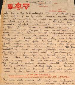
Letter - from Wal Larsen to Wal Jack re the Tenterfield railway, Wal Larsen, Aug 1945
Wal Jack had an extensive range of correspondents throughout Australia and the world who often prepared extensive notes and records for him. This letter from Wal Larsen of Bright, dated 16 Aug 1945 describes a trip to Tenterfield, notes on crews, their hats, station layouts and detailed map. With the letter is a plan of the station layouts of the West Tamworth to Barraba line dated 6-10-45. Demonstrates some of the correspondence that Wal Jack received from around the world and that of Wal Larsen.Letter - handwritten with ink on a set of four ruled Salvation Army - Australian Comfort Fund and YMCA printed sheets and a drawing on a foolscap sheet on the rear of Australian Military Forces for - "Return on Members of the Permanent forces entitled to Medical Attendance"letters, wal jack, railways, nsw, wal larsen, tenterfield, barraba, west tamworth, nswgr -
 Ballarat Tramway Museum
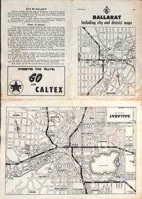
Map, RACV - Royal Automobile Club of Victoria, "Ballarat including city and district maps", 10/1961
... Ballarat RACV Railways Four fold map printed on white paper, titled ...Shows the central part of Ballarat, Ballarat Outlets, streets, principal attractions, Ballarat and district maps and information. Has the tram lines shown dotted, does not run out to Sebastopol or the Lydiard St North terminus. Each map in the bottom left-hand corner has the number "1061", possibly indicating the date. Has notes on the City, points of interest, and an advertisement for Caltex. See item 4929 for a larger version dated 1966. Yields information about the extent of Ballarat in the early 1960's shows the tram lines and other rail lines in the district. Four fold map printed on white paper, titled "Ballarat including city and district maps" - Map No. MAP 15.314 and dated 10-61. Produced by the RACVmap, tranways, ballarat, racv, railways -
 Ballarat Tramway Museum
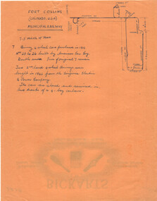
Archive - Notes on Fort Collins Municipal Railway, Wal Jack, c1950
Wal Jack kept extensive notes on railways and tramways around the world, provided by his correspondents and research. This sheet gives details of the Fort Collins Municipal Railway in Colorado USA. The 7.5mile system operated a small fleet of Birney type tramcars. Includes a map of the system. Bickarts were Ballarat Watchmakers and Jewellers.Yields information about type of work undertaken by Wal Jack.Orange colour quarto sheet on the rear of Bickarts' letterhead providing Notes on Fort Collins Municipal Railwayletters, wal jack, archive, usa, records, bickarts, fort collins, birney tramcars -
 Ballarat Tramway Museum
Drawing - Map or Plan, Wanganui Tramways NZ, 1945
Wal Jack had an extensive range of correspondents throughout Australia and the world who often provided him with detailed drawings and notes on various tramway systems. Drawing shows the various lines both railways and tramways, crossing loops, locations and features of the Wanganui NZ tramway system in 1945. Drawn by an unknown person; has an initial in the bottom right hand corner.Yields information about Wal Jack's correspondents and their extensive work.Drawing - red and black ink, colour pencil on foolscap paper of Wanganui Tramways NZ 1945letters, wal jack, drawings, maps, wanganui nz -
 Ballarat Tramway Museum
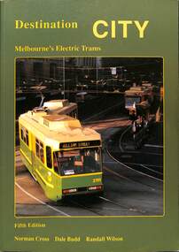
Book, Traction Publications, "Destination City" fifth edition, 1993
Includes brief description of each type, photographs and a summary history, including the Victorian Railway's trams. Has many photographs of the various tramcars associated with relevant text. On front cover is a photo of Z3 at the Burwood terminus. Written by Norm Cross, Dale Budd and Randall Wilson as editors, published by Transit Australia Publishing. Has two maps, north and south of Melbourne, printed on the inside card covers. Published 1993. Yields information up to 1993 about Melbourne's tramcars.Book - "Destination City" with subtitle "Melbourne's Electric Trams" - 128 A4 pages + card card, printed on gloss paper - 7 sections, perfect bound, describes Melbourne's tram car fleet. mmtb, tramways, tramcars, melbourne, vr trams, destination city -
 Ballarat Tramway Museum
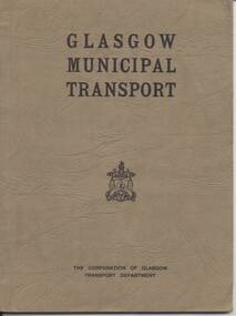
Book, Corporation of Glasgow Transport Department, "Glasgow Municipal Tramway", c1933
Book - 48 pages + 2 fold out maps + cover, card cover, bound, giving details of history of Glasgow tramways, power stations, substations, workshops, bus stations, training and underground railway. Commences at p41 - 92, could have been part of a larger document. Record reviewed and scanned images of cover added 5/9/13. trams, tramways, glasgow, uk, tramway, bus, underground -
 Ballarat Tramway Museum
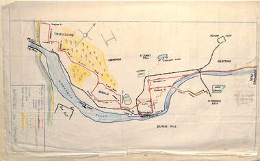
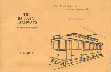
Book, Keith Kings, "The Ballarat Tramways", Sep. 1971
Yields information about the history of the Ballarat Tramways from horse to the closure of the electric trams in 1971. Gives a good understanding of the development and operation of the tramways. Has a strong association with the author.Book, 64 pages, gloss art paper, in black ink with a light brown card cover in green ink, centre stapled, titled "The Ballarat Tramways" Details history of Ballarat tramways, its tramcars and the involvement of the various operators. Has maps and photographs. Written by Keith Kings and published by the Victorian Division of the Australian Railway Historical Society at the time of the closure of the Ballarat system. Inside front cover is a typed sheet of amendments for the book - typed on Charles Martin Watermarked paper. Has details of the various organisations that published the book on the rear cover. 114.2 - as for 114.1 - but with many hand written notes etc. 114.3 - as for 114.1 - but with "City of Ballarat" stamped on front cover. 114.4 - as for 114.1 - but with "To Mr. L. J. Denmead, Departmental Tramways Supt. from K. Kings 12/9/1971" handwritten on front cover. For entire book see pdf images i1 to i3.114.2 - notes on pages 7, 10, 17, 18, 21, 22, 23, 25, 26, 29, 36, 49 and 63 - has in blue or black ink, many notes, corrections and additions. 114.3 - "City of Ballaarat" stamped in red on top right hand corner. 114.4 - "To Mr. L. J. Denmead, Departmental Tramways Supt. from K. Kings 12/9/1971" handwritten on front cover in blue ink and on title page (page 1) in red ink "Mr. L. J. Denmead / Dear Les, / Best Wishes for the future! / Bob Prentice" and on same page, in blue stamp "L.J. Denmead".trams, tramways, ballarat tramways, history, tramcars of ballarat -
 Ballarat Tramway Museum
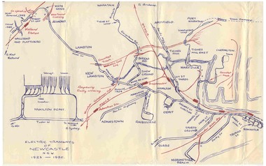
Map, Ken McCarthy, Electric Tramways of Newcastle 1923 - 1950, c1960
Hand drawn red and blue biro map of Newcastle electric tram lines - period 1923 - 1950, showing principal railway lines, tram tracks, crossovers depot layout, level crossings on plain foolscap paper.trams, tramways, newcastle, steam trams, trams, map -
 Ballarat Tramway Museum
Map, Ken McCarthy, Map of Proposed National Park Line - SPER, mid 1950's
Hand drawn plan on plain foolscap paper of proposed tram line from Loftus to View Point within National Park for South Pacific Electric Railways - with notes, proposed destination roll.trams, tramways, sper, national park line, loftus, destination roll -
 Ballarat Tramway Museum
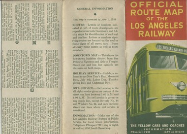
Map, H.P. Noordwal, "Official Route Map of the Los Angeles Railway", Jun. 1938
... Angeles Railway" Map H.P. Noordwal ...A (12 section) fold out map of street car (tram) and bus services for Los Angeles, dated June 1, 1938, showing all LAR (Los Angeles Railway) streetcar and coach (tram and bus) services, Pacific Electric lines within area, detailed "downtown" map, route descriptions and points of interest. Record images added 20/8/2013.Three terminus have been marked with pencil "X". On rear car, next to object number is a symbol looking like a "H & S" merged together.trams, tramways, los angeles, street cars, map -
 Ballarat Tramway Museum
Magazine, Traction Publications, Railways In Australia - Oct/Nov 1950, Nov. 1950
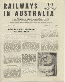
24 page magazine, publisher by Traction publication recording current event in Australia & New Zealand railways & tramways - with photos, advertisements, see list for contents. Railways in Australia The Magazine about Australian Trains, incorporating TRAM TRACKS, the Electric Traction Monthly Contents (Summary) Articles New Zealand Railways - Record Year - pl, 2 and 3 Diesel operation of South line is SAR plan - p2 Comrails plan big improvements - p3 New north line soon for NSWR? - p3 About Locomotives - QGR Garratt's, VR N class, R class, NSW 58, TGR diesels - p4 and 5 Holiday by Rail - C.Einsiedel - Vic and NSW Comparisons are Odious - An American View - PCC tram for MMTB - p9 More Fare increase - Sydney, Melbourne and elsewhere - p10 Operation 'Strike' - Melbourne Trams Handle Crowds - by KSK - p 1 2 and 13 (VR trains on strike) - very interesting. - has map of ~B including authorised lines. High Voltage ~ Electric Railway news - NSW, VR, Gippsland - p 14 Model Railways in Australia - p 1 8 and 19 The Mayfield Lines ( large garden 0 gauge model railway, by L.A. Clark, includes plan - p20 and 2 I.) Photographs NSW steam loco 5801 - pl TGR diesel railcars built by Comeng - p3 NSW 38's - p4 MMTB PCC tram 980 and interior view - p9 Photo of St Louis Car Co. B3 bogie used under PCC car - p10 Perth Trolley Bus - No. 41 - p 1 3 Advertisements McGills Newsagency - p2 John C. Beckett - photographer - p6 Meadmores model engineering Co. - p6 and p 14 WAGR institute magazine - p6 Wattle Park - p7 Australian Model Hobbies - SA - p 1 5 Traction Publications - p 1 5 The Main Hobby Depot - Melbourne - p 1 5 Railway Destination Rolls, LA Clark - pl 5 Model repairs - R.Pearson - p19 Hearn's Hobbies- p21 The Hobby Shop p21 Herbert Small - p21 Australia Railway Models - p22 Scale Model Railway Equipment - p23 Bames Tennis Centre - p23 Traction publications listings and books etc. - p24 - and where to purchase magazine. Amalgamated Blind and Tent Co. - p24 Other List of office bearers and general information for ARLHS Obituary for Maj Gen. A.C.Fewtrell Chief Civil Engineer for NSWGR Tramway news - Sydney King St. Closure, Wanganui system closure, Latrobe St. Melbourne, Melbourne VR trams, SEC trams purchasing maximum traction trams, Launceston, Hobart, Kalgoorlie - p I 1, Brisbane, Perth and Adelaide - p I 5 Drawing of Adelaide H class trams - p 1 9 Club noticeboard, and Question box - on Outer circle Railway. Wad 25.11.95 Record images added 20/8/2013. trams, tramways, australian railways, new zealand railways, model railways, model tramways -
 Ballarat Tramway Museum
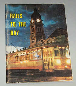
Book, R.T. Wheaton et al, "Rails to the Bay", 1971
84 page book on the Adelaide to Glenelg tram (interurban in style) line with colour covers, maps, black and white photographs, including railway era. Published for the 40th anniversary of opening, in 1971.On top of p3, - 3.00 k8 in pencil.trams, tramways, adelaide, glenelg, interurban, tramways -
 Ballarat Tramway Museum
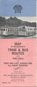
Map, Survey and Mapping for MMTB, "Map of Melbourne's Trams and Bus routes and all night services", Jan. 1967
Fold out sheet coloured map, 12 portions or folds, - title - "Map of Melbourne's Trams and Bus routes and all night services" map shows trams lines, route numbers, terminal points, bus routes, railway lines, blow up of city area with places of interest and key. On rear details, places of interest, suburb index, index to routes, first and last services, Sunday am services, all night bus services and locations of depots and head office. 2nd copy added 11-8-2006. Images of document - scanned to A3 size and overlapping added 30/10/13 On rear "out of date" stamp and 1 "cancelled" stamp - red ink.trams, tramways, melbourne, map, tram & bus services, all night services -
 Ballarat Tramway Museum
Document - Guide Book/notes, Tramway Museum Society of Victoria (TMSV), "Guide for Delegates interested in trams", 1970
Demonstrates notes prepared by the TMSV for tours of the Ballarat and Melbourne systems and the nature of the notes.Five page spirit duplicated notes to act as a guide to visitors to the International Convention of Railway Modellers, Melb. 1970. Index, history of TMSV, map of Malvern depot, model trams, exhibition notes, place of Melb. Tram interest, notes and map on Ballaarat. Missing is pages 6, 7, and 8 - noted in index on page 1. Pdf image of document added 31/10/2013.trams, tramways, melbourne, ballarat, tmsv, model tramways -
 Ballarat Tramway Museum
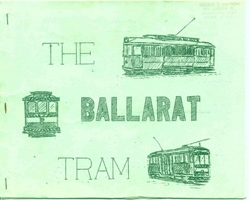
Book, A. Weston & Geoff Clark of North Sydney Boys High School, "The Ballarat Tram", Jul. 1971
Produced by the North Sydney Boys High School Railway club, prior to the closure of the Ballarat system - little else written and published at the time about the history and details of the system. A very good booklet for the time - produced entirely by the wax cut stencil process. Has a strong association with the people who prepared the document.Twenty page booklet on the history, operation and tramcars of Ballarat, produced by the Nth Sydney Boys High School Railway Club in July 1971. Printed on a wax cut stencil process, with green covers, drawings, maps, track layout, fleet list, gives tentative closure dates, route descriptions, sketches, stapled on edge. Title "The Ballarat Tram". Stapled on the left hand side. Three copies held - 3rd copy added 22/10/05. 4th copy added 11/10/2007 and image of cover added as well. pdf image of copy added 2/11/13 - to produce the scan, copy 2 was unstapled and filed loose - may not open properly in dbtext. find file and open directly. See Reg Item 6388 for the Bendigo version.3rd copy - page 3 - in black ink "Ballarat Tramway Preservation Society Catalogue No. 118", On top right hand corner "Graeme Breydon address stamp"trams, tramways, ballarat trams, secv, tramcars -
 Ballarat Tramway Museum
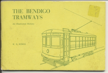
Book, Keith Kings, "The Bendigo Tramways", Feb. 1972
Book, 80 pages, gloss art paper, in black ink with a yellow card cover in green ink, centre stapled, titled "The Bendigo Tramways" Details history of Bendigo tramways, its tramcars and the involvement of the various operators. Has maps and photographs. Written by Keith Kings and published by the Victorian Division of the Australian Railway Historical Society and others at the time of the closure of the Bendigo system. Has details of the various organisations that published the book on the rear cover. Cover, index page, maps and rollingstock lists have been scanned see jpg images i1 to i7 For book itself see pdf images i1 to i4 326.1 - ditto - purchased by W.A. Doubleday for BTM ex Scottsbluff, NE, USA 8/2003. Added 27/09/03. See Reg Item 4242 for other copies of this book which has pencil annotations.trams, tramways, bendigo, battery trams, steam trams, history -
 Kew Historical Society Inc
Plan, Melbourne & Metropolitan Board of Works : Contour Plan of Melbourne & Suburbs : Melbourne Sewage, 1894
The Melbourne and Metropolitan Board of Works (MMBW) plans were produced from the 1890s to the 1950s. They were crucial to the design and development of Melbourne's sewerage and drainage system. This plan forms part of a large group of MMBW plans and maps that was donated to the Society by the Mr Poulter, City Engineer of the City of Kew in 1989. Within this collection, thirty-five hand-coloured plans, backed with linen, are of statewide significance as they include annotations that provide details of construction materials used in buildings in the first decade of the 20th century as well as additional information about land ownership and usage. The copies in the Public Record Office Victoria and the State Library of Victoria are monochrome versions which do not denote building materials so that the maps in this collection are invaluable and unique tools for researchers and heritage consultants. A number of the plans are not held in the collection of the State Library of Victoria so they have the additional attribute of rarity.Digital copy of an original MMBW plan. This contour plan shows the area identified by the MMBW for purposes of drainage and sewerage in 1894. The suburbs represented extend from Williamstown in the west to Bulleen in the east, and from Preston in the north, south to Sandringham. Suburbs are outlined in coloured ink. Red lines indicate main and branch sewers in existence at the beginning of 1894 in central and inner Melbourne. These extended as far as Williamstown and Brighton, but not yet as far as Kew, where sewering did not commence until 1901. Contour lines show the topography, which was important for indicating the fall of the land for the laying of sewers and drainage channels. Kew appears to be fairly undeveloped at this date except for railway lines and stations (the Kew and Outer Circle lines), main roads, the Kew Lunatic Asylum Reserve and Studley Park. However, the contour plan does not accurately represent the density of settlement, nor the large number of houses, which were being built in Kew and other suburbs from the 1850s to the land boom of the late 1880’s and early 1890’s. This plan is part of a large and historically significant group of MMBW plans and maps that was donated to the Society by the Mr Poulter, City Engineer of the City of Kew in 1989.mmbw contour plan of melbourne and suburbs, melbourne and metropolitan board of works, melbourne sewage, cartography -
 Kew Historical Society Inc
Plan - Subdivision Plan, H C Crouch, Old Golf Links Estate, 1930s
The land in North Kew between the Outer Circle Railway and the River Yarra was released in sections. This release included 80 lots. Most of this area was released during the Depression years in the early 1930s.Subdivision plans are historically important documents used as evidence of the growth of suburbs in Australia. They frequently provide information about when the land was sold on which a built structure was subsequently constructed as well as evidence relating to surveyors and real estate and financial agents. The numerous subdivision plans in the Kew Historical Society's collection represent working documents, ranging from the initial sketches made in planning a subdivision to printed plans on which auctioneers or agents listed the prices for which individual lots were sold. In a number of cases, the reverse of a subdivision plan in the collection includes a photograph of a house that was also for sale by the agent. These photographs provide significant heritage information relating house design and decoration, fencing and household gardens.One part of a massive subdivision of the Old Golf Links Estate in North Kew of 80 allotments bordering Sutherland Avenue, Ramsay Avenue, Belford Road, Beresford Street and Coleman Avenue. Inset on the plan at the top left, the route of the Outer Circle Railway is clearly marked. The Kew Golf Links is identified in its current location. The land on which Greenacres Golf Club was to be constructed is at this time marked as ‘Recreation Ground’. The ‘new bridge’ over the Yarra at Burke Road is also marked on the inset map. The Plan identifies the surveyor (sic) H.C. Crouch BCE MVIS, 443 Little Collins St., Melbourne. The date of the subdivision auction sale in identified as Saturday September 25th at three o'clock.Annotations: "E" top left. "Golf Links" top right. Lots 73-76 ticked and listed as "6" poundssubdivisions -- kew (vic.), old golf links estate -
 Kew Historical Society Inc
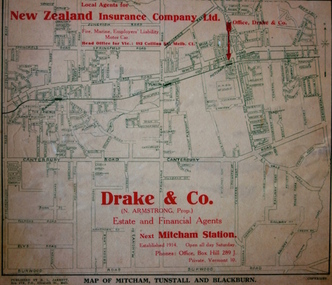
Map - Street Map, R L Jarrett, Map of Mitcham, Tunstall and Blackburn, 1929
Tunstall was originally the name of Nunawading Railway Station. Tunstall opened on 4 June 1888 and was renamed on 1 November 1945. An historically significant advertising map that can be used to ascertain the extent of urban development in 1929 in the areas of Nunawading, Blackburn and Mitcham.A map of Mitcham, Tunstall and Blackburn found on the reverse of a real estate subdivision plan published by R. L. Jarrett of Elizabeth Street. This promotional street map is overprinted with the business address of the sponsors and advertising. Map overlaid in red print: "Drake & Co. / (N. Armstrong, Prop.) / Estate and Financial Agents / next Mitcham Station / Established 1914. Open all day Saturday. / Phones: Office, Box Hill 289 J. / Private, Vermont 10."real estate agents, mitcham, tunstall, blackburn, road maps, drake & co, new zealand insurance co ltd -
 Kew Historical Society Inc
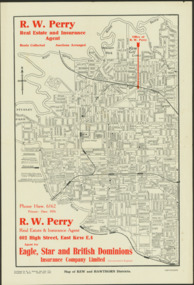
Map - Map of Kew and Hawthorn Districts
... to the former Outer Circle Railway. Map Map of Kew and Hawthorn ...Map of Kew, East Kew and Hawthorn produced for a Kew Real Estate Agent, RW Perry. The map is undated.Two-colour map of Kew and Hawthorn Districts produced for by R.L. Jarrett for RW Perry, Real Estate & Insurance Agent. The map has unusual features such as a planned railway link from Kew Station to the former Outer Circle Railway. RW Perry / Real Estate & Insurance Agent, 602 High Street, East Kewmaps - kew (vic), maps - hawthorn (vic), r.w. perry, real estate agents -- kew (vic.) -
 Kew Historical Society Inc
Journal, The Kewriosity Sheet Vol.3 No.10 : May 1982
Introducing your North Ward councillors - Cr R.C. McCausland, Cr Martin Solomons, Cr J. Ormando [Political profiles; Kew City Council] / p1. Kew Recreation Programme / p2. What's on in Kew for May / p2. See touch and taste group presentations / p2. C.A.B. [Kew & Hawthorn Citizens Advice Bureau] / p3. Super quiz night to aid M.S. [Multiple Sclerosis Society] / p3. Volunteer drivers needed [Kew Community Bus] / p3. Kew Uniting Church Bushwalking Group / p3. Introducing hydroponics [Kew Garden Club] / p3. Kew-Hawthorn Uniting Church Youth Group / p3. Historic booklets on Kew ['Touring Round Kew'; The Artists of Kew'; 1875 Map of Kew / p3. Kew's railway / Barbara Giles p4. Sacred Heart [Church] Caring Group / p4. Karana Auxiliary Project / p4. Scrabble / p4. Kew Festival [Rheumatism and Arthritis Association Kew Self Help Group] / p4.The Kewriosity Sheet (1979-83) was first published in the City of Kew (Victoria) in June 1979 as a two-sided 'community newssheet'. It aimed to: 'share news about Kew happenings and Kew people, and to exchange ideas about living in Kew'. Later issues gradually evolved into a 4-page, quarto sized publication. The Kewriosity Sheet was superseded by the Kew Council publication 'Kewriosity' (1983-1994).non-fictionIntroducing your North Ward councillors - Cr R.C. McCausland, Cr Martin Solomons, Cr J. Ormando [Political profiles; Kew City Council] / p1. Kew Recreation Programme / p2. What's on in Kew for May / p2. See touch and taste group presentations / p2. C.A.B. [Kew & Hawthorn Citizens Advice Bureau] / p3. Super quiz night to aid M.S. [Multiple Sclerosis Society] / p3. Volunteer drivers needed [Kew Community Bus] / p3. Kew Uniting Church Bushwalking Group / p3. Introducing hydroponics [Kew Garden Club] / p3. Kew-Hawthorn Uniting Church Youth Group / p3. Historic booklets on Kew ['Touring Round Kew'; The Artists of Kew'; 1875 Map of Kew / p3. Kew's railway / Barbara Giles p4. Sacred Heart [Church] Caring Group / p4. Karana Auxiliary Project / p4. Scrabble / p4. Kew Festival [Rheumatism and Arthritis Association Kew Self Help Group] / p4. community publications --- kew (vic.), the kewriosity sheet, newsletters - kew (vic.) -
 Kew Historical Society Inc
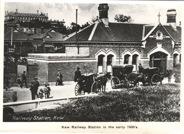
Print, Kew Railway Station in the early 1900s, c.1900
Kew Railway Station (1887-1959). ‘Kew Railway Station’ in Denmark Street was the terminus of the Kew Line, which extended from Hawthorn Station to just south of Wellington Street. The Station opened on 19 December 1887 after a prolonged campaign for a railway by the people of Kew. Due to a decline in patronage, the passenger service ceased operations in August 1952. While a freight service continued for another five years, the line and station were officially closed on 13 May 1957. Subsequently demolished in 1959, the headquarters of VicRoads (formerly Country Roads Board) now stands on the former Station site.This work forms part of the collection assembled by the historian Dorothy Rogers, that was donated to the Kew Historical Society by her son John Rogers in 2015. The manuscripts, photographs, maps, and documents were sourced by her from both family and local collections or produced as references for her print publications. Many were directly used by Rogers in writing ‘Lovely Old Homes of Kew’ (1961) and 'A History of Kew' (1973), or the numerous articles on local history that she produced for suburban newspapers. Most of the photographs in the collection include detailed annotations in her hand. The Rogers Collection provides a comprehensive insight into the working habits of a historian in the 1960s and 1970s. Together it forms the largest privately-donated collection within the archives of the Kew Historical Society.A photographic copy of a book plate from 'Kew's Civic Century' (1960) by W.D. Vaughan. The book plate was itself a copy of an early 20th century postcard depicting the Kew Railway Station."Railway opened 1887 - Then as photo states"kew railway station, dorothy rogers, country roads board, vicroads -
 Kew Historical Society Inc
Map, MMBW, MMBW Plan No.67 Kew, 1900-1910
The Melbourne and Metropolitan Board of Works (MMBW) was established by an act of the Victorian Parliament in 1890 to prepare for and to implement a sewerage and water reticulation system across what was then inner Melbourne, its surrounding and middle distance suburbs, including Kew. The MMBW was disbanded in 1991.The map collection of the Kew Historical Society has at its core the historic maps assembled and originally stored in the City Engineer's Department of the City of Kew. These include maps in a number of scales. The vast majority of maps were produced by the MMBW in the first two decades of the twentieth century, and are solid working maps, backed by linen for durability. These maps are historically significant to Kew, the City of Boroondara and to the history of the development of state utilities in Victoria. A number of the Kew maps have additional details added by former municipal officers, including the levels reached by various floods. As these were working documents, information was added to them long after the period of their initial production and distribution.Early map of part of the Borough of Kew, created in the first decade of the twentieth century, at a scale 160 ft to 1 inch. The map covers what was then the north central part of Kew, bordered on its north by the Outer Circle Railway Spruzen and Beresford Avenues, in the west by Princess Street, in the south by High Street, and in the east by (about) Belford Road. The map shows the extent of urban development by that time, prominent institutions and the outlines of built structures in the municipality. Contour lines were added in ink to the map at a later stage.MELBOURNE AND METROPOLITAN BOARD OF WORKS / PLAN NO. 67 / KEW melbourne & metropolitan board of works, mmbw maps, mmbw plans, borough of kew, cartography -
 Kew Historical Society Inc
Map, MMBW, River Yarra Beautification Schemes, c.1913
The Melbourne and Metropolitan Board of Works (MMBW) was established by an act of the Victorian Parliament in 1890 to prepare for and to implement a sewerage and water reticulation system across what was then inner Melbourne, its surrounding and middle distance suburbs, including Kew. The MMBW was disbanded in 1991.The map collection of the Kew Historical Society has at its core the historic maps assembled and originally stored in the City Engineer's Department of the City of Kew. These include maps in a number of scales. The vast majority of maps were produced by the MMBW in the first two decades of the twentieth century, and are solid working maps, backed by linen for durability. These maps are historically significant to Kew, the City of Boroondara and to the history of the development of state utilities in Victoria. A number of the Kew maps have additional details added by former municipal officers, including the levels reached by various floods. As these were working documents, information was added to them long after the period of their initial production and distribution.Map of the City of Kew showing part of the River Yarra Beautification Schemes. The map shows development to date and the flood levels reached in 1923 and 1924. This map may have been adapted from an earlier map, as most development in central Kew and Studley Park had occurred by this date yet numerous streets are not represented. Public buildings and institutions are clearly represented and named on the map as are significant public transport infrastructure (eg the Outer Circle railway).MELBOURNE AND METROPOLITAN BOARD OF WORKS / RIVER YARRA BEAUTIFICATION SCHEMES / SCHEME / SCALE 10 CHAINS TO AN INCHmelbourne & metropolitan board of works, mmbw maps, mmbw plans, city of kew, flood levels -- kew (vic.), cartography -
Surrey Hills Historical Society Collection
Archive - Vertical file, Armitstead family
The Armitstead family's first woodyard in Surrey Hills was located in Croydon Road but later they moved to 153-157 Union Road, Surrey Hills. The business delivered timber and briquettes for heating to homes in the local area but also blocks of ice in the days before refrigerators were a usual household appliance. The timber was unloaded from railway trucks at a siding at Surrey Hills station; some came from the Armitstead's property of 130 acres of timbered land near Killara. They also sold mallee roots and briquettes.A vertical file containing the following documents: 1. Land Victoria map of Surrey Hills including Union Road from Bedford Street to Montrose Street, showing location of woodyard (undated) (1 A3 page). 2. Possibly ‘Sun’ article ‘When Surrey Hills ran short of wood’, Michael Sefton (undated) (1 page). 3. Plaque for the red mechanism of the weighbridge at Centre, by convenor, Surrey Hills Heritage Group, 12.11.2002 (1 page). 4. Pooley and Sons weighbridge, notes by Dennis Armstrong, in email to Sue Barnett, 4.4.2013 (2 pages). 5. Laminated diagram and notes by Ken Hall re weighbridge from Armitstead’s woodyard, and photocopy, undated (3 pages). 6. ‘Armitstead’s woodyard’ 153-7 Union Road (now Neighbourhood Centre), typed Progress Leader article, 13.1.1982 (2 pages). pooley and sons weighbridge, armitstead family, woodyard, armitstead's woodyard, union road -
 Sunbury Family History and Heritage Society Inc.
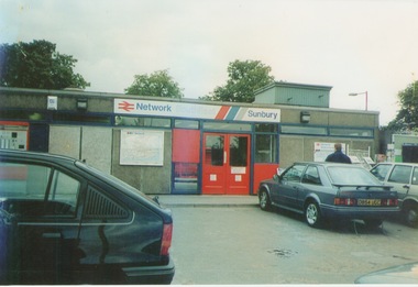
Photograph, September 1996
The photograph shows the railway station at Sunbury in Surrey in the United Kingdom. The town of Sunbury in Victoria was named after the English township of Sunbury-on-Thames in Middlesex by the Jackson Brothers who took up land in Sunbury, Victoria. The area was originally known as Koora Kooracup by the Wurundjeri people.Sunbury in Victoria like many other settlements in Australia were given names of towns in the United KingdomA coloured photograph of a railway station with three cars parked outside the building, which has grey walls and scarlet and blue trims. There are framed maps and notices on the exterior walls. -
 Beechworth Honey Archive
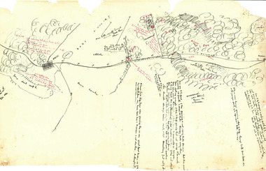
Hand-Drawn Map Centred on Ararat by Frank Lebbell Frost December 1916
This is one of the maps drawn by Frank L. Frost while he was beekeeping in North-East Victoria. This particular map may be reference in the "Wooden" Diary on page 11. Front Side: Hand-drawn map centred on Ararat, central Victoria. Details road and railway and vegetation with comments on flowering. Back Side: Comments in grey lead [ca 1923]hand drawn, hand-drawn, map, ararat, frost, beekeeper, beechworth honey -
Beechworth Honey Archive
Map- Everton
Map compiled from 1975 aerial photography. Printed in 1979.Map shows Everton, Ovens River, Beechworth- Wangaratta Rd, former Wangaratta- Bright railway. Scale 1:25,000. Printed colour on paper.Map labelled Everton. No. 8225-3-3.map, everton, ovens river, bright, railway, aerial, photography, paper, beechworth honey -
 Surrey Hills Historical Society Collection
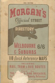
Book, Morgan's Official Street Directory, c1940s
incl.index. This Street Directory of Melbourne and suburbs, c1940s, includes a list of suburbs, their mileage from the city and how to reach them; an index to localities as well as the index to streets appearing on the maps. It also shows bus routes, railways and tramways routes on the maps.incl.index. This Street Directory of Melbourne and suburbs, c1940s, includes a list of suburbs, their mileage from the city and how to reach them; an index to localities as well as the index to streets appearing on the maps. It also shows bus routes, railways and tramways routes on the maps.melbourne metropolitian area, suburbs, cities and towns, maps