Showing 1067 items matching "over the river"
-
 Wodonga & District Historical Society Inc
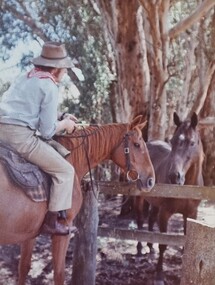
Album - Ringer's River by Des Martin - Plate 8 - O'Day meets Grapeshot
Pushing his mob along the back boundary of Barmagulla Station, whose owner, Edmund Montieth, a wealthy, well educated, and forward thinking gentleman accepted as a leader of the N.S.W. pastoralists "just across the border", O'Day hears the shrill whinny of a stallion. On riding over to investigate he finds that, in the practise of the day, a superb thoroughbred horse has been turned out on the river flats to acclimatise. Later he learns that this is Grapeshot, a classic winner just imported from England.The albums and images are significant because they document literature written by a prominent member of the Wodonga community. The presentation of this precis was supported by several significant district families and individuals.Ringer's River Album Coloured photo Plate 8des martin, many a mile, ringer's river, northeast victoria stories -
 Wodonga & District Historical Society Inc
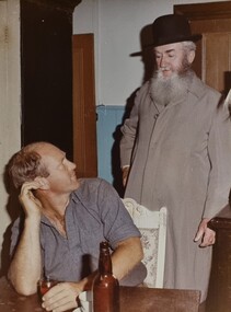
Album - Ringer's River by Des Martin - Plate 2 - MacLough sacks Neilson as manager of "Gooloora"
MacLough surprises Neilson, erstwile manager of "Gooloora", breakfasting off a bottle of whisky and a cup of black tea, and sacks him on the spot. Ordering the hands to be called together he looks them over and queries the absence of young O'Day. Jackeroo Reg Apperton tells him O'Day is out mending a fence at the back of the stud paddock, and MacLough commands that Apperton drive him out there forthwith. D. Hartsman as Neilson.The album and images are significant because they document literature written by a prominent member of the Wodonga community. The presentation of this precis was supported by several significant district families and individuals.Ringer's River Album Coloured photo Plate 2des martin, many a mile, ringer's river, northeast victoria stories -
 Wodonga & District Historical Society Inc
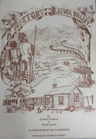
Book - A History of the Kiewa Valley, Esther Temple et al, 1989
This book briefly covers the period from the indigenous tribes who lived in the valley well before English settlers arrived. It documents the transformation of the area from a pristine valley environment to one that has been gradually over 200 years to a more commercial rural/industrial landscaped valley. The book details the first pioneers and their descendants, along with the changes to their environment.This book briefly covers the period from the indigenous tribes who lived in the valley well before English settlers arrived. It documents the transformation of the area from a pristine valley environment to one that has been gradually over 200 years to a more commercial rural/industrial landscaped valley. The book details the first pioneers and their descendants, along with the changes to their environment.kiewa river valley, pioneers victoria, kiewa valley social life and cusstoms -
 Wodonga & District Historical Society Inc
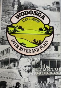
Book - Wodonga Over River and Plain, Alan J. Dunlop, 1976
... Wodonga Over River and Plain...Wodonga Over River and Plain... to Belvoir then later back to Wodonga. Wodonga Over River and Plain ...A great local history of the Wodonga area. Starts with discussion of the Aboriginal inhabitants of the region and early contacts with European explorers and settlers. Explains the establishing of a customs post with its twin city Albury on the other side of the Murray River. The town grew subsequent to the opening of the first bridge across the Murray in 1860. Originally named Wodonga, its name was changed to Belvoir then later back to Wodonga.non-fictionA great local history of the Wodonga area. Starts with discussion of the Aboriginal inhabitants of the region and early contacts with European explorers and settlers. Explains the establishing of a customs post with its twin city Albury on the other side of the Murray River. The town grew subsequent to the opening of the first bridge across the Murray in 1860. Originally named Wodonga, its name was changed to Belvoir then later back to Wodonga.victoria. wodonga, settlers wodonga, indigenous australians wodonga -
 Wodonga & District Historical Society Inc
Book - A Baranduda History, Howard C Jones, 1988
A history of Baranduda in Northeast Victoria. Baranduda is a rural area and, since the 1970s, a rural and residential locality formed under the authority of the Albury Wodonga Development Corporation. It is near the junction of Yackandandah Road and the Kiewa Valley Highway, 10 km south-east of Wodonga. This publication traces the history of the area from its earliest know indigenous inhabitants, through the days of the earlier establishment of pastoral runs to more recent developments.Spiral boundnon-fictionA history of Baranduda in Northeast Victoria. Baranduda is a rural area and, since the 1970s, a rural and residential locality formed under the authority of the Albury Wodonga Development Corporation. It is near the junction of Yackandandah Road and the Kiewa Valley Highway, 10 km south-east of Wodonga. This publication traces the history of the area from its earliest know indigenous inhabitants, through the days of the earlier establishment of pastoral runs to more recent developments.baranduda, pioneers victoria, huon family, wodonga pioneers -
 Wodonga & District Historical Society Inc
Book - Let's Have Water - A history of the Fish River Water Supply, Robin McLachlan, Denis Barrett, Jack Domis, Nick Welling, 1997
A history of the development of the management of the Fish River Water Supply Scheme in Central NSW. The scheme extends across the local government areas of the Shire of Oberon, the City of Lithgow and the City of the Blue Mountains.non-fictionA history of the development of the management of the Fish River Water Supply Scheme in Central NSW. The scheme extends across the local government areas of the Shire of Oberon, the City of Lithgow and the City of the Blue Mountains.water nsw, fish river region nsw, oberon dam, water resources development nsw australia -
 City of Kingston
Photograph - Colour, 31 January 1993
Patterson Lakes is a suburb in the City of Kingston that is built one kilometre upstream of the mouth of the Patterson River. The area is bordered by the Patterson River and Eel Race Drain which enters the Kananook Creek. The suburb consists predominantly of newer housing developments and the tidal canal system of the development joins Port Phillip Bay. Patterson Lakes and the Kananook Creek were previously part of the extensive Carrum Carrum Swamp. The area was once a source of fish and eels for the Mayone-Bulluk clan of the Bunurong people. Over time the area was drained and in 1973 investigations commenced into the development of a unique residential area that would be built adjacent to canals and waterways. It was originally proposed to be known as "Gladesville". The development would give the suburb's homeowners access to Port Phillip Bay "from their back door". Circa 1974, the area was rezoned from rural to residential and named Patterson Lakes. Development has been continuous since the 1970s with construction of residential housing, schools, shopping centres, marinas, a hotel and library.Laminated colour aerial photograph of the Carrum and Patterson Lakes region within City of Kingston. This 1993 image includes Patterson River Secondary College, Roy Dore Reserve, Kananook Creek and Nepean Highway. The railway line can be seen as it veers inland from Eel Race Road, Seaford. The section of Ocean Reef Drive and Palm Beach Drive in Patterson Lakes appears to be a recent development with many spare blocks and new houses under construction.Black typed lettering on white adhesive label: 31.1.93 Black typed lettering on white adhesive label: 27E/7140 31/1/93 12.55 pm Black typed lettering on white label: 7140 Yellow round adhesive label located on left sidepatterson lakes, seaford, kananook creek, carrum carrum swamp, canals and waterways -
City of Kingston
Photograph - Colour, c. 1993
Patterson Lakes is a suburb in the City of Kingston that is built one kilometre upstream of the mouth of the Patterson River. The area is bordered by the Patterson River and Eel Race Drain which enters the Kananook Creek. The suburb consists predominantly of newer housing developments and the tidal canal system of the development joins Port Phillip Bay.Patterson Lakes and the Kananook Creek were previously part of the extensive Carrum Carrum Swamp. The area was once a source of fish and eels for the Mayone-Bulluk clan of the Bunurong people. Over time the area was drained and in 1973 investigations commenced into the development of a unique residential area that would be built adjacent to canals and waterways. It was originally proposed to be known as "Gladesville". The development would give the suburb's homeowners access to Port Phillip Bay "from their back door". Circa 1974, the area was rezoned from rural to residential and named Patterson Lakes. Development has been continuous since the 1970s with construction of residential housing, schools, shopping centres, marinas, a hotel and library.Laminated colour aerial photograph of the Carrum and Patterson Lakes region within City of Kingston. This 1993 image includes Patterson River Secondary College, Roy Dore Reserve, Kananook Creek and Nepean Highway. The railway line can be seen as it veers inland from Eel Race Road, Seaford. The section of Palm Beach Drive, Curlew Point Drive, Snapper Point Drive, Clipper Island and Myola Street in Patterson Lakes appears to be a recent development with many spare blocks and new houses under construction.patterson lakes, seaford, kananook creek, carrum carrum swamp, canals and waterways -
City of Kingston
Photograph - Colour, 1993
Carrum is a suburb in the City of Kingston bordered by the Patterson River in the north and Kananook Creek in the south. To the east the suburb is adjacent to Patterson Lakes. The Carrum Station was opened in 1882, when the railway line from Mordialloc was extended to Frankston. In the early 20th century, it was a destination for holidaymakers occupying tents and cabins. The area now consists of older housing and over time there have been many new housing developments.Carrum is located in the area that was originally part of the Carrum Carrum Swamp. The district had originally been the home of the Bunerong people who fished, gathered food and found refuge in the sand dunes. The Swamp was drained in 1879 when the Patterson Cut was formed and became known as Patterson River. Apart from local farmers, fishermen and hotel-keepers, there were few permanent residents until the early 20th century when it had become popular as a beach resort. In the 1920s and 1930s the area became occupied by more permanent residents.Laminated aerial colour photograph of Carrum and Patterson Lakes in the City of Kingston. The photograph also includes Kananook Creek and the northern section of Seaford. Prominent features include Roy Dore Reserve, Carrum Primary School, Patterson River Secondary College, Keast Park Seaford, the Seaford Swamp Drain and a section of Downs Estate situated on the traditional lands of the Bunurong people.Black type on white adhesive sticker: No. 7140 Black type of white adhesive sticker: 31-1-93 Black handwritten ink (marker): * [an asterisk] Yellow circular adhesive stickerpatterson lakes, seaford, carrum carrum swamp -
 Melbourne Legacy
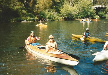
Photograph, Junior Legatee Camp 1987, 1987
Photographs of Junior Legatees kayaking on the McAllister River in Licola. Melbourne Legacy arranged many events for Junior Legatees to experience. Including an annual two week camp, usually in January. The venue varied over the years. It was with a group of photos from the 1990's in a folio with paper labels. It is possible these photos are from two different dates. The one that is labelled as Licola 1987 is on different photographic paper to the other four photos.A record of events run for Junior Legatees by Melbourne Legacy.Colour photo x 5 of kayaking on McAllister River in 1987.Handwritten on reverse of 01843.1 '1987 McAllister River Licola'junior legatee outing, camp, kayaking -
 Melbourne Legacy
Article, Bulletin VALE Legatee William Donovan Joynt
An article from the Melbourne Legacy Bulletin on the death of Legatee Donovan Joynt VC. a long serving Legatee. The Bulletin published articles on Legatees when they passed away. When Legatee Joynt passed away on 5 May 1986, he was the club's oldest member and was an original member of the Legacy movement from 1923. The article includes his service to Legacy. It mentions his war service beginning with joining the Victorian Rifles in 1911. He served with the 8th Infantry battalion in Egypt and Europe. He was mentioned in despatches for conspicuous service in 4 famous battles, Ploygon Wood, at Guerudecourt, at River Lys defending Hazebrouck and when he won the VC at Chuignes near Villers-Bretonneux. See also his citation at 02024. He served again in the Second World War. It also recounts his employment and travels over the years. He was involved with Colart Studios and it grew into printing company WD Joynt & Co Pty Ltd which became Dominion Press. The article was part of an album of past presidents and prominent legatees from 1965 to 1989. The folder included biographical details and obituaries, eulogies and death notices of prominent Legatees. The items have been catalogued separately.A record of Legatee Donovan Joynt. The information was collected to record the lives of prominent legatees in a folder.Typed copy of 3 pages from the Legacy Bulletin on the death of Legatee William Donovan Joynt.vale, donovan joynt -
 Sunbury Family History and Heritage Society Inc.
Photograph, Rosa McCall, The Nook, 25th September 1997
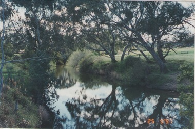
The photograph of The Nook is one of a series of photographs that was included in an exhibition organised by the former Sunbury & District Heritage Association in March 2001 and displayed in the George Evans Museum. Local; people were invited to submit photographs for the exhibition. The Nook is a major recreational area in Sunbury and over the years out has been an areas where grazing and cereal growing was practised before it became the original town's swimming area before the Aquatic Centre was opened in Ligar Street in 1966.Jacksons Creek at The Nook was the site of the original Sunbury Swimming Club for 49 Years from 1917 to 1966, when the Aquatic Centre opened in Ligar StreetA non-digital coloured photograph of river with trees growing along the banks and open ground across the river flats.the nook, swimming, sunbury swimming club -
 Flagstaff Hill Maritime Museum and Village
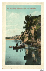
Postcard - Scenic - Warrnambool, Bay of Biscay, Hopkins River, Warrnambool, 1902-1910
The nine postcards in this set were donated together and date to the early 1900s. All but one postcard in this set shows images of Warrnambool, in the Western District of Victoria; the other has a London image. The postcards were all printed in Great Britain according to that country’s postal regulations. The fronts of all cards have titles printed in red. Most of the images on the cards are attributed to photographer Joseph Jordan and belong to the Jordan Series. The back of these cards has an outline for a postage stamp, a vertical dividing line and a heading on each side of the line to separate the Correspondence from the Address. Postcards or ‘correspondence cards’ appeared in Britain in 1894. They were plain cards with a space for the message on one side and an address on the other; regulations didn’t allow anything but the address to be written on the ‘address’ side. In 1902 the British regulations then allowed a picture to be printed on the front and the address on the back, so messages had to be written on the picture side. Soon, the regulations changed and the back was divided for a message and the address. Bay of Biscay, Hopkins River, Warrnambool – This same image was published in Table Talk on January 6th, 1910 and in The Age, on December 18, 1929, referred to a revival of fishing at the Bay of Biscay on the Hopkins River. These and similar articles showcased the Bay of Biscay as a popular boating and fishing location and well worth promoting to places outside of Warrnambool. Joseph Jordan - Joseph Jordan was born in 1841 in Leicester England. When he was 16 he joined the 7th Queen's Own Hussars and was sent to India at the outbreak of the mutiny. He took part in the relief of Lucknow and remained in India for eleven years. It was during this time that he became interested in photography. He was posted to New Zealand and later came to Victoria, becoming a sergeant major of the Mounted Rifles. In the mid-1880s he came to the Western district where he was responsible for establishing units of the Mounted Rifles in various country towns such as Dunkeld, Mortlake, Panmure, Bushfield, Koroit etc. He resigned from the army in 1889 and set up a professional photography studio in Liebig Street, Warrnambool. He became very well known in the Western District for family photographs, official photographs of local councillors and groups as well as views of local scenery. In 1891 he photographed the wrecked barque ‘Fiji’ at ‘Wrecks Beach’ near Princetown. His business was taken over by his son Arthur around 1917. Joseph was a keen rifle shot and in 1924 he donated the "Jordan Shield" as a prize to the Victorian Rifle Association. He was made a "Life Honorary Member" of the Warrnambool Returned Soldiers League and in 1933 he was recognised as being the oldest living soldier in Victoria. Joseph died in 1935 aged 95.The image of the figures in a row boat on the river suggests that the location was a popular place to visit. The choice of subject for this postcard indicates the popularity of Warrnambool's natural environment as a tourist attraction at a time when ships called coastal traders brought passengers and cargo to the Port of Warrnambool from ports along Victoria's southwest coast. Joseph Jordan is a significant figure in Warrnambool history as he helped to establish early units of the Mounted Rifles (G Company) in local towns during the late 1880's and later, photographed local scenes, groups and citizens of early Warrnambool.Postcard, one of nine, portrait orientation, coloured print within a rectangle border with an impressed line around the image and a title in red. The picture shows three figures wearing hats in a rowboat on the bank of a river beside cliffs. There is no correspondence written on the card. The back has inscriptions and outlines for a postage stamp. Jordan Series, printed in Great Britain.Front, in red: “Bay of Biscay, Hopkins River, Warrnambool” Back in green: “Jordan Series” “POST CARD” “PRINTED IN GREAT BRITAIN” “For correspondence” “The Address only to be written here”flagstaff hill maritime museum, flagstaff hill maritime village, flagstaff hill maritime museum and village, maritime museum, warrnambool, great ocean road, warrnambool and district, warrnambool scenes, local scenes, views of warrnambool, joseph jordan, jordan series, jordan photography, postcard, souvenir, correspondence, cameo postcard, bay of biscay, fishing, boating -
 Bendigo Military Museum
Photograph - 4th Field Survey Squadron deployed on Operation NERIGHT, Queensland & Northern Territory, 1989
This is a set of 19 photographs taken in 1989 during 4th Field Survey Squadron’s deployment on Operation NERIGHT 89 in Queensland and the Northern Territory. It was a two-part operation in 1989 with work conducted in the areas of Camooweal and Weipa. Part 1 was the field completion of topographic maps conducted near Camooweal QLD, along the Barkley Highway on the border between NT and QLD, from the 12th of September to the 20th of October 1989. A Bell Kiowa LOH helicopter from 162 Recce Sqn supported topographic field completion. Operation NERIGHT 89 Part 2 was the acquisition of mapping control by GPS field parties utilising Texas Instruments TI4100 Global Positioning System receivers around Weipa on Cape York Peninsula from the 22nd of September to the 22nd of October 1989. Part 2 Two Bell UH-1H Iroquois helicopters from RAAF’s 35 Squadron were principally used to deploy GPS field parties. Identification photography of control points was taken by air camera operators in AAAvn Pilatus Porter aircraft from 173 Gen Spt Sqn fitted with an RC10 aerial camera. The two parts of the operation were conducted concurrently. This is a set of 19 photographs taken in 1989 during 4th Field Survey Squadron’s deployment on Operation Neright in Queensland & the Northern Territory. The colour photographs are on 35mm negative film and are part of the Army Survey Regiment’s Collection. The photographs were scanned at 96 dpi. .1) to .3) - Photo, colour, 1989. En-route to areas of survey operations. .4) to .5) - Photo, colour, 1989. Unidentified personnel relax next to river/waterhole. .6) - Photo, colour, 1989. Two Bell UH-1H Iroquois helicopters from RAAF’s 35 SQN utilised in the movement of GPS parties. .7) to .9) - Photo, colour, 1989. Unidentified soldier practices repelling from a UH1H Iroquois helicopter. .10) - Photo, colour, 1989. Inside the cockpit of a UH1H Iroquois helicopter. .11) - Photo, colour, 1989. Field Party camp with GPS equipment in foreground. Unidentified soldier prepares a meal. .12) - Photo, colour, 1989. GPS antenna plumbed over a survey ground mark. Witness post on left. .13) & .14) - Photo, colour, 1989. Unknown Cape York Peninsula beaches. .15) & .16) - Photo, colour, 1989. Dramatic fire next to base camp. .17) - Photo, colour, 1989. Aboriginal rock art at unknown location. .18) - Photo, colour, 1989. Aboriginal rock art at unknown location. L to R: unidentified, SPR Andrew Quin. .19) - Photo, colour, 1989. Aboriginal rock art at unknown location. LT Chris Topovsek..1P to .19P – There are no personnel identified. ‘1989 OP NERIGHT’ annotated on negative sleeve.royal australian survey corps, rasvy, 4 fd svy sqn, op neright 89 -
 Wodonga & District Historical Society Inc
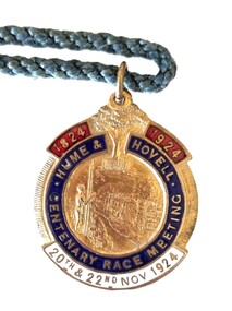
Memorabilia - Hume and Hovell Centenary Race Meeting - Albury
Great celebrations took place in Albury, NSW for the celebration of the Centenary of the Hume and Hovell expedition. The Hume and Hovell journey of discovery to Port Phillip took place during 1824-1825. On November 20, 1824, they successfully crossed the Murray River not far from Albury and proceeded on a route to Port Phillip. To celebrate the Centenary of this crossing, the city of Albury held a series of activities during the week of Sunday 16th November to Saturday 22nd November 1924. As part of these celebrations the Albury Race Club held a special race meeting conducted on Thursday 20th and Saturday 22nd November 1924. This badge was produced as a memorabilia for that meeting. Prize money over the two day meeting totalled over £3,000. The star events were the Centenary Cup of I mile and 3 furlongs with a prize of £1000 (one thousand pounds) and a Gold Cup valued at one hundred guineas, donated by Mrs. Jas. Mitchell of Tabletop, and the John Campbell Handicap of one mile carrying $500 and trophy valued at 50 guineas donated by the chairman of the Club, Mr. J. Campbell. A gold whip donated by Mr. Norman Crow was presented to the jockey riding the Cup winner. This item is significant because it is an example of memorabilia produced for the centenary celebrations for the Hume and Hovell Expedition.An enamelled fob medallion featuring a central image with a tree at the top and text. The tree is the Hovell Tree at Albury. The central image is of indigenous man facing Albury’s civic buildings with the Murray River in between. The fob is attached to a blue twisted cord.1824 1924 HUME & HOVELL CENTENARY RACE MEETING 20th and 22nd Nov 1924 On back: 244B SIMPSONhume & hovell, hume & hovell centenary, albury race club -
 Ballarat Heritage Services
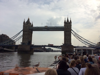
Photograph - Digital photograph, Dorothy Wickham, Tower Bridge, London, 2016, 19/09/2016
It took eight years, five major contractors and the relentless labour of 432 construction workers to build Tower Bridge. Two massive piers were sunk into the river bed to support the construction and over 11,000 tons of steel provided the framework for the Towers and Walkways. This framework was clad in Cornish granite and Portland stone to protect the underlying steelwork and to give the Bridge a more pleasing appearance.(http://www.towerbridge.org.uk/bridge-history/)tower bridge, london -
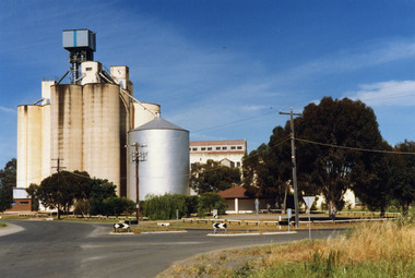 Charlton Golden Grains Museum Inc
Photograph, Charlton Shire, Charlton Flour Mill, c.1987
A previous mill had operated in Charlton by Mr. W.E. Foreman on the banks of the Avoca River and was acquired in 1919 by Noske Bros. The present Flour Mill was built by Noske Bros and opened in May 1927. It was taken over by the Grain Elevator Board in the 1970s. Colour photograph of Charlton Flour Mill and silos. Intersection of Kaye & Davies Streets in the foreground. One large silver silo and three taller greyish concrete silos to the left. Three other cream coloured silos behind. There are pipes and sheds on top of the silos. There is a cream single story building to the right of the silver silo and a multi-storey building behind with eight window in the upper level. There is a small red brick building on the far left of the photo.w.e. foreman, noske bros, flour mill charlton, business, industry -
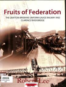 Victorian Railway History Library
Book, Lee, Robert, Fruits of Federation, 2009
... Grafton to Brisbane and the building of the rail/road bridge over ...A history of the railway from Grafton to Brisbane and the building of the rail/road bridge over the Clarence River at Grafton.index, ill, maps, p.166.non-fictionA history of the railway from Grafton to Brisbane and the building of the rail/road bridge over the Clarence River at Grafton.railroad construction - new south wales - history, railroad operations - new south wales - history -
 Wodonga & District Historical Society Inc
Photograph - Bethanga Bridge
The Bethanga Bridge was built between 1927 and 1930 as a joint venture between Victoria and New South Wales and was a key element of the River Murray Waters Agreement. It consists of nine spans of 82 metres long. Each span is supported between double reinforced concrete pylons and a riveted steel camel back Pratt truss. The overall span of the bridge is a length of 752 metres. It was completed in 1929 at a cost of £194,000. The road deck was initially constructed from timber but was replaced in 1961 with a concrete waffle slab deck 7.7metres wide. In 1961 the bridge deck and truss structure were raised 300 millimetres to allow for the enlargement of the lake. The bridge was designed in NSW by road engineer Percy Alan and the trusses were built by the Charles Ruwolt Pty. Ltd. Charles Ruwolt Pty. Ltd. was originally established by Charles Ruwolt as a foundry at Wangaratta in 1902 and transferred its operations to Richmond, Melbourne in 1914. By 1938 it had become one of the biggest engineering companies in Australia. After Charles Ruwolt’s death in 1946, Vickers Ltd. acquired the company and in 1948 the firm became known as Vickers Ruwolt Pty. Ltd. Because of the Bethanga Bridge’s unique location, over the waters of a dam with the border running down the centre of the body of water, the Bethanga Bridge is the only built structure shared by both Victoria and New South Wales. As the border of New South Wales aligns with the southern bank of the Murray River all of the other bridges along its length are deemed to be in New South Wales. The Bethanga Bridge is listed on both the New South Wales State Heritage Register and the Victorian Heritage Database. In 2015 the Bethanga Bridge was nominated for a heritage award by the Institution of Engineering Australia.These images are significant because they document the construction of a bridge which links Victoria and New South Wales and has been recognised for its historical, technical and engineering significance.A collection of photos documenting the construction of the Bethanga Bridge which links the States of Victoria and New South Wales as part of the construction of the Hume Dam .bethanga bridge, hume dam constuction, charles ruwolt, percy allan engineer -
 National Vietnam Veterans Museum (NVVM)
Book, Scholl-Latour, Peter, Death in the Ricefields: Thirty Years of War in Indochina
... , and the view over the Saigon River was blurred by the dark, humid air ...The monsson raid had been falling non-stop since early morning, and the view over the Saigon River was blurred by the dark, humid air.The monsson raid had been falling non-stop since early morning, and the view over the Saigon River was blurred by the dark, humid air.indochina - description and travel, indochina - history - 1945, saigon, dien bien phu, rice fields, ho chi minh -
 Eltham District Historical Society Inc
Photograph, C.S. Wingrove, Secretary, Eltham District Road Board 1858-1871; Shire Secretary, Shire of Eltham 1871-1904, 1858-1871
Charles Symons Wingrove, J.P. (1829-1905) arrived in Victorian in 1851. He had trained as an engineer, but tried his luck on the goldfields. In 1857 he was appointed as Secretary to the Eltham District Roads Board only one year after its foundation. He was to hold the position with the Board and later the Eltham Shire Council for total of 47 years. He also held the position of engineer for a large part of this period. During part of this time he was also secretary to the Heidelberg Shire Council. Over this period he was responsibly for an area stretching from Clifton Hill to Healesville, along the northern bank of the Yarra River. Other positions included Secretary to the Victorian Agricultural Society over along period.Wingrove was a main figure in the Municipal Association of Victoria. By the time he retired he was recognized as the “Grand Old Man” of Victorian local government. In 1858 Wingrove had a brick cottage built in Main Road near the State School and he lived here until his death. One room was uded as the Board and Council office. His descendants owned the house until 1974. It was later used as a psychiatric clinic. The park opposite the cottage has been named Wingrove Park in his honour. He is buried at St Helena with other members of his family. Age (Melbourne, Vic. : 1854 - 1954), Tuesday 18 July 1905, page 5 ABOUT PEOPLE. A conspicuous figure in northern municpal history, Mr. Charles Symons Wingrove, has passed away. He was for many years secretary and engineer for the shire of Eltham, and prior to the formation of the shire held the position under the old road board, his official connection with the district dating from beyond 1857. For about twelve years he also filled the position of shire engineer for Heidelberg council while retaining his other post, and the immense territory under his professional control, reaching from the boundary of Collingwood up to Healesville, was a matter of fatherly pride and interest to him. He arrived in Victoria in 1851, and was 76 years of age at his death. Mr. Wingrove retired from the position in the Eltham council only about a year ago. The interment will take place in St. Helena Cemetery, near Eltham township, today. Secretary, Eltham District Road Board 1858-1871 Secretary for the Shire of Eltham 1871-1904. Nearly 50 years service to the local community. For about twelve years he also filled the position of shire engineer for Heidelberg council. Reproduced Page 137 "Pioneers & Painters" This photo forms part of a collection of photographs gathered by the Shire of Eltham for their centenary project book,"Pioneers and Painters: 100 years of the Shire of Eltham" by Alan Marshall (1971). The collection of over 500 images is held in partnership between Eltham District Historical Society and Yarra Plenty Regional Library (Eltham Library) and is now formally known as the 'The Shire of Eltham Pioneers Photograph Collection.' It is significant in being the first community sourced collection representing the places and people of the Shire's first one hundred years.Digital image Print 25 x 20 cmc.s.wingrove, charles symons wingrove, eltham district road board, sepp, shire of eltham pioneers photograph collection, shire secretary, wingrove cottage, pioneers and painters, shire of eltham, councilor, municipal officer -
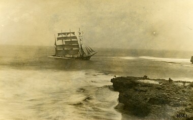 Flagstaff Hill Maritime Museum and Village
Postcard - Local Postcards, Joseph Jordan Photographic Studio, Nov 1908 - early 1909
ABOUT THE ‘FALLS OF HALLADALE’ (1886 - 1908) Built: in1886 by Russell & Co., Greenock shipyards, River Clyde, Scotland, UK. The company was founded in 1870 (or 1873) as a partnership between Joseph Russell (1834-1917), Anderson Rodger and William Todd Lithgow. During the period 1882-92 Russell & Co., they standardised designs, which sped up their building process so much that they were able to build 271 ships over that time. In 1886 they introduced a 3000 ton class of sailing vessel with auxiliary engines and brace halyard winches. In 1890 they broke the world output record. Owner: Falls Line, Wright, Breakenridge & Co, 111 Union Street, Glasgow, Scotland. Configuration: Four masted sailing ship; iron-hulled barque; iron masts, wire rigging, fore & aft lifting bridges. Size: Length 83.87m x Breadth 12.6m x Depth 7.23m, Gross tonnage 2085 ton Wrecked: the night of 14th November 1908, Curdies Inlet, Peterborough southwest Victoria Crew: 29 The Falls of Halladale was a four-masted sailing ship built-in 1886 in Glasgow, Scotland, for the long-distance cargo trade and was mostly used for Pacific grain trade. She was owned by Wright, Breakenridge & Co of Glasgow and was one of several Falls Line ships, all of which were named after waterfalls in Scotland. The lines flag was of red, blue and white vertical stripes. The Falls of Halladale had a sturdy construction built to carry maximum cargo and able to maintain full sail in heavy gales, one of the last of the ‘windjammers’ that sailed the Trade Route. She and her sister ship, the Falls of Garry, were the first ships in the world to include fore and aft lifting bridges. Previous to this, heavily loaded vessels could have heavy seas break along the full length of the deck, causing serious injury or even death to those on deck. The new, raised catwalk-type decking allowed the crew to move above the deck stormy conditions. This idea is still used today in the most modern tankers and cargo vessels and has proved to be an important step forward in the safety of men at sea. On 4th August 1908, with new sails, 29 crew, and 2800 tons of cargo, the Falls of Halladale left New York, bound for Melbourne and Sydney via the Cape of Good Hope. The cargo on board was valued at £35,000 and included 56,763 tiles of American slate roofing tiles (roof slates), 5,673 coils of barbed wire, 600 stoves, 500 sewing machines, 6,500 gallons of oil, 14,400 gallons of benzene, plumbing iron, 117 cases of crockery and glassware and many other manufactured items. The Falls of Halladale had been at sail for 102 days when, at 3 am on the night of 14th November 1908, under full sail in calm seas with a six knots breeze behind and misleading fog along the coast, the great vessel rose upon an ocean swell and settled on top of a submerged reef near Peterborough on south-west Victoria’s coast. The ship was jammed on the rocks and began filling with water. The crew launched the two lifeboats and all 29 crew landed safely on the beach over 4 miles away at the Bay of Islands. The postmistress at Peterborough, who kept a watch for vessels in distress, saw the stranding and sent out an alert to the local people. A rescue party went to the aid of the sailors and the Port Campbell rocket crew was dispatched, but the crew had all managed to reach shore safely by the time help arrived. The ship stayed in full sail on the rocky shelf for nearly two months, attracting hundreds of sightseers who watched her slowly disintegrate until the pounding seas and dynamiting by salvagers finally broke her back, and her remains disappeared back into deeper water. The valuable cargo was largely lost, despite two salvage attempts in 1908-09 and 1910. Further salvage operations were made from 1974-1986, during which time 22,000 slate tiles were recovered with the help of 14 oil drums to float them, plus personal artefacts, ship fittings, reams of paper and other items. The Court of Marine Inquiry in Melbourne ruled that the foundering of the ship was entirely due to Captain David Wood Thomson’s navigational error, not too technical failure of the Clyde-built ship. The shipwreck is a popular site for divers, about 300m offshore and in 3 – 15m of water. Some of the original cargo can be seen at the site, including pieces of roof slate and coils of barbed wire. These 5 postcards have photographic images taken while the Falls of Halladale was stuck on the reef near Peterborough. They are not stamped or dated but four of the images show the ship still in fairly good condition with her stern very low in the water so can be dated to around late November 1908 to January 1909 and the fifth image shows the ship beginning to disintegrate soon after. The image on Postcard 8658.3 was taken by Joseph Jordan (a well-known Warrnambool photographer who had his own studio in Liebig Street, Warrnambool). The other four images were supposedly taken by the sender (Bob) and converted to postcards. Amateur photography in Australia in the early 1900's was becoming very popular (and accessible) to the average person. Many newspapers published advertisements and articles about photography and photographic supplies. In 1903 in America, George Eastman designed and marketed the "Model 3A Folding Pocket Kodak" which used postcard-size negatives and provided the average person with a camera with which to make real photo postcards. As they became popular, George Eastman was able to develop and market a wide range of supplies for the amateur photographer to develop and print their own photographs onto a postcard backing at home. Four of the postcards were addressed to "Miss M. Kerr, Leura, Camperdown". Mary Agnes Kerr (1888 - 1943) was the daughter of William and Mary Ann Kerr (nee Spence) who owned "Leura Farm" at Camperdown. Mary Agnes Kerr went on to marry James Young Caldwell (a local tailor and mercer) in 1917. James Yong Caldwell came to Camperdown around 1908 and was employed as a draper. The postcards were signed "Bob". On postcard 5658.2 he has written his name with quotation marks around it - suggesting "Bob" is a nickname. He writes about the weather, meeting a friend, sending fish to Mary Agnes' family and the cargo expected to be washed up on the beach. On postcard 8658.4 he wrote about being busy after the wreck and supplying the shipwrecked crew with boots and pants which suggests "Bob" may be James Caldwell (the mercer and tailor).The Falls of Halladale shipwreck is listed on the Victorian Heritage Register (No. S255). She was one of the last ships to sail the Trade Routes. She is one of the first vessels to have fore and aft lifting bridges. She is an example of the remains of an International Cargo Ship and also represents aspects of Victoria’s shipping industry. The wreck is protected as a Historic Shipwreck under the Commonwealth Historic Shipwrecks Act (1976). These postcards are significant as examples of the continued interest the locals around the district of Peterborough showed towards the Falls of Halladale wreck and its disintegration during the next few months. Four of the postcards are also significant examples of the new hobby of photography that was available to the average person during the beginning of the 20th century.Set of 5 postcards showing different images of the Falls of Halladale sailing ship after it became stuck on a reef near Peterborough. None of the postcards are dated or stamped. Postcard 8658.1 has a sepia toned image of the Falls of Halladale, with its stern sitting very low in the water. It has many of its sails unfurled and there is a rocky headland in the foreground. A very small figure appears to be on the edge of the cliff. The back of the postcard has a handwritten message addressed to "Miss M Kerr, Leura, Camperdown" and is signed "Love Bob". Postcard 8658.2 has a sepia image of the Falls of Halladale taken some months after it had been stuck on the reef. Its sails are missing and only two broken masts remain. A large rock is visible in the front right hand side of the photo. There is a handwritten message on the back signed by "Bob". Postcard 8658.3 has a black and white image of the Falls of Halladale showing her almost side on with her stern very low in the water and still in full sail. The words "Falls of Halladale. No 1" are printed on the lower left side of the image. The back is labelled "Jordan Series". There is no message written on the back. Postcard 8658.4 has a sepia toned image of the Falls of Halladale facing two rocky headlands. She is showing full sail and the sea appears calm. There is a handwritten note on the back addressed to "Miss M Kerr" from "Bob". Postcard 8658.5 has a sepia image of a side view of the Falls of Halladale with her stern very low in the water and her sails are all up. The sea is calm and a rocky reef can be seen in the foreground. It has a handwritten note on the back from "Bob" to "Miss M Kerr" of Leura, Camperdown.Back of postcard 8658.1- "POST" "EMPIRE" "CARD" "FOR CORRESPONDENCE" "FOR ADDRESS ONLY" "STAMP" "Miss M Kerr / Leura / Camperdown" "Looking forward to letter today" "Hope fish arrived / allright. Don't / know for sure / what day I will / be going to Town / to buy. Some day / this week / Love Bob Back of postcard 8658.2 - "POST CARD"/ "CORRESPONDENCE" "ADDRESS ONLY" "93"/ "Friday / This is a contrast to the first/ I sent you. Having glorious weather / Saw Saw (Saul)? on Thursday at Peterborough / He is having a grand holiday / Expecting letter on /Tuesday Fondest Love / "Bob" Front of postcard 8658.3 - "Falls of Halladale. No 1" Back of postcard 8658.3 -"Post" "Card"/ Printed in Great Britain" /"This space may be used for Communication" "The Address to be written / here" "Jordan Series" Back of postcard 8658.4 -"POST" "EMPIRE" "CARD"/ "FOR CORRESPONDENCE" "FOR ADDRESS ONLY" / "STAMP" "Miss M Kerr/ Leura / Camperdown"/ "We are/ very busy. The / wreck is about / 11/2 other side of / Peterborough./ Fondest Love, Bob "Had to supply sailors with Boots Pants etc/ 25 pairs Boots, good order ah!" Back of postcard 8658.5 - "POST" "EMPIRE" "CARD" / "FOR CORRESPONDENCE" "FOR ADDRESS ONLY" / "STAMP"/ "Miss M Kerr / Leura / Camperdown" "Tuesday / Her estimated / value cargo included/ is (pounds)100,000. When / she breaks up the coast / will be strewn with / wreckage as the cargo / includes Rolls Paper./all sorts machinery thousands / cases Benzine etc/ love Bob flagstaff hill maritime museum and village, warrnambool, peterborough, great ocean road, falls of halladale, shipwreck, postcards, photographic images, mary agnes kerr, leura farm, camperdown, jordan series, handwritten notes, photographs, george eastman, 3a folding pocket kodak camera -
 Eltham District Historical Society Inc
Photograph - Digital Photograph, Alan King, Stonygrad, 34 Hamilton Road, North Warrandyte, 30 January 2008
Vassilieff dynamited rock from his own property to build his house. Stonygrad is reminiscent of a grotto and in parts, of a sculpture. Covered under Heritage Overlay, Nillumbik Planning Scheme. Published: Nillumbik Now and Then / Marguerite Marshall 2008; photographs Alan King with Marguerite Marshall.; p135 Stonygrad, the home built by Expressionist painter and sculptor Danila Vassilieff, is reminiscent of a grotto and in parts, of a sculpture. Vassilieff, who amongst others influenced painter Sydney Nolan and Albert Tucker, was a member of the artists group the Angry Penguins. He was also a highly regarded art teacher at the nearby Koornong Experimental School and taught at Eltham High School. Art critic Robert Hughes described Vassilieff’s painting as ‘lyrical without social commentary’, and said Vassilieff was ‘the most oddly neglected artist in recent Australian History’. Vassilieff, who was born in 1897 in Russia, had an unusually adventurous life before he settled in Warrandyte. The 12th of 18 children, he lived on a farm in the Don Basin. Vassilieff trained with the Imperial Military Academy at St Petersburg and fought in World War One as an officer in the White Russian Army against the communists. In 1920 he was captured, then escaped from prison, stole a horse and rode bareback 150 miles to the Black Sea, helped at first by Tartar freebooters. He then travelled to India, Shanghai and arrived in Queensland as a refugee in 1923 where he began painting. He and his wife Anisia bought a sugar farm near Ingram, and later he constructed railway lines at Mataranka, in the Northern Territory.4 In 1929 Vassilieff went to Brazil for formal art training from former fellow-officer Dmitri Ismailovich, but he soon left to travel up the Amazon River. He then worked as a sidewalk artist in the West Indies and travelled for two years in England, France and Spain. In 1937 he arrived in Melbourne where he lived until his death in 1958. His first major Australian series was the Carlton streetscapes and from 1951 he sculpted in local hard limestone. Vassilieff rejected all dogma and regarded religious subjects as suitable only for decorative arts. In 1944 he helped defeat a communist attempt to take over the Contemporary Art Society. For a short time, from around 1955, Vassilieff taught at various Victorian schools. The Angry Penguins painted mainly between 1937 and 1947, and included Arthur Boyd, Albert Tucker, Sidney Nolan and Joy Hester. The group formed as they felt isolated from European thought and art (including Surrealism) from which their work was derived. They were also angry at what they considered to be the complacency and insularity of their society. They maintained Australians at first were scarcely aware of the threats of the Wall Street Crash and Hitler and were little interested in the Spanish Civil War. The Angry Penguins also objected to the White Australia Policy. Hughes said although most of the Melbourne Expressionists in the 1940s were unskilled and their work crude in style, they helped jolt Australian painting from its pastoral complacency. Their style influenced nearly every painting produced by significant figurative artists in Melbourne in the 1950s such as Charles Blackman. From 1939 Vassilieff built Stonygrad, mainly with local stone. The house stands at the end of a private road surrounded by trees with the quiet occasionally broken by the sounds of bellbirds. To build his house Vassilieff dynamited rock and cut trees from his own property. The original section of the three-level house is of irregular-shaped pieces of solid stone, exposed inside like the exterior. Vassilieff later built sections with timber and brick. Inside is rustic and cave-like, and several rooms are linked by arched openings with no doors. One undulating wall was carved out of rock from which two sculptured heads protrude. Several ceilings are of rough-hewn logs and the built-in table and bookcase are rough, as is a timber ladder leading to a bedroom. Not for the elderly or unsteady! Yet the general impression in the muted light is beautiful, with artistic originality.This collection of almost 130 photos about places and people within the Shire of Nillumbik, an urban and rural municipality in Melbourne's north, contributes to an understanding of the history of the Shire. Published in 2008 immediately prior to the Black Saturday bushfires of February 7, 2009, it documents sites that were impacted, and in some cases destroyed by the fires. It includes photographs taken especially for the publication, creating a unique time capsule representing the Shire in the early 21st century. It remains the most recent comprehenesive publication devoted to the Shire's history connecting local residents to the past. nillumbik now and then (marshall-king) collection, danila vassilieff, hamilton road, north warrandyte, stonygrad -
 Falls Creek Historical Society
Photograph - Jack Maddison Leading horses on the Bogong High Plain
The images in the Bogong Village Collection were displayed in Bogong Jack’s Tavern for over 20 years and were donated to the Falls Creek Museum when the Tavern closed in 2021. In 1939, the State Electricity Commission of Victoria established a field headquarters at Bogong to house workers and their families for the Kiewa Hydroelectric Scheme which ran from the 1930s to the 1960s. The workmen's camp was originally started with tents and was called Junction Camp. By 1947, the village supported 300 workers and their families. It included 40 houses, a hostel for single staff, a post office, a police station, a medical centre, and a primary school. The staff hostel was known as Kiewa House. At the completion of the Scheme, in the 1960s, the village was opened to public/tourism use. In 1968 the Victorian Education Department acquired the camp buildings and four houses from the State Electricity Commission of Victoria to establish an Outdoor Education Centre which operated for over 50 years. The Kiewa Hydroelectric Scheme was privatized in the 1990s and sold to Southern Hydro, before being acquired by AGL in 2005. In 2023 the Grollo Group signed a 73 year sublease on Bogong Village and has plans for its redevelopment as a workers’ village. John Maddison and his wife Mary Padman emigrated from London to Australia in 1850 with their five sons. Jack (John James William Maddison) was one of their great grandsons. In 1877 Jack’s grandfather George Maddison selected land between the East and West Kiewa branches of the Kiewa River - known as the "Island". It is now known as Mount Beauty. The Maddison family built Aertex Hut at the top of T Spur at Mt. Bogong for use when grazing cattle. It later became known as Maddison's Hut. Staircase Spur walking track at Bogong was formerly known as Maddison’s Track as it is the path once used by the Maddison family to drive their cattle on to the high plains. These images are significant because they feature the son of a pioneering family on the Bogong High Plains.A black and white photograph of Jack Maddison leading horses on the Bogong High Plains.bogong alpine village, bogong high plains, maddison family mt beauty, maddison's hut, aertex hut, -
 Eltham District Historical Society Inc
Photograph - Digital Photograph, Alan King, Nillumbik Shire Offices, Greensborough, 30 March 2008
Nillumbik Shire Council transferred to the former Diamond Valley Shire Offices in Greensborough after municipal restructuing. The offices became the official Nillumbik Shire Council Offices on 16 October 1995. The former Shire of Diamond Valley Civic Centre or Shire Office building was officially opened on 26th February 1972. Archtiects were A.K. Lines, McFarlane & Marshall and it was built by L.U. Simon Pty Ltd, The Diamond Valley Shire had been created in 1964 from part of the City of Heidelberg. On December 15, 1994 the Shire of Nillumbik was established. Under the Council amalgamations imposed by the Kennett government, the Shire of Eltham, Shire of Diamond Valley and City of Heidelberg ceased to exist with the establishment of Nillumbik Shire Council and the City of Banyule.The new Nillumbik shire surrended the west riding from Eltham to Banyule but in place gained parts of the former Diamond Valley Shire which itself had been created in 1964 from parts of the City of Heidelberg. Three unelected and non-local Commissioners were put in place by the government bringing democracy into question by many members of the local community. The Commissioners determined to abandon the former Shire of Eltham offices located in Main Road, Eltham and in turn occupy the former Shire of Diamond Valley offices located at the boundary of the new shire with Banyule, in Civic Drive, Greensborough. In July 1996 the Commissioners sold the former Eltham Shire Offices and had them bulldozed leading to many years of communiity protest over the process and future development applications. The site has remained vacant ever since. Published: Nillumbik Now and Then / Marguerite Marshall 2008; photographs Alan King with Marguerite Marshall.; p43 It was the need for roads that led to this district’s first council. In 1853 a committee was formed to improve the rough roads, some in Kangaroo Ground being almost impassable in winter.1 The committee fundraised by voluntary levies and grants to improve in particular, the main road between Kangaroo Ground and the Plenty River. From this committee arose the Eltham District Road Board, in 1856, which was the precursor to the Eltham Shire Council. The Board’s first chairman was Kangaroo Ground farmer, John Barr. Secretary was the former committee’s secretary, Andrew Ross, Kangaroo Ground’s first school teacher, and founder of the district newspaper, The Evelyn Observer.2 Most of the board’s income came from a toll-house north of the Lower Plenty Bridge, which funded such projects as a road from Kangaroo Ground to the Caledonia Diggings. In 1871 the Shire of Eltham was proclaimed, with its boundaries the same as those of the Road Board, and Councillor A Donaldson of Kangaroo Ground was the first president. Eltham was at the southern tip of the shire, which extended north to Kinglake and east beyond Yarra Glen. In 1878, part of Kinglake was added to the shire, while the area east of Watts River, near Healesville was removed. In 1912, then again in 1958, the shire was further reduced. Yarra Glen, Steels Creek, Tarrawarra, parts of Healesville and Christmas Hills, were transferred to the Shire of Healesville. In 1972 a smaller area, at Kinglake, was transferred to the Shire of Yea, leaving 277 square kilometres in the Eltham Shire. Perhaps no other Victorian municipality has had so many meeting places. Although from 1858 to 1904, the council convened at the office in the home of Secretary Charles Wingrove, the board, and later the council, also met at other more central locations.3 The board moved from the Fountain of Friendship Hotel to the Eltham Courthouse, to the Kangaroo Ground schoolhouse. It then met at the Kangaroo Ground Hotel, which some considered put it in danger of interruptions by people ‘the worse for liquor’.4 In 1885 the council met at the hall on Mr J Donaldson’s land at Kangaroo Ground. After Wingrove’s retirement, the council rented space at the Kangaroo Ground General Store and Post Office. Then, in 1917, the council bought the former office of The Evelyn Observer, after its printing works transferred to Hurstbridge. In 1934, fire destroyed the shire office, which was temporarily relocated to the Kangaroo Ground home of Shire Secretary, Mr P J McMahon. In 1941, the shire office moved to a new building (which included a public hall) in Eltham, at the corner of Arthur Street and Main Road, where the Eltham Village Shopping Centre was eventually built. Growth required new offices, which opened in 1965, on the former Shillinglaw property in Main Road.5 In 1994, as part of municipal restructuring under the Jeff Kennett Liberal Government, most of the Eltham Shire formed part of the new Shire of Nillumbik. It joined with the north section of the Diamond Valley Shire and parts of the Healesville and Whittlesea municipalities. The Diamond Valley Shire had been created in 1964, from part of the City of Heidelberg. Turbulence followed Nillumbik Shire’s formation. Under the Commissioners the council transferred to the former Diamond Valley Shire offices in Greensborough, and the Eltham council offices were demolished. In March 1997 the first five-member Nillumbik Council was elected. But, in October 1998, the government suspended the council and appointed an administrator . Early in 1999, shire residents voted to increase councillors to nine: comprising five ward councillors and four shire-wide councillors. Elections were held in March 1999. Then, before the March 2002 elections, nine new wards were created.6 In 2008 these were reduced to seven. Today [2008] the council governs a varied population of more than 60,000 people living in townships and on bush properties in the green wedge.This collection of almost 130 photos about places and people within the Shire of Nillumbik, an urban and rural municipality in Melbourne's north, contributes to an understanding of the history of the Shire. Published in 2008 immediately prior to the Black Saturday bushfires of February 7, 2009, it documents sites that were impacted, and in some cases destroyed by the fires. It includes photographs taken especially for the publication, creating a unique time capsule representing the Shire in the early 21st century. It remains the most recent comprehenesive publication devoted to the Shire's history connecting local residents to the past. nillumbik now and then (marshall-king) collection, greensborough, nillumbik shire council offices, civic drive -
 Eltham District Historical Society Inc
Photograph - Digital Photograph, Marguerite Marshall, Smith Dam, Karingal Drive, Eltham, 19 September 2006
The dam at the entrance to the Nerreman Gateway in Eltham was built according to an internationally acclaimed theory developed by the builder's father. In 1920, Victorian engineer B.A. Smith was awarded the American Society of Civil Engineers J. James R. Cross Gold Medal for his Technical Paper titled 'Arched Dams'. It was the first time this medal had been awarded outside the United States. The concrete arched dam across the Eltham West Drain was built in 1940 by B.A. Smith's son and engineer, D. B. (Bernie) Smith to water the 24 acre (9.75 ha) hobby farm owned by himself and new wife, Isa Smith. Upon completion of the dam a pump-house was constructed beside the creek but before the water could be pumped up the hill they had to dig a trench and lay 500m of 100mm water main to an elevated holding tank. The Smiths made the pump-house their home for several years until they constructed their home at the top of the hill overlooking Eltham and views extending to Kinglake. Following Bernie's death in 1983, Nerreman Park was subdivided between 1993 and 1995. Gordon Ford designed the landscaping and the pump-house was demolished. Covered under Heritage Overlay, Nillumbik Planning Scheme. Published: Nillumbik Now and Then / Marguerite Marshall 2008; photographs Alan King with Marguerite Marshall.; p137 The dam at the entrance to the Nerreman Gateway in Eltham, was built according to an internationally acclaimed theory developed by the builder’s father. In 1920, Victorian engineer B A Smith was awarded the American Society of Civil Engineers J. James R. Croes Gold Medal, for his Technical Paper titled Arched Dams. It was the first time this medal had been awarded outside America. An international example of the application of Smith’s work can be found in the design of the Hoover Dam on the Colorado River, Nevada, USA. Built between 1930 and 1936, it is recognised by the ASCE as one of ‘America’s Seven Modern Civil Engineering Wonders’.1 The concrete arched dam across the Eltham West Drain was built by B A Smith’s son and engineer, D B (Bernie) Smith. Bernie’s dam followed his father’s theory, having a curvature that takes maximum advantage of concrete’s great strength in compression. The water load is carried into the abutments because of this curvature, which permits a wall thickness of only 225 millimetres thick at its crest, despite the dam’s capacity of more than 4.5 megalitres. The Eltham dam was designed to water the 24 acre (9.75 ha) hobby farm belonging to newly married couple Bernie and Isa Smith. Bernie, from Armadale, and Isa, from a farm at Tyntynder near Swan Hill, were attracted to the hilly topography and the creek running through the property. It extended from Ryans Road, Eltham, to Karingal Drive, Montmorency and was adjacent to Meruka Park. The Smiths named it Nerreman Park using the Aboriginal word Nerreman meaning ‘River Bend’ as their creek had a pronounced bend.2 In 1940 the first thing Bernie did was to build a dam, and with Isa’s help, a pump-house, to secure a water supply for their cattle, pigs, chickens, orchard and vegetable gardens. It was also available for the fire-plugs, which they placed all over the property in case of bushfire. The couple built the pump-house beside the creek and installed a Tange three-plunger pump, which had originally supplied the City of Wodonga with water. But before the Smiths could pump water up the hill from the dam they had to dig a trench and lay about 550 yards (500m) of a four-inch (100mm) water main up to an elevated holding tank. The trench was dug with a single furrow plough drawn by an old draught horse. Living in rough conditions did not deter the Smiths, who made the pump-house their home, where they still lived when their first child was born in 1944. They later built their home at the top of their property overlooking Eltham, with magnificent views to Kinglake, the Dandenong Ranges and Melbourne. From 1946 it took them almost 20 years to complete the 36-square house with its 12-foot (3.6m) high ceilings. Material for the concrete roof and walls faced with sandstone, was ripped out of the ground on their property by plough pulled by tandem Clydesdale horses. Isa was a strong woman – two days before their second child was born – she set three huge sandstone boulders in place in the bottom wall of the garage. She also mixed all the cement for the house. A collapsed kitchen wall did not discourage her from rebuilding it in a week, while her husband was away working in the country. She later recalled: ‘We stood back to admire this beautiful wall we’d built and while we were looking at it, it came tumbling down’.3 Following Bernie’s death in 1983, Nerreman Park was subdivided, between 1993 and 1995. Local Gordon Ford designed the landscaping and the pump-house was pulled down. But the dam remains as a reminder of exceptional engineering4 – and of a remarkable couple.This collection of almost 130 photos about places and people within the Shire of Nillumbik, an urban and rural municipality in Melbourne's north, contributes to an understanding of the history of the Shire. Published in 2008 immediately prior to the Black Saturday bushfires of February 7, 2009, it documents sites that were impacted, and in some cases destroyed by the fires. It includes photographs taken especially for the publication, creating a unique time capsule representing the Shire in the early 21st century. It remains the most recent comprehenesive publication devoted to the Shire's history connecting local residents to the past. nillumbik now and then (marshall-king) collection, eltham, karingal drive, smiths dam, bernie smith, gordon ford, isa smith, nerreman gateway, nerreman park estate, dams -
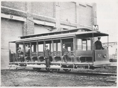 Melbourne Tram Museum
Photograph - Black and White V class 215 at Preston Workshops 1925
Tram originally built for The North Melbourne Electric Tramways and Lighting Co. (NMETL) in 1906 as a straight sill open cross bench tram. Photograph is of the tram body on an un-motored truck or wheel set and has been posed for an official MMTB photograph in 1925, soon after the workshops were completed. It shows the destination of "M River" for Maribyrnong River.Shows the only type of fully open cross bench tram operated by the MMTB. This style was popular as a summer tram in North America. Originally built by Brill (USA) in 1906 and assembled by Duncan and Fraser for the NMETL as Tram No. 14. Taken over by the MMTB in 1922 and given the number 215.Black and White photograph of V class 215 at Preston Workshops 1925.In ink on rear "V class"trams, tramways, v class, preston workshops, tram 215, nmetl, brill, mmtb, uniforms -
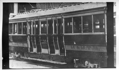 Melbourne Tram Museum
Photograph - Black and White Photos - MMTB P Class Tram 136 at Hawthorn, pre May 1925
Photo shows one of the Maximum Traction Bogies trams built for the Hawthorn Tramways Trust by Duncan and Fraser of Adelaide in 1917-1918. Photographed in the Hawthorn Depot some time before May 1925. This tram began its life as HTT No. 30. The body was sold in 1944. The full photo appears on page 17 of Tramway by the River.Yields information about early liveries of MMTB ex HTT bogie trams.Two photos of former HTT bogie tram No. 136 at Hawthorn Depot before May 1925. On rear of photo 1, it is noted that the paintwork was that before May 1925. Other notations (1) Long piece of barrier rail along drop centre (2) Monogram (HTT) on saloon doors (3) Triple railings over bulkhead windows (4) Cylindrical destination box (on rear). Notes on photo 2, (1) paintwork was that before May 1925 (2) Route No D (3) Monogram (HTT) on saloon door (4) Triple railings over bulkhead window (5) Old destination box (6) Iron gates.See notes above.tramways, trams, hawthorn depot, tram 136, mmtb, htt, p class, route d -
 Bendigo Historical Society Inc.
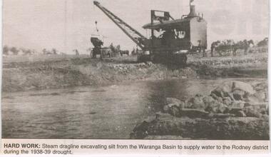
Newspaper - JENNY FOLEY COLLECTION: HARD WORK
Construction of the Waranga Basin initially took place 1905-1915 when it was dug by pick, shovel and horse-drawn scoops. It's embankment was initially 29ft high but over time this was increased to 40 ft. It is an off-river dam that is fed by diversion of water from the Goulbourn River and its aim is to provided irrigation water.Bendigo Advertiser ''The way we were'' from 2003. Hard work: steam dragline excavating silt from the Waranga Basin to supply water to the Rodney district during the 1938-39 drought. The clip is in a folder.newspaper, bendigo advertiser, the way we were -
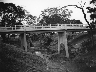 Stawell Historical Society Inc
Photograph, Greens Creek Bridge on the Wimmera River 1929
Greens Creek Bridge on the Wimmera River built in 1929 by C.R.B. and now demolished. The replacement bridge was designed to cope with the floods and the approaches to the new bridge were built up. This photo is a copy of a negative owned by the society.Black and white photograph of a concrete road bridge over a creek. Red gum trees in the background. Two concrete supports remain of old bridge on bank behind new bridge.stawell