Showing 1028 items matching "water river"
-
 Eltham District Historical Society Inc
Photograph - Digital Photograph, Alan King, Blue Lake, Plenty Gorge Park, 2008
A quarry was transformed into the Blue Lake. Published: Nillumbik Now and Then / Marguerite Marshall 2008; photographs Alan King with Marguerite Marshall.; p179 The dramatic steep-sided Plenty Gorge lies along the divide of two geological areas, and separates the Nillumbik Shire and the City of Whittlesea. On the Nillumbik side are undulating hills and sedimentary rock, and in Whittlesea, lies a basalt plain formed by volcanic action up to two million years ago. This provides the Plenty Gorge Park with diverse vegetation and habitats, making it one of Greater Melbourne’s most important refuges for threatened and significant species. The park, established in 1986, consists of around 1350 hectares, and extends 11 kilometres along the Plenty River, from Greensborough to Mernda. It provides a wildlife corridor for around 500 native plant and 280 animal species. The area’s plentiful food and water attracted the Wurundjeri Aboriginal people and then European settlers. By 1837 squatters had claimed large runs of land for their sheep and cattle. The Plenty Valley was among the first in the Port Phillip District to be settled - mainly in the less heavily timbered west - and was proclaimed a settled district in 1841.But by the late 1880s, the settlers’ extensive land clearing for animal grazing, then agriculture, depleted the Wurundjeri’s traditional food sources, which helped to drive them away. Many Wurundjeri artefacts remain (now government protected), and so far 57 sites have been identified in the park, including scarred trees, burial areas and stone artefacts. Pioneer life could be very hard because of isolation, flooding, bushfires and bushrangers. Following the Black Thursday bushfires of 1851, basalt was quarried to build more fire-resistant homes. Gold discoveries in the early 1850s swelled the population, particularly around Smugglers Gully; but food production made more of an impact. In the late 1850s wheat production supplanted grazing. In the 1860s the government made small holdings available to poorer settlers. These had the greatest effect on the district, particularly in Doreen and Yarrambat, where orchards were established from the 1880s to 1914. Links with a prominent early family are the remains of Stuchbery Farm, by the river’s edge bounded by Smugglers Gully to the north and La Trobe Road, Yarrambat, to the east. The Stuchberys moved to the valley in 1890, and the family still lives in the area. In 1890, Alfred and Ada first lived in a tent where four children were born, then Alfred built the house and outbuildings around 1896. They planted an orchard, then a market garden, and developed a dairy. The family belonged to the local Methodist and tennis communities. Their grandson Walter, opened the Flying Scotsman Model Railway Museum in Yarrambat, which his widow, Vi, continues to run. Wal was also the Yarrambat CFA Captain for 22 years until 1987. Walter sold 24 hectares in 1976 for development - now Vista Court - and in 1990, the remaining 22.6 hectares for the park. Remaining are an early stone dairy and remnants of a stone barn, a pig sty and a well. Until it was destroyed by fire in 2003, a slab hut stood on the Happy Hollow Farm site, at the southern end of the park. The hut is thought to have been built in the Depression around 1893. This was a rare and late example of a slab hut with a domestic orchard close to Melbourne. Emmet Watmough and his family first occupied the hut, followed by a succession of families, until the Bell family bought it around 1948. There they led a subsistence lifestyle for 50 years, despite encroaching Melbourne suburbia. The Yellow Gum Recreation Area includes the Blue Lake, coloured turquoise at certain times of the year. Following the 1957 bushfires, this area was quarried by Reid Quarries Pty Ltd for Melbourne’s first skyscrapers, then by Boral Australia. However in the early 1970s water began seeping into the quarry forming the Blue Lake and the quarry was closed. The State Government bought the site in 1997 and opened it as a park in 1999.This collection of almost 130 photos about places and people within the Shire of Nillumbik, an urban and rural municipality in Melbourne's north, contributes to an understanding of the history of the Shire. Published in 2008 immediately prior to the Black Saturday bushfires of February 7, 2009, it documents sites that were impacted, and in some cases destroyed by the fires. It includes photographs taken especially for the publication, creating a unique time capsule representing the Shire in the early 21st century. It remains the most recent comprehenesive publication devoted to the Shire's history connecting local residents to the past. nillumbik now and then (marshall-king) collection, blue lake, plenty gorge park -
 Eltham District Historical Society Inc
Photograph - Digital Photograph, Marguerite Marshall, Stuchbery Farm dairy, 14 March 2008
Stuchbery Farm was situated on the Plenty River bounded by Smugglers Gully to the north and La trobe Road, Yarrambat, to the east. Alan and Ada Stutchbery moved to the valley in 1890, first living in a tent where four children were born. Alfred built a home and outbuildings around 1896. They planted an orchard, then a market garden and developed a dairy. Published: Nillumbik Now and Then / Marguerite Marshall 2008; photographs Alan King with Marguerite Marshall.; p179 The dramatic steep-sided Plenty Gorge lies along the divide of two geological areas, and separates the Nillumbik Shire and the City of Whittlesea. On the Nillumbik side are undulating hills and sedimentary rock, and in Whittlesea, lies a basalt plain formed by volcanic action up to two million years ago. This provides the Plenty Gorge Park with diverse vegetation and habitats, making it one of Greater Melbourne’s most important refuges for threatened and significant species. The park, established in 1986, consists of around 1350 hectares, and extends 11 kilometres along the Plenty River, from Greensborough to Mernda. It provides a wildlife corridor for around 500 native plant and 280 animal species. The area’s plentiful food and water attracted the Wurundjeri Aboriginal people and then European settlers. By 1837 squatters had claimed large runs of land for their sheep and cattle. The Plenty Valley was among the first in the Port Phillip District to be settled - mainly in the less heavily timbered west - and was proclaimed a settled district in 1841. But by the late 1880s, the settlers’ extensive land clearing for animal grazing, then agriculture, depleted the Wurundjeri’s traditional food sources, which helped to drive them away. Many Wurundjeri artefacts remain (now government protected), and so far 57 sites have been identified in the park, including scarred trees, burial areas and stone artefacts. Pioneer life could be very hard because of isolation, flooding, bushfires and bushrangers. Following the Black Thursday bushfires of 1851, basalt was quarried to build more fire-resistant homes. Gold discoveries in the early 1850s swelled the population, particularly around Smugglers Gully; but food production made more of an impact. In the late 1850s wheat production supplanted grazing. In the 1860s the government made small holdings available to poorer settlers. These had the greatest effect on the district, particularly in Doreen and Yarrambat, where orchards were established from the 1880s to 1914. Links with a prominent early family are the remains of Stuchbery Farm, by the river’s edge bounded by Smugglers Gully to the north and La Trobe Road, Yarrambat, to the east. The Stuchberys moved to the valley in 1890, and the family still lives in the area. In 1890, Alfred and Ada first lived in a tent where four children were born, then Alfred built the house and outbuildings around 1896. They planted an orchard, then a market garden, and developed a dairy. The family belonged to the local Methodist and tennis communities. Their grandson Walter, opened the Flying Scotsman Model Railway Museum in Yarrambat, which his widow, Vi, continues to run. Wal was also the Yarrambat CFA Captain for 22 years until 1987. Walter sold 24 hectares in 1976 for development - now Vista Court - and in 1990, the remaining 22.6 hectares for the park. Remaining are an early stone dairy and remnants of a stone barn, a pig sty and a well. Until it was destroyed by fire in 2003, a slab hut stood on the Happy Hollow Farm site, at the southern end of the park. The hut is thought to have been built in the Depression around 1893. This was a rare and late example of a slab hut with a domestic orchard close to Melbourne. Emmet Watmough and his family first occupied the hut, followed by a succession of families, until the Bell family bought it around 1948. There they led a subsistence lifestyle for 50 years, despite encroaching Melbourne suburbia. The Yellow Gum Recreation Area includes the Blue Lake, coloured turquoise at certain times of the year. Following the 1957 bushfires, this area was quarried by Reid Quarries Pty Ltd for Melbourne’s first skyscrapers, then by Boral Australia. However in the early 1970s water began seeping into the quarry forming the Blue Lake and the quarry was closed. The State Government bought the site in 1997 and opened it as a park in 1999.This collection of almost 130 photos about places and people within the Shire of Nillumbik, an urban and rural municipality in Melbourne's north, contributes to an understanding of the history of the Shire. Published in 2008 immediately prior to the Black Saturday bushfires of February 7, 2009, it documents sites that were impacted, and in some cases destroyed by the fires. It includes photographs taken especially for the publication, creating a unique time capsule representing the Shire in the early 21st century. It remains the most recent comprehenesive publication devoted to the Shire's history connecting local residents to the past. nillumbik now and then (marshall-king) collection, ada stuchbery, alan stuchbery, dairy, stuchbery farm, farm buildings, yarrambat, plenty gorge park -
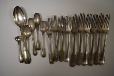 Warrnambool and District Historical Society Inc.
Functional object - Cutlery, George Rolfe, Mid to late 19th century
In 1854 in Melbourne George Rolfe Senior established an import business dealing in groceries, wines and spirits and tea. His son George, born in England, took over the business of Rolfe and Co in 1871. A keen sportsman, George Rolfe’s love of fishing led him to take frequent holidays in Warrnambool. He began buying blocks of land near the mouth of the Hopkins River in Warrnambool in the 1870s. By the 1880s Rolfe owned 50 acres in the Hopkins River area and named the property, Lyndoch. He built stables, chaff and bone sheds, a jetty, a boatshed, a water well, a windmill, a reservoir and extensive gardens. He also bought the nearby properties of Shipley and Fairy Hill, establishing a stud farm and breeding cattle. In 1891 he married Jane Ann Lake, the widow of his property manager, and when he died in 1919 his step-daughters, Florence and Annie Lake, inherited Lyndoch. The property was sold and became an aged care facility in 1952. The cutlery items were in use in the building erected by Florence Lake in 1920 and known today as Lyndoch but the ‘R’ monogram on the items suggest that they belonged to George Rolfe or even his father before him.These cutlery items are of considerable importance as mementoes of George Rolfe and his family. They were prominent in Warrnambool’s history in the late 19th and early 20th centuries with the establishment and development of the property, Lyndoch, near the mouth of the Hopkins River. These are 17 pieces from a silver cutlery set that belonged to the Rolfe family (one tablespoon, six large forks, five smaller forks, four small spoons and one mustard spoon.) All the pieces of cutlery have a monogrammed ‘R’ at the end of the handles. Twelve of the items are tarnished and one small spoon is very worn. All the items have six hallmarks. ‘R’george rolfe, lyndoch, warrnambool, rolfe & co. melbourne, florence lake, lyndoch warrnambool., history of warrnambool -
 Lakes Entrance Historical Society
Photograph - P.S. Tanjil, Cornell F, 1880 c
Also new sepia print 10 x 15 cm. See also Peter Synan's book 'Highways of Water'Sepia photograph showing paddle steamer Tanjil at Latrobe Wharf. Swan Hotel on left and Victoria Hotel on right. Timber stacked on wharf. People on wharf and in small boats on river on left, taken from opposite side of Latrobe River. This scene is immediately downstream of present swing bridge on Latrobe River. Sale Victoriaboats and boating, jetties, hotels -
 Lakes Entrance Historical Society
Photograph - Bridges, Murray Views Gympie, 1980
Photo printed on Jumbo card by Murray Views, Gympie QLDColour photograph showing swing bridge on Latrobe River, shows north facing side of bridge, willows on opposite bank on site of Latrobe River wharf, river running very high, two red gum trees in water on left. Longford Victoriabridges, waterways -
 Bendigo Historical Society Inc.
Booklet - The Eppalock Catchment
Yellow covered booklet of 36 pages typed and photocopied. On front cover 'Project for Environmental Education Resources Development.' 'THE EPPALOCK CATCHMENT Sub Catchment Study What's up the Creek?' B&W sketch of a river on front cover. This is a resource document for teachers and includes a diagram of the Water Cycle, maps of the Pohlman's Creek Catchment area and soil studies. -
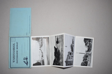 Warrnambool and District Historical Society Inc.
Souvenir - Warrnambool Photographic Booklet, 1940s
This item is a souvenir booklet that would have been purchased by a tourist in the Warrnambool district in the mid 20th century. The photographs are representative of the tourist attractions of the area – Hopkins Falls, the mouth of the Hopkins River, Shelly Beach, the Breakwater, the Botanical Gardens etc. Tourism in Warrnambool began to be important towards the end of the 19th century when the coastal scenery, the beaches and the Sea Water Baths were advertised to promote Warrnambool as a spa resort town. Today tourism is a major industry in the city. This item is of minor interest as a souvenir of the type of postcard purchased by tourists in the mid 20th century. This is a piece of blue paper folded in two with black and blue printing on the front and back covers and an image of two kookaburras on the front cover. In the back of the front cover is pasted a strip of paper containing 13 black and white photographs folded in concertina fashion to form a booklet. The front cover has an extension that fits into a slot on the back cover to enclose the photographs. There is space for a stamp and an address on the front cover and space for the name of the sender on the back cover. There is pencil writing on the space for the stamp.Warrnambool Photographic Booklet 9d. (ninepence) warrnambool souvenir, warrnambool tourist attractions -
 Bendigo Historical Society Inc.
Slide - EPPALOCK. CONSTRUCTION, c1962
Eppalock. Construction. Shows water in the bottom of the lake, or possibly river running into it. Markings: Eppalock Dam. Dec 1962 near Lyal.Kodakcivil engineering, water supply, eppalock -
 National Vietnam Veterans Museum (NVVM)
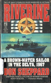
Book, Sheppard, Don, Riverine: A Brown-Water Sailor in the Delta, 1967
Patrolling the Mekong Delta's Bassac River in hot-rodded cabin cruisers called PBRs, the U.S. Navy's brown-water sailors in 1967 were like tigers waiting for the cage door to open. Then Lieutenent Commander Don Sheppard cut them loose.Patrolling the Mekong Delta's Bassac River in hot-rodded cabin cruisers called PBRs, the U.S. Navy's brown-water sailors in 1967 were like tigers waiting for the cage door to open. Then Lieutenent Commander Don Sheppard cut them loose.vietnam war, 1961-1975 - riverine operations - american, u.s. navy, brown-water sailors, mekong delta, bassac river -
 Bendigo Historical Society Inc.
Document - BENDIGO FOUNDRIES
... harvester Hugh Victor McKay Holland Bros. State Rivers & Water ...Typed notes on Bendigo Foundaries. Notes mention some of the foundries that were in Bendigo, the work they did, where they were, and where some of their work can be seen.document, bendigo foundaries, horwood & sons, girton college, the victoria foundary, andrew harkness & co, palmer river diggings, george lansell, robert harkness, abraham roberts, united iron works, laanecoorie weir, bendigo railway station, coles new world supermarket, target stores, taylor horsefield's engineering works, improved harvester, hugh victor mckay, holland bros., state rivers & water supply, civic buildings, st aiden's, bendigo hospital, carter & brown, osborn bros, bendigo building society, a'becket chambers, fortuna, george lansell, lansell mine, army survey regiment, jorgenson's, st killian's fence, redpath & brown -
 Greensborough Historical Society
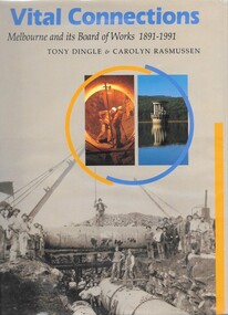
Book, Tony Dingle et al, Vital connections: Melbourne and its Board of Works 1891-1991, by Tony Dingle & Carolyn Rasmussen, 1991_
Centenary history of the Melbourne and Metropolitan Board of Works, the organisation responsible for Melbourne's water supply, sewerage and industrial waste disposal, town planning, rivers & creeks, metropolitan parks and building of freeways until its closure in 1992.432 p. hardback, black & white photographsmmbw, melbourne and metropolitan board of works -
 Kew Historical Society Inc
Work on paper - Sepia Wash & Ink, G B Richardson, Creek and Old Watering Stage, on the Yarra, East Collingwood, 1854, 1854
... to the Kew side of the river. Creek and Old Watering Stage ...Blind Creek was located between the Abbotsford Convent and what is now the Collins Bridge in Studley Park. In an 1858 map of East Collingwood by Clement Hodgkinson, in the State Library of Victoria, one can see how the creek was originally a significant landmark in Collingwood; remaining vacant land until a barrel drain enclosed it. The area was later filled in, surveyed and developed. The position where Blind Creek entered the Yarra was in the immediate vicinity of Hodgson’s Punt, which had linked Kew to the other side of the Yarra from 1839. The Punt was purchased by the Colonial Government in 1852 and was in use until the opening of the Studley Park Road (Johnston Street) Bridge in 1858 made its continued use redundantThe point of view selected by the artist for the watercolour is from the banks of Blind Creek in East Collingwood, looking across the Yarra to the Kew side of the river.Inscribed verso 'Creek and Old Watering stage, on the Yarra East Collingwood 1854 / Trees, stage, &c have long since disappeared / [Artist Signature] / FT 110 / Creek itself now being filled in 1903.gb richardson, blind creek - abbotsford, yarra river - abbotsford (vic) - kew (vic), colonial artists, australian art - 19th century, george bouchier richardson -
 Bendigo Historical Society Inc.
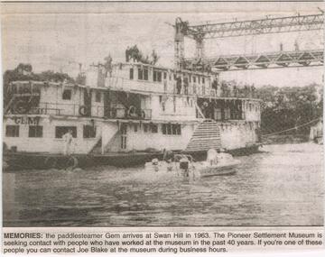
Newspaper - JENNY FOLEY COLLECTION: MEMORIES
The paddle steamer "Gem was first launched in 1876 as a passenger and cargo mode of transport on the Murray River. In the '30's and '40's it operated as a tourist passenger boat. In 1948 it sunk in 15 feet of water but was repaired and refloated. It was retired in 1950. In 1962 it was sold to the Swan Hill pioneer Settlement. The Swan Hill Folk Museum was Australia's first open air museum and opened to the public in 1966, It was renamed the Pioneer Settlement.Bendigo Advertiser ''The way we were'' from 2003. Memories: the paddle steamer Gem arrives at Swan Hill in 1963. the pioneer Settlement Museum is seeking contact with people who have worked at the museum in the past 40 years. The clip is in a folder.newspaper, bendigo advertiser, the way we were -
Bendigo Historical Society Inc.
Photograph - ELMORE FIELD DAYS
Elmore Field Days were first held in 1964.Aerial photograph of Elmore Field Days site. Undated but possibly 1969-1970. Image shows exhibitor stands, roadways and parked vehicles. Oh LH side of image is a water course, an anabranch of the Campaspe River. Site is now a camping reserve as the Elmore Field Days is now (2022) held at a nearby site.event, agriculture, elmore field days -
 University of Melbourne, Burnley Campus Archives
Album - CD black and white and sepia prints, Hilda Dance, 1935-1936
Hilda Dance (graduated 1936, staff 1941-47)2 copies of a CD with photographs taken by Hilda Dance. (1) 4 female students working in a flower bed. (2) 6 students at a flower show. (3) 4 female students on the lawn wearing dresses. (4) Group of students sitting on benches on the lawn. (5) 1936 Year Group. (6) 4 female students playing around on the lawn. (7) Students working near the Luffmann Ponds. (8) Newspaper cutting: 'She knows all the answers.' Student answering questions on a Vegetable Growing public day. (9) 2 female students playing around on the lawn. (10) Possibly an excursion to the zoo-man holding snake. (11) Female student bathing in the Yarra River. (12) Female student climbing a tree with steps cut into it, not Burnley. (13) Students bathing in the Yarra River. (14) 4 female students on the lawn wearing dresses. (15) Group of male students with lawnmower. (16) George Barnett/Russ? (17) Female student watering seedlings. (18) Group of male students with lawnmower. (19) Orchard Border. (20) Group of male students with lawnmower.hilda dance, female students, flower beds, students, flower show, luffmann ponds, students working outside, recreation, lawnmower, tree climbing, george barnett, orchard border, lily ponds -
 Kiewa Valley Historical Society
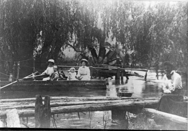
Photo - Water Wheel and Punt on the Kiewa River - Tangambalanga Homestead
In early times, Homesteads were part of pastoral runs many of which had frontage onto a river.Tangambalanga Homestead, on the Kiewa River, was subdivided in 1862 from T. Mitchell to Thomas BrownBlack and white shiny photo with women and children in a boat on 'flood' waters and a woman on the bank near a footbridge or jetty. The ladies are wearing hats, long skirts and blouses. In the background there is a large water wheel and trees. This photo is published on Page 19 of 'A History of the Kiewa Valley' by Esther Temple and David Lloyd.tangambalanga homestead, water wheel on the kiewa river, punt on the kiewa river -
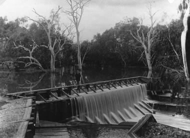
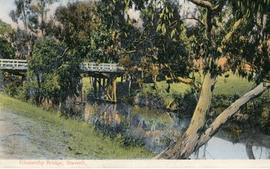
 Stawell Historical Society Inc
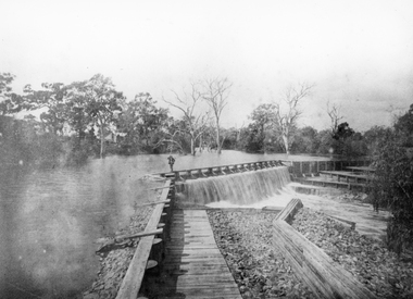
Photograph, Wimmera River Weir at Glenorchy
Wimmera River Weir Glenorchy. Part of Wimmera Mallee Irrigation SystemBlack & white photograph of a weir across a river. Construction of weir is log & wood with a person walking along the weir. Trees in the background.Reproduction Rights Reserved Copied by State Library of Victoriawater -
 Stawell Historical Society Inc
Postcard, Faux Weir on the Wimmera River near Lubeck 1909 -- Postcard
Faux Weir built across Wimmera River near Lubeck 1909. Worksheet records state photo copied from a postcard.Black & white photograph of a weir on a water body with trees in the back ground. A person is standing on the timber weir.water -
 Lakes Entrance Historical Society
Photograph, Lakes Post Newspaper, 1991
Black and white photograph of four members of Tambo River Improvement Trust. A Neil, Charles Hogan, Alan Sommerville Ian Bulmer Lakes Entrance Victoriawater resources -
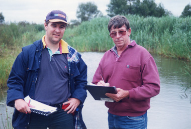 Lakes Entrance Historical Society
Photograph - Tambo Water Board, Lakes Post Newspaper, 1999
Colour photograph of Robin Minter Mitchell River Supervisor and Simon Robertson East Gippsland Catchment Authority Engineer beside a waterway during a training course East Gippsland Victoriawater resources -
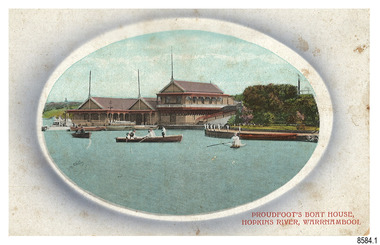 Flagstaff Hill Maritime Museum and Village
Postcard - Historical, Warrnambool, Proudfoot’s Boat House, Hopkins River, Warrnambool, Early 20th century
The nine postcards in this set were donated together and date to the early 1900s. All but one postcard in this set shows images of Warrnambool, in the Western District of Victoria; the other has a London image. The postcards were all printed in Great Britain according to that country’s postal regulations. All cards have titles on the front printed in red. The majority of the images on the cards are attributed to photographer Joseph Jordan and belong to the Jordan Series. The back of these cards has an outline for a postage stamp, a vertical dividing line and a heading on each side of the line to separate the Correspondence from the Address. Postcards or ‘correspondence cards’ appeared in Britain in 1894. They were plain cards with a space for the message on one side and an address on the other; regulations didn’t allow anything but the address to be written on the ‘address’ side. In 1902 the British regulations then allowed a picture to be printed on the front and the address on the back, so messages had to be written on the picture side. Soon, the regulations changed and the back was divided for a message and the address. Proudfoots Boat House – Proudfoot’s Boathouse is at 2 Simpson Street Warrnambool, on the banks of the Hopkins River. In the 1880s it was a venue for hiring boats for rowing, fishing, sailing and picnics. It was a popular destination for tourists coming from Melbourne for a day or weekend outing. The beautiful historic Victorian period building was designed, built and established by Thomas Proudfoot. He applied to build a boat jetty in 1885. He died in 1900 and his wife Catherine took over, running it for many years. Later her son Bruce and after that her granddaughter Ena Hunt and her husband took over; it remained in the family until 1979. The buildings, including the ‘U’ shaped jetty and tearooms, were restored and modified in the 1990s by the Warrnambool Sports Club, under the control of the Warrnambool City Council. Joseph Jordan - Joseph Jordan was born in 1841 in Leicester England. When he was 16 he joined the 7th Queen's Own Hussars and was sent to India at the outbreak of the mutiny. He took part in the relief of Lucknow and remained in India for eleven years. It was during this time, he became interested in photography. He was posted to New Zealand and later came to Victoria, becoming a sergeant major of the Mounted Rifles. In the mid-1880s he came to the Western district where he was responsible for establishing units of the Mounted Rifles in various country towns such as Dunkeld, Mortlake, Panmure, Bushfield, Koroit etc. He resigned from the army in 1889 and set up a professional photography studio in Liebig Street, Warrnambool. He became very well known in the Western District for family photographs, official photographs of local councillors and groups as well as views of local scenery. In 1891 he photographed the wrecked barque ‘Fiji’ at ‘Wrecks Beach’ near Princetown. His business was taken over by his son Arthur around 1917. Joseph was a keen rifle shot and in 1924 he donated the "Jordan Shield" as a prize to the Victorian Rifle Association. He was made a "Life Honorary Member" of the Warrnambool Returned Soldiers League and in 1933 he was recognised as being the oldest living soldier in Victoria. Joseph died in 1935 aged 95.This card is the only one of the nine cards with the location of Warrnambool added to the name 'Joseph Series'. It is also the only one that has text within the outline for the postage stamp. The font used for the test of the headings is slightly different to the other cards. Joseph Jordan is a significant figure in Warrnambool history as he helped to establish early units of the Mounted Rifles (G Company) in local towns during the late 1880's and later, photographed local scenes, groups and citizens of early Warrnambool. This postcard of Proudfoot's Boathouse is of historical significance for is connection with Proudfood’s Boathouse. Proudfoot’s Boathouse is an example of late-Victorian recreational and tourist facilities. Boathouses were popular 19th-century tourist and recreational attractions, providing refined and healthy activity. This boathouse shows the early realisation of the tourism and leisure potential of seaside towns such as Warrnambool, a potential that has become increasingly important as port uses have ceased and other industries have been subjected to financial pressure. Proudfoot's Boathouse is of social significance because it illustrates the continuity of the attraction of this kind of leisure facility. Although the glory days of boathouses were in the 19th century, those that survive continue to be well patronised. Proudfoot's Boathouse has been an important recreational facility and attraction for tourists flocking to the Hopkins River, one of the State's most popular boating and fishing resorts, since 1885.” (Statement of Significance is from the Victorian Heritage Register)Postcard, one of nine, landscape orientation. Coloured photograph print within an oval border and mauve-toned shading. Cameo Image of figures in three rowing boats on still water beside a building with three gable roofs and decorative verandas. Other boats are moored at the landing in front of the building. The roofs each have a tall pole at the front. There is a park right of the building that also has a landing. In the background is a grassed slope and the sea. Reverse has printed inscriptions and an outline for a postage stamp. There is no correspondence written on the card. The card is one of the Jordan Series by Joseph Jordan, printed in Great Britain in the early 1900s. Front, in red: “PROUDFOOT’S BOAT HOUSE / HOPKINS RIVER, WARRNAMBOOL” Reverse in black: “Jordan Series Warrnambool” “POST CARD” “Printed in Great Britain” “This space may be used for Communication” “The Address to be written here” Within the stamp outline: “3 / BRITISH / MANUFACTURE"flagstaff hill maritime museum, flagstaff hill maritime village, flagstaff hill maritime museum and village, maritime museum, warrnambool, great ocean road, warrnambool and district, warrnambool scenes, local scenes, views of warrnambool, joseph jordan, jordan series, jordan photography, postcard, souvenir, correspondence, cameo postcard, landscape, proudfoots boat house, boat house, proudfoots, hopkins river, boats for hire, row boats, recreation -
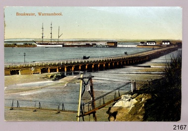 Flagstaff Hill Maritime Museum and Village
Postcard - Historical, maritime, Breakwater, Warrnambool, ca. 1890
The local photograph shows the original footbridge across the Merri River near its mouth, the Viaduct road and the Warrnambool Breakwater with the Titan crane on it. The breakwater's construction was completed in 1890, the year this photograph was taken. The Viaduct has since been filled in to prevent water from passing through the pylons, and the footbridge has been replaced. The postcard has a personal message written on the back to a Dr Scott from May. The photograph is locally significant for recording the completion of the Warrnambool Breakwater, for showing the original design of the Viaduct and for a clear view of the original footbridge across the Merri River. It is also of significance for being used by a female to send a greeting from Warrnambool to a doctor. Postcard, coloured, of the Warrnambool Breakwater, with the Merri River footbridge and the Viaduct in the foreground. Pedestrians and a horse-drawn cart are on the Viaduct, The lifeboat house and other buildings are near the beginning of the Breakwater. A three-masted sailing ship is in port. The photograph was taken from Middle Island. A personal message is written on the back, and a title is printed on the front. Produced in Germany in the 1890s.On the front: "Breakwater, Warrnambool" Written on the reverse: "Warrnambool Wishing Dear Dr Scott the Compliments of the Season With love and best wishes, From May"warrnambool, shipwreck coast, flagstaff hill, flagstaff hill maritime museum, flagstaff hill maritime village, postcard, coloured postcard, warrnambool breakwater, breakwater, viaduct, 1890s, merri river footbridge, dr scott, may -
 Warrnambool and District Historical Society Inc.
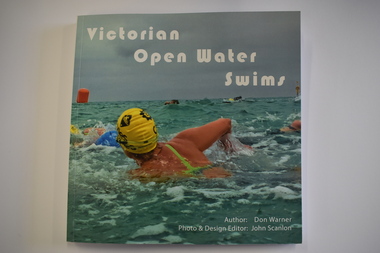
Book, Don Warner, Victorian Open Water Swims, 2021
This book by Don Warner contains information on present day open water swims in VictoriaThis is paper back book of 128 pages. The front cover has a colour photograph of a swimmer and white printing. The spine has black printing and the back cover has a colour photograph of swimmers and black printing. The pages contain printed text and colour photographsnon-fictionThis book by Don Warner contains information on present day open water swims in Victoriaswimming races in warrnambobol, open water swimming -
 Flagstaff Hill Maritime Museum and Village
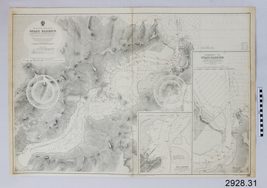
Document - Navigation Chart, British Admiralty, Otago Harbour, Late 19th to Early 20th century
Navigation charts are used by mariners around the world for navigating waterways. This chart was created for Otago Harbour in New Zealand. A ship "Otago' was named after this harbour and was once commanded by renowned maritime author Joseph Conrad. That ship now lies in Otago Bay, in the Derwent River, Tasmania.This navigation chart was published by the British Admiralty cartographer, to aid mariners to navigate the world's water bodies. Navigation charts are still used today, along with other navigational instruments.British Admiralty Navigation Chart - Otago Harbour, South Island, New Zealand. Chart shows insets with finer detail of important sections.warrnambool, shipwrecked-coast, flagstaff-hill, flagstaff-hill-maritime-museum, maritime-museum, shipwreck-coast, flagstaff-hill-maritime-village, shipwrecked-artefact, british admiralty navigation chart, navigation chart, british admiralty, otago harbour, south island, new zealand, otago bay, derwent river, tasmania, joseph conrad -
 City of Greater Bendigo - Civic Collection
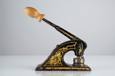
Ceremonial object - Common Seal
Bridgewater is a situated 39km northwest of Bendigo and 170 km from Melbourne. It was established as a crossing point over the Loddon River for gold diggers en route to the Inglewood gold diggings. As gold began to dry up in the district the town of Bridgewater developed due to its proximity to the river which it relied on for industries such as brewing, farming and market gardens. As demand on the water supply grew, the Water Works were established to ensure supply and manage the quality of the water for drinking. Decorated hand operated cast iron embosser with 40mm seal head attached. Gold and orange painted decorations extend from top edge of handle to sides of base. Original knob has been replace with a newer wooden knob. Well used showing all over signs of wear. Seal is for the Bridgewater Waterworks Trust 1927.Bridgewater Waterworks Trust 1927.loddon shire -
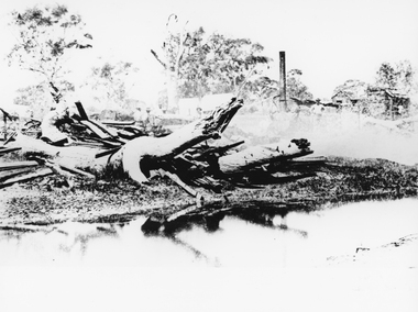 Stawell Historical Society Inc
Photograph, Bush Sawmill beside the Wimmera River in Dunolly 1993
Dunolly 1993. Bush Sawmill beside the Wimmera River. Wooden buildings in Background. Chimney of what appears to be a steam driven engine with flywheel and belt driving a saw bench. Several men in photo. Original photographic taken by Charles Nettleton.Black & white photograph of timber and logs beside a water body with buildings and a tall chimney in the background. Around seven people in the background.Bush Saw Mill Wimmera River near Stawell 1877 Negative Reversed copy also 2641water industry -
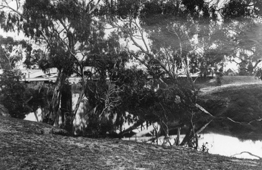 Stawell Historical Society Inc
Photograph, Bridge over Wimmera River at Glenorchy
Bridge over Wimmera River at Glenorchy. Church in background on right is the former Presbyterian now United Church. Original photograph taken by Charles Nettleton.Black & white photograph of a timber lined water body with bridge and building in the background. water -
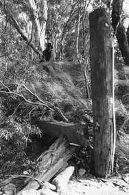 Stawell Historical Society Inc
Photograph, Timber poles with gauges to measure river height
... Timber poles with gauges to measure river height. water ...Timber poles with gauges to measure river height.Black and white photo of a bush setting with a tall timber pole which has been cleared around.water -
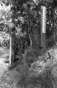 Stawell Historical Society Inc
Photograph, Timber poles with gauges to measure river height
... Timber poles with gauges to measure river height. water ...Timber poles with gauges to measure river height.Black and white photo of two timber poles with measurements attached. Bush setting beside a water body.water -
 Stawell Historical Society Inc
Postcard, Bridge at Glenorchy -- Postcard -- Coloured
Coloured postcard of Bridge at Glenorchy.Coloured Post card of a timber bridge over a river in bush settings.On Front Glenorchy Bridge, Stawell On Reverse Printed in Germany 155/81467 Post Card This Space May be used for Correspondence. This for Address Only.water