Showing 2502 items matching "saw"
-
 Orbost & District Historical Society
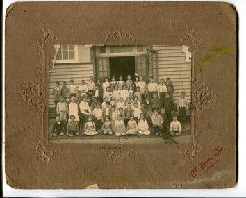
black and white photograph, Vogt, Stanley, C 1915-1920
This is a photograph of students of Orbost State School. Mary Gilbert has identified the girl holding the sign as Pen Gilbert. The 19th of March 1886 proved an important day in the lives of many early settlers in the Orbost area, because on this day the Orbost State School opened. The fact that the school had first operated temporarily in a leased building, and on a half-time basis with SS2745 Jarrahmond, did not dampen the enthusiasm of the local inhabitants as they saw their offspring commence their education under the guidance of HT Campbell Mackay. However he remained in charge only until 12th of May 1886. The second HT, John Rowe, served until 1908. On 30th of June 1887, a portable room was provided; it being brought to the area by schooner. The school now had accommodation for 30 pupils; the teacher's welfare was considered because quarters of two rooms were attached. As the population increased so did the needs of the school. This was reflected in the provision of a larger classroom in 1898. During 1910-11 the first approaches were made to the Department for the establishment of a HES in Orbost and this became a reality in 1912. Orbost HES supplied post-primary education in the district until a high school was built in 1948.This photograph is associate with the history of education i n Orbost.a black / white photograph mounted on brown card. It is of a group of school children in front of an open doorwaay of a timber building. A female teacher is seated on a chair among them. A girl in the front is holding a board with what appears to be handwritten in white chalk on a blackboard -"Grades 111 & 1V Orbost".at bottom - "X PEN GILBERT"education-orbost-state-school -
 Flagstaff Hill Maritime Museum and Village
Functional object - Floor ash Tray, 1900 to 1960s
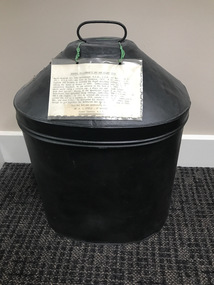
The word ashtray came into use around the 1920 and is a receptacle for ash from cigarettes and cigars and are typically made of fire retardant material such as glass, heat resistant plastic, pottery, metal, or stone. The most common ashtray design is a shallow cylinder with a flat base, designed to rest on a table. Other ashtrays, particularly in public places, are either wall or floor mounted. While simple, utilitarian forms of ashtrays existed long before the 19th century, it was during the start of the 20th century that the design, aesthetics and their popularity took off. As more women began to smoke. in the early 1900s, the ashtray went closer to being an art form as many women avoided the use of the traditional ashtray as it failed to reflect their feminine values, regarded as an item rather basic in design the general societal through of the time was that smoking was an activity exclusive to men. What emerged were detailed, often very fancy ashtrays acceptable to women depicting either pastoral scenes or vibrantly coloured landscapes. As time went on, and the onset of women smoking both cigars and cigarettes became less of a departure from the average person, ashtrays saw a decline in design and aesthetics beginning more of a shift towards practicality. The subject item is a primitive form of ashtray used in public spaces any time from the 1920-1960s and is not associated with an historic person or event. However the item could have come from the Warrnambool Town Hall given the inscription on the base of the item.Ash tray-large rectangular floor model with cement sheet lining. Made from a wooden box covered with textured metal on the outsideThe metal has a relief design embossed at the top back "smokers" and "Town Hall" printed on bottom.flagstaff hill, warrnambool, flagstaff-hill-maritime-museum, maritime-museum, shipwreck-coast, flagstaff-hill-maritime-village, ash tray, town hall, cigarette tray, smoker's ash tray -
 Flagstaff Hill Maritime Museum and Village
Functional object - Floor ash Tray, 1900 to 1960s
The word ashtray came into use around the 1920 and is a receptacle for ash from cigarettes and cigars and are typically made of fire retardant material such as glass, heat resistant plastic, pottery, metal, or stone. The most common ashtray design is a shallow cylinder with a flat base, designed to rest on a table. Other ashtrays, particularly in public places, are either wall or floor mounted. While simple, utilitarian forms of ashtrays existed long before the 19th century, it was during the start of the 20th century that the design, aesthetics and their popularity took off. As more women began to smoke. in the early 1900s, the ashtray went closer to being an art form as many women avoided the use of the traditional ashtray as it failed to reflect their feminine values, regarded as an item rather basic in design the general societal through of the time was that smoking was an activity exclusive to men. What emerged were detailed, often very fancy ashtrays acceptable to women depicting either pastoral scenes or vibrantly coloured landscapes. As time went on, and the onset of women smoking both cigars and cigarettes became less of a departure from the average person, ashtrays saw a decline in design and aesthetics beginning more of a shift towards practicality. The subject item is a primitive form of ashtray used in public spaces any time from the 1900 -1960s and is not associated with an historic person or event. However the item could have come from the Warrnambool Town Hall given the inscription on the base of the item.Ash tray-large rectangular floor model made from a wooden box covered with textured metal on the outsideThe metal has a relief design embossed at the top back "smokers" and "Town Hall" printed on bottom.flagstaff hill, warrnambool, flagstaff-hill-maritime-museum, maritime-museum, shipwreck-coast, flagstaff-hill-maritime-village, ash tray -
 Kew Historical Society Inc
Container - Presentation Jewellery Box, 1948
In 1948, the citizens of Kew presented this jewellery box to the outgoing Mayor and Mayoress of Kew, Cr & Mrs W D Vaughan. In 2021, it returned to Kew, thanks to the generous donations of our Friends of the Collection. William David Vaughan to whom the jewel box was presented in 1948 was a publisher, politician and historian, born in 1897 at Heathcote. By 1922, he had become a publisher and Secretary of Victorian Newspapers Ltd. In October 1922, he married Muriel Gladys Frazer in Bendigo. He purchased 'Elsfield' in Cotham Road, renamed it 'Carramar', and resided there for almost fifty years. His wife, the Mayoress, was an accomplished pianist and entertained the wives of councillors and supported many charitable works from her home. In 1926, Vaughan founded a local newspaper, the Kew Advertiser. During his second term as Mayor, he was elected president of Melbourne Suburban Newspapers’ Association, In April 1947, he was appointed to and later became chairman of the Free Library Services Board. In 1960, he published his history of Kew - 'Kew's Civic Century'. Vaughan’s third term as Mayor in 1962-63 saw the erection of the pavilion at Victoria Park and the final clean-up of the Outer Circle Railway. He died in September 1976. This inlaid and engraved jewellery box was part of a larger donation made to the Mayor and Mayoress of Kew in 1948 by the citizens of the municipality. It is the only 'civic award' in the collection given to a former civic leader and complements the large collection of civic portraits in the collection. The box is additionally significant because of its association with William David Vaughan - newspaper proprietor, local politician, and local historian. A presentation jewellery box, she-oak with barber pole inlay adorned with an Australian silver plaque.Engraved inscription on silver plaque - "Presented to Cr & Mrs W.D. Vaughan With The Esteem And Appreciation Of The Citizens Of Kew And In Recognition Of their Services As Mayor And Mayoress 1947-48. 28th July 1948"w d vaughan, mayors of kew, kew advertiser, kew (vic.) -- history -
 Brighton Historical Society
Dress, Cocktail dress, c1980s
This item is part of the Di Reidie collection. Diane Reidie was a much loved volunteer and President of Brighton Historical Society from 1999 until 2016. Originally from New Zealand, Di and her family lived in Male Street, Brighton for many years. A vibrant and energetic person with a zest for life and a gift for bringing people together, Di was a friend to many in the Bayside community and active in local community organisations. Her tireless work as President of BHS saw her named Bayside Citizen of the Year in 2008. As a seller and collector of vintage clothing, she was passionate about fashion history; one of her many enduring contributions to BHS was her extensive work in preserving, developing and promoting the Society's costume collection. In 2018-19, Di donated more than one hundred items from her personal vintage clothing collection to the Society. The collection, which includes clothing, hats, handbags and shoes from local and international designers, is representative of Di's wide-ranging interests, colourful personality, creativity, humour and love of fashion and travel. Di purchased this 1980s cocktail dress second hand around 2000 to wear as part of a Dame Edna Everage costume to a hen's party. A blue mid calf length polyester dress with prominent gathered and padded shoulders, horizontally ruched bodice, high scoop neckline, full length sleeves and dropped waist. The skirt is of plain blue polyester mock wrap style with ruched blue spiral detail on left leg seam of bodice to skirt. The dress secures at the centre back with a nylon zip and self covered button. The sleeve is lined with mauve / pink polyesterManufacturers label "Teena Varigos" "Size 14, To Fit Bust 90cm, Waist 70cm, Hip 95cm" "Do not iron pleating" "100% Polyester, Warm Iron, Dry Clean Only"teena varigos, costume party, cocktail dress, 1980s, dame edna everage, di reidie -
 Melbourne Legacy
Container - Case, Major-General Gellibrand's Cap and Helmet Case
The black tin helmet case is an object owned by Major-General Gellibrand who motivated Legatee Stan Savige to found Legacy. Major-General Sir John Gellibrand KCB, DSO and Bar, D. de G(Fr), DSM (US), was born in Tasmania in 1874. After schooling in England and Germany he entered then Royal Military College, Sandhurst, taking the Sword of Honour in 1893. Commissioned into the South Lancashire Regiment, he saw service in the Boer War, 1900. This case which would carry a service cap, a dress cap and a pith helmet dates from that period. Moving to the Manchester Regiment in 1902, Captain Gellibrand then attended Staff College, Camberley 1906-7 and was posted DAA and QMG Ceylon. In 1912 he retired and returned to Tasmania. He joined the AIF as a Captain in 1914, served in 24th Battalion and commanded 6th Brigade and then 3rd Division. He motivated his erstwhile Staff Captain Stan Savige to get together the Melbourne men who founded Legacy in 1923. This Hat Box was generously donated by Mr W C Steele of Wangaratta. Former Captain AIF. Melbourne Legacy keeps the case on display in the main reception foyer.The helmet case being on prominent display at Melbourne Legacy shows the respect Legacy holds for Major-General Gellibrand.Black tin case that contained Major-General Gellibrand's Cap and Helmet. Has two compartments separated by a flap that can lift.Typed label in plastic sleeve attached by green twine.helmet, case, john gellibrand -
 Broadmeadows Historical Society & Museum
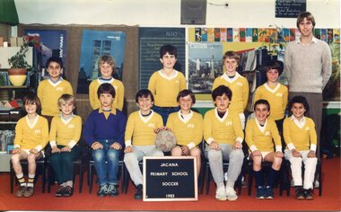
Photograph - Team Photograph, Jacana Primary School: Soccer Team 1983
Jacana Primary School was established in 1959 during a period of rapid suburban development in Melbourne’s northern suburbs. The post-war era saw significant investment in public infrastructure, including schools, to support growing communities shaped by migration and housing expansion. Jacana, located near Broadmeadows, became home to many working-class families, including newly arrived migrants, contributing to a rich and diverse social fabric. By the early 1980s, schools like Jacana Primary were not only centres of education but also vital community hubs. Sporting activities, particularly team sports like soccer, played a central role in student life. They promoted physical health, teamwork, and social inclusion, while also reflecting broader cultural influences—especially as soccer gained popularity among migrant communities. The 1983 soccer team photograph captures this dynamic period, showcasing the importance of extracurricular activities in fostering school spirit and community engagement. It also reflects the values of public education at the time: equity, participation, and the celebration of diversity. Such images serve as enduring records of how schools contributed to shaping local identity and cohesion during a transformative era in Melbourne’s suburban history. This 1983 colour photograph of Jacana Primary School’s soccer team captures the energy and camaraderie of a school that served as a cornerstone of its community from 1959 until its closure in the early 2000s. More than a simple team portrait, the image reflects the vibrant sporting culture that was integral to student life and community engagement during the early 1980s. The photograph preserves cherished memories of teamwork, school pride, and youthful enthusiasm, offering insight into the social dynamics and extracurricular values of the time. It stands as a visual testament to the role of sport in fostering inclusion, resilience, and a sense of belonging among students—qualities that defined Jacana Primary’s enduring legacy in Melbourne’s northern suburbs.A colour photograph of a school Soccer team on satin finish photo paper.PH-4465 (white label) Top Left Corner PH-5431(blue label) Top Right Corner Manufactures mark; Fujicolor/ Paperjacana primary school, photograph, school photograph, education, soccer team, 1983 -
 National Wool Museum
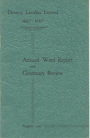
Journal, Dennys, Lascelles Limited 1857-1957 Annual Wool Report and Centenary Review, 1957
"Dennys, Lascelles Limited 1857-1957 Annual Wool Report and Centenary Review". Apart from the annual report, this booklet also contains a brief history of Dennys, Lascelles Limited from its founding in 1857 up to 1957. A copy of both the ‘Dennys Lascelles Limited 1857-1957: Annual Wool Report & Centenary Review’ & ‘Staff Reunion Souvenir Programme, 1988’ was donated to the museum in 2021. These were duplicate items so only their story was retained in addition to the image of Rita located in Multimedia. “Enclose two items which may be of interest to add to your collection. They belonged to my mother, Rita Sedgwick (nee Glenn), who died earlier this year in April. She worked for Dennys Lascelles in two separate periods. First as a young girl, who had finished her schooling, at Morongo Presbyterian ladies College, having been sent as boarder there by her parents from their farm at Mathoura (just north of Echuca). This period was from 1942 — 1947. It was her second job out of school having worked first at the then Geelong Telephone Exchange. She would commute daily to work on a bicycle from where she was then living in Drumcondra. She had the front office role of receptionist and telephonist driving an old manual switchboard. The old front desk was her domain. She departed in 1947, shortly after she was married in late 1946. She spoke fondly of her times at the company as a young girl in her late teens and early twenties. Her second stint was much later, but again as the front-desk telephonist and receptionist commencing in 1972, ending 11 years later in 1983. This was a period when Sir Henry Bolte was on the Board, Don Urqhuart was MD, Ray Hobson was General Manger, Cliff Bone the company Secretary, Peter Keys the CFO and Jim Hay was also on the Executive team. While there were some 25 years between her periods of service, she welcomed the chance to re-join the company. Again, it was a time of hard work, and good friends. The busy times were the wool auctions, when the Firm would be visited by representatives of the big Japanese trading houses such as Mitsui, and Kanematsu. The Chief Auctioneer, Mr. Reeves (I can't recall his first name), would hold court at the now demolished Geelong Wool Exchange — I saw him in action once — what a sight. The huge show floors in the Denny's building would be full of open bales and samples for the buyers to inspect, and for mum days would start at 0800, and finish at 1800 or later. In quieter times over summer, it was reported that the empty show floor would provide an excellent arena for the more enthusiastic cricketers to get in a bit of practise with a tennis ball at lunch and after closing time! Dennys was a full-service firm for wool growers, with branches all over the Western Districts as far afield as Mt Gambier, but through Timboon, Warrnambool, and the like, as I am sure you are aware. She also saw the merger of Dennys and Strachan to create DSM, and later the amalgamation with AML&F to create Dennys AML (I think). She saw the change from the old manual switch board to the then latest of PABX technologies and was part of the team the relocated from the original offices to the new address on the south side of Brougham Street. Along with the shift from the large show floor-based sales of the past. She retired from fulltime work in mid-1983, again with fond memories and friendships that lasted a lifetime. I found these two items among her things recently, and felt that given her connection to the industry, and the place in which the Museum now resides you may like to add them to the collection. I hope you can find a home for them, and that they might add a little to the story that the wool museum now houses and curates.” "Dennys, Lascelles Limited Annual Wool Report and Centenary Review, August 1957". Apart from the annual report, this booklet also contains a brief history of Dennys, Lascelles Limited from its founding in 1857 up to 1957.Dennys, Lascelles Limited Annual Wool Report and Centenary Review, August 1957wool brokering, wool growing, dennys, lascelles limited -
 The Beechworth Burke Museum
Audio - Oral History, Jennifer Williams, Mr Clemence Orton, 7th December 2000
Clemence Orton was born in Beechworth in 1922 and lived his life in Murmungee on his parent’s property that he took over and ran working the land. He was schooled in Murmungee and interested in vet science. He served in WWII and was 24 years old when he returned. After World War II he took work experience with the local vet and attended his own farm stock, horses in particular. His knowledge of the area during his parent’s time and his families time saw him familiar with mining in the local area and Chinese miners through to farming techniques and practices. He was known as a ‘local resident with an encyclopaedic knowledge of local history'. Clemence married Dorothy and raised his family in Murmungee. He passed away on January 17th 2007. This oral history recording was part of a project conducted by Jennifer Williams in the year 2000 to capture the everyday life and struggles in Beechworth during the twentieth century. This project involved recording seventy oral histories on cassette tapes of local Beechworth residents which were then published in a book titled: Listen to what they say: voices of twentieth century Beechworth. These cassette tapes were digitised in July 2021 with funds made available by the Friends of the Burke. Clemence Orton’s family has lived in the Beechworth and Murmungee region for over a century. Through his experience living on the land he is able to shine a light on farming and life on the land, farming techniques and mining history in the region. Clemence Orton was know for his knowledge of local history and lived in the region making his involvement in this oral history project important. This oral history account is socially and historically significant as it is a part of a broader collection of interviews conducted by Jennifer Williams which were published in the book 'Listen to what they say: voices of twentieth-century Beechworth.' While the township of Beechworth is known for its history as a gold rush town, these accounts provide a unique insight into the day-to-day life of the town's residents during the 20th century, many of which will have now been lost if they had not been preserved.This is a digital copy of a recording that was originally captured on a cassette tape. The cassette tape is black with a horizontal white strip and is currently stored in a cleat flat plastic rectangular container. It holds up to 40 minutes of recordings on each side. Mr Clemence Orton /listen to what they say, beechworth, oral history, burke museum, orton, vet, mining history, chinese miners, clemence orton -
 Bendigo Military Museum
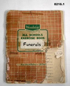
Administrative record - FUNERALS LIST BENDIGO RSL, C.1965 to 2008
RSL Funeral services conducted by the Bendigo RSL Sub Branch and Bendigo District RSL Sub Branch for their departed members. .1) The first entry in the book is 27.10.1965 and the last on 27.12.2008. A large amount of the entries were written by Jack Barnes OAM during his 43 years as Secretary of the Sub Branch. (Refer Cat No 8040). The vast majority of the funerals were conducted by the President at the time, Committee members or members who were heavily involved with the Sub Branch. It's virtual who's who of Presidents, Life members and notables. 1988 saw the most funerals conducted during that year being 60, other figures varied from mid 20's to mid 50's per year. One notable funeral Volunteer was John Balsillie MBE. (Refer Cat No 118.5) Between 2.1.2007 - 27.12.2008 there was 80 funerals with John conducting 78 of them. There is an interesting addition of one funeral by Jack Barnes on 31.1.1968 was that it was (111 degrees). .2) The list on the sheet with a note, "For Cindy" who was the BDRSL Office Person at the time. these were for 2007, there was 19 on the sheet with only 9 in the book, 7 of the names have a red tick beside. The sheet was written by John Balsillie. John had conducted funerals for many years pre 2007 and for more years after. .1) Exercise book, cover red & white with green text central of front, section of front page missing, pages are blue ruled lines, columns added in red or blue pen, 3 columns per page with year at the top, columns have the deceased persons name, funeral date, person who conducted the RSL funeral, some pages the persons unit served with has been added. all entries are hand written on red or blue pen. .2) Sheet of paper with hand written names in blue pen with month and date, some have a red tick beside.On front on a white sticker "Funerals" in black texta pen. Hand written in blue pen, "27.10.1965 to 27.12.2008". Inside front cover in blue pen by Jack Barnes, "Bugler as from Sept 84 - Les Warren 40 Story St Bgo phone 43007". In red pen, "Took Bugle to polish etc 5 ? 84"brsl, smirsl, bdrslinc, funerals -
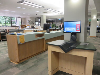 Federation University Historical Collection
Photograph - Colour, Julia Walsh, Front Desk at the E. J. Barker Library, Mount Helen Campus, Federation University Australia, 2020, 2020
Work began on the Library construction in 1968. This was when it was known as Ballarat College of Advanced Education - Mount Helen. The Library started on the ground floor in 1970. In 1971 a contract for a four-storey library was drawn up and construction began the same year. The building opened in 1973, occupying two stories of the current building. The library grew and with Commonwealth Grants was able to develop its collection. In 1987 the library achieved an annual budget of over $1 million. The Teachers Resource Collection was added and by 1989 the library expected to occupy the top three floors plus the lower ground floor. A flexible study area on the top floor was introduced 1990-1991. 2010 saw the completion of a new stage in the history of the library. It now includes new study and research areas including the Geoffrey Blainey Research Centre with access to the University's Art and Historical Collection. The E. J. Barker Library is named after a former Principal of the School of Mines Ballarat who then became the first Director of the Ballarat College of Advanced Education, now Federation University. Jack Barker played an active part in education and was awarded the Medal of the Order of Australia. After retirement in 1987, the College Council decided to name the Library after him in recognition of his achievements.Colour photograph of the ground floor of the E.J. Barker Library showing the front desk and automatic book check out. e.j. barker library -
 Halls Gap & Grampians Historical Society
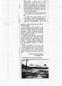
Newspaper - B/W
She was a guest house called "Myrtlebank" and she was a very gracious old residence in a near perfect setting, surrounded by the towering peaks of the Grampian Mountains in Victoria. She was visited by thousands in her time, many of whom returned year after year to enjoy her hospitality. I first visited her 40 years ago and she won my heart from the moment I saw her. In those days, guest houses were in their prime - motels were unheard of. To this day, I can recall the delicious meals at "Myrtlebank" with pure country cream and home grown produce featuring largely. All the guests would gather in the enormous sitting rooms warmed by huge log fires in colder weather and , in the evenings, all sorts of games would be played, charades being first favourite with young and old alike. Several days a week a bus would pick up guests, along with those from other guest houses, and surrounding areas would be visited. Mostly, though, we walked - sometimes right across behind the Wonderland Range to Mount Victory. Now, "Myrtlebank" is no more. The site where she once stood is at the bottom of the Bellfield Lake, covered forever with fathoms of water. But I and many others will always remember and love her. Letter to paper with photograph of MyrtlebankSubmitted by Mrs O. Woolcock, Tottenham Vic who won $15 prize describing accomodation for guests at Myrtlebankaccommodation, guesthouses, myrtlebank -
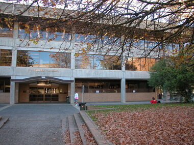 Federation University Historical Collection
Photograph - Colour, E. J. Barker Library, Mount Helen Campus, Federation University Australia - 2006, 2006
Work began on the Library construction in 1968. This was when it was known as Ballarat College of Advanced Education - Mount Helen. The Library started on the ground floor in 1970. In 1971 a contract for a four-storey library was drawn up and construction began the same year. The building opened in 1973, occupying two stories of the current building. The library grew and with Commonwealth Grants was able to develop its collection. In 1987 the library achieved an annual budget of over $1 million. The Teachers Resource Collection was added and by 1989 the library expected to occupy the top three floors plus the lower ground floor. A flexible study area on the top floor was introduced 1990-1991. 2010 saw the completion of a new stage in the history of the library. It now includes new study and research areas including the Geoffrey Blainey Research Centre with access to the University's Art and Historical Collection. The E. J. Barker Library is named after a former Principal of the School of Mines Ballarat who then became the first Director of the Ballarat College of Advanced Education, now Federation University. Jack Barker played an active part in education and was awarded the Medal of the Order of Australia. After retirement in 1987, the College Council decided to name the Library after him in recognition of his achievements.Colour photograph showing the entrance to the E. J. Barker Library at the Mount Helen Campus of Federation University - Ballarat. Lawn, trees and gardens provide a pleasant area for students and staff. Building design allows for large windows giving light into the various areas.ballarat college of advanced education, e.j. barker library, teachers resource collection, study area, geoffrey blainey research centre, art collection, historical collection, jack barker, medal of the order of australia -
 Puffing Billy Railway
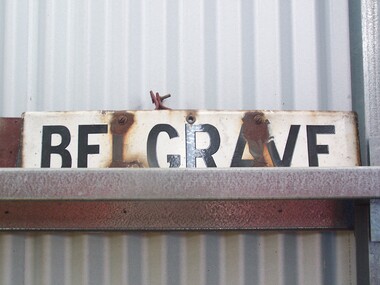
Station Sign - Belgrave
Belgrave railway station is the terminus of the electrified line from Melbourne in Victoria, Australia, serving the eastern Melbourne suburb of Belgrave. Opened as Monbulk on 18 December 1900, it was renamed Belgrave on 21 November 1904. It was upgraded to a Premium station on 2 July 1996. The station was originally on the Upper Ferntree Gully – Gembrook narrow gauge line. It, along with the rest of the line, officially closed on 30 April 1954. However it saw further use between 1955 and early 1958, when trains were operated by the Puffing Billy Preservation Society in co-operation with the Victorian Railways. The station area re-opened on 19 February 1962 when the line as far as Belgrave was converted to broad gauge and used electric traction as part of the suburban network.[1] It has one island platform with two faces. It is serviced by Metro Trains' Belgrave line services The Puffing Billy Railway Belgrave station is located 100 metres north of the station and is accessible via a short footpath. It was required to be located further down the line than the original narrow-gauge station (which was approximately where the current suburban station car park is located). ref: https://en.wikipedia.org/wiki/Belgrave_railway_station photos at http://www.vicrailstations.com/Gembrook/Belgrave/Belgrave.htmlHistoric - Victorian Railways Station sign used at Belgrave StationStation Sign - Belgrave Metal sign - white enamel back ground with black letters Belgravepuffing billy, victorian railways, belgrave station -
 Robin Boyd Foundation
Painting, Asher Bilu, Solstar, 1968
Robin Boyd most likely saw Solstar at Asher Bilu's exhibition at South Yarra Gallery in September 1968. In November 1968, Robin Boyd arranged for the loan of this painting from South Yarra Gallery to Australian Pavilion at Expo '70 in Osaka, where Boyd was appointed Exhibit Architect. It hung in the bedroom over a bed, containing a life-size cut-out figure by Bruce Petty, in the Model House Interior exhibit on modern living in the Space Tube. On its return from Expo, the painting was in transit at the Boyd's home in Walsh Street and they liked it so much that they decided to buy it. Solstar originally hung on the wall at the end of the galley kitchen. The artwork at the Boyd's home in Walsh St has been moved several times over the years. Solstar now hangs above the dining table, but at the time of Solstar's acquisition, the Boyds hung the painting "Winter Triumphant" (1920) by Penleigh Boyd, Robin Boyd’s father, above the dining table. In early 2021, Asher and Luba Bilu visited Walsh St to view Solstar again. Asher was extremely happy with how the painting looked and its condition 53 years after painting it. He requested it be hung a little higher and he returned in April to make some minor restorations to remove scratches. Silver mixed media with large black circular area in the central lower half. On reverse has the title: Solstar/A. Bilu/Arrow showing which way up. Unsigned on the front.asher bilu, penleigh boyd, expo 70, osaka, robin boyd, south yarra gallery, walsh st artwork, ohm2022, ohm2022_13 -
 Bendigo Historical Society Inc.
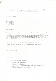
Letter - MERLE HALL COLLECTION: ROSALIND PARK CREATIVE VILLAGE BENDIGO PROJECT LETTERS, 1995
MERLE HALL COLLECTION: ROSALIND PARK CREATIVE VILLAGE BENDIGO PROJECT LETTERS Merle Hall Collection: Rosalind Park Creative Village Bendigo Project Letters from Maery Hall (Gabriel). 6 December 1995 To: Merle Hall Arts Bendigo From Maery Hall Content: Outline of what is involved in the design and working of the project. Enclosed are three page of the design outline, one page of tool drawings, three sheets of sketches, photograph of small mosaic sketch using rocks I brought back from my last visit. The letter also contains: Materials, Tools, labour, other needs, Time, Costs and the Council’s role. 6 November 1995 To: Merle Hall Secretary Arts Bendigo From Maery Hall Content: Contains a rough sketch of the project. Note that the sketch is missing. 29 January 1997 To: Merle Hall Arts Bendigo From Maery Gabriel Content: Contains a drawing for the remaining pavement areas that I submitted before and measurements for the actual slabs for 22 square m. for the two. The result will be 2 (saddle reefs) in style. Also mentioned are two options for payment. Receipts also included for the last two payments and the saw. Thank you for sending the form of transfer for the saw. (Note the drawing is missing) 10 April 1997 To: Merle Hall Arts Bendigo From Maery Gabriel (artist in Mosaic) Content: Thank you for your letter of 9 March and further discussions on costs and layouts. 25 Feb 1997 To: Maery Gabrel, ‘Morningswood’ Peterson’s Road Ellinbank 3821 From Merle Hall Secretary Arts Bendigo Content: Apologies for the delay in not answering last letters and drawings. Mentions the need to meet with the Council to discuss the completion of the project and the need to enquire about funding from the Premier’s ‘community support fund’ 9 March 1997 To: Maery Gabrel From Merle Hall Secretary Arts Bendigo Content: Follow-up letter from 25 Feb 1997 concerning the last sections of the mosaic project. Outcome of meeting with Bernard Smith of the City of Greater Bendigo One local business sponsor prepared to donate a small amount towards completion of the project P.S. Sharon Hackett: the painter would love to receive her questionnaire from you. 22 Dec 1996 To: Maery Gabrel From Merle Hall Secretary Arts Bendigo Content: Enclosed is a form to cover transfer of ownership of the diamond saw as recommended by an adviser. P.S. the transfer is made out to ‘Hall’ - your name under our contracts. I’ve used your name for the address. 20 Dec 1996 To: Maery Gabrel From Merle Hall Secretary Arts Bendigo Content: Arts Bendigo Inc. of P.O. Box 563, Bendigo, 3552, agrees to the transfer of ownership to Maery Hall of ‘Morningswood’, Peterson’s Rd., Ellinbank, 3821 of one ‘Stubbie electric Bricksaw. Purchased from DEMBICON on May 25th, 1996 Diamond Blade for $1650, now valued at $1200 Part payment for the contractor of a mosaic pavement around the poppet lookout in Rosalind Park Bendigo. 30 Nov 1995 To: Maery Gabrel From Merle Hall Secretary Arts Bendigo Content: The enclosed survey sketches just arrived. Formal approval from the commissioners. Early next year the poppet head will be re-painted and have scaffolding there for a time but shouldn’t be a problem. 9 January 1996 To: Maery Gabrel From Merle Hall Secretary Arts Bendigo Content: Summary of discussions with the John Little V.A.C. and Roni Schell from ‘Future Connections’ re her DEET submission and Bernard King from the City and one of the Commisioners. A non-specific plan for being ‘contracted and not employed’ An expectation the ‘Future Connections’ would then offer you separate contract to conduct workshops for their clients and develop tutorials. 9 November 1995 To: Maery Hall From Merle Hall Secretary Arts Bendigo Content: Sketches enclosed for the poppet head site and comments on them from the City Council. 20 January 1997 From: Maery Gabiel Artist in Mosaic (formerly Maery Hall) To: Merle Hall Secretary Arts Bendigo Content: Receipt of $5000 plus one ‘Stubbie Electric Bricksaw, with stand, serial number 0002056 being payment under contract no. 2 for work on mosaic payments in Bendigo. 20 May 1996 List of Materials and equipment required for Mosaic and tools to be mademaery hall, arts bendigo -
 National Wool Museum
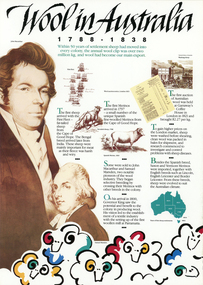
Archive - Wool in Australia, 1990s
Part of a collection of books, manuals, photographs, letters and clothing relating to the working life of Stuart Ascough. Stuart's career in the wool industry spanned over 43 years from 1960 to 2003 in various roles including Topmaking Plant Manager at Courtaulds Ltd. in Spennymore, U.K., Operations Manager at Port Phillip Mills in Williamstown Victoria, Marketing Executive, Early Stage Wool Processing at the International Wool Secretariat Melbourne, Australia and General Manager of Victoria Wool Processors Pty. Ltd. in Laverton North, Victoria. Throughout his career Stuart travelled extensively, and in the 1990s worked at many topmaking mills in China on quality improvement projects. He also provided technical advice and training at mills in India, Ukraine, Lithuania, Kyrgyzstan, Russia, Latvia, Byelorussia and other parts of Europe and Asia.Concertina A4 sized leaflet outlining the history of wool in Australia from 1788 to 1988 in four pages with colour graphics and black text.page 1: Wool in Australia / 1 7 8 8 - 1 8 3 8 / Within 50 years of settlement sheep had moved into / every colony, the annual wool clip was over two / million kg, and wool had become our main export page 2: Wool in Australia / 1 8 3 8 - 1 8 8 8 / The first 100 years saw Australia become the / world's leading producer of wool. Our economy's / strength depended on the wool clip. page 3: Wool in Australia / 1 8 8 8 - 1 9 3 8 / By the late 1930's, wool represented over 62% of / the total export value of primary products. Australia's / fine wool was in great demand worldwide. page 4: Wool in Australia / 1 9 3 8 - 1 9 8 8 / In the 50 years leading up to our Bicentenary, / many developments in the sheep and wool / industry have maintained Australia's place / as the leading producer of wool.stuart ascough, international wool secretariat, victoria wool processors, port phillip mills pty ltd, topmaking, career, wool industry, mills, leaflet -
 Eltham District Historical Society Inc
Photograph, Murchison Gap, Autumn Excursion, Hume and Hovell's 1824 expedition, 26 May 1996, 26/05/1996
[article by Bettina Woodburn in EDHS Newsletter No. 109, July 1996:] ON THE TRAIL OF HUME AND HOVELL - REPORT ON THE AUTUMN EXCURSION - On a green and fresh morning (Sunday 26th May 1996) the Cobb and Co coach (driven by the most obliging Peter Tampion) set off in a north easterly direction from Eltham to connect with Hume and Hovell's route on their 1824 explorations of central Victoria. The Society would follow a series of monuments erected for the 1924 centenary of the expedition from King Parrot Creek (Tuesday 7th December 1824), through Strath Creek, over Sunday Creek (Sunday 12th December 1824) at Broadford, Tullamarine, St Albans, Deer Park, through Werribee, skirting east of the You Yangs to Lara and Avalon Beach. Because their distance-measuring wheel had broken and a one degree mistake was made in calculations, the two leaders of the original group of six convict-companions arrived at Corio Bay, instead of the expected Western Port, discovered earlier by Flinders. From below Mt. Disappointment (Hume and Hovell's difficulties in "scrambling over brush and rock", "leeches in forest, as well as no water", "cutting grass 4-5 ft. high", dreadful scrub", "devil flies") we took an easier route, saw the Strath Creek memorial in ground fog and a wonderful "field of dreams", the Hume-Hovell privately owned cricket ground with its white picket boundary fence. Now, after a steep climb, in sunshine under gums we stretched and viewed magnificent rolling hills and fog-filled valleys - not "smoke from Aborigines' bush fires". After morning tea at Broadford we followed the Sunday Creek valley beside the Hume Freeway, passed the Wallan Wallan Rest Area (more appropriately Hume and Hovell Rest Area) to tum right at Beveridge. In Gellibrand Hill Park, near the headwaters of the Moonee Ponds Creek, we experienced the landscape the first European settlers saw - huge river red gums and rolling pastures. The gardens and sheltered courtyard of the 1840s, timber, brought from .....[?] prefabricated Woodlands Homestead, provided a pleasant lunch stop. We enjoyed a private tour, panoramic views over Melbourne and surroundings and the excitement of arriving and departing aircraft. Our next river crossing was at Werribee, "in a vast treeless plain", then we drove on by-ways no coach had previously travelled, to find "an immense sheet of water" salty Corio Bay, off-course to the west. In late afternoon of a super, calm, late autumn day we headed homewards. Back at Eltham we were rather surprised to find that we had travelled a total of 347 km. Thanks again to Russell Yeoman for his research and organization. What a wonderful day! Three colour photographsactivities, murchison gap, murchison valley -
 Eltham District Historical Society Inc
Photograph, Hume and Hovell Monument, Broadford, Autumn Excursion, Hume and Hovell's 1824 expedition, 26 May 1996, 26/05/1996
[article by Bettina Woodburn in EDHS Newsletter No. 109, July 1996:] ON THE TRAIL OF HUME AND HOVELL - REPORT ON THE AUTUMN EXCURSION - On a green and fresh morning (Sunday 26th May 1996) the Cobb and Co coach (driven by the most obliging Peter Tampion) set off in a north easterly direction from Eltham to connect with Hume and Hovell's route on their 1824 explorations of central Victoria. The Society would follow a series of monuments erected for the 1924 centenary of the expedition from King Parrot Creek (Tuesday 7th December 1824), through Strath Creek, over Sunday Creek (Sunday 12th December 1824) at Broadford, Tullamarine, St Albans, Deer Park, through Werribee, skirting east of the You Yangs to Lara and Avalon Beach. Because their distance-measuring wheel had broken and a one degree mistake was made in calculations, the two leaders of the original group of six convict-companions arrived at Corio Bay, instead of the expected Western Port, discovered earlier by Flinders. From below Mt. Disappointment (Hume and Hovell's difficulties in "scrambling over brush and rock", "leeches in forest, as well as no water", "cutting grass 4-5 ft. high", dreadful scrub", "devil flies") we took an easier route, saw the Strath Creek memorial in ground fog and a wonderful "field of dreams", the Hume-Hovell privately owned cricket ground with its white picket boundary fence. Now, after a steep climb, in sunshine under gums we stretched and viewed magnificent rolling hills and fog-filled valleys - not "smoke from Aborigines' bush fires". After morning tea at Broadford we followed the Sunday Creek valley beside the Hume Freeway, passed the Wallan Wallan Rest Area (more appropriately Hume and Hovell Rest Area) to tum right at Beveridge. In Gellibrand Hill Park, near the headwaters of the Moonee Ponds Creek, we experienced the landscape the first European settlers saw - huge river red gums and rolling pastures. The gardens and sheltered courtyard of the 1840s, timber, brought from .....[?] prefabricated Woodlands Homestead, provided a pleasant lunch stop. We enjoyed a private tour, panoramic views over Melbourne and surroundings and the excitement of arriving and departing aircraft. Our next river crossing was at Werribee, "in a vast treeless plain", then we drove on by-ways no coach had previously travelled, to find "an immense sheet of water" salty Corio Bay, off-course to the west. In late afternoon of a super, calm, late autumn day we headed homewards. Back at Eltham we were rather surprised to find that we had travelled a total of 347 km. Thanks again to Russell Yeoman for his research and organization. What a wonderful day! Colour photographactivities, broadford, hume and hovell, monument -
 Eltham District Historical Society Inc
Photograph, Hume and Hovell Monument, Autumn Excursion, Hume and Hovell's 1824 expedition, 26 May 1996, 26/05/1996
[article by Bettina Woodburn in EDHS Newsletter No. 109, July 1996:] ON THE TRAIL OF HUME AND HOVELL - REPORT ON THE AUTUMN EXCURSION - On a green and fresh morning (Sunday 26th May 1996) the Cobb and Co coach (driven by the most obliging Peter Tampion) set off in a north easterly direction from Eltham to connect with Hume and Hovell's route on their 1824 explorations of central Victoria. The Society would follow a series of monuments erected for the 1924 centenary of the expedition from King Parrot Creek (Tuesday 7th December 1824), through Strath Creek, over Sunday Creek (Sunday 12th December 1824) at Broadford, Tullamarine, St Albans, Deer Park, through Werribee, skirting east of the You Yangs to Lara and Avalon Beach. Because their distance-measuring wheel had broken and a one degree mistake was made in calculations, the two leaders of the original group of six convict-companions arrived at Corio Bay, instead of the expected Western Port, discovered earlier by Flinders. From below Mt. Disappointment (Hume and Hovell's difficulties in "scrambling over brush and rock", "leeches in forest, as well as no water", "cutting grass 4-5 ft. high", dreadful scrub", "devil flies") we took an easier route, saw the Strath Creek memorial in ground fog and a wonderful "field of dreams", the Hume-Hovell privately owned cricket ground with its white picket boundary fence. Now, after a steep climb, in sunshine under gums we stretched and viewed magnificent rolling hills and fog-filled valleys - not "smoke from Aborigines' bush fires". After morning tea at Broadford we followed the Sunday Creek valley beside the Hume Freeway, passed the Wallan Wallan Rest Area (more appropriately Hume and Hovell Rest Area) to tum right at Beveridge. In Gellibrand Hill Park, near the headwaters of the Moonee Ponds Creek, we experienced the landscape the first European settlers saw - huge river red gums and rolling pastures. The gardens and sheltered courtyard of the 1840s, timber, brought from .....[?] prefabricated Woodlands Homestead, provided a pleasant lunch stop. We enjoyed a private tour, panoramic views over Melbourne and surroundings and the excitement of arriving and departing aircraft. Our next river crossing was at Werribee, "in a vast treeless plain", then we drove on by-ways no coach had previously travelled, to find "an immense sheet of water" salty Corio Bay, off-course to the west. In late afternoon of a super, calm, late autumn day we headed homewards. Back at Eltham we were rather surprised to find that we had travelled a total of 347 km. Thanks again to Russell Yeoman for his research and organization. What a wonderful day! Two colour photographsactivities, hume and hovell, monument -
 Eltham District Historical Society Inc
Photograph, Hume and Hovell Monument, Broadford, Autumn Excursion, Hume and Hovell's 1824 expedition, 26 May 1996, 26/05/1996
[article by Bettina Woodburn in EDHS Newsletter No. 109, July 1996:] ON THE TRAIL OF HUME AND HOVELL - REPORT ON THE AUTUMN EXCURSION - On a green and fresh morning (Sunday 26th May 1996) the Cobb and Co coach (driven by the most obliging Peter Tampion) set off in a north easterly direction from Eltham to connect with Hume and Hovell's route on their 1824 explorations of central Victoria. The Society would follow a series of monuments erected for the 1924 centenary of the expedition from King Parrot Creek (Tuesday 7th December 1824), through Strath Creek, over Sunday Creek (Sunday 12th December 1824) at Broadford, Tullamarine, St Albans, Deer Park, through Werribee, skirting east of the You Yangs to Lara and Avalon Beach. Because their distance-measuring wheel had broken and a one degree mistake was made in calculations, the two leaders of the original group of six convict-companions arrived at Corio Bay, instead of the expected Western Port, discovered earlier by Flinders. From below Mt. Disappointment (Hume and Hovell's difficulties in "scrambling over brush and rock", "leeches in forest, as well as no water", "cutting grass 4-5 ft. high", dreadful scrub", "devil flies") we took an easier route, saw the Strath Creek memorial in ground fog and a wonderful "field of dreams", the Hume-Hovell privately owned cricket ground with its white picket boundary fence. Now, after a steep climb, in sunshine under gums we stretched and viewed magnificent rolling hills and fog-filled valleys - not "smoke from Aborigines' bush fires". After morning tea at Broadford we followed the Sunday Creek valley beside the Hume Freeway, passed the Wallan Wallan Rest Area (more appropriately Hume and Hovell Rest Area) to tum right at Beveridge. In Gellibrand Hill Park, near the headwaters of the Moonee Ponds Creek, we experienced the landscape the first European settlers saw - huge river red gums and rolling pastures. The gardens and sheltered courtyard of the 1840s, timber, brought from .....[?] prefabricated Woodlands Homestead, provided a pleasant lunch stop. We enjoyed a private tour, panoramic views over Melbourne and surroundings and the excitement of arriving and departing aircraft. Our next river crossing was at Werribee, "in a vast treeless plain", then we drove on by-ways no coach had previously travelled, to find "an immense sheet of water" salty Corio Bay, off-course to the west. In late afternoon of a super, calm, late autumn day we headed homewards. Back at Eltham we were rather surprised to find that we had travelled a total of 347 km. Thanks again to Russell Yeoman for his research and organization. What a wonderful day! Colour photographactivities, broadford, hume and hovell, monument -
 Eltham District Historical Society Inc
Photograph, Strath Creek, Autumn Excursion, Hume and Hovell's 1824 expedition, 26 May 1996, 26/05/1996
[article by Bettina Woodburn in EDHS Newsletter No. 109, July 1996:] ON THE TRAIL OF HUME AND HOVELL - REPORT ON THE AUTUMN EXCURSION - On a green and fresh morning (Sunday 26th May 1996) the Cobb and Co coach (driven by the most obliging Peter Tampion) set off in a north easterly direction from Eltham to connect with Hume and Hovell's route on their 1824 explorations of central Victoria. The Society would follow a series of monuments erected for the 1924 centenary of the expedition from King Parrot Creek (Tuesday 7th December 1824), through Strath Creek, over Sunday Creek (Sunday 12th December 1824) at Broadford, Tullamarine, St Albans, Deer Park, through Werribee, skirting east of the You Yangs to Lara and Avalon Beach. Because their distance-measuring wheel had broken and a one degree mistake was made in calculations, the two leaders of the original group of six convict-companions arrived at Corio Bay, instead of the expected Western Port, discovered earlier by Flinders. From below Mt. Disappointment (Hume and Hovell's difficulties in "scrambling over brush and rock", "leeches in forest, as well as no water", "cutting grass 4-5 ft. high", dreadful scrub", "devil flies") we took an easier route, saw the Strath Creek memorial in ground fog and a wonderful "field of dreams", the Hume-Hovell privately owned cricket ground with its white picket boundary fence. Now, after a steep climb, in sunshine under gums we stretched and viewed magnificent rolling hills and fog-filled valleys - not "smoke from Aborigines' bush fires". After morning tea at Broadford we followed the Sunday Creek valley beside the Hume Freeway, passed the Wallan Wallan Rest Area (more appropriately Hume and Hovell Rest Area) to tum right at Beveridge. In Gellibrand Hill Park, near the headwaters of the Moonee Ponds Creek, we experienced the landscape the first European settlers saw - huge river red gums and rolling pastures. The gardens and sheltered courtyard of the 1840s, timber, brought from .....[?] prefabricated Woodlands Homestead, provided a pleasant lunch stop. We enjoyed a private tour, panoramic views over Melbourne and surroundings and the excitement of arriving and departing aircraft. Our next river crossing was at Werribee, "in a vast treeless plain", then we drove on by-ways no coach had previously travelled, to find "an immense sheet of water" salty Corio Bay, off-course to the west. In late afternoon of a super, calm, late autumn day we headed homewards. Back at Eltham we were rather surprised to find that we had travelled a total of 347 km. Thanks again to Russell Yeoman for his research and organization. What a wonderful day! Colour photographactivities, monument, hume and hovell, murchison valley, strath creek -
 Eltham District Historical Society Inc
Photograph, Murchison Gap viewed from Strath Creek, Autumn Excursion, Hume and Hovell's 1824 expedition, 26 May 1996, 26/05/1996
[article by Bettina Woodburn in EDHS Newsletter No. 109, July 1996:] ON THE TRAIL OF HUME AND HOVELL - REPORT ON THE AUTUMN EXCURSION - On a green and fresh morning (Sunday 26th May 1996) the Cobb and Co coach (driven by the most obliging Peter Tampion) set off in a north easterly direction from Eltham to connect with Hume and Hovell's route on their 1824 explorations of central Victoria. The Society would follow a series of monuments erected for the 1924 centenary of the expedition from King Parrot Creek (Tuesday 7th December 1824), through Strath Creek, over Sunday Creek (Sunday 12th December 1824) at Broadford, Tullamarine, St Albans, Deer Park, through Werribee, skirting east of the You Yangs to Lara and Avalon Beach. Because their distance-measuring wheel had broken and a one degree mistake was made in calculations, the two leaders of the original group of six convict-companions arrived at Corio Bay, instead of the expected Western Port, discovered earlier by Flinders. From below Mt. Disappointment (Hume and Hovell's difficulties in "scrambling over brush and rock", "leeches in forest, as well as no water", "cutting grass 4-5 ft. high", dreadful scrub", "devil flies") we took an easier route, saw the Strath Creek memorial in ground fog and a wonderful "field of dreams", the Hume-Hovell privately owned cricket ground with its white picket boundary fence. Now, after a steep climb, in sunshine under gums we stretched and viewed magnificent rolling hills and fog-filled valleys - not "smoke from Aborigines' bush fires". After morning tea at Broadford we followed the Sunday Creek valley beside the Hume Freeway, passed the Wallan Wallan Rest Area (more appropriately Hume and Hovell Rest Area) to tum right at Beveridge. In Gellibrand Hill Park, near the headwaters of the Moonee Ponds Creek, we experienced the landscape the first European settlers saw - huge river red gums and rolling pastures. The gardens and sheltered courtyard of the 1840s, timber, brought from .....[?] prefabricated Woodlands Homestead, provided a pleasant lunch stop. We enjoyed a private tour, panoramic views over Melbourne and surroundings and the excitement of arriving and departing aircraft. Our next river crossing was at Werribee, "in a vast treeless plain", then we drove on by-ways no coach had previously travelled, to find "an immense sheet of water" salty Corio Bay, off-course to the west. In late afternoon of a super, calm, late autumn day we headed homewards. Back at Eltham we were rather surprised to find that we had travelled a total of 347 km. Thanks again to Russell Yeoman for his research and organization. What a wonderful day! Colour photographactivities, hume and hovell, murchison valley, murchison gap, strath creek -
 Eltham District Historical Society Inc
Photograph, Autumn Excursion, Hume and Hovell's 1824 expedition, 26 May 1996, 26/05/1996
[article by Bettina Woodburn in EDHS Newsletter No. 109, July 1996:] ON THE TRAIL OF HUME AND HOVELL - REPORT ON THE AUTUMN EXCURSION - On a green and fresh morning (Sunday 26th May 1996) the Cobb and Co coach (driven by the most obliging Peter Tampion) set off in a north easterly direction from Eltham to connect with Hume and Hovell's route on their 1824 explorations of central Victoria. The Society would follow a series of monuments erected for the 1924 centenary of the expedition from King Parrot Creek (Tuesday 7th December 1824), through Strath Creek, over Sunday Creek (Sunday 12th December 1824) at Broadford, Tullamarine, St Albans, Deer Park, through Werribee, skirting east of the You Yangs to Lara and Avalon Beach. Because their distance-measuring wheel had broken and a one degree mistake was made in calculations, the two leaders of the original group of six convict-companions arrived at Corio Bay, instead of the expected Western Port, discovered earlier by Flinders. From below Mt. Disappointment (Hume and Hovell's difficulties in "scrambling over brush and rock", "leeches in forest, as well as no water", "cutting grass 4-5 ft. high", dreadful scrub", "devil flies") we took an easier route, saw the Strath Creek memorial in ground fog and a wonderful "field of dreams", the Hume-Hovell privately owned cricket ground with its white picket boundary fence. Now, after a steep climb, in sunshine under gums we stretched and viewed magnificent rolling hills and fog-filled valleys - not "smoke from Aborigines' bush fires". After morning tea at Broadford we followed the Sunday Creek valley beside the Hume Freeway, passed the Wallan Wallan Rest Area (more appropriately Hume and Hovell Rest Area) to tum right at Beveridge. In Gellibrand Hill Park, near the headwaters of the Moonee Ponds Creek, we experienced the landscape the first European settlers saw - huge river red gums and rolling pastures. The gardens and sheltered courtyard of the 1840s, timber, brought from .....[?] prefabricated Woodlands Homestead, provided a pleasant lunch stop. We enjoyed a private tour, panoramic views over Melbourne and surroundings and the excitement of arriving and departing aircraft. Our next river crossing was at Werribee, "in a vast treeless plain", then we drove on by-ways no coach had previously travelled, to find "an immense sheet of water" salty Corio Bay, off-course to the west. In late afternoon of a super, calm, late autumn day we headed homewards. Back at Eltham we were rather surprised to find that we had travelled a total of 347 km. Thanks again to Russell Yeoman for his research and organization. What a wonderful day! Colour photographactivities, hume and hovell -
 Eltham District Historical Society Inc
Photograph, Sign to Hume and Hovell Cricket Ground, at Allandale Road, Strath Creek, Autumn Excursion, Hume and Hovell's 1824 expedition, 26 May 1996, 26/05/1996
[article by Bettina Woodburn in EDHS Newsletter No. 109, July 1996:] ON THE TRAIL OF HUME AND HOVELL - REPORT ON THE AUTUMN EXCURSION - On a green and fresh morning (Sunday 26th May 1996) the Cobb and Co coach (driven by the most obliging Peter Tampion) set off in a north easterly direction from Eltham to connect with Hume and Hovell's route on their 1824 explorations of central Victoria. The Society would follow a series of monuments erected for the 1924 centenary of the expedition from King Parrot Creek (Tuesday 7th December 1824), through Strath Creek, over Sunday Creek (Sunday 12th December 1824) at Broadford, Tullamarine, St Albans, Deer Park, through Werribee, skirting east of the You Yangs to Lara and Avalon Beach. Because their distance-measuring wheel had broken and a one degree mistake was made in calculations, the two leaders of the original group of six convict-companions arrived at Corio Bay, instead of the expected Western Port, discovered earlier by Flinders. From below Mt. Disappointment (Hume and Hovell's difficulties in "scrambling over brush and rock", "leeches in forest, as well as no water", "cutting grass 4-5 ft. high", dreadful scrub", "devil flies") we took an easier route, saw the Strath Creek memorial in ground fog and a wonderful "field of dreams", the Hume-Hovell privately owned cricket ground with its white picket boundary fence. Now, after a steep climb, in sunshine under gums we stretched and viewed magnificent rolling hills and fog-filled valleys - not "smoke from Aborigines' bush fires". After morning tea at Broadford we followed the Sunday Creek valley beside the Hume Freeway, passed the Wallan Wallan Rest Area (more appropriately Hume and Hovell Rest Area) to tum right at Beveridge. In Gellibrand Hill Park, near the headwaters of the Moonee Ponds Creek, we experienced the landscape the first European settlers saw - huge river red gums and rolling pastures. The gardens and sheltered courtyard of the 1840s, timber, brought from .....[?] prefabricated Woodlands Homestead, provided a pleasant lunch stop. We enjoyed a private tour, panoramic views over Melbourne and surroundings and the excitement of arriving and departing aircraft. Our next river crossing was at Werribee, "in a vast treeless plain", then we drove on by-ways no coach had previously travelled, to find "an immense sheet of water" salty Corio Bay, off-course to the west. In late afternoon of a super, calm, late autumn day we headed homewards. Back at Eltham we were rather surprised to find that we had travelled a total of 347 km. Thanks again to Russell Yeoman for his research and organization. What a wonderful day! Colour photographactivities, hume and hovell, allandale road, strath creek -
 Eltham District Historical Society Inc
Photograph, Autumn Excursion, Hume and Hovell's 1824 expedition, 26 May 1996, 26/05/1996
[article by Bettina Woodburn in EDHS Newsletter No. 109, July 1996:] ON THE TRAIL OF HUME AND HOVELL - REPORT ON THE AUTUMN EXCURSION - On a green and fresh morning (Sunday 26th May 1996) the Cobb and Co coach (driven by the most obliging Peter Tampion) set off in a north easterly direction from Eltham to connect with Hume and Hovell's route on their 1824 explorations of central Victoria. The Society would follow a series of monuments erected for the 1924 centenary of the expedition from King Parrot Creek (Tuesday 7th December 1824), through Strath Creek, over Sunday Creek (Sunday 12th December 1824) at Broadford, Tullamarine, St Albans, Deer Park, through Werribee, skirting east of the You Yangs to Lara and Avalon Beach. Because their distance-measuring wheel had broken and a one degree mistake was made in calculations, the two leaders of the original group of six convict-companions arrived at Corio Bay, instead of the expected Western Port, discovered earlier by Flinders. From below Mt. Disappointment (Hume and Hovell's difficulties in "scrambling over brush and rock", "leeches in forest, as well as no water", "cutting grass 4-5 ft. high", dreadful scrub", "devil flies") we took an easier route, saw the Strath Creek memorial in ground fog and a wonderful "field of dreams", the Hume-Hovell privately owned cricket ground with its white picket boundary fence. Now, after a steep climb, in sunshine under gums we stretched and viewed magnificent rolling hills and fog-filled valleys - not "smoke from Aborigines' bush fires". After morning tea at Broadford we followed the Sunday Creek valley beside the Hume Freeway, passed the Wallan Wallan Rest Area (more appropriately Hume and Hovell Rest Area) to tum right at Beveridge. In Gellibrand Hill Park, near the headwaters of the Moonee Ponds Creek, we experienced the landscape the first European settlers saw - huge river red gums and rolling pastures. The gardens and sheltered courtyard of the 1840s, timber, brought from .....[?] prefabricated Woodlands Homestead, provided a pleasant lunch stop. We enjoyed a private tour, panoramic views over Melbourne and surroundings and the excitement of arriving and departing aircraft. Our next river crossing was at Werribee, "in a vast treeless plain", then we drove on by-ways no coach had previously travelled, to find "an immense sheet of water" salty Corio Bay, off-course to the west. In late afternoon of a super, calm, late autumn day we headed homewards. Back at Eltham we were rather surprised to find that we had travelled a total of 347 km. Thanks again to Russell Yeoman for his research and organization. What a wonderful day! Colour photographactivities, hume and hovell -
 Eltham District Historical Society Inc
Photograph, Autumn Excursion, Hume and Hovell's 1824 expedition, 26 May 1996, 26/05/1996
[article by Bettina Woodburn in EDHS Newsletter No. 109, July 1996:] ON THE TRAIL OF HUME AND HOVELL - REPORT ON THE AUTUMN EXCURSION - On a green and fresh morning (Sunday 26th May 1996) the Cobb and Co coach (driven by the most obliging Peter Tampion) set off in a north easterly direction from Eltham to connect with Hume and Hovell's route on their 1824 explorations of central Victoria. The Society would follow a series of monuments erected for the 1924 centenary of the expedition from King Parrot Creek (Tuesday 7th December 1824), through Strath Creek, over Sunday Creek (Sunday 12th December 1824) at Broadford, Tullamarine, St Albans, Deer Park, through Werribee, skirting east of the You Yangs to Lara and Avalon Beach. Because their distance-measuring wheel had broken and a one degree mistake was made in calculations, the two leaders of the original group of six convict-companions arrived at Corio Bay, instead of the expected Western Port, discovered earlier by Flinders. From below Mt. Disappointment (Hume and Hovell's difficulties in "scrambling over brush and rock", "leeches in forest, as well as no water", "cutting grass 4-5 ft. high", dreadful scrub", "devil flies") we took an easier route, saw the Strath Creek memorial in ground fog and a wonderful "field of dreams", the Hume-Hovell privately owned cricket ground with its white picket boundary fence. Now, after a steep climb, in sunshine under gums we stretched and viewed magnificent rolling hills and fog-filled valleys - not "smoke from Aborigines' bush fires". After morning tea at Broadford we followed the Sunday Creek valley beside the Hume Freeway, passed the Wallan Wallan Rest Area (more appropriately Hume and Hovell Rest Area) to tum right at Beveridge. In Gellibrand Hill Park, near the headwaters of the Moonee Ponds Creek, we experienced the landscape the first European settlers saw - huge river red gums and rolling pastures. The gardens and sheltered courtyard of the 1840s, timber, brought from .....[?] prefabricated Woodlands Homestead, provided a pleasant lunch stop. We enjoyed a private tour, panoramic views over Melbourne and surroundings and the excitement of arriving and departing aircraft. Our next river crossing was at Werribee, "in a vast treeless plain", then we drove on by-ways no coach had previously travelled, to find "an immense sheet of water" salty Corio Bay, off-course to the west. In late afternoon of a super, calm, late autumn day we headed homewards. Back at Eltham we were rather surprised to find that we had travelled a total of 347 km. Thanks again to Russell Yeoman for his research and organization. What a wonderful day! Colour photographactivities, hume and hovell