Showing 174987 items
matching beach-street
-
 Eltham District Historical Society Inc
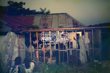
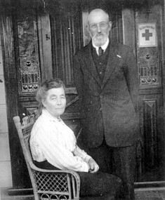
Photograph, Hans Gregory, Original 1860s William West house, Fabbro's Farm, Falkiner Street, Eltham, c.1990
Photos taken by Hans Gregory who along with partner Pauline Steele, rented the original old 1860s William West Cottage situated behind the Fabbro family home. Hans was employed as a Youth officer with the Shire of Eltham at the time and was the last tennant on the property. The property was sold and in 1995 was developed for residential housing as the Riverview Park estate. Guido Quarto Fabbro was born 21 August 1891 at Treppo Grande in the far northeast of Italy, the son of Giacomo Fabbro and Anna Geruzzi. Regina Moretti was born 6 March 1893 at Treppo Grande, Italy, the daughter of Giovanni Battista Moretti and Maria Teresa Coletti. Guido and Regina married about 1917 and they had two sons, Giacomo (John c.1918) and Maurie (c.1920). In 1925 Guido Fabbro departed his homeland from Genoa, arriving in Fremantle, Western Australia in June, travelling 3rd class aboard the ship, Caprera. Regina and their two boys followed a year later along with other family members arriving in Fremantle from Genoa 4 July 1926 aboard the Moncalieri. The Fabbros arrived in Eltham in 1933 and purchased a block of land from William West on the western side of Falkiner Street, extending to Ely and Porter Streets which had formerly been part of the West family orchard and dairy farm. As there was no fencing dividing the two properties, West served notice on Guido in December 1934 to bear half of the cost of £6. When payment was not forthcoming, West sued Guido in the Eltham Court in January 1935. Guido failed to appear and was not represented, and costs were ordered in West’s favour. Guido and Regina built a large Italianesque house on their property. The original 1860s cottage was relocated to the back of the block and was rented out (once to Alistair and Margot Knox). Guido also purchased land extending to the Diamond Creek on the eastern side of Falkiner Street and on the eastern side of Bell Street (opposite Eltham High School). The riparian soil was suitable for market gardening: Guido grew mainly tomatoes, but also pumpkins, cauliflowers, cabbages, peas, beans, lettuce, beetroot and zucchinis. Even the land surrounding the house was used. The produce was carted to Melbourne overnight for sale at the market. Guido died in 1970 and is buried in Eltham cemetery. Regina died 1986. She and their son John Patrick (Giacomo) Fabbro who died in 1984 are also buried at Eltham Cemetery. Guido’s son Maurie continued in his father’s footsteps until 2007, principally growing artichokes in later years. He died in 2009. The land on the eastern side of Falkiner Street now forms part of a Council reserve called “Barak Bushland”, the land on the western side having been sold off for residential subdivision. The Bell Street land is now public open space managed by Nillumbik Shire Council and called “Fabbro Fields”. There have been recent proposals to develop the site for sporting purposes or as a dog park or community garden. Provides an insight into early settler's farmhouses and farming property of the Eltham district.guido quarto fabbro, regina fabbro (nee moretti), william west, maurie fabbro, fabbro's farm, hans gregory, west family orchard, west dairy farm -
 Eltham District Historical Society Inc
Photograph - Photo postcard, J.H. Clark, Eltham, looking down Bridge Street near intersection with Main Road, c.1910
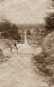
This postcard depicts the view down Bridge Street from east of Maria Street (Main Road) circa 1910. A man on a horse stands in the foreground. J.H. Clark Photo is stated under the title. From the same collection as accession no. 00778, (Yarra at Eltham) - sent from Eltham and addressed to "Mr J. L. Brown, "Elthamville", Tinning Street, Brunswick" "with love from Nellie" who was most probably a member of the extended Brown family, and no. 00779 (Pond near Eltham Park). "Dear John, As you see " can be ascertained on the reverse of this card. Sending postcards to family and friends including short messages was a common form of communication in the early 20th century. Photographer: J.H. Clark John Henry Clark was the youngest of three boys born to William Henry Clark (1823-1877) and Maria White (1843-1914). He and his brothers, William Charles Clark (1872-1945), Clement Kent Clark (1874-1912) operated a photography business (Clark Bros.) from 25 Thomas Street, Windsor near Prahran during the period c.1894 to 1914. Following death of Clement in September 1912 and their mother in 1914, the Clark Bros business appears to have dissolved, the premises demolished, and a new house was under construction in 1915. John set up business independently in 1914 operating out of 29 Moor Street, Fitzroy where he is registered in the 1914 and 1915 Electoral Rolls. By 1916 John had relocated to Eltham where he continued his practice as a photographer and took many of the early images around the district of Little Eltham. Around 1930 John changed professions and opened a small cobbler's shop in 1931 near the pond opposite Dalton Street adjacent to the Jarrold family cottage. He never married and continued his profession as a bootmaker from this little shop, maintaining a close relationship with Mrs Jarrold for the rest of their lives. His bootmaker shop remains today beside the Whitecloud cottage and is one of only three remaining shops in the area from the early 20th century. There are a couple of images of Eltham taken by Clark Bros. in the Eltham District Historical Society collection, one such example being Hunniford’s Post Office with Miss Anne Hunniford out front (EDHS_00140 - marked on the back of the print, Clark Bros., 25 Thomas St. Windsor), which would date this image between c.1894 and 1914. Other early images of Eltham taken by John Henry Clark are marked on the face “J. H. Clark Photo” and it is assumed these are dated between 1914 and 1930. It is noted that the Grant of Probate for John H Clark of Eltham South dated 5 April !957 (513/387) records his occupation as "X Photographer".Sending postcards to family and friends including short messages was a common form of communication in the early 20th century. Original sepia photo postcard hand dated 20 May 1911 in very poor condition which has been removed from an album. Glue residue and album page adhering preventing information being read Eltham J.H. Clark Photoeltham, bridge street, j.h. clark photo, main road, maria street, horse rider -
 Phillip Island and District Historical Society Inc.
Photograph - Post Card, September 1928
One of a collection of 11 photographs/postcards donated by Meg Davis and Nancy McHaffie from the estate of Brenda Higgins, grand-daughter of JD & Georgianna McHaffie.Black & White Postcard of a Beach Hut in the corner of the beach on the eastern side of the Cowes Pier, Phillip Island.The Rose Series P 673. Near the Pier, Cowes, Phillip Island, Victoria.fisherman's beach hut, cowes beach phillip island, cowes foreshore - cowes pier - phillip island, meg davis, nancy mchaffie, brenda higgins -
 Phillip Island and District Historical Society Inc.
Photograph
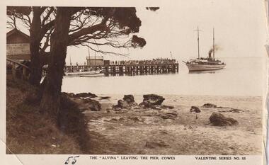
Part of collection donated to the Museum by Mr. Bernard Grayden. 1975View of "Alvina" at Cowes Pier, and Cowes Beach showing sign about Beach Buildings on building at leftThe "Alvina" leaving the Pier, Cowes. Valentine Series No. 55local history, maritime technology, boats documents, postcards, jetties, vessels, cowes, phillip island, sepia postcard, alvina, beach, bernard grayden -
 Bendigo Historical Society Inc.
Photograph - WES HARRY COLLECTION: COLOURED PHOTOGRAPH OF BOY AT THE BEACH BY IRVING HARRY
Coloured photograph of a boy at the beach Undated, beach & boy unspecified Photographer, Irving hrry noted on rearIrving harry -
 Greensborough Historical Society
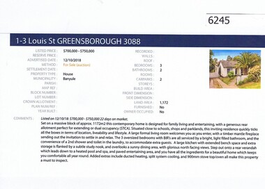
Advertising Leaflet, Barry Plant Greensborough, 1-3 Louis Street Greensborough, 12/10/2018
Real estate advertisement for 1-3 Louis Street Greensborough, 3 bedroom house. Originally listed by Barry Plant, this property was sold by Nelson Alexander on 10/11/2018 for $770,000. Previous sales: November 2011 for $500,000; July 2007, $391,700; September 2003, $350,000; March 2000, $214,300 and March 1988 for $78,000.Real estate advertisement black text and colour photographlouis street greensborough -
 Greensborough Historical Society
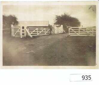
Photograph, Railway Gates at Grimshaw Street Greensborough, 1930c
Two women are standing at the railway crossing gates, ready to open or close the gates [Possibly Iredale family?]. Originally thought to be the rail crossing at Grimshaw Street and Old Greensborough Road. In 2023, there is doubt that this is the case due to the double rail line and building in background. Please contact the Society if you have any idea where this is located.Copy of photo of railway gates. Sepia.On back: "Godwill from Val Wilson"railway gates, rail crossing, iredale -
 Greensborough Historical Society
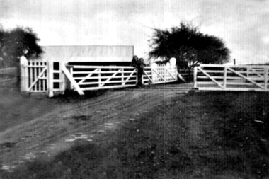
Photograph - Digital Image, Grimshaw Street Railway Gates and Crossing Greensborough, 1930c
Two women are standing at the railway crossing gates, ready to open or close the gates [Possibly Iredale family?]. Originally thought to be the rail crossing at Grimshaw Street and Old Greensborough Road. In 2023, there is doubt that this is the case due to the double rail line and building in background. Please contact the Society if you have any idea where this is located.Digital copy of black and white photograph.rail crossing, iredale -
 Stawell Historical Society Inc
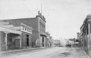
Photograph, C. Herbert Photo, Upper Main Street Stawell c1880, 1880s
Upper Main St. Looking East (Herbert Photo) Businesses are the Cash Store, J. Webb, J Allingham Draper, Chadwicks Draper, Commercial Hotel. Two Story Oriental Bank Building / O'Driscoll solicitors. Horse drawn cart in street. On right is the side of Mechanics Institute, R H Wadsworth Watchmaker. c 1880's. Victorian Views. C. Herbert, Photo. Stawell 1878streetscape, businesses -
 The Beechworth Burke Museum Research Collection
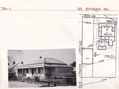
Card (Series) - Index Card, George Tibbits, 33 Bridge Street, Beechworth, 1976
George Tibbits, University of Melbourne. Faculty of Architecture, Building and Town & Regional PlanningIndex system that support the research for Beechworth : historical reconstruction / [by] George Tibbits ... [et al]Arranged by street names of BeechworthEach index card includes: street name and number of property, image of property, allotment and section number, property owners and dates of ownership, description of the property according to rate records, property floor plan with dimensions.beechworth, george tibbitsbeechworth, george tibbits -
 Eltham District Historical Society Inc
Photograph - Colour Print, Shire of Eltham, Quinn Estate, Sackville Street, Montmorency, c.1983
Looking northeast near 107 on left and 118 on right, intersection with Riverina Road on left at corner and Bolton Street around bend to right of image. Image dated between similar images of known dates being Sep 1982 prior to road construction works and May 1983 when kerb and channel/sealing works completed.1983, footpaths and gutters, montmorency, private street scheme, quinn estate, road construction, road drainage, road sealing, sackville street -
 Melbourne Tram Museum
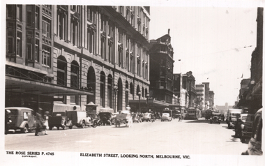
Postcard, Rose Stereograph Co, "Elizabeth Street looking north Melbourne", c1945
Rose Series postcard No. P 4745, titled "Elizabeth Street looking north Melbourne", looking north from about Little Collins St. Has a W2 class tram in the distance with a wartime strip on the rear cabin, a W5 alongside. In the photo is the State Savings Bank of Victoria building, and in the far distance is the then-new Royal Melbourne Hospital.Yields information about Elizabeth St. near the intersection with Little Collins St.Postcard - printed real photograph with Rose Stereograph Co. name on the rear. Unused.trams, tramways, w2 class, w5 class, elizabeth st, state savings bank -
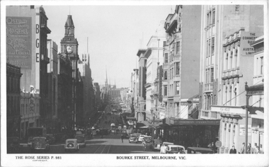 Melbourne Tram Museum
Postcard, Rose Stereograph Co, "Bourke Street Melbourne Vic", c1940
Rose Series postcard No. P 981 titled "Bourke Street Melbourne Vic,". The photo looks east from Queen St. Several cable trams are in the view. There are signs for Osram lamps and valves, a car park, BGE, Film House, Commercial Bank and Thomas Evans Pty Ltd. See item 8076 for a similar image.Yields information about Bourke St c1940.Postcard - printed real photograph with Rose Stereograph Co. name on the rear.trams, tramways, cable trams, bourke st -
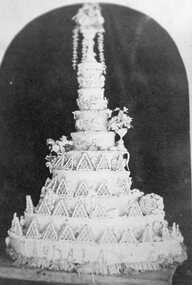 Stawell Historical Society Inc
Photograph, Magdala Cake, baked at Victoria Bakery in Patrick Street by Mr J. Walker 1868-1881
The great Magdala Lottery Cake Baked at Victoria Bakery Patrick Street by Mr J. Walker. Initially made to celebrate the official opening of the Magdala Mine Sept 15 1868 Then made yearly it was sold in pieces with embedded gold or silver coins as prizes. Photo given to Janet Hooper by Mrs Ellen McClure about 1990Large multi-tiered iced cake with Magdala written around bottom tierMagdalastawell, streetscape -
 Federation University Historical Collection
Photograph (black & white), M.B. John Brass Foundry Workers, 1927
In 1896 M.B. John started the Ballarat Brass Foundry in Armstrong Street South on land leased from the Welsh Church. See http://bih.ballarat.edu.au/index.php/Ballarat_Brass_Foundry#BackgroundTwo black and white photographs of MB John Brass Foundry Workers at their Armstrong Street factory. When joined together one large panoramic view is made, which also includes the gates of the Ballarat Gaol. Three men standing to the far right are members of the John family. john valves, mb john, tom bawden, ballarat gaol, m.b. john, morgan b. john, morgan bevan john, valves, engineering, lydiard street south, ballarat -
 Eltham District Historical Society Inc
Document - Folder, Ron F. McCormack, Appeal against Eltham Shire Permit granted for a propsed Youth Enterntainment Centre, 41-43 Were Street, Montmorency, 1993-1994
In 1993 Eltham Shire Council issued a permit to Michael Muzur, Terry Lant and Andrew McMillan to redevelop the former Montmorency Theatre/Bingo Hall at 41-43 Were Street as an alcohol-free youth entertainment centre. Ron McCormack, retired former JP on behalf of 41 Joint Appellants consisting of local residents and traders successfully lobbied the community and won an Appeal to have the permit cancelled as unsuitable development. The Administrative Appeal Tribunal found that the proposed development came withing the Eltham Planning Scheme definition of an 'amusement parlour' and that the playing of pool an amusement machines would be the focus of the centre and unlikely to attract older age groups. The tribunal was not satisfied the applicants had sufficient knowledge or where with all required for the successful running of this type of operation. With respect to the objectors, the Tribunal did not accept that a responsibly managed and attractive amusement parlour could not coexist near the adjoining residential area and without detriment to the commercial centre. At a Council meeting on June 7, 1994 councillors requested a report outlining criteria to be used to assess planning applications for youth entertainment venues given the Tribunal's view that a poorly managed facility in a small neighbourhood shopping centre, particularly in such close proximity to a residential area would not only have the potential to increase perceived youth problems, but could jeopardise the prospects of future proposals. Ron McCormack moved to Montmorency from Coburg in the early 1980s and from then sat on the bench at Eltham Courthouse when Police requested assistance out of hours, until the eventuial closure of the Courthouse. montmorency theatre, montmorency bingo hall, 41-43 were street, youth entertainment centre, eltham shire council, planning permit, administrative appeals tribunal, ron f mccormack -
![Map, Plan of Town Allotments Bacchus Marsh [1891-1897]](/media/collectors/5e461d8021ea67224c82f2a1/items/66acc1c90c778f9f64a3daec/item-media/66acc3990c778f9f64a3e09b/item-fit-380x285.jpg) Bacchus Marsh & District Historical Society
Bacchus Marsh & District Historical SocietyMap, Plan of Town Allotments Bacchus Marsh [1891-1897]
This plan of town allotments in Lerderderg Street and Bennett Street also includes the location of many of the buildings, shops, businesses and houses which were present in the retail and business area of Bacchus Marsh in the 1890s. The precise date of the plan is not known but it must be sometime between 1891 and 1897. The Post Office and the Wesleyan Church are both shown on this plan. Both of these were constructed in 1890. The plan does not show the Baptist Church in Main Street which was constructed in 1898. Hence the date is sometime between 1891 and 1897.This plan of Bacchus Marsh is one of the most detailed visual representations of the location of shops, businesses and houses in the central part of Bacchus Marsh. It provides very precise locations of most of the shops and houses in the town in the 1890s. A single page paper plan showing allotments of land fronting Lerderderg and Bennett Street. Buildings, businesses and houses along most of the streets are identified by hand written annotations. Streets identified on plan: Lerderderg Street - Bennett Street - Main Street - Gell Street - Young Street - Graham Street. Physical boundaries of the map are: North border - Lerderderg Street - South border - Main Street - West border Gell Street - East border - Young Street. The plan is pasted into a bound volume containing 76 maps or plans in total. bacchus marsh victoria maps, shops bacchus marsh -
 City of Kingston
Pamphlet - Colour, Farrow Falcon Press, Printers, Ozone Estate, Bluff Road, Hampton, c.1940
Sales plan for land in the suburb of Hampton (Highett), bounded by Bluff Road, Wickham Road, Peterson Street and June Street. Includes Morley Street, Follett Avenue, and Parrett StreetThe developing urban area of Highett within the City of Kingston. This land sale pamphlet illustrates the subdivision of land within the municipality and the changing demographic of the district as new houses are constructed close to infrastructure.Colour pamphlet advertising for private sale the Ozone Estate, Bluff Road Hampton. Incorporates a map of the estate bordered by Bluff Road, Wickham Road, June Street and Peterson Street including Morley Street, Follett Avenue and Parrett Street.Handwritten in grey pencil on reverse: Ozone Printed in purple ink on front top right-hand corner: Vendors are - Leslie Harcourt MacGowan, Esq / Neerim Road, Caulfield / & / Arthur Alfred Parrett, Esq / 311 Flinders Lane / Melbourneland sales, estate, hampton, highett -
 City of Kingston
Pamphlet - Colour, Farrow Falcon Press, Printers, Ozone Estate, Bluff Road, Hampton, c. 1940
Sales plan for land in the suburb of Hampton (Highett), bounded by Bluff Road, Wickham Road, Peterson Street and June Street. Includes Morley Street, Follett Avenue, and Parrett StreetThe developing urban area of Highett within the City of Kingston. This land sale pamphlet illustrates the subdivision of land within the municipality and the changing demographic of the district as new houses are constructed close to infrastructure.Colour pamphlet advertising for private sale the Ozone Estate, Bluff Road Hampton. Incorporates a map of the estate bordered by Bluff Road, Wickham Road, June Street and Peterson Street including Morley Street, Follett Avenue and Parrett Street.Handwritten in grey pencil on rear: Ozone Estateland sales, estate, highett, hampton -
 Federation University Historical Collection
Book of sheet music, Stainer & Bell Ltd, 'The Rainbow, A Tale of Dunkirk' by Thomas Wood, brass band arrangement by Frank Wright, approx 1950
This music was played for the Grand Armistice Concert of the 11th November 1951, with Frank Wright as the conductor and arranger of the music for brass bands. Frank Wright was a renown resident of Smeaton, where he was born on 2 August 1901. He lived at Laura Villa, and attended Smeaton State School. His father William was a gold miner and his mother's name was Sarah. Their family won many singing and instrumental awards. Frank was tutored by Percy Code and was awarded a gold medal for the highest marks in the ALCM examinations in the British Colonies at the age of seventeen years. He became the Australian Open Cornet Champion by the age of eighteen. A year later, Frank conducted the City of Ballarat Band, and later the Ballarat Soldiers’ Memorial Band. He formed the Frank Wright Frisco Band and Frank Wright and his Coliseum Orchestra. These bands won many South Street awards, and Frank as conductor won many awards in the Australian Band Championship contest. In 1933 Frank Wright sailed to England to conduct the famous St Hilda’s Band and was later appointed Musical Director of the London County Council, where he organized many amazing concerts in parks, in and around the London district. He was made Professor of Brass and Military Band Scoring and conducted at the Guildhall of Music and Drama. Frank was often invited to adjudicate Brass Band Championships around Europe, in Australia, including South Street and in New Zealand. The Frank Wright Medal at the Royal South Street competition is awarded to an individual recognized as making an outstanding contribution to brass music in Australia. Two printed copies of sheet music with buff coloured covers. They are of 'The Rainbow, A Tale of Dunkirk', by Thomas Wood with brass band arrangement by Frank Wright. One is for Solo B flat cornet and the other is for 3rd B flat cornet.On the front covers the title is printed in pen, as is the designated instrument. Also stamped underneath the title is Stainer & Bell, Lts., 89 Newman Street, London, W.1.frank wright, brass bands, sheet music, the rainbow, a tale of dunkirk, grand armistice concert, cornet music -
Glenelg Shire Council Cultural Collection
Photograph - Sheet of 2 contact prints from glass plate negatives, 1960-1970
Sheet of 2 contact prints from glass plate negatives. Each Print measuring 11.8 x 16 cm Top: Close up of front of Portland Post Office, corner Bentinck and Cliff Streets. Horse and buggy at right, several people standing in front of Post Office. Bottom: Dutton Way beach looking towards Portland. Road along top of beach, fenced off from beach. Horse tethered to fence. -
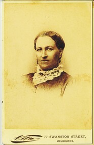 Bendigo Historical Society Inc.
Photograph - HARRIS COLLECTION: FEMALE PHOTO
Black & white portrait woman, parted drawn back hair style. Lace collar with Vic mourning brooch. Earrings. Vita 77 Swanston Street, Melbourne printed on front. Reverse. Printed in Gold 'From the Vita Portrait Studio. Circular printed stamp contains, S Calvert, 77 Swanston Street, Melbourne, Artist Manager around margin.S Calvert, 77 Swanston Street Melbourne.photograph, person, female -
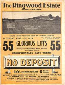 Ringwood and District Historical Society
Pamphlet - Land Auction Brochure, The Ringwood Estate - Second Sub-Division, Ringwood, Victoria - 1919
Double sided bi-fold leaflet advertising subdivision site, layout of streets and allotments, summary of local features and services and terms of sale. Auction Saturday June 14th, 1919. 55 Lots. Subdivision includes Warrandyte Road, Tamar Street, Mersey Street and Derwent Street. Property Sales - Dunlop & Hunt Home Builders Ltd., 317 Collins Street, Melbourne, Tels 10104-10105. Agents - J.B. McAlpin, Tel. Ringwood 7. Auctioneers - Sydney T. Haynes & Co., 60 Queen Street, Melbourne, Tel. 3400. Solicitors - Hodgson & Finlayson, 360 Collins Street, Melbourne. Inset photographs of local views including existing 4-roomed bungalow on Lot 37 Tamar Street. -
 Eltham District Historical Society Inc
Document, Samantha Westbrooke Pty Ltd et al, 2 Bell Street, Eltham: Cultural Heritage Significance Assessment & Heritage Guidelines for Future Use & Development, 2012
Prepared for Nillumbik Shire Council by Samantha Westbrooke Pty Ltd in association with Peter Mills PhD, Architectural Historian and Roark Muhlen-Schilte, Archaeologist. Covers history of early market gardening in Eltham with the commencement of European settlement in the late 1830s. The site for the village of Eltham was surveyed in 1851 and the Township Plan shows that the property is made up of Lots 7 and 8 which were sold at auction in June 1852 to M. O'Shea. The history of the Bell Street property is closely tied to the West family from the 1860s to 1930s; the earliest rate books for Eltham show William West farming in El;tham in 1864. In the aerly 1930s ownership of the creek side was transferred from the west family to the Fabbro family who shortly afterwards were impaced by the 1934 Diamond Creek flooding. Guido Fabbro relocated the original West home further up the hill and built a new Italianate style modern home in situ. The Fabbro family farmed the property. In 1993/4 Eltham Council acquired the creek-side market garden blocks to the south of 2 Bell Street which was recconceived in 1998 as the Barak Bushland Reserve. The Fabbro house was demolished shortly after and the lots were sold to a developer in 1994. The large steel shed now present on the 2 Bell Street property dates from soon after this sale.26 A4 pages color printcultural heritage significance assessment, peter mills, samantha westbrooke pty ltd, shire of nillumbik, 2 bell street, eltham, market gardening, west family, fabbro family, land use, barak bushland reserve, heritage assessment -
 Federation University Historical Collection
Photograph - Photograph - Black and White, Sarah Wright at 214 Armstrong (North) Street, 1928, 1928
Sarah Wright was married to a gold miner named William. They lived at Laura Villa, Smeaton. Their family won many singing and instrumental awards. Frank Wright their son was born and attended Smeaton State School and was a renown resident of Smeaton. Frank was tutored by Percy Code and was awarded a gold medal for the highest marks in the ALCM examinations in the British Colonies at the age of seventeen years. He became the Australian Open Cornet Champion by the age of eighteen. A year later, Frank conducted the City of Ballarat Band, and later the Ballarat Soldiers’ Memorial Band. He formed the Frank Wright Frisco Band and Frank Wright and his Coliseum Orchestra. These bands won many South Street awards, and Frank as conductor won many awards in the Australian Band Championship contest. In 1933 Frank Wright sailed to England to conduct the famous St Hilda’s Band and was later appointed Musical Director of the London County Council, where he organized many amazing concerts in parks, in and around the London district. He was made Professor of Brass and Military Band Scoring and conducted at the Guildhall of Music and Drama. Frank was often invited to adjudicate Brass Band Championships around Europe, in Australia, including South Street and in New Zealand. The Frank Wright Medal at the Royal South Street competition is awarded to an individual recognized as making an outstanding contribution to brass music in Australia. Laura Ritchie was his sister.Black and white photograph of a woman in a long dark skirt and light cardigan sitting on a chair with a pillow behind her back. The chair is on the verandah of a brick house. The woman is Sarah Wright and the house belongs to her daughter Laura Ritchie at 214 Armstrong St Nth, Ballarat.Written in pen on the back May 1928. Written in pencil 214 Armstrong St Northsarah wright. frank wright, laura ritchie, armstrong street, ballarat -
 Surrey Hills Historical Society Collection
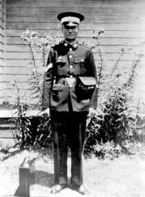
photograph, Mr Joseph George of 26 Scheele Street, air raid warden
Mr Joseph George of 26 Scheele Street Pictured as an Air Raid Precautions Officer during the 1939 – 1945 war. ARP officers controlled the areas around their homes to check on tell-tale lights showing in the ‘brownout’ conditions and advising on the black-out of homes. Street lights were dimmed and screened downwards and Joseph’s daughter Marie remembered sewing black Italian cloth curtains to hang over the windows. Joseph taught adult first aid classes in local schools, church halls and at The Surrey Dive. Joseph conducted his practical training sessions at the Quarry in Grovedale Road, in case they had to deal with an emergency in such a site. Joseph (Joe) and wife Emily Ruth were English migrants; they bought their home in Scheele Street in 1919. Daughter Marie was born in 1914 when they are listed in the electoral roll at 'Hasland', Croydon Road, Surrey Hills; his occupation is given as a boilermaker. Emily (nee Sturgess) - d 15 November, 1960; buried Box Hill Cemetery - M-199A-0034 along with daughter Marie. Possible birth c Oct 1880, Birmingham (not confirmed); marriage to Joseph George c Jan 1905, Chesterfield, Derbyshire. The donor was his daughter, Marie, who was a school teacher and was on the staff at Chatham Primary School for a number of years. She died in February 1989.A black and white photograph of a man in uniform standing in a garden, with a small case beside him.(mr) joseph george, surrey hills, mont albert, scheele street, clothing and dress, uniforms, world war, 1939-1945, air raid wardens -
 Surrey Hills Historical Society Collection
Photograph, Richard and Annie Bate at 'Camelford', 7 Norris Street, Surrey Hills, c1914/1915
Photo was taken in front of the front door of 'Camelford', 7 Norris Street. The presence of the red cross suggests that it was taken during the First World War. Two of the couples' surviving sons served in the war - Frederic George Bate (SERN 1945); Richard Alfred Bate (SERN 695); the third was rejected because he had lost a finger in an accident. Richard Bate came to Australia in 1868 from Cornwall - the house was named after the town there. He was a cabinetmaker and settled in Angaston, SA for a year before coming to Melbourne where he worked as a builder. He built ‘Avondale’, 176 Union Road (dem.) circa 1883 as a display home for the Davies family, subdividers of the first land auction in Surrey Hills. He built many houses including his retirement home at 7 Norris Street (demolished after 2000). In the 1880s Richard also built the Shire Hall in Station Street Box Hill, replaced in 1934 by the Box Hill Town Hall. Two of his sons were also carpenters. Richard died in 1937 aged 93 and his wife Annie Matilda died in 1935 aged 83; both are buried in Burwood Cemetery. House was rented out until probate was settled. Occupied in 2000 by Julie Ellis. REF: Letter to Julie Ellis from Jack Bate of Mildura, grandson of Richard and Annie Bate, dated 29/2/2000.A black and white photocopy of a photograph of a man dressed in a suit, standing beside a lady, seated, wearing a long sleeved, light coloured blouse and a long ankle length skirt. They are in front of a front door with lead light windows.mr richard bate, mrs annie bate, norris street, house names, camelford, avondale, union road, box hill shire hall, builders, ms julie ellis, davies family, annie matilda bate, richard alfred bate, frederic george bate, burwood cemetery, jack bate -
 Federation University Historical Collection
Photograph, Ballarat Teachers' College, 1946, 1946 and 1996
The Ballarat Teachers' College was established after the Victorian State Government and the State Education Department decided to establish two provincial teachers' colleges, at Ballarat and Bendigo. On 04 May 1926 W.H. Ellwood (Principal), Miss A. Bouchier, and Mr A.B. Jones, welcomed the first enrolment of 61 students to undertake the one year course. In 1927 the College moved to the former Ballarat East Town Hall in Barkly Street, which was remodelled for their use. It closed in December 1931 due to the Great Depression. In 1946 Ballarat Teachers' College reopened and relocated to the Dana Street State School. It was originally planned to open as a women's college, for whom the residence at 130 Victoria Street was purchased, but the decision was made to admit resident men from Ballarat. Mr T.W. Turner was appointed as Principal in 1951 and directed the introduction of a two year course for the Trained Primary Teachers' Certificate. The former one year course was terminated at the end of 1951. In 1958 the College was relocated to a custom built facility at Gillies Street, in close proximity to the Ballarat Botanical Gardens. Numbers increased with the introduction of the Trained Infant Teachers' Certificate course under the guidance of Mary Egan. With the introduction of a three year Diploma Course in 1968 accommodation became cramped. The introduction of the Diploma of Teaching (Primary) led to the Trained Infant Teachers' Certificate being discontinued in 1969, and the end of the Trained Primary Teachers' Certificate in 1969. Secondary Art and Craft students began studies at Ballarat Teachers' College in 1969 under Mr Ted Doney. In 1971 Mr D. Watson was appointed Principal. The State College of Victoria was proclaimed by Order in Council on 24 July 1973, and Ballarat Teachers' College became a constituent college of the State College of Victoria, and was known as State College of Victoria, Ballarat. By 1975 the College moved to Mount Helen as part of the Ballarat College of Advanced Education. Pre service teachers currently undertake their studies on the Mount Helen Campus of Federation University. ("Ruffians Attempted to Carry of the School Tent: A History of State Education in Ballarat", 1974, p73-4.) .1) Photography of the 1946 class of the Ballarat Teachers' College. The photograph is taken in the grounds of Dana Street Primary School. .2) Reunion photograph of the 1946 class of the Ballarat Teachers' College taken in 1996.ballarat teachers' college, dana street primary school, renunion, dana street state school -
 Federation University Historical Collection
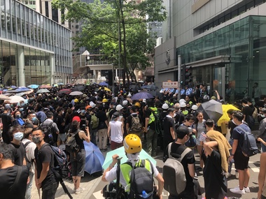
Photograph - Photograph - Colour, Jarrod Watt, Seven police officers stand guard in front of Hong Kong's main police headquarters on Arsenal Street in Wan Chai, 2019, 21/06/2019
Carrie Lam, Hong Kong’s chief executive, had plenty of political support in the territory’s pro-Beijing legislature to pass a bill that would allow extraditions to mainland China. The legislators were set to begin discussing the bill in early June, and intended to vote on it just weeks later. A series of protests took place, and after a June 16 protest saw the largest turnout yet, Ms. Lam made a major concession: She postponed the bill, at least temporarily. It was an undeniable victory for the protesters — but it did little to quell the unrest. Since the bill could later be reintroduced, protesters felt they remained in danger. The police tactics to break up the demonstrations on June 12, including the use of more than 150 tear gas canisters to push protesters far away from the government office, created a new set of demands from the protesters. Now, instead of just calling for the withdrawal of the bill and Ms. Lam’s resignation, they said they wouldn’t be content unless there was an independent investigation of officers’ conduct. They also wanted the release of protesters arrested on June 12, and for the government to rescind its description of the demonstrations as a “riot,” a designation that carries legal significance. None of that has happened. Many analysts say Ms. Lam is unlikely to step down, nor would Beijing accept her resignation if she offered it. She has more wiggle room on the other demands, but has not indicated any willingness to budge. The Hong Kong Protests are a leaderless, digital movement.There is no single leader or group deciding on or steering the strategy, tactics and goals of the movement. Instead, protesters have used forums and messaging apps to decide next steps. Anyone can suggest a course of action, and others then vote on whether they support it. The most popular ideas rise to the top, and then people rally to make them happen. At its best, this structure has empowered many people to participate and have their voices heard. Protesters say it keeps them all safe by not allowing the government to target specific leaders. Their success in halting the extradition bill, which was shelved by the territory’s chief executive, speaks to the movement’s power. Despite the lack of a clear leader, protesters have shown extensive coordination at the demonstrations, having planned the specifics online beforehand. Supply stations are set up to distribute water, snacks, gloves, umbrellas and shields made of cardboard. Volunteer first aid workers wear brightly colored vests. People form assembly lines to pass supplies across long distances, with protesters communicating what they need through a series of predetermined hand signals. Anyone walking in dangerous areas without a helmet or a mask is quickly offered one. No individual can speak on behalf of the protesters, which makes negotiations difficult, if not impossible. (https://www.nytimes.com/2019/07/02/world/asia/hong-kong-protest-explained.html, accessed 07/07/2019) Hong Kong’s amended extradition law would allow the extradition of suspects to mainland China for the first time. Supporters say the amendments are key to ensuring the city does not become a criminal refuge, but critics worry Beijing will use the law to extradite political opponents and others to China where their legal protections cannot be guaranteed. The government claims the push to change the law, which would also apply to Taiwan and Macau, stems from the killing last year of a Hong Kong woman while she was in Taiwan with her boyfriend. Authorities in Taiwan suspect the woman’s boyfriend, who remains in Hong Kong, but cannot try him because no extradition agreement is in place. Under the amended law, those accused of offences punishable by seven years or more in prison could be extradited. The new legislation would give Hong Kong’s leader, known as the chief executive, authority to approve extradition requests, after review by the courts. Hong Kong’s legislature, the legislative council, would not have any oversight over the extradition process. Many Hong Kongers fear the proposed extradition law will be used by authorities to target political enemies. They worry the new legislation spells the end of the “one country, two systems” policy, eroding the civil rights enjoyed by Hong Kong residents since the handover of sovereignty from the UK to China in 1997. Many attending the protests on Sunday said they could not trust China as it had often used non-political crimes to target government critics, and said they also feared Hong Kong officials would not be able to reject Beijing’s requests. Legal professionals have also expressed concern over the rights of those sent across the border to be tried. The conviction rate in Chinese courts is as high as 99%. Arbitrary detentions, torture and denial of legal representation of one’s choosing are also common. Many in the protests on Sunday 09 June 2019 said they felt overwhelmed by a sense of helplessness in the face of mainland China’s increasing political, economic and cultural influence in Hong Kong. Hong Kong’s top political leader is not elected by ordinary voters but by a 1,200-strong election committee accountable to Beijing. Half of its legislature are chosen through indirect electoral systems that favour pro-Beijing figures. Many Hong Kongers also cited the jailing of leaders and activists from the 2014 Occupy Central movement– a 79-day mass civil disobedience movement – as well as the disqualification of young localist lawmakers as signs of the erosion of civil freedoms. Resentment towards China has been intensified by soaring property prices – with increasing numbers of mainland Chinese buying properties in the city – as well as the government’s “patriotic education” drive, and the large numbers of mainland tourists who flock to Hong Kong. Many Hong Kongers are also concerned about China’s growing control over the city’s news media, as they increasingly self-censor and follow Beijing’s tacit orders. https://www.theguardian.com/world/2019/jun/10/what-are-the-hong-kong-protests-about-explainerSeven police officers stand guard in front of Hong Kong's main police headquarters on Arsenal Street in Wan Chai as an estimated one thousand protestors surround on 26 June 2019. Protestors take turns to step up and hurl abuse at the officers, in a protest lasting 6 hours before peacefully dispersing. The protesters chanted 'Release the martyrs' and 'Stop police violence' in reference to violent clashes with police in the days previous. ( https://www.scmp.com/news/hong-kong/politics/article/3016238/hong-kong-police-under-siege-again-protesters-surround)carrie lam, hong kong protests, extraditions, protest, protestors, police, wan chai