Showing 1619 items matching "borough"
-
 Bendigo Historical Society Inc.
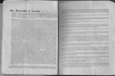
Document - City of Sandhurst, Borough of Eaglehawk and Shire of Marong - conditions for the operation of electric tramways, unsigned but dated 1889, Electric Tramways
Bendigo tramways conditions of operation including fares for a range of trips.City of Sandhurst, Borough of Eaglehawk and Shire of Marong =- conditions for the operation of electric tramways, 1889, for concession, construction, maintenance and working of Electric Tramways along the main cab route from Sandhurst Railway Station to the Town Hall Eaglehawk; and from the Botanic Gardens, White Hills to Kangaroo Flat. The document is not singed or sealed by the municipal parties Document includes a list of fares for a range of journeys on the trams. Document is in good condition, bound with a light cover sand stapled -
 Ringwood and District Historical Society
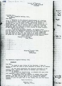
Document, Ringwood Bowls Club- Letter from Town Clerk Ringwood relative to the establishment of a Bowling Green in Ringwood. Dated 7/9/1929
Typed letterLetter addressed to W.W.Cock Esq., Hon Sec Ringwood Bowling Club, giving permission for the Club to have full control of the ground and its assets should the site in Bamford Park be used for a Bowling Green and Croquet Lawns. Signed by A.F.B.Long, Town Clerk, Borough of Ringwood, 7/9/1929. -
 Stawell Historical Society Inc
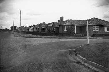
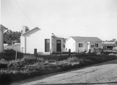
Photograph, Housing Commission House in Dawson Street -- Photo & Newspaper Clipping
The first Housing Commission homes of brick and tiled roof built after WW2 in Stawell Dawson Street c 1950's. Also in the file a Newspaper clipping from News, Saturday, October 11. 1947. "George Mitchell Square" the first Housing Commission homes built in Stawell. George Mitchell was a member of Borough Council for 40 years and Mayor for 4 years. The housing estate was named in his honor. The architects "Buchannan Laird & Buchanan Geelong.Black and white photograph of a street scene. The photograph shows a line of brick houses along the street with timber fences. Four electric power lines are along the street with 2 in the distance. The street also has curb and guttering. The street to the right has a street post with "George Mitchell St" written on the street sign.stawell -
 Port Fairy Historical Society Museum and Archives
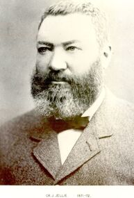
Photograph, Cr J Jellie Shire of Belfast President 1871-72
Councillor James Jellie came to Melbourne from Ireland in 1841 and moved to Belfast in 1843. he then relocated to Warrnambool in 1849 where he worked as a farmer. He later entered into business as an auctioneer, loan and estate agent and valuation and several large properties passed through his hands. He was one of the partners in the auctioneering firm that sold Atkinson’s Crown Special Survey. His municipal activities extended to the Shire of Warrnambool as well as the Borough of Belfast.Black and white portrait government, belfast, president, portrait, shire, municipal, local-government, auctioneer, james jellie -
 Port Melbourne Historical & Preservation Society
Plan - Open drainage channel, cnr Beach Street and Railway Place, Port Melbourne, Frederick William Bull, Principal Surveyor, 1862
Plan for open drainage channel at corner of Beach Street and Railway Place, 1892."Open Channel at Foot of Railway Place":Signed by Frederick William Bull, Principal Surveyorengineering - canals and drainage, engineering department - borough of sandridge, frederick william bull, business and traders - hotels -
 Ringwood and District Historical Society
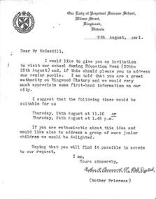
Letter - Our Lady of Perpetual Succour School, Ringwood, Victoria, Guest speaker invitation to Mr. J. McCaskill on History of Ringwood , draft of acceptance response, and students' thank-you letter - 1961
Mr. J. K. McCaskill was a Mayor of Ringwood on several occasions and founder of Ringwood Historical Research Group.1.Typed letter on cream coloured paper to Mr. McCaskill from the Mother Prioress, Mother Bernard, to talk at the school on Ringwood History on 9th. August 1961 2.Hand written copy on cream coloured paper replying to the invitation with the acceptance to talk at the school on 24th. August at 1.45p.m. and signed J McCaskill. 3.Hand written letter written by Marlene Tankard to Mr. McCaskill thanking him for his talk. 4.Unused stationery with Borough of Ringwood Crest on each. -
 Ringwood and District Historical Society
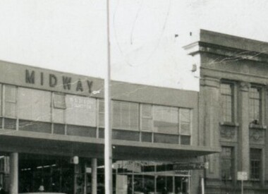
Administrative record, Midway Arcade Construction, Ringwood, Victoria - 1955
Two typewritten pages and ten pages of handwritten notes and sketches - Schedule of materials to be used in the Shopping Arcade at 147 Whitehorse Road, Ringwood, being built for Ringwood Investments Pty. Ltd. Architect - P.E. Jorgensen, Collins House, 360 Collins Street, Melbourne C.1. Consulting Engineer - W.L. Irwin, 441 St.Kilda Road Melbourne. Rubber stamped Borough of Ringwood approval subject to Building Regulations and By-Laws (signed) Building Survyor 24/5/1955. -
 Bendigo Historical Society Inc.
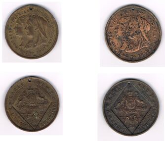
Medal - QUEEN VICTORIA 60 YEARS COMMEMORATIVE MEDALLION X 2, 1837-1897
Queen Victoria 60 years Medallion: Two Medallions issued by the borough of Eaglehawk for Queen Victoria's 60th year of Reign, 1837-1897. Has a picture of Queen Victoria on one side with inscription 'Queen Victoria's 60th Year of Reign 1837-1897' On the back it has the Eaglehawk crest with the motto 'Diet Etmon Droit' inscribed around the crest is Eagle * Hawk .C. Brown Mayor 1897. Both medallions have a small hole punched at the top. Box 625numismatics, medals - commemorative, eaglehawk mayor e.c. brown. queen victoria 60th year reign. eaglehawk crest. 1897 -
 Bendigo Historical Society Inc.
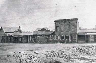
Photograph - VIEW POINT
Black and white copy of original photo by Batchelder, taken in 1861. View point/Charing Cross, looking towards Forest St., View shows H. Joseph's Assay Office, Lunn's furniture warehouse., S.F. Bastard, Victoria House, draper and silk mercer, Langridge's View Point Hotel, Williamson wholesale butcher. A horse drawn wagon laden with timber in centre of photo. Batchdelder signature in bottom rh corner. Batchelder photos were commissioned by the Sandhurst Borough Council in 1861.Batchelderplace, streetscape, view point -
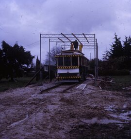 Ballarat Tramway Museum
Slide - 27 mm sq slide/s - set of 4, Lilian Butler, shed being built at Victory Park for tram 18, Oct. 1971
Yields information about the transfer of tram 18 to Victory Park Sebastopol and the handover including the shelter built for it.Set of 4 Kodachrome white cardboard slides and one AGFA blue and white plastic mount slides of the shed being built at Victory Park by the Borough of Sebastopol, October 1971 to cover tram 18 and of the hand over ceremony - see also Reg Item 2909. .1 - Shed being erected over the tramcar. .2 - hand over ceremony .3 - fence placed around the tram .4 - completed work. Photo from the collection of Lilian Butler.ballarat, tramways, trams, tram disposal, sebastopol, borough of sebastopol, victory park, albert st, moving trams, tram 18 -
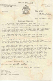 Ballarat Tramway Museum
Document - Letter/s, The Courier Ballarat, 13/09/1971 12:00:00 AM
Letter from the City of Ballaarat - 13 Sept. 1971 inviting people to attend a civic reception to be held in the Reception Room at the City of Ballaarat on 20 Sept. 1971 following the closure of the tramways the previous day. Noted the 84 years of service, the takeover of the tramways by the SEC in 1934, welcome to the newly appointed Chairman of the SEC, Mr. N. R. White. Mayor Cr. J.A. Chisholm with the support of Cr. N.F. Donald, the Mayor Sebastopol Borough Council. Invitation addressed to Mr. L. Walker."Mr. L. Walker" in black ink.trams, tramways, closure, city of ballaarat, civic functions, secv -
 Kew Historical Society Inc
Map, MMBW, MMBW Plan No.64 Kew & Heidelberg, 1900-1910
The Melbourne and Metropolitan Board of Works (MMBW) was established by an act of the Victorian Parliament in 1890 to prepare for and to implement a sewerage and water reticulation system across what was then inner Melbourne, its surrounding and middle distance suburbs, including Kew. The MMBW was disbanded in 1991.The map collection of the Kew Historical Society has at its core the historic maps assembled and originally stored in the City Engineer's Department of the City of Kew. These include maps in a number of scales. The vast majority of maps were produced by the MMBW in the first two decades of the twentieth century, and are solid working maps, backed by linen for durability. These maps are historically significant to Kew, the City of Boroondara and to the history of the development of state utilities in Victoria. A number of the Kew maps have additional details added by former municipal officers, including the levels reached by various floods. As these were working documents, information was added to them long after the period of their initial production and distribution.Early map of part of the Borough of Kew, created in the first decade of the twentieth century, at a scale 160 ft to 1 inch. The map covers what was then the northern most part of Kew, bordered on its north and west by the Yarra River, in the East by Connor's Creek and by the Asylum in the south. The map shows the extent of urban development by that time, prominent institutions and the outlines of built structures in the municipality. Contour lines and historic flood levels were added in ink to the map at a later stage.MELBOURNE AND METROPOLITAN BOARD OF WORKS / PLAN NO. 64 / KEW & HEIDELBERGmelbourne & metropolitan board of works, mmbw maps, mmbw plans, borough of kew, cartography -
 Kew Historical Society Inc
Map, MMBW, MMBW Plan No.65 Kew & Heidelberg, 1900-1910
The Melbourne and Metropolitan Board of Works (MMBW) was established by an act of the Victorian Parliament in 1890 to prepare for and to implement a sewerage and water reticulation system across what was then inner Melbourne, its surrounding and middle distance suburbs, including Kew. The MMBW was disbanded in 1991.The map collection of the Kew Historical Society has at its core the historic maps assembled and originally stored in the City Engineer's Department of the City of Kew. These include maps in a number of scales. The vast majority of maps were produced by the MMBW in the first two decades of the twentieth century, and are solid working maps, backed by linen for durability. These maps are historically significant to Kew, the City of Boroondara and to the history of the development of state utilities in Victoria. A number of the Kew maps have additional details added by former municipal officers, including the levels reached by various floods. As these were working documents, information was added to them long after the period of their initial production and distribution.Early map of part of the Borough of Kew, created in the first decade of the twentieth century, at a scale 160 ft to 1 inch. The map covers what was then the south central part of Kew, bordered on its north by Malmsbury Street, in the west by Florence Avenue, in the south by Barkers Road, and in the east by Princess Street. The map shows the extent of urban development by that time, prominent institutions and the outlines of built structures in the municipality. Contour lines were added in ink to the map at a later stage.MELBOURNE AND METROPOLITAN BOARD OF WORKS / PLAN NO. 65 / KEW & HEIDELBERGmelbourne & metropolitan board of works, mmbw maps, mmbw plans, borough of kew, cartography -
 Kew Historical Society Inc
Map, MMBW, MMBW Plan No.66 Kew, 1900-1910
The Melbourne and Metropolitan Board of Works (MMBW) was established by an act of the Victorian Parliament in 1890 to prepare for and to implement a sewerage and water reticulation system across what was then inner Melbourne, its surrounding and middle distance suburbs, including Kew. The MMBW was disbanded in 1991.The map collection of the Kew Historical Society has at its core the historic maps assembled and originally stored in the City Engineer's Department of the City of Kew. These include maps in a number of scales. The vast majority of maps were produced by the MMBW in the first two decades of the twentieth century, and are solid working maps, backed by linen for durability. These maps are historically significant to Kew, the City of Boroondara and to the history of the development of state utilities in Victoria. A number of the Kew maps have additional details added by former municipal officers, including the levels reached by various floods. As these were working documents, information was added to them long after the period of their initial production and distribution.Early map of part of the Borough of Kew, created in the first decade of the twentieth century, at a scale 160 ft to 1 inch. The map covers what was then the south eastern part of Kew, bordered on its north by Adeney Avenue, in the west by Sackville Street, in the south by Barkers Road, and in the east by Burke Road. The map shows the extent of urban development by that time, prominent institutions and the outlines of built structures in the municipality. Contour lines were added in ink to the map at a later stage.MELBOURNE AND METROPOLITAN BOARD OF WORKS / PLAN NO. 66 / KEW melbourne & metropolitan board of works, mmbw maps, mmbw plans, borough of kew, cartography -
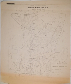 Bendigo Historical Society Inc.
Map - CAMPBELL COLLECTION: BENDIGO AND DISTRICT MAPS, 1982
Map. Forest Commission Victoria, Bendigo Forest District, Greater Bendigo Area. Shire of Marong, Sailors Gully, Epsom, Borough of Eaglehawk, Jackass Flat, White Hills, California Gully, Shire of Huntly, Maiden Gully, Long Gully, North Bendigo, Bendigo East, City of Bendigo, West Bendigo, Kennington, Shire of Strathfieldsaye, Flora Hill, Quarry Hill, Golden Square, Kangaroo Flat, Spring Gully. Prevention Strategy Plan. Base prepared 1982.map, bendigo, forest district -
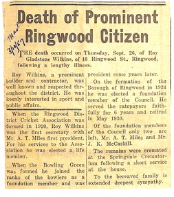 Ringwood and District Historical Society
Newspaper - Obituary, Death notice for Ringwood resident, Roy Gladstone Wilkins - 26 September, 1957
Local newspaper clipping - Ringwood Mail, 3/10/1957. Death of Prominent Ringwood Citizen.Roy Wilkins, a prominent builder and contractor, was well known and respected throughout the district. He was keenly interested in sport and public affairs. First secretary and life member of Ringwood District Cricket Association. Foundation Bowls Club member and president. Foundation member of Borough of Ringwood when Council formed in 1924. -
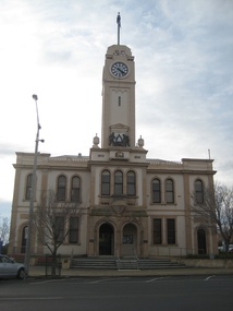 Victorian Interpretive Projects Inc.
Photograph - colour, Clare Gervasoni, Stawell Town Hall, 13/08/2012
Stawell was known as a gold mining town. The Stawell Town Hall clock and tower were erected by Mrs Norman Kelly in memory of her late father Cr George Barnes, a councillor of the Borough of Stawell over a period of 47 years, and also her mother, the late Emma Barnes. 10 May 1939. The animated mining scene on the Stawell Town Hall was incorporated into the tower from a bequest by Emma Kelly. It was officially opened by Sir Henry Bolte on 06 October 1969.Colour photograph of the Stawell Town Hall, and details such as the mining logo and plaques.stawell, stawell town hall, mining, george barnes, emma barnes, emma kelly, henry bolte -
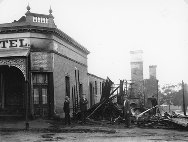 Stawell Historical Society Inc
Photograph, Mr Gustav Mahnke’s Bakery Shop on the corner of Main & Wimmera Streets Stawell -- burnt out by fire 1922, 1922
Ruins of Gustav Mahnke’s Bakery Shop Corner of Main Street and Wimmera Street Stawell destroyed by fire 1922. The Chimneys left standing would have belonged to the ovens. Firemen Left R. Chapman - extreme right Alf Pickering , inspecting damage. The Post Office Hotel and the destroyed bakery on the corner of Main and Wimmera Streets. Gustav Mahnke, a German, was a borough Councilor, Mayor for three successive terms - 1904-07. Note extreme right in the backgorundbehind trees - Stawell Baths.B/W. Photograph of the ruins of a burnt building, next to a Hotel with four men.Part of a sign reading "TEL"stawell business streetscape -
Glen Eira Historical Society
Article - LONG, JOHN
This file contains two items: 1/A photocopy (less than A5 size) detailing Robert Marriott and John Long from their arrival in Victoria. It notes that both became Councillors in the City of St. Kilda and plus where they lived. Copied from "Marriott Family" -1948A which is a full page of typed information relating principally to the Marriott Family. 2/Photocopied photo from ‘Sand, Swamp and Heath’ of Caulfield Borough Council, 1901. Includes John Long, page 24.marriott robert, long john, gold, caulfield, councillors, st. kilda, hawthorn road, alexander hospital, hospitals, flowers street, laura street, glenhuntly road, marriott john, bambra road, field street -
 Melbourne Tram Museum
Legal record, Malleson England Stewart, Essendon Tramway system, 9/1904 - 6/1906
Set of 7 typed, some bound foolscap documents associated with the agreement with the promoter for the construction of the Essendon Tramway system during 1904. Only the top page has been imaged. .1 - 21 page (top page loose), "The Town of Essendon and The Borough of Flemington and Kensington with A. E. Morgans Esq Agreement" dated 26/9/1904, sets out routes, gauge, motive power, maximum speed, safety, tolls and charges, use, power house, default and various responsibilities. Last page has signature details. .2 - 8 pages bound with a clip, marked "A", dated 26/9/1904, Agreement of Delegation of Morgan's rights to the North Melbourne Electric Tramways and Lighting Co. Ltd. .3 - 15 page bound with a clip, marked "B" dated 26/9/1906, (1904?) agreement of Delegation of Morgan's rights for the transfer of order under Electric Light and Power Act 1896. Dated by the Governor Arthur Talbot 24/10/1904. .4 - 22 pages, bound with a clip, marked "C" copy of agreement annexed to the Deed of Covenant for the purposes of identification. .5 - 7 pages secured with a pin - "Extraction the Government Gazette May 11 1904 - Tramways in the Town of Essendon and Borough of Flemington and Kensington" .6 - approx. 30 pages cotton bound - copies of various Indentures and Covenants between the parties and approved by the Governor in Council. .7 - 9 pages, Deed of Covenant marked "D" between NMETL, A E Morgans, the City of Essendon and the City of Melbourne dated 21/6/1906, refers to the Tramway Act of 1890. Would have been needed following the absorption of the Borough by the City of Melbourne.trams, tramways, nmetl, new tramway, essendon, power station, safety, flemington, kensington -
Ringwood and District Historical Society
Memorabilia, Australian Natives Association, Invitation to Seventh Annual Smoke Social in the Parish Hall, Ringwood, Victoria - 1939
Buff coloured card with gold printingThe President and Committee of the Ringwood Branch (No.309) Australian Natives' Association request the pleasure of the Company of Mayor & Councillors, Borough of Ringwood at the Seventh Annual Smoke Social in the Parish Hall, Ringwood, Monday, 4th September, 1939 at 8 p.m. RSVP to O. R. Lynes, Vernon St. Croydon by Monday, 21st August. -
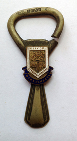 Warrnambool and District Historical Society Inc.
Souvenir - Souvenir Bottle opener, Mid 20th century
Warrnambool, established in 1847, became a Municipality in 1856, a Borough in 1863, a Town in 1883 and a City in 1918. This bottle opener has most probably been produced by the City of Warrnambool for promotional purposes and may have been given as gifts to notable visitors. The logo used is a version of the original ‘By These We Flourish’ seal which was first adopted by the Council in 1856. On the top portion is the Royal Coat of Arms. On the lower section is a sailing ship and a sheaf of wheat. The seal was designed by John Macdonald, a local schoolteacher and auctioneer. This bottle opener is of some interest as a promotional item produced for the Warrnambool City Council. It may be useful for display. This is a bottle opener made of electro-plated nickel silver. It has a badge with blue, white and gold enamelling with the old logo of the City of Warrnambool. The ring is broken – cut through at one end. ‘E.P.N.S.’ ‘City of Warrnambool’ ‘By These We Flourish’ city of warrnambool, bottle opener, souvenir household items, warrnambool souvenirs -
 Warrnambool and District Historical Society Inc.
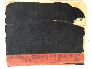
Book, Subdivision No 1 to 1420, 1930s
This is an exercise book listing subdivisions in Warrnambool from 1935 to 1977. There are 1420 entries. It gives details of the subdivisions – plan number, street, section number, allotment number, date, owner, solicitor and Titles Office number. The book is completely filled and today this information would be held in the Warrnambool City Council offices per electronic data storage. Warrnambool, founded in 1847, became a Municipality in 1856, a Borough in 1863, a Town in 1883 and a City in 1918. Subdivisions of land in the city continue to be made regularly for housing and business purposes.This book is of great historic interest because it details the subdivisions in the City of Warrnambool from 1935 to 1977. It shows the continuing growth of the city, particularly after World War Two. It will be a very useful resource for researchers. This is an exercise book with a black cardboard cover and red binding. It contains a list of City of Warrnambool subdivisions from 1935 to 1977. The cover and some of the pages are torn and ragged and the binding has come apart and has been glued together in places. The pages are ruled with blue and red lines. The pages contain handwritten material in black and blue ink. Front Cover: ‘Subdivions(sic), Nos 1 to 1420’ Inside Front Cover: ‘City of Warrnambool Subdivisions’ warrnambool city council, warrnambool subdivisions -
 Halls Gap & Grampians Historical Society
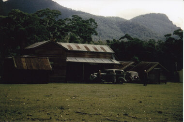
Photograph - Coloured
The main building and chalets were built by E. C. Mitchell of Stawell. He was given a 99 year lease by the shire to build his holiday house at the site of Borough Huts. David and May Mitchell took over ownership of the house and chalets. The women in the photo are May and Isabel Mitchell and the man is David Mitchell. The chalets were called "Flappers Roost", "Bower of Innocence" and "Last Resort". The two copies of the photo are taken from slight closer in and are not as clear and do not show the entire third chalet.The photo shows a collection of old buildings. Two women are standing in front of a car and a man is standing a short distance from them. A second car is parked between the main building and the huts. The building to the far right of the photo is painted in a cream colour and has a tin chimney. The other buildings are three small huts or chalets. Gum trees and a mountain range can be seen directly behind the buildings.buildings, houses -
 Kew Historical Society Inc
Plan, Survey Plan, Park Hill Road, Kew, 1880-1890
The streets identified on the survey plan - Cotham Road, Park Hill Road East, Park Hill Road West in Kew were each gazetted by the Victorian Government in 1865. The hand-coloured survey plan was completed by Holland Loxton, Town Clerk and Surveyor of the Borough of Kew from 1866. The unnamed survey plan includes names of land owners in addition to measurements (2 chains to 1 inch) and streets. Named owners include Webster, Payne and Francom which will enable us to narrow down the creation date of the survey.Handdrawn survey plan by a former surveyor and town clerk of KewHand drawn and coloured survey plan created by Holland Loxton, Surveyor and Town Clerk of Kew, showing land owned by Payne in Park Hill Road, Kew. The plan includes street names, land measurements and land owners.surveys - kew, maps - kew, holland loxton, park hill road - kew, holland loxton -- surveyor, survey plans -- parkhill road -- kew (vic.) -
 Maryborough Midlands Historical Society operating the Worsley Cottage Museum
Trowel and mallet, Circa 1890
The trowel and mallet set was purchased by Mr Swanson, the builder of the Maryborough (Victoria) Railway Station prior to the planned ceremony for the laying of the foundation stone. Duncan Gillies. the Victorian Premier, was to lay the foundation stone, but his government was defeated in the week before the scheduled ceremony. The trowel and mallet set was never used. This set was held by the Maryborough Borough (later City) Council and lay unidentified for almost 120 years until a receipt from the jeweller was discovered. The set was donated to the Maryborough Midlands Historical Society in 2010.Ceremonial trowel and mallet set in brown leather covered presentation case with blue satin lining. Trowel has silver blade with cream handle possibly bone. Mallet cream, possibly bone. H. NEWMAN/Jeweller/MELBOURNE -
 Warrnambool and District Historical Society Inc.
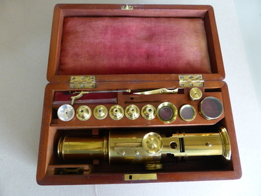
Instrument - Microscope, Microscope - J Aitken, c. 1850
This microscope belonged to James William Manifold Aitkin (1835-1905) who was born in Tasmania and came to Warrnambool in 1852. He was a shopkeeper, produce merchant and flour miller who came to live at the property of Carracoorte, Grasmere in the late 1880s. He was a member of the Warrnambool Municipal Council from 1861 to 1868 and was Chairman of the Borough in 1863 when Warrnambool was declared a town and an early Mayor. The microscope was an improved model of a design by Benjamin Martin, an 18th century instrument maker considered one of the greatest designers and manufacturer of microscopes of his time. This microscope is of great significance because: 1. It is a beautiful object with high antiquarian and scientific interest 2. It has strong local significance as it belonged to James William Manifold Aitkin, a prominent Warrnambool and district businessman and farmer 3. It has social significance as it demonstrates the interest in natural history by the more affluent and educated men of the time. This microscope is in a polished wooden box with a metal lock (no key). The microscope is an English Martin Improved drum microscope (c. 1850) and made of brass. Inside the box there are two divisions, one to house the microscope. The other has a drawer containing six slide samples made of ivory or bone and five glass slides (with the listed material missing) and five other small items. On top of the drawer is a section for the microscope attachments contained in ten small inserts. The ten attachments are made of brass. There are also six items not in any particular inserts. There are two small slots for the pincers and slides etc. The only writings are the names and information on the slidesjames aitkin, microscope, benjamin martin, benjamin martin microscope, warrnambool -
 Stawell Historical Society Inc
Photograph, Eventide Homes in Stawell -- some of the 1 st Homes
Some of the first homes built at Eventide Homes Stawell. These building of a home for the elderly people was first discussed at a Borough Council meeting on 14th April 1948 by councilor E. W. Carra. A public meeting 12th October 1950 preferred the building of home units. From that developed the Eventide homes project. The first unit built, by voluntary labour and mainly furnished from donations was opened 17th August 1955. The Commonwealth Social Serviced Department subsidised the building of units in c 1950 - 1960.Two black and white photographs of small wooden buildings in a group. Dirt road in the foreground. stawell -
 Ringwood and District Historical Society
Photograph, The Crag, 69 Warrandyte Road, Ringwood
1 large black and white photograph, 1 sepia postcard- showing house with picket front fence.Written on back of black and white photograph: "About 69 Warrandyte Road." Written on back of Postcard: "The Crag, 69 Warrandyte Road, Ringwood." Early Borough of Ringwood Rate notices show that Thomas Brierley was the owner of the property from 1938 to 1949. Tenants included Lewis Lampert, Chiropractor, and later a McCann family member. -
 Ringwood and District Historical Society
Administrative record - Borough Of Ringwood 14th August 1950, Constitution of the East Ringwood Reserve Management Committee
The objects of the committee is to act under the authority and subject to control of the Council of the Borough of Ringwood as the Local Board of Management and to act as an advisory consultive and operational Committee, to lay out, and effect improvements and works of beautification, ornamentation and use for the benefit and enjoyment of citizens and to keep and maintain such Reserve in good order and condition and raise funds for improving and mataining such Reserve. The Committee shall consist of two Councillors and Town Clerk and two representatives from each: Football Club, Cricket Club, Tennis Club and Progress Association and 2 Citizens.