Showing 3171 items matching "natural"
-
 Eltham District Historical Society Inc
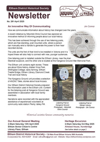
Journal - Newsletter, Newsletter, No. 281 April 2025
Contents: • An Innovative Way Of Communicating by Jim Connor • Next meeting – Annual General Meeting –2:00pm Saturday 12th April 2025; Guest Speaker Greg Burgess • Excursion – Saturday 3rd May – Allwood Neighbourhood House, Hurstbridge • Building a Railway by Peter Pidgeon • George Stebbing (c.1819 – 1896) by Richard Pinn • Gordon Craig Ford – Natural Australian Garden by Marguerite Marshall • Gordon Craig Ford by Jim Connor • Thomas McMurtrie Orr by Peter Van Eeken • Notice: Annual General Meeting – Saturday 12th April 2025 • Experience Eltham Cemetery by Julia DrewThe Shire of Eltham Historical Society was formed in October 1967. The first newsletter of the Society was issued May 1978 and has been published continuously ever since on a bi-monthly basis. With the cessation of the Shire of Eltham in late 1994, the Society's name was revised to Eltham District Historical Society and this name first appeared with issue No. 103, July 1995. The collection of the Society's newsletters provides a valuable resource on the history of the Society's activities, office bearers and committee members, guest speakers and subjects of historical interest pertinent to the former Shire of Eltham and the Eltham District.A4 newsletter distributed to members (Digital and A4 photocopy)newsletter, eltham district historical society -
 Ithacan Historical Society
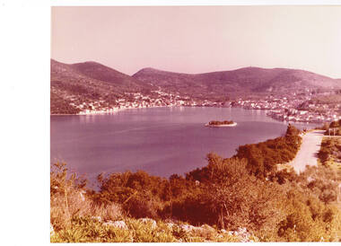
Photograph, Vathi Harbour, Ithaca Greece, c1970s
Vathi is the main town of Ithaca where the municipal offices, local high school, medical centre and other services are located. It is one of the most natural ports in Greece. Ferries from the mainland used to dock at Vathi however, now arrive at the port of Piso Aetos. In middle of the harbour is the tiny islet of Lazaretos where the church of Ag Sotiros (the Saviour) stands. During the period of English rule, Lazaretos functioned as a quarantine station. The buildings erected by the British later served as a prison. However these were destroyed during the earthquakes of 1953 and later demolished. Lazaratos is now popular with young couples who chose to marry in the church. A coloured photograph overlooking the harbour of Vathi, the main town and port on Ithaca. Houses are built around the water's edge and along the lower slopes of the mountains. A small islet, known as Lazaretos, is visible in the middle of the harbour. harbours, vathi -
 Wooragee Landcare Group
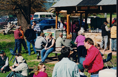
Photograph, 27th August 2004
Taken on the 27th August 2004 the photographs shows attendees of the Direct Seeding Expo that took place at Wooragee Hall socialising and eating during a lunch break. Direct seeding involves the seeds being sowed directly into the soil to achieve germination and establishment. Direct seeding is said to mimic natural processes and can result in trees and shrubs growing healthier root systems. Direct seeding is best for larger areas and can be done at a lower cost. As the Wooragee community values nature, this expo brought together members from the community in order the educate them on direct seeding which would then benefit the community. This photograph is significant at the Wooragee community values nature and believes in replacing what has been lost. Thus, the photograph demonstrates the communities commitment to ensuring the preservation of nature through education of seeding practices.Coloured rectangular photograph printed on gloss photographic paper Reverse: WAN NA E0NA2N2. NNN 0 3585 (No.22) 347wooragee, wooragee landcare, direct seeding expo, 2004 -
 Orbost & District Historical Society
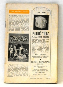
maagazine, Wild Life, July 1951
This magazine promotes the protection of wildlife and the need for proper management of national parks. Its editor Crosbie Morrison lobbied for a National Parks Authority which was finally set up under Morrison's directorship in 1957. During the 1940's and 1950's Crosbie Morrison (1900 - 1958) became Australia's best known naturalist. As a journalist with commercial radio and the Australian Broadcasting Commission, he made regular national nature study broadcasts to schools and other radio listeners for 20 years. He was the editor of Wild Life, a magazine which fostered interest in Australia's natural history and conservation, from 1938-54. (ref. CHAH web-site)This magazine reflects the work and legacy of Crosbie Morrison who campaigned for Victoria's national park system.A 100 pp magazine, covers missing, with b/ w photographs and articles on wildlife. It was intended for campers and those interested in nature. This is Volume 14 No 1.stamp of High School Orbostmagazine-wildlife morrison-crosbie natural-science -
 Orbost & District Historical Society
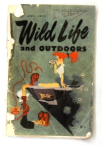
magazine, Wild Life, April 1953
This magazine promotes the protection of wildlife and the need for proper management of national parks. Its editor Crosbie Morrison lobbied for a National Parks Authority which was finally set up under Morrison's directorship in 1957. During the 1940's and 1950's Crosbie Morrison (1900 - 1958) became Australia's best known naturalist. As a journalist with commercial radio and the Australian Broadcasting Commission, he made regular national nature study broadcasts to schools and other radio listeners for 20 years. He was the editor of Wild Life, a magazine which fostered interest in Australia's natural history and conservation, from 1938-54. (ref. CHAH web-site) This magazine reflects the work and legacy of Crosbie Morrison who campaigned for Victoria's national park system.A 398 pp soft covered magazine with green covers. The title "WILD LIFE and OUTDOORS" is in black print.Below this is a coloured drawing of two women camping on the edge of a cliff. One is hanging on to the edge looking at a bird's nest. The magazine contains articles and photographs in black / white print.on front cover - "M. Gilbert' in red penmagazine-wild-life morrison-crosbie natural-history natural-science -
 Ringwood and District Historical Society
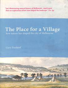
Book, Dr Gary Presland, The Place for a Village - Gary Presland, 2012
Dr Gary Presland studied history at LaTrobe University, Melbourne and archaeology at the University of London. His major research interests have been in Aboriginal and natural history of the Melbourne area. He researched The Place for a Village as a PdD, in the Department of History and Philosophy of Science at The University of Melbourne. His previous books include Aboriginal Melbourne and For God's sake send the trackers. Gary Presland is a Fellow of the Royal Historical Society of Victoria, an Honorary Fellow at The University of Melbourne and an Honorary Associate of Museum Victoria, where he was the 2001 Thomas Ramsay Science and Humanities Fellow. He is a current Editor of The Victorian Naturalist, published by the Field Naturalists Club of Victoria, since 1884.The Place for a Village won The Victorian Community History Awards 2009 for best publication.How nature has shaped the city of MelbourneHandwritten notation first page - With best wishes, Gary Presland 22 February 2020. -
 Eltham District Historical Society Inc
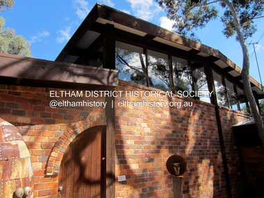
Photograph - Digital Photograph, Jim Connor, 21 Brougham Street, Eltham, 18 March 2012
This building at 21 Brougham Street, Eltham, known previously as The Light Factory, now Second Home restaurant, was designed by Alistair Knox and is one of the few commercial buildings he designed. It was a combined residential (rear) and factory (front) development. The Light Factory Gallery; OnlyMelbourne "The Light Factory Gallery was built in 1973 and is a classic example of his design. Exposed soaring six metre Oregon beams, handmade bricks, clerestory windows flood the building with natural daylight giving treetop views of the eucalypts that he designed the building around." The Light Factory Gallery. (2024, March 31). Retrieved from https://www.onlymelbourne.com.au/the-light-factory-galleryjim connor collection, brougham steet, eltham, alistair knox design, industries, restaurants, second home, the light factory gallery -
 Eltham District Historical Society Inc
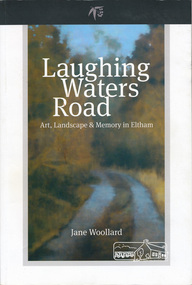
Book, Shire of Nillumbik, Laughing Waters Road: art, landscape & memory by Jane Woollard, 2016
"Laughing Waters has been a source of inspiration for many artists and designers, and was a natural extension of the dynamic art and lifestyle movement that began in the 1930s at Montsalvat. It was also an important site in the development of the Melbourne art scene in the 1960s and '70s, especially the earth building movement known as the Eltham Style. Since 2001 more than eighty artists have been in residence at Laughing Waters in Birrarung House and Riverbend. Their experiences and art making are woven together with Wurundjeri, European and family histories to create an evocative account of a special place in a bushy outer suburb of Melbourne." -- back cover. Eltham District Historical Society is acknowledged in the Acknowledgments section of this book.264 pages : illustrations, maps, portraits ISBN 9780994486707laughing waters, eltham, yarra river, artists, killeavey, mud bricks -
 Federation University Art Collection
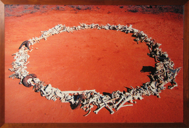
Artwork, other - Print - large format, Michael Shiell, 'Bone Circle - Documentation' by Michael Shiell, 2001
Nanya Station is a magnificent 40,000 hectare property in far western New South Wales. Its unique system of natural salt lakes, old growth Mallee, and variety of intact ecosystems, makes Nanya a significant refuge for biological diversity. Federation University Australia has been the proud custodian of Nanya since 2004, and values Nanya as an important resource in our research, conservation and education programs. Staff and students are committed to creating a research community to preserve and enrich the biodiversity of this important legacy of the University and the nation. This item is part of the Federation University Art Collection. The Art Collection features over 1000 works and was listed as a 'Ballarat Treasure' in 2007.A photographic documentation of sheep, feral goat and kangaroo bones found and photographed at 'Nanya Station'. art, artwork, michael shiell, shiell, nanya, bones, available -
 Warrnambool and District Historical Society Inc.
Booklet, New Bennettitalean Leaves from the Mesozoic of Eastern Australia, 1963
This booklet contains an article on the plant fossil deposits in Eastern Victoria. It has been written by Dr John Douglas in 1963. He published extensively on a range of geological and natural history themes. His major works included co-editing the Geological Society of Victoria’s Geology of Victoria and his PH.D. thesis for the University of Melbourne contained in two Geological Survey Memoirs on the Mesozoic floras of Victoria. He was also responsible for the Geology and Sport and Recreation chapters in the State Government’s Atlas of Victoria and wrote the booklet, What Fossil Plant is That? He was a Supervising Geologist with the Department of Minerals and Energy in Victoria for many years and lectured extensively at Botany and Geology conferences in Australia and overseas. This book is of some interest as it was written by a former resident of Warrnambool, Dr John Douglas (1997 to his death in 2007). He was an active member of the Warrnambool Field Naturalists’ Group and edited for this group the book, The Nature of Warrnambool. This is a small booklet of 16 pages reprinted from the Proceedings of the Royal Society of Victoria, Vol. 77, Part 1. It has a grey cover with the logo of the Royal Society of Victoria on the front cover. It has printed material on plant fossil deposits in eastern Victoria and several sketches and black and white plates of plant fossil photographs and cross-sections. The pages were stapled but the staples have been removed. There is some rust where the staples were removed. Front cover: ‘Royal Society of Victoria, New Bennettitalean Leaves from the Mesozoic of Eastern Australia by J. G. Douglas, reprinted from Proc. Roy. Soc. Victoria, Vol 77, Part 1, Issued separately, 13 December, 1963.’ micro- paleontology in eastern victoria, dr john douglas, warrnambool -
 Bendigo Historical Society Inc.
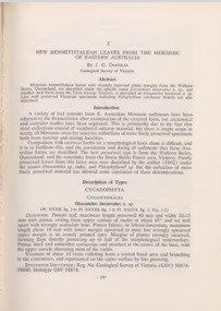
Newspaper - JENNY FOLEY COLLECTION: WORLD CHAMPION
John (Jack ) Donaldson was born in Raywood in 1886 but he was raised in Inglewood. A natural runner he held 6 world records in sprint events from 100 yards to 400 yards. He came second in his first appearance at the Stawell Gift in 1906. He was nicknamed "The Blue Streak" and raced all over the world in official professional races, exhibitions and challenge events. He moved to New York in 1919 where he married Ethel Auer in 1925. He ran a gymnasium in NY but committed suicide in 1933. He is remembered each year with the running of the "Jack Donaldson 200m. handicap " race at the Stawell Gift meeting.Bendigo Advertiser ''the way we were'' from Friday, January 2, 2004. World champion: Inglewood's John Donaldson, better known as Jack, was born in 1886. Although he lacked professional training, Jack skyrocketed to fame as a sprinter. Starting at the Stawell gift, his stride of eight feet, four inches, soon earned him world records for the 150 and 300 yard races; records which stood for nearly 100 years. He died in 1933 at the age of 49. The clip is in a folder.newspaper, bendigo advertiser, the way we were -
 City of Moorabbin Historical Society (Operating the Box Cottage Museum)
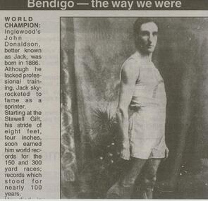
Photographs, x3 Colour,, Highett Gasworks c1974, 1974
3 of 5 photographs of the Highett Gasworks c 1974 The Brighton Gas Company was established 1877 by local residents including Thomas Bent. Initially all went well for residents as gas light replaced kerosene lamps and street lights were installed. However disruption to supply, poor quality and failure to reach all house lead to dissatisfaction. Thomas Bent therefore began the Central Brighton and Moorabbin Gas Company 1885 and a price war ensued. This was unsustainable and the two companies amalgamated in 1877 supplying gas from the New Street Works site. 1930 this Company expanded to Highett where it had purchased 45 acres adjacent to the train line. 1927 a gas holder was built connected to the Brighton works 1936 construction began on a complete gas-making unit and the Highett Gasworks, Nepean Highway, began supply 1939. 1950 an extension program was completed. However by 1965 , with the discovery of Natural Gas offshore in Bass Strait, changes to Gas distribution were apparent. At first some of the facilities at Highett were used to distribute the gas piped from Sale, Gippsland. However after conversion of 450,000 homes to Natural Gas the Highett site was redundant. The gasometers were removed 1978. Moorabbin Council obtained part of the land for public recreation purposes. ( Dr. G Whitehead KCC Historian ) c2012 the Moorabbin Justice Centre / Magistrates Court of Victoria was built and further development of the area for apartments proceeds. The establishment of the Brighton Gas Company 1877 and the Highett Gasworks 1885 brought bright lighting to houses, businesses and streets in Moorabbin Shire and cooking ovens and heating improved the living conditions of residents. 3 x Colour photographs of the Highett Gasworks c1970bass strait gas, highett gasworks, brighton gasworks 1877, central brighton and moorabbin gas company 1885, whitehead dr. graham, magistrates court of victoria, horse drawn carts, toll gates brighton, motor cars 1900, steam engines, early settlers, bentleigh, parish of moorabbin, city of moorabbin, county of bourke, moorabbin roads board, shire of moorabbin, henry dendy's special survey 1841, were j.b.; bent thomas, o'shannassy john, king richard, charman stephen, highett william, ormond francis, maynard dennis, market gardeners, vineyards, orchards -
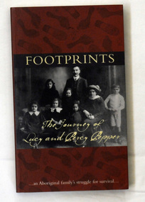 Orbost & District Historical Society
book, Footprints, 2008
Co-author Simon Flagg from the Koorie Records Unit, Public Record Office Victoria, did most of the research for the book. Rita Watkins, a descendent of Percy and Lucy, provided photographs and family stories for the book. "As well as brief chapter introductions, the book contains transcripts of the letters to, from and about the Pepper Family. Among various aspects of the family's life, the letters show Lucy Pepper's long battle with tuberculosis and her request to live with other family members on a mission. But she was denied this natural wish because 'half-caste' Aboriginal people were excluded from the missions." -co-author Simon Flagg from the Koorie Records Unit, Public Record Office Victoria,This book, with its transcripts of original letters, is an invaluable historical resource for university and school students on Aboriginal history in Victoria and what happened on Aboriginal reserves. A book titled "Footprints", which portrays the struggles of Lucy and Percy Pepper in the first half of the twentieth century. It was published jointly by the National Archives of Australia and Public Record Office Victoria, both of which hold original records of the family's correspondence with bureaucracy over the years. The book was authored by Simon Flagg and Dr Sebastian Gurciullo. The cover has a dark brown background with black footprints printed over it. They are both bare foot and shoe prints. It has a b /w photograph of a family posed for the camera. Across the top is the title FOOTPRINTS printed in pale yellow. At the bottom of the photo in pale yellow script is "the journey of Lucy and Percy Pepper". At the foot of the front cover is " An Aboriginal Family's struggle for survival". pepper-family aboriginal-history -
 Kiewa Valley Historical Society
Postcard Circa 1950, Snow Plough, Bogong High Plain,5,500 Feet Kiewa Hydro-Electric Project, Circa 1950
This postcard was produced in the 1950's for the tourist trade in the Kiewa Valley and Alpine region. It encompasses the period when the State of Victoria was pressured by the ever increasing demand by industry and its population for electricity supplies. Hydro electricity was seen as an untapped natural resource to quench this demand. The Victorian Alps and the rivers flowing into its valleys was ideal for the construction of the Kiewa Hydro Electricity Scheme. The late 1940's saw the development of this scheme and the changing of sections of alpine landscape is covered by this and other postcards/pictures (tourists, construction workers, and established rural populations). This period in time was before the established wildlife and forest/nature groups became political activist who changed legislative acts to protect the environment. This rural region (Kiewa Valley/alpine plains) was at most only significant to a smaller group of winter sports, summer hikers/horse riders and rural farmers/graziers. The numbers of tourists and the increase in the local resident population was boosted by the construction of the Hydro Electricity Scheme. This influx to the regional population resulted in a corresponding diversity in services and brought about an environment that responded to a growing level of tourists and thereby permitting this industry to grow more rapidly than it would have naturally. This postcard details an attraction to the "cleaner" method of providing electricity. This postcard was purchased in 1950 by a surveyor at Landford's Gap. This item is a black and white photograph(professional) of a panoramic view of a snow plough clearing the unsealed road in 1950.This postcard is on quality paper and the reproduction of the picture is of a high standard.For other "tourist" postcards see 0480 (A) -(F) for other photos of similar postcards. kiewa valley tourism, victorian alps, alternate energy supplies, alpine population growth, secv, snow plough -
 Kiewa Valley Historical Society
Postcard Circa 1950, Road to Bogong High Plains Kiewa Hydro Electric Project, Circa 1950's
This postcard was produced in the 1950's for the tourist trade in the Kiewa Valley and Alpine region. It encompasses the period when the State of Victoria was pressured by the ever increasing demand by industry and its population for electricity supplies. Hydro electricity was seen as an untapped natural resource to quench this demand. The Victorian Alps and the rivers flowing into its valleys was ideal for the construction of the Kiewa Hydro Electricity Scheme. The late 1940's saw the development of this scheme and the changing of sections of alpine landscape is covered by this and other postcards/pictures (tourists, construction workers, and established rural populations). This period in time was before the established wildlife and forest/nature groups became political activist who changed legislative acts to protect the environment.This rural region (Kiewa Valley/alpine plains) was at most only significant to a smaller group of winter sports, summer hikers/horse riders and rural farmers/graziers. The numbers of tourists and the increase in the local resident population was boosted by the construction of the Hydro Electricity Scheme. This influx to the regional population resulted in a corresponding diversity in services and brought about an environment that responded to a growing level of tourists and thereby permitting this industry to grow more rapidly than it would have naturally. This postcard details an attraction to the "cleaner" method of providing electricity. This postcard was purchased in 1950 by a surveyor at Landford's Gap.This black and white photograph on a Valentine's postcard is from a V2 Argus photograph.. It is on a 200g/m paper density photo side gloss. See 0480 (A) - (G) for other photos of similar postcards.In white lettering " ROAD TO BOGONG HIGH PLAINS KIEWA HYDRO-ELECTRIC PROJECT", V3secv, road making, victorian alps -
 Kiewa Valley Historical Society
Postcard - Rocky Valley - Circa 1950, 1950
This postcard was produced in the 1950's for the tourist trade in the Kiewa Valley and Alpine region. It encompasses the period when the State of Victoria was pressured by the ever increasing demand by industry and its population for electricity supplies. Hydro electricity was seen as an untapped natural resource to quench this demand. The Victorian Alps and the rivers flowing into its valleys was ideal for the construction of the Kiewa Hydro Electricity Scheme. The late 1940's saw the development of this scheme and the changing of sections of alpine landscape is covered by this and other postcards/pictures (tourists, construction workers, and established rural populations). This period in time was before the established wildlife and forest/nature groups became political activist who changed legislative acts to protect the environment.This rural region (Kiewa Valley/alpine plains) was at most only significant to a smaller group of winter sports, summer hikers/horse riders and rural farmers/graziers. The numbers of tourists and the increase in the local resident population was boosted by the construction of the Hydro Electricity Scheme. This influx to the regional population resulted in a corresponding diversity in services and brought about an environment that responded to a growing level of tourists and thereby permitting this industry to grow more rapidly than it would have naturally. This postcard details an attraction to the "cleaner" method of providing electricity. This postcard was purchased in 1950 by a surveyor at Landford's Gap.This black and white photograph is from a Valentine's V2 Argus postcard. It is on a 200g/m paper density one side gloss. See also KVHS 0480 (A) to (L) for similar postcards. "ROCKY VALLEY FROM BOGONG HIGH PLAINS KIEWA HYDRO-ELECTRIC PROJECT" "V1"kiewa valley tourism, victorian alps, alternate energy supplies, alpine population growth, rocky valley, secv -
 Kiewa Valley Historical Society
Postcard - Junction Dam - Circa 1950, Circa 1950's
This postcard was produced in the 1950's for the tourist trade in the Kiewa Valley and Alpine region. It encompasses the period when the State of Victoria was pressured by the ever increasing demand by industry and its population for electricity supplies. Hydro electricity was seen as an untapped natural resource to quench this demand. The Victorian Alps and the rivers flowing into its valleys was ideal for the construction of the Kiewa Hydro Electricity Scheme. The late 1940's saw the development of this scheme and the changing of sections of alpine landscape is covered by this and other postcards/pictures (tourists, construction workers, and established rural populations). This period in time was before the established wildlife and forest/nature groups became political activist who changed legislative acts to protect the environment.This rural region (Kiewa Valley/alpine plains) was at most only significant to a smaller group of winter sports, summer hikers/horse riders and rural farmers/graziers. The numbers of tourists and the increase in the local resident population was boosted by the construction of the Hydro Electricity Scheme. This influx to the regional population resulted in a corresponding diversity in services and brought about an environment that responded to a growing level of tourists and thereby permitting this industry to grow more rapidly than it would have naturally. This postcard details an attraction to the "cleaner" method of providing electricity. This postcard was purchased in 1950 by a surveyor at Landford's Gap.This black and white photograph is a Valentine's postcard, from a V2 Argus photograph. It is on a 200g/m paper density with only the photo side gloss.Front "JUNCTION DAM & SPILLWAY, BOGONG KIEWA HYDRO-ELECTRIC PROJECT" on the flip side "VALENTINE'S POST CARD " "A GENUINE PHOTOGRAPH"kiewa valley tourism, victorian alps, alternate energy supplies, alpine population growth, junction dam, secv -
 Kiewa Valley Historical Society
Postcard - Junction Dam - Circa 1950, Circa 1950
This postcard was produced in the 1950's for the tourist trade in the Kiewa Valley and Alpine region. It encompasses the period when the State of Victoria was pressured by the ever increasing demand by industry and its population for electricity supplies. Hydro electricity was seen as an untapped natural resource to quench this demand. The Victorian Alps and the rivers flowing into its valleys was ideal for the construction of the Kiewa Hydro Electricity Scheme. The late 1940's saw the development of this scheme and the changing of sections of alpine landscape is covered by this and other postcards/pictures (tourists, construction workers, and established rural populations). This period in time was before the established wildlife and forest/nature groups became political activist who changed legislative acts to protect the environment.This rural region (Kiewa Valley/alpine plains) was at most only significant to a smaller group of winter sports, summer hikers/horse riders and rural farmers/graziers. The numbers of tourists and the increase in the local resident population was boosted by the construction of the Hydro Electricity Scheme. This influx to the regional population resulted in a corresponding diversity in services and brought about an environment that responded to a growing level of tourists and thereby permitting this industry to grow more rapidly than it would have naturally. This postcard details an attraction to the "cleaner" method of providing electricity. This postcard was purchased in 1950 by a surveyor at Landford's Gap.This black and white photograph on a Valentine's postcard is from a V2 Argus photograph. It is on a 200g/m paper density one side gloss only/. See 0480 (A) -(L) for other photos of similar postcards."JUNCTION DAM & SPILLWAY, LAKE GUY, BOGONG, KIEWA HYDRO-ELECTRIC PROJECT" "V5" on the flip side" VALENTINE'S POST CARD " "A GENUINE PHOTOGRAPH"kiewa valley tourism, victorian alps, alternate energy supplies, alpine population growth, junction dam, secv -
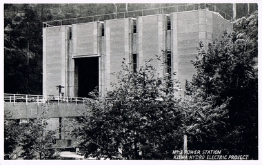 Kiewa Valley Historical Society
Postcard Circa 1950, No.3 Power Station Kiewa Hydro-electric Project "V.8", Circa 1950
This postcard was produced in the 1950's for the tourist trade in the Kiewa Valley and Alpine region. It encompasses the period when the State of Victoria was pressured by the ever increasing demand by industry and its population for electricity supplies. Hydro electricity was seen as an untapped natural resource to quench this demand. The Victorian Alps and the rivers flowing into its valleys was ideal for the construction of the Kiewa Hydro Electricity Scheme. The late 1940's saw the development of this scheme and the changing of sections of alpine landscape is covered by this and other postcards/pictures (tourists, construction workers, and established rural populations). This period in time was before the established wildlife and forest/nature groups became political activist who changed legislative acts to protect the environment.This rural region (Kiewa Valley/alpine plains) was at most only significant to a smaller group of winter sports, summer hikers/horse riders and rural farmers/graziers. The numbers of tourists and the increase in the local resident population was boosted by the construction of the Hydro Electricity Scheme. This influx to the regional population resulted in a corresponding diversity in services and brought about an environment that responded to a growing level of tourists and thereby permitting this industry to grow more rapidly than it would have naturally. This postcard details an attraction to the "cleaner" method of providing electricity. This postcard was purchased in 1950 by a surveyor at Landford's Gap.This black and white photograph from a Valentine's postcard is from a V2 Argus photograph postcard. It is on a 200g/m paper density photo side gloss. See 0480 (A) - (K) for other photos of similar postcards."No.3 POWER STATION KIEWA HYDRO ELECTRIC PROJECT" "V8"kiewa valley tourism, victorian alps, alternate energy supplies, alpine population growth, secv -
 Kiewa Valley Historical Society
Postcard Circa 1950, Lake Guy Dam and Bogong Village, Circa 1950
This postcard was produced in the 1950's for the tourist trade in the Kiewa Valley and Alpine region. It encompasses the period when the State of Victoria was pressured by the ever increasing demand by industry and its population for electricity supplies. Hydro electricity was seen as an untapped natural resource to quench this demand. The Victorian Alps and the rivers flowing into its valleys was ideal for the construction of the Kiewa Hydro Electricity Scheme. The late 1940's saw the development of this scheme and the changing of sections of alpine landscape is covered by this and other postcards/pictures (tourists, construction workers, and established rural populations). This period in time was before the established wildlife and forest/nature groups became political activist who changed legislative acts to protect the environment.This rural region (Kiewa Valley/alpine plains) was at most only significant to a smaller group of winter sports, summer hikers/horse riders and rural farmers/graziers. The numbers of tourists and the increase in the local resident population was boosted by the construction of the Hydro Electricity Scheme. This influx to the regional population resulted in a corresponding diversity in services and brought about an environment that responded to a growing level of tourists and thereby permitting this industry to grow more rapidly than it would have naturally. This postcard details an attraction to the "cleaner" method of providing electricity. This postcard was purchased in 1950 by a surveyor at Landford's Gap.This black and white photograph from a Valentine's postcard is from a V2 Argus photograph postcard. It is on a 200g/m paper density photo side gloss. See 0480 (B) - (F) for other photos of similar postcards.In white lettering " LAKE GUY & BOGONG VILLAGE KIEWA HYDRO-ELECTRIC PROJECT"kiewa valley tourism, victorian alps, alternate energy supplies, alpine population growth -
 Kiewa Valley Historical Society
Postcard Circa 1950, Snowfall at Bogong Village Kiewa Hydro-Electric Project, 1950s
This postcard was produced in the 1950's for the tourist trade in the Kiewa Valley and Alpine region. It encompasses the period when the State of Victoria was pressured by the ever increasing demand by industry and its population for electricity supplies. Hydro electricity was seen as an untapped natural resource to quench this demand. The Victorian Alps and the rivers flowing into its valleys was ideal for the construction of the Kiewa Hydro Electricity Scheme. The late 1940's saw the development of this scheme and the changing of sections of alpine landscape is covered by this and other postcards/pictures (tourists, construction workers, and established rural populations). This period in time was before the established wildlife and forest/nature groups became political activist who changed legislative acts to protect the environment.This rural region (Kiewa Valley/alpine plains) was at most only significant to a smaller group of winter sports, summer hikers/horse riders and rural farmers/graziers. The numbers of tourists and the increase in the local resident population was boosted by the construction of the Hydro Electricity Scheme. This influx to the regional population resulted in a corresponding diversity in services and brought about an environment that responded to a growing level of tourists and thereby permitting this industry to grow more rapidly than it would have naturally. This postcard details an attraction to the "cleaner" method of providing electricity. This postcard was purchased in 1950 by a surveyor at Landford's Gap.This scanned black and white photograph of a postcard, shows vehicles covered in thick snow at Bogong Village in 1950. See 0480(A), (C) - (F) for other similar photos of postcards available at this period."SNOWFALL AT BOGONG VILLAGE KIEWA HYDRO-ELECTRICITY PROJECT"kiewa valley tourism, victorian alps, alternate energy supplies, alpine population growth, bogong village, secv -
 Kiewa Valley Historical Society
Postcard Circa 1950, Scene in Bogong Village Kiewa Hydro-Electric Project, 1950s
This postcard was produced in the 1950's for the tourist trade in the Kiewa Valley and Alpine region. It encompasses the period when the State of Victoria was pressured by the ever increasing demand by industry and its population for electricity supplies. Hydro electricity was seen as an untapped natural resource to quench this demand. The Victorian Alps and the rivers flowing into its valleys was ideal for the construction of the Kiewa Hydro Electricity Scheme. The late 1940's saw the development of this scheme and the changing of sections of alpine landscape is covered by this and other postcards/pictures (tourists, construction workers, and established rural populations). This period in time was before the established wildlife and forest/nature groups became political activist who changed legislative acts to protect the environment. This rural region (Kiewa Valley/alpine plains) was at most only significant to a smaller group of winter sports, summer hikers/horse riders and rural farmers/graziers. The numbers of tourists and the increase in the local resident population was boosted by the construction of the Hydro Electricity Scheme. This influx to the regional population resulted in a corresponding diversity in services and brought about an environment that responded to a growing level of tourists and thereby permitting this industry to grow more rapidly than it would have naturally. This postcard details an attraction to the "cleaner" method of providing electricity. This postcard was purchased in 1950 by a surveyor at Landford's Gap. The couple shown in this photograph would have been employed by the S.E.C. under the Kiewa Hydro-Electricity Scheme.This item is a scanned black and white photograph of a couple walking along a gravel street in Bogong Village in 1950. See 0480 (A) ,(B), (D) - (F) for other photos of similar postcards" SCENE IN BOGONG VILLAGE KIEWA HYDRO-ELECTRIC PROJECT"kiewa valley tourism, victorian alps, alternate energy supplies, alpine population growth, bogong, secv -
 Kiewa Valley Historical Society
Postcard Circa 1950, Howman Gap Hostel under snow Kiewa Hydro-Electric Project, Circa 1950
This postcard was produced in the 1950's for the tourist trade in the Kiewa Valley and Alpine region. It encompasses the period when the State of Victoria was pressured by the ever increasing demand by industry and its population for electricity supplies. Hydro electricity was seen as an untapped natural resource to quench this demand. The Victorian Alps and the rivers flowing into its valleys was ideal for the construction of the Kiewa Hydro Electricity Scheme. The late 1940's saw the development of this scheme and the changing of sections of alpine landscape is covered by this and other postcards/pictures (tourists, construction workers, and established rural populations). This period in time was before the established wildlife and forest/nature groups became political activist who changed legislative acts to protect the environment.This rural region (Kiewa Valley/alpine plains) was at most only significant to a smaller group of winter sports, summer hikers/horse riders and rural farmers/graziers. The numbers of tourists and the increase in the local resident population was boosted by the construction of the Hydro Electricity Scheme. This influx to the regional population resulted in a corresponding diversity in services and brought about an environment that responded to a growing level of tourists and thereby permitting this industry to grow more rapidly than it would have naturally. This postcard details an attraction to the "cleaner" method of providing electricity. This postcard was purchased in 1950 by a surveyor at Landford's Gap.This item is a scanned black and white photograph of a panoramic view of Howman Gap Hostel under snow in 1950 (a closed village, entry by pass only). This accommodation was for construction workers only. See 0480 (A) -(E) for other photos of similar postcards.On the photo, " Howman Gap Hostel under snow Kiewa Hydro-Electric Project" . On postcard address and personal information side "V.2 Valentine's Post Card "kiewa valley tourism, victorian alps, alternate energy supplies, alpine population growth, bogong, secv, howman's gap hostel -
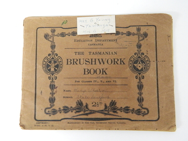 Kiewa Valley Historical Society
Book - Sketch Book, Circa 1918
This childhood sketchbook of the 1918 era details the emphasis placed upon a skill of brushwork that portrayed part of the students natural environment both in Tasmanian schools and Victorian schools, especially rural schools. The close bondage between students and their environment was a reflection on the early "hands on" approach in child education. Abstract art or teaching aids which could not be identified with physical properties available to students at this period in time were of lesser value. The ability of the student to identify the artistic value of local nature eg. local plants and flowers was especial important to rural based school children who had limited excursion opportunities available to visit town/city based botanical gardens and museums. This brushwork book is very significant to the Kiewa Valley as it demonstrates that childhood relocations from one State to another were not detrimental to the students overall scholastic development. The rural environment in Tasmania was not that far removed from the rural environment of the Kiewa Valley. The skills taught in both regions were still the same and the socio-economic factors and mores were also similar. This item demonstrates the relocation of one family from Tasmania to the Kiewa Valley. The expansion in population into the Kiewa valley was quite erratic and significant population growth only came after the increase in population brought into the area by the SEC Vic Hydro Scheme introduced to quench the demand for Victoria's electricity.This book has a brown cover with black print and designs on a 150 gsm cardboard. Each page is of the same thickness as the cover but is of paper.On the outside cover and contained within a thick boarder. "EDUCATION DEPARTMENT" and below this in smaller print "TASMANIA" below this "THE TASMANIAN BRUSHWORK BOOK". Below this "FOR CLASSES IV., V., AND VI" Below this "NAME" SCHOOL" At the bottom 2 1/2d1918's educational sketchbook, 1918 children's sketchbook -
 Nillumbik Shire Council
Print (etching): Dean BOWEN, The Offering, 1997
Dean Bowen is renowned for his charming, child-like aesthetic and unique thematic interplay between the urban and rural as well as humans and animals. Bowen has developed a distinctive and humorous symbolic language that filters through each work. His highly charismatic and whimsical renderings of animals, human characters and Australian environments celebrate the vicissitudes of life, evincing the simple pleasures of human habitation within the artificial and the natural world. The work and thoughts of Jean Dubuffet, particularly those which focus on the philosophy of 'Art Brut', give support to Dean's belief that untrained artists are more honest, that artists interested in emulating the art of children are trying to regain the pure expression they lost with childhood. 'The Offering' was a finalist in the Nillumbik Art Awards in 1997. The work refers to the act of giving back, rather than taking which Bowen sees as more prevalent in our Western society. While the image is childlike, the expression of the boy is a mixture of sadness and happiness, knowing and naivety, youth and age. The smile has a Mona Lisa quality and the earthy and sensuous colours suggest landscape. When realising the images he relies on memory rather than observation so that the struggle with drawing and representation sometimes doesn't work. The style of the drawing and the flat space relates to the graphic style of cartoons and caricature. The intuitive and the imaginative are essential elements in his work. lower right 'Dean Bowen '97' -
 Kew Historical Society Inc
Photograph, Floods in North Kew, 1971
Living with natural processes was frequently a challenge to early European settlers and later residents of what was in the 1850s administered by the Borondara Road Board. This was compounded by the area being bounded on three sides by rivers (Yarra River, Koonung Creek and Gardiner's Creek). In 1849, the historian James Bonwick recorded that "our district [Kew] suffered considerably. Mr Wade speaks of 80 acres, out of 100 acres of his cultivated paddock, covered by water." Newspapers continued to describe major flooding in Kew in 1863, 1869, 1878, 1880, 1889, 1891, 1916 and 1934. While the construction of the Upper Yarra dam in 1957 reduced the levels of flowing downstream, local and riverine floods continue.The Kew Historical Society's pictures and map collections testify to the impact of flooding in the district. They have historical importance in documenting the extent of flooding in the district and its affects on homes, services and recreation. Numerous photographs record flooding throughout the Twentieth Century.Floods in North Kew, 1971. Looking northeast towards Kilby Road from River Avenue. Annotation on reverse: map and date "8 Nov. 71 10.30am".floods (kew), yarra river, kew flood, kilby road flood -
 Kew Historical Society Inc
Photograph, Floods in North Kew, 1934
Living with natural processes was frequently a challenge to early European settlers and later residents of what was in the 1850s administered by the Borondara Road Board. This was compounded by the area being bounded on three sides by rivers (Yarra River, Koonung Creek and Gardiner's Creek). In 1849, the historian James Bonwick recorded that "our district [Kew] suffered considerably. Mr Wade speaks of 80 acres, out of 100 acres of his cultivated paddock, covered by water." Newspapers continued to describe major flooding in Kew in 1863, 1869, 1878, 1880, 1889, 1891, 1916 and 1934. While the construction of the Upper Yarra dam in 1957 reduced the levels of flowing downstream, local and riverine floods continue.The Kew Historical Society's pictures and map collections testify to the impact of flooding in the district. They have historical importance in documenting the extent of flooding in the district and its affects on homes, services and recreation. Numerous photographs record flooding throughout the Twentieth Century.Floods in North Kew, 1934. Vicinity of Willsmere Park.floods (kew) -
![Flooding at Chipperfield's Boathouse [East Kew], 1934](/media/collectors/550653872162f11fb04854aa/items/58cbaad5d0cec425b474bfb1/item-media/58cf6fbdd0cf9f331490feb0/item-fit-380x285.jpg) Kew Historical Society Inc
Kew Historical Society IncPhotograph, Flooding at Chipperfield's Boathouse, 1934
Living with natural processes was frequently a challenge to early European settlers and later residents of what was in the 1850s administered by the Borondara Road Board. This was compounded by the area being bounded on three sides by rivers (Yarra River, Koonung Creek and Gardiner's Creek). In 1849, the historian James Bonwick recorded that "our district [Kew] suffered considerably. Mr Wade speaks of 80 acres, out of 100 acres of his cultivated paddock, covered by water." Newspapers continued to describe major flooding in Kew in 1863, 1869, 1878, 1880, 1889, 1891, 1916 and 1934. While the construction of the Upper Yarra dam in 1957 reduced the levels of flowing downstream, local and riverine floods continue.The Kew Historical Society's pictures and map collections testify to the impact of flooding in the district. They have historical importance in documenting the extent of flooding in the district and its affects on homes, services and recreation. Numerous photographs record flooding throughout the Twentieth Century.Floods in North Kew, 1934. Chipperfield's Boathouse and the adding Moorings was located beside the Yarra River near the corner of Willsmere and Kilby Roads. The flood reached the roof of the Moorings, which can be seen in the photo.floods (kew), floods (kew) 1934, yarra river -
 Kew Historical Society Inc
Photograph, Floods in North Kew, 1934
Living with natural processes was frequently a challenge to early European settlers and later residents of what was in the 1850s administered by the Borondara Road Board. This was compounded by the area being bounded on three sides by rivers (Yarra River, Koonung Creek and Gardiner's Creek). In 1849, the historian James Bonwick recorded that "our district [Kew] suffered considerably. Mr Wade speaks of 80 acres, out of 100 acres of his cultivated paddock, covered by water." Newspapers continued to describe major flooding in Kew in 1863, 1869, 1878, 1880, 1889, 1891, 1916 and 1934. While the construction of the Upper Yarra dam in 1957 reduced the levels of flowing downstream, local and riverine floods continue.The Kew Historical Society's pictures and map collections testify to the impact of flooding in the district. They have historical importance in documenting the extent of flooding in the district and its affects on homes, services and recreation. Numerous photographs record flooding throughout the Twentieth Century.Floods in North Kew, 1934. Unidentified location on the Yarra Flood Plain at Kew.floods (kew) 1934, yarra river -
 Kew Historical Society Inc
Photograph, Floods in North Kew, 1934
Living with natural processes was frequently a challenge to early European settlers and later residents of what was in the 1850s administered by the Borondara Road Board. This was compounded by the area being bounded on three sides by rivers (Yarra River, Koonung Creek and Gardiner's Creek). In 1849, the historian James Bonwick recorded that "our district [Kew] suffered considerably. Mr Wade speaks of 80 acres, out of 100 acres of his cultivated paddock, covered by water." Newspapers continued to describe major flooding in Kew in 1863, 1869, 1878, 1880, 1889, 1891, 1916 and 1934. While the construction of the Upper Yarra dam in 1957 reduced the levels of flowing downstream, local and riverine floods continue.The Kew Historical Society's pictures and map collections testify to the impact of flooding in the district. They have historical importance in documenting the extent of flooding in the district and its affects on homes, services and recreation. Numerous photographs record flooding throughout the Twentieth Century.Floods in North Kew, 1934. Chipperfield's Boat House under flood.floods (kew) 1934, yarra river, chipperfield's boat house