Showing 11784 items
matching geo-map
-
 Bendigo Historical Society Inc.
Document - LYDIA CHANCELLOR COLLECTION: BENDIGO POTTERY NOTES FROM GEO. MACKAYS 'HISTORY OF BENDIGO' SEPT 1891, 1891
LYDIA CHANCELLOR COLLECTION: Bendigo Pottery NOTES FROM GEO. MACKAYS 'HISTORY OF BENDIGO' SEPT 1891 Handwritten notesbendigo, history, bendigo pottery -
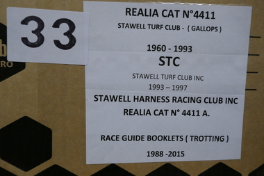 Stawell Historical Society Inc
Memorabilia - Realia, 1960-1996
Stawell Harness Racing Club Inc & Stawell Turf Club Inc race Books. Property of Geo Davies, Melbournestawell -
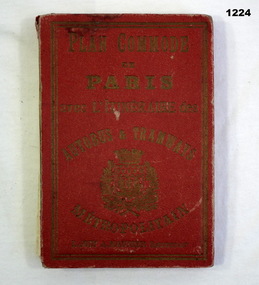 Bendigo Military Museum
Plan - MAP, TOURIST, L Joly, A Maunier, WWI
The map belonged to Jack Grinton No 1043 38th Batt AIF. At Wars end extensive leave was granted, Jack journeyed to Paris, Nice, Monte Carlo taking many photos. Part of the Grinton collection which included hundreds of negatives and developed photos that he took during the War. Refer Cat No 1280 for service details. Refer 1317P, 1320P.Map of Paris. Red cardboard or paper hardcover, new edition guide of metropolitan Paris (ministries, tramways, monuments), Index in front, folded paper map attached to back cover. "Plan commode de Paris avec l'itineraire des autobus & tramways metropolitan"documents-maps, french -
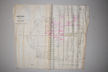 Warrnambool and District Historical Society Inc.
Maps (2), 1 Kapong .2 Hawkesdale, 1 1913 .2 1942
These two maps of the Kapong/ Hawkesdale area in Victoria show the original lands that belonged to the pioneer settler, Charles Hamilton MacKnight and the handwritten annotations that show the subsequent owners of these lands. Charles Hamilton Macknight (1819-1873) came to Australia from Scotland in 1841 and in 1842, with partners, James Irvine and William Campbell, established the property of Dunmore in Broadwater (24 kilometres from Hawkesdale). He was a prominent breeder of sheep, cattle and horses. Sections of his lands were acquired by the Baulch family and these maps were acquired from a member of the Baulch family, with Stanley Baulch being the possible annotator of the Kapong map. These maps are of interest as they show the properties that belonged to the pioneer settler, Charles Hamilton MacKnight and the subsequent division of these lands, some of these passing into the hands of the Baulch family. As the Kapong map also shows other original landowners, it will be a useful tool for researchers..1 This is a map of Kapong in the County of Villiers. It is on a rectangular-shaped piece of linen-backed paper with black printing and some handwritten annotations in red ink. It is crumpled at the edges. .2 This is a rectangular-shaped piece of paper showing a map of the Hawkesdale area. The printed material is in grid form in black, green and red. At the left bottom edge it has a mauve stamp. kapong, victoria, hawkesdale, victoria, dunmore estate, victoria, charles hamilton macknight, baulch family, western victoria, history of warrnambool -
 Doncaster RSL Sub Branch
Papers Bomber D4854
Maps 11-02-43 Wilhelmshaven,8-03-43 Nurnburg 27-03-43 Berlin, logs Nurnburg and Berlin. Lancaster Squadron 156 Pathfinder RAF Warboys Huntingdonshire.Sgt. Patrick Brougham(Faddy) Commenced operations Feb 1943 killed on operation to Skoda16-04-1943 aged 18 1/2, buried with his six companions Brimond near Rheims France.Maps three Missions and Engineers log for two missions -
 Shepparton RSL Sub Branch
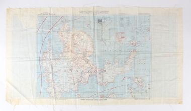
Escape Map Cloth, July 1944
Silk escape map issued to Allied Airmen during World War 11 for the Pacific campaignsA silk escape map including detail of tides and winds was relevant to air force personnel in Pacific regions during WW2. Coloured Cloth Escape Map of Side A : No. C44 North Borneo Side B: No C43 Mindanao Island SCALE: 1:1,000,000; Wind and Current markings; AAF Cloth Cart- Philippine Series Prepared under the direction of the Commanding General, Army Air Forces, by the aeronautical Chart Service, Washington DC July 1944world war ii, second world war, silk escape map, pacific conflict -
 Bacchus Marsh & District Historical Society
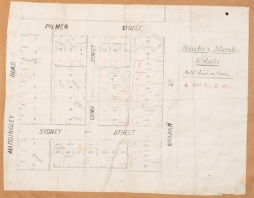
Map, Bacchus Marsh Estate sold 30th June 1888 and sold 28 December 1895
Blocks of land in this area of Bacchus Marsh were sold in lots between 1888 and the late 1890s. This map shows sales made in 1888 and 1895.Single page map showing allotments of land bounded by Pilmer Street, Graham Street, Sydney Street and Maddingley Road (Grant Street) in Bacchus Marsh.The area is dissected by Como Street down the central area. 43 blocks of land are shown with the names of buyers or sellers in 1888 written in black in. Buyers or sellers for December 1895 are written in red ink. Part of a set of maps which are pasted into a bound volume containing 76 maps or plans in total. High resolution digital image stored on BMDHS computer network. bacchus marsh victoria maps, land sales bacchus marsh, pilmer street bacchus marsh, graham street bacchus marsh, sydney street bacchus marsh, como street bacchus marsh, maddingley road bacchus marsh, grant street bacchus marsh -
 Orbost & District Historical Society
map/brochure, Discovering Marlo & The Snowy River Estuary, December 1988
In 1983 the Department of Conservation, Forests and Lands replaced the Department of Crown Lands and Survey, the Department of State Forests and the Ministry for Conservation. This brochure/map was used as tourist information in Orbost.This item is a useful research tool.A folded map/brochure titled "DISCOVERING MARLO & THE SNOWY RIVER ESTUARY". On the front is a photograph of Marlo and the title in yellow print. There is a locality map for access to Corringle beach and the brochure Includes a key to fishing sites and various tourist locations. On the back of the brochure are notes on fishing, wildlife and a boating guide, map brochure snowy-river marlo -
 Warrnambool and District Historical Society Inc.
Map, Soil conservation authority:plan of high water marks at Lady Bay Warrnambool, 1984
This map documents the changing state of Lady Bay from around 1870 until 1976. It depicts the changing high water mark over that period and the main outlet of the Merri River in 1872 and 1976.This map provides a useful and significant insight into the ever changing face of Lady Bay from the 1870’s through to 1980’s. Cream paper map drawn with black ink showing Lady Bay and South Warrnambool section of Warrnambool. In lower RH corner Soil conservation AuthorityPlan of High water marks at Lady Bay Warrnambool. Drawn P.D. 19.1/84. Scale 1:3600. Written on back in black pencil: Lady Bay Historical HWM lady bay map, merri river 1872- 1976, merri river 1872- 1976, history of warrnambool -
 Phillip Island and District Historical Society Inc.
Photograph, Bryant West
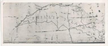
One of a collection of over 400 photographs in an album commenced in 1960 and presented to the Phillip Island & Westernport Historical Society by the Shire of Phillip IslandPhotograph of an early Map of Phillip Island not drawn to scale. Copy from Records Office, London.On back of photo - "If used must bear acknowedgement - reproduced by permission of the Hydrographer of the Navy" "Received 18/3/1955 from London Records Office per Mr mcGrigor-Phillips" Printed on Map "Phillip Island"local history, photography, photographs, maritime documents, maps, exploration, john jenner, bryant west, phillip island map -
 Phillip Island and District Historical Society Inc.
Photograph
One of a collection of over 400 photographs in an album commenced in 1960 and presented to the Phillip Island & Westernport Historical Society by the Shire of Phillip IslandPhotograph of members of Walton and Jenner families on the verandah of wattle and daub house. Built in 1903 by H Jenner Senior. People in the photograph are from Left to Right: W Jenner, Mrs Geo Walton Snr., Mr Geo Walton Snr., F Jenner, Mrs H Walton, H Jenner Snr.local history, photography, jenner, black & white photograph, houses, wattle & daub construction, walton, john jenner, bryant west -
 Bendigo Historical Society Inc.
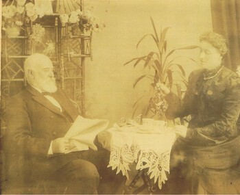
Photograph - OLIVE PELL COLLECTION: PORTRAIT OF A MAN AND A WOMAN
Copy of a photograph - sepia. 2 copies. Portrait of a man and a woman having tea. Written on back, could be,. At the end it says the lady is Edith Lansell - The second wife of Geo Lansell. It says Geo Lansell 1st wife, Bedielia died Sept.1880. Also says (children all from Edith).Agnes S. Morris, Dunolly.person, group, lansell family, olive pell collection. portrait of geo and edith (2nd wife) lansell. -
Whitehorse Historical Society Inc.
Document, Fromelles, 2012
Transcription of talk on the Battle of Fromelles.Transcription of talk on the Battle of Fromelles by Lambos Englezos to Whitehorse Historical Society 14 April 2012. With map of battle area. Tape at NP 3908Transcription of talk on the Battle of Fromelles.world war 1914-1918, fromelles -
 City of Kingston
Pamphlet - Colour, H. R. Hill & Co, Walker's Estate, Cheltenham for sale by public auction, c. 1923
Sales plan for land in the suburb of Cheltenham, encompassing both sides of Walker Grove, a section of Centre Dandenong Rd and Axelton St. The developing urban area of Cheltenham within the City of Kingston. This land sale pamphlet illustrates the subdivision of land within the municipality and the changing demographic of the district as new houses are constructed.Black and white pamphlet advertising for private sale the Station Entrance Estate, Highett. Incorporates a map of the estate bordered by Wickham Road, Railway Parade, Highett Road and Point Nepean Road.Handwritten in black pen on subdivision map: 'x' written on subdivisions 2, 3, 8-11, 15-17, 19. Potentially indicating that these properties did not sell at auction. Handwritten in black pen on subdivision map: assumed sale price on subdivisions 1, 4-7, 12-14, 18, 20-31. land sales, cheltenham, estate -
 Glen Eira City Council History and Heritage Collection
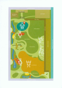
Event Run-sheet and Map, "Booran Reserve Official Opening"
This run-sheet and map were used for the opening of Booran Reserve at the corner of Booran and Glenhuntly Roads on Tuesday 11 April 2017. The Reserve was officially opened by the Mayor, Cr. Mary Delahunty and The Hon. Philip Dalidakis, MP, Minister for Innovation. The run-sheet contains information about the Order of Proceedings of the opening ceremony. The map notes the locations of reserved parking, the route taken by Mayor Mary Delahunty and Minister Philip Dalidakis through the Reserve, and the speech and smoking ceremony site. The site of the Reserve was previously the Caulfield Service Reservoir.Black and white printed run-sheet, and green, teal, red, yellow, blue and khaki colour printed map -
Tatura Irrigation & Wartime Camps Museum
Folder - survey maps
Maps of no 14 A, B, C and D internment camps and documents on Loveday Camp, South Australia. Donated by Gerhard Meinke concerning Loveday Camp. Brief outline of camps life, release and repatriation, list of deaths, of POW's and internees.Blue back clear plastic folder containing maps of No 14 camp and documents on Loveday Camp.gerhard meinke, loveday camp, camp 14, south australian internment camps, japanese internees -
 Warrnambool and District Historical Society Inc.
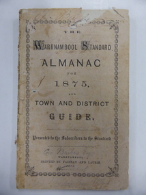
Book, Warrnambool Standard Almanac 1875, 1875
This booklet was given to subscribers of the Warrnambool Standard as an almanac for the year 1875. It was the first of these Standard Almanacs and replaced the yearly diary which was previously printed in the newspaper. These Standard Almanacs were published yearly from 1875 to 1930 and contained information for the residents of Warrnambool and district on the year ahead – the names of local public officials, businesses, hotel keepers, school personnel, local organizations representatives etc. The Warrnambool Standard newspaper was established in 1872 and continues to this day. This booklet is of high significance as it is the first of the yearly Warrnambool Standard Almanacs and contains much valuable information on Warrnambool and district for the year 1875. It is a very valuable research tool for those studying and writing Warrnambool’s history and is a rare copy. This copy appears to have belonged to George Barber, the son of George Barber, a well-known solicitor who opened a legal practice in Warrnambool in 1855. He died in 1879 and it appears that one or more members of his family went to live in the Maryborough area as this copy came into the collection of the Warrnambool and District Historical Society via the Midlands Historical Society. This is a soft cover booklet of 80 pages plus many advertisements at the front and back. It has a buff-coloured cover with an ornamental border on the front cover and black lettering. The booklet contains a calendar and information on the people, organizations and businesses of Warrnambool and district in 1875. Some of the pages have been burnt at the bottom edges and there are several pages partly or wholly torn away. The pages have been annotated in many places, mostly in pencil but occasionally in ink. There are many names of the Barber family in the booklet. ‘Geo. Barber Esq. Warrnambool’(repeated many times) warrnambool standard newspaper, fairfax and laurie, history of warrnambool, standard almanac 1875 -
 Eltham District Historical Society Inc
Photograph, George W. Bell, Peck's Pool, Eltham, c.1955, 1955c
Also known as Peck's Dam, it is today situated in the Pedersen Way Reserve, MontmorencyBlack and white photographic print (8 x 10 inch)On reverse - "Pecks Pool Eltham. Geo. W. Bell"eltham, george w. bell collection, houses, montmorency, peck's dam, peck's pool, pedersen way reserve -
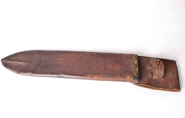 Montmorency/Eltham RSL Sub Branch
Equipment - Scabbard for Machete
Leather Scabbard for Machete (0128.1)GEO. PIZZEY & SON LTD. 1942 (Indent stamp) -
Glenelg Shire Council Cultural Collection
Document - Citation - Syd Cuffe, Town Crier, c. 1989
Framed citation, appointing Sydney John Cuffe as official town crier for the Glenelg Shire Council 17 Oct 1989. White certificate, black print, red seal of City of Portland, black wooden frame, glass over citation, wire for hanging on back, brown tape.Front: Signatures of Mayor, Councillor and GEO red biro -
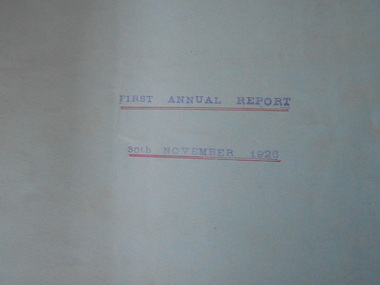 Bendigo Historical Society Inc.
Document - HANRO COLLECTION: FINANCIAL RECORDS 1926-1933
Nineteen Hanro Australia Financial Statements and Annual Reports 1926-1933. (Insert Attached List). Contained in light weight pale blue card folders. Some stapled and some loose sheets. Hanro Knitting Mills Pty Ltd (Aust) a). Financial Statements 30th June, 1926 b). First Annual Report 30th November, 1926 c). Financial Statements 30th June, 1927 d). Second Annual Report 30th November, 1927 e). Third Annual Report 25th October, 1928 f). Financial Statements 29th February, 1928 g). Financial Statements 30th June, 1928 h). Financial Statements 30th June, 1928 i). 4th Annual Report 30th October, 1929 j). 30th June 1930. 1 k). 30th June 1930. 2 l). Director's Report 30th June, 1930 m). Financial Statements 31st July, 1931 n). Sixth Director's Report 22nd October, 1931 o). Seventh Annual Report 31st July, 1932 p). Balance Sheet and Financial Statements 31st July, 1932 q). Balance Sheet and Financial Statements 31st July, 1933 r). First Annual report (after Company name changed) 13th November, 1933.Includes, H. Longstaff, Charles Handschin, Geo Lansell.business, retail, hanro financial records -
 Latrobe Regional Gallery
Painting, COLVILLE, George b. 1887 Aberdeen, Scotland. d. 1970 Melbourne, Untitled Landscape, Not dated
Oil on canvas Signed 'Geo. Colville' lower right corner of painting. -
 National Wool Museum
Photograph
Photo depicts the George Hague and Co. wool store, western beach, Geelong.GEO. HAGUE & CO. / PTY. LTD. / WOOL BROKERSwool stores, george hague and co. pty ltd, western wool warehouse, geelong, victoria -
 Linton and District Historical Society Inc
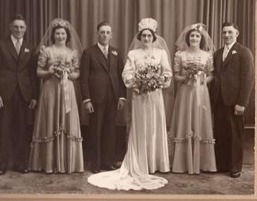
Photograph, Thornton Richards and Co, Ballarat, Wedding Photograph, Joyce Kerr and Bill Dickson, 1941, 1941
Married Sept 13,1941 at St. Cuthbert's Church, Ballarat. Bill Dickson of Newtown, Joyce Kerr of Linton.Sepia photograph of wedding group: Joyce Kerr, William (Bill) Dickson and four attendants."Best wishes from Joyce and Bill to Geo and Fran".joyce kerr, william (bill) dickson, weddings, thelma sharpe, fred dickson, lil dickson, bob dickson -
 Linton and District Historical Society Inc
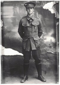
Photograph, Orlando Pyke
Black and white copy of original photograph showing a man wearing military uniform, standing to attention with his hands behind his back. Looks to have a scene of trees and water in the background. Some damage on the original photograph."1605 Geo (crossed out) Pyke Orlando Pyke"orlando pyke, australian imperial forces, world war i, world war 1914-1918 -
 Bendigo Military Museum
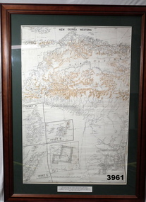
Map - MAP, NEW GUINEA FRAMED, 1941 onwards
Map of Western section of New Guinea. Black print on white background with mountain ridges in tan. Mounted with green border & brown wooden frame, glass front & white cardboard backing with wire hanging strap on back. Inset LHS bottom: A: Aroe Island B: KIA Island C: Taniimba IslandPrinted in black at top centre: “NEW GUINEA WESTERN’ Printed on border under map: “These escape maps were carried in the zip pockets of life jackets by fighter pilots in WW2. This map was presented to A.S.R. on the 12/7/79 by Councillor Ian McKenzie, Mayor of Eaglehawk, who served as a fighter pilot in 78th SQN in S.W. Pacific area during 1943-44.”map, new guinea, western, raaf -
 Federation University Historical Collection
Map, Ballaarat Gold Field, 1861, 21/10/1861
A party of surveyors camped by Yuille's Swamp (later Lake Wendouree) and surveyed the countryside for a map to be produced by the Geological Survey of Victoria. In November 2004 the Central Highlands Regional Library presented a special edition of 200 copies of the 1861 map reproduced from a copy in their collection. Original geological map of Ballarat showing property, waterways, mines, churches, schools, water races, and garden reserves. It was compiled and drawn from the surveys of Mining Surveyors Davidson, Fitzpatrick and Cowan.Compiled & Drawn from the Survey of Mining Surveyors Davidson, Fitzpatrick and Cowan & the Plans in the Surveyor General's Office by J. Brahe, 21st October 1861. R. Brough Smyth, Secretary for Mines. The Honourable J.B. Humffray, M.L.A. Commr of Mines.ballarat, map, davidson, robert brough-smyth, fitzpatrick, cowan, yuille's swamp, public garden reserve, manure depot, black hill, ballarat east, old post office hill, pennyweight hill, claytons hill, golden point, mining, railway, cricket ground, swamp creek, cemetery, sludge reserve, bakery hill, gaelic church, juvenile reformatory, orphanage, specimen hill, eureka lead, cattle yard hill, dalton's flat, chinese village, poverty hill, railway reserve, little bendigo diggings, pound reserve, allied armies, flour mill, agricultural reserve, marsh, survey reserve, survey corps, white flat, yarrowee, yarrowee creek, brache, j. brache, survey, ballaarat gold field 1861 -
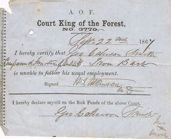 Bendigo Historical Society Inc.
Document - ANCIENT ORDER OF FORESTERS NO. 3770 COLLECTION: MEDICAL CERTIFICATE
Blue paper dated Sept 22nd 1867. I hereby certify that Geo. Catterson Smith of Iron Bark is unable to follow his usual employment. Signed H. L. Atkinson. M.D. Also signed at the end - Geo. Catterson Smith, his mark X, declaring himself on the Sick Funds of the Court.societies, aof, correspondence, ancient order of foresters no. 3770 collection - medical certificate, court king of the forest, geo catterson smith, h l atkinson -
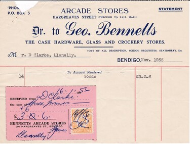 Bendigo Historical Society Inc.
Document - DONALD CLARKE COLLECTION: GEO. BENNETTS INVOICE
invoice dated Nov 1955 for Mr. D. Clarke, from Geo. Bennetts, Bennetts Arcade Stores, 290 Hargreaves Street, Bendigo purchased for goods at £3.00.06. Paid 16/01/1956. Geo. Bennetts, Bennetts Arcade Stores, The Cash Hardware, Glass and Crockery Stores, 290 Hargreaves Street, Bendigo. -
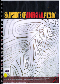 Victorian Aboriginal Corporation for Languages
Book, Bunj Consultants, Snapshots of Aboriginal Fitzroy, 2004
Features artwork by VACL Project Officer Mandy Nicholson.maps, photographswurundjeri, carlton gardens, alexandria gardens, maysar, batman treaty, oral histories